Petroglyphs Provincial Park Management Plan
This document provides policy direction for the protection, development and management of Petroglyphs Provincial Park and its resources.
Minister’s approval statement
Rock art, mute testimony to the legacy of prehistoric cultures, has weathered time and the elements to display the message of their creators. Petroglyphs, figures or images carved into rock, are a particularly intriguing and mysterious form of rock art. These rock carvings, while not abundant in Ontario, have been discovered in an area near Peterborough and are attributed to the Algonkian-speaking Indians.
An expression of the relationship of man, nature and the supernatural, the ancient symbols were carved into crystalline rock outcrops containing fissures and underground streams thought to be the home of spirits. The influence of the supernatural at this site was represented in the design and symbolism of the carvings. Studies to discover the meaning of all the glyphs, the stories they represent and the role of the carvings in the native folklore are still the subject of anthropological research. By deciphering the hidden meanings of the petroglyphs, our civilization will have glimpse into its past and a better understanding of the historical roots of our province.
In acknowledging the importance of this unique feature in both a provincial and national context, it was imperative that the petroglyphs site be safeguarded and protected while remaining accessible to the interested visitor. A park master plan was prepared to satisfy these concerns and also recognized that the facilities to be developed should not intrude on the area’s undisturbed setting. The theme and programming proposed in this plan will go a long way in establishing the historical feeling and simulating the environment of the former inhabitants. Therefore, in accordance with Sections 1a and 7d of the Provincial Parks Act, I endorse and approve the Petroglyphs Provincial Park Master Plan as the official policy for the preservation and future management of Petroglyphs Provincial Park.
Honourable Frank S. Miller
Minister
August, 1977
| Unit | Equivalent |
|---|---|
| centimetre (cm) | 0.3937 inches |
| metre (m) | 3.2808 feet |
| kilometre (km) | 0.6214 miles |
| square kilometre (sq km) | 0.3861 square miles; 100 ha |
| hectare (ha) | 2.4710 acres |
| cubic metre (cu m) | 35.3148 cubic feet |
| litre (l) | 0.2200 gallons |
| kilogram (kg) | 2.2046 pounds |
| kilowatt (kw) | 1.3410 horsepower |
| degree Celsius (°C) | ° C × 9/5 + 32 = degrees Fahrenheit (°F) |
Master plan highlights
Petroglyphs Provincial Park, an area of 1,555 ha, is approximately 56 km northeast of Peterborough in the Kawartha Lakes Tourist Area and close to the Trent-Severn Waterway System.
Petroglyphs is situated in the southeastern corner of the Peterborough Crown Game Preserve. Two trapping licences currently included in the park area will not be renewed when they are given up or transferred. The park area has since been excluded from a timber license area.
The park contains one of the largest single concentrations of rock carvings, called petroglyphs, dating back to the prehistoric times of the Algonkian-speaking Indian culture. The petroglyphs are significant on a provincial and national level. The glyphs site is presently surrounded by a 1.8-m chain link fence to protect the feature.
The park attracts a variety of users primarily families and children from many areas. In addition, school groups, academics and researchers are frequent visitors to the park.
The significant biophysical features of the area include interesting outcrops of marble, an imperfect drainage system, a meromictic lake which is chemically stratified and a primarily natural vegetational environment. Of the fauna in this area, the populations of both beaver and deer are excessive in numbers requiring management to reduce detrimental effects on the environment.
Petroglyphs Provincial Park is classified as an historical park under the Ontario Provincial Parks Classification System. The plan focuses on furthering the opportunities for visitors to view the glyphs while protecting them.
Zoning, development and management policies are prepared in conformity with the regulations governing the historical park classification.
The future development of Petroglyphs Provincial Park will change the protection and viewing facility at the petroglyphs site from the chain link fence to a boardwalk encircling the carvings. Future development will provide for day-use activities only in the form of picnicking and fishing at McGinnis Lake, viewing and hiking elsewhere in the park and scenic driving on the one-way route system to and from the glyphs site. The road system will be designed to be more scenic and more representative of the landscape during the days of the carvers. Hunting by bow and arrow only will be allowed in the park in order to control animal populations and also to simulate the carvers’ environment.
Introduction
Inside Petroglyphs Provincial Park lies one of the largest single concentrations of prehistoric rock art in Canada. At this site, carvings in the rock have been traced back to the Algonkian-speaking Indian people who are known to have lived 500 to 1,000 years ago in several areas of Ontario, including the area now known as the Trent Canal System. Rock art is a distinguishing feature of the Algonkian culture.
Studies in Algonkian mythology suggest that certain unusual landscapes and geological formations, such as waterfalls and underground streams, were the abodes of spirits and places to seek out visionary experiences. The petroglyphs site was considered to be just such a place. The presence of a subterranean stream below the petroglyphs site, which makes a rumbling sound that carvers perhaps thought was the voice of a spirit, may account for its reputation as a religious site and may have been the subject of some of the extensive carvings found here.
This master plan’s main purpose is to provide guidelines for development and visitor services programming which will help to re-create an environment similar to that of the Indian carvers. It is intended to provide visitors with a better appreciation for and understanding of this nationally important site.
Regional context
Location
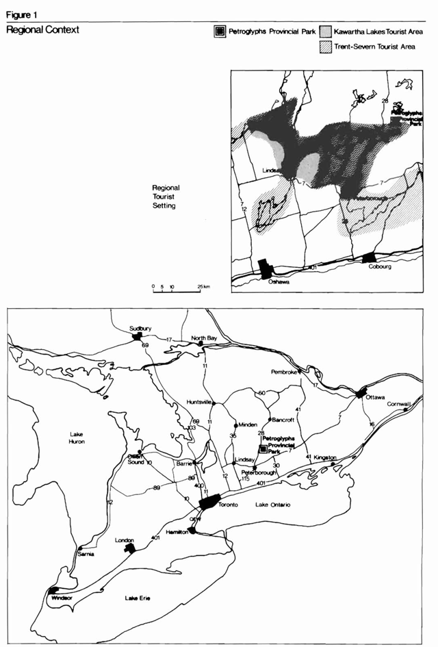
Petroglyphs Provincial Park is located about 56 km northeast of the city of Peterborough in the centre of a mixed forest or the Great Lakes-St. Lawrence Lowlands Forest Region, at the southern edge of the Canadian Shield (Rowe, 1972). Petroglyphs Provincial Park is very close to two of Ontario’s major recreational areas, the Kawartha Lakes arid the Trent-Severn Waterway System (Figure 1). The Trent-Severn Waterway System, linking the Bay of Quinte with the Rideau Canal System, provides a continuous water and recreational corridor from Ottawa to Georgian Bay. The system has been recognized by the provincial government and the federal government as having the ability to sustain intensive recreational use. The Federal-Provincial Rideau-Trent-Severn Recreational Development Study (1971) has classified the area within a 48-km radius of Petroglyphs (including the Kawarthas) through the Canada Land Inventory as having a high to moderately-high recreational capability. However, it is anticipated that the Trent-Severn system will have a limited effect on the visitation of Petroglyphs. This is due to the nature of the waterway system and to some extent the lack of adequate docking and transportation facilities in the vicinity of the park.
It is important to note that the federal government and the provincial government have committed themselves to the controlled and orderly development and management of this nationally significant recreational corridor. Optimum development of this area will be realized only after further planning and the implementation of recommendations contained in the Canada-Ontario-Rideau-Trent-Severn study.
The intensively developed Kawartha Lakes Tourist Area is located between the southern edge of the Canadian Shield and the limestone areas to the south. Visitation to the Kawartha Lakes area in 1973 was 112,000. Approximately 70 percent of the private cottages in the Kawarthas are owned by the residents of the Toronto-Centred Region. Numerous water-oriented recreational opportunities, such as boating, water skiing, bathing, canoeing, wildlife viewing and scenic viewing, are available. Overnight accommodations, including cabins, rental cottages, hotels, motels, and private campgrounds are available. The Kawartha Lakes vacation area is classified by the Canada Land Inventory as having a high recreational capability.
Figure 1: Regional context
Enlarge this map of the regional context of Petroglyphs Provincial Park (PDF)
Regional characteristics
Petroglyphs Provincial Park’s resource characteristics are typical of the surrounding area. The topography of the park is characterized by a low, undulating landscape, with swamp-filled depressions interspersed between rock ridges.
The park is situated within the humid continental climatic region and has warm summer days with cool nights and cold winters.
The area has a history of logging and severe fires which took place in the latter part of the 19th century and the early part of the 20th century. The present-day forest cover is mainly medium-age pine and hardwoods on shallow soils. The open rock areas have scattered trees and shrubs, while the lower, wetter areas often contain ash or elm forests or willow-alder thickets.
The park’s general geological features are not unlike the features found outside the park, except for the abnormal occurrence of marble outcrops. Indians in the distant past visited these marble outcrops and carved figures of various shapes in the soft rock which still exist today. The petroglyphs site is of national significance and constitutes the main reason for the establishment of the 1,555-ha park.
In the 1930s, it was recognized that the area immediately east of Petroglyphs Provincial Park had considerable mining potential for nepheline syenite. Nepheline syenite is a white crystalline igneous rock of considerable value and is used as an industrial filler when finely ground. The park and its immediate area have been surveyed continually by geological survey teams since the 1930s. A vast 890-km pear-shaped deposit of over 8 km in length was discovered approximately 8 km east of Petroglyphs Provincial Park. The material is mined from an open pit operation and is processed in nearby Nephton. It has been estimated that at the present rate of production, there is enough material to last 50 years. There is at present only one other deposit in the world being commercially mined.
The Peterborough Crown Game Preserve was established in 1927 as a refuge for deer and other game animals. It is a 153-sq km area, covering sections of Burleigh Township and Methuen Township, closed to the hunting of game. Most of the area is Crown land, with the exception of some patented lands on its perimeter and around much of Jack Lake. Petroglyphs Provincial Park is located in the southern section of the preserve.
Population centres
In 1975, the counties of Peterborough, Northumberland and Victoria and the Regional Municipality of Durham had a combined population of 434,000. Approximately 70 percent of this population resided in cities and towns, including the cities of Peterborough and Oshawa and the towns of Whitby, Newcastle, Campbellford and Lindsay. Since 1966, the population of this area has grown by about 39 percent.
Present services in the immediate area of the park are widely dispersed. The nearest store is 5 km away. The nearest centre with a full range of facilities is the village of Lakefield, 38 km away; Peterborough, 56 km to the southwest, offers a full range of urban amenities. In addition, several of the smaller communities nearby, such as Apsley and Burleigh Falls, as well as the local lakeshore communities, offer very basic services during the summer months.
Access
Currently the most direct access to Petroglyphs Provincial Park is from Peterborough along Highway 28 to Peterborough Country Road 6.5 km north of Lakefield. This road runs into Stony Lake Road which follows the south shore of Stony Lake and then turns north to Nephton. Three kilometres south of Nephton is a forest access road which now serves as the park’s access road.
Large-scale highway development projects between the Toronto and Peterborough urban areas are planned for 1970-1990. Plans are being prepared for a new four-lane freeway, Highway 407, from Markham via Highway 7 to Highway 12, east to the junction of Highway 35 and Highway 115 and then northeast along Highway 115 to Peterborough. Here the traffic will separate and either go east on Highway 7 or north on Highway 28 towards Lakefield and the park. These developments will reduce the travel time between Toronto and Peterborough and give visitors from Toronto faster and more direct access to the park.
Park area
Location and legal status
Petroglyphs Provincial Park, an area of 1,555 ha, is located in the township of Burleigh and the township of Anstruther in the county of Peterborough.
In 1959, the actual petroglyphs site was reserved as a Type B reservation under the Public Lands Act. An area of 939 ha, including the petroglyphs site, was reserved in 1971 as a Type C reservation under both the Public Lands Act and the Mining Act. The area became subject to regulation under The Provincial Parks Act in the fall of 1976.
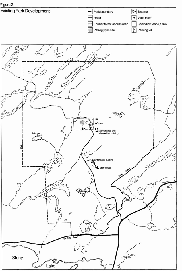
Existing park development
The petroglyphs site has been open to the public with limited services, facilities and staffing since 1968 (Figure 2). A maintenance man and two interpreters make up the park staff.
A forest access road, about 5 km long, now acts as the main park access road. This road directs visitors from the Peterborough County Road 6 to a 100-car parking lot adjacent to the petroglyphs site.
A 4-ha area, including the petroglyphs site and some surrounding area, is completely fenced by a 1.8-m high chain link fence. Part of the site within the area is similarly fenced. The inner fencing is only an interim security measure and will be removed when the park is properly developed.
Adjacent to the parking lot is a small, temporary maintenance building and a pair of vault privies. A path leads from the parking lot to the petroglyphs site. A small viewing platform, information board and a set of vault privies are the only facilities situated at the site.
Existing management programs
The Peterborough Crown Game Preserve
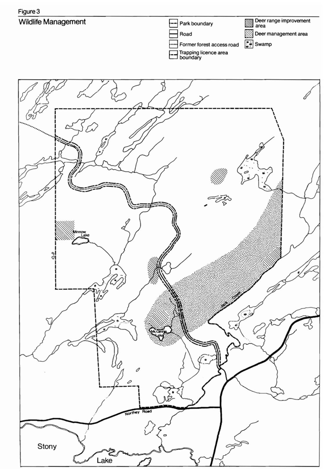
Petroglyphs Provincial Park is situated in the southeastern corner of the Peterborough Crown Game Preserve. This preserve was established in 1927 as a refuge for deer and other game animals. Hunting is not allowed in this area. Historically, the game preserve has been an important wintering area for deer. Therefore, the main reason for maintaining this preserve has been to provide a habitat which can sustain a healthy, optimum population of deer. Thus, areas within the park have been managed to improve the deer browsing ranges and yarding areas (Figure 3).
Figure 2: Existing park development
Enlarge this map of existing park development within Petroglyphs Provincial Park (PDF)
Figure 3: Wildlife management
Enlarge this map of wildlife management areas in Petroglyphs Provincial Park (PDF)
There are six trapping licence areas located within the game preserve, two of which are located within the park (Figure 3). Beavers were flooding areas capable of supporting deer, so a limited trapping program was introduced in the park to control the beaver population.
Fishing
The rainbow and brook trout populations in Minnow Lake are not natural populations. The lake was stocked with brook trout in 1964, 1965, 1967 and 1968 and with rainbow trout in 1969 and 1970.
Rainbow trout were introduced into McGinnis Lake in the late 1960s. However, by 1971 the smaller non-game fish population became too large, and the lake became poisoned with a non-residual fish toxin. The trout could not survive the combination of these two factors. Plans to reintroduce rainbow trout after 1971 were abandoned.
Forest management
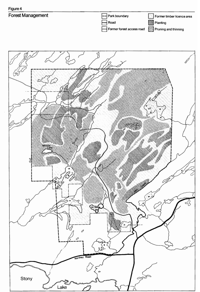
Since the early 1960s, most of the park area has been within a timber licence area (Figure 4) and managed for timber production on a continuous basis. Pruning and thinning of natural and planted white and red pine stands occurred on a regular basis. Approximately 130,000 white pine, 250,000 red pine and 100,000 white spruce were planted within the park area and the immediate vicinity. Recently, however, this licence was renewed, and the park area was excluded.
Figure 4: Forest management
Enlarge this map of forest management areas in Petroglyphs Provincial Park (PDF)
Market analysis
Surrounding recreational opportunities
At present, the park is only one part of the total complex of the Kawartha Lakes recreational opportunities. Other recreational facilities include the waterway systems of the Trent-Severn Canal, the Trent River and Otonabee River, the Kawartha Lakes, etc. These waterways provide opportunities for large boat cruising, water skiing and canoeing. Activities, such as wildlife viewing, hunting, fishing and scenic viewing, are also available to visitors in the Kawarthas. Most of these activities take place during the summer. However, winter recreation, based on downhill and cross-country skiing, ice fishing and snowmobiling, is extending the activity opportunities.
Public demand for these facilities is difficult to determine, but it appears that in the next 20 years there will be an ever-increasing demand for recreational accommodation and activities in this area.
The Kawartha Lakes Tourist Area offers many kinds and types of accommodation close to the park. These include private cottages, other parks, public recreation areas and private tourist accommodation, including rental cottages, cabins, hotel and motel rooms and tent trailer campsites.
Private tourist accommodation
Cabins, rental cottages, hotels, motels and resorts offer accommodation at varying prices in the immediate area of the site. Within a 48-km driving distance of the park, there are 4,200 public and private tent and trailer sites (1976 figures) and approximately 2,400 motel, hotel and cabin rooms available (Table 1). The total estimated capacity for these two types of accommodation is close to 25,000 at any one time.
Vacation homes
Vacation homes are residences that are used for only part of the year and generally for recreational purposes. Estimates of the total numbers of vacation homes in Victoria County and the northern portion of Peterborough County, centred on the Kawarthas, range from 50,000 to 60,000. Twenty-five thousand vacation homes are situated in the sector of the Trent-Severn study area included in the 48-km driving distance of the park.
Table 1: Accommodation within 48-km driving distance of the park
| Type of Facility | Number of Summer Facilities | Number of Spring to Fall Facilities | Number of Year Round Facilities | Total Number of Facilities |
|---|---|---|---|---|
| Tent/Trailer | 4,200 | N/A | N/A | 4,200 |
| Lodge/Motel hotel rooms | N/A | 320 | 900 | 1,220 |
| Cabins | N/A | 865 | 250 | 1,150 |
| Total | N/A | 1,185 | 1,150 | 6,570 |
| Estimated Capacity | Number of Summer Facilities | Number of Spring to Fall Facilities | Number of Year Round Facilities | Total Number of Facilities |
|---|---|---|---|---|
| Rooms and Cabins (3.5 people/unit) | N/A | 4,147 | 4,025 | 8,172 |
| Tent/Trailer (4 people/unit) | 16,800 | N/A | N/A | 16,800 |
| Total | 16,800 | 4,147 | 4,025 | 24,972 |
Parks and park reserves
At present, there are four provincial parks within a 48-km driving distance of the park. Ferris Provincial Park, Mark S. Burnham Provincial Park, Serpent Mounds Provincial Park and Silent Lake Provincial Park offer recreational activities of varying kinds. Nearby, the Kawartha Highlands and the three Crown land recreation areas of Cavendish-Anstruther (11,331 ha), Lavery Lake (3,237.4 ha) and Burleigh-Harvey (12,950 ha) all offer potentially exciting, but as yet undeveloped, recreational opportunities. The Peterborough Crown Game Preserve of Burleigh Township, within which the park is located, is another public recreation area offering wildlife-viewing of a high quality.
Historic and prehistoric sites
There are historic and prehistoric attractions in the area other than the petroglyphs site. Serpent Mounds Provincial Park has a well-developed pre-historic site. The Quakenbush site, about 8 km from the park, believed to be an Iroquoian village site, another historic site, but it is not yet open to the public.
There are approximately 20 historical plaques in the local area and several museums, as well as various buildings of historical and architectural significance. These include the Lang Mill and the old Choir Church in Lakefield (1853) as well as the residential buildings in Peterborough (Stone House, 1838) and Lakefield (Westover House, 1847).
Natural features
There are a number of natural features of geological, physiographic and ecological significance. These features, though not significant on a large scale, are of high local and interpretive value (e.g. the nepheline syenite deposit).
Canoe routes
Experienced canoeists can now use almost 322 km of routes in the northern part of Peterborough County laid out by the Ontario Ministry of Natural Resources for overnight or longer trips. The canoe routes traverse public waters and include portages on Crown land. Eels Creek, located just west of the park, is one of the more popular canoe routes in the area.
Day-use facilities and trends
Based on the results of a survey in 1970, an estimated 300,000 day-users visited nine selected sites during the summer. Over 80 percent stayed for one hour or less and listed sightseeing as the major reason for their visit.
The eastern end of the Trent-Severn system, especially the Kawarthas area, experiences heavy day-use activity. The Trent-Severn study emphasizes the need for more intensely developed day-use sites and a wider variety of facilities in the Kawartha Lakes area.
Park use
Since the park was first opened to the public in 1968, activities have been restricted to day-use only. There are two main categories of day-use, general tourist use and educational-scientific use. The former accounts for 95 percent of the present use.
User trends can presently be determined only from the on-site visitor registration book. The data from this book can be used with some degree of reliability. It has been determined from research that about 75 percent of the visitors to the site sign the book.
The registration data for 1975 has been used for determining user trends and other types of analysis.
Visitor trends
The annual visitation figures for the years 1974 and 1975 were 14,227 and 13,613, respectively. The park experiences the greatest visitation during July and August, which constitutes 53 percent of the total visitation. Of the remaining 47 percent, 20.5 percent of the visitation occurs in May and June, while 26.5 percent occurs in September and October. The highest daily visitation occurs during weekends and statutory holidays. Sunday is generally the busiest day. The highest daily visitation, 470 visitors, occurred on a Sunday in October, 1975.
School groups generally visit the park during May and SeptemberOctober as part of their regular school program. University groups, studying anthropology and other related subjects, also utilize the park during the same time period.
User origins and characteristics
Age composition
Research indicated that some 40 percent of the 1975 visitors were 45 years of age or over. Another 40 percent or so appeared to be in the 30 to 45 age group, usually with one or more children. The 15 to 30 age group is poorly represented except by high school and university students. Children under 15 and well-represented in school groups and as visitors with their parents.
Primary origins
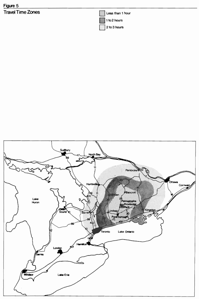
Petroglyphs Provincial Park is within three hours of the most populated area of Ontario (Figure 5). The following are some characteristics of the visitors to the park.
- Thirty-six percent originate from within a 48-km radius of Peterborough.
- Nine percent originate from the four local counties of Peterborough, Victoria, Northumberland and Durham.
- Twenty-three percent originate from Metropolitan Toronto and district.
- Thirteen percent originate primarily from southwestern Ontario.
- Twelve percent originate from the United States.
- Three percent originate from the other provinces.
- Four percent originate from outside North America.
Figure 5: Travel time zones
Enlarge this map of travel times for areas around Petroglyphs Provincial Park (PDF)
Monthly trends
Approximately 50 percent to 70 percent of the visitors to the park during the spring and fall are local people from Peterborough and the four nearby counties. The percentage of visitors from the Toronto area increases steadily from May to August. Most of the visitors in August list Toronto as their place of origin. Few visitors from the United States arrive until June. In June, July and August, approximately 15 percent of the visitors list the United States as their home.
The survey showed that visitors from Europe, other provinces and the rest of Ontario visited the park from May to October. No single month was more popular than another.
Future trends
Although it is difficult to determine what the future user trends for the park will be, an attempt to speculate on future uses should be made.
It is anticipated that the existing percentage of visitors to the park from the three local counties and the one regional municipality will increase in the future. Several areas within these counties and regional municipality are experiencing fairly rapid population growth. The effects of wider local publicity as well as increased day-use facilities are hard to determine at the present time, but both of these factors could conceivably increase the site’s utilization by local residents. If interpretation is presented in an orderly, scientific and educational manner, usage by school and university groups will almost certainly increase.
The visitors originating from the Toronto-Centred Region use the park on a home-park-home or home-cottage-park-home basis. An increase in usage by this group seems likely because of the projected increase in population in the urban area, coupled with an increase in demand for adjacent recreational opportunities and a better highway system.
An increase in usage by visitors from southwestern Ontario and nearby border states seems likely mainly because of proposed improvements to the highway system.
The effects of several factors influencing site visitation by various user groups are largely unknown. For instance, the effectiveness of increased publicity by the Ontario Ministry of Natural Resources and other agencies is unknown. Visitors from large urban areas seem more likely to be exposed to cultural and historical media and thus seem more interested in visiting the site as a result of the information.
In terms of absolute numbers, park use in the near future is not expected to exceed twice the maximum 1975 visitation which was 1,000 visitors a day. One thousand visitors a day is felt to be the maximum use the site can withstand.
Biophysical resources
Climate
The nearest weather recording station is in Lindsay. Both the park area and Lindsay are situated in relatively flat areas at approximately the same elevation (259 m above sea level). They vary only 16 km to 32 km in distance from Lake Ontario and its modifying climatic influence. The general climate of the area is typical humid continental summer (Trewartha, 1953). Within the local area of the park, there are no great variations in elevation or other features which might cause wide microclimatic variability. The data on temperature and precipitation is summarized from data recorded over a number of years at the Lindsay weather station.
Temperature
Summer monthly maximum temperatures are moderate, generally in the 24°C-27°C range, which provides for an idea recreational climate, if the humidity is low. Nights are generally 8°C-10°C cooler. Normal winter temperatures for the region range from a mean monthly minimum of -13°C to a mean monthly maximum of -1°C to -2°C.
Table 2: Temperatures
| Month | Average Mean Maximum (°C) | Average Mean Minimum (°C) |
|---|---|---|
| January | -3 | -14 |
| February | -3 | -14 |
| March | 2 | -8 |
| April | 11 | -1 |
| May | 18 | 6 |
| June | 24 | 11 |
| July | 27 | 13 |
| August | 25 | 12 |
| September | 21 | 8 |
| October | 14 | 3 |
| November | 5 | -3 |
| December | -2 | -10 |
| Yearly Average | 12 | 1 |
Precipitation
Annual precipitation is in the range of 81 cm to 86 cm. Rain is evenly distributed April through October, with less precipitation in the winter months. Total annual rainfall is normally 64 cm to 66 cm.
The average annual snowfall of 193 cm is concentrated in the months of November through March, with January and February having the highest totals. The depth of snow in the park area is important to the local deer population which winters in the park and is probably adequate for snowmobiling and other winter recreation activities. Snowmobiling is, however, potentially hazardous to the site, the fragile local environment and the deer population.
Table 3: Precipitation
| Month | Average Monthly Rainfall (cm) | Average Monthly Snowfall (cm) |
|---|---|---|
| January | 2.3 | 46.7 |
| February | 1.5 | 39.4 |
| March | 3.6 | 31.0 |
| April | 5.6 | 10.4 |
| May | 7.6 | .3 |
| June | 6.9 | N/A |
| July | 7.9 | N/A |
| August | 7.1 | N/A |
| September | 8.6 | trace |
| October | 6.6 | .8 |
| November | 4.6 | 21.3 |
| December | 3.0 | 42.4 |
| Yearly Average | 65.3 | 192.3 |
| Total precipitation | 84.6 | N/A |
(Conversion of snow: 25.4 cm of snow equals 2.54 cm of rain or precipitation).
The monthly bright sunshine totals, which are high during the summer, enhance the viewing opportunities. Overall, the climate in Petroglyphs Provincial Park is very suitable for the pursuit of recreational activities in both summer and winter.
Geology
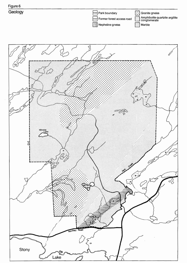
The park area lies on the southern edge of the Canadian Precambrian Shield, some 8 km north of the contact zone with the Paleozoic sedimentary rocks of Southern Ontario. The Precambrian Shield in Canada is divided into five provinces and several sub-provinces based on general structural trends. The park is located in the Grenville province, which extends from Labrador to Lake Huron. The Grenville province is comprised of rocks of the Early, Middle and Precambrian eras and has evolved in a complex manner. Late Precambrian rocks underlie Eastern Ontario and are composed of metasedimentary gneisses, marbles, basic metavolcanic and granitic instrusions. The park area’s geologic structure is shown in Figure 6.
A basic understanding of the complex history and structural deformation of the rocks in the park area is an invaluable aid in the interpretation of the two geologic themes: the ruggedness of the shield and the abnormal occurrence of marble outcrops in the area.
The rocks in the area from Stony Lake to Cardiff Township were dramatically folded and metamorphosed in one or more Late Precambrian orogenies. Two separate, major fold areas are evident. Structural domes are located at the intersection or antiform folds to the west of the park, in the eastern half of Harvey Township and west of Burleigh Township. One of these is situated just north of Burleigh Falls.
A series of structural domes centred in Methuen Township are composed of metasedimentary and metavolcanic rocks, gabbro and nepheline syenite, which underlie the park and the area to the south and east. The marbles, which at one time resembled the present Paleozoic limestones, where gradually recrystallized and metamorphosed under the influence of high temperature and pressure. The process was induced by burial and tectonic activity at extreme depths which caused deformation of the earth’s crust. Numerous smaller instrusions, mainly granitic dikes, cut the marble.
The main features of the Menthuen Dome area are small domes, basins and folds with rapid reversals of plunge. The marble deposits form part of the Lasswade marble-amphibolite unit.
The rugged landscape of the Shield country has been intensified in the park area because of the folding and differential erosion of the marble and other rocks. This has made the land extremely difficult to traverse and doubtless contributed greatly to the isolation and way of life of the Indian peoples who inhabited the area in prehistoric times. A theme of major interpretive importance can be based directly or indirectly on the geological phenomenon.
Another result of the intense geological activity, which is of major importance to the park story, is the creation and exposure of the large areas of marble used by prehistoric Indians as a base for carving.
Figure 6: Geology
Enlarge this map of the geology of Petroglyphs Provincial Park (PDF)
Characteristics of the marble
Knowledge of the nature of marble and its components, upon which the glyphs are carved, is essential to the preservation of the site and the preservation and interpretation of the glyphs.
Marble is one of the softest rocks of the Precambrian Shield. Its mineralogical composition is predominantly calcitic calcium carbonate with a standard hardness of three on the Moh’s Scale of Mineral Hardness (soft= 0 and hard= 10).
The rock is an aggregate of coarse calcite crystals. The calcite crystal in the rock has several excellent cleavages and can be split readily with a sharp blow. It is readily abraded by hard-soled shoes and most other rocks or minerals. In addition, it is soluble in weak natural acids. However, although each crystal can be split easily along its cleavages, the internal structure of the aggregate rock is fairly strong. Bedding planes and joints are rare in the rock, especially in the vicinity of the glyphs.
Thus, the main immediate danger to the carvings is abrasion by shoes, boots and implements. Chemical weathering will erode the carvings over a long period of years. Physical weathering, such as frost heaving is likely to be serious only at the surface of the rock, where prolonged chemical weathering has dissolved the calcite crystal boundaries.
Topography
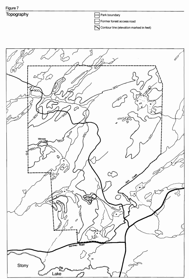
In terms of elevation, the park is situated mid-way between the lowlands of the St. Lawrence-Great Lakes area and the Algonquin Highlands of the Shield, which rise to over 579 m in Algonquin Provincial Park.
The land surface in the area of the park follows a gently rising trend, sloping gradually upward- from southwest to northeast (Figure 7). The range in topography in the park is approximately 45.7 m. In general, the area is characterized by a low, hummocky relief. Rocky ridges are interspersed with swamp-filled depressions. Rapid reversals of rock facing and plunges are remnants of the cross-folding of the rock. The rock ridges, however, are not especially dramatic, and no large cliffs of hills are present.
Topographically, the park area can be split into two areas, the higher rocky plateaus to the northwest and northeast of the forest access road and the lowland swamp region to the south and west of the road.
Figure 7: Topography
Enlarge this topographical map of Petroglyphs Provincial Park (PDF)
Drainage
The natural drainage of the area of the Shield containing the park is from northeast to southwest. The moraine blocked Kawartha Lakes system collects most of the stream run-off from the Shield area of Peterborough County and Victoria County. Several larger river systems connect the Kawartha Lakes and ancillary lakes to the Great Lakes-St. Lawrence system.
The streams in the immediate vicinity of the petroglyphs site drain into Stony Lake. The largest of these is Eels Creek, which runs along the length of Highway 28 from Apsley to Haultain, where it cuts southeast to flow over High Falls and into Stony Lake. Jack Creek is the other major water course in the area. It forms the southeast boundary of the park and also flows into Stony Lake.
Bodies of water constitute less than five percent of the total park area. Two small lakes within the boundary of the park are Minnow Lake (1.6 ha) in the southwest and McGinnis Lake (4.4 ha) in the central area of the park. McGinnis Lake has been classified as a meromictic lake. Meromictic lakes are rare: there are only four others in Southern Ontario which are readily accessible. The waters of a meromictic lake are permanently stratified into two or more layers, with a different chemical composition in each layer. The bottom layer has a greater concentration of dissolved salts, making it permanently heavier than the upper layer. Therefore, dissolved oxygen cannot circulate into the lower layers. However, while the lower layers cannot support life, life can still exist in the upper layers.
Studies have been done on McGinnis Lake in the past two or three years to determine the actual cause of meromixis, whether or not it is a natural occurrence or man-induced, the productivity changes and the changes in the species composition of the plankton community. Some of these questions are still unanswered and require further research. Little of this research will affect the future visitor use in the park. However, McGinnis Lake is close enough to the glyphs site that it may have influenced the historical uses of the site. Future research may prove interesting to find out when the lake became “meromictic” and if this coincided with any change in the use of the area by native peoples. It is believed that water-oriented recreation on the lake will be detrimental to the physical and chemical make-up of the lake, and for this reason, recreational activities should be restricted, and McGinnis Lake should be looked upon as a locally significant feature.
Several small lake-swamp complexes occur in the vicinity of the northern boundary of the park. A number of spring runoff or intermittent streams exist within the crystalline limestone formation, and some drain into many of the low-lying, swamp-filled depressions. The latter are numerous, and in most cases, are the result of beaver activity. The location, boundaries and water depth of these are constantly changing. There are two particularly large swamps in the park area. One swamp (12 ha to 16 ha in size) is located directly southwest of the petroglyphs site, while the other (5 ha to 6 ha in size) is located on the northeast side of the forest access road, approximately 1.6 km southeast of the petroglyphs site.
Physiography and soils
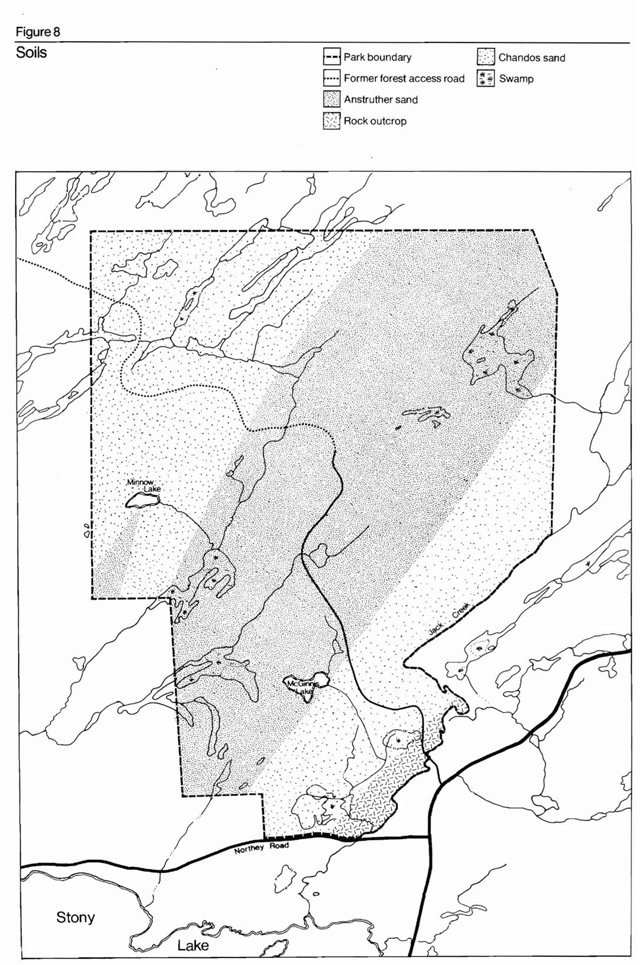
Physiographically, the park area is composed of bare rock outcrops interspersed with slightly depressed areas (Figure 8). The complex is of moderate relief. The latter areas are covered mainly with shallow glacial deposits of outwash sand and till. Organic wet swamps, resulting primarily from beaver activity, fill many of the depressions between the rock ridges.
Continuous, extensive or deep glacial deposits, common to Ontario, south of the Shield area, are not present in the park area. The net result 9f glacial action has been the scraping bare of the Shield rock areas and the deposition of sand and coarse rock material in shallow areas only.
The soils in the park area are classified as orthic podsol soils or deposits in which a profile can develop. Chandos sand and anstruther sand are the two soils of this class found in the park (Figure 8). Organic soils are found in the low flooded areas in Petroglyphs. Boreholes in the area indicate sand and soil depths ranging from 0.3 m to 1.5 m.
Typical orthic podsol soils are found in the park area on igneous or associated rock. These soils have very little capacity for agriculture.
Figure 8: Soils
Enlarge this soil map of Petroglyphs Provincial Park (PDF)
Flora
Forest cover
The plant geography and forest ecology in the park is typical of the Great Lakes-St. Lawrence Lowlands Forest Region (Rowe, 1972.) This region contains a mixed coniferous hardwood forest, with some pure boreal species mainly in low, wet areas or on the higher uplands. One would expect to find a combination of white pine, red pine, hemlock, white spruce and deciduous hardwood species, such as white birch, sugar maple and red oak, in the upland parts of the region. Wetter lowland areas would normally contain species of elm, ash, red maple, white cedar, balsam, tamarack and black spruce.
The park vegetation today is the result of approximately 60 years of re-growth following the disastrous fires of the early 20th century. The present vegetation forms a transition between fire-ravaged remnants of the 1910 period and the original forest cover encountered by the pioneers and the prehistoric Indians. Natural regeneration and some planting are helping to restore the forest cover over time to a more mature phase.
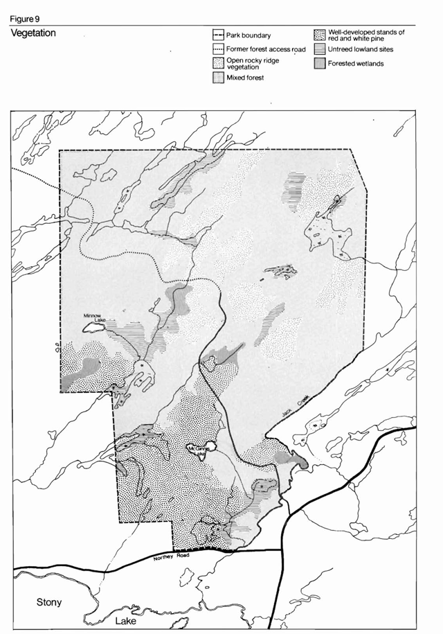
The forest cover in this park may be divided into five communities: the vegetation communities of the open, rocky ridge areas; the mixed forest on the sides of the slopes; the well-developed red and white pine stands; the untreed lowland areas and the forested wetlands (Figure 9).
Figure 9: Vegetation
Enlarge this vegetation map of Petroglyphs Provincial Park (PDF)
If any community could be described as characteristic of the park, it would be the open, rocky ridge areas. These areas are thinly covered with herbs and grasses and scattered tree species, such as white birch, trembling aspen, white pine, white spruce and red maple. This community illustrates the colonization and successional processes from bare rock to lichens and mosses to grasses to woody-stemmed plants and finally to trees. There is a wide variety of understory and ground cover vegetation species associated with this community. A complete list of the species is available from the park staff.
On the slopes of the ridges, where the soil is often deeper but is still fairly shallow, the vegetation changes to a mixed forest. Tree species found in these areas reach only moderate size and include basswood, trembling aspen, red maple, sugar maple, white cedar and red pine. Hazel and wild sarsaparilla are the only understory vegetation in this community.
Well-developed stands of red and white pine, which in most cases have been managed for harvesting, are found in several areas of the park, but particularly in the south-central and southeastern sections. The ground cover associated with these pines includes twinflower, club moss, honeysuckle, sarsaparilla and wild rice grass, among others.
Lowland areas, which usually occur in valley bottoms, often lack suitable soil development and are devoid of trees. However, they do usually contain a variety of ground cover plant life. Among the species found here are cardinal flower, closed gentian, Canada elderberry, meadowsweet and others. In smaller pockets of deep soil, not flooded by beaver activity, white cedar can achieve considerable growth.
The rising of the water level, as a result of intensive beaver activity, has transformed most of the forested areas into wetlands. Now, instead of mature forests, this area contains dead or dying trees, such as white ash, elm, silver maple, trembling aspen and white pine. The plant species associated with this environment are typical of wetlands and include cattails, burreed, yellow pond lily, duckweed, joe-pye weed, beggar-ticks and elodea.
Research conducted so far has revealed no unusual or rare plant communities or species in the park area.
Fauna
It is highly probable that in prehistoric times the animals in the park area played an important role in the life of the Indian carvers. These people were basically hunters and gatherers and relied heavily on fish and game for their food. They also adopted many religious and cultural beliefs from the local animals and the surrounding environment. A number of glyphs depict animals and animal tracks that were important to them.
Little information is available on the wildlife of the park area, especially for the following species: waterfowl, game birds, other bird species, reptiles, amphibians, small mammals and insects. There is a considerable amount of data concerning fish, especially stocked populations, deer and beaver.
Fish
Fishing in Minnow Lake and McGinnis Lake has been somewhat limited in past years. These lakes are moderately productive and suited to trout. Fishing from canoes is more successful than fishing from the shore.
None of the lakes contains natural populations of game fish. McGinnis Lake, prior to 1971, contained a mixed fish population of bullhead, pumpkin seed, yellow perch, large-mouth bass, suckers, small-mouth bass and rainbow trout. The non-game, small fish population became too large, and poisoned the lake in 1971 with a non-residual fish toxin. All species of fish were killed. It is planned to restock the lake with rainbow trout in the near future.
Minnow Lake is a steep-sided, clear lake with a population of pumpkin seed, suckers, brook trout and rainbow trout. It was stocked with brook trout in 1964, 1965, 1967 and 1968 and with rainbow trout in 1969 and 1970.
No other waters in the park area have any populations of game fish. It is evident from the history of the fishing potential in this area and the historical analysis of the Indians’ lifestyle that Indian carvers did not frequent this area for its fishing opportunities.
Mammals
Petroglyphs Provincial Park is ranked by the Ontario Land Inventory as having a moderately-low capability to support wildlife game species. However, the park and its surrounding area do sustain a high quantity and diversity of animal life because of numerous factors. The park has an extensive area of relatively unsettled land, which provides a suitable range for predators such as wolves. The protection afforded by the Crown game preserve has encouraged large populations of some animals such as deer. Settlements to the south and west have encouraged a concentration of game animal populations in the park area. The area is in a suitable stage of vegetation succession, which serves to attract and support large populations of animals such as deer and beaver.
The park area, situated in the Peterborough Crown Game Preserve, constitutes one of the major deer-yarding areas in the district. Although deer are subject to three main environmental controls, climate, predators and food, the last factor in particular has been instrumental in controlling their numbers in the last few years.
In prehistoric times, natural predators controlled the size of deer populations. Later, hunters helped control this population. Presently, however, neither of these two facts is influential to any large degree in controlling populations. This is particularly true of hunting in the preserve, which is no longer allowed. Consequently, there is a large permanent deer population which has over-browsed the preserve and has created serious food shortages.
The park is located in an area frequented by moose, and the habitat of the park appears to be moderately suitable to their needs. However, no sightings have been recorded, and no information is available on their presence.
Another mammal which is said to frequent the site is the black bear. Although no sightings have been recorded, fresh black bear tracks have often been seen in the park area.
A small population of timber and bush wolves exists in the area. The game preserve and surrounding area are the territory of a pack of four timber wolves. Both timber and bush wolves hunt deer and beaver as natural prey.
The beaver population in the preserve is considered to be high. The beaver is responsible for flooding large areas of land capable of supporting the extensive deer populations. Consequently, in 1970-71, a limited trapping program was started in the preserve in an attempt to reduce the problem. Six trapping areas were delineated in the preserve. The following are the 1970-71 figures for the yields of the two areas falling within the park area:
- Beaver: 63
- Mink: 6
- Muskrat: 45
- Raccoon: 2
- Otter: 1
The trapping activities yielded a total of 117 fur-bearing animals in 1970-71.
Cultural resources
History
The petroglyphs site was discovered in 1924 by Mr. Charles Kingam, a local resident and a member of the Peterborough Historical Society. His discovery was not widely publicized. Thirty years passed before there was a renewed interest in the site, prompted by its rediscovery by a geological team from Industrial Minerals of Canada (Indusmin Ltd.), who stumbled across the carvings on May 12, 1954. The first report was completed by Paul Sweetman, a member of the team from the University of Toronto, who mapped the site and made a preliminary study and record of the carved characters. His survey recorded 92 glyphs, including animals, human and humanoid figures, of which triangular figures were the most common. An extensive search for associated village remains or other petroglyph sites along with ecological surveys has since been made. These surveys did not have any positive results. However, two other small petroglyph sites were uncovered in the immediate area of the main site.
An intensive re-examination of the site was done by Joan and Romas Vastokas of Trent University in the summer of 1967. Their findings were published in the Sacred Art of the Algonkians in 1973. This study was instigated for several reasons. First, the petroglyphs were believed to be more extensive than the original report had indicated. Secondly, the introduction of a clear hiking trail in the 1950s and a forest access road in 1966 allowed easier access to the site and thus increased the number of visitors. The increase in the number of visitors to the site in turn increased the possibility of overuse and vandalism and further justified the new study. The study revealed that new information was needed on new methods of protecting the site, reducing rock erosion and providing new interpretive programs to explain these problems.
The Vastokas checked 232 m of rock, mapped 900 glyphs and excavated the area’s crevices and depressions. Their study produced approximately 300 distinct glyphs and 600 vague glyphs, 30 hammerstones and seven pieces of clay pottery. Their study revealed that there was a main petroglyphs site and two smaller ones nearby (Figure 10).
The main marble outcrop on which the glyphs are carved is roughly 12 m to 20 m in size and rectangular in shape. It extends north-south and slopes towards the rising sun. In addition, there are numerous crevices and circular potholes in the site’s facies and a wide and deep fracture with an active underground stream in the outcrop. The stream, which, is especially audible during spring runoff, is believed to have personified religious spirits. It was probably a major deciding factor for the large concentration of glyphs on one particular limestone surface.
Figure 10: The Petroglyphs of the main site
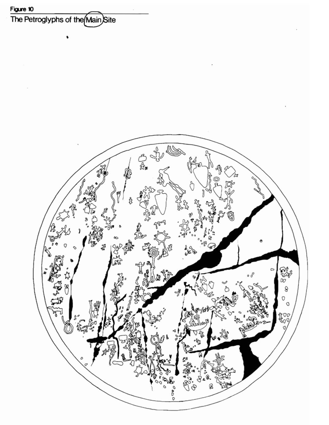
One of the smaller sites is directly north of the major concentration, while the other site is 250 m to the northwest. The second small site consists of 23 distinct glyphs. In addition to these sites, there are a few glyphs scattered through the peripheral areas of the site. The Vastokas recorded glyphs that ranged in size from centimetre-sized dots to 3-m snakes. The carving depths vary from vague, barely perceptible impressions to distinct, deep impressions, such as the large crane which is almost 4 cm deep. The glyphs would have appeared white when freshly done and would have been a definite contrast to the weathered grey of the surrounding rock. Recently, however, the glyphs have been made more distinctive with the application of black wax crayon. This process facilitates the recording of the carvings, and allows for corrections based on future evidence that superimposition has occurred or evidence that a glyph has been coloured inaccurately.
The 30 hammerstones discovered on the site are believed to be the instruments used by the Indians to make their carvings in the marble. The hammerstones are made of gneiss and were found in crevices among decaying matter. While marble is three on the Moh Scale of 10 for rock hardness, gneiss is harder and measures six or seven. Therefore gneiss makes an ideal tool that is readily available in the vicinity of the site.
Leading authorities estimate the age of the petroglyphs to be about 500 to 1,000 years old. It is difficult to date rock art because there is no method of accurately identifying the age of inanimate objects. Carbon dating, in this instance, is useless because it can only record formerly animate objects. The more recent date of 500 years is arrived at because none of the carvings indicates European contact, and the outside date of 1,000, rather than 3,500 years, is fixed as a result of the historical data pertaining to the semi-nomadic people.
Evidence indicates that the Ojibwa of the Algonkian linguistic group in the Late Woodland Era were the glyph carvers, since they were historically in the area, and some of the glyph styles are identical to their documented birch bark scrolls. The site probably filled the role of a sacred place for consecutive generations over a 500-year period. Also, the fact that they had an oral system of communication helps to explain why the site sank into oblivion.
To a native carver, the natural rock features would have represented a sacred site. According to Algonkian mythology, holes in rock were entrances to the spirit world situated directly beneath the surface. It was also believed that spirits preferred to live near water. The site in the park combines both features and would have been an ideal place to communicate with the supernatural. Thus the petroglyphs site served as a natural shrine for the Algonkian culture. Although this site is remote, it is still close to the Trent-Severn system, the old Algonkian travelway.
Historically, Algonkian youth, particularly the Ojibwa, journeyed to remote places for four to 10 days. This traditional retreat was probably based on the concept that the youth’s pilgrimage and endurance signified his entrance into manhood. They executed drawings and carvings as a symbol of their changes. They frequently returned to the site to add to their original carvings.
Paul Sweetman developed the idea that the natives searched for visions associated with the change into manhood and that these visions were the main reason for the carving of the petroglyphs. Sweetman went on to say that individuals in a culture based on small, isolated hunting bans saw the relationship between man and animal as a delicate and magical one. He though the basic theme of the site was a depiction of man’s relationship with nature, with an underlying theme of fertility and sexuality.
The Vastokas concluded similarly that the petroglyphs were done by the Ojibwa of the Algonkian linguistic group. However, they believe that the shamans, rather than young boys, were responsible for the carvings, because the symbols are too religiously complex to have been executed by inexperienced carvers. In the Algonkian culture, the shamans were the people with supernatural powers acquired through visions. These visions were often received at sacred places, such as the petrolgyphs site. The Vastokas believed that the visions were manifested as symbols representing man’s relationship, not with L nature, but with the supernatural.
Evidence indicates that no effective dream drugs existed for this culture, but physical deprivation, whether artifically or naturally induced was usually sufficient to enter the supernatural world.
Three definite carving styles seem to be present. The deepest glyphs are in the area of the highest concentration in the middle of the northern section of the largest site. It is hypothesized that the northern end of the rock face was used first, and, as it filled up, the carvers moved toward the southern end. Later, as it became cluttered with carvings, the carvings shifted toward the north again because the original glyphs had faded. It seems that the deep, stylized glyphs were superimposed on older figures by making deeper cuts with coarser tools. This ensured that the latest carvings were more distinct. One other hypothesis relating to the depth of the petroglyphs impressions is that the power emanating from the vision that inspired the images, such as the sun-figure, the crane and the triangular shapes, was so strong that the carver reaffirmed this faith or mana yearly with renewed cutting.
The next style of carving occurs at the southern end, where the glyphs are shallower but freer in their motion and more natural. What appears to be a third style is found at the second site, which is older and more weathered. It contains the only fish carving among all the glyphs and is composed of subject matter different from that of the other two. Although the historical and cultural context into which the carvers of the site can be fitted is delineated fairly well, many questions about the site are as yet unanswered. The general view is that the carvers reflected their spiritual experiences in as permanent a medium as their environment permitted. The glyphs depict the close harmonious relationship between the Ojibwa and their environment, ultimately penetrating into realms beyond the earth.
In the Shield’s woodlands, there are over 300 known occurrences of rock art, pictographs and petroglyphs attributable to the Algonkian peoples. Of the 300, only some 20 are petroglyphs. The majority of occurrences are pictograph rock paintings. The pictograph rock paintings in the Canadian Shield are more recent than the petroglyphs carvings. It appears that the Peterborough petroglyphs are far removed from the other petroglyphs and pictograph sites, most of which are located along the Ontario-Manitoba border. The Peterborough petroglyphs are unique because this site is one of the largest concentrations of petroglyphs in North America. It is the correlation of styles which links these widely-separated sites.
Other Ontario rock art sites accessible to the public are found in Sandbar Lake Provincial Park, Sioux Narrows Provincial Park, Bon Echo Provincial Park (Mazinaw Lake), Lake Superior Provincial Park (Agawa Bay) and Missinaibi Lake Provincial Park.
Even sites which are not directly attributable to the Algonkian culture can be related to the petroglyphs. For example, one petroglyph depicting a snake with dots signifying eggs is a reproduction of the landscape of the Adena-Hopewell Indian burial ground at Serpent Mounds Provincial Park.
Park policy
Park goal
The goal of Petroglyphs Provincial Park is to provide for the continuous physical protection and preservation of a unique and important archaeological resource in a natural setting, while providing visitors with the opportunity to view the petroglyphs on a day-use-basis in a manner which will increase their understanding, appreciation and enjoyment of this and other archaeological/historical resources in the province.
Park objectives
The following objectives must be met in order to fulfill the above stated goal:
- To protect the glyphs and any other archaeological resources which may be discovered within the park boundary from destruction by natural elements and vandalism.
- To develop the park’s facilities in a manner complementary to the natural setting and theme of the park.
- To maintain a vegetation cover in the park which depicts a natural setting.
- To simulate, where possible, the original vegetative cover in the area surrounding the petroglyphs site.
- To provide an adequate acoustic and visual buffer between the petroglyphs site and the park’s facilities and activities.
- To develop a seven to eight month visitor services program with adequate facilities and staff to provide a high quality educational experience for visitors and special interest groups.
Park classification
The unique historical attributes of the petroglyphs site, which are important on a regional, provincial and national scale, have led to Petroglyph’s classification as an historical park.
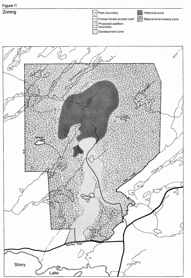
Park zoning
Park values are recognized by zoning designations and protected by the policies appropriate to each zone. The zones to be used in this historical park include an historical zone, natural environment zone and development zone (Figure 11). The nature reserve zone designation has not been incorporated into the master plan basically because there are no areas yet determined within the park boundary which will satisfy the criteria for this designation.
Figure 11: Zoning
Enlarge this zoning map of Petroglyphs Provincial Park (PDF)
Development zone
The development zone is a linear, north-south area which provides access to the historical zone, but also functions as the recreation area providing day-use and picnicking facilities.
The primary intention of the development zone is to enhance a visitor’s experience by properly directing and controlling the flow of vehicles through a quiet natural setting to and from the parking lot to the visitor services centre and the petroglyphs site. This area is the most suitable for sustaining development. The zone designation will ensure that development, operation and maintenance of the administration’s public services and facilities adhere to the appropriate management guidelines.
There is a small, narrow corridor east of the main portion of the zone that includes the existing access road for the park. However, this road will be closed after implementation of the development plan and the construction of the new entrance.
Subsequently, this zone will allow for the development, operation and maintenance of overhead hydro and telephone lines in such a manner not to be visible to the public.
Natural environment zone
The area surrounding the historical zone and development zone is designated as a natural environment zone. This zone will provide a visual and auditory buffer. Appropriate management guidelines will be provided to control activities and facilities in the zone. The natural environment zone will provide for extensive types of recreational activities, such as hiking, which require only simple man-made facilities. Resource management will be limited, permitting only those management practices required to control water levels, forest fires, severe insect infestations and over-population by deer and beaver.
Historical zone
An area of approximately 143 ha, containing the primary and secondary petroglyphs sites, has been designated as an historical zone. This area is large enough to manage effectively the nationally significant historical resource. As it encompasses the largest percentage of open rock, it probably incorporates any petroglyphs sites as yet undiscovered. The primary objective of this zone is to ensure that management guidelines exist to protect and preserve the site and permit controlled archaeological research and educational and cultural activities.
Development
The underlying theme influencing the planning and development of facilities and services in the park is that the petroglyphs site has and will continue to be considered a sacred, holy place. The subtle approach to the location, design and construction of all public facilities and services will reflect the concern for the physical protection, preservation and interpretation of the site.
The park will operate on an extended seasonal basis from April 15 to November 30. It is felt that extending the season in such a manner will give school groups a better opportunity to visit the park. Major winterization of facilities will not be necessary.
Overnight camping
The specified goal for the park does not lend itself to camping. In addition, the terrain is not conducive to campsite construction. The main visitor experience comes from appreciating the scenic, mystic and historical attributes of the carvings and the site. Most visitors will be able to view the site and complete the interpretation program in a period of one to three hours. An adequate variety of accommodations exists in various forms within a 48-km radius of the park, should the need arise. Therefore, no provision for camping will be made in this park.
Boundary extension
To complete the proposed development scheme, additional land must be acquired (Figure 12). This will provide the necessary linkage between the park area and the Northey Road. It will also provide the area required to develop the proper entrance road alignment. The development zone will be extended to incorporate this land addition once it is acquired.
Access and road system
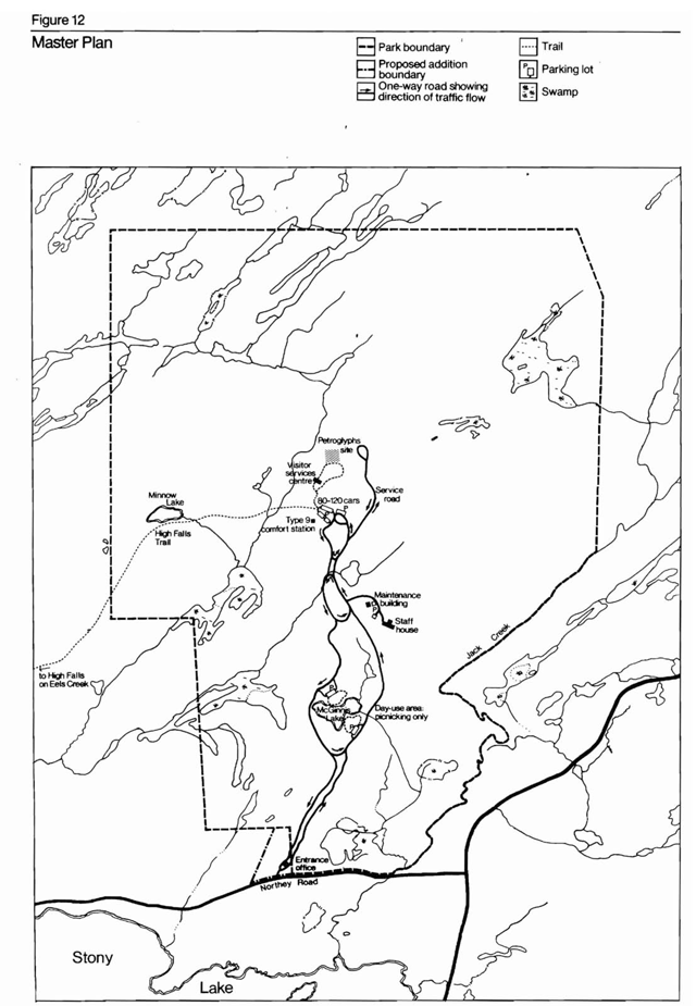
Traffic flow and circulation
The main entrance and park sign will be located just off of Northey’s Road along the southern boundary of the park (Figure 12). Upon receiving a daily vehicle permit at the entrance office, the visitor may proceed along a narrow one-way road system to the main parking lot inside the park. The visitor has the option of stopping at a day-use picnic area located on the east side of McGinnis Lake, approximately 1.5 km from the entrance. Upon reaching the main parking lot, the visitor can walk along the High Falls Trail or proceed on foot to the visitor services centre and then to the petroglyphs site. Washroom facilities are provided near the parking lot.
When leaving the main parking lot by car, the visitor will follow a narrow one-way road leading back to the entrance office. The visitor may visit another day-use area located on the west side of McGinnis Lake.
Figure 12: Masterplan
Enlarge this master plan map for Petroglyphs Provincial Park (PDF)
Entrance and control office
The entrance and control office will be located approximately 152 m inside the park from the main entrance. It will be on an island with proper turn-around circles which will accommodate visitors being turned away or wanting to return to the park. The office will act as a control gate and will also sell day-use permits. It will also function as a preliminary information centre where park staff will hand out initial information brochures and maps.
The entrance control office will be developed according to the following criteria:
- Entrance control office will be a modified Type 3 entrance and control office.
- All service lines, such as hydro and telephone lines, will be underground.
- The office will be serviced by a drilled well.
Roads
The road system will be designed and built as a narrow, twisty, scenic one-way route designed to create a tunnel effect. This design will reduce vehicle speed and noise. It will also encourage a visitor to feel that he is heading into a special, isolated place, a retreat from the cities, towns and highways.
The width of the road system and visibility on curves will be influenced by safe vehicle operating conditions. The road system will be developed in accordance with the following design criteria:
- A one-way road system will be developed with a 4.88 m right-of-way and 3.66 m hard surface.
- vegetation will be allowed to grow to the edge of the road system.
- The road surface will be smooth and hard in order to reduce noise and control dust.
- The one-way road system will pass on the east and west sides of McGinnis Lake.
- Strategically located one-way roads will join the one-way road system, forming loops to allow better traffic flow in the park.
- The main road system will not be built any closer than 300 m to 460 m of the glyphs site, leaving a buffer area between the road and the glyphs site.
- A portion of the existing road which terminates adjacent to the glyphs will remain open for maintenance purposes only.
- The existing park access road, from the Stony Lake Road to its junction with the one-way road system, will be closed and replanted.
Main parking lot
The main parking lot to be located some 365.8 m from the glyphs site will, initially, provide parking space for 80 vehicles. Parking facilities for three buses will also be provided. The parking lot will be divided into two 40-vehicle units. Both of these units will be expanded to accommodate a maximum of 60 vehicles when use patterns warrant such an expansion. The main parking lot will be developed according to the following design criteria:
- Natural vegetation will remain between the parking lot units to reduce the disturbing visual impact.
- The parking surface will be hard and smooth in order to reduce noise and control dust.
Day-use areas
Two small day-use areas are planned for McGinnis Lake, one on the east side of the lake, accessible en route to the petroglyphs site and one on the west side of the lake, accessible en route from the petroglyphs site to the entrance office. Both day-use areas will be developed for extensive types of recreational activities, such as picnicking, viewing, photography, etc. Recreational activities on McGinnis Lake, such as fishing and canoeing, will not be promoted because of the lake’s fragility.
Both day-use areas should be built simultaneously, because having both areas in operation will decrease traffic circulation within the park. Visitors, upon entering the park, may wish to have lunch before proceeding to the glyphs site. They will be able to stop at the day-use area on the east side of the McGinnis Lake. Visitors wishing to have lunch or wanting to rest after visiting the glyphs site may do so by stopping at the day-use area on the west of the McGinnis Lake. The day-use areas will be developed in accordance with the following design criteria:
- Each day-use area will contain a small parking lot capable of accommodating 30 cars.
- Each day use area will have a short scenic trail from the parking lot to McGinnis Lake.
- Each day-use area will be serviced by two vault toilets.
- Some barbecue stands will be placed in both areas.
Visitor services centre
The visitor services centre will be designed specifically as a low profile facility which will blend in with the surroundings. The facility will consist of an information booth, a lobby, an exhibit room, a theatre, a resource library, archives, working space for interpreters and washrooms for the staff.
The centre will be located between the petroglyphs site and the main parking lot, approximately 180 m from the glyphs site and 300m from the main parking lot.
Visitors will enter the building through the lobby and leave by way of the theatre. The specific aims of the centre are to make the visitor more aware of the history of the glyphs site, orient him to the culture of the Indians who carved the figures and develop a better understanding of the glyphs site before the visitor actually sees it.
The visitor services centre will be designed on the basis of the following criteria:
- The building dimensions should be as follows:
- Total area: 210-225 sq. m
- Lobby: 14 sq. m
- Exhibit room: 75-93 sq. m
- Theatre and projection room: 37 sq. m
- Resource library and archives: 28 sq. m
- Working space: 37 sq. m
- Information booth: 10 sq. m
- Washrooms: 10 sq. m
- The building should be constructed on a modular design so that additional facilities can be added if the demand arises.
- All service lines, including water and sewage lines, will be located on the ground in as inconspicuous a location as possible capped with concrete and covered with natural materials.
- The building should be heated during the winter at 10º C to protect the books, displays and collection.
- The building entrance should be placed in as convenient a location as possible for the visitor walking to the glyphs.
- The theatre will seat a maximum of 40 people. This will limit the size of the group visiting the glyphs site at any one
Petroglyphs site access
The road presently providing access to the petroglyphs site will be closed to public traffic. It will serve strictly as a service road and as a transport road for senior citizens and the handicapped.
The section of the outer fence through which visitors must pass to get to the site will be removed during the operating season. The inner fence presently around the main petroglyphs site will be removed and replaced by a portable fence enclosing the carvings presently outside the inner fence. This fence will be removed during the operating season.
Walk-in access to the petroglyphs site will be provided and controlled by the trail-boardwalk system. The trail leaving the interpretive centre will be designed to simulate the environment of the carvers.
In the immediate vicinity of the main glyphs site, the trail will continue on the raised boardwalk. It will be in a horseshoe shape around the greatest concentration of glyphs. This will enable visitors to look out over the glyphs while discouraging them from leaving the trail. The glyphs at this site will remain coloured with wax colouring to make them readily visible. Plaques placed on the boardwalk railing will be used to identify and indicate the possible meaning and significance of individual glyphs.
North of the main glyphs site, the walkway will pass close to several glyphs located in the vicinity of the present parking lot. These glyphs will have wax, dye or charcoal colouring removed from them and will be left uncoloured. The exact location of these glyphs will not be readily apparent. The general area of the glyphs will be indicated only by vegetation screens. Therefore, visitors will be able to experience the sensation of discovering petroglyphs just as the geologist did in 1954. The boardwalk present in this vicinity will discourage people from leaving the trail and damaging the glyphs. From here the trail will loop back towards the interpretive centre.
Where the trail returns to the interpretive centre, the visitor will be presented with the options of by-passing the centre to return to his car, re-entering the centre to ask for further information or viewing the exhibits once more.
Developments in the petroglyphs site area will be in accordance with the following design criteria:
- The boardwalk to be situated around the glyphs site will be wooden, horseshoe-shaped, 1.2 m wide and elevated at least 76 cm above the ground.
- The length of outer fencing to be removed will hide the fencing from the visitor’s view.
- Walkways and other structures will be stained to duplicate the grey marble colours.
Hiking trails
The High Falls Trail will be maintained to provide an auxiliary recreational activity. The use and maintenance of the existing Petroglyph Trail will be discontinued. If, in the future, there is sufficient demand for hiking trails, the existing Petroglyph Trail will be re-opened, provided a portion of the trail is re-routed northwest of the swamp and around the administration and maintenance area. If future demand exists, the trail could also be constructed using the existing Jack’s Creek crossing.
All trails will be developed in accordance with the following design criteria:
- Markings for the trail will utilize the methods of the Indians, such as cairns.
- Any interest points along the trail will be marked by numbered plaques supported on a rock cairn. The number would correspond to information in a trail brochure. Rock cairns, rather than wooden posts, will reduce vandalism and improve maintenance.
- Wood chips will be used in areas along the trail prone to erosion or root and ground compaction.
- The High Falls Trail will be a self-guided facility.
Comfort station
A Type 9 comfort station will be located adjacent to the main parking lot. It will be equally accessible from both parking lot units.
The comfort station will be constructed according to the following design criteria:
- The comfort station will provide facilities for paraplegics.
- A drilled well will provide water for this facility.
- It will be serviced by a tile bed sewage system.
- All service lines will be buried, if possible, or located on the ground in an inconspicuous area, capped with concrete and covered with natural material.
Maintenance complex
The maintenance complex which is removed from the public view does not need to follow the architectural theme guidelines for public facilities in the park. The maintenance complex will consist of a pre-fabricated, 10-man staff house and a standard two-bay maintenance building, which will include the office for the park superintendent. One main tile bed will service both the staff quarters and maintenance building. A drilled well will service both facilities. Overhead hydro and telephone lines will service the maintenance complex, but they should not be visible to the public areas.
Architecture
All buildings and structures with which the public will come into contact will be designed in keeping with the park theme. These buildings and structures include: road signs, entrance sign, entrance structures, comfort station, visitor services centre and the interpretive boardwalk trail.
Service facilities
Water supply
Water will be provided at the administration and maintenance area, visitor services centre, comfort station, picnic areas arid the main gate. Preferably, this would be_ provided from wells using a small, central pumping station and chlorinator. Since the park will not be operating during the winter season, water lines need only be buried at road and trail crossings.
Hydro supply
It is recommended that the hydro supply be brought into the park from the power line on County Road No. 6. Overhead lines will be used in the development corridor of the development zone. From the junction, hydro lines for the administration and maintenance area, pumping station and visitor services centre will run underground.
Communications
Both telephone and radio communications will be provided. Telephone service could be provided in conjunction with hydro lines and cables.
Visitor services
A high quality, major activity visitor services program about the Algonkian-speaking Indian culture will be implemented at Petroglyphs Provincial Park.
Provincial function
Petroglyphs Provincial Park will play an important role within the system of parks and facilities operated by the Ontario Ministry of Natural Resources and other agencies in interpreting Ontario’s native cultures. For example, evidence of the Algonkian culture at Petroglyphs can be compared to evidence of Ojibwa cultures at Bon Echo Provincial Park and Serpent Mounds Provincial Park, to local archaeological sites at Quackenbush Cave and Warsaw Caves and to the Huron culture at Ste. Marie Among The Hurons. Rock art at Petroglyphs can be compared to other rock art sites in provincial parks, such as Missinabi, Quetico, Lake Superior and Bon Echo. Interpretive programs explaining the relationship of the features would produce a more interesting visitor services program. Although the theme of Petroglyphs is provincial in scope, for administrative purposes Petroglyphs Provincial Park visitor services program will be a satellite of the Algonquin Provincial Park nodal visitor services program.
Park theme: “Algonkian Indian Culture”
Within the context of the Algonquin Highlands recreation landscape unit, Petroglyphs Provincial Park will relate the story of how the Algonkian native culture adapted to the rugged Canadian Shield country. The theme can be expanded to provide an overview of the cultural (i.e. social organization, settlement patterns, subsistence patterns, trade, transportation and technology) and, more specifically, the religious world of the Algonkians. The rock art site will illustrate the concept of shamans, the site as a sacred place and the carvings as expressions of art and religion.
Level of service
Major activity program
A park visitor services program will be provided year-round, with on-site park interpretation during the eight snow-free months. In order to provide a service to the public and to provide security for the carvings, a complement superintendent visitor services programmer is required. Seasonal staff for visitor services, gate duty and maintenance will be employed as needed.
A visitor centre will be required to prepare visitors for viewing the petroglyphs. By means of displays, audio-visual programs, park staff information and a park library, visitors will be provided with information to achieve an understanding of the site’s significance.
At the site of the rock carvings, an elevated boardwalk will provide the visitor with an unobstructed view of the glyphs while protecting the site from damage.
Self-use facilities will be limited to the self-guided High Falls Trail.
Visitor services program components
Communications
An appropriate communications program will be developed to provide all visitors with high quality information on the park (i.e. location, services, resources and relationship to other parks in the park system) and local attractions and services. Through a park leaflet, informed park staff and notice boards at the park gate and visitor centre this information will be available to every visitor.
The effectiveness of the communications program will be measured by the number of park leaflets handed out, the number of visitor contacts and the quality of the communications program.
Interpretive component
A high quality interpretive program will be provided to enable all visitors to understand and appreciate the Algonkian culture, in general, and in particular, the meaning of the petroglyphs. This will be achieved through the park’s design and through presentations involving various media techniques, park staff and self-use facilities.
The visitor’s awareness of the significance of the park and its cultural resources will begin at the entrance with the distinctive park sign and will be heightened by conversations with informed park staff, an informative park leaflet and the drive along the parkway. The awareness and appreciation will be further developed at the visitor centre. Information on the Algonkian culture and the petroglyphs will be presented in displays, an audio-visual program, a petroglyphs brochure and the reading and reference room. The information will be augmented by the visitor services staff.
The visitor may then walk to the glyphs site to view the rock carvings, and a roving visitor services staff member will answer any questions.
When returning from the site, the visitor can re-enter the visitor centre for additional information or return to the parking lot. At the parking lot, the visitor may choose to hike the High Falls Trail. A trail brochure available at the trail entrance will explain the relationship of Algonkian man to the land.
The success of these facilities will be measured by visitor comments, staff suggestions, the number of visitor contacts and the quality of the program.
Outdoor education
An outdoor education program will be developed to provide assistance to educational groups in understanding the park and its cultural resources. Educational groups will have an experience similar to that of the general public. The only differences will be in the arrangements made before arriving at the park, the information package received before the arrival and the special arrangements made for lectures, demonstrations, tours and use of the park library. The success of this program will be measured by the number of educational groups using the park, the student and teacher comments and the quality of the program.
Outdoor recreation
No recreational programming will be available in the park.
Research
Research into the native cultures of the Petroglyphs Provincial Park area will be continued in order to provide more information for use in programs here and throughout Ontario. Research will be conducted by park staff, Ministry staff, the staff of other parks in the area and academic researchers.
The quality of this program will be measured by the type of information added to the park files and by the improvement in the quality of the program.
Maintenance and management
Development zone
The vegetation and landform management strategy for this zone will be directed towards preserving the natural landscape, maintaining a natural, developing forest and providing a suitable environmental and aesthetic setting for the activities planned within each area of the zone.
Landscaping of buildings, parking lots and roads will use species indigenous to this region of Ontario. Landscaping will endeavour to complement the natural setting as much as possible.
Grooming the roadsides of both the main road system and the secondary road loops will be limited to hazard areas and designated stopping areas. Otherwise, the natural vegetation cover will be maintained to the edge of the road.
The zone’s existing vegetation cover will be maintained to give the impression of a natural environment. If future studies provide information about what type of vegetation actually grew in this area during the time when the carvings were done, the original vegetation will be simulated, if possible.
The two proposed day-use areas will be exceptions to the management strategies mentioned above. The picnic areas should have a park-like setting with very little undergrowth within a few small openings in the forest cover.
Natural Environment Zone
The existing mixture of species in the vegetation cover will remain unchanged unless future studies provide information about what type of vegetation grew at the time when the carvings were made. Other continuing management practices include control of water levels and the protection of forests from fire, severe insect infestation and the overpopulation of deer. No resource extraction will be permitted.
Along hiking trails, where soil compaction is prevalent, trails will be maintained by using wood chips. Dead trees and limbs which could cause injury to visitors using the trail will be removed.
Historical Zone
In the historical zone the management strategy will be directed towards preserving the petroglyphs in their present state and within a natural setting. If future research reveals what type of vegetation existed when the glyphs were carved, efforts will be made to simulate the previous vegetation cover if possible.
Monitoring and research will be continued in order to provide the safest and most effective way of protecting the glyphs site from natural erosion and lichen growth.
The fence enclosing the 4-ha area which includes the glyphs site will be maintained out of sight of the visitors. The thick understory, which presently acts as a good visual buffer, will be maintained. The section of fence through which the trail to the glyphs site passes will be removed during the operating season. A visual buffer of vegetation is needed here also.
Special management programs
Trapping
Two trapping licences have been in existence in the park area since 1970. As the present licencees are native peoples, it is proposed that they be allowed to continue trapping until such time as they wish to transfer or give up their licences. At that time, the parts of the trapping licences included within the park boundary will be deleted. Should wildlife population controls become necessary, appropriate measures will be carried out by the Ministry.
Snowmobiles and all-terrain vehicles
The use of snowmobiles and all-terrain vehicles is not compatible with the park goal and objectives. In addition, the use of these vehicles could cause damage to the park’s archaeological resources. However, there is a large number of snowmobiles (up to 100 machines on a peak day) presently using the existing forest access road in the northern portion of the park. Recently, an attempt has been made to locate an alternative route outside the park boundary. If, after monitoring the activity, this route does not prove useful, then a snowmobile trail corridor will be accommodated in the northern and eastern portions of the natural environment zone.
Deer range management
Portions of the park have been managed for deer range improvement. In keeping with the policy outlined for historical parks, no further deer range management activities will be conducted within the park boundaries. However, this management practice will be subject to review after the regional biologist has had sufficient time to study the deer range conditions in the Crown game preserve.
Hunting
Controlled archery hunting will be permitted within the natural environment zone in Petroglyphs Provincial Park. This activity will help; in a small way, to regulate the deer population. This type of hunting will also increase the visitor’s appreciation of how the Indians who carved the glyphs hunted for food. The hunting season will coincide with the hunting season outside the park.
Vegetation management
There are certain management techniques which must be applied to maintain a particular kind and quality of vegetation in a given area or zone in the park. From the descriptions of the vegetation cover desired in each zone, as described earlier, a forester will be able to formulate the vegetation management plan for the entire park to provide directions to achieve the desired vegetative quality.
Some management practices (i.e. dead and selective tree removal) will produce wood by-products. This wood can be used for firewood, saw logs, posts, etc., depending on the type and quality of the wood. This could eventually lead to money savings in both maintenance and capital costs. However, it should be remembered that the main purpose of these management practices is to maintain the quality of vegetation and not to generate revenue.
Cost estimates and phasing
Cost estimates
The following list contains the necessary projects to complete the park’s development. The costs are in 1976 dollars:
- Road construction (after completion) (this includes completing the road link with Northey Road, the turning lane on Northey Road, possible bridge or causeway construction and the resurfacing of the completed portion of the road): $75,000
- Entrance and control office: $13,000
- Hydro supply (to be completed): $15,000
- Water supply (to be completed): $25,000
- Hiking trail realignment: $2,500
- Comfort station: $30,000
- Boardwalk system (glyphs site): $6,000
- Interpretive trail: $5,000
- Day-use areas (two): $12,000
- Entrance sign: $3,500
- Communication system (telephone): $5,000
- Visitor centre (displays included): $250,000
- Sub-total: $442,000
The following is a list of the costs incurred from the existing development projects, estimated in 1976 dollars:
- Road construction (partial completion): $67,000
- Warehouse and maintenance (completed): $28,500
- Hydro supply (completed): $21,000
- Main parking lot (80 cars) (completed): $12,000
- Water supply (completed): $14,500
- Staff house (completed): $42,000
- Sub-total: $185,000
- Total Cost for Park Development: $627,000
Phasing program
The Petroglyphs Provincial Park development plan has been phased out over five stages.
Phase 1
- Road construction: $75,000
- Phase 1 sub-total: $75,000
Phase 2
- Entrance and control office: $13,000
- Hydro supply: $15,000
- Boardwalk system at glyphs site: $6,000
- Interpretive trail: $5,000
- Water supply: $25,000
- Comfort station (partial construction): $15,000
- Phase 2 sub-total: $79,000
Phase 3
- Comfort Station (completion of construction): $15,000
- Day-use areas: $12,000
- Entrance Sign: $3,500
- Hiking trail realignment: $2,500
- Visitor centre (partial construction): $50,000
- Phase 3 sub-total: $83,000
Phase 4
- Visitor services centre (partial construction) $100,000
- Phase 4 sub-total: $100,000
Phase 5
- Visitor services centre (completion of construction): $100,000
- Communications system: $5,000
- Phase 5 sub-total: $105,000
- Total of all 5 phases: $442,000
Staff requirements
The park will operate for seven to eight months a year, depending on the beginning and end of winter snowfall in a particular year. The park will operate seven days a week from mid-June until Labour Day weekend. The remaining portion of the operating season will run on a weekend and appointment-only basis.
The park will have a permanent superintendent. The park’s historical importance and significance warrant such a position. The superintendent will act as an administrator, interpreter and researcher. This person will spend the summer months acting as an administrator. In the spring and fall, he will act as an interpreter-administrator and at times when the park is officially closed, he will act as a researcher for special projects or studies. Some possible projects could include the study of various methods of protecting the petroglyphs site from weathering and the interpretation of the petroglyphs story in local school talks.
After the park is fully developed, during the peak operating season from June until September (Labour Day), there will be three interpreters on duty from 10:00 a.m. until 8:00 p.m., seven days a week. This means that a total of five seasonal interpreters will be needed to manage such a program.
A staff of three maintenance people will be required from the first of May until the first of October to maintain the park in good running order. Only one maintenance person is needed for the remainder of the operating season.
Gate staff will be necessary only during the peak operating season. The gate will be manned from 10:00 a.m. until 8 00 p.m. each day. The park entrance gate will be closed and locked during the remaining hours.
References
Canada-Ontario-Rideau-Trent-Severn Study Committee. Yesterday, Today, Tomorrow: Rideau-Trent-Severn Recreational Development Study, 1971.
Cleland, C.E. “The Prehistoric Animal Ecology and Ethnozoology of the Upper Great Lakes Region.” Anthropological Papers, No. 29. Museum of Anthropology, Ann Arbor, University of Michigan, 1966.
Coatsworth, E.S. The Indians of Quetico. Toronto, University of Toronto Press, 1957.
Dewdney, S and K.E. Kidd. Indian Rock Paintings of the Great Lakes. Toronto, University of Toronto Press, 1967.
Dewdney, S. “Ecological Notes on the Ojibwa Shaman Artist.” Arts Canada, Vol. 27, No. 4, 1970.
Eardley, A.J. Structural Geology of North America. New York, Harper, 1962.
Grant, Campbell. Some Major California and Arizona Rock Art Areas. Preceeding from The Second National Conference of Canadian Rock Art Research Associated, Saskatoon, December 3-5, 1971.
Ontario Department of Agriculture and Food. The Climate of Ontario. Publication 552, Toronto, Queen’s Printer, 1966.
Ontario Ministry of Industry and Tourism. Ontario Accommodation Guide. Toronto, Queen’s Printer, 1976.
Ontario Ministry of Industry and Tourism. Ontario Campsites. Toronto, Queen’s Printer, 1976.
Ontario Ministry of Transportation and Communication, Department of Highways, Traffic and Planning Studies Office, Planning Branch. Peterborough Area Highway Planning Study. Toronto, Queen’s Printer, 1970.
Royal Society of Canada, R.F. Legget, ed. Soils in Canada. Special Publications No.3, University of Toronto Press, 1961.
Royal Society of Canada. The Tectonics of the Canadian Shield. Special Publication No. 4,1962.
Sweetman, P.W. “A Preliminary Report on the Peterborough Petroglyphs.” Ontario History, Vol. XLVII No. 3, 1955.
Vastokas, Joan M. and Romas K. Sacred Art of the Algonkians—A Study of the Peterborough Petroglyphs. Peterborough, Monsart Press, 1973.
Vastokas, R.K. A Re-study of the Peterborough Petroglyphs—Interim Report. Research paper, 1967.