Pinery Provincial Park Management Plan Amendment
The amendment provides direction around managing the water level within the lower portion of the Old Ausable Channel (OAC). Specifically, the water level will be managed via installation of a water control structure within the Burley Causeway culvert, to maintain habitat for a number of species, including species at risk, and to enhance recreation opportunities.
Examination and adjustment of management direction
| Approval Date | Examination or Type of Adjustment | Examination Outcome (where applicable) | Link to Document |
|---|---|---|---|
| March 25, 1994 | Amendment | N/A | N/A |
| October 4, 1995 | Amendment | N/A | N/A |
| May, 1998 | Amendment | N/A | N/A |
| June 8, 2012 | Examination | Administrative update and amendment | N/A |
| July 2, 2014 | Amendment | N/A | N/A |
Amendment approval statement
July 2, 2014
Dear Sir or Madam:
I am pleased to approve this amendment to The Pinery Provincial Park Management Plan. The amendment provides direction around managing the water level within the lower portion of the Old Ausable Channel (OAC). Specifically, the water level within the lower portion of the OAC will be managed, via installation of a water control structure within the Burley Causeway culvert, to maintain habitat for a number of species, including species at risk, and to enhance recreation opportunities.
I would like to express my appreciation to all those who participated in the planning process.
Sincerely,
Bradley Fauteux
Managing Director
Ontario Parks
Approval statement
Pinery Provincial Park is set in one of the largest remaining forests in southwestern Ontario. It is full of contrasts, from its lush oak-pine forest to the undulating sand dunes which sweep down to the shore of Lake Huron. A park for all seasons, Pinery offers a variety of outdoor recreational opportunities year round in a unique natural setting.
We are pleased to approve the Pinery Provincial Park Management Plan, as official policy for the management and development of this park. The plan reflects this ministry’s intent to protect the natural and cultural features of Pinery and maintain high quality opportunities for outdoor recreation and heritage appreciation for both the residents of Ontario and visitors to the province.
Dennis W. Schafer
Regional Director
Southwestern Region
Norm R. Richards
Director
Parks & Recreational Areas Branch
Introduction
Pinery Provincial Park, 2532.5 hectares in size, is located on the southeast shore of Lake Huron in Bosanquet Township, Lambton County, approximately 6 kilometres south of Grand Bend on Highway No. 21 (Figure 1). Established on October 11, 1957, followed by several years of development, the park was officially opened in 1959.
Figure 1 - Regional Context
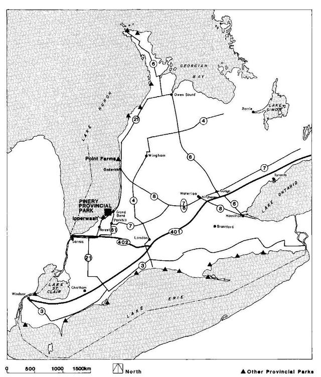
The map above is of southern Ontario showing Pinery Provincial Park, on the southeast short of Lake Huron.
Enlarge Figure 1 - Regional Context map
Many natural features that are significant on a provincial and national level, are represented in Pinery. The landscape of the area is dominated by a series of sand dune ridges and interdunal depressions with the entire site being bisected by the Old Ausable River channel and floodplain. An active process of dune building still occurs today in areas adjacent to Lake Huron. The undulating sand slopes are typical of coastal dune systems with thin, poorly developed soils. Extremely dry conditions usually persist. The park is located in the Southern Deciduous Forest Region. Many species of flora with prairie and shoreline affinities are present.
Pinery, with its significant natural environment, 9 kilometres of beach and 1000 campsites, is part of the valued recreational corridor from the Sarnia area to Grand Bend. This corridor has a concentration of year round facilities and draws heavy use by residents of both Ontario and the United States.
Pinery is a popular spot as a vacation destination and as a local day-use area. The park provides a significant contribution to southwestern Ontario’s recreational day-use and camping needs, as well as making important contributions to the objectives for Ontario’s provincial park system. In 1984, 101,487 campers and 98,050 day-users visited the park. Nearly one out of every 20 Ontario provincial park users visits Pinery in any given year (Figure 2).
Figure 2 - Three year comparison of visitation pinery provincial park
| Year | Camper Nights | Day-users |
|---|---|---|
| 1985 | 272,814 | 122,635 |
| 1984 | 274,015 | 98,050 |
| 1983 | 249,679 | 111,076 |
The planning process for Pinery was initiated in 1967. The first preliminary plan for the park, prepared in 1971, suggested that Pinery should be managed as a recreation class park. Public review and input, a growing awareness of Pinery’s natural features and the park’s popularity with the public led the ministry to conclude that the 1971 plan was not suitable. Between 1971 and 1977, the park, its features and its recreational potential were restudied in detail. This resulted in publishing the 1977 Revised Master Plan Draft which suggested Pinery should remain a natural environment park and which provided the basis for management between 1977 and 1985. This Pinery Provincial Park Management Plan represents a refinement of the 1977 plan.
Park policies
Classification
Pinery is classified as a Natural Environment Park in recognition of its provincially significant landforms and associated natural, cultural and recreational resources.
Goal
The goal of Pinery Provincial Park is to protect an extensive, provincially significant, freshwater dune system with associated representative floral, faunal and cultural features and to provide high quality educational and recreational experiences.
Objectives
Pinery Provincial Park will contribute to the achievement of the objectives of the Wingham and
Chatham District Land Use Guidelines and the Ontario provincial park system in the following manner:
Protection
To protect provincially significant elements of the natural and cultural landscape of Ontario.
The Pinery land base is one of the largest remaining, intact coastal dune systems on the Great Lakes with an extensive floral component that includes over 50 species considered rare in Ontario or Canada. As well, significant habitat exists in Pinery for many uncommon or rare faunal species such as the eastern hognose snake, Karner blue and Olympia marble butterflies and the prairie warbler. Numerous regionally significant archaeological sites also have been found along the Old Ausable River channel. Features such as these will be protected by appropriate zoning and management.
Heritage appreciation
To provide opportunities for exploration and appreciation of the outdoor natural and cultural heritage of Ontario.
In Pinery, opportunities for individual exploration and appreciation of the park’s unique environment will be provided by a series of access routes, including interpretive and hiking trails. Opportunities to gain an appreciation of the natural and cultural environments of Pinery will be provided through visitor services programming based on the character and significance of the park.
Recreation
To provide a variety of recreational opportunities in areas of outstanding recreational potential associated with the natural environment of Ontario.
Pinery offers a diverse range of recreational opportunities. Summer season activities include camping, swimming, boating, canoeing, hiking, biking, fishing and picnicking. Other seasonal activities include cross-country skiing, skating and tobogganing. Pinery contributes significantly to the forecasted demand (recreation targets) for provincial park use in the Wingham and Chatham District Land Use Guidelines.
Camping opportunities provided will be facility based, car camping.
Tourism
To provide Ontario’s residents and out-of-province visitors with opportunities to discover and experience distinctive regions of the Province.
Pinery will provide seasonal camping opportunities and year round day-use to travellers in Ontario. Cooperation with local communities will be pursued to increase use in the oft-season spring and tall periods. Winter use of Pinery attracts enough visitors to the Pinery/Grand Bend area to support the year round operation of a number of local businesses.
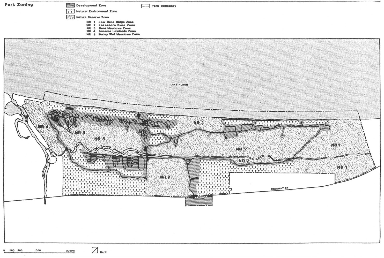
Boundary and zoning
The park boundaries are illustrated in Figure 3. Three types of zones (Nature Reserve, Natural Environment and Development) have been designated to guide the management of Pinery. These zones are summarized in Figure 3 and illustrated in Figure 4.
Figure 3 - Summary of Zoning for Nature Reserve, Natural Environment and Development
| Hectares | Percent of total area | |
|---|---|---|
| Development Zones | 684 | 27% |
| Nature Reserve Zones | 1342 | 53% |
| Natural Environment Zones | 506.5 | 20% |
Figure 4 - Park Zoning

Enlarge Figure 4 - Park Zoning map
Development zone
This zone applies to all areas of the park that have existing facilities and includes three campgrounds, three group camping areas, all roadway corridors defined by a 25 metre strip each side of all roads, all parking lots, the nine day-use areas, the park store, bicycle rental building, the wood-yard, the winter activity area, the outdoor theatre and all administrative and maintenance facilities. All intensive facility development will be confined to this zone.
Nature reserve zones
In Pinery, the best and most significant and representative landscapes have been designated as nature reserves to identify and provide long term stewardship of specific natural areas and features. Five zones provide complete representation from the Lake Huron shoreline through a series of parallel dune ridges, to Highway No. 21. This series of coastal dune ridges with their associated flora and fauna are the best remaining examples of this system in the province.
Nature reserve 1 - Low dune ridge zone
This area is made up of a provincially significant sequential series of low dune ridges (2 to 4 metres) covered with an upland dune ridge vegetation complex. These dune ridges range in age from the oldest and most inland which was formed about 6000 years ago to the youngest adjacent to the Lake Huron shoreline where the process of dune building is still occurring. This zone is bisected by the Old Ausable Channel. The lakeward section is covered by a complex of communities with the dominant community being the best representative example of mature oakpine forest found in this area of Ontario. The inland portion of this zone is covered by a low dune ridge complex of communities with the dominant community being the best representative example of open oakpine forest that has been recently exposed to burning (1964). Such fires have played a major role in shaping the development of most of the vegetative communities in Pinery. This zone also provides habitat for several species of flora and fauna considered rare in Ontario such as the eastern hognose snake, Cooper’s hawk and wandlike bush clover.
Nature reserve 2 – Lakeshore dune zone
This area is made up of a provincially significant sequential series of high, dune ridges (3 to 30 metres) which includes a geomorphological cross section of dune development tor the last 6000 years along this section of Lake Huron shoreline. The cross section includes active dune development in the open dune complex adjacent to Lake Huron as well as five parallel, stable dune ridges proceeding inland to Highway No. 21. This area is the best representative cross section of progressive dune community development in the province and includes an unforested shore dune complex, upland interdunal complex, upland dune ridge complex and unforested dune ridge complex. This nature reserve also demonstrates the dramatic effect of topography with many well developed microclimates being found throughout. Numerous species of flora and fauna considered rare in Ontario such as dwarf hackberry, Pitcher’s thistle, Olympia marble butterfly, prothonotary warbler, and prairie warbler are found in this zone.
Nature reserve 3 – Dune meadows zone
This area is made up of a provincially significant series of open dune ridges separated by extensive interdunal meadows. It is located in the central section of the park and contains dramatic variations both in microclimate and habitat types. This area is particularly noted for the large expanses of open interdunal meadows, open dune ridges, sheltered interdunal pockets and open red cedar/dwarf oak communities to name a few. This area is one of the best remaining examples of these communities in Ontario. Numerous species of flora and fauna considered rare in Ontario such as dwarf oak, dense blazing star, summer grape, chestnut yellow oak, and dwarf hackberry are found throughout this zone.
Nature reserve 4 – ausable lowlands zone
This area is made up of a provincially significant complex of communities that are the result of an extensive variety of topographic relief and moisture regimes. The highest (30 metres) actively forming dunes in the park are located adjacent to the shore of Lake Huron in this zone. Immediately inland from this ridge, the landscape plunges into a low, moist interdunal cedar complex that is one of Lambton County’s best deer wintering habitats. Next, is a series of high stable dune ridges (35 metres) and deep interdunal valleys, both heavily forested. To the west of this zone is a broad area of Ausable River floodplain covered with a mature hardwood forest containing many examples of southern species such as tulip tree, shagbark hickory and wild ginseng. Not only is this area an excellent winter foraging area for deer but also good habitat for species such as redheaded and redbellied woodpeckers.
Nature reserve 5 – Burley wet meadows zone
Within the Burley Campground are a small group of interdunal wet meadows that are of provincial and national significance. These meadows, which are scattered between the dune ridges, are influenced by a localized microclimate, the adjacent dune slopes and ground water conditions. This habitat is very uncommon in North America and found only in Canada on the section of Lake Huron shoreline between Grand Bend and Kettle Point. As well, many rare species such as bluehearts, dense blazing star, Ohio goldenrod and ram’s-head orchid are found on these sites.
The intent of management in all nature reserve zones will be to allow natural evolutionary cycles to occur. However, in the past, the elimination of fire and the creation of large plantations have severely disrupted these processes. Management will be required to reduce the effects of these disruptions before some of the communities can be returned to their more natural cycles. Many of the rare species will benefit from a return to natural cycles. The manipulation of habitat for a particular rare species can be considered in small portions of these zones after careful study. For a detailed location of these nature reserve zones refer to Figure 3.
Natural environment zones:
The remaining areas have been designated as natural environment zones. They include aesthetic landscapes with significant natural features where minimal developments are required to support lowintensity recreational activities. In Pinery, these zones have been extensively planted with conifers. Many of the planted areas now contain pines of sufficient age and numbers to have a pronounced effect on natural processes. These areas will be managed recognizing that eventual removal of the white pine is desirable (see Section Vegetation management principles).
Resource management
The park’s natural and cultural resources will be managed in accordance with the general planning and management policies for Ontario’s natural environment class parks.
Resource management plans are required to recommend specific management techniques or practices for vegetation (see Section Vegetation management principles) and dune management (see Section Landforms). In addition, monitoring of vegetative changes over time will be necessary (see Section Vegetative monitoring), and surveying of faunal populations to identify habitats of significant species is needed (see Section Fauna).
These planning, surveying and monitoring needs are interrelated. This will be recognized when undertaking these activities. Additional direction to meet the special requirements of Pinery is as follows:
Water
To enhance recreation opportunities, part of the Old Ausable Channel is dammed to maintain water at higher than normal levels. This dam is located at the causeway adjacent to the park store (see Figure 5). A second water control structure will be constructed at the Burley Bridge to maintain higher than normal water levels upstream in order to perpetuate natural values, including habitat for species at risk. This will also minimize the opportunity for invasive species to travel upstream and will further enhance recreation opportunities. The channel downstream from the Burley Bridge will be allowed to maintain its natural level. The use of outboard motors will not be permitted on any section of the Old Ausable Channel within the boundaries of the park.
All drinking water will continue to be supplied from the Lake Huron Water Treatment Plant in Grand Bend.
The need to ensure the maintenance of good water quality for the many visitors requires that drinking and bathing water in the park be monitored on a regular basis.
Figure 5 - Summer Facilities

Enlarge Figure 5 - Summer Facilities map
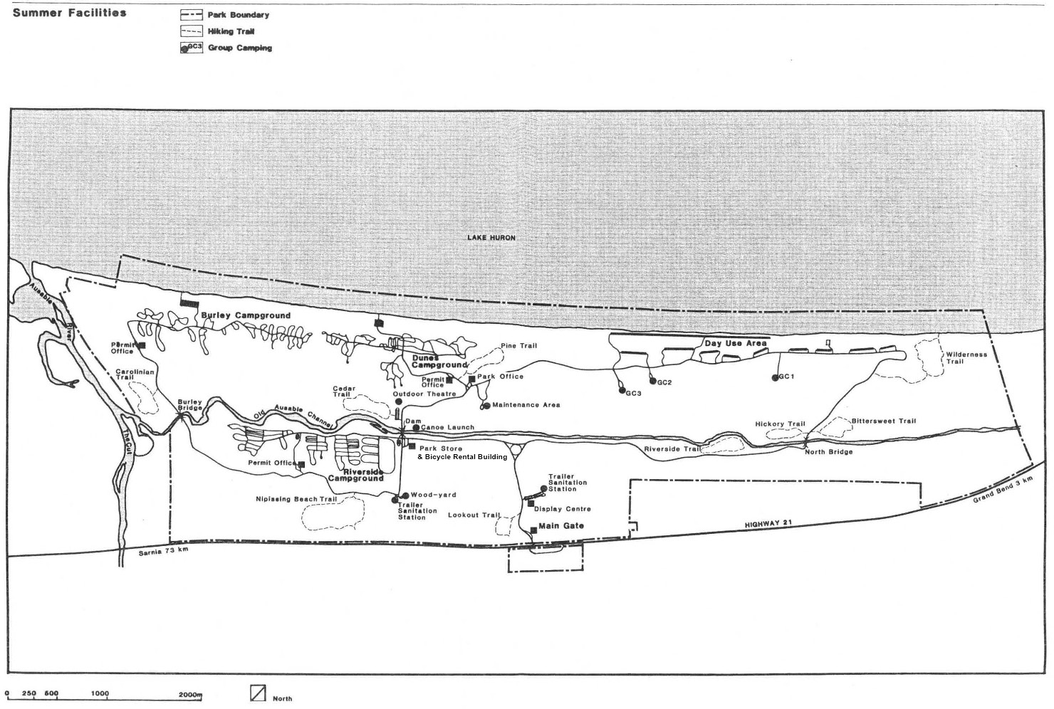
Landforms
Due to the sensitive nature of sand dunes, the stabilization and rehabilitation program introduced in recent years will continue. The program will focus on sites in areas subject to heavy use, along road cuts and adjacent to facilities in development and natural environment zones as well as sites where visitors or park development have disturbed landforms. All sand dunes in Nature Reserve Zones will be allowed to evolve naturally.
An extensive evaluation of dune protection and rehabilitation techniques is underway to determine the best methods of accommodating pedestrian traffic across dunes while minimizing impact. A sand dune management plan will be prepared.
Vegetation
Vegetation management principles
The primary vegetation management objective in the dune ecosystem is to ensure that Pinery continues to harbour the richest possible variety of naturally occurring communities inherent to its unique microclimate and topography. The emphasis will be on allowing Pinery’s flora to evolve naturally through time.
The portion of Pinery’s vegetation complex that will be allowed to evolve without man’s direct influence is zoned nature reserve (Figure 3). Within the nature reserves, the extensive conifer plantations of the 1960's must be thinned or removed. This will eliminate their potentially dominant role in the communities, thus allowing natural succession to continue.
The large conifer plantations in the natural environment zone adjacent to the Riverside Campground will be managed for their eventual removal. Removal and salvage will be subject to a vegetation management plan.
In both nature reserve and natural environment zones, special management techniques may be required for the perpetuation of rare or threatened flora and fauna. In these specific situations, emphasis will be on creating conditions favourable within the community for their continued existence. The use of fire should be considered for those species and communities that rely on it for their renewal as well as for the removal of undesirable communities such as those which are being formed by the conifer plantations.
A vegetation management plan will be prepared to recommend specific management techniques for fulfilling these vegetation management principles.
Flora extraction
The extensive conifer plantations throughout the park are a special management issue. In accordance with the vegetation management principles (see Section Vegetation management principles), the vegetation management plan may specify areas in plantations where trees need to be removed to enhance the regeneration of particular habitats or plant communities. In these areas, the trees being removed may be salvaged rather than left to decompose providing their removal from the site does not adversely affect the remaining vegetation.
Removal of plants by the general public is prohibited. Collections for ministry approved botanical or research purposes may be carried out by ministry staff or with ministry approval provided that such collections do not threaten a population’s viability.
Vegetative monitoring
Vegetative inventories will be conducted to map and quantify vegetative changes over time within both Nature Reserve and Natural Environment Zones.
Other vegetation management issues
Hazardous trees
The following policies will govern the treatment of hazardous trees.
Public Roads and Parking Lots - Hazardous trees within 25 metres from the edge of a public road or the edge of a parking lot may be felled and salvaged.
Trails - Hazardous trees that threaten the safety of trail users will be felled.
Campgrounds - Hazardous trees will be felled and salvaged.
Vegetative planting
Only indigenous species native to Pinery will be planted. Planting generally will be restricted to the heavily used portions of the Development Zone where natural regeneration methods are too slow or uncertain. Examples include buffers, shade trees, erosion control plots and ground cover in the day-use and campground areas.
The vegetation management plan will provide guidelines for planting in all zones.
Noxious weeds & introduced non-native species
Poison ivy may be controlled as required in the Development Zone or along trails for public protection. Species not native to Pinery may be controlled or eliminated where feasible by the most environmentally sound method available.
Insects and disease
lnsects and disease that attack the vegetation in the park are considered a natural element and generally are not to be controlled. However, there may be exceptions. Native insects and diseases threatening values for which the Nature Reserve and Natural Environment Zones have been established or aesthetic values of the Development Zone will be controlled where feasible. Where control is desirable, it will be directed as narrowly as possible to the specific insect so as to have minimal effects on the other components of the park’s environment. Attempts will be made to prevent insect introduction into the park and to eliminate them before they become established. Biological control will be used wherever feasible.
Chemicals
The use of chemicals will be minimized and direction for their use will be provided in a vegetation management plan.
Fire management
Prescribed burns for management purposes may be considered (see Section Vegetation management principles). All other fires will be suppressed.
Fauna
Consistent with the principles for vegetation management, the objective is to ensure that Pinery continues to harbour the richest possible variety of naturally occurring fauna. A comprehensive survey of faunal populations must be undertaken to identify significant species and habitats in the park.
Hunting will not be permitted as it conflicts with the existing year round use of the park. Trapping will not be permitted.
Nuisance animals will be removed or destroyed under the supervision of the ministry.
White-tailed deer
White-tailed deer herd reductions will be undertaken when required to protect and preserve the biodiversity of the Oak Savanna ecosystem. Partnerships may be sought and used to complete the herd reduction.
Archaeological sites
Consultation will take place between the Ministry of Natural Resources and the Ministry of Citizenship and Culture prior to the development of facilities along the river or in areas which may have archaeological value. A comprehensive analysis of these archaeological resources will be requested from the Ministry of Citizenship and Culture to enable the interpretation of this segment of Ontario’s cultural heritage to the visitors of the park.
Client services
Recreation facilities
Campgrounds
The existing number of campsites, 1075, represents full development for Pinery with a maximum of 1000 sites being operated at any one time. The remaining sites are closed on a rotating basis as part of a rehabilitation program which includes top dressing and seeding to restore the quality of the sites. The sites are divided among three campgrounds: Riverside with 474 campsites, including 126 electrical sites; Dunes, with 299 campsites; and Burley, with 302 campsites. All of these campgrounds are serviced with comfort stations, vault toilets, showers, laundromats, centralized garbage pick up, central water supply and a registration office. Services in these campgrounds may be altered from time to time to reflect the needs of park users.
Group campgrounds
Three group campgrounds containing 11 sites will be maintained adjacent to the day-use picnic areas. The users of these campgrounds will be encouraged to reduce their activities in the foredune areas to minimize the trampling that is occurring there. The fourth group campground, which was used only during the fall, winter and spring season was closed in 1985 since the natural values of the adjacent Nature Reserve Zone were being threatened by this use.
Day-use areas
The day-use areas and parking facilities require site evaluation and planning to improve public facilities and pedestrian access to the beach and, to reduce visitor impact on the vegetation. The fragile nature of the dunes in the Natural Environment Zone between the beach and parking facilities will be the subject of a sand dune management plan (see Section Landforms).
The day-use area of the park cannot be expanded without destroying portions of the dune system. This area is heavily used, sometimes to full capacity on peak weekends during the summer. The parking capacity of the day-use area is estimated to be 1100 vehicles. If the parking lots are filled to capacity the sale of daily vehicle permits will temporarily cease until parking space becomes available.
Trails
An extensive system of trails has been developed at Pinery. These trails are heavily used by visitors from May to October (58,000 users in 1985). Due to the sensitive nature of the dune system and its susceptibility to erosion, intensive annual trail maintenance is required to sustain this level of usage.
A trail management plan dealing with design guidelines, rehabilitation (dune crossings in particular) and management will be required.
Boat access
The existing access points will be maintained for the launching of small craft (canoes and car top boats). Due to the exposed nature of the Lake Huron shoreline, boaters requiring substantial launching facilities will be encouraged to use the excellent facilities at both Port Franks and Grand Bend.
Roads
Roads will be realigned where necessary to ensure safe movement of vehicles including bicycles, and to enhance the enjoyment of the park by visitors. The main areas of concern are the main gate area, the traffic circle, the park store area and several curves along the day-use road.
Cross-country ski trails
Cross-country skiing has become a major focus of the Pinery winter program. The 42 kilometres of trails (see Figure 6) receive extensive use. The present system can meet the demands of present and anticipated future use. Upgrading of certain sections of the trail is required. Local businesses are heavily dependent on this use during the winter season.
Special summer and winter facilities
These special facilities include the information and display centre and the outdoor theatre, both of which provide locations for programed activities and events for park visitors.
The information and display centre functions as a chalet serving the adjacent outdoor rink and toboggan hill which are operated during the winter. During the summer, this facility provides limited interpretation of the natural heritage of Pinery to park visitors. Currently this facility is used beyond its capacity.
The downhill ski operation was discontinued in 1978 as a result of low use and the site is now being allowed to return to its natural state.
The outdoor theatre, built in the early 1960's, needs to be replaced. Reconstruction of this facility will also permit incorporating some design changes to accommodate more innovative programing (see Section Interpretation).
The use of the once popular snowmobile trails declined to very low levels by the mid 1980's and the trails consequently have been closed.
Concessions
There are two concessions currently in the park. The park store offers groceries, basic camping supplies, light lunches and canoe and bicycle rentals. The woodyard provides fire wood for sale. These concessions will remain in their present locations.
Additional concessions may be established if required and appropriate.
Visitor services
The visitor services program will provide visitors with the opportunity to gain an understanding, awareness and appreciation for the natural and cultural resources of Pinery. As well, this program will provide visitors with information about the many varied resource management programs of the Ministry of Natural Resources. This will be achieved through the guidelines outlined in the following components.
Communications
Information concerning the park resources, management, facilities and programs, and nearby points of interest will be available at key points throughout the park. Information will be provided by a park leaflet, tabloid, signs and special publications as required. The focus will continue to be on personal contact.
Interpretation
The theme for the interpretative program at Pinery focuses on the components of the dune landscape and their associated vegetative features. The emphasis will be on the natural formation of the landforms and their use by man over time.
Interpretation will be directed towards all visitors to the park. The primary objective will be the interpretation of the physical, biological, historical and archaeological features of the park within the regional and provincial context. A variety of techniques will be used to assist the visitor in fully understanding the significant features of the park. Some will be of the self-use variety, such as displays, publications, self-guided trails and audio-visual programs. Others will be organized by staff and could include guided hikes, evening programs, special excursions and demonstrations. The interrelationship of the park’s resources, management principles and visitors will be the highlight throughout the program. Activities and programs will be dispersed throughout the park, however, the information and display centre will be the focal point for all visitors to obtain information.
Outdoor recreation
Outdoor recreation programing will focus on year round activities. Park staff will endeavour to inform visitors of the recreational opportunities in the park as well as in the surrounding areas. Special activities, such as cross-country ski lappets during the winter season and the swan viewing weekend during the spring season, will be encouraged to increase use year round (see Section Marketing).
Figure 6 - Winter Facilities

Enlarge Figure 6 - Winter Facilities map
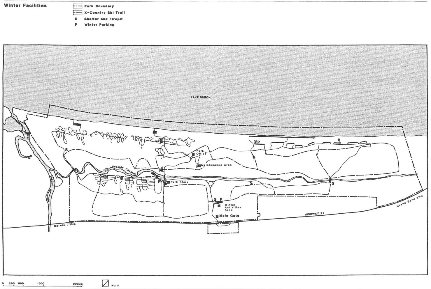
Outdoor education
The outdoor education program at Pinery will encourage school and other groups to make the best use of the park’s resources and facilities for outdoor education. Emphasis will be placed on providing the leaders with the information necessary to conduct successful outings in the park and to take an active role in park management programs.
Research
Research will be encouraged to gain a greater understanding of the natural and cultural values of the park. Recreation research will also be encouraged to evaluate the suitability of present programs, the satisfaction of park visitors and visitor activity patterns. All research will require the approval of the ministry.
Some research priorities are:
- geomorphological analysis of the landforms and their development in Pinery Provincial Park
- quantitative inventory of the fauna of Pinery Provincial Park
- analysis of visitor use in the day-use area of Pinery to determine the most appropriate means of transporting people across sand dunes with minimal impact
- analysis and interpretation of archaeological data
- analysis of the role of fire in the natural evolution of Pinery and
- surveys of visitor perceptions and expectations
Marketing
A marketing plan will be prepared with the following objectives: to attract visitors during low use periods; to increase involvement with the commercial sector by encouraging park users to take advantage of local services and attractions; and to stimulate positive interactions with the tourist and commercial operators in the area. This plan will be reviewed periodically.
Emergency service
A park emergency plan has been prepared which provides direction regarding human safety and evacuation. This plan is reviewed yearly and updated as required.
Law enforcement
The focus will be on providing a pleasurable experience for all park users and protecting the natural environment of Pinery. The emphasis therefore will be on encouraging park visitors to respect park values and other users. The enforcement program will be carried out in accordance with Ministry of Natural Resources policy, and the district and park enforcement plan.
Development principles
There are a number of existing facilities that require upgrading or relocation in order to maintain park standards and improve client services. These include the main gate area, the information and display centre, the park office including the reservation office, the area around the park store and the outdoor theatre. These matters will be reviewed according to the following principles:
- wherever possible, functions should be served by a common facility
- locations should be close to existing water and hydro corridors
- ease of access and space for parking must be considered and
- facilities must be visible to visitors
The long term objective for the information and display centre should be the replacement of the existing facility with a centre capable of meeting the programing demands being placed on it as well as being accessible to all visitors. Functional characteristics should include a year round focus for visitor service programing and public information, accommodation of a co-operating association, focus for the outdoor education users of the park, winter interpretive themes and a central point for the cross country skiers. Once established, the existing centre should be adapted for handling special day-use groups and will continue to serve the adjacent rink and toboggan hill.
Development plans will be completed and approved in advance of new development and the restoration or upgrading of existing facilities. For a listing of required development projects see Section Implementation strategy.
Pinery is one of the busiest provincial parks in Ontario. As a result, many peak periods occur when it is difficult to efficiently register the visitors. The existing registration system needs minor changes to the process as well as the facilities to improve customer service at the park entrance and campground offices.
The buildings designed as staff residences on the southeast side of Highway 21 opposite the park entrance may be removed when no longer required for park purposes.
Implementation strategy
The management plan will be reviewed once every ten years or as the need arises. Data collection and environmental monitoring will be conducted regularly.
The day to day maintenance of the park is guided by the park operating plan which will be updated as this management plan is implemented.
Projects will be undertaken as funds are available.
Development will occur according to approved site and development plans.
Future requirements identified in this plan include:
- outdoor theatre reconstruction
- administration office upgrading
- information and display centre development
- visitor registration system upgrading
- road re-alignment
- vegetation management plan
- sand dune management plan
- trail management plan
- inventory of fauna
- inventory of flora
- preparation of a marketing plan
- upgrading of day-use areas and parking facilities and
- Burley Bridge water control structure development
Selected references
Baldwin, K.A. and M.A. Maun 1983. Microenvironment of Lake Huron Sand Dunes. Can. J. Bot. 61:241-255.
Bowles, J.M. 1980. Effects of Human Disturbance on Sand Dunes at Pinery Provincial Park. Ph.D. thesis, Univ. of Western Ontario.
Cooper, A.J. and J. Clue. Quarternary Geology of the Grand Bend Parkhill Area, Southern Ontario. Toronto, Ontario Ministry of Natural Resources, Division of Mines, Preliminary Map 974 and 1065, Geological Series Scale 1:50,000, 1974.
Eldred, R.A. 1983. Effects of Environmental Factors on the Flowering of Ammophila breviligulata Fern. M.Sc. thesis, University of Western Ontario, London. 102 p.
Eldred, R.A. and M.A. Maun, 1982. A Multivariate Approach to the Problem and Decline of Vigor of Ammophila. Can. J. bot. 60(8):1372-1380.
Fox. S. 1938. T'aint Runnin No More. London.
Fox. S. 1958. ''T'aint Runnin" No More- Twenty Years After; The Story of Grand Bend, the Pinery and the Watershed of the Aux Sable River. London, 73p.
Fox, W.S. and J.H. Soper, 1952. "The Distribution of Some Trees and Shrubs of the Carolinian Zone of Southern Ontario." Transactions of the Royal Canadian Institute. Part I, 29:65-84, Toronto.
Ibid, Part II, 30:3-32, Toronto, 1953.
Ibid, Part Ill, 30:99-130, Toronto, 1954.
Gaiser, L.O. 1966. A Survey of the Vascular Plants of Lambton County, Ontario. Canadian Department of Agriculture. Hills, G.A. 1959. A Ready Reference to the Description of the Land of Ontario and its Productivity. Maple, Ontario Department of Lands and Forests.
Jury, W.W. and E.M. Jury. 1952. "The Burley Site". Ont. Hist., 44:57-75.
Krajnyk, l.S. 1979. Reproductive Biology of Ammophila breviligulata Fernald. M.Sc. thesis, University of Western Ontario, London, 164 p.
Lapierre, J.A. 1983. The Effects of Sand Burial on the Growth of Ammophila breviligulata Fern. M.Sc. thesis, University of Western Ontario, London. 130 p.
Lindsay, K.M. 1982. Rare Vascular Plants of Twelve Provincial Parks in the Deciduous Forest Region of Southern Ontario. Ont. Field Biol. (36)2: 53-70.
Maun, M.A. 1981. Seed Germination and Seedling Establishment of Calamovilfa longifolia on Lake Huron Sand Dunes. Can. J. Bot. 59:460-469.
Matthews, B.C., N.R. Richards and R.E. Wicklund. "Soil Survey of Lambton County." Ontario Soil Survey. Report No. 22, Guelph, Canada Department of Agriculture and Ontario Agricultural College.
Morrison, R.G. 1973. Primary Succession on Sand Dunes at Grand Bend, Ontario. PhD Thesis, University of Toronto.
Morrison, R. G. and G .A. Yarranton 197 4. Vegetation al Heterogeneity During a Primary Sand Dune Succession. Can. J. Bot. 52:397-410.
Mittler, P.R. A Paleoenvironmental Reconstruction of Grand Bend Bay, Lake Algonquin. M.Sc. Thesis, University of Toronto 1975.
Ontario Department of Lands and Forests, 1970. Pinery Provincial Park Inventory (unpublished report).
Ontario Department of Lands and Forests, 1971 . Pinery Provincial Park Master Plan. Toronto.
Ontario Ministry of Culture and Recreation, 1980. The Archaeology of Pinery Provincial Park: A Summary. 21 p.
Ontario Ministry of Natural Resources. Annual Reports - Pinery Provincial Park. OMNR Chatham, 1973-1983.
Ontario Ministry of Natural Resources, 1983. Chatham District Land Use Guidelines. OMNR Chatham.
Ontario Ministry of Natural Resources, 1979. Checklist of the Birds of Pinery-lpperwash Provincial Parks and Surrounding Area. Pinery Provincial Park.
Ontario Ministry of Natural Resources, 1979. Checklist of the Mammals of Pinery Provincial Park. Pinery Provincial Park.
Ontario Ministry of Natural Resources, 1979. Checklist of the Reptiles and Amphibians of Pinery Provincial Park. Pinery Provincial Park.
Ontario Ministry of Natural Resources, 1978. Ontario Provincial Parks Planning and Management Guidelines. OMNR, Parks Planning Section, Toronto.
Ontario Ministry of Natural Resources, 1974. Pinery Toward a Balance. OMNR, London, 99p.
Ontario Ministry of Natural Resources, 1975. Pinery Provincial Park: An Evaluation of the Potential for Winter Recreation. Marshall, Macklin and Monagham, Don Mills, Ontario. 46p.
Ontario Ministry of Natural Resources, 1979. Plants of Pinery. Pinery Provincial Park.
Ontario Ministry of Natural Resources, 1974. Visitors Services Plan, Southwestern Regional Provincial Parks. London.
Ontario Ministry of Natural Resources, 1983. Wingham District Landuse Guidelines. OMNR Wingham.
Payne, A.M. 1980. The Ecology and Population Dynamics of Cakile edentula var. lacustris on Lake Huron Beaches. M.Sc. thesis, University of Western Ontario, London. 193 p.
Payne, A.M. and M.A. Maun 1981. Dispersal and Floating Ability of Dimorphic Fruit Segments of Cakile edentula var. lacustris. Can. J. Bot. 59:2595-2602.
Sparling, J.H. 1965. The Sand Dunes of the Grand Bend Region of Ontario. Ontario Naturalist, March pp16-23.
Stothers, D.M. 1972. A Preliminary Report on an Archaeology Survey of Pinery Provincial Park. Toronto, Ontario Ministry of Natural Resources.
Tasker, P. 1972. The Pinery, From Park to Instant City. Ontario Naturalist, June, pp4-8.
Westelaken, l.L. 1983. Population Dynamics and Ecology of Lithospermum caroliniense (Walt.) Macmill on the Lake Huron Sand Dunes. M.Sc. thesis, University of Western Ontario, London, 160p.
Additional copies of this publication can be obtained from the Ministry of Natural Resources and Forestry:
The Pinery Provincial Park
9526 Lakeshore Road, RR#2
Grand Bend,ON N0M 1T0
MNR 62852 (Print)
MNR 62853 (PDF)
ISBN 978-1-4606-4055-5 (Print)
ISBN 978-1-4606-4056-2 (PDF)