Raganooter Lake, Big Deer Lake & Ferrie Township Forest Conservation Reserves Management Statement
This document provides policy direction for the protection, development and management of Raganooter Lake, Big Deer Lake & Ferrie Township Forest Conservation Reserves and their resources.
June 2002
Ministry of Natural Resources
Parry Sound District
Prepared with the assistance of:
Meteek & Company
Huntsville, Ontario
Approval statement
We are pleased to approve this Statement of Conservation Interest (SCI) for three conservation reserves, namely: Raganooter Lake Conservation Reserve (C77); Big Deer Lake Conservation Reserve (C78); and Ferrie Township Forest Conservation Reserve (C81).
These conservation reserves are three of 378 new protected areas approved through Ontario’s Living Legacy Land Use Strategy, a strategy aimed in part at completing Ontario’s system of parks and protected areas. All three lie within Hill’s ecological Site District 5E-8. In addition to their individual values, the three conservation reserves, together with the intervening lands of Ferrie Township, provide opportunities for tourism and recreation in a remote setting and also provide a diverse and relatively undisturbed habitat for a wide range of wildlife (including large and small game such as moose, white-tailed deer, timber wolves, grouse, and a variety of song birds).
The three sites are located in the Territorial District of Parry Sound, and all are within the Municipality of Whitestone, except the northern half of the Raganooter Lake Conservation Reserve, which is unincorporated.
Raganooter Lake Conservation Reserve (311 hectares) is the most northerly of the three conservation reserves. It is located about 22 kilometres north-west of the village of Magnetawan and 8 kilometres south of the hamlet of Golden Valley. The site extends north from Raganooter Lake, within the northern limits of Ferrie Township and the southern limits of East Mills Township. It contains old hemlock on hilly terrain with sandy soils, with some flatter sandy deposits. Three combinations of vegetation and landforms within the site provide ecological representation within the site district. The site lies within the Loring deer yard, with old-growth hemlock providing winter protection for the deer.
Big Deer Lake Conservation Reserve (436 hectares) is located about 15 kilometres north-west of the village of Magnetawan. Its southern boundaries are about 1.5 kilometres north of Big Deer Lake in eastern Ferrie Township. The upland mixed forest in this site provides ecological representation of eleven combinations of vegetation and landforms, including spruce forests growing on rolling sandy hills and bare bedrock, and balsam fir, hemlock and white birch forests on low bedrock hills.
Ferrie Township Forest Conservation Reserve (474 hectares) is located about 8.5 kilometres north-east of the hamlet of Dunchurch, and about 15 kilometres north-west of the village of Magnetawan. It provides ecological representation of a forest of white pine, tamarack and treed muskeg on a landscape of dunes and beach deposits.
During the Lands for Life planning process, the public was widely consulted and provided valuable input into what became Ontario’s Living Legacy Land Use Strategy. Comments received during that time, and during consultation related to the formal Public Lands Act regulation of the boundaries of these conservation reserves, were generally supportive of the protection of these areas. Stakeholders who provided comment during the boundary consultation for these sites were subsequently consulted regarding the draft Statement of Conservation Interest and their comments were considered in the finalization of this document.
This Statement of Conservation Interest provides guidance for the management of the three conservation reserves and the basis for the ongoing monitoring of activities. More detailed direction is not anticipated at this time. Should complex management or conservation issues arise or significant facility development or other uses be considered, then a detailed Resource Management Plan will be prepared with full public consultation.
These conservation reserves are managed under the direction of the District Manager and the Bracebridge Area Supervisor of the Ministry of Natural Resources, Parry Sound District. The northern portion of the Raganooter Lake Conservation Reserve is managed under the direction of the District Manager and the Wasi Area Supervisor of the North Bay District.
Approved by:
R.G. Griffiths
District Manager
Parry Sound District
Approved by:
G. Ross
Regional Director
Southcentral Region
1.0 Introduction
Ontario’s Living Legacy, the result of an extensive planning process that began in early 1997, culminated in the approval in July 1999 of a Land Use Strategy that identifies the intended strategic direction for Crown land, including the completion of Ontario’s system of parks and protected areas. This process, which included extensive public consultation, resulted in the recommendation for regulation of 378 new protected areas, including the three conservation reserves that are the subject of this Statement of Conservation Interest.
Conservation reserves are established by regulation under the Public Lands Act (O. Reg. 805/94). A Statement of Conservation Interest is prepared under the authority of Procedural Guideline A – Resource Management Planning (PL. Procedu re 3.03.05). These three conservation reserves were established under the authority of the Public Lands Act as follows:
- Raganooter Lake Conservation Reserve – by Ontario Regulation 86/01, April 6, 2001;
- Big Deer Lake Conservation Reserve – by Ontario Regulation 461/00, August 10, 2000; and,
- Ferrie Township Forest Conservation Reserve – by Ontario Regulation 461/00, August 10, 2000.
The purpose of this Statement of Conservation Interest (SCI) is to identify and describe the values of three conservation reserves: Raganooter Lake Conservation Reserve (C77); Big Deer Lake Conservation Reserve (C78); and Ferrie Township Forest Conservation Reserve (C81) The SCI also outlines the activities that occur within the reserves and provides guidelines for the management of current and future activities in the context of protecting the natural, recreational and cultural values.
The three conservation reserves lie in Ferrie Township within the Municipality of Whitestone (excepting a portion of Raganooter Lake Conservation Reserve which is in East Mills Township). The reserves consist entirely of Crown lands and are surrounded by Crown lands. Together, they provide ecological representation in Hills' (1959) ecological Site District 5E-8, through a variety of combinations of vegetation and landforms. Together with the surrounding Crown lands, they comprise a relatively remote area which provides opportunities for tourism and recreation in a remote setting, and a diverse and relatively undisturbed habitat for a wide range of wildlife, including large and small game such as moose, white-tailed deer, timber wolves, grouse, and a variety of song birds.
1.1 Background information
| Name | Raganooter Lake Conservation Reserve - C77 |
|---|---|
| Ecological Site Region / Site District | Georgian Bay / 5E-8 |
| OMNR Administrative Region/District/Area | Southcentral Region / Parry Sound District / Bracebridge Area; and Northeast Region / North Bay District / Wasi Area |
| Total Area (hectares) | 311 |
| Regulation Date | April 6, 2001, by Ontario Regulation 86/01 |
| First Nations | Part of Robinson – Huron Treaty Area |
| OBM map sheet | 20 17 5900 50700 |
| Topographic Map | Golden Valley 31E/13 |
| UTM Co-ordinates | 17T 595000 5078500 (Centroid) |
| Name | Big Deer Lake Conservation Reserve - C78 |
|---|---|
| Ecological Site Region / Site District | Georgian Bay / 5E-8 |
| OMNR Administrative Region/District/Area |
Southcentral Region / Parry Sound District / Bracebridge Area |
| Total Area (hectares) | 436 |
| Regulation Date | August 10, 2000, by Ontario Regulation 461/00 |
| First Nations | Part of Robinson – Huron Treaty Area |
| OBM Map Sheet | 20 17 5900 50700 |
| Topographic Maps | Golden Valley 31 E/13 |
| UTM Co-ordinates | 17T 596750 5071000 (Centroid) |
| Name | Ferrie Township Forest Conservation Reserve - C81 |
|---|---|
| Ecological Site Region / Site District | Georgian Bay / 5E-8 |
| OMNR Administrative Region/District/Area |
Southcentral Region / Parry Sound District / Bracebridge Area |
| Total Area (hectares) | 474 |
| Regulation Date | August 10, 2000, by Ontario Regulation 461/00 |
| First Nations | Part of Robinson – Huron Treaty Area |
| OBM map sheet | 20 17 5900 50600 |
| Topographic Map | Golden Valley 31E/13 |
| UTM Co-ordinates | 17T 592000 5067000 (Centroid) |
1.2 Representation/targets
Earth science representation:
Bedrock
- All three conservation reserves lie within Parry Sound Domain of the Parry Sound Terrane, in the Central Gneiss Belt of the Proterozoic Grenville Province (Easton 1992a)
The dominant rock types are:- Raganooter Lake Conservation Reserve – Raganooter meta-anorthosite;
- Big Deer Lake Conservation Reserve – felsic and mafic gneisses of the McLaren Island gneiss association: and
- Ferrie Township Forest Conservation Reserve – felsic paragneiss of the Moon Island gneiss association.
Surficial
- All three sites feature gravely sand deposits of variable depth, of glacial till origin, with soils of Monteagle Gravely Sand Complex. (Hoffman et al, 1962)
- Raganooter Lake Conservation Reserve – forested upland, minor relief, abundant bedrock outcrop
- Big Deer Lake Conservation Reserve – low relief forested area with a few large bedrock outcrops in uplands, scattered smaller outcrops on shorelines.
- Ferrie Township Forest Conservation Reserve – low relief forested area, with small outcrops scattered on shorelines and in wetlands. Ferrie Township Forest Conservation Reserve evidences reworking of glacial deposits into a landscape of dunes and beach deposits.
Life science representation:
These three conservation reserves were identified through a natural heritage gap analysis project for Site District 5E-7 and 5E-8, in conjunction with Ontario Living Legacy’s land use planning. The purpose of the gap analysis was to identify different vegetation and landform combinations that were not included in protected areas at that time. (See also Section 2.2).
- Raganooter Lake Conservation Reserve – This site features rugged steep hills with numerous protrusions of granitic bedrock, forested with an extensive stand of old-growth eastern hemlock, along with some rock barrens with scrubby growth. Valleys feature mixed forests of hemlock, white pine, yellow birch, balsam fir, red maple, white cedar, black spruce and speckled alder. Poor drainage of the lowland areas has fostered the development of peat soils. This area is a part of the Loring deer yard.
- Big Deer Lake Conservation Reserve – This site was selected as a conservation res erve owing to the presence of extensive post-glacial deposits of deep gravely sand, with extensive coniferous and early successional mixed forests.
- Ferrie Township Forest Conservation Reserve – This site provides ecological representation of forests of white pine, tamarack, and treed wetlands on a landscape of reworked glacial deposits.
Cultural resources representation:
No research has been done to date. An early colonization road passes near these three reserves, and the area is rich in logging history; however, as yet no specific values have been identified.
Recreational opportunities:
No specific field studies have been undertaken with regards to recreational opportunities in the conservation reserves. However, a recent field review indicates that the ar ea accommodates sport hunting, and some general exploring. Snowmobiling and some all-terrain vehicle use are known to occur, particularly along tertiary roads, old logging roads, and unofficial trails.
The north portion of the Raganooter Lake Conservation Reserve lies within a "limited access area" (OMNR 1983) in the MNR's North Bay District. This area has also been identified through the Ontario Living Legacy planning process as a Remote Access Enhanced Management Area (East Mills - E74a) (OMNR 1999). Big Deer Lake Conservation Reserve and Ferrie Township Forest Conservation Reserve both lie within the Ferrie Lount Remote Access Enhanced Management Area (E304a). Together, the three conservation reserves lie within an extensive area providing opportunities for tourism and recreation in a back country remote access setting, along with opportunities for resource management.
1.3 Survey work
| Survey Level | Earth Sciences | Life Sciences | Cultural | Recreational | Other |
|---|---|---|---|---|---|
| Reconnaissance | All 3 sites –Frey & Duba (2001) | All 3 sites – Blythe & McDonnell (2002); Noble (1983) | none | OMNR (2002) | |
| Detailed | none | none | none | none | |
| Requirement | None anticipated. | Further inventory needs to be assessed | Not anticipated | None anticipated. Monitor use impacts. |
2.0 Values to be protected
These conservation reserves are located entirely within Hills (1959) ecological Site District 5E-8. Values include earth science, life science and recreational/aesthetic with an emphasis on the life sciences.
2.1 Earth science
Earth science values are focused on features (bedrock and surficial) that represent the chronology of earth history in the province (Davidson, 1981).
The bedrock of the three conservation reserves is within the Parry Sound Domain, Parry Sound Terrane of the Central Gneiss Belt, in the Proterozoic Grenville Province. The Parry Sound Terrane is one of four lithotectonic terranes of the Central Gneiss Belt. Within the Parry Sound Terrane, the Parry Sound Domain is one of three structural domains. This geological environment is part of the modern organization of the complex products of the mid-Proterozoic Grenville orogenic events (Easton 1992b). As such, its representation within these three reserves contributes to the conservation of the Grenville continental accretion theme (Davidson, 1981).
Within the Parry Sound Domain, the dominant rock types of the three reserves varies as follows:
- Raganooter Lake Conservation Reserve – meta-anorthosite;
- Big Deer Lake Conservation Reserve – felsic and mafic gneisses of the McLaren Island gneiss association;
- Ferrie Township Forest Conservation Reserve – felsic paragneiss of the Moon Island gneiss association.
Significance
Raganooter Lake Conservation Reserve – From an earth science perspective, the geology of this conservation reserve has regional significance in its representation of the Raganooter meta-anorthosite of the Parry Sound Domain. (Frey & Duba 2000).
Big Deer Lake Conservation Reserve – From an earth science perspective, the geology of this conservation reserve has regional significance in its representation of the felsic and mafic gneisses of the McLaren Island gneiss association of the Parry Sound Domain. (Frey & Duba, 2000)
Ferrie Township Forest Conservation Reserve – From an earth science perspective, the geology of this conservation reserve has local to regional significance in its representation of the quartzofelspathic paragneiss of the Moon Island gneiss association of the Parry Sound Domain. (Frey & Duba 2000)
2.2 Life science
The three conservation reserves are located within Hills' (1959) ecological Site District 5E-8. The assessment of life science values is primarily focussed on landform type and the vegetation communities that occur on those landforms (Noble, 1983) within the context of a site district.
In late May 1997, the Ministry of Natural Resources (Natural Heritage Information Centre and Natural Heritage Section) carried out a natural heritage "gap analysis" project for Site District 5E-7 and 5E-8, in conjunction with Ontario Living Legacy’s Land Use Planning. The purpose of the gap analysis was to identify different vegetation and landform combinations that were not included in protected areas at that time. Geographic Information Systems technology was used and applied to the following criteria: 1) representation of landform -vegetation patterns; 2) diversity; 3) condition; 4) ecological considerations; and 5) special features (Crins and Kor 1998). These three conservation reserves were identified through this gap analysis.
Representation
Raganooter Lake Conservation Reserve – This site is situated on a moderately broken shallow sandy till uplands, with bare bedrock exposures. It is dominated by an extensive stand of old-growth hemlock, primarily on the hills. Steep valleys between the hills are forested by a mixture of hemlock, white pine, yellow birch, balsam fir, red maple, white cedar, black spruce and alder. Most low lying areas feature organic peat soils. Non-forest areas include wetlands (open and treed muskeg) and bare rock.
Big Deer Lake Conservation Reserve – Over two thirds of this site occupies a weakly broken bare bedrock plain, with patches of exposed bedrock, while most of the remainder lies on a weakly broken sandy till plain with patches of exposed bedrock. Soils are relatively deep in some parts of the reserve, and are derived from post-glacial deposits of deep gravely sand. The sub-angular nature of the cobbles and other stony material in the deposits suggests early deposition in post-glacial Lake Algonquin along an ice front. Coniferous forests predominate on well-drained upland sites, but trembling aspen and red oak are also found on these sites. Valley forests are a mixture of hemlock, yellow birch, balsam fir, red maple, white spruce, white cedar, black spruce and white birch. Organic peat soils are located in low, poorly drained areas, and generally support speckled alder thickets and graminoid meadows. The forests are mostly in an early successional state, with dense understories reflecting recent logging activity.
Ferrie Township Forest Conservation Reserve – Most of this site occupies a weakly broken sandy till plain, with bedrock outcrops, while a portion (<20%) occurs on a weakly broken bare bedrock plain, with pockets of organic soils. It provides ecological representation of a forest of white pine, tamarack, and treed wetlands on a landscape of deep gravely sand originating from reworked glacial deposits. These well drained relatively deep soils foster the growth of extensive coniferous forest in both dry upland sites and in wetland settings.
The predominant species on the upland areas of all three sites are white pine and white spruce (although trembling aspen, balsam fir and white birch are also found on the upland sites), while the lowlands have produced conifer forests of eastern white cedar, tamarack and black spruce. Recent logging activity has resulted in the removal of a significant component of the overstory under the partial cutting silvicultural harvesting systems typically employed in this area. The remaining overstory is in a middle successional stage whereas the understory is in an early successional stage and tends to be dense in response to open canopy light conditions.
Condition
Raganooter Lake Conservation Reserve – The old -growth hemlock stands do not show evidence of past logging, and may have originated as a result of a major forest disturbance such as a fire or wind throw. Evidence can be seen (stumps, some logging artefacts) of logging, perhaps in the early 1900's, along the shoreline of Raganooter Lake, and an area on the west side of the reserve (lots 6 & 7, Ferrie and East Mills townships) that was actively logged some 20 years ago.
Some past mineral exploration activity is evidenced by rock spalls from exposed bedrock and erratic boulders.
No commercial forest harvesting or mining currently occurs in the reserve.
A road passes within a kilometre of this reserve to the south, and from this, trails extend into the reserve utilizing a bridge across the Pickerel River west of Raganooter Lake. It is the MNR's intention to remove this bridge. All-terrain vehicles and snowmobiles appear to gain access to and throughout the valleys of the reserve, with some evidence of erosion and creation of mud holes in the wet areas. Trails do not yet extend into the old -growth hemlock areas, perhaps because of their location on steeper rugged terrain.
The area is used for hunting and fishing. One recreation camp is located adjacent to the southern boundary of the reserve, and fur harvesting (Registered Traplines PS 40 and NB 77) occurs within the reserve.
Big Deer Lake Conservation Reserve – Recent logging activity has occurred over most of this site, but currently neither commercial forest harvest or mining activity occur within the reserve. There has been some aggregate use for road building and repair.
A resource access road allows vehicular access to within 500 metres of the west boundary of the reserve. When this road was decommissioned after recent logging activity, the removal of a culvert rendered it closed to standard vehicles; however, the roadbed still is used by all-terrain vehicles and snowmobiles to access a network of informal trails throughout the reserve. There is evidence of erosion and the development of mud holes from this trail use.
Hunting and fur harvesting (Registered Trapline PS 41) occur within the reserve. One recreation camp is located just outside the boundary of the reserve and another is located inside the reserve on the northern side.
Ferrie Township Forest Conservation Reserve – Recent logging activity has occurred over most of this site, but currently neither commercial forest harvest or mining activity occur within the reserve.
A resource access road for traditional vehicular access approaches close to the northern boundary reserve, although it is breached (by lack of a bridge) in 2 locations, an unnamed creek and the Ferrie River. The access road, at this point very overgrown, continues on the west side of the Ferrie River but ends just before the boundary at an old landing. A faint trail which may be used by snowmobiles in the winter continues into the reserve and is shown on maps as continuing to the southwest, connecting with access roads to the south of the reserve.
Hunting and fur harvesting occur within the reserve (Registered Traplines PS 41 and PS 42). One recreation camp is located just inside the reserve boundary on the west side.
Diversity
Raganooter Lake Conservation Reserve – The relatively nutrient poor soils of this area, their low pH, and the dense forest canopy conditions associated with the old-growth eastern hemlock all serve to limit the botanical species diversity for this reserve. Given these conditions, it is unlikely that additional inventory will discover any provincially or regionally rare species. The richest areas within the reserve are the valley bottoms and associated wetlands, but these are characteristic of the area, rather than remarkable. Wildlife species found within the site are also typical of the region.
Big Deer Lake Conservation Reserve – Similar soils (low nutrient levels and low pH) also serve to limit the botanical diversity of this reserve. Additional surveys are unlikely to turn up provincially or regionally rare botanical species. Wildlife species are typical of the region, although field inventory (Blythe & Associates, 2001) encountered large numbers of timber wolf scats and tracks, and an abundance of moose activity was noted.
Ferrie Township Forest Conservation Reserve – Similar soils (low nutrient levels and low pH) also serve to limit the botanical diversity of this reserve. Additional surveys are unlikely to turn up provincially or regionally rare botanical species. Wildlife species are typical of the region. Recent site reconnaissance noted a great blue heron rookery within the reserve (Blythe & Associates, 2001). It appears to be in decline.
Ecological considerations
Raganooter Lake Conservation Reserve – The old-growth eastern hemlock portion of the reserve forms an integral part of the Loring deer yard, as indicated by signs of heavy browsing of the forest understory plants. The presence of the forest itself is a good example of a climax successional forest, which is self-perpetuating unless altered by future cataclysmic events such as fire, wind, insect epidemic or logging.
The entire reserve forms a portion of the headwaters of the Pickerel River.
Big Deer Lake Conservation Reserve – Most of the reserve has undergone extensive timber harvesting in recent past. Consequently, the overstory is in middle successional stages, with an open canopy that promotes an abundance of understory regeneration. This provides excellent browse for moose and white-tailed deer. Field reconnaissance (Blythe & Associates 2001) noted that the red maple component of the understory was heavily browsed by moose. In addition, dense immature forest growth may provide good breeding habitat for passerines.
Ferrie Township Forest Conservation Reserve – The recent history of timber harvesting creates similar situations of an overstory of middle-aged successional forests with abundant understory regeneration, providing good browse opportunities for moose and white-tailed deer, and good nesting habitat for passerines.
The three conservation reserves, being in close proximity to one another, along with the intervening and surrounding Crown lands, provide a diver se and relatively undisturbed habitat for moose, white-tailed deer and timber wolf which inhabit this remote part of the Parry Sound District.
Special features
Raganooter Lake Conservation Reserve – Old growth eastern hemlock stands. Head waters of the Pickerel River. Part of the Loring deer yard.
Big Deer Lake Conservation Reserve – Deep well drained gravely sand deposits supporting mixed forests.
Ferrie Township Forest Conservation Reserve – This conservation reserve provides confirmed nesting habitat for Great Blue Heron (Ardea herodius). Deep well drained gravely sand deposits supporting mixed forests.
Significance
The significance of these three sites must be evaluated within the context of the natural heritage gap analysis through which they were identified for protection. They contain representative portions of three different landforms and several vegetation types (based on FRI analysis). This contributes towards completed the system of protected areas within Site District 5E-8.
Raganooter Lake Conservation Reserve – This conservation reserve provides provincially significant representation of old growth eastern hemlock stands on a moderately broken shallow sandy uplands in ecological Site District 5E-8.
Big Deer Lake Conservation Reserve provides regionally significant representation of extensive coniferous and mixed forests on extensive post-glacial deposits of deep gravely sand.
Ferrie Township Forest Conservation Reserve provides regionally significant representation of a forest of white pine, tamarack and treed wetlands on a landscape of deep gravely sand originating from reworked glacial deposits.
2.3 Recreational/aesthetic values
In 1983, the Parry Sound District Land Use Guidelines recognised the value of back-country tourism and recreation in this general area by establishing an extensive Restricted Access Area, intended "to maintain an area of the Parry Sound District which provides both opportunities for recreation in a relatively remote setting and opportunities for resource extraction". (OMNR 1983 – Parry Sound); a "Limited Access Area" with similar restrictions exists for the southern part of East Mills Township in North Bay District (OMNR 1983 – North Bay). The Ontario’s Living Legacy Land Use Strategy (OMNR 1999) confirmed this direction through the designation of two Remote Access Enhanced Management Areas (E74a and E304a) for the general crown land around the three conservation reserves. This large area of Crown land and the three conservation reserves within it provide an extensive area with opportunities for tourism and recreation in a back country remote access setting.
Although no specific studies have been undertaken, the three conservation reserves are known to be used for sport hunting and some general exploring. Informal trails within all three sites are known to be used by all-terrain vehicles and snowmobiles. All-terrain vehicle use appears to be heavy, and snowmobile use is moderate in the Raganooter Lake and Big Deer Lake Conservation Reserves. All-terrain vehicle use is light in the Ferrie Township Forest Conservation Reserve. An informal snowmobile trail passes this reserve along the forest access road, and may provide occasional snowmobile use in the reserve.
Sport fishing is known to occur within lakes adjacent to the three conservation reserves, but not generally within them because of a lack of suitable water bodies.
The current and expected levels of recreational activities within these conservation reserves have local significance. Unplanned development of all-terrain vehicle trails, and their heavy use, appears to be leading to erosion problems and the creation of mud holes in low lying areas. Otherwise, with the exception of the potential for wild fire, recreational use is considered to pose little threat to the other values of these reserves.
3.0 Management guidelines
3.1 Land tenure
These three conservation reserves consist entirely of Crown land, and are surrounded by Crown land. The concession road allowances between concessions within all three conservation reserves were closed in December 1999 by Order in Council 2379/99 and so are included.
Recreation camps are located within the Ferrie Township Forest and Big Deer Lake Conservation Reserves.
All three are contained within registered trapline areas. Bear Management Areas (BMA) and Bait Harvest Areas (BHA) apply partially, as follows:
- Raganooter Lake Conservation Reserve – This reserve is included within 2 registered traplines. A BMA includes the northern (East Mills Township) portion of the reserve. The Ferrie Township portion is not contained within a BMA. The northern portion of this conservation reserve is excluded from the surrounding BHA. The southern portion is within a BHA, but is currently unassigned.
- Big Deer Lake Conservation Reserve – This reserve is included within a registered trapline. This reserve is not contained within a BMA. The area is within a BHA which is currently unassigned.
- Ferrie Township Forest Conservation Reserve – This reserve is included within 2 registered traplines. The west portion of the reserve is included within a BMA . The area is within a BHA which is currently unassigned.
Guideline
Sale of Crown lands within the conservation reserves is not permitted.
The existing recreation camps in Ferrie Township Forest and Big Deer Lake Conservation Reserves are permitted to continue. They may be eligible for enhanced tenure, but not for purchase of land. New recreation camps are not permitted.
Land tenure will continue for fur harvest through the registered trapline areas. The commercial bear hunting service associated with the current Bear Management Areas is allowed to continue. Bait Harvest Areas, which are currently unassigned, will be re -assigned to future applicants.
3.2 Existing/proposed development
Background
With the exception of the two recreation camps in the Ferrie Township Forest and Big Deer Lake Conservation Reserves, there are no existing buildings, structures, or constructed facilities known within these conservation reserves.
Big Deer Lake, Ferrie Township Forest Conservation Reserves and the Parry Sound District portion of the Raganooter Lake Conservation Reserve all lie within an extensive area designated by the Parry Sound District Land Use Guidelines as a Restricted Access Area intended "to maintain an area of the Parry Sound District which provides both opportunities for recreation in a relatively remote setting and opportunities for resource extraction". (OMNR 1983 – Parry Sound). Accordingly, public access for recreational purposes to the intervening crown lands bet ween these three conservation reserves is limited to present means of access. The portion of Raganooter Lake Conservation Reserve in East Mills Township, North Bay District is designated as within a "Limited Access Area" which has similar restrictions (OMNR 1983 – North Bay). Ontario’s Living Legacy Land Use Strategy (OMNR 1999) confirmed this direction through the designation of two Remote Access Enhanced Management Areas: Ferrie – Lount (E304a) for the Parry Sound portion of the general area; and East Mills (E74a) for the North Bay portion.
Resource access roads, currently decommissioned in keeping with these land use designations, are located near all three conservation reserves, and are generally in good condition as most have been used for timber harvesting in recent years. These roads are generally breached (by removal of key bridges or culverts) and the main access road has been gated, but in recent years, there is evidence that the public has been bypassing the gate to use these roads for recreational purposes.
There are known to be informal trails in all three conservation reserves, used in conjunction with the registered trapline areas, recreational all-terrain vehicles and snowmobiles.
Guideline
No new roads for resource extraction or private use will be permitted into or through the any of these conservation reserves.
It is the MNR's intention to remove the bridge across the Pickerel River which provides access to Raganooter Lake Conservation Reserve.
No mineral exploration is permitted within these conservation reserves. This direction is based on a commitment made by the Ministry of Natural Resources and the Ministry of Northern Development and Mines in the spring of 2002. This direction replaces that identified in the 1999 Ontario’s Living Legacy Land Use Strategy, which stated that stated that controlled mineral exploration is permitted in specific new conservation reserves that have been identified as having provincially significant mineral potential. Roads necessary for access to mining claims and leases for mineral exploration and development are permitted, with appropriate consideration for the protection of conservation reserve values.
The use of existing unauthorized recreation trails will be monitored to ensure that reserve values are not being adversely impacted. Depending on the results of monitoring, some of the unauthorized trails may need to be redirected from sensitive areas or eliminated completely. Otherwise, there is no intent to mark or upgrade these trails. New recreation trails will not be permitted, in keeping with the District Land Use Guidelines, adjacent Remote Access Enhanced Management Areas (E74a, E304a) and the general tradition of remote access to this area.
It is the intention of the MNR to enforce the provisions of the District Land Use Guidelines and the Land use Strategy by considering some new options which will be more effective at restricting access into the area. For example, options being considered include designating the area under Section 28 of the Public Lands Act, increasing enforcement effort and posting signage at appropriate locations.
While there is no intent at present to provide or permit any new development in these conservation reserves that would require lighting, should this be considered at some point in the future the MNR will have regard to minimizing unnecessary undirected light pollution. This commitment recognize the wilderness values provided by a pristine night sky.
3.3 Recreation activities
Background
Existing known recreational activities in all three reserves are limited to sport hunting, some general exploring and occasional to heavy all-terrain vehicle and snowmobile use.
Raganooter Lake Conservation Reserve lies on the Pickerel River canoe route, and experiences some canoe related camping. Otherwise, the general area is not well provided with canoe routes or suitable waterways. The remote access nature of the general area (see Sections 2.3 & 3.2) has limited the development of formal recreation trails and public access roads. Most recreational use of this general area has been associated with sport hunting (moose, deer, bear, and grouse) until recently.
Growing popularity of snowmobiles and all-terrain vehicles has resulted in increased recreational use of the area, and the three conservation reserves. Resource access roads, although decommissioned and not intended for public access, provide an access network for recreational travel by all-terrain vehicle, snowmobile, and in some cases, 4-wheel drive vehicles.
All-terrain vehicles and snowmobiles appear to gain access to and throughout the valleys of Raganooter Lake Conservation Reserve, with some evidence of erosion and creation of mud holes in the wet areas. Trails do not yet extend into the old-growth hemlock areas, perhaps limited by steeper rugged terrain. A network of informal trails runs through Big Deer Lake Conservation Reserve and there is evidence of erosion and the development of mud holes from this trail use. Ferrie Township Forest Conservation Reserve also experiences use by all-terrain vehicle and snowmobile, but at an apparently lower level than the other two conservation reserves.
Guideline
Sport hunting will continue in all three areas, as will sport fishing.
Consistent with the Land Use Strategy (OMNR 1999), a full range of recreational activities is permitted within these three conservation reserves, including walking, wildlife viewing, sport fishing, snowshoeing, cross-country skiing and camping.
Mechanized recreational travel (snowmobile, all-terrain vehicle) will be allowed to continue along the series of informal trails and former forest access roads through these three reserves, provided they do not adversely affect the natural heritage values being protected. Existing informal snowmobile and all-terrain vehicle trails will be monitored as discussed under section 3.2, and some of them may need to be redirected from sensitive areas or eliminated completely. Otherwise, there is no intent to mark or upgrade or formally authorize these trails. In general, recreation trails will be discouraged, as discussed in section 3.2.
New activities will be considered on a case by case basis provided they are consistent with maintaining the values of the reserve and comply with Procedural Guideline B - Land Uses - Test of Compatibility (Appendix 1). Emphasis will be placed on activities that have a low impact on the environment of the reserves.
3.4 Commercial activities
Background
Current commercial use of these conservation reserves is limited to trapping, commercial bear hunting, and some bait fish harvesting, as outlined in section 3.1. All three reserves have some history of previous forest harvesting, some of it quite recent. Likewise, mining activities have not occurred within the site within recent years. The three conservation reserves are in an area of unknown mineral potential.
Guideline
Fur harvest will continue to be allowed in these conservation reserves. Provision of bear hunting services will be allowed to continue in the assigned Bear Management Area in Raganooter Lake Conservation Reserve. The MNR is currently clarifying its policy regarding the re-assignment of Bear Management Areas which for various reasons were not active or were unassigned when the conservation reserves were regulated. This clarification will determine the future status of those areas within these three conservation reserves that are currently not assigned.
Bait Harvest Areas that are currently unassigned will be re-assigned to future applicants.
Conservation reserves do not permit mining, commercial forest harvesting, hydroelectric power development, the extraction of aggregate, peat, soils, or similar industrial uses. (Public Lands Act, Ontario Regulation 805/94). Other new commercial activities must meet the requirements of Procedural Guideline B – Test of Compatibility (Appendix 1).
No mineral exploration is permitted within this conservation reserve, as discussed in Section 3.2.
3.5 Aboriginal interests
Background
These sites are located within the Robinson - Huron Treaty Area of 1850, and as such the general area of these conservation reserves is known to be of interest to various First Nations. During the 1999 consultation process for the refinement of the boundaries for these sites, Ministry staff discussed these conservation reserves with representatives of the First Nation communities on the eastern Georgian Bay coast. The draft Statement of Conservation Interest was also discussed with several First Nation representatives.
Guideline
The regulation and management of these conservation reserves will not impede the exercise of existing aboriginal or treaty rights. These rights include hunting, fishing, trapping, and gathering of plants for a variety of purposes and the use of ceremonial sites.
3.6 Natural Resource Stewardship
Guideline – General
These three conservation reserves will be managed by allowing natural ecosystems and processes to function as they would with minimal human interference. Natural values that require particular consideration before any future uses can be approved include vegetation, wildlife, fisheries habitat and landforms.
The emphasis will be on ensuring that the natural values of the conservation reserves are not negatively affected by current and future activities. Therefore, applications for specific uses will be carefully studied and reviewed. The Ministry, partner organizations, and/or the proponents may undertake such studies.
Guideline – Vegetation
The intent of these sites is to allow the existing vegetation communities to evolve naturally.
An exception to this may occur in Raganooter Lake Conservation Reserve , which is located within the Loring deer yard. The Ontario’s Living Legacy Land Use Strategy (Appendix A - Land Use Intent) provides direction that "Vegetation management (deer habitat) to be provided for and addressed in Statements of Conservation Interest". Such land use and resource management policy direction for vegetation management and featured species management (deer in this case) is consistent with Conservation Reserve Policy PL 3.03.05.
The purpose of habitat management would be preservation and in some cases regeneration of the conifer trees, especially hemlocks, which provide cover from winter conditions, along with the creation of areas of browse in close proximity to conifer cover. It is anticipated that this habitat management would occur during the winter, thereby alleviating the need for any new/upgraded roads to undertake this activity.
Prior to work of this nature being done, a vegetation management plan would be completed by MNR and approved by the MNR District Manager. This vegetation management plan would be directed by local MNR specialists (e.g. area forester, area wildlife biologist) and reviewed with life science specialists/ecologists of Ontario Parks, to ensure that the habitat management would not adversely affect the natural heritage and ecological representation values of this conservation reserve. Depending on the size of the areas to be managed, this vegetation management plan may also be reviewed with local and provincial organizations that may have an interest in this area or this habitat management activity. The habitat management prescriptions would generally be consistent with the approved Area of Concern provisions used for forestry operations in identified deer yard in the French-Severn Forest Management Plan, which in turn is derived from Forest Management Guidelines for the Provision of White-Tailed Deer Habitat OMNR 1997, except where modifications are needed to protect certain heritage values or features of this reserve.
The vegetation management plan could be implemented in several ways; for example, volunteer labour can be used if available or a commercial operator could be contracted by the MNR. In either case, it is expected that harvested forest products could be marketed commercially to offset the costs of the work.
At this time it is not anticipated that fire will be used as a tool for the management of vegetation communities in any of the three conservation reserves. They all lie in the MNR's East Fire Region Zone 4 (Haliburton Highlands - Georgian Bay). This is classified as an intensive fire management zone where the objectives are to minimize hectares burned, values destroyed and social impact, and to extinguish fires as soon as possible.
Until a more detailed local natural resource plan or fire management plan provides alternate direction, fire protection for these conservation reserves will be carried out in accordance with the approved Fire Management Strategy that applies to surrounding Crown lands. An exception would be that input from the local MNR Area Supervisor would be solicited if a forest fire threatens this area. A 'light on the land' approach to fire suppression will be desirable in order to protect natural values; for example, minimal use of heavy equipment, trenching, tree cutting, camp construction, etc will occur.
Programs may be developed to control forest insects and diseases in the conservation reserves where these threaten significant values in or adjacent to the site. Where insects or disease threaten significant values, in or adjacent to the reserves, control will be directed as narrowly as possible to the specific insect or disease. Biological control will be used wherever possible. In all cases, regard shall be had for Procedural Guideline B (Appendix A).
Guideline – Wildlife
The management of game and fur species in these conservation reserves will occur according to prevailing policies and legislation at the time. As noted above, this Raganooter Lake Conservation Reserve is within the Loring deer yard. Management for this species may involve vegetation management, as discussed above.
3.7 Cultural Resource Stewardship
Should the MNR consider new structural development, significant clearing of vegetation or altering of land within a conservation reserve, the MNR will adhere to the cultural heritage resource screening process as is identified in its Memorandum of Understanding (MOU) with the Ministry of Tourism, Culture and Recreation (MTCR). While the pur pose of this MOU is to provide a process to identify and protect cultural heritage resources while the MNR is reviewing work permits or disposing of Crown rights under the authority of the Public Lands Act, the considerations and criteria would also enable the MNR to identify high potential cultural heritage areas for other purposes within conservation reserves. If the screening process indicates that the site of a proposed activity is within an area of high cultural heritage potential, the MNR will consult with MTCR to determine the appropriate cultural heritage assessment requirements and will undertake a preliminary archaeological assessment if appropriate.
3.8 Client services
Background
Access to these three conservation reserves has generally been confi ned to local use for the current recreational activities. There are fact sheets, recreation, life science and earth science check sheets available for each of the three conservation reserves. No other services are currently available.
Guideline
The focus will remain on low key information and self-interpretation of conservation reserve values and features. Consideration will be given to the strategic location of identity signs where roads and trails run adjacent to or cross conservation reserve boundaries. There are no other plans for structural development within these three conservation reserves.
3.9 Research
Background
Research to date has consisted of reconnaissance surveys and checklists of the earth science and life science values of the reserves. Recreational check sheets are being prepared for these areas. Additional assessment is not planned at present, though may occur if future opportunities are presented.
Guideline
The Ministry will consider whether there is a need for further inventory and documentation of natural and cultural heritage values, and assessment of use/activity impacts on the reserve. Any research proposals/activities must follow Procedural Guideline C – Research Activities in Conservation Reserves (PL. Procedure 3.03.05) (Appendix 3).
3.10 Marketing
Background
There has been no direct marketing of these conservation reserves to date. Promotion and information about these sites has been primarily through the Ontario’s Living Legacy planning process and recent the MNR Parry Sound District public consultation regarding the boundaries of the sites.
Guideline
Marketing efforts will be kept to a minimum. The future will see continued use of fact sheets to inform the public about the role of these three conservation reserves in a provincial system, and about their specific values.
4.0 Implementation
Administrative responsibility for the all three of these conservation reserves lies with the MNR's Bracebridge Area, Parry Sound District, with the exception of the East Mills Township portion of Raganooter Lake Conservation Reserve which lies in the Wasi Area of the MNR's North Bay District. Implementation of this Statement of Conservation Interest will primarily involve monitoring activities to ensure adherence to the management guidelines. Other activities will include distribution of a fact sheet highlighting the important natural heritage values of the site, and responding to inquiries.
5.0 Review and revision of the Statement of Conservation Interest
This Statement of Conservation Interest, which applies to Raganooter Lake Conservation Reserve, Big Deer Lake Conservation Reserve, and Ferrie Township Forest Conservation Reserve will be reviewed on an ongoing basis.
If changes are required in the Statement of Conservation Interest, they will occur through a standard process of minor and major amendments. Minor amendments will be processed in a relatively informal manner and will require the approval of the Area Supervisor. These amendments will deal with uses and activities that do not affect any of the policies in this SCI, such as new uses and/or activities that are consistent with existing uses.
Uses and/or activities that were not anticipated in the approved SCI and which have the potential to have a negative impact on the values of the conservation reserves will require a major amendment. This will include an opportunity for public comment and input, will require the approval of the District Manager and Regional Director.
References
Blythe & Associates. Field notes, botanical species lists and photographs from reconnaissance surveys. OMNR Parry Sound. 2001
Blythe, C. and J. McDonnell. Life Science Checksheets for Raganooter Lake (C77), Big Deer Lake (C78) and Ferrie Township Forest (C81) Conservation Reserves. OMNR, Bracebridge Area Office, Parry Sound District. 2002
Crins, W. J. and Kor, P. S. G. Natural Heritage Gap Analysis Methodologies Used by the Ontario Ministry of Natural Resources. Unpublished Paper. Peterborough: OMNR, 1998.
Davidson R. J. A framework for the Conservation of Ontario’s Earth Science Features. OMNR, Toronto. 1981
Easton R. M. 1992a. The Grenville Province and the Proterozoic History of Central and Southern Ontario; in Geology of Ontario, Ontario Geological Survey, Special Volume 4, Part 2, p715-904.
Easton R. M. 1992b Tectonic Evolution of Ontario. Part 3: Mesoproterozoic Evolution of the Southeast Margin of Laurentia; in Geology of Ontario, Ontario Geological Survey, Special Volume 4, Part 2, p1302 -1314.
Frey E. & Duba D. Earth Sciences Checksheet, Raganooter, Big Deer and Ferrie Township Forest Conservation Reserves. Unpublished. OMNR, Peterborough. 2000
Hills, G. A. A Ready Reference to the Description of the Land of Ontario and its Productivity. Ontario Department of Lands and Forests, Division of Research, Maple, Ontario. 1959.
Hoffman, D. W. et al. Soil Survey of Parry Sound District Report No. 31 of the Ontario Soil Survey. Research Branch, Canada Department of Agriculture and the Ontario Agricultural College. 1962
Noble T. W. Biophysiographic Analysis of Site Region 5E. OMNR. Central (Algonquin) Region, Huntsville. 1983
Ontario Ministry of Natural Resources. Parry Sound District Land Use Guidelines.1983
Ontario Ministry of Natural Resources. North Bay District Land Use Guidelines. 1983
Ontario Ministry of Natural Resources. Forest Management Guidelines for the Provision of White-tailed Deer Habitat. Queen’s Printer for Ontario. 1997.
Ontario Ministry of Natural Resources. Ontario’s Living Legacy: Land Use Strategy. Queen’s Printer for Ontario. 1999.
Ontario Ministry of Natural Resources Recreation Checksheets for Raganooter Lake (C77), Big Deer Lake (C78) and Ferrie Township Forest (C81) Conservation Reserves. OMNR, Bracebridge Area Office, Parry Sound District. 2002.
Appendix 1: Procedural guideline B - Land Uses Test of Compatibility (PL Procedure 3.03.05)
The conservation reserve policy provides broad direction with regard to the permitted uses. The policy provides only an indication of the variety of uses that will be considered acceptable in conservation reserves. The only caution is that "any new uses, and commercial activities associated with them, will be considered on a case by case basis, and, they must pass a test of compatibility to be acceptable." What does a 'test of compatibility' mean?
An examination of this must start from the premise of why an area is set aside – specifically, its representative natural heritage values. Criteria are then identified to guide compatibility considerations. These criteria apply to the long-term acceptability of both exist ing uses and new uses.
-
Conformity to SCI/RMP: SCI describes values for which an area has been set aside and the range of appropriate uses that will be permitted in the area. SCI may also speak to the acceptability of other 'new' uses currently not occurring in the area.
The first 'test' is: "do proposed new land uses and/or commercial activities conform to the direction of the SCI/RMP for the conservation reserve? Would the new use(s) depart from the spirit of appropriate indicator land uses in the SCI/RMP?"
- Impact Assessment: If the proposed use(s) pass test 1 it is important to determine their impact on the area before they are approved. This should include the following:
- Impact on natural heritage values: "will the new use(s) impact any natural values in the area? If so how and to what degree? Is it tolerable?"
- Impact on cultural values: "will the new use(s) impact an historical or archaeological values in the area?"
- Impact on research activities: "will the new use(s) affect research activities in the area?"
- Impact on current uses: "will the new use(s) have any negative impact on the array of current uses?" Impact on area administration: "will the new use(s) increase administrative costs and/or complexity?" (For example, the cost of area monitoring, security and enforcement).
- Impact on accommodating the use outside the conservation reserve: "Could the use(s) be accommodated as well or better outside the conservation reserve?"
- Impact on socio-economics of the area: "will the new use(s) affect the community(ies) surrounding the area in a positive or negative way?" (For example, will the new use make an area less remote thereby affecting a local tourism industry that is dependent on the area’s remoteness for its appeal?"
- Impact on area accessibility: "does the new use(s) give someone exclusive rights to the area or a portion of the area to the exclusion of other existing uses?"
The following table provides a guide of indicator uses for the consideration of uses that may be permitted within conservation reserves. For any specific conservation reserve that test of compatibility should be applied to determine which specific uses are acceptable.
Appendix 2 : Indicator uses for Conservation Reserves - Generic and specific
Recreation
| Activities | Generic Policy Permitted? Existing |
Generic Policy Permitted? New |
Specific Application in these three CRs |
|---|---|---|---|
| Sport fishing | Yes | Yes | N/A |
| Sport hunting | Yes | Yes | Yes |
| Food gathering | Yes | Yes | YesA |
| Facility infrastructure | Maybe | Maybe | No |
| Non-trail snowmobiling | Maybe1 | Maybe1 | Maybe1 |
| Non-trail ATV use | Maybe1 | Maybe1 | Maybe1 |
| Rock climbing/caving | Maybe | Maybe | N/A |
| Canoeing/kayaking | Yes | Yes | Yes |
| Motorized boating | Yes | Yes | N/A |
| Picnicking | Yes | Yes | Yes |
| Camping | Maybe | Maybe | Yes |
| Trails: Hiking | Yes | Maybe | NoC |
| X country skiing | Yes | Maybe | NoC |
| Cycling | Yes | Maybe | NoC |
| Horse riding | Yes | Maybe | NoC |
| Snowmobiling | Yes | Maybe | MaybeC |
| All-terrain Vehicles | Yes | Maybe | MaybeC |
Science, education & heritage appreciation
| Activities | Generic Policy Permitted? Existing |
Generic Policy Permitted? New |
Specific Application in these three CRs |
|---|---|---|---|
| Research | Yes | Yes | Yes |
| General walking | Yes | Yes | Yes |
| Photography & Painting | Yes | Yes | Yes |
| Wildlife viewing | Yes | Yes | Yes |
| Outdoor Education/Interpretation | Yes | Yes | Yes |
| Collecting | No | No | No |
Commercial activities
| Activities | Generic Policy Permitted? Existing |
Generic Policy Permitted? New |
Specific Application in these three CRs |
|---|---|---|---|
| Food harvesting | Maybe | Maybe | No |
| Fishing | Maybe | Maybe | NoB |
| Bait fish harvesting | Yes2 | Maybe | Yes |
| Trapping | Yes2 | Maybe | Yes |
| Trap cabins | Yes | No | No |
| Resort – outpost camp | Yes2 | No | No |
| Outfitting – bear management | Yes2 | No | Yes |
| Wild rice harvesting | Yes | Maybe | No |
Resource management
| Activities | Generic Policy Permitted? Existing |
Generic Policy Permitted? New |
Specific Application in these three CRs |
|---|---|---|---|
| Inventory monitoring | Yes | Yes | Yes |
| Featured species management | Maybe | Maybe | Maybe |
| Natural systems management | Maybe | Maybe | Maybe |
Industrial activities
| Activities | Generic Policy Permitted? Existing |
Generic Policy Permitted? New |
Specific Application in these three CRs |
|---|---|---|---|
| Timber harvesting | No | No | No |
| Mineral exploration | No | Maybe | No |
| Mining | No | No | No |
| Hydro generation | No | No | No |
| Energy transmission corridors | Yes | No | No |
| Communications corridors | Yes | No | No |
| Transport corridors | Yes | No | No |
| Resource roads (MNR) | Yes | No | No |
Other activities
| Activities | Generic Policy Permitted? Existing |
Generic Policy Permitted? New |
Specific Application in these three CRs |
|---|---|---|---|
| Land Disposition | * | No | MaybeD |
| Hunt Camps | Yes2 | No | No |
Notes:
On generic policy application in conservation reserves:
*Permitted uses may be authorized by land use occupational authority, excluding a sale or lease. Where incompatible uses are currently permitted through land use occupational authority, such uses will be phased out either by cancellation of occupational authority or acquisition as funds are available.
1 For retrieval of game only
2 Transfer requests will be considered in the context of the Statement of Conservation Interest or Resource Management Plan for each conservation reserve.
On specific policy application in all three conservation reserves:
A Food gathering is for personal consumption only and shall be conducted in a sustainable manner provided it does not harm the values of the reserve.
B No commercial fishing licensed in the MNR Bracebridge area.
C The use of existing unauthorized recreation trails will be monitored to ensure that reserve values are not being adversely impacted. Depending on the results of monitoring, some of the unauthorized trails may need to be redirected from sensitive areas or eliminated completely. Otherwise, there is no intent to mark or upgrade these trails. New recreation trails will not be permitted, in keeping with the District Land Use Guidelines, adjacent Remote Access Enhanced Management Areas (E74a, E304a) and the general tradition of remote access to this area.
D The sale of Crown lands within the reserves is not permitted, except that provincial policy permits consideration of the sale of minor parcels under extenuating circumstances (e.g. to provide an adequate area for the installation of a septic system on an under-sized lot, or to facilitate legal title to lands where there has been a long-standing encroachment of a dwelling on Crown land. These circumstances are generally not applicable to these three reserves). New private access or resource access roads, and additions to existing roads are not permitted, including roads intended for seasonal use. New communications lines and transmission lines will be discouraged in the conservation reserves except under unusual circumstances where there are no other viable alternatives and where the line can be put in place without significant negative environmental or aesthetic impact.
Appendix 3 : Procedural guideline C Research Activities in Conservation Reserves (PL Procedure 3.03.05)
Purpose
To encourage contributions to the goal of conservation reserves by:
- Providing direction for research activities associated with conservation reserves; and
- Establishing a process for the review and approval of proposals by researchers, which could have an impact on the values protected by the conservation reserve.
Definition
Research means any investigation or study of the natural, cultural, economic, management or other features or characteristics of conservation reserves.
Guidelines
Research will be encouraged to provide a better understanding of the natural values protected by a conservation reserve and to advance their protection, planning and management. The Statement of Conservation Interest will define, for each conservation reserve, the key research issues, set out the parameters within which research may occur and identify research needs.
Applications and approvals
Researchers must apply in writing to the Area Supervisor for permission to conduct research. The request letter must contain a statement explaining why the proposed research should be undertaken in the particular conservation reserve in preference to another location.
Proposals will be reviewed and approved by the Area Supervisor, guided by the SCI prepared for each reserve (see Guideline A – Resource Management Planning) and using Guideline B – Land Uses – Test of Compatibility. Permission must be granted in writing, including any conditions to be met in conducting the research, prior to the undertaking of any research project.
Term and conditions
Permission to conduct research under this policy will be valid for a period of 12 consecutive months from the date of issue. Permission to continue a research project for an additional periods of 12 months or less may be granted upon submission of a written request and a progress report. The Ministry may require the posting of collateral to assure that the terms and conditions of granting permission are met.
The Area Supervisor may suspend or revoke permission at any time for failure on the part of the researcher to meet:
- The intent of this policy;
- The requirements under the Public Lands Act, including all amendments, where applicable.
- The requirements under any other Act or regulations of Ontario or Canada, including those governing the taking, handling, storing, confining, trapping, excavating and marketing any specimen, artifact, information or action (for example, scientific collector’s permit).
- The conditions and agreements specified in granting permission.
Final report
The researcher will submit copies of reports, publications and theses following the results of the project to the Area Supervisor.
Figure 3: Site map, C77 – Raganooter Lake Conservation Reserve
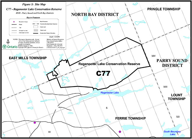
Enlarge Figure 3: Site map, C77 – Raganooter Lake Conservation Reserve
Figure 4: Site map, C78 – Big Deer Lake Conservation Reserve
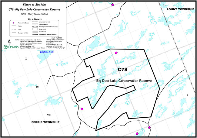
Enlarge Figure 4: Site map, C78 – Big Deer Lake Conservation Reserve
Figure 5: Site map, C81 – Ferrie Township Forest Conservation Reserve
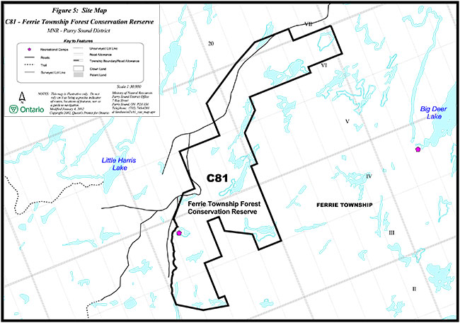
Enlarge Figure 5: Site map, C81 – Ferrie Township Forest Conservation Reserve