Scenic Lake Conservation Reserve Management Statement
This document provides policy direction for the protection, development and management of the Scenic Lake Conservation Reserve and its resources.
OMNR, Kenora District
May, 2001
Updated April 7, 2011
Next Examination Due December 31, 2020
Examination and adjustment history of management direction
Table of adjustment history of management direction
| Approval date | Examination or type of adjustment | Examination outcome | List of supporting documents |
|---|---|---|---|
| May 24, 2012 | Examination | Administrative Update |
|
Approval statement
We are pleased to approve this Statement of Conservation Interest for the Scenic Lake Conservation Reserve.
This Statement of Conservation Interest provides guidance for the management of the conservation reserve and the basis for the ongoing monitoring activities. More detailed direction at this time is not anticipated. Should significant facility development be considered or complex issues arise requiring additional studies, more defined management direction, or special protection measures, a more detailed Conservation Reserve Management Plan will be prepared with full public consultation.
The public was widely consulted during the original regulation process and further consultation is not required at this time.
The conservation reserve will be managed under the jurisdiction of the Kenora East Area Supervisor, Ministry of Natural Resources.
Signed,
Fred Hall
District Manager
Kenora District
Date: September 6, 2001
Signed,
Charlie Lauer
Regional Director
Northwest Region
Date: September 20, 2001
1.0 Background information
During the Lands For Life process, areas representative of Ontario’s diverse ecosystems and biological/geological features were identified and recommended for regulation as parks and protected areas under the Provincial Parks Act and the Public Lands Act (OMNR, 1999). The goal is to expand the percentage of Ontario’s protected areas to encompass twelve percent of the province’s land and water base. Scenic Lake Conservation Reserve is one of the representative areas selected for protection in site region/districts 4S-2 and was regulated on May 21, 2003. The area was selected as a candidate under Ontario’s Living Legacy due to the representative landform and vegetation types (primarily burns and mixed forests on organic deposits and weakly broken bedrock) existing in the area.
Scenic Lake Conservation Reserve is located approximately 53 kilometres north of the City of Kenora. This reserve incorporates Scenic Lake, all islands within the lake, Moose Lake, and a 200 metre buffer zone around the lake shores. The total area is approximately 2,180 hectares in size (OMNR, 2000a). Aboriginal interests in the area are primarily those of the Grassy Narrows First Nation.
The intent of this Statement of Conservation Interest is to identify the natural heritage values of Scenic Lake Conservation Reserve, the activities occurring in the area and, (through a set of management guidelines), outline the activities that will be permitted and prohibited.
For more information regarding the basis of this Statement, please refer to the “Conservation Reserve Policy and Procedure PL3.03.05”, specifically, pages 2 — 6 and 14 — 22 of the procedure (OMNR, 1997a).
Overview data describing Scenic Lake Conservation Reserve and location
- Name: Scenic Lake Conservation Reserve (C2365)
- Site Region/Site District: 4S-2
- OMNR Administrative Region/District/Area: Northwest/Kenora/English River
- Total Area (ha): 2,180 ha
- Regulation Date: Anticipated in 2001
- First Nations with Interest in Area: Grassy Narrows First Nation – Treaty #3
- OBM: 50015410055650
- Lat./Long.: 50º 14’ / 94º 14’
- Basemap: 502941, 502942, 503941, 503942
- FRI Stand Numbers (located partially and fully within Scenic Lake Conservation Reserve: 54, 351, 1148, 2049, 1852, 1453, 1652, 2249, 2453, 2948, 2957, 2859, 3162, 2865, 2869, 2265, 2061, 1661, 1062, 562, 767, 1969, 2070, 2469, 2472, 3377, 3577, 3080, 3487, 3884, 4878, 3970, 4376, 4767, 4962, 5069, 4363, 3964, 3562, 4560, 4757, 5154, 5746, 5245, 5243, 5742, 6041, 5534, 5536, 4931, 4430, 3736, 3341, 2738, 2340, 2643, 2042, 1437, 1038, 1027, 1226, 817, 619, 312, 124, 227, 232, 434, 1042, 541, 443, 145, 9254, 9561, 9755, 9945, 9146, 8043, 9151, 8759, 8453, 9714, 9820, 9613, 9416, 9822, 4050, 4151, 4047, 3162
- General Location Description: The site is located approximately 53 kilometres north of the City of Kenora, and 15 kilometres northwest of the Grassy Narrows First Nation.
- Access: The reserve is accessible by air and water, and marginally accessible by road.
1.1 Representation targets
This section provides a summary of the earth/life science values, cultural resources, and the recreational opportunities available or possible within Scenic Lake Conservation Reserve.
- Life Science Representation: The reserve contains representation of several forest types, including aspen, white birch, balsam fir, white and black spruce, and jack pine (North-South Environmental Inc., 2000b). (Refer to Appendix F). There is also an eagle nest on the largest island and areas of wetland vegetation. (See Appendix E).
- Earth Science Representation: The site is part of the Winnipeg River Geological Subprovince and contains weakly broken bedrock, granite deposits, and lacustrine plain (North-South Environmental Inc., 2000a). (Refer to section 2.1.2).
- Cultural Resource Representation: No significant values have been identified except for the four historical portages throughout the lake (section 2.1.6). (Refer to Appendix D for portage locations).
- Recreational Opportunities: Fishing opportunities exist for northern pike and smallmouth bass. There are also boating opportunities, as well as snowmobiling, and hunting opportunities for moose, deer, black bear, small game, and waterfowl.
1.2 Survey information
This section provides an overview of the inventories that were completed, their level of detail, and any further inventories that are necessary.
| Survey level | Reconnaissance | Detailed |
|---|---|---|
| Life Science | Checklist and summary report completed by North-South Environmental Inc. Survey conducted by helicopter during September, 2000. | Not required. |
| Earth Science | Checklist and summary report completed by North-South Environmental Inc. Survey conducted by helicopter during September, 2000. | Not required. |
| Cultural | Required. | Not required. |
| Recreational | Checklist and inventory report completed by OLL staff. Survey conducted by helicopter on August 29th, 2000. | Not required. |
| Other (Creel) | Creel survey. |
2.0 Values to be protected
This section provides a description of the key natural heritage values on the site, their condition relative to past resource use and management activities, as well as their sensitivity to future land use and management activities.
2.1 Values identified on the site
2.1.1 Life sciences
Mixed forests and representative vegetation types were expected to be found in the Scenic Lake Conservation Reserve (OMNR, 1999). The life science surveys identified the following life science values.
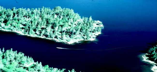
Dominant Forest Types: The forest surrounding Scenic Lake was found to include open and closed deciduous stands of aspen, and birch, and mixed stands of balsam fir, white and black spruce, aspen, and birch (North-South Environmental Inc., 2000b). There were a few areas where jack pine communities were found situated on the dry, rocky outcrops. A few bur oak saplings were sited on a small, rocky point to the west of the island located at 413250E and 5565000N.
Figure 1: Black Spruce stand and boat on Scenic Lake
There are no proposed cut blocks around the Scenic Lake Conservation Reserve but there has been previous logging around Aesthetic Road prior to its entrance into the reserve. Abitibi Consolidated has no future plans to harvest the trees around the Scenic Lake Conservation Reserve (Anderson, 2001).
Representative vegetation including bunchberry, lily of the valley, wild sarsaparilla, blue bead lily, twinflower, red raspberry, strawberry, and wild rose were found to cover the ground in the Scenic Lake Conservation Reserve (North-South Environmental Inc., 2000b).
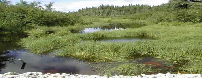
Wetlands were not very common within the site as they are only found in the small bays within Scenic Lake (North-South Environmental Inc., 2000b). One of the most interesting features was the wetland gradation just north of the tourist lodge.
Figure 2: Wetland vegetation in Scenic Lake Conservation Reserve
2.1.2 Earth sciences
Scenic Lake Conservation Reserve was selected as a candidate for protection under Ontario’s Living Legacy because of its representative landforms, weakly broken bedrock, and organic deposits (OMNR, 1999). The earth science survey identified the following earth science values.
Figure 3: Exposed bedrock in Scenic Lake Conservation Reserve
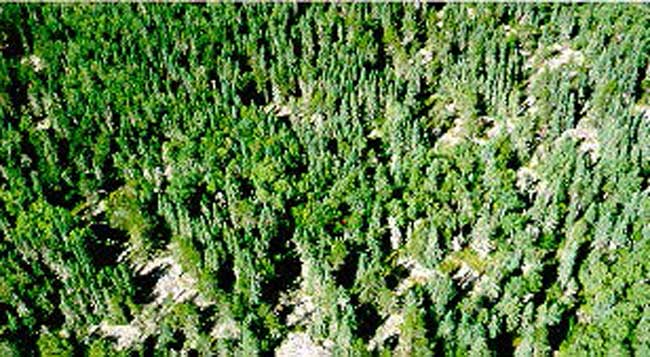
The Scenic Lake Conservation Reserve is represented by the Winnipeg River Geological Subprovince. Massive granite deposits, exposed bedrock and lacustrine plain dominated the majority of the topography within the reserve (North-South Environmental Inc., 2000a). Weakly to moderately broken rock knob flanked by thin, silty, sand till and silty clay glaciolacustrine deposits were also found during the earth science survey of the reserve (North-South Environmental, 2000c). One small section of varved clay and silt was also found at the extreme northern tip of the reserve (Zoltai, 1960). The varving is a colour variation in the clay that results from water becoming trapped on top and staining the first several layers (Dawe, 2001).
2.1.3 Tourism
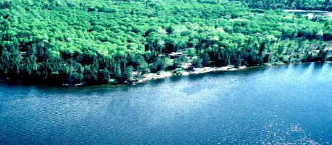
There is one tourist camp located within the Scenic Lake Conservation Reserve. It is located in the southeastern portion of Scenic Lake. The lodge is owned by William Krolyk (925710 Ontario Inc.), and caters mostly to anglers. It can accommodate up to six people at one time (Moorley, 2001). On the day of the recreation survey, several boats were seen on the lake. Most of the anglers within Scenic Lake are American tourists but local anglers fish the lake as well. (For location, see Appendix D).
Figure 4: 925710 Ontario Inc. outpost camp on Scenic Lake
2.1.4 Aboriginal values
Any specific aboriginal values or interests with Scenic Lake Conservation Reserve remain unidentified at this time.
2.1.5 Recreational fishing
Fishing opportunities exist in Scenic Lake for northern pike and smallmouth bass (OMNR, 1976). On the day of the recreational study, several fishing boats were seen within the lake indicating that fishing is probably an important recreational activity within the Scenic Lake Conservation Reserve.
2.1.6 Cultural/historical values
Several historical portages are present within the reserve and some of these portages may still be in use today by hunters, trappers, and fishermen (Zroback, 2000). For a map of the exact locations of these portages, see Appendix D.
- Portage #1: runs from the extreme southeast corner of Moose Lake to the closest tip on the northwest side of Big Fox Lake.
- Portage #2: runs north from the northern tip of Moose Lake to the extreme southern portion of Scenic Lake.
- Portage #3: runs north from the southern portion of Scenic Lake to the main part of Scenic Lake.
- Portage #4: runs from the northern end of Scenic Lake on the west shore between Scenic and Midway Lake.
There have been no identified cultural values within the Scenic Lake Conservation Reserve as of yet. Future research regarding possible cultural or archaeological sites is recommended.
2.1.7 Recreational hunting
Hunting opportunities exist in the reserve for black bear, deer, moose, small game, and waterfowl. Scenic Lake Conservation Reserve is part of Wildlife Management Unit #6. There is one Bear Management Area (KE-06-027) within the reserve and it is licensed to Stewart Lake Airways.
2.1.8 Mining
The mineral potential in the Scenic Lake Conservation Reserve is undetermined at this time. Mining is prohibited within the reserve, however, careful mineral exploration may occur in specific new conservation reserves proposed through Ontario’s Living Legacy Land Use Strategy in areas deemed to have a provincially significant mineral potential. If an area is to be developed for a mine, it would be removed from the reserve and appropriate replacement lands would be placed in regulation (OMNR, 2000b).
2.1.9 Aggregates
There is no aggregate exploration or development in the Scenic Lake Conservation Reserve (Moorley, 2001).
2.1.10 Forest harvesting
Forest harvest is scheduled for blocks south and east of the conservation reserve during the 2012-2022 Whiskey Jack Forest Management Plan. Aesthetic Road will be used to access the area.
2.1.11 Trapping
Scenic Lake Conservation Reserve is part of two traplines registered to members of the Grassy Narrows First Nation. Trapping will be permitted to continue, however, new operations will be subject to the protected areas compatibility test (OMNR 2010).
2.1.12 Wildlife
Moose, deer, black bear, and timber wolf reside in and around the Scenic Lake Conservation Reserve. There is also an eagle nest located on the largest island within the reserve and several osprey nests and heron rookeries in the vicinity (See Appendix E).
2.1.13 Commercial fishing
The reserve is part of three commercial baitfishing blocks. These operations will continue. New baitfishing operations may be permitted (OMNR 2006).
2.2 Values to be protected
The intent of this Statement is to protect identified values by establishing management guidelines for existing and potential uses in this area given the level of past disturbance and the nature of the existing features.
2.2.1 Forest values
The forest values within the reserve boundaries are to be protected from any unnatural alteration (OMNR, 1999; 1997a). Successional changes associated with each forest type occurring in the area (depending on each stand’s stage of maturity, specific vegetative species composition, and soil type) are anticipated to take place as outlined in the following statements. For the purpose of this document, the successional time frame is depicted as 100 years.
Black spruce, jack pine, and poplar dominate the reserve. Smaller stands of red pine, birch, and white spruce are also found within the reserve. In areas where jack pine dominates, succession will move towards a black spruce dominated stand (OMNR, 1997b). Due to the shallow soil conditions within the reserve, the succession towards black spruce will be much more open and savannah like. The conifer-dominated stands within the reserve are on average 81 years old but some are as much as 100 years old. There is one pure black spruce stand that is 155 years old.
The hardwood-dominated stands are an average of 78 years old but some stands are as old as 100 years. At this age, canopy cover starts to decline and the hardwood component is slowly replaced by coniferous species, particularly, white and black spruce, and balsam fir (OMNR, 1997b). Residual poplar has been known to persist for as long as 200 years on moist sites, but since the majority of the Scenic Lake topography is bare bedrock, this is unlikely to happen.
The lower forest level and understory within the reserve consists of mountain maple, beaked hazel, balsam fir, paper birch, strawberry, raspberry, and blueberry plants. The vegetative communities are in very good condition and generally only subjected to natural disturbance factors such as fire. In the hardwood-dominated areas, the natural succession will be towards a decrease in the abundance of understory and herb cover (OMNR, 1997b). The diversity of the vegetative cover is limited since the terrestrial portion of the reserve consists only of a 200 metre buffer zone around Scenic Lake (North-South Environmental Inc., 2000b).
2.2.2 Recreational values
The area is very popular for recreational boating and fishing. Other activities occurring within the reserve include ice-fishing, snowmobiling, and hunting.
2.2.3 Tourism values
The reserve is a popular smallmouth bass and northern pike fishing area. One tourist camp is present on Scenic Lake and there are four commercial boat caches within the reserve. Scenic Lake is a popular tourist destination for American anglers.
3.0 Management guidelines
The following topics briefly indicate the existing situation followed by the management guidelines to be implemented or continued.
3.1 Land tenure
The Scenic Lake Conservation Reserve consists entirely of Crown land. No disposition by sale, Crown Lease, or Land Use Permit will be permitted within the reserve.
3.2 Existing and proposed development
There is one commercial tourist camp on Scenic Lake and four commercial boat caches. No further development (such as campsites and trails) will be permitted in the area that would result in disturbance of the forest, including its understory.
The existing tourist camp in Scenic Lake is owned by William Krolyk (925710 Ontario Inc.), and can accommodate up to six people. The camp caters mostly to anglers.
3.3 Recreational activities
Both sport-fishing and hunting will continue to be allowed within the reserve. Snowmobiling will generally be permitted to continue provided that the activity does not adversely affect the values being protected. Existing snowmobile trails will be permitted to continue unless there are significant demonstrated conflicts (OMNR, 2000b).
3.4 Commercial activities
There are two registered traplines within the area and trapping will continue to be permitted within the reserve. Presently, the site is also part of one Bear Management Area and no changes will be required at this time. No further commercial activities will be permitted within the reserve, including hydro-electric development, mining, logging, road construction, or the development of utility corridors.
The area has been permanently removed from the operable Whiskey Jack Forest Land Base and withdrawn from all mining exploration and extraction activities by the Ministry of Northern Development, Mines and Forestry (MNDMF) at the MNR’s request.
3.5 Aboriginal interests
Scenic Lake Conservation Reserve is located within a primary interest area of the Grassy Narrows First Nation. Any specific aboriginal values associated with the reserve are unknown at this time, although they may be identified during First Nation consultation. However, nothing in this Statement of Conservation Interest will affect existing or future aboriginal or treaty rights. There are three commercial boat caches and two traplines registered to members of the Grassy Narrows First Nation. It can be surmised then that trapping within the Scenic Lake Conservation Reserve will be the main area of interest for the Grassy Narrows First Nation.
3.6 Natural resources stewardship
3.6.1 Vegetation management
The Forest Fire Management Strategy for Ontario (OMNR 2004) places Scenic Lake Conservation Reserve in the boreal zone providing the same level of protection from fire as the surrounding forest. Should large scale disturbance (forest fires, blow downs) not take place, the area will naturally evolve through successional processes, likely progressing as outlined in section 2.2.1.
Fuelwood permits will not be issued within the area encompassed by the Scenic Lake Conservation Reserve. However, usage of the areas wood resources for shorelunches and campfires will be permitted provided that there will be no resulting damage or alteration of the forest and its understory.
3.6.2 Fish and wildlife management
No management action is required other than the implementation of existing Wildlife Management Unit #6 regulations, Division 31 sport-fishing regulations, and management activities.
3.6.3 Landforms
The landforms represented within Scenic Lake Conservation Reserve will not be altered through any landform modification activities, including filling and extraction of aggregates, peat, soils, and similar materials (OMNR, 1997a).
3.7 Cultural resources stewardship
Based on existing information, there are no requirements at this time.
3.8 Client services
Information regarding this conservation reserve will be made available so as to ensure that all resource users (particularly forestry and mining companies) are aware of its location, recognized values, and permitted uses. Potential users include tourists, local and international fishermen and hunters, recreationalists (i.e. canoeists, hikers, snowmobilers), and the general public, all of whom may utilize the area’s resources for camping, shorelunches, firewood, and personal use.
3.9 Research
Since little is known about possible cultural values within the Scenic Lake Conservation Reserve, non-destructive research relating to the possible cultural, historical, and archaeological values within the reserve would be beneficial.
Surveys of Scenic Lake have been conducted in the past, however, since Scenic Lake appears to be such a popular sport-fishing lake, another more up-to-date creel survey would be very beneficial.
3.10 Marketing
There are no marketing requirements at this time.
4.0 Implementation
These management guidelines will be implemented immediately by Kenora District. Any MNR Resource Management Plans or Land Use Plans which include this area will be amended accordingly. Any affected clients will be immediately informed of amendments to this management direction. Administrative responsibility for the conservation reserve rests with the Planning and Information Management Supervisor. Implementation will primarily involve monitoring activities to ensure adherence to the management guidelines.
5.0 Review and revisions
5.1 Review and revisions
Methods of reviewing management direction will be consistent with the Protected Areas Planning Manual (OMNR 2009) and its associated guidelines. In accordance with the Provincial Parks and Conservation Reserves Act, 2006, MNR will annually examine management direction documents that have been in place for ten years or more. The next scheduled examination for Solitary Lake Conservation Reserve will be in 2020.
5.2 Present and future consultation
5.2.1 Results of past consultation
Contact regarding the regulation of Scenic Lake Conservation Reserve was made with timber companies, local communities, and the general public in August, 2000. Consultation efforts involved the direct mailing of a District information package to local interest groups (such as the Local Citizens Committee), as well as to all those with patent land, boat caches, bear management areas, baitfishing areas, traplines and Sustainable Forest Licenses within and/or adjacent to the reserve’s proposed boundaries. In addition, an interview was held on CJRL radio in Kenora and newspaper advertisements were issued in the Kenora Enterprise and the Kenora Daily Miner and News in mid-August. As a result of public consultation, the only feedback regarding the Scenic Lake Conservation Reserve involved general inquiries regarding the permitted and prohibited activities within the reserve.
First Nation consultation associated with Scenic Lake Conservation Reserve occurred.
5.2.2 Present and future consultation
Other than the completion of the First Nation consultation, more widespread consultation for this site is not deemed necessary at this time due to the extensive public consultation process that took place in August, 2000. (Refer to section 5.2.1).
Author
This Statement of Conservation Interest was prepared by Catherine Reaburn, OLL Intern, Kenora District.
6.0 References
Anderson, Dave. 2001. Area Forester. Personal Correspondence. OMNR, Kenora District.
Dawe, Mike. 2001. Senior Forest Specialist. Personal Correspondence. OMNR, Kenora District.
Moorley, Robert. 2001. Resource Management Technician. Personal Correspondence. OMNR, Kenora District.
North-South Environmental Inc. 2000a. Earth and Life Sciences Reconnaissance Survey. 14, Provincial Parks and Conservation Reserves in the Western Part of Northwestern Ontario: Summary Report to the Earth and Life Science Checksheets.
North-South Environmental Inc. 2000b. Life Science Checksheet.
North-South Environmental Inc. 2000c. Earth Science Inventory Checklist.
[OMNR] Ontario Ministry of Natural Resources, 1976. Scenic Lake Survey File, Kenora District.
[OMNR] Ontario Ministry of Natural Resources. 1997a. Conservation Reserves Policy and Procedure. PL 3.03.05
[OMNR] Ontario Ministry of Natural Resources, 1997b. Silvicultural Guide to Managing for Black Spruce, Jack Pine and Aspen on Boreal Forest Ecosites in Ontario. Book II: Ecological and Management Interpretation for Northwest Ecosites. Version 1.1 September, 1997.
[OMNR] Ontario Ministry of Natural Resources. 1999. Ontario’s Living Legacy Land Use Strategy.
[OMNR] Ontario Ministry of Natural Resources. 2000a. Ontario’s Living Legacy Factsheet – Scenic Lake Conservation Reserve.
[OMNR] Ontario Ministry of Natural Resources. 2000b. Activity/Use Policies in Conservation Reserves.
[OMNR] Ontario Ministry of Natural Resources. 2004. Forest Fire Management Strategy for Ontario. Queen’s Printer for Ontario. Toronto. 64 pp.
[OMNR] Ontario Ministry of Natural Resources. 2006. Crown Land Use Policy Atlas Policy Report: C2365 – Scenic Lake. Queen’s Printer for Ontario
[OMNR] Ontario Ministry of Natural Resources. 2009. Ontario Protected Areas Planning Manual. Peterborough. Queen’s Printer for Ontario. 50 pp.
[OMNR] Ontario Ministry of Natural Resources. 2010. Protected Areas Compatibility Test Draft.
Provincial Parks and Conservation Reserves Act. 2006. Toronto. 44 pp. [online].
Zoltai, S.C. 1960. Ontario Department of Lands and Forests. Surficial Geology — Map of Kenora – Rainy River.
Zroback, Fred. 2000. Resource Management Technician. Personal Correspondence. OMNR, Kenora District.
Appendix A: Map of OLL sites within the northwest region
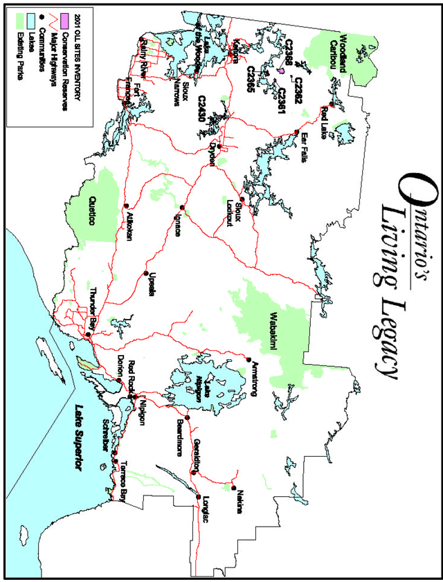
Enlarge map of OLL sites within the northwest region (PDF)
Appendix B: Map of Scenic Lake Conservation Reserve boundary
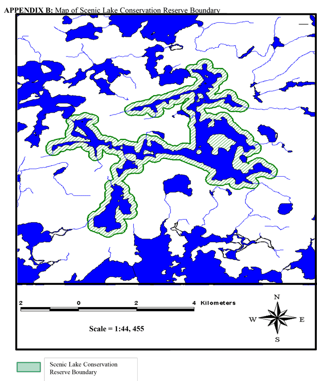
Enlarge map of Scenic Lake Conservation Reserve boundary (PDF)
Appendix C: Recreation inventory checklist – Scenic Lake Conservation Reserve
- Name: Scenic Lake Conservation Reserve C2365
- Map name: 52L/1 & 52L/8 NTS
- Number: n/a
- UTM reference: 5561100N – 5568450N, 408150E – 416000E
- OBM number: 41556 & 40556
- Latitude: 50 10’ 35”
50 10’ 05” - Longitude: 94 10’ 35”
94 10’ 00” - Area (ha): 1,887
- Ownership: MNR
- MNR Region: Northwest
- MNR district: Kenora
- Park zone: [no information provided]
- County: [no information provided]
- Township: [no information provided]
- Recreation features:
- A01— Sport Fish
- A02— Aquatic Habitat/Wildlife Diversity
- E08— Wetland Vegetation
- B25— Small Island
- J06— Bedrock, exposed
- E05— Mixed Coniferous/Deciduous
- Recreation features recreation activities:
- F00— Fishing — General
- B01— Boating
- F05— Ice-fishing
- D10— Snowmobiling
- H01— Game, large mammal
| Recreation | Features | Rating: Very High, High, Moderate, Low, N/A |
|---|---|---|
| Most scarce feature | 3 | |
| Feature scarcity | High | |
| Most Unique Feature | 3 | |
| Activity Attraction Capability | Moderate | |
| Scenic Attractiveness | Moderate | |
| Geographic Significance: | Very High | |
| Feature Significance | Very High | |
| Most Sensitive Feature to Recreation Use | 1 | |
| Feature Sensitivity To Recreation Use | High | |
| Most Sensitive Feature To Resource | 2 | |
| Feature Sensitivity To Resource Development: | Moderate | |
| Cultural Historic and Archaeological Features: | N/A |
- Comments: Mostly American tourists in the area. Appears to have a lot of fishing pressure.
- Date Compiled: September 27/00
- Compilers: Sheila Thomson & Amanda Watson
- Source: Recreation Resource Inventory Standards and Procedures Draft Report, Government of British Columbia, Ministry of Forests Range, Recreation and Forests Practices Branch, March 1995.
Appendix E: Map of wetland vegetation, spawning areas and stick nests
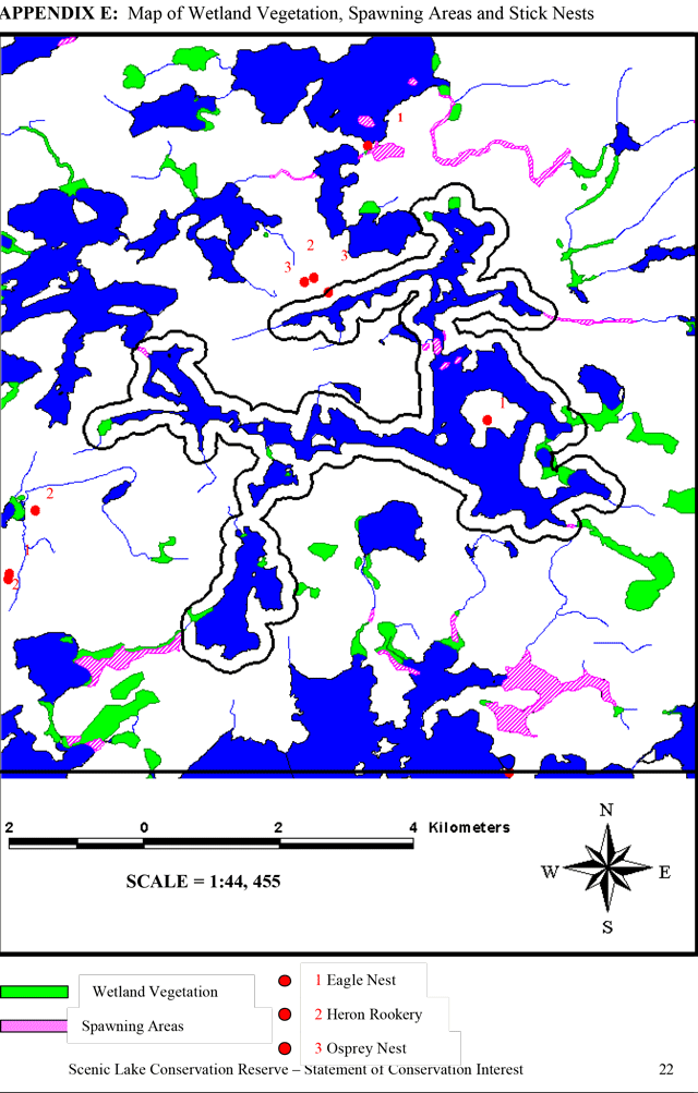
Enlarge map of wetland vegetation, spawning areas and stick nests (PDF)
Appendix F: Natural Heritage Area – life science checksheet — Scenic Lake
- Name: Scenic Lake Conservation Reserve C2365
- Map Name: Lount Lake
- Map Number: 52 L/01
- UTM Ref.: 412750, 5565000
- County: Unorganized Area
- Lat.: 50 14’
- Long.: 94 14’
- NAD: 83
- Min. Alt.: 320
- Max. Alt.: 340
- Locality: Unorganized Area
- Township: Unorganized Area
- Area: [no information provided]
- Ownership: Crown Land
- MNR Region: Northwest
- Ecoregion and Ecodistrict: 4S2
- Landform Unit(s): See attached table
- MNR District: Kenora
- Aerial Photographs: Year – Roll – Flight Line – Numbers
Map of Scenic Lake Natural Heritage Area
Physical and biological features
Representation
Dominant forest types include open and closed deciduous stands, with aspen and birch, and mixed stands with fir, white and black spruce, aspen and birch. Jack pine communities are characteristic of dry rocky sites. The deciduous and mixed types predominate because the reserve consists mostly of a buffer around lakes where the slopes are covered by this vegetation type. Wetlands are few, occurring only at creek mouths and in small lake bays. They are represented by marshes and meadows with Scirpus validus, Scirpus cyperinus, Typha latifolia, Dulichium arundinaceum and Calamagrostis canadensis. Associated with them, along the forest edge are speckled alder thicket swamps. Open rock outcrops with juniper and scattered Jack pine are uncommon.
Condition:
The vegetative communities are in very good condition, being subjected principally to natural disturbance factors, mostly fire. An access road at the southernmost end of the reserve may introduce some local human disturbance. The lodge site at the eastern end of the reserve appears to cause only local impact.
Diversity:
Due to the reserve’s being a boundary feature around the lake, the level of diversity of vegetation cover is limited. While the forests represent a range of types (albeit mostly associated with slope), the extent and variation of wetlands is limited. Only in one area, just north of the lodge, a gradation from open fen to black spruce treed bog and swamp was observed.
Ecological considerations:
The narrow character of the reserve and lack of any interior forest potential are reasons for the reserve’s vulnerability to disturbance (especially logging) from just the outside of its boundary.
Special features
The reserve provides representation of common vegetation types of the area. The two potentially interesting features appear to be the wetland gradation just north of the lodge (see “Diversity” above) and a sighting of a few bur oak saplings on a small rocky point to the west of the island (413250E, 5565000N).
Major information sources
- Field work (September 2000)
- Significance Level (Provincial/Regional/Local) and Brief Summary of Major Representative Values: Regional significance owing to the occurrence of bur oak.
- Date Compiled: November 2000
- Compiler: Christopher Zoladeski, North-South Environmental Inc.
Scenic Lake Conservation Reserve
Plot sampling methods follow those outlined in:
North-South Environmental Inc. 2000. Earth and Life Science Reconnaissance Survey. 14 Provincial Parks and Conservation Reserves in the Western Part of Northwestern Ontario: Summary Report to the Earth and Life Science Checksheets. 20pp.
Plot 1: 412848E 5565139N, Slope 10°, South aspect
Description: Open-canopied deciduous forest. Heavy tall shrub layer. Typical of lakeside slopes in the area.
Composition:
T:
- Populus tremuloides 3
- Picea glauca
- Populus tremuloides 2
- Picea mariana
- Betula papyrifera 2
TS:
- Corylus cornuta 4
- Acer spicatum 3
- Abies balsamea 1
LS:
- Abies balsamea 2
H:
- Cornus canadensis
- Maianthemum canadense +
- Lycopodium complanatum +
- Lycopodium obscurum +
- Linnaea borealis +
- Oryzopsis asperifolia +
- Aralia nudicaulis +
- Clintonia borealis +
- Aster macrophyllus +
M-L:
- Lycopodium clavatum +
- Brachythecium spp.
Other notes: Garter snake on rocks just outside of reserve (N of plot 1).
Plot 2: 413016E 5564970N
Description: Birch-spruce mixedwood, typical of shoreline slopes.
Composition:
T:
- Betula papyrifera 3
- Picea mariana 2
TS:
- Abies balsamea 2
- Betula papyrifera 2
LS:
- Juniperus communis 1
- Rubus idaeus +
- Alnus rugosa +
- Rosa acicularis +
H:
- Vaccinium myrtilloides +
- Linnaea borealis
- Chimaphila umbellata +
- Fragaria virginiana
- Maianthemum canadense +
- Pyrola asarifolia +
- Oryzopsis asperifolia +
M-L:
- Solidago multiradiata +
- Brachythecium spp.
Other vegetation communities: upslope, this forest type changes to birch deciduous, with some aspen, which is also common in the area.
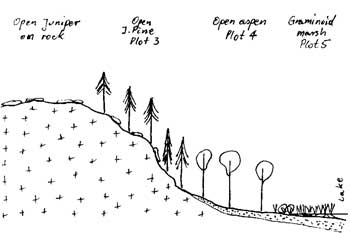
Plot 3: 411088E 5564573N
Composition:
T:
- Pinus Banksiana 2
- Picea mariana 1
TS:
- Betula papyrifera 1
- Populus tremuloides 1
- Pinus Banksiana +
LS:
- Juniperus communis 4
- Salix sp.+
- Prunus pumila+
- Vaccinium myrtilloides 3
- Prunus pensylvanica+
- Arctostaphylos uva-ursi+
- Amelanchiersp. +
- Diervilla Lonicera+
- Rubus idaeus +
H:
- Carex sp. +
- Maianthemum canadense +
M-L:
- Cladina rangiferina 1
- Cladina mitis 1
- Dicranum spp.
Description: Open Jack pine stand around the top of large rock knob, extensive patches of juniper. Composition:
Other notes: Moose feces.
Plot 4: 411145E 5564495N
Description: Very open aspen stand, trees 25 m tall, tops and upper parts of trunks of many snapped off, snags and logs abundant. Heavy tall shrub layer.
Composition:
T:
- Populus tremuloides 2
- Picea mariana
TS:
- Acer spicatum 3
- Corylus cornuta 3
LS:
- Rubus pubescens 2
- Diervilla Lonicera
- Abies balsamea +
- Amelanchier sp. +
H:
- Cornus canadensis 2
- Aster macrophyllus
- Fragaria virginiana
- Aster ciliolatus +
- Linnaea borealis +
- Lathyrus ochroleucus +
- Clintonia borealis +
- Oryzopsis asperifolia +
- Galium triflorum +
M-L:
- Brachythecium spp. +
Plot 5: 411133E 5564430N
Description: Located in a small bay, this is a shallow (20-30 cm deep), graminoid marsh of Calamagrostis and Scirpus, with some Typha. Typical of wetlands in the area. Composition:
H: Calamagrostis canadensis 3, Scirpus cyperinus 3, Typha latifolia 2, Carex sp.
Other vegetation communities: In deeper water are patches of the Dulichium arundinaceum community.
Other notes: In the past, aspen grew on the shoreline but now water levels have risen and the trees died (several big snags still standing along the shore).
Plot 6: 414353E 5565270N
Description: Wet Calamagrostis dominated meadow. Ground a bit spongy, but firming up. Main herb layer 1.5 m tall. A few water pools. Small meadow, ca. ¼ ha, amidst forest. Composition:
H: Calamagrostis canadensis 5, Scirpus cyperinus +, Viola sp. +
Plot 7: 414310E 5565250N
Description: Tall (3-4 m) shrub swamp of alder on a wet site. This community surrounds the Calamagrostis meadow. Alder swamp is rare in the reserve.
Composition:
TS:
- Alnus rugosa 5
LS:
- Rubus idaeus 3
H:
- Calamagrostis canadensis 5
- Viola sp. +
- Dryopteris spinulosa 2
- Dryopteris disjuncta +
- Carex sp. +
M-L:
- Sphagnum spp. 2
- Brachythecium spp. 2
Other vegetation communities: The island is covered mostly by aspen stands, there is also a spruce stand.