Scotty Lake Conservation Reserve Management Statement
This document provides policy direction for the protection, development and management of the Scotty Lake Conservation Reserve and its resources.
OMNR, Kenora District
July, 2001
Updated April 7, 2011
Next Examination Due December 31, 2020
Examination and adjustment history of management direction
Table of adjustment history of management direction
| Approval date | Examination or type of adjustment | Examination outcome | List of supporting documents |
|---|---|---|---|
| May 24, 2011 | Examination | Administrative Update |
|
Approval statement
We are pleased to approve this Statement of Conservation Interest for Scotty Lake Conservation Reserve.
This Statement of Conservation Interest provides guidance for the management of the Scotty Lake Conservation Reserve including the new Ontario’s Living Legacy (OLL) site C2361, and the basis for the ongoing monitoring activities. This document replaces the previous Statement of Conservation Interest that was approved for the original Scotty Lake Conservation Reserve in 1998. More detailed direction at this time is not anticipated. Should significant facility development be considered or complex issues arise requiring additional studies, more defined management direction, or special protection measures, a more detailed Conservation Reserve Management Plan will be prepared with full public consultation.
The public was widely consulted during the original regulation process for the Scotty Lake Conservation Reserve as well as OLL site C2361, and further public consultation is not required at this time.
The conservation reserve will be managed under the jurisdiction of the Kenora East Area Supervisor, Kenora District, Ministry of Natural Resources.
Signed by
Fred S. Hall
District Manager
Kenora District
September 6, 2001
Charlie Lauer
Regional Director
Northwest Region
September 9, 2001
1.0 Background information
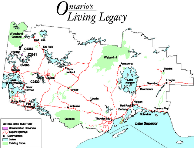
During the Lands For Life process, areas representative of Ontario’s diverse ecosystems and biological/geological features were identified and recommended for regulation as parks and protected areas under the Provincial Parks Act and the Public Lands Act (OMNR, 1999).
The goal is to expand the percentage of Ontario’s protected areas to encompass twelve percent of the province’s land and water base. Scotty Lake Conservation Reserve Addition is one of the representative areas selected for protection in site region/district 4S-2 and was regulated on May 21, 2003.
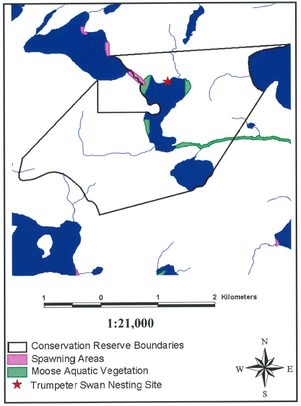
The original Scotty Lake Conservation Reserve (encompassing 51 hectares) had been identified as an area containing old growth White Pine on moderately broken ground moraine under the Keep It Wild initiative, and was brought under regulation January 7, 1995. Resulting from Ontario’s Living Legacy (OLL) natural heritage program, an additional 781 hectares adjacent to the previously existing conservation reserve was selected for protection due to the representative landform and vegetation types (primarily mixed and sparse forests on weakly broken ground moraine and burn) existing within the area. The Scotty Lake Conservation Reserve Addition (C2361) is the first expansion to a previously established conservation reserve in the Province of Ontario.
Scotty Lake Conservation Reserve (and OLL site C2361) is located approximately 69 kilometres north of the City of Kenora (OMNR, 2000). (Refer to Appendix A.) The reserve addition incorporates the area of land surrounding the existing conservation reserve boundary and includes two unnamed headwater lakes located southeast of Little Mountain Lake (Appendix B). Aboriginal interests in the area are primarily those of Grassy Narrows First Nation.
The intent of this Statement of Conservation Interest is to identify the natural heritage values of the Scotty Lake Conservation Reserve (including addition), the activities occurring within the area and (through a set of management guidelines) outline the activities which will be permitted and prohibited.
For further information regarding the basis of this Statement, please refer to the “Conservation Reserve Policy and Procedure PL3.03.05”, specifically, pages 2-6 and 14-22 of the procedure (OMNR, 1997a).
Overview data describing Scotty Lake Conservation Reserve and location
- Site region/Site district: 4S-2
- OMNRF Administrative Region/District/Area: Northwest/Kenora/English River
- Total area (ha): 832 ha
- Regulation date: 1995; anticipated in 2002
- First Nations: Grassy Narrows First Nation (Treaty #3)
- OBM: 2015410055700
- Lat./Long.: 50 20’/94 08’
- Basemap: 502941
- FRI Stands: 168, 456, 459, 465, 861, 1062, 1172, 1369, 1663, 2577, 7451, 7455, 7658, 8152, 8157, 8364, 8459, 8550, 8558, 8568, 8655, 8659, 8757, 8843, 8860, 8951, 8979, 9149, 9156, 9160, 9166, 9258, 9354, 9456, 9574, 9764, 9770, 9748, 9855, 9972.
- General location description: Located approximately 69 kilometres north of the City of Kenora (Appendix A).
- Access: The two unnamed headwater lakes within the reserve are accessible by float plane only. The northeastern extremity, which borders along a sand beach on Scotty Lake, is accessible via boat from Dumpy Lake. In addition, the forested area in the southwest portion of the conservation reserve is made accessible along the Scotty Lake Road.
1.1 Representation targets
This section provides a summary of the earth/life science values, cultural resources represented, and recreational opportunities available or possible within the Scotty Lake Conservation Reserve (including addition).
Summary of earth/life science and cultural representation as well as recreational opportunities
- Life science representation: Five critical landform-vegetation types are represented within Scotty Lake Conservation Reserve. The conservation reserve contains old growth White Pine (Pinus strobus) forest, as well as mixedwoods comprised of Jack Pine (Pinus banksiana), White Birch (Betula papyrifera), Spruce (Picea spp.), Trembling Aspen (Populus tremuloides), Red Pine (Pinus resinosa) and White Pine (North-South Environmental Inc., 2000c; Stevenson, 1998). Additional forest types include: extensive Aspen stands, Jack Pine on thin soils over bedrock, and (uncommonly) Black Spruce dominated types. Several wetland communities are also represented within the reserve, providing ideal moose aquatic vegetation forage sites. (Refer to section 2.1.1 and Appendix C.)
- Earth science representation: The site is represented by the Winnipeg River Subprovince of the Superior Province, which is dominated by massive igneous rocks (North-South Environmental Inc., 2000a). Extensive outcrops of granite and ranodiorite composition are represented within the reserve. (Refer to section 2.1.2.) A Lake Agassiz erosional channel located between Dumpy and Scotty Lakes may be of regional significance
- Cultural resource representation: Unidentified at this time.
- Recreational opportunities: Hunting (for Black Bear, Moose and White-tailed deer) and trapping opportunities exist within the conservation reserve. Additional activities potentially occurring within accessible areas of the reserve include Crown land camping, hiking, and scenic/wildlife viewing.(Refer to section 2.2.2.)
1.2 Survey information
This section provides an overview of the inventories completed their level of detail and any further inventories that are needed.
Table of inventories completed
| Survey level | Reconnaissance | Detailed |
|---|---|---|
| Life Science | Checklist and summary report, 2000.Survey conducted via helicopter. | Not required. |
| Earth Science | Checklist and summary report, 2000.Survey conducted via helicopter. | Not required. |
| Cultural | Suggested. | Not required. |
| Recreational | Recreational assessment, 2001. | Not required. |
| Other | Not required. | Not required. |
2.0 Values to be protected
This section provides a description of the key natural heritage values on the site, their condition relative to past resource use and management activities, as well as their sensitivity to future land use and management activities.
2.1 Values identified on the site
2.1.1 Life sciences
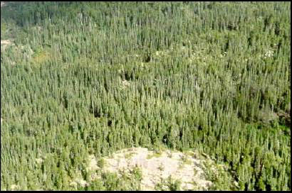
The previously established Scotty Lake Conservation Reserve contains an old growth White Pine community at the northern fringe of its range (Stevenson, 1998). The OLL site C2361 has been identified as an area containing representative vegetation types, comprising sparse and mixed coniferous/deciduous forest stands (OMNR, 1999). (Refer to Figure 1.) Life Science Inventories conducted in the area have confirmed the existence of mixed stands of Jack Pine, White Birch, Spruce, Aspen and scattered Red/White Pine (North-South Environmental Inc., 2000c). Also occurring within the reserve addition are extensive stands of Trembling Aspen, as well as Jack Pine on shallow soils over bedrock. Uncommonly found along either the upland or lowland areas of the reserve are Black Spruce dominated stands.
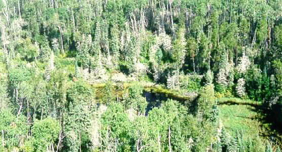
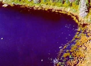
A diverse representation of wetlands also occurs within the conservation reserve addition boundaries (North-South Environmental Inc., 2000c). (Refer to Figure 2 Wetland vegetative cover types include: Fragrant White Water Lily (Nymphaea odorata) marshes; shallow water marshes of Creeping Spike-Rush (Eleocharis palustris); marshmeadows of Hairy-Fruited Sedge (Carex lasiocarpa) along lake shorelines; and, wetland sequences common to floodplains (i.e. from graminoid marsh to graminoid meadow to Alder (Alnus spp.) thicket swamp).
Figure 1. Mixed forest stands are common throughout the Scotty Lake Conservation Reserve
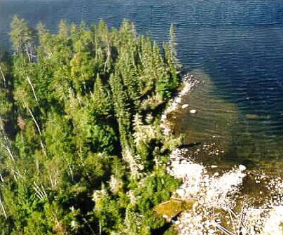
Figure 2. The Scotty Lake Conservation Reserve contains a diverse representation of wetland ecosystems
2.1.2 Earth sciences
The conservation reserve’s bedrock geology is represented by the Winnipeg River Subprovince of the Canadian Shield’s Superior Province (North-South Environmental Inc., 2000a). (Refer to Appendix D.) Massive igneous rocks predominate the Winnipeg River Subprovince, with granites and granodiorites (specifically) dominating within the Scotty Lake Conservation Reserve and forming extensive outcrops.
The landforms found within the Scotty Lake Conservation Reserve are a result of late glacial and immediate post-glacial processes and environments, occurring between approximately 11,200 and 10,000 years ago (North-South Environmental Inc., 2000a). Approximately 11,200 years ago, the Laurentide Ice Sheet advanced up the Rainy River Valley, and then retreated to the northeast, west, and northwest (Barnett, 1992; North-South Environmental Inc., 2000a). The result was the formation of the Eagle-Finlayson Moraine at the contact between the ice margin and Glacial Lake Agassiz. The Scotty Lake Conservation Reserve lies to the northwest of this significant moraine.
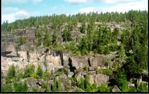
Through Earth Science Inventories, the following representative landforms were confirmed within the protected area: weakly broken bedrock rock knobs with glaciofluvial terraces; weakly to moderately broken rock knobs with deep glaciolacustrine silty clay; and, moderately broken rock knobs with silty sand till (ground moraine) flanks (North-South Environmental Inc., 2000b). Noted significant landform features include: two large cliffs with talus landform features located at 419652E/5577198N and (more significantly) 419910E/5577786N (Figure 3); a nearby glacial Lake Agassiz drainage channel located between Dumpy and Scotty Lakes; and a boulder lag slope under Red Pine forest.
Figure 3. Two significant cliffs are located north of the largest, unnamed, headwater lake within the reserve
2.1.3 Cultural/historical significance
No values of cultural/historical significance within the Scotty Lake Conservation Reserve have been identified.
2.1.4 Aboriginal values
Any specific aboriginal values within the conservation reserve remain unidentified at this time. (Please refer to section 3.5.)
2.1.5 Tourism
There are no tourist lodges/outposts located within or adjacent to the Scotty Lake Conservation Reserve. However, guests residing at Ashambie Outpost Limited and Maynard Lake Lodge and Outpost (on Maynard Lake), as well as Ball Lake Lodge (on Ball Lake) may access Scotty Lake through lake/creek systems. Therefore, the appealing sand beach along the conservation reserve’s northeast border may be utilized for shorelunches and resident Crown land camping.
In addition, accessible areas of the conservation reserve (i.e. along the northeast and southwest boundaries) may be valuable to the tourist industry by supporting hunting activities.
2.1.6 Recreational fishing
Due to inaccessibility of water bodies located within the Scotty Lake Conservation Reserve, recreational fishing is not likely practiced within the area.
2.1.7 Recreational hunting
The Scotty Lake Conservation Reserve forms parts of three Bear Management Areas licensed to camp operators (one Grassy Narrows First Nation operator). (Refer to Appendix E.) In addition, the potential for hunting other animal species (such as Moose, White-tailed Deer, and Ruffed/Spruce Grouse) exists in accessible areas of the conservation reserve, particularly along the Scotty Lake Road.
2.1.8 Mining
Mineral exploration and extraction activities are prohibited within the original Scotty Lake Conservation Reserve, however, careful mineral exploration may occur in the OLL site C2361 should the area be found to hold provincially significant mineral potential. If a portion of the conservation reserve addition is to be developed for a mine, it would be removed from the conservation reserve, and appropriate replacement lands would be placed in regulation.
2.1.9 Aggregate
None developed on site.
2.1.10 Forest Harvest
Timber within the previously established Scotty Lake Conservation Reserve is of high value and limited volume, and is to be protected (including the old growth component) from any unnatural disturbance (Stevenson, 1998).
Timber of commercial value, easy access, and significant volume exists within the OLL site C2361 (Anderson, 2001). Two harvest blocks (99.661 and 99.662) represented within the conservation reserve addition boundaries were approved in the 1999 – 2004 term of the Whiskey Jack Forest Management Plan. MNR has begun an amendment process to remove the blocks within the conservation reserve addition boundaries from the FMP. The area is currently under interim protection, ensuring that no approvals will be granted for harvest in these blocks.
2.1.11 Trapping
The Scotty Lake Conservation Reserve forms part of two registered trap lines licensed to Grassy Narrows First Nation trappers (Appendix F).
2.1.12 Wildlife
Evidence of Black Bear and Timber Wolves were noted along the Scotty Lake Road during site field visits on August 28, 2000. Also, Moose likely inhabit the protected area due to the abundance of aquatic vegetation available within the conservation reserve boundaries (Appendix G). In addition, four Trumpeter Swans were sighted within the conservation reserve during a helicopter flight on August 29, 2000 (Figure 4). It is assumed they are nesting atop an abandoned beaver lodge along the north shore of the larger headwater lake (Zroback, 2001). This spring, the nesting site will be confirmed by flight. The area will be protected (and posted, if necessary) from any disturbance from May 1st to October 31st.
The Bald Eagle (Special Concern) was observed in the conservation reserve during a site visit in 2010.
Figure 4. Trumpeter Swans appear to be nesting atop an abandoned beaver lodge (top left corner of photograph) along the north shore of an unnamed headwater lake within the reserve
2.1.13 Commercial fish
The Scotty Lake Conservation Reserve represents a portion of a commercial baitfishing block.
2.2 Values to be protected
The intent of this Statement is to protect identified values by establishing management guidelines for existing and potential uses in this area given the level of past disturbance, as well as the nature of the existing features.
2.2.1 Forest values
The forest stands within the reserve boundaries are to be protected from any alteration resulting from forest management activities (OMNR, 1999; 1997a). Successional changes associated with each forest type occurring in the area (depending on each stand’s stage of maturity, specific vegetative species composition, and soil type) are anticipated to take place as outlined in the following statements. (Please note that for the purpose of this document, the successional time frame is depicted as 100 years.):
- The old growth White Pine forest has a core area of 6 hectares of 100% White Pine aged at 178 years (Stevenson, 1998). Other stands contain up to 40% White Pine, as well as some scattered Red Pine. This White Pine forest may provide importance as a source for genetic material for northern White Pine genotypes. This forest stand within the original Scotty Lake Conservation Reserve is to be protected (including the old growth component) from any alteration. The forest type will likely naturally maintain itself over the next 100 years.
- The conifer-dominated mixedwoods on very shallow, dry to moderately fresh, sandy soils within the reserve range from 65 to 100 years in age. In the absence of large-scale natural disturbance, succession of these stands will likely result in stands with declined canopy tree cover, dominated by Black Spruce with remnant Jack Pine and (potentially) White Birch and Balsam Fir (Anderson, 2001; Dawe, 2001; OMNR, 1997b). The Red and White Pine components of these forest stands (aged at 95 to 100 years) will likely maintain themselves over the next 100 years (Figure 5).
- The Black Spruce-dominated mixedwoods on moist, sandy-coarse loamy soils within the reserve are 95 years of age (Figure 6). In the absence of large-scale natural disturbance, succession of this stand will likely favor a dense, unevenly aged, monodominant Black Spruce stand (OMNR, 1997b). The maintained canopy closure will likely result in the decline of tall/low shrub and herb cover, with moss species dominating the forest floor.
- The hardwood-dominated mixedwoods on dry to fairly moist, coarse to fine sandy soils within the reserve range from 85 to 100 years in age. Over time and in the absence of natural disturbance, pathological problems will likely kill off the hardwood component of these stands allowing coniferous species (particularly Spruce and Balsam Fir) to regenerate the sub-canopy and seedling layers (Anderson, 2001; Dawe, 2001; OMNR, 1997b). The result is anticipated to be a mixed species stand at various stages of maturity and a more open canopy.
- The Black Ash-Poplar mixedwoods on siltey to clayey soil within the reserve are aged at 95 to 100 years. Due to the autecology of Black Ash, this forest component will likely maintain itself over the next 100 years, while the density and percent cover of Poplar within the stands will likely decline (Anderson, 2001; Dawe, 2001; OMNR, 1997b).
Figure 5. The Black Spruce-dominated forest found within the southwestern portion of the reserve is 95 years in age
2.2.2 Recreational values
Hunting and trapping opportunities exist within the Scotty Lake Conservation Reserve. Hunting likely occurs along the southwest boundary of the reserve where access is permitted along the Scotty Lake Road. Portions of three Bear Management Areas lie within the conservation reserve boundaries, indicating the potential for Black Bear hunting within the conservation reserve.
The 500 meter long sand beach along the northeast boundary of the reserve (on Scotty Lake) provides camping and shore lunch opportunities. In addition, scenic/wildlife viewing potential is added along accessible areas of the reserve (i.e. the northeast and southwest boundaries).
However, it should be noted that the majority of the protected area is highly inaccessible and it is unlikely that recreational activities are taking place in areas of the conservation reserve other than those immediately adjacent to Scotty Lake and the Scotty Lake Road.
2.2.3 Tourism values
No tourist lodges or outposts have been established within the Scotty Lake Conservation Reserve boundaries. However, guests residing at nearby lodges/outposts may access Scotty Lake from adjacent lakes. Therefore, they may utilize the northeast boundary of the reserve along Scotty Lake as a shorelunch/camping area. In addition, hunting activities may take place in areas of the reserve that are readily accessible. (Refer to sections 2.1.5 and 2.1.7.)
3.0 Management guidelines
The following topics briefly indicate the existing situation followed by the management guidelines to be implemented or continued.
3.1 Land tenure
The Scotty Lake Conservation Reserve consists entirely of Crown land. No land disposition by sale, Crown Lease or Land Use Permit for private or commercial use will be permitted within the reserve (OMNR, 1997a).
3.2 Existing and proposed development
No development has taken place within the Scotty Lake Conservation Reserve. No future development (such as newly established campsites and trails) will be permitted within the conservation reserve that would result in disturbance of the forest including its understory. Access will be permitted by foot.
3.3 Recreational activities
Most recreational activities that have been practiced within the Scotty Lake Conservation Reserve thus far may continue provided that they pose little threat on the natural ecosystems and features identified/protected within the conservation reserve (OMNR, 1997a). Permissible activities include hiking, hunting, scenic/wildlife viewing, and resident Crown land camping. The sand beach along the west shoreline of Scotty Lake falls within a Green Zone, therefore, non-resident Crown land camping is prohibited. The construction of new trails will not be permitted.
3.4 Commercial activities
Trapping will continue as a permitted activity, as the conservation reserve forms part of two registered traplines licensed to Grassy Narrows First Nation trappers. No trapper’s cabins have been developed within the conservation reserve. The area is presently part of one baitfishing block and three Bear Management Areas; no changes of these areas are required at this time provided that they do not impact the conservation reserve’s identified and protected natural heritage values. No further commercial activities will be permitted in the area, including road construction, removal of aggregates, and development of utility corridors (OMNR, 1999; 1997a).
The conservation reserve has been permanently removed from the operable Whiskey Jack Forest Land Base and withdrawn from all mining exploration and extraction activities by the Ministry of Northern Development, Mines and Forestry (MNDMF) at MNR’s request.
3.5 Aboriginal interests
The Scotty Lake Conservation Reserve is likely of primary interest to Grassy Narrows First Nation since the area forms part of one of their Bear Management Area and two of their traplines. The First Nation was consulted during the regulation of the original Scotty Lake Conservation Reserve and did not express concern about the creation of the conservation reserve (Stevenson, 1998). However, any specific aboriginal values associated with the conservation reserve addition (OLL site C2361) are unknown at this time, although they may be identified during First Nation consultation surrounding this site. Nothing in this Statement of Conservation Interest will affect existing or future aboriginal or treaty rights.
3.6 Natural resources stewardship
3.6.1 Vegetation management
The Forest Fire Management Strategy for Ontario (OMNR 2004) places Scotty Lake Conservation Reserve in the boreal zone providing the same level of protection from fire as the surrounding forest. Should natural large-scale disturbance (forest fires, blow downs) not take place, the vegetation will mature through successional processes as outlined in section 2.2.1.
Fuelwood permits will not be issued within the area encompassed by the Scotty Lake Conservation Reserve. However, usage of the areas wood resource for shore lunch and camp fires will be permitted provided that there will be no resulting damage or alteration of the forest and its understory.
3.6.2 Fish and wildlife management
No management action is required other than the implementation of existing Wildlife Management Unit and sport fishing regulations and management activities. However, it should be noted that fishing activities are not likely practiced due to site inaccessibility.
3.6.3 Landforms
The landforms represented within the Scotty Lake Conservation Reserve will not be altered through any landform modification activities, including filling and extraction of aggregates, peat, soils, and similar materials (OMNR, 1997a).
3.7 Cultural resources stewardship
No archeological sites or artifacts have been identified or recovered within the Scotty Lake Conservation Reserve, and any specific archeological significance is unknown. Further research may be beneficial in uncovering any cultural/historical significance within the reserve and ensuring their protection, provided that the research does not alter the currently identified values within the reserve.
3.8 Client services
Information regarding this conservation reserve will be made available so as to ensure that all resource users (particularly forestry and mining companies) are aware of its location, recognized values, and permitted uses. Potential users include tourists, local fishermen/hunters/trappers, recreationalists (ex. hikers), and the general public, all of who may utilize the areas wood resource for camping, shorelunches, firewood, and personal use.
3.9 Research
Non-destructive research relating to the study of old growth White Pine communities will be encouraged within the Scotty Lake Conservation Reserve (Stevenson, 1998). In addition, non-destructive research relating to cultural and historical values within the conservation reserve would be beneficial to add further potential values to the conservation reserve, as well as to ensure their protection.
3.10 Marketing
There are no marketing requirements at this time.
4.0 Implementation
These management guidelines will be implemented immediately by Kenora District. Any MNR Resource Management Plans or Land Use Plans which include this area will be amended accordingly. Any affected clients will be immediately informed of amendments to this management direction. Administrative responsibility for the conservation reserve rests with the Planning and Information Management Supervisor. Implementation will primarily involve monitoring activities to ensure adherence to the management guidelines.
5.0 Review and revisions
5.1 Review and revisions
Methods of reviewing management direction will be consistent with the Protected Areas Planning Manual (OMNR 2009) and its associated guidelines. In accordance with the Provincial Parks and Conservation Reserves Act, 2006, MNR will annually examine management direction documents that have been in place for ten years or more. The next scheduled examination for Scotty Lake Conservation Reserve will be in 2020.
5.2 Public consultation
5.2.1 Results of past consultation
Under the previous Keep It Wild initiative, contact was made with First Nations, the timber companies and local communities in June, 1994. Newspaper advertisements and a District information package was distributed in August, 1994. No concerns were identified with respect to the establishment of this conservation reserve.
Contact regarding the regulation of OLL site C2361 was made with timber companies, local communities, and the general public in August, 2000. Consultation efforts involved the direct mailing of a District information package to local interest groups (such as the Local Citizens Committee), as well as to all those with patent land, boat caches, Bear Management Areas, trapline areas, baitfishing areas, and Sustainable Forest Licenses within and/or adjacent to the conservation reserve addition’s proposed boundaries. In addition, an interview was held on cjrl radio (Kenora) and newspaper advertisements were issued in the Kenora Enterprise and the Kenora Daily Miner in mid-August, 2000.
First Nation Consultation associated with Scotty Lake Conservation Reserve occurred. The Grand Council Treaty #3 office has hired an individual to assist both MNR and the area First Nations to complete these consultations. First Nation consultation will be completed for this conservation reserve addition.
5.2.2 Present and future consultation
Other than the completion of First Nations consultation, more widespread consultation is not deemed necessary at this time due to the extensive consultation which took place in August, 2000 (refer to section 5.2.1).
5.2.3 Authors
This Statement of Conservation Interest was prepared by Sheila Thomson, OLL Coordinator, Kenora District.
6.0 References
Anderson, Dave. 2001. Area Forester. Personal Correspondence. OMNR, Kenora District.
Barnett, P.J. 1992. Quaternary Geology of Ontario. Geology of Ontario, Ontario Geological Survey. 4(2):1011-1088.
Dawe, Mike. 2001. Senior Forest Specialist. Personal Correspondence. OMNR, Kenora District.
North-South Environmental Inc. 2000a. Earth and Life Science Reconnaissance Survey. 14 Provincial Parks and Conservation Reserves in the Western Part of Northwestern Ontario: Summary Report to the Earth and Life Science Checksheets.
North-South Environmental Inc. 2000b. Earth Science Inventory Checklist: Scotty Lake Conservation Reserve.
North-South Environmental Inc. 2000c. Natural Heritage Area - Life Science Checksheet: Scotty Lake Conservation Reserve.
[OMNR] Ontario Ministry of Natural Resources. 1997a. Conservation Reserves Policy and Procedure. PL 3.03.05.
[OMNR] Ontario Ministry of Natural Resources. 1997b. Silvicultural Guide to Managing for Black Spruce, Jack Pine and Aspen on Boreal Forest Ecosites in Ontario. Book II: Ecological and Management Interpretations for Northwest Ecosites. Version 1.1 September, 1997.
[OMNR] Ontario Ministry of Natural Resources. 1999. Ontario’s Living Legacy – Land Use Strategy. OMNR.
[OMNR] Ontario Ministry of Natural Resources. 2000. Scotty Lake Conservation Reserve (C2361) Fact Sheet. OMNR, Kenora District.
[OMNR] Ontario Ministry of Natural Resources. 2004. Forest Fire Management Strategy for Ontario. Queen’s Printer for Ontario, Toronto. 64 pp.
[OMNR] Ontario Ministry of Natural Resources. 2009. Ontario Protected Areas Planning Manual. Peterborough. Queen’s Printer for Ontario. 50 pp.
Provincial Parks and Conservation Reserves Act. 2006. Toronto. 44 pp. [online].
Stevenson, Shawn. 1998. Scotty Lake Conservation Reserve: Statement of Conservation Interest. OMNR, Kenora District.
Zroback, Fred. 2000. Resource Management Technician. Personal Correspondence. OMNR, Kenora District.
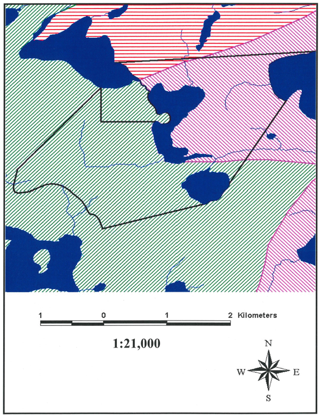
Appendix A. Regional setting of the Scotty Lake Conservation Reserve (C2361)
Enlarge Regional setting of the Scotty Lake Conservation Reserve map
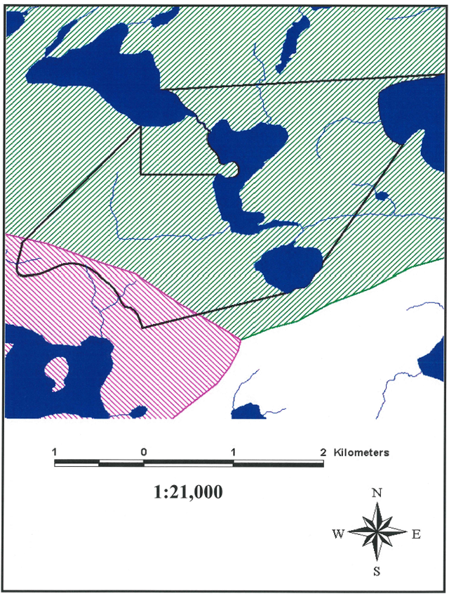
Appendix B. The Scotty Lake Conservation Reserve (and addition) boundaries
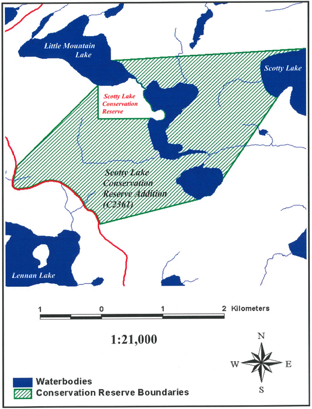
Enlarge Scotty Lake Conservation Reserve (and addition) boundaries map
Appendix C. The Scotty Lake Conservation Reserve life science checksheet (North-South Environmental Inc., 2000c)
Natural Heritage Area - Life science checksheet
Table of general information associated with Campfire River Conservation Reserve
| Name | Scotty Lake Conservation Reserve |
|---|---|
| Map Name | Lennan Lake |
| Map Number | 52 L/08 |
| UTM Reference | 420000 5576000 |
| County | Unorganized Area |
| Latitude | 50 25' |
| Longitude | 94 04' |
| NAD | 83 |
| Minimum Altitude | 320 |
| Maximum Altitude | 420 |
| Locality | Unorganized Area |
| Township | Unorganized Area |
| Area | 723 ha |
| Ownership | Crown Land |
| MNR Region | Northwest |
| Ecoregion and Ecodistrict | 4S2 |
| Landform Unit(s) | See attached table |
| MNR District | Kenora |
Physical and biological features
Table of physical and Biological Features
| Physical and biological features | Details |
|---|---|
|
Representation |
The major forest types represented in the reserve addition include extensive trembling aspen stands, Jack pine on thin soils over bedrock and, less common, mixedwood types with Jack pine, white birch, spruce, aspen and scattered white and red pine. Black spruce dominated types (upland or lowland) are uncommon. Wetland cover types include extensive Nymphaea odorata marsh, Eleocharis palustris shallow water marsh, Carex lasiocarpa marsh-meadows at lake shoreline, as well as classic sequences on creek floodplains (graminoid marsh? graminoid meadow? alder thicket swamp). Beaver are common in the area, damming the creek systems. Aquatics areas provide good habitat for moose feeding. |
|
Condition |
The vegetation communities in the addition appear to be in natural condition, with very little sign of human impact. A logging road at the western boundary of the addition creates a potential threat to its integrity. |
|
Diversity |
The forests and wetlands of the reserve addition are quite diverse and representative of local conditions, considering the small size. Wetlands, in particular, are composed of several physiognomic types and exhibit interesting zonation patterns. |
|
Ecological Considerations |
The wide range of forest and wetland habitats supports a considerable diversity of plant species. There are also important aquatic habitats, including moose feeding areas. Although small, the addition serves as an upland and stream corridor between ecosystems of the neighbouring lakes: Scotty, Dumpy, Lennan and a lake just east of Helder Lake. A logging road at the western boundary of the addition creates a potential threat to its integrity. The presence of talus slopes with their interesting flora, located just beyond the northern boundary, would justify moving the boundary northward and following the recognizable physiographic features (e.g. ridges, catch basins), instead of running in a straight line. This would also ensure a coherent hydrology and water flows within the reserve. |
|
Special Features |
The occurrence of both red and white pine as a constant admixture in most mixed stands is noteworthy. |
|
Major Information Sources |
Field survey (September 2000) |
|
Significance Level (Provincial/Regional/Local) and Brief Summary of Major Representative Values |
Regional significance owing to the presence of white and red pine stands. |
|
Date Compiled |
November 2000 |
|
Compiler |
Christopher Zoladeski, North-South Environmental Inc. |
Scotty Lake Conservation Reserve
Plot sampling methods follow those outlined in:
North-South Environmental Inc. 2000. Earth and Life Science Reconnaissance Survey. 14 Provincial Parks and Conservation Reserves in the Western Part of Northwestern Ontario: Summary Report to the Earth and Life Science Checksheets. 20pp.
Plot 1: 418516N 5575601N
Description: Medium aged conifer mixedwood of Jack pine, black spruce and birch. Canopy ±continuous, 20 m tall. Patchy tall shrub layer of Alnus crispa. Continuous low shrub layer (Vaccinium, Diervilla, Arctostaphylos). Continuous herb and moss layers. Moderate amount of downed logs.
Composition:
T:
- Pinus Banksiana 3
- Betula papyrifera 2
- Picea mariana 1
TS:
- Alnus crispa 2
- Betula papyrifera +
- Picea mariana +
LS:
- Vaccinium myrtilloides 3
- Arctostaphylos uva-ursi 2
- Diervilla Lonicera 2
- Abies balsamea +
H:
- Cornus canadensis 3
- Gaultheria procumbens 2
- Clintonia borealis 1
- Lycopodium annotinum 1
- Lycopodium complanatum 1
- Gaultheria hispidula 1
- Oryzopsis asperifolia +
- Melampyrum lineare +
- Linnaea borealis +
- Lycopodium clavatum +
M-L:
- Pleurozium Schreberi 4
- Dicranum polysetum 2
Plot 2: 421188E 5575979N
Description: Medium-aged stand. Canopy ±continuous. Well-developed shrub and herb layers. Fair amount of downed logs.
Composition:
T:
- Populustremuloides 3
- Pinus Banksiana 1
- Abies balsamea +
- Picea mariana +
TS:
- Coryluscornuta 3
- Viburnum Rafinesquianum 1
- Abies balsamea 1
- Picea mariana +
LS:
- Cornusstolonifera 2
- Viburnum edule 2
- Diervilla Lonicera 1
- Vaccinium myrtilloides 1
LS:
- Rubus pubescens 1
- Rosa acicularis +
H:
- Aster macrophyllus 2
- Cornus stolonifera 2
- Petasites palmatus 1
- Clintonia borealis 1
- Oryzopsis asperifolia 1
- Aralia nudicaulis 1
- Calamagrostis canadensis 1
- Aster ciliolatus +
- Pyrola asarifolia +
- Galium triflorum +
- Maianthemum canadense +
- Maianthemum canadense +
- Linnaeaborealis +
- Pteridiumaquilinum +
M-L:
- Brachythecium spp. 2
- Climaciumdendroides 2
Plot 3: 420918E 5576020N
Description: Located below beaver dam, on both sides of creek. Wet site, with the main and secondary channels flowing through it. Rich herb layer dominated by Calamagrostis.
Composition:
TS:
- Alnus rugosa 5
LS:
- Rubus pubescens +
- Rubus idaeus +
- Salix sp. +
H:
- Calamagrostis canadensis 5
- Viola sp. 1
- Carex sp. +
- Equisetum sylvaticum +
- Lycopodium obscurum +
- Triadenum Fraseri +
- Glyceria canadensis +
M-L:
- Sphagnum spp. 1
- Brown mosses 1
Plot 4: 420940E 5576020N
Description: Graminoid marsh dominated by Carex and Scirpus. Tussocky microtopography. Wet, periodically flooded site, water pools throughout.
Composition:
H:
- Carex cf. utriculata 4
- Scirpus cyperinus 3
- Calamagr. canadensis 1
- Eupatorium maculatum +
- Viola sp. +
- Epilobium sp. +
- Triadenum Fraseri +
- Dulichium arundinaceum +
M-L:
- Sphagnum sp. +
Other vegetation communities:Vallisneriaamericana in the creek.
Plot 5: 421050E 5576030N
Description: Graminoid wet meadow located on the creek’s floodplain. Forms wider or narrower zones between the Scirpus zone and Alnus thicket.
Composition:
H:
- Calamagrostiscanadensis 5
- Scirpuscyperinus 1
- Carex sp. 1
- Menthaarvensis +
- Lycopus uniflorus +
- Viola sp. +
- Eupatorium maculatum +
M-L:
- Mosses +
Species observed during 2010 site visit
Trees:
- Balsam Fir (Abies balsamea)
- Jack Pine (Pinus banksiana)
- Red Pine (Pinus resinosa)
- White Birch (Betula papyrifera)
- White Spruce (Picea glauca)
Shrubs:
- Beaked Hazel (Corylus cornuta)
- Bush Honeysuckle (Diervilla lonicera)
- Green Alder (Alnus viridis)
- Mountain Ash sp. (Sorbus sp.)
- Pincherry (Prunus pensylvanica)
- Rough Cinquefoil (Potentilla norvegica)
- Saskatoon sp. (Amelanchier sp.)
- Velvet-leaved Blueberry (Vaccinium myrtilloides)
- Willow sp. (Salix sp.)
Herbs, clubmosses and mosses:
- Bearberry (Arctostaphylos uva-ursi)
- Bunchberry (Cornus canadensis)
- Blue-beaded Lily (Clintonia borealis)
- Bracken Fern (Pteridium aquilinum)
- Canada Mayflower (Maianthemum canadense)
- Common Juniper (Juniperus communis)
- Fireweed (Chamaenerion angustifolium)
- Ground-cedar (Diphasiastrum digitatum)
- Labrador Tea (Thermopsis rhombifolia)
- Running Club-moss (Lycopodium clavatum)
- Schreber’s Moss (Pleurozium schreberi)
- Spreading Dogbane (Apocynum androsaemifolium)
- Starflower (Trientalis borealis)
- Stemless Lady’s Slipper (Cypripedium acaule)
- Stiff Club-moss (Lycopodium annotinum)
- Wild Sarsaparilla (Aralia nudicaulis)
- Wintergreen (Gaultheria procumbens)
Birds:
- Bald Eagle (Haliaeetus leucocephalus)
- Black-capped Chickadee (Poecile atricapillus)
- Brown Creeper (Certhia americana)
- Chipping Sparrow (Spizella passerina)
- Gray Jay (Perisoreus canadensis)
- Magnolia Warbler (Setophaga magnolia)
- Mourning Warbler (Geothlypis philadelphia)
- Nashville Warbler (Leiothlypis ruficapilla)
- Ovenbird (Seiurus aurocapilla)
- Ruby-crowned Kinglet (Regulus calendula)
- Swainson’s thrush (Catharus ustulatus)
- Turkey Vulture (Cathartes aura)
- Winter Wren (Troglodytes hiemalis)
- White-throated Sparrow (Zonotrichia albicollis)
Appendix D. The Scotty Lake Conservation Reserve earth science checksheet detail (North-South Environmental Inc., 2000b)
Scotty Lake Conservation Reserve
Field Work Completed: September 30, 2000
Protection history:
This reserve was identified under the provincial Lands for Life – Ontario’s Living Legacy Program. It was principally identified for its life science representation with no previous earth science significance assigned.
Setting:
Scotty Lake Conservation Reserve is located approximately 65 km northwest of Kenora. It is a small, dominantly interior, upland area between Scotty lake and Lennan Lake to the southwest. It includes small portions of the shorelines of each lake and contains two small unnamed lakes which form part of the headwater to Scotty Lake. The reserve is quite rugged with up to 100 m of relief over relatively short distances.
There are currently no human impacts within the extent of the reserve however forest harvesting in encroaching from the south. A logging access road forms the southwestern boundary of the reserve and the construction of the road resulted in sand and gravel extraction from glaciofluvial deposits along the reserve boundary.
Earth science features:
The summary report prepared in conjunction with this checklist provides an overview of the bedrock geology and surficial geology history and representation of this reserve and should be consulted for more information (North-South Environmental Inc. 2000). Detailed site information collected during the reconnaissance field surveys is provided on the attached table and in the accompanying site photographs. A map of the surficial geology also accompanies this checklist (prepared from Northern Ontario Engineering Geology Terrain Study Map 5106).
Bedrock geology:
The bedrock of the study area consists of foliated to massive tonalite and granodiorite representing the Winnipeg River Subprovince of the Superior Province (Neo to Mesoarchean - 2.5 to 3.4 billion years old). Within the reserve, rock types are principally granites and granodiorites which are already well represented within parks and reserves of Northwestern Ontario.
Surficial geology:
Although the reserve is quite small, it has an interesting array of earth science features and landform complexes. Earth science features of interest include two high cliffs, a deep relict erosional channel, and a boulder lag deposit. Landform complexes within the reserve include glaciofluvial terrace aprons (field site #1), thin ground moraine (field site #3) and deep glaciolacustrine basin (field site #2) deposits draping and in-filling moderately broken bedrock topography.
The two cliffs are quite prominent and have talus accumulations. They are in proximity to each other at the northern edge of the reserve (field sites A Site1 and A Site2 on accompanying table and photos). The southerly cliff is currently within the reserve (A Site1) but the other cliff, which is also higher and wider, lies just to the north of the reserve boundary.
The boulder lag slope supports a significant red pine stand. It occurs on a prominent slope north of Lennan Lake (A Site3). It was likely created by the wave action in glacial Lake Agassiz removing the fine materials from a glaciofluvial deposit.
The relict erosional channel occurs between field sites #2 and #3 (see aerial view in accompanying photos and diagram, below). The south side of the channel is formed in deep glaciolacustrine silty clays deposited as deep basin sediments in glacial Lake Agassiz. A bedrock slope with a thin veneer of ground moraine forms the northern slope of the channel. The floor of the channel is currently occupied by a small underfit creek. Numerous large boulders have moved down the northern slope onto the surface of the clay at the base of the channel. Because the channel is partially cut into the clay, it is likely this marks a former east-west drainage channel of glacial Lake Agassiz.
Because there is no evidence of subsequent sedimentation within the channel, this would represent the last drainage of the glacial lake in this area which would be the transition from the Emerson high water phase to the Nipigon low water phase (Barnett 1992, pg 1056).
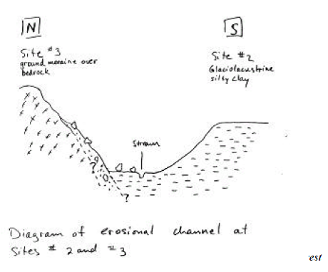
Enlarge diagram of erosional channel at site #2 and #3
Sensitivity:
The features and landform complexes in this reserve are generally not sensitive to human impact with the exception of the glaciofluvial terraces/aprons adjacent to the southwestern boundary road. These have already been impacted by gravel extraction for road construction. Further extraction activities in this area should be prevented.
Significance:
The reserve has some earth science significance for the range of features and deposits occurring within a small area, particularly the two high cliffs at the northern boundary. The boulder lag slope has some specific significance representing erosional processes in glacial Lake Agassiz.
The erosional channel is ranked is regionally significant because it represents a particular phase of glacial Lake Agassiz which is otherwise poorly represented in parks and reserves. Drainage channels associated with this glacial lake are mostly recognized and mapped in the vicinity of its major outlets (e.g. Lake Nipigon area) and are rare within the main basin of the lake. The assigned significance relates to its perceived scientific, interpretive and educational values, however this is pending further field studies to confirm (or not) the interpretation presented here.
Recommendations:
Further earth science field work is recommended to fully document and map the erosional channel and other features or deposits which may be related to events during the transitional stage of glacial Lake Agassiz. The interpretation presented in this checklist should be considered tentative pending further studies.
The northern boundary of the reserve should be extended to the north in order to capture the second cliff and talus feature. The recommended addition is shown on the attached surficial geology map.
Given the earth science complexity within this small reserve, additional reconnaissance aerial photograph and field studies should be undertaken in the area surrounding the reserve to determine potential additional representation.
Appendix E. The boundaries of the Bear Management Areas represented within the Scotty Lake Conservation Reserve
Appendix F. The boundaries of the two traplines represented within the Scotty Lake Conservation Reserve
Appendix G. Areas of wildlife significance within the Scotty Lake Conservation Reserve