Searchmont South Forest Conservation Reserve Management Statement
This document provides policy direction for the protection, development and management of the Searchmont South Forest Conservation Reserve and its resources.
(C289)
Statement of Conservation Interest
Ministry of Natural Resources
Algoma Area
Sault Ste. Marie District
January 10th, 2003
Ce document est seulement disponsible en anglais.
Sault Ste. Marie District
Ministry of Natural Resources
Approval statement
I am pleased to approve this Statement of Conservation Interest (SCI) for the Searchmont South Forest Conservation Reserve (C289), prepared by Marjorie Hall.
Searchmont South Forest Conservation Reserve captures spectacular ridges, cliff faces, and creek habitats associated with Dam Creek valley. The site protects a variety of forest communities, including an old growth yellow birch (Betula alleghaniensis Britt.) - sugar maple (Acer saccharum Marsh.) mixed-wood community located along a ridge in the southern portion of the site. Regulated on April 6, 2001, this 626 hectare conservation reserve is situated approximately 40 kilometres northwest of the City of Sault Ste. Marie in Hodgins Township.
Direction for establishing, planning and managing conservation reserves is defined under the Public Lands Act and current policy. The direction for managing this conservation reserve is in the form of a SCI, which defines the area that is being planned, provides the purpose for which the conservation reserve was proposed, and outlines the Ministry of Natural Resources' intent for the protected area. This SCI will provide both guidance for the management of the conservation reserve and the basis for ongoing monitoring of activities. More detailed direction at this time is not anticipated. However, should significant facility development be considered or complex issues arise requiring additional studies, more detailed management direction in the form of special protection measures, or a detailed Resource Management Plan, will be prepared with full public consultation.
Public and Aboriginal consultation occurred prior to the regulation of this conservation reserve during the planning for Ontario’s Living Legacy. Furthermore, there was a 15-day review period in November 2002 concerning a draft of this SCI. Comments from the review period have been considered in the development of this document.
This SCI will be implemented by the Algoma Area Supervisor, and will be reviewed every five years and amended as required by the District Planner, Sault Ste. Marie District, Ministry of Natural Resources.
Submitted by: Erin Nixon
Date: February 21, 2003
Recommended
For Approval by and signed:
Serge Tenaglia, R.P.F.
District Manager
Sault Ste. Marie
Date: March 4, 2003
Signed and approved by:
Rob Galloway
Regional Manager
Northeast Region
Date: May 30, 2003
1.0 Introduction
The following document is a Statement of Conservation Interest (SCI) for the Searchmont South Forest Conservation Reserve (C289). The purpose of this SCI is to identify and describe the natural, recreational and cultural values of the Searchmont South Forest Conservation Reserve and to outline the Ministry of Natural Resources' management intent for this area. The first portion of this document highlights the provincial context in which it was produced, states its goals and objectives, and summarizes the planning process for conservation reserves. The second portion of this document is specific to the Searchmont South Forest Conservation Reserve. Management direction provided within this SCI will serve to protect the conservation reserve for the benefit of all Ontario residents. This direction will comply with the land use intent stated in the Ontario’s Living Legacy Land Use Strategy (OMNR 1999).
1.1 Provincial context
Ontario’s network of natural heritage areas has been established to protect and conserve areas representative of the diversity of the natural regions of the province, including species, habitats, features and ecological systems which comprise that natural diversity. Protected natural heritage areas are a key component in the sustainable management of natural resources. They ensure that representative sites within the larger managed landscape are permanently retained in their natural state. Searchmont South Forest Conservation Reserve is part of Ontario’s network of natural heritage areas.
On July 16, 1999, the Ontario Government released the Ontario’s Living Legacy Land Use Strategy to guide the planning and management of Ontario’s Crown lands. Extensive consultation was conducted during the development of the Land Use Strategy. The objectives of the Land Use Strategy are to complete Ontario’s system of parks and protected areas; recognize the land use needs of the resource-based tourism industry; provide forestry, mining and other resource industries with greater certainty around land and resource use; and enhance hunting, angling and other Crown land recreation opportunities.
The Land Use Strategy (OMNR 1999) demonstrated the government’s commitment to completing Ontario’s system of protected natural heritage areas by designating 378 new areas to be protected. These areas are considered to be significant and require protection from incompatible activities in order for their values to endure over time. The addition of these 378 new areas marks the largest expansion of parks and protected areas in Ontario’s history. Searchmont South Forest Conservation Reserve was created as part of this expansion. It protects landform features associated with the Dam Creek valley, including an old growth yellow birch (Betula al/eghaniensis Britt.) - sugar maple (Acer saccharum Marsh.) mixed-wood community located along a ridge in the southern portion of the site.
The Ministry of Natural Resources has established conservation reserves as a tool to protect natural heritage areas on public lands, while permitting traditional public land uses to continue. These uses include recreational activities, such as hunting and fishing, and the traditional activities of Aboriginal societies as defined under applicable Aboriginal Treaties. Lands designated as conservation reserves in the Land Use Strategy (OMNR 1999) have been removed from the Sustainable Forest License, and mining and surface rights are withdrawn from staking under the Mining Act (RSO 1990 Chapter M.14).
Ontario’s Living Legacy Land Use Strategy outlines the general land use policy and management direction for new conservation reserves. Each new conservation reserve will have a planning document that details site-specific management direction.
2.0 Goal and objectives of the SCI
2.1 Goal
The goal of this SCI is to provide the framework and the direction to guide management decisions affecting Searchmont South Forest Conservation Reserve.
2.2 Objectives
The following objectives are identified as the means to achieve the above stated goal:
- To describe the state of the resource with respect to the values identified in Section 5.0, and current land use activities
- To outline the Ministry of Natural Resources' management intent for the protected area
- To determine the land use compatibility of current land uses, and to develop specific guidelines and prescriptions to manage these uses
- To create public awareness of the values, as per Section 5.0, within this conservation reserve by providing information on the resources that it contains and protects; and to promote responsible stewardship of the protected area through partnerships with local stakeholders
- To determine the long-term management goals for the conservation reserve by identifying research, client services, and marketing strategies necessary to position this conservation reserve among the system of parks and protected areas in Ontario
- To identify the scientific values of the site in relation to provincial benchmarks and identify the necessary monitoring and/or research to maintain the integrity of those values
- To provide direction for the evaluation of proposed new uses or economic ventures through the application of the Test of Compatibility (Appendix A). This test will evaluate the impact of suggested use(s), either positive or negative, on the protected values of the conservation reserve
3.0 Management planning
3.1 Planning for a conservation reserve
The planning process for a conservation reserve consists of defining site boundaries and preparing a site specific management plan. Public, Aboriginal and industry consultations occur during the planning process. When the boundaries of the site are finalized and the Ministry of Natural Resources' approval process is complete, a conservation reserve becomes regulated. Once a conservation reserve is regulated, the level of management planning required to fulfil the protection targets is determined, and either a basic or an enhanced SCI or a Resource Management Plan is prepared. A basic SCI is prepared when land use direction follows the direction laid out in the Ontario’s Living Legacy Land Use Strategy (OMNR 1999). An enhanced SCI is prepared when minor variations to the directions occur, beyond those mentioned in the Strategy. A Resource Management Plan is prepared in more complex situations where a number of issues have to be addressed. Whichever the determination, the plan must be completed within three years of the conservation reserve’s regulation date. The guidelines for the preparation of these documents are provided in Procedural Guidelines A - Resource Management Planning (Conservation Reserves Procedure PL3.03.05, Public Lands Act).
A SCI is essentially a management plan, based on the management direction provided in the Land Use Strategy (OMNR 1999). The purpose of a SCI is to identify the state of the resource with respect to values (Section 5.0) and current land use activities, and to outline the Ministry of Natural Resources' management intent for the conservation reserve. SCIs typically go through a public review period of 15 days. Upon completion of this public review, the SCI is revised as appropriate and approved by the Ministry of Natural Resources' Regional Director.
Existing permitted uses within conservation reserves may continue, unless they are shown to have a significant negative impact on the values protected by the site. A review/evaluation mechanism is in place to address proposed new permitted uses, or land use proposals. The Test of Compatibility as outlined in the Public Lands Act Policy PL 3.03.05 (OMNR 1997) and/or other standard Ministry of Natural Resources' environmental screening processes, is used to screen future proposals. Where cultural resources may be impacted, proposals may be screened through Conserving a Future for our Past: Archaeology, Land Use Planning & Development in Ontario, Section 3 (MCzCR 1997), in a manner similar to that used by the Ministry of Natural Resources in the forest management planning process.
Public comment may be solicited during a review of any future land use proposals that require new decisions to be made. Appropriate environmental assessment {EA) requirements and amendment processes will apply to any future proposals and/or any significant change in management direction being considered for a site.
3.2 Planning process for the Searchmont South Forest Conservation Reserve
The Searchmont South Forest Conservation Reserve (C289) was proposed as a conservation reserve in the 1999 Ontario Living Legacy Land Use Strategy by the Ministry of Natural Resources. Public, Aboriginal and industry consultation has taken place and the boundary of the site has been finalized. The site was formally regulated through an amendment to Ontario Regulation 805/94 of the Public Lands Act on April 6, 2001 by Ontario Regulation 86/01.
To date, no significant issues related to land use in this area have been identified. For this reason, it was determined that a basic SCI will adequately identify the conservation reserve’s significant features and address the management guidelines. Therefore, the Searchmont South Forest Conservation Reserve will be managed under the auspices of a SCI. It should be noted that this SCI addresses only those issues or land use proposals currently known to the District Manager. The direction provided by this SCI, and future management decisions, will resolve any future land use conflicts and will ensure that identified values continue to be adequately protected.
3.2.1 Planning area
The planning area for this SCI consists of the regulated boundary for the Searchmont South Forest Conservation Reserve (see Section 10.0, Maple). However, to fully protect values within the conservation reserve, additional consideration within larger land use planning initiatives may be required. The forest management planning process is an example of how adjacent land management may consider sensitive features within the conservation reserve boundary.
3.3 Guiding principles
All current or planned activities within this conservation reserve should be in compliance with the following guiding principles. If a conflict between management guidelines exists, the following guiding principles will be used to discern management intent and resolve the issue:
- All management guidelines will be based on maintaining the long-term ecological integrity of the area
- No new or existing uses will be permitted if it is deemed that they compromise the protected values
- All attempts will be made to maintain traditional uses while protecting the values identified in Section 5.0 and maintaining the long-term ecological integrity of the site
- This conservation reserve was chosen to represent vegetation and landscape types unique to this site district and to Ontario. All efforts will be made to maintain those values identified in Section 5.0
- Overall, management strategies will focus on maintaining the conservation reserve in as natural a state as possible
4.0 Background information
4.1 Location and site description
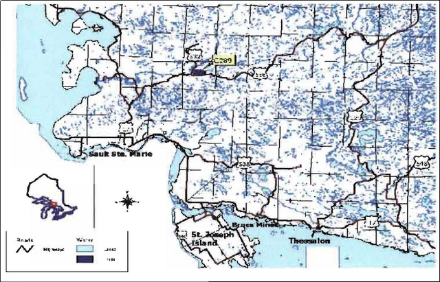
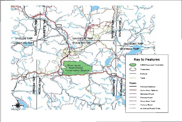
Searchmont South Forest Conservation Reserve is located approximately 40 km northeast of the City of Sault Ste. Marie, in Hodgins Township. The site is situated south of the community of Searchmont and east of the Algoma Central Railway (Section 10.0, Map la). Whenever possible, natural and/or artificial features have been used to delineate site boundaries to facilitate easy on-the-ground identification of the boundaries.
Ranger Lake Road forms the boundary on the south side of the conservation reserve and the Algoma Central Railway line forms the southern half of the site’s west boundary. These transportation corridors provide easy access to the site’s south and southwest sectors. The northern portion of the west boundary and the entire north boundary follow the limits of adjacent private land. The remaining boundary sections are primarily vectored, i.e. straight lines between two points. A small segment in the northeast follows a road and another small segment in the southeast follows short sections of both Dam and Stoney Creeks.
While Dam Creek runs from east to west across the southern portion of the site, the navigability of this waterway is unknown. A portion of the Searchmont Resort ski-trail network runs through the northwest section of the conservation reserve and this allows some access to this sector. In general, however, the site’s rugged topography and roadless terrain make access into the interior a challenge.
Table 1 describes the location and provides administrative details for the site.
| Name | Searchmont South Forest Conservation Reserve (C289) |
|---|---|
| Site Region - Site District (Hills, 1959) | 4E-2 Batchawana |
| Site Region - Site District (Crins and Uhlig, 2000) | 5E-13 |
| OMNR Administrative Region/District/Area | Northeast Region/Sault Ste. Marie District/Algoma Area |
| UTM co-ordinates | 266138 E 5191413 N |
| SCI Completed | January 10 2003 |
| Regulated | April 6 2001 |
| Area | 626 ha |
| Nearest Town/Municipality | Approximately 3 km south of the hamlet of Searchmont and approximately 40 km northeast of the City of Sault Ste. Marie |
| Township | Hodgins |
| OBM Numbers | 2016720051800 |
| Topographical Map Name/Number | 41K/16 Searchmont 41K/9 Sault Ste. Marie |
| Wildlife Management Unit | 36 |
| Forest Unit | Algoma |
Table 1. Location and administrative details for the Searchmont South Forest Conservation Reserve.
4.2 History of the site
Logging mills and forestry operations have played a substantial role in the history of the Searchmont South Forest Conservation Reserve. Hope Lumber Mill was located along the railway line at Glendale and operated during the late 1800s. The mill was situated within the present-day conservation reserve, just northeast of the intersection of Ranger Lake Road and the Algoma Central Railway (T. Latulippe, pers. comm.). The foundation of the mill is still in evidence today (J. Miller, pers. comm.).
By 1912, Glendale was the scene of extensive lumber operations ranging many miles from the railway (Vosper 2000). During this era, it can be assumed that a large portion of the forest within the Searchmont South Forest Conservation Reserve was harvested. The white pine (Pinus strobus L.) harvested from the area was used to supply the mill at Glendale, whereas any hardwood harvested was shipped to mill operations in Sault Ste. Marie (Vosper 2000). Mixed hardwood forests, which re-establish more readily than pure pine stands, replaced much of the original white pine forest in this area (Vosper 2000).
In 1902, a charcoal plant was constructed near the community of Searchmont. During the charcoal plant’s short existence, it required 25 acres (10 hectares) of harvested forest daily to fuel its operations (Vosper, 2000). This timber requirement was obtained from the Searchmont area. Once the charcoal was created, it was shipped by rail to the Algoma Steel Mill in Sault Ste. Marie for use in the blast furnaces (Vosper, 2000). Early problems with charcoal use resulted in the re-engineering of furnaces to handle coke (processed coal) and, in turn, the Searchmont charcoal plant was abandoned.
4.3 Inventories
Table 2 indicates the current status of natural heritage inventories that have occurred and/or are required for Searchmont South Forest Conservation Reserve.
| Survey Level | Earth Science | Life Science | Cultural | Recreational |
|---|---|---|---|---|
| Reconnaissance | Fall 200 | Fall 200 | Fall 200 | Fall 200 |
| Detailed | Not required | Representation within the site district, region and province still needs to be evaluated. | Not required | Not required |
| Further requirements | Future ground survey should be considered to confirm presence of Braun’s holly fern (Polystichum northeast section braunii) | Confirmation of the location and condition of the abandoned road located in the northeast section of the site should be completed. |
Table 2: Inventory and Survey Information for the Searchmont South Forest Conservation Reserve
5.0 State of the resource
Air photo interpretation coupled with an aerial survey and a site visit have indicated that Searchmont South Forest Conservation Reserve is in good to moderate condition. During the aerial survey, Lajeunesse and Thompson (2002) noted a small disturbance in the far southwest corner of the site along the Algoma Central Railway line. The disturbed area is associated with the railway and contains an open grassy area, trails, and deciduous shrubs and tree species. It is possible that this disturbed area is the location of the historic Hope Lumber Mill.
While the site itself is relatively undisturbed, the Ranger Lake Road to the south, the Algoma Central Railway and some private land to the west and north, artificially separate the site from the forest communities extending in these directions, leading to ecological fragmentation. In addition, the site’s small size and adjoining patent land could make the long-term management and protection of the core values problematic.
The key values (geological features and/or featured species) found within Searchmont South Forest Conservation Reserve include the following:
- An old growth yellow birch/sugar maple mixed-wood community, found along the ridge in the southern portion of the conservation reserve
- Spectacular cliff faces, located in the western and southeast portions of the site
- The landforms, forest communities and creek habitats associated with the Dam Creek valley area
The key values are those values that make this site unique and have led to its designation as a conservation reserve. Their protection is paramount. Additional values as listed in Sections 5.1 through to Section 5.5 are also important. This description is not necessarily complete. If new values are identified, they will be added to this section. If any new value is considered significant, management guidelines may be modified, if required, to ensure its protection.
5.1 Earth Sciences
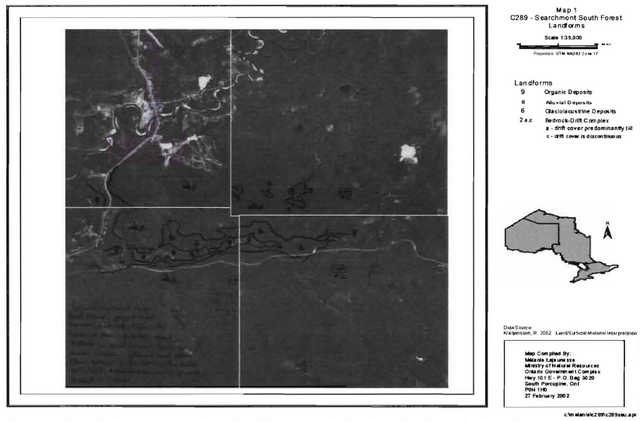
Searchmont South Forest Conservation Reserve is located in a very scenic area of Ontario. Situated approximately 30 kilometres inland from the Lake Superior coastline, this site falls within the Batchawana Site District 4E-2 (Hills 1959). This site district is known for its rugged topography. The landform features in this site district are the result of numerous geological structures such as faults, joints, and diabase dikes that dissect the area (Lajeunesse and Thompson 2002). In this region, the bedrock uplands have a thin layer of sandy soil on slopes and deeper soils in the valleys. Exposed bedrock is common and dates back billions of years to the Precambrian and Cambrian periods.
Kristjansson (2002, in prep.) has completed an assessment of landform features within the Searchmont South Forest Conservation Reserve, based on air-photo interpretation. The conservation reserve was found to have five major landform types: organic deposits, glaciolacustrine deposits of silt and clay, till deposits, bedrock-drift complex, and alluvial deposits (Lajeunesse and Thompson 2002). Bedrock-drift complex, predominately composed of till and discontinuous material, dominates the site. Glaciolacustrine deposits fringe the western and southern portion of the conservation reserve, along the Goulais River and Dam Creek (Section 10, Map 2).
5.2 Life sciences
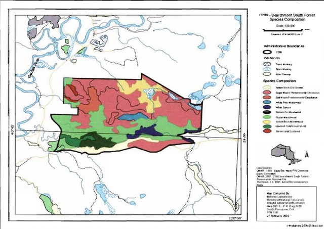
Based on information gathered from aerial surveys, air-photos and Forest Resource Inventory data, Lajeunessse has determined that tolerant hardwood trees characterize Searchmont South Forest Conservation Reserve. Bedrock landforms north of the Dam Creek are dominated by mixed stands of sugar maple stands and yellow birch (Lajeunesse and Thompson 2002). Poplar (Populus spp.) dominated mixed-wood communities are the characteristic vegetation type throughout the southern half of this conservation reserve. The south part also contains dense sugar maple and yellow birch communities mixed with a wide variety of tree species, including red maple (Acer rubrum L.) white cedar (Thuja occidentalis L.), hemlock (Tsuga spp.) and white pine (Pinus strobus L.) (Section 10, Map 3a). Most of the forest communities within the southern portion of the site are considered to be mature, ranging in age from 102 to 150 years old, with stocking estimated in the range of 70 to 100 percent (Lajeunesse and Thompson 2002).
The forest vegetation along the banks of Dam Creek is predominately semi-open conifer and deciduous shrub, creek bank forest. The forest community contains balsam fir (Abies balsamea (L.) Mill), white spruce (Picea glauca (Moench) Voss) and white cedar stands. Two scattered coniferous lowland forest stands of white spruce, balsam fir and alder (Alnus spp.) associated with the alluvial deposits along Dam Creek, become thicker as one moves from west to east (Lajeunesse and Thompson 2002). West of the junction of Dam Creek with its northern tributary, a white pine mixed-wood community colonizes the exposed bedrock face of a large ridge while maple hardwoods dominate the base of the ridge. Here, the coniferous dominated creek banks give rise to mainly poplar communities along the north bank, and a sugar maple and yellow birch dominated community along the south bank.
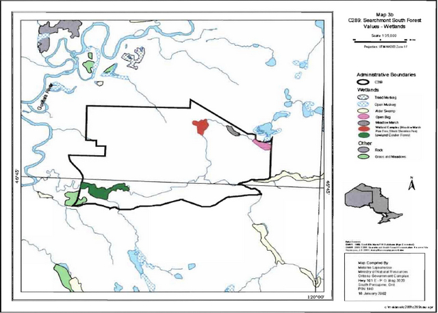
The main organic deposits within the conservation reserve are associated with a series of wetlands, located in the southwest and northeast portions of the conservation reserve. They contain an open bog, meadow marsh, and wetland complex of meadow marsh, poor fen and shrub shoreline fen (Lajeunesse and Thompson 2002). Eastern white cedar, tamarack (Larix spp.), black spruce (Picea mariana (Mill.) BSP), willow shrubs (Salix spp.) and bluejoint grass (Calamagrostis canadensis) are contained within the larger wetland complex in the southwest portion of the site (Section 10, Map 3b).
Braun’s Holly Fern (Polystichum braunii), a provincially significant plant species, has been recorded within the conservation reserve (Knudsen pers. com.). Braun’s Holly Fern often grows on rocky slopes and moist cliffs in deciduous woods. It requires cool shaded areas to grow and is sensitive to logging activities (Wisconsin Department of Natural Resources 2001).
Bird surveys completed within the conservation reserve from 1999 to 2001 have identified a full complement of songbird species, including the wood thrush (Hylocichla mustefina) (Knudsen pers. com.). The Searchmont area is on the northern extent of the wood thrush’s breeding range (Cadman et al. 1986), and significant declines in wood thrush populations have been noted throughout North America (Georgia Museum of Natural History 2000).
The Searchmont South Forest Conservation Reserve is situated in the Lake Superior Basin watershed. At present, fisheries information is limited. However, rainbow trout (Oncorhynchus mykiss) have been caught in Dam Creek (E. Murphy pers. com.), and a walleye (Stizostedion vitreum) spawning area has been identified on the Goulais River north of the conservation reserve. No known artificial dams exist within or upstream of the conservation reserve.
The Goulais River, to the south and east of the conservation reserve, has historically supported a population of wood turtles (Ciemmys insculpta) (R. Knudsen, pers. com.). The Committee on the Status of Endangered Wildlife in Canada (COSEWIC) (2002) classifies the wood turtle as a Species of Special Concern, indicating it has characteristics that make it particularly sensitive to human activities or natural events. Tributaries of the Goulais River, such as Dam Creek, have the potential to support small groups of wood turtles.
5.3 Recreational values
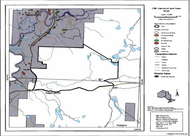
Recreational activities are abundant within the Searchmont South Forest Conservation Reserve and surrounding area, due to the presence of Searchmont Resort just north of the conservation reserve. The resort offers a wide variety of recreational opportunities including downhill and cross-country skiing. A portion of Searchmont Resort’s cross-country ski trail network falls within the northwest section of this conservation reserve. Currently, this is the only known trail system located within the conservation reserve (Section 10, Map 4).
The southern and western boundaries of the conservation reserve are easily accessible. Ranger Lake Road forms the entire southern boundary of the conservation reserve and the Algoma Central Railway tracks form part of the western boundary. Due to steep and rugged terrain, the interior of the site is more difficult to access. Dam Creek could potentially be used to access part of the interior of the conservation reserve.
Dam Creek runs predominately east to west through the southern portion of the conservation reserve. This meandering creek is very picturesque with a gravel creek bed and periodic rapids. After completing an aerial reconnaissance flight, Nathwani (2002) reported that Dam Creek may provide opportunities for canoeing and kayaking, depending on sufficient water levels. However, a site visit completed during the late summer in 2002 did not support these observations (Hall, 2002). During the peak water flow conditions of spring, it may be possible to navigate the creek by canoe or kayak, but this is yet to be confirmed.
The site has a high potential for nature appreciation activities. The combination of the creek, wetlands, forested ridges and plains all add to the beauty of the Searchmont South Forest Conservation Reserve. A unique recreational feature associated with this site is an undeveloped roadside pull-off along the Ranger Lake Road, which overlooks the conservation reserve (Section 10.0, Map 1c). This area, created as a by-product of road upgrades by the Ministry of Transportation (MTO) (T. Latulippe per. com.), is currently used as a stop on the Algoma Forest Coalition’s field tour (Algoma Forest Coalition 2002) and has the potential to be used as a viewing point for visitors to the conservation reserve. Fall colours highlight this vista, and the development of interpretative panels would add an educational dimension to this beautiful lookout. Hunting and fishing activities are also known to occur within this conservation reserve (Hall 2002).
5.4 Cultural values
Currently, the only known cultural feature within this site is the historic location of the Hope Lumber Mill. Please see Section 4.2 for more information on the site’s history.
The site falls within the Robinson-Huron Treaty area. To date, no First Nation community has identified any specific cultural values within this conservation reserve.
5.5 Research values
Searchmont South Forest Conservation Reserve contains two bird-monitoring plots, established by Robert Knudsen (2001), as part of the Ministry of Natural Resources' Forest Songbird Monitoring Project. These plots were monitored during the spring of 1999, 2000 and 2001. Currently, no other research activities are known to have occurred within this conservation reserve.
An Ontario Nocturnal Owl Survey route is located along Ranger Lake Road, but does not enter into the conservation reserve. The Ontario Nocturnal Owl Survey program was initiated in 1995 by Bird Studies Canada in partnership with the Wildlife Assessment Program of the Ontario Ministry of Natural Resources (Bird Studies Canada, 2003). The primary goal of this survey is to monitor owl populations in Ontario to determine whether owls are being affected by logging practices.
6.0 Management guidelines
All management guidelines in this SCI are based on policy and direction outlined in the Ontario Living Legacy Land Use Strategy (OMNR, 1999) and associated policy clarification statements. Management policies in this document may be subject to change and may be amended as necessary. These guidelines are specific to Searchmont South Conservation Reserve, and provide for protection of the site’s unique features.
New proposals for uses and development, as well as research and education, will be reviewed on a case-by-case basis. The Test of Compatibility (Appendix A - PL 3.03.03, Public Lands Act) must be passed with reference to Conserving a Future for our Past: Archaeology, Land Use Planning & Development in Ontario, Section 3 (MCzCR 1997) before new proposals will be permitted. In addition, new proposals are subject to the Class Environmental Assessment for Parks and Conservation Reserves.
The following management strategies have been created to achieve the goal and objectives of the Searchmont South Forest Conservation Reserve SCI.
6.1 Industrial activities
6.1.1 Commercial timber harvest
The area contained within this conservation reserve (626 ha) has been withdrawn from the Algoma Sustainable Forest License area and commercial timber harvesting is not permitted. Please refer to Section 6.4.3 for information regarding non-commercial wood harvesting.
6.1.2 Mining and mineral exploration
There are no known current mining interests within this conservation reserve. Mining and surface rights within the conservation reserve’s boundaries have been withdrawn from staking under the Mining Act (RSO 1990 Chapter M.14). Mineral exploration is not permitted.
6.1.3 Extraction of peat, soil, aggregate and other material
Extraction of peat, soil, aggregate and other materials is not permitted.
6.1.4 Energy generation
Hydropower development and windpower generation is not permitted within the conservation reserve.
6.2 Existing and proposed development
6.2.1 Transportation corridors
6.2.1.1 Roads
According to the Land Use Strategy (OMNR 1999), new roads for resource extraction will not be permitted, except for those identified in Forest Management Plans prior to March 31, 1999. No new or existing roads for resource extraction were identified within this site.
Ranger Lake Road forms the southern boundary of the conservation reserve. Co-operation will be sought to minimize impacts to the conservation reserve during road maintenance and upgrades. An abandoned road enters the northeast corner of the site leading to an unnamed lake, however the current state of this road has not been assessed. Existing Crown roads that are contained within this conservation reserve are permitted to continue but will not be maintained by the Ministry of Natural Resources. Maintenance by area users may be permitted, subject to appropriate approvals to ensure the protected values of the site are not compromised. Should protected values of the site be compromised, the Ministry of Natural Resources may consider appropriate provisions under the Public Lands Act to ensure their protection.
6.2.1.2 Trails
Existing authorized trails can continue unless there are significant demonstrated conflicts. Presently, a portion of the Searchmont Resort cross-county ski trail system is located in the northwest section of the conservation reserve (Section 10, Map 4). This trail is permitted to continue for cross-country skiing as well as other associated off-season, low-impact activities.
Currently, no Voyageur Trail Association or Ontario Federation of Snowmobile Clubs trails have been identified within this conservation reserve. Any future trail development must consider the conservation reserve’s core values, specifically the earth science features that are protected within the boundaries of this site. Trail development in low-lying areas and wetlands will be discouraged as will trail development over shallow soils on rock outcrops and the fragile vegetation that grows on these sites. Any proposed new trails will be subject to the district work permit review process and the Test of Compatibility screening process (Appendix A). All new and existing trail heads and trail routes must be identified using new technologies (i.e. global positioning systems) to ensure the most accurate record of the feature. If new trails are approved, an amendment to this SCI will occur.
6.2.2 Other corridor development/maintenance
No communication, energy transmission, or other non-road corridors are located within this conservation reserve. New corridor developments will be actively discouraged through planning. Proposals for new corridors will be subject to the Test of Compatibility (Appendix A) and other applicable district policies.
6.2.3 Land disposition
No land will be sold within the boundaries of this conservation reserve.
6.2.4 Land tenure
Presently, no Land Use Permits (LUPs) or leases exist within this conservation reserve. With the exception of private recreation camps, new leases or land use permits may be issued for other approved uses, subject to the Test of Compatibility (Appendix A) and applicable district policies. These forms of land tenure will neither be patented nor phased out but may be eligible for enhanced tenure or transfer. Enhanced tenure is defined as anything beyond the term and form of current tenure. All requests for transfer or enhanced tenure will be subject to the following screening criteria:
- Is the transfer or enhanced tenure consistent with the conservation reserve’s land use intent, which is the protection and enhancement of the site’s natural, recreational and cultural values?
- Is it consistent with the land disposition policies outlined in the District Land Use Guidelines, the Crown Land Use Atlas, this SCI and any other applicable document?
- Does it adversely affect protected the values as identified in Section 5.0, and/or conflict with other uses?
- Is land needed by the Crown to protect significant natural or recreational values outlined in this SCI?
- Does the transfer or enhanced tenure conflict with Aboriginal traditional uses, land claims or agreements?
- Are all rents, taxes, fees, rates or charges paid up for the existing LUP or lease?
6.3 Commercial activities
6.3.1 Commercial bait harvesting
No active commercial bait harvest operations or licences currently exist within this conservation reserve. However, Hodgins Township has been set aside for First Nation commercial bait harvest. At this time it is not known whether a local First Nation community or individual First Nation members, will obtain a commercial bait harvest licence in this township. New operations can be considered within the conservation reserve subject to the Test of Compatibility (Appendix A) and applicable district policies.
Under the Public Lands Act and in conjunction with PL 3.03.08 "Buildings for Bait harvesting Management", cabins for the purposes of bait harvesting may be constructed on Crown land. However, the approval of such buildings within this conservation reserve should be avoided, and Crown land outside of the protected area used wherever possible.
6.3.2 Commercial fishing
There are no commercial fisheries within this conservation reserve.
6.3.3 Commercial fur trapping
A portion of the registered trapline area SS35 falls within the boundary of this conservation reserve. This registered trapline area is currently allocated to a head trapper. If a head trapper surrenders a registered trapline, or the head trapper’s privileges are revoked, the registered trapline may be transferred to another trapper following established allocation procedures. If the registered trapline is not transferred in due course, or remains unallocated for a significant period of time, reallocation of the trapline may occur following applicable district screening processes.
The establishment of new trapline trails will be considered following the procedure and criteria for new trails as outlined in Section 6.2.1.2. No trap cabin currently exists within the conservation reserve. The establishment of new trap cabins is not permitted within conservation reserves.
6.3.4 Bear management areas
This conservation reserve is located within Bear Management Area (BMA) SS-36-005. Guided hunting activities associated with a BMA may continue within this conservation reserve. Transfer of the BMA within this conservation reserve may be permitted in cases where the current operator sells his/her bear hunting business to another operator and the BMA transfer is approved. If an operator surrenders the BMA or the BMA is revoked, reallocation of the BMA may occur following applicable district screening processes.
6.3.5 Commercial food collection
There are no existing commercial food harvesting ventures within the site. New ventures will be subject to the Test of Compatibility (Appendix A) and the appropriate Ministry of Natural Resources' policies and procedures.
6.3.6 Non-forest timber products
Policy is currently being developed by the Planning and Research Section of Ontario Parks regarding commercial non-timber forest products. In the interim, proposals will be reviewed on a case-by-case basis, subject to the Test of Compatibility and applicable district policies.
6.3.7 Outpost camps/main base lodges
There are no existing authorized outpost camps or main base lodges within this conservation reserve. New outpost camps and main base lodges may be considered through planning and will be subject to the Test of Compatibility (Appendix A) and applicable district policies.
6.4 Non-commercial activities
6.4.1 Nature appreciation/ recreation activities
Searchmont Resort is located directly north of the conservation reserve and a portion of their network of cross-country ski/ mountain biking/ hiking trails fall within the conservation reserve. These trails are permitted to continue.
Off trail hiking, cross-country skiing, snowshoeing and other activities will be permitted within this conservation reserve. However, should the impact of these activities degrade the landscape of the conservation reserve, the Ministry of Natural Resources will re-evaluate these permitted uses and decide upon a new strategy for this site. New trails to support these activities may be considered; see Section 6.2.1.2 for more details related to trail development.
While camping is permitted within the conservation reserve, campers should make use of established campsites, where they exist, and avoid sensitive areas such as wetlands.
6.4.2 Natural heritage appreciation facilities/recreational structures
Within this conservation reserve, there are no existing authorized natural heritage appreciation facilities or recreational structures, such as boardwalks, bird viewing platforms, kiosks, ski shelters or interpretative signs. New natural heritage appreciation facilities and recreation structures are encouraged and permitted, subject to the Test of Compatibility (Appendix A).
6.4.3 Non-commercial consumptive resource use
Cutting of trees for non-commercial purposes within this conservation reserve may be authorized by permit issued by the local Ministry of Natural Resources' Office, subject to a review and determination of the impact that such cutting would have on the values identified in Section 5.0. This flexibility is intended only for leaseholders, Land Use Permit holders, cottagers and other property owners within the conservation reserve who do not have road access to their property and have no alternative wood source outside of the conservation reserve area. This permit is intended to cover fuelwood, dock stringers, and other occasional small scale uses.
It should be noted that the mature sugar maple and yellow birch mixed-wood communities have been identified as a significant value and the harvesting of these areas is prohibited.
Non-commercial harvesting of non-timber products such as berries, mushrooms, sphagnum moss (Sphagnum spp.) and wild rice (Zizania L.) can occur provided the values of the site, outlined in Section 5.0, are not jeopardized.
6.4.4 Hunting and fishing
Hunting is a traditional use of this conservation reserve and has been identified as an important value. In conjunction with current hunting regulations and adherence to the guiding principles (Section 3.3) of this conservation reserve, hunting is permitted to continue.
Recreational fishing is also permitted to continue within this conservation reserve in compliance with current fishing regulations.
6.4.5 ATV and snowmobile use
No authorized snowmobile trails have been identified within this conservation reserve. Please refer to Section 6.2.1.2 for more information on trails. In general, off-trail use of ATVs and snowmobiles is not permitted within this conservation reserve. However, off-trail use is accepted for licenced trappers to access their traplines and for licenced bait harvest operators while conducting harvest operations. Off-trail ATV use and snowmobiling is also accepted for the direct retrieval of large game by hunters. In all cases, off-trail use is only permitted provided the protection of the site’s values (Section 5.0) is not compromised. Should the impact of off-trail ATV and snowmobile use degrade the landscape of the conservation reserve, the Ministry of Natural Resources will re-evaluate these permitted uses and determine a new strategy.
6.5 Resource management activities
Resource management activities refer to those tools used to protect and enhance the values of this conservation reserve. Some management activities may require the use of intrusive techniques. Under normal circumstances, some of these techniques would not be permitted to occur in the conservation reserve; however, if they are found to be necessary, they may be applied under controlled conditions, to achieve a desired result. Infrastructure such as roads, trails and buildings may need to be constructed to perform activities such as prescribed burns, forest regeneration, wildfire control, and insect and disease control. Activities described in this section will be deemed acceptable if the ultimate outcome is in compliance with the guiding principles of this SCI.
6.5.1 Fish stocking
No waterbodies within this conservation reserve have been stocked, or are currently being considered for stocking.
6.5.2 Insect and disease control
In accordance with the guiding principles, this conservation reserve will be maintained in as natural a state as possible. Insect and disease control measures should only be considered if the identified values are significantly threatened.
6.5.3 Fire Management
Fire protection will be carried out in accordance with current Ministry of Natural Resources' fire management strategies. When aggressive fire suppression is undertaken, techniques that may excessively damage the site, such as heavy equipment use, trenching, camp construction, tree cutting, etc., should be avoided within the conservation reserve except where an excavation is required due to the occurrence of a deep-seated peat fire. If it is deemed that human life or property is in jeopardy, all necessary fire suppression measures should be undertaken regardless of potential damage to any of the protected values in this conservation reserve.
Prescribed burning may be considered if fire has not occurred for a sustained period of time and it is determined that the features of this site would benefit from controlled burning (e.g. to promote regeneration).
6.5.4 Management for key values
Management that maintains or improves the condition of this site’s key values is permitted on a case by case basis and is subject to the Test of Compatibility (Appendix A). Please refer to Section 5.0 for a list of the site’s key values. Management may also include habitat or ecosystem management.
6.5.5 Forest renewal
The preferred regeneration option after any natural disturbance is natural regeneration. In some cases, regeneration may be artificially assisted when it is deemed appropriate to mitigate against human disturbances (e.g. illegal occupation and trespass).
6.6 Research
Scientific research is encouraged, by qualified individuals or institutions, that contributes to a better understanding of the natural and cultural values protected by this conservation reserve or that advances the protection, planning and management of these values. The Sault Ste. Marie District Planner should be contacted for information on research and/or monitoring opportunities within this conservation reserve. Proposals to conduct research should be directed to the Algoma Area Supervisor, Ministry of Natural Resources, Sault Ste. Marie District Office, and will be subject to the Test of Compatibility (Appendix A), to ensure that no values will be damaged in the process. Any site that is disturbed during research activities is to be rehabilitated as closely as possible to its original condition. Research programs will also be subject to Ministry of Natural Resources' policies and other legislation. Collecting may only be permitted as part of an authorized research project.
Existing Forest Resource Inventory surveys and approved resource monitoring activities are permitted to continue.
The Searchmont South Forest Conservation Reserve may have potential as a research and monitoring site. This is due to the presence of old growth yellow birch/hard maple mixed wood communities; the presence of Braun’s Holly Fern (Polystichum braunii), a provincially significant plant species; the presence of the wood thrush (Hylocichla mustelina) song bird, a species known to be in decline throughout North America and the possible presence of wood turtles (Ciemmys insculpta), a species of special concern.
6.7 Marketing
No active marketing of this conservation reserve is currently taking place. A portion of the Searchmont Resort cross-country ski trail network occurs on this land base and the Algoma Forest Coalition tour passes by each year. These activities expose the conservation reserve to area users and tourists and may serve as a base from which to broaden the knowledge of the site.
6.8 First Nations
Traditional activities and Aboriginal rights, as defined in the Robinson-Huron Treaty and other relevant acts, will not be affected within or by the boundaries of this conservation reserve.
Any First Nation land claims within this area will be addressed according to appropriate Ministry of Natural Resources' procedures. When possible, the Ontario Ministry of Natural Resources will continue to work with the Ontario Ministry of Tourism, Culture and Recreation in identifying archaeological sites to be protected.
7.0 Recommendations
7.1 Additions to the reserve
Many of the landforms and forest communities present within Searchmont South Forest Conservation Reserve extend beyond the site’s boundaries onto surrounding Crown and private land. Additional protection of the site’s forest communities may result from their consideration within a broader planning process. This may also be accomplished by the addition of adjacent Crown lands into the conservation reserve, although no specific areas have been identified to date.
7.2 Future needs and considerations
The following recommendations should be considered in any future planning initiatives for this conservation reserve:
- Efforts should be made to work with partners (such as the Ontario Forest Research Institute and Sault College of Applied Arts and Technology) to gather baseline data on this site. This data will be used for future monitoring and inspection activities. Baseline data should include, but not be limited to:
- A detailed life science inventory to assess the significance of the site within the district, region and province
- An assessment of all roads, trails and access points within the conservation reserve
- Any future trail development must consider the conservation reserve’s core values, especially the earth science features that are protected within the boundaries of the conservation reserve. Trail development in low-lying areas and wetlands should be discouraged
- Interpretative panels and the creation of a small parking area at the lookout located along Ranger Lake Road should be considered. This would add to the educational value of the site and could encourage site visitation
- Organizers of local fall colour tours, and other locally based tours, should be provided with information on Ontario’s Living Legacy, this conservation reserve, and directions to the lookout on Ranger Lake Road
- An assessment should be completed of the abandoned road located in the northeast portion of the conservation reserve. This assessment should include, but not be limited to, the condition of the road, estimated use, assessment of the road as a potential public access point, and the impact of the road on the significant features protected within the conservation reserve
- Consideration should be given to the development of a pamphlet for distribution on the Algoma Central Railway Tour Train highlighting the location and significant features of this and other conservation reserves along the railway
- Research and/or monitoring should be undertaken to confirm the presence and/or abundance of Braun’s Holly Fern (Polystichum braunii), wood thrush (Hylocicyla mustelina), and wood turtle (Ciemmys insculpta) within the conservation reserve, and steps should be taken to ensure the protection of these special species
- Boundaries of the conservation reserve should be clearly marked as well as identified using Global Positioning System technology, specifically along the vectored boundaries, to ensure core values are protected
- The values of the site should be considered in land use management activities on Crown lands adjacent to the site to ensure sufficient protection of the site’s core values
- Recognizing that community and species diversity in wetlands is maintained by fluctuating water levels, efforts should be made to ensure natural water level fluctuations continue undisturbed within this site
- If there are further inventory, monitoring, assessment research, or inspection requirements for this site, efforts will be made complete these needs
7.3 Monitoring
Periodic monitoring of human activities within this conservation reserve will be conducted. A schedule for cursory field monitoring will be identified within the District’s annual compliance plan and an IFM (Integrated Field Monitoring) inspection report will be filed at the Sault Ste. Marie District Office. The Algoma Area Supervisor will oversee these activities. If at any time human activities are deemed to be negatively impacting the protected features, the activities will be reviewed and measures taken to mitigate any disturbance.
Approved inventory, monitoring, assessment or research activities that are compatible with protection objectives are encouraged. Any area that is disturbed is to be rehabilitated as closely as possible to its original condition. The Algoma Area Supervisor may apply additional conditions.
8.0 Implementation, review and revisions
8.1 Responsibility
The Sault Ste. Marie District will be responsible for implementing the management policies and guidelines for Searchmont South Forest Conservation Reserve (C289). The primary role will be to provide public information and compliance monitoring to ensure adherence to current policies and guidelines.
8.2 Review and revisions
The Searchmont South Forest Conservation Reserve SCI will be reviewed every five years by the District Planner to confirm and update the information in this document.
Revisions to this document will be subject to the requirements as specified in the Class Environmental Assessment for Provincial Parks and Conservation Reserves. If changes in management direction are needed at any time, the significance of the changes will be evaluated. Minor amendments to the plan, that do not alter the overall protection objectives may be considered and approved by the Algoma Area Supervisor without further public consultation. In assessing major amendments, the need for a more detailed Resource Management Plan (RMP) will first be considered. Where a RMP is not considered necessary or feasible, a major amendment may be considered with public consultation. Major amendments will be recommended by the District Manager and approved by the Regional Director, and will follow the appropriate guidelines (OMNR 2001).
9.0 Literature cited
Algoma Forest Coalition. 2002. Tour package folder highlighting Algoma Forest tour stops.
Bird Studies Canada. 2003. Ontario Nocturnal Owl Survey. http://www.bsceoc.org/owls.html.
Cadman, M.D., P.F.J. Eagles, and F.M. Helleiner. 1987. Atlas of Breeding Birds of Ontario. Federation of the Ontario Naturalists. University of Waterloo Press, Waterloo, Ontario. 617p.
Committee on the Status of Endangered Wildlife in Canada. 2002. Government of Canada. http://www.cosewic.gc.ca/pdf/English/Species_at_risk_may_02_e.pdf. [link no longer active]
Crins, W.J. and P.W.C. Uhlig. 2000. Ecoregions of Ontario: Modification to Angus Hills' Site Regions and Site Districts - Revisions and Rationale.
Georgia Museum of Natural History. 2000. Georgia wildlife site- wood thrush. Georgia Department of Natural Resources. http://museum.nhm.uga.edu/gawildlife/birds/Passeriformes/hmustelina.html [link no longer active]
Hall, M. 2002. Searchmont South Forest Conservation Reserve Site Visit Report. Unpublished information. Ministry of Natural Resources. Sault Ste. Marie District. 1p.
Hills, G.A. 1959. A Ready Reference for the Description of the Land of Ontario and its Productivity. Preliminary Report. Ontario Department of Lands and Forests. Maple. Ontario.
Kristjansson, R. 2002. Earth Science Checksheet, in prep. and aerial landform/surficial deposit photo interpretation. Unpublished information.
Knudsen, R.D. 2002. Forest Bird Monitoring Program - Data Summary Sheet. Complete Forest Bird Survey. 1999-2001. Unpublished information.
Lajeunesse, M. and J.E. Thompson. 2002. Searchmont South Forest Conservation Reserve, Natural Heritage Area - Life Science Checksheet. Unpublished information. OMNR.
MCzCR, 1997. Conserving a Future for Our Past: Archaeology Land Use Planning and Development in Ontario, Section 3.
MOE, 2001. Guide to Eating Ontario Sport Fish. 21st edition. Queen’s Printer for Ontario.
Ontario Ministry of Natural Resources 2000. Searchmont South Forest Conservation Reserve Fact Sheet. Ontario Ministry of Natural Resources. Sault Ste. Marie District.
Nathwani, N. 2001. Recreation Inventory Checklist for Searchmont South Forest Conservation Reserve. Unpublished information. Ontario Ministry of Natural Resources. Sault Ste. Marie District. 2p.
Ontario Ministry of Natural Resources, 1997. Conservation Reserves. Lands and Waters Branch Policy PL 3.03.05. Date Issued: February 11, 1997.
Ontario Ministry of Natural Resources, 1999. Ontario’s Living Legacy Land Use Strategy. Queen’s Printer for Ontario. Ontario. 136pp.
Ontario Ministry of Natural Resources, Sept 2000. Policy Clarification for Conservation Reserves.
Ontario Ministry of Natural Resources (c). 2001. Application, Review and Land Disposition - Building for Bait Harvesting Management. PL 4.02.01, Schedule A.
Wisconsin Department of Natural Resources. 2001. Braun’s Holly Fern (Polystichum braunii). http://www.dnr.state.wi.us/org/land/er/factsheets/plants/brafern.htm. [link no longer active]
Vosper, R. 2000. Forest Tracks: Mile by Mile. Produced in partnership by The Algoma Forest Coalition, the Algoma Central Railway, the Ontario Ministry of Natural Resources, and the Canadian Forest Service. 37pp.
10.0 Maps
Map 1a: Location of Searchmont South Forest Conservation Reserve (C289)
Map 1b: Location of Searchmont South Forest Conservation Reserve (C289)
Map 2: Air photo sowing landforms in Searchmont South Forest Conservation Reserve (C289)
Map 3a: Searchmont South Forest Conservation Reserve (C289): Tree Species Composition
Map 3b: Searchmont South Forest Conservation Reserve (C289): Values - Wetlands
Map 4: Searchmont South Forest Conservation Reserve (C289): Recreation Values Map
11.0 Photos
Photo 1: View of Ranger Lake Road lookout point looking northwest into the Searchmont South Forest Conservation Reserve. (Photo taken by M. Hall, OMNR; 21 Aug 2002)
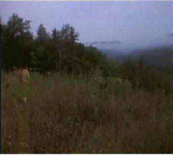
Photo 2: View from Ranger Lake Road lookout point north into the Searchmont South Forest Conservation Reserve. (Photo taken by M. Hall, OMNR; 21 August 2002)
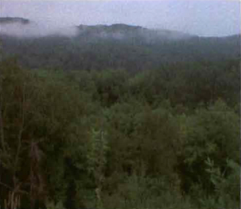
Photo 3: View from Ranger Lake Road lookout point north into the Searchmont South Forest Conservation Reserve. (Photo taken by M. Hall, OMNR; 21 August 2002)
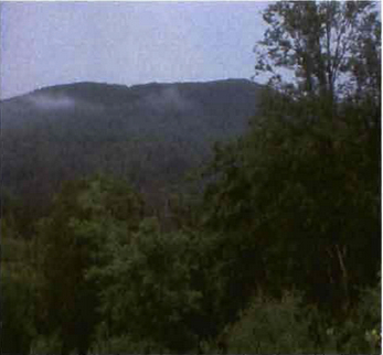
Photo 4: View from Ranger Lake Road lookout point north-northeast into the Searchmont South Forest Conservation Reserve. (Photo taken by M. Hall, OMNR; 21 August 2002)
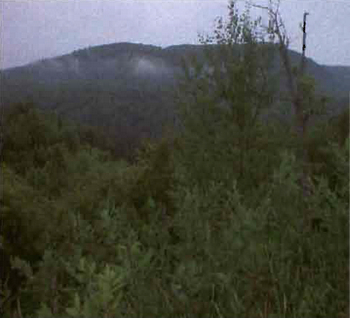
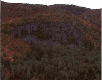
Photo 5: South-facing ridge situated in Searchmont Forest South Conservation Reserve. Photo taken by N. Nathwani during aerial reconnaissance survey OMNR; 26 September 2001
Appendices
Appendix A: SCI Test of Compatibility
Test of Compatibility
-
Conformity to SCI/RMP - SCI describes values for which an area has been set aside and the range of appropriate uses that will be permitted in the area. SCI may also speak to the acceptability of other 'new' uses currently not occurring in the area.
The first 'test' is: "do proposed new land uses and/or commercial activities conform to the direction of the SCI/RMP for the conservation reserve? Would the new use(s) depart from the spirit of appropriate indicator land uses in the SCI/RMP?"
-
Screening Process - proposed uses for the area must be assessed before they are approved. To establish a minimum standard, Northeast Region (NER) recommends that the Screening Process identified in Section 4.2 of A Class EA for Provincial Parks and Conservation Reserves Phase IIb: Draft Class EA (subject to approval by MOE) be used to screen projects and options.
-
Impact Assessment - the Test of Compatibility from the Conservation Reserve Policy (PL 3.03.05) identifies the classes of values and main concepts that need to be considered in determining the impacts of uses on a specific Conservation Reserve. These include:
- Natural heritage
- Cultural
- Research activities
- Current uses
- Area administration
- Accommodating the use outside the conservation reserve
- Socio-economics
- Area accessibility
The class EA (Table 4.1) presents similar values and concepts under the following considerations:
- Natural environment
- Land use, resource management
- Social, cultural and economic
- Aboriginal
The above considerations and classes of values are meant to assist planning staff in answering the following questions for any potential use:
- Will the new use impact any values within the Conservation Reserve?
- If so how?
- To what degree?
- Is it tolerable?
Appendix B: Summary of Permitted Uses
Crown land use atlas – Policy report
C289
Searchmont South Forest
Updated: September 25, 2002
Identification:
ID: C289
Area name: Searchmont South Forest
Area (ha): 626
Designation: Conservation Reserve (Ontario’s Living Legacy)
District(s): Sault Ste. Marie
Description:
This conservation reserve, in Site District 4E-2 protects a rugged bedrock landscape dominated by poplar forests.
Searchmont South Forest was regulated as a conservation reserve on April 6, 2001.
Land use intent:
Management of this area is also governed by the general policies contained in the Land Use Strategy (1999).
Management direction:
Those uses and management activities not listed in the following table are governed by existing conservation reserve policy. Over time the management direction will be elaborated in a Statement of Conservation Interest of Resource Management Plan. Any new uses and commercial activities associated with conservation reserves will be considered on a case by case basis, and they must pass a test of compatibility to be acceptable. Compatibility is normally determined through a planning process.
Commercial activities
| Activity | Permitted | Guidelines |
|---|---|---|
| Aggregate Extraction | No | |
| Bait Fishing - Existing: | Yes | Existing use permitted to continue, unless there are significant demonstrated conflicts. |
| Bait Fishing New: | Maybe | New operations can be considered, subject to the "test of compatibility" |
| Commercial Fishing - Existing: | Yes | Existing use permitted to continue, unless there are significant demonstrated conflicts. |
| Commercial Fishing - New: | Maybe | New operations can be considered, subject to the "test of compatibility". |
| Commercial Fur Harvesting - Existing: | Yes | Existing use permitted to continue, unless there are significant demonstrated conflicts. Existing trap cabins can continue; new cabins are not permitted. |
| Commercial Fur Harvesting - New: | Maybe | New operations can be considered, subject to the "test of compatibility". |
| Commercial Hydro Development | No | |
| Commercial Timber Harvest | No | |
| Commercial Tourism - Existing: | Yes | Existing authorized facilities can continue, unless there are significant demonstrated conflicts. |
| Commercial Tourism - New: | Maybe | New tourism facilities can be considered during the planning for an individual reserve. |
| Bear Hunting by Non residents (guided) - Existing: | Yes | Existing authorized operations permitted to continue. |
| Bear Hunting by Non residents (guided) - New: | No | New operations not permitted. |
| Outfitting Services - Existing: | Yes | Existing authorized operations permitted to continue. |
| Outfitting Services - New: | Maybe | New operations can be considered during the planning for an individual reserve. |
| Outpost Camps - Existing: | Yes | Existing authorized facilities permitted to continue. |
| Outpost Camps - New: | Maybe | New facilities can be considered during the planning for an individual reserve. |
| Resorts/lodges - Existing: | Yes | Existing authorized facilities permitted to continue. |
| Resorts/lodges - New: | Maybe | New facilities can be considered during the planning for an individual reserve. |
| Boat Caches (Managed) | ||
| Energy Transmission and Communications Corridors - Existing: | Yes | These facilities should avoid conservation reserve lands wherever possible. |
| Energy Transmission and Communications Corridors New: | No | |
| Food Harvesting (Commercial) - Existing: | Maybe | |
| Food Harvesting (Commercial) - New: | Maybe | |
| Mineral Exploration and Development | No | |
| Peat Extraction | No | |
| Wild Rice Harvesting - Existing: | Yes | |
| Wild Rice Harvesting - New: | Maybe |
Land and resource management activities
| Activity | Permitted | Guidelines |
|---|---|---|
| Crown Land Disposition Private Use: | Maybe | Sale of lands is not permitted, except for minor dispositions in support of existing uses (e.g. reconstruction of a septic system). Renewals of existing leases and land use permits are permitted. Requests for transfer of tenure will be considered in the context of the Statement of Conservation Interest or Resource Management Plan. |
| Crown Land Disposition Commercial Use: | Maybe | New leases or land use permits permitted for approved activities. Tourism facilities can apply to upgrade tenure from LUP to lease. |
| Fire Suppression | Yes | Fire suppression policies are similar to adjacent Crown lands, unless alternative fire policies have been developed through a planning process. |
| Fish Habitat Management | Maybe | |
| Fish Stocking | Maybe | Conservation Reserves policy indicates that "featured species management" may be permitted. |
| Inventory/disease Suppression | Maybe | |
| Inventory/Monitoring | Yes | |
| Prescribed Burning: | Maybe | |
| Roads (Resource Access) - Existing: | Yes | Existing roads can continue to be used. Continued use will include maintenance and may include future upgrading. |
| Roads (Resource Access) New: | Maybe | New roads for resource extraction will not be permitted, with the exception of necessary access to existing forest reserves for mineral exploration and development. |
| Vegetation Management | Maybe | Conservation Reserves policy indicates that Featured Species Management and Natural Systems Management may be permitted. Vegetation management can be considered in a planning process. |
| Wildlife Population Management | Maybe |
Science, education and heritage appreciation
| Activity | Permitted | Guidelines |
|---|---|---|
| Collecting | No | |
| Historical Appreciation | Yes | |
| Nature Appreciation | Yes | |
| Photography and Painting | Yes | |
| Research | Yes | |
| Wildlife Viewing | Yes |
Recreation activities and facilities
| Activity | Permitted | Guidelines |
|---|---|---|
| All-terrain vehicle use - On Trails: | Yes | Existing use permitted to continue where it does not adversely affect the values being protected. ATV use off trails is not permitted except for direct retrieval of game. |
| All-terrain vehicle use - Off Trails: | No | |
| Campgrounds | Maybe | |
| Food Gathering | Yes | |
| Horseback Riding (trail) | Yes | Existing use on trails permitted. |
| Hunting | Yes | |
| Mountain Bike Use | Yes | Existing use on trails permitted. |
| Motor Boat Use Commercial: | Yes | |
| Motor Boat Use Private: | Yes | |
| Non-motorized Recreation Travel | Yes | |
| Private Recreation Camps (Hunt Camps) - Existing: | Yes | Existing camps permitted to continue, and may be eligible for enhanced tenure, but not purchase of land. |
| Private Recreation Camps (Hunt Camps) New: | No | |
| Rock Climbing: | Maybe | |
| Snowmobiling On Trails: | Yes | Existing use permitted to continue where it does not adversely affect the values being protected. |
| Snowmobiling Off Trails: | Maybe | Snowmobile use off trails is not permitted, except that snowmobiles may be used for direct retrieval of game. |
| Sport Fishing | Yes | |
| Trail Development - Existing: | Maybe | Development of trails for a variety of activities (e.g. hiking, cross-country skiing, cycling, horseback riding, snowmobiling) can be considered as part of planning for an Individual reserve. |
| Trail Development New: |
Note: The policies outlined in this table do not supersede any Aboriginal or treaty rights that may exist, or other legal obligations.
Management of this conservation reserve is carried out within the context of Conservation Reserve policy as amended by the policies for new conservation reserves outlined in the Ontario’s Living Legacy Land Use Strategy.
Source of direction:
Ontario’s Living Legacy Land Use Strategy (1999)
Conservation Reserves Policy (1997)
Sault Ste. Marie District Land Use Guidelines (1983)
Explanation of edits:
Appendix C: Public Consultation Handouts
September 1, 2000
To: Ontario Living Legacy stakeholders
Dear Sir/Madam:
On July 16, 1999, the Ontario Government released the Ontario’s Living Legacy Land Use Strategy, a broad land use approach to the planning and management of much of the Crown lands in central and parts of northern Ontario. A major part of the Ontario’s Living Legacy Land Use Strategy was a government commitment to the biggest expansion of provincial parks and conservation reserves in Ontario’s history. Ontario intends to add 378 new areas to its protected areas system. Ontario’s Living Legacy is a momentous achievement that will be recognized around the world as a significant contribution to sustaining our natural environment. A copy of the Land Use Strategy is available from our office upon request.
In accordance with the recommendations in the Land Use Strategy, the Ministry of Natural Resources is now implementing the process of establishing these 378 new protected areas. The first step in this process is for the Ministry to consult on the boundaries of these areas. In November 1999, MNR held boundary consultations on 64 sites across the OLL Planning Area. Eight of these sites were within Sault Ste. Marie District. At this time, Sault Ste. Marie District has prepared 19 more sites for boundary refinement consultation. Adjacent Districts are consulting an additional two sites, which are also partially contained within Sault Ste. Marie District, on. In future years, the remaining recommended protected areas from the Land Use Strategy will be put forward for similar consultations.
As stated in the Land Use Strategy, the boundary refinement process will consider local ecological information and will attempt to establish regulated boundaries along features that can be identified on the ground. The boundary refinement process may result in modest increases or decreases in the sizes of the protected areas. Any existing commitments for the areas, which were considered during the land use planning process, will be considered in defining the final boundary.
Following is a list of the 21 sites in SSM District scheduled for boundary consultation this year. These sites include both provincial parks and conservation reserves. The Land Use Strategy established the Ministry’s intent to add these Crown lands to Ontario’s protected areas system, following the extensive public consultation associated with Ontario’s Living Legacy and the Lands for Life land use planning initiatives between 1997 and 1999. The Ministry is inviting public comment on the proposed boundaries of these protected areas prior to their finalization and ultimate regulation under the Provincial Parks Act or the Public Lands Act.
C227 - Glen Crombie Conservation Reserve
P238 - Mississagi River Provincial Park Additions
C243 - Wagong Lake Forest Conservation Reserve
C244 - Rawhide Lake Conservation Reserve
C246 - Echo River Hardwoods Conservation Reserve
C247 - Byrnes Lake White Birch Conservation Reserve
P253 - Goulais River Provincial Park
C256 - Basswood Lake Hemlock Conservation Reserve
C258 - Thessalon River Delta I Rock Lake Red Oak Conservation Reserve
C260 - Rose Lake Dune Peatland Complex Conservation Reserve
C262 - Stuart Lake Wetland Conservation Reserve
P273 - Algoma Headwaters Provincial Park
P274 - Wenebegon River Provincial Park
P277 - Aubinadong - Nushatogaini Rivers Provincial Park
P278 - Pancake Bay Provincial Park Additions
P282 - Batchawana River Provincial Park
P285 - Sandy Islands Provincial Nature Reserve
C289 - Searchmont South Forest Conservation Reserve
C291 - Goulais River Beach Ridges Conservation Reserve
P292 - Lake Superior Provincial Park Additions
C307 - lie Parisienne Conservation Reserve
Your name and address have been included within a Ministry mailing list of persons potentially interested in these boundary consultations. The mailing list includes a range of individuals and groups, such as nearby landowners, resource users, persons with other rights or tenure (e.g. Land Use Permits, Mining Act rights), municipalities, and others who may have an interest in the area. Accompanying this letter, you will find background information (factsheets, maps) for the site(s) we have determined to be of interest to you. More detailed maps and information about the proposed boundaries for all 21 sites are available from this office, or from the Blind River Area Office, 62 Queen Ave., Blind River.
In the future and subject to the intended regulation of these areas as provincial parks and conservation reserves, Ontario Parks and the Ministry of Natural Resources will undertake a management planning process to determine the long-term management of these protected areas. Depending upon the complexity of issues related to the provincial parks, management planning may take the form of a simple Interim Management Statement or a more detailed Park Management Plan. In the case of planning for conservation reserves, a simple Statement of Conservation Interest or a more detailed Resource Management Plan will result. Please let us know if you would like to be notified when planning begins.
Planning, management and permitted uses within these provincial parks and conservation reserves would be consistent with the commitments of the Ontario’s Living Legacy Land Use Strategy.
The Ministry is collecting comments and information regarding these proposed provincial park and conservation reserve boundary reviews under the authority of the Provincial Parks Act and the Public Lands Act respectively. These comments will assist the Ministry in making decisions and determining further public consultation needs. Comments and opinions will be kept on file and may be included in study documentation that is made available for public review. Under the Freedom of Information and Protection of Privacy Act (1987), personal information will remain confidential unless prior consent is obtained. However, the Ministry may use this information as public input on other resource management surveys or projects. For further information regarding this Act, please contact Paul Glassford, A/Information Management Supervisor, Ministry of Natural Resources, Sault Ste. Marie District 705-949-1231.
If you would like to discuss the proposed boundaries and the protection of these areas under the Provincial Parks Act and/or the Public Lands Act, please contact Erin Nixon, District Planner, Ministry of Natural Resources, 64 Church Street, Sault Ste. Marie, Ontario, P6A 3H3; telephone 705-949-1231 ext. 247, fax (705) 949-6450, by October 6, 2000. Further information on Ontario’s Living Legacy is available in our office or by visiting the Ministry’s internet website at www.mnr.gov.on.ca/MNR/oll/ [link is no longer active].
Thank you for your interest.
Yours sincerely,
Dick Hagman
A/District Manager
Sault Ste. Marie District
DH/sw
Attachments:
Provincial Park and/or Conservation Reserve Factsheet(s)
Proposed Site Boundary Map(s)
Key Map
Permitted Uses Table(s) for Provincial Parks and/or Conservation Reserves
On peut obtenir la version française de la présente lettre en s'adressant au bureau du MRN le plus proche, à l'adresse ou au numéro de téléphone ci-dessous.
Searchmont South Forest Conservation Reserve (C289) Fact sheet
September, 2000
Background
On July 16, 1999, the Ontario Government released the Ontario’s Living Legacy Land Use Strategy to guide the planning and management of Crown lands in central and parts of northern Ontario. A major part of the Ontario’s Living Legacy Land Use Strategy was a government intent to establish 378 new protected areas. This commitment marks the biggest expansion of provincial parks and conservation reserves in Ontario’s history.
The proposed Searchmont South Forest Conservation Reserve is part of this significant expansion of Ontario’s protected areas system. Following public and First Nations consultation in late 2000 and early 2001 on refining the boundary on this protected area, Ontario Regulation 805/94 of the Public Lands Act, was amended on April 6, 2001 by Ontario Regulation 86/01, to formally establish this conservation reserve.
Size and location
The Searchmont South Forest Conservation Reserve comprises 580 ha of mainly forested land. It is located approximately 40 km northwest of Sault Ste. Marie, in Hodgins township. The conservation reserve is located south of the community of Searchmont. It is situated east of the Algoma Central Railway, on the north side of hwy 556 near its junction with hwy 532.
Area highlights
The Searchmont South Forest Conservation Reserve is located within ecological site district 4E-2. This site district extends approximately 60-90 km inland from the eastern shore of Lake Superior, and is characterized by rugged topography and elevations exceeding 450 m. The topography is the result of numerous geological structures such as faults, joints, and diabase dikes that dissect the area. The bedrock uplands have a thin layer of sandy soil on slopes and thicker soils in the valleys. Exposed bedrock is common, and dates back billions of years to the Precambrian and Cambrian periods.
This conservation reserve protects a rugged bedrock landscape with poplar dominated forests. Red pine, white birch, jack pine, white spruce, and black spruce are also present within the site. Bird surveys within this site have identified a full complement of songbird species including the wood thrush, occurring at the northern extent of its range. Sandhill cranes have also been recorded in the area. Braun’s holly fern, a provincially significant plant species, was recorded on the site.
The Searchmont South Forest has high recreational values. Abutting private lands include a resort that offers alpine and nordic ski opportunities as well as hiking and cycling trails. Trails for these activities have also been established through portions of this conservation reserve. The site is In close proximity to populated areas, and it is easily accessible via provincial highway.
Land use intent
Conservation reserves are areas of Crown land set aside by regulation under the Public Lands Act.
Conservation reserves complement provincial parks in protecting representative natural areas and special landscapes. Most recreational (e.g. hiking, skiing, tourism related uses, nature appreciation) and non-industrial (e.g. fur harvesting, commercial fishing and bait harvesting) activities that have traditionally been enjoyed in the area will continue, provided that these uses do not impact on the natural features needing protection. Hunting and fishing are also permitted within all new conservation reserves recommended through Ontario’s Living Legacy.
Commercial timber harvesting, mining, aggregate extraction and commercial hydroelectric development are prohibited in conservation reserves. Careful mineral exploration may occur in specific new conservation reserves proposed through Ontario’s Living Legacy, in areas that have provincially significant mineral potential. If a portion of a new conservation reserve is to be developed for a mine, it would be removed from the reserve, and appropriate replacement lands would be placed in regulation. Please refer to Table 4 from the Land Use Strategy for a detailed summary of permitted uses in conservation reserves.
Next steps
The Land Use Strategy established the Ministry’s intent to add these Crown lands to Ontario’s protected areas system, following the extensive public consultation associated with the Ontario’s Living Legacy and Lands for Life land use planning initiatives between 1997 and 1999. Prior to the finalization of the boundary of this conservation reserve proposed for regulation under the Public Lands Act, the Ministry is inviting public comment on the proposed boundary from all potentially affected stakeholders and First Nations from September 1 to September 30, 2000.
In the interim, the area has been withdrawn and protected from resource extraction activities such as timber harvesting, hydroelectric development, aggregate extraction and new mineral exploration.
In the future and subject to the intended regulation of the area as a conservation reserve, the Ministry of Natural Resources will prepare a long term management plan for this area. Depending upon the complexity of issues within this conservation reserve, management planning may take the form of a simple Statement of Conservation Interest or a more detailed Resource Management Plan. Please let us know if you would like to be notified when planning begins.
Planning, management and the uses permitted within this conservation reserve will be consistent with the commitments of the Ontario’s Living Legacy Land Use Strategy.
For more information
For further information on the proposed Searchmont South Forest Conservation Reserve, please contact Erin Nixon, District Planner, Ministry of Natural Resources, Sault Ste. Marie District (705-949-1231 ext. 247). You may also visit the Ministry’s internet website at www.mnr.gov.on.ca/MNR/oll/ [link is no longer active] for information about Ontario’s Living Legacy.
64 Church Street
Sault Ste. Marie, ON P6A 3H3
August 22, 2001
Regulation of Ontario’s Living Legacy Protected Areas in Sault Ste. Marie District
In July 1999, the Ontario Government released the Ontario’s Living Legacy Land Use Strategy, a broad land use approach to the planning and management of Crown lands in central and parts of northern Ontario. A large component of the Ontario’s Living Legacy Land Use Strategy was a government commitment to add 378 new provincial parks and conservation reserves to Ontario’s protected areas system.
In November 1999 and again in September 2000, we provided you with the opportunity to comment on the proposed boundaries for the park and the conservation reserves in Sault Ste. Marie District. I am pleased to inform you that, as of January 2001, the park and fifteen of these conservation reserves have been regulated. The new park and conservation reserves in the District are:
P285 Sandy Islands Provincial Nature Reserve
C243 Wagong Lake Forest Conservation Reserve
C244 Rawhide Lake Conservation Reserve
C245 Jollineau Conservation Reserve Conservation Reserve
C246 Echo River Hardwoods Conservation Reserve
C258 Thessa/on River Delta/Rock Lake Red Oak Conservation Reserve
C260 Rose Lake Dune Peat/and Complex Conservation Reserve
C262 Stuart Lake Wetland Conservation Reserve
C263 Garden Lake Forest Conservation Reserve
C281Tilley Creek West Conservation Reserve
C284 Wabos North Conservation Reserve
C286 Wabos South Conservation Reserve
C289 Searchmont South Forest Conservation Reserve
C294 O'Connor Conservation Reserve
C298 Harmony Forest Conservation Reserve
C307 lie Parisienne Conservation Reserve
Regulation means the park and conservation reserves are now legally mapped and recognized as protected areas of crown land under the jurisdiction of the provincial government. As such, these areas will be protected from industrial activities, including commercial forestry, hydroelectric development, mining, and aggregate and peat extraction. Traditional recreational and resource uses such as hunting, fishing, hiking, canoeing, boating, and fur trapping, will generally be permitted to continue within the conservation reserves. In nature reserve class provincial parks (e.g. P285, Sandy Islands), hunting and fur trapping are not permitted; other traditional recreational uses (fishing, hiking, canoeing, boating) may continue.
Ontario Parks staff is responsible for the planning and management of Sandy Islands Provincial Nature Reserve and they will prepare an Interim Management Statement.
Footnotes
- footnote[1] Back to paragraph This Test of Compatibly is taken from both Procedural Guidelines B-Land Uses - Test of Compatibility PL 3.03.05 and from the Planning Process for Conservation Reserve Statement of Conservation Interest and Resource Management Plan Northeast Region Guidelines Version 2.1 September 17, 2001.