Seguin River Conifer and Fens Conservation Reserve Management Statement
This document provides policy direction for the protection, development and management of the Seguin River Conifer and Fens Conservation Reserve and its resources.
(C1612)
Statement of Conservation Interest
January 2004
Cochrane District
Ontario Ministry of Natural Resource
Approval statement
I am pleased to approve this Statement of Conservation Interest (SCI) for the Seguin River Conifer and Fens Conservation Reserve.
As part of the Ontario’s Living Legacy planning initiative to establish additional parks and protected areas representative of the ecological diversity within Ontario’s natural regions, the Seguin River Conifer and Fens Conservation Reserve selected for its unusual representation of landscape patterns and diversity of vegetation communities. The reserve is located in Seguin and Raven Townships, approximately 53 km northeast of the municipality of Cochrane.
Direction for establishing, planning and managing conservation reserves is provided by regulation under the Public Lands Act and through the Ontario’s Living Legacy Land Use Strategy. Specific direction for the management of this conservation reserve is provided through this SCI, which defines the area to which the plan applies, describes the purpose for which the conservation reserve has been proposed and outlines the management intent for the protected area. As the minimum level of management direction required, this basic SCI will provide guidance for the management of the Seguin River Conifer and Fens Conservation Reserve and the basis for the ongoing monitoring of activities. Additional planning direction is not anticipated but should significant development be considered or complex issues arise, which require additional information, more defined management direction or special protection measures, a more detailed Resource Management Plan (RMP) will be prepared for the conservation reserve with full public consultation.
During the Lands for Life planning process, the public was widely consulted and provided valuable input into the Ontario’s Living Legacy Land Use Strategy (1999). Comments received during that time, and during the consultation exercise for the formal regulation of the boundaries of the Seguin River Conifer and Fens Conservation Reserve, were generally supportive of the protection of this area and were considered in the development of this document.
This SCI was prepared with input from program specialists at the Cochrane District MNR office. As well, a draft version of the document was provided for review to the MNR Regional planning unit and specialists with Ontario Parks, Fire Management and the Ministry of Northern Development and Mines. Limited public and aboriginal consultation on the draft version of the document was conducted with First Nations and members of the public who had expressed interest in participating in the planning exercise for this conservation reserve. Comments received from these reviews were also considered in the development of the SCI.
The conservation reserve will be managed under the jurisdiction of the Iroquois Falls Area Supervisor of the Ontario Ministry of Natural Resources, Cochrane District.
Submitted by:
Mary Kirkbride - Plan Compiler
with Colin Lake
Original signed by Ed Tear
District Manager Recommendation
Date: March 15, 2005
Approved by:
Original signed by Rob Galloway
Regional Director
Northeast Region
Date: April 5, 2005
1.0 Introduction
Ontario’s network of natural heritage areas has been established to protect and conserve areas representative of the diversity of the natural regions of the province, including species, habitats, features, and ecological systems which comprise that natural diversity. Protection of these sensitive areas ensures that representative sites within the larger landscape are permanently retained in their natural state.
Conservation Reserves (CR) were established in Ontario as one means of providing protection for these areas on public lands, while permitting many traditional uses to continue. As the result of an extensive planning process conducted in Ontario between 1997 and 1999, the Ontario’s Living Legacy (OLL) Land Use Strategy (LUS) (OMNR, 1999) as well as the Crown land use Policy Atlas set the direction for the establishment and management of additional parks and protected areas. Objectives of this strategy include protection of natural and cultural heritage values while providing opportunities for outdoor recreation, heritage appreciation and tourism (OMNR, 1999).
Ontario’s Living Legacy (OLL) Land Use Strategy (LUS) (OMNR, 1999) sets the direction for the establishment and management of new parks and protected areas. The objectives of this strategy include protection of natural and cultural heritage values while providing opportunities for outdoor recreation, heritage appreciation and tourism (OMNR, 1999).
Protected areas designated within the OLL LUS have been selected based on their representation of the spectrum of the province’s ecosystems and natural features including both biological and geological features, while minimizing impacts on other land uses. Representation was described using landform and vegetation combinations based on Hill’s eco district concept (1959).
As part of the strategy, the Seguin River Conifer and Fens Conservation Reserve was selected for its unusual representation of landscape patterns and diversity of vegetation communities within the Smokey Falls Eco-District 3E-1 (Crins and Uhlig, 2000). The reserve is comprised of 6833 ha of Crown land located in Raven and Seguin Townships, approximately 53 kilometers northeast of the municipality of Cochrane. The site will be regulated under the Public Lands Act.
The level of planning required for a conservation reserve is based on a number of criteria including the complexity and scope of issues, relative size and remoteness of the site, and the number and variety of current permitted uses. As no significant issues or conflicts were identified for the Seguin River Conifer and Fens Conservation Reserve beyond those addressed during the preparation of the Ontario’s Living Legacy Land Use Strategy, the minimum level of management direction required, in the form of this Statement of Conservation Interest (SCI), has been developed. Comments received from stakeholders and from the public during the consultation exercise on the formal regulation of the reserve boundaries were generally supportive of the protection of this area and were considered in the finalization of this document.
The management intent for the Seguin River Conifer and Fens Conservation Reserve is to protect the natural and cultural heritage values within the reserve while permitting compatible land use activities. To achieve this, this SCI will identify and describe the natural heritage values within the reserve. It will also provide direction for the management of current and future activities while protecting those values. This direction will comply with land use intent as stated by the OLL Land Use Strategy (OMNR, 1999).
To ensure that protection objectives are being fully met within the conservation reserve, activities on the surrounding landscape should also consider the site’s objectives and heritage values.
In addition, it is the intent of this management document to promote public awareness toward responsible stewardship of protected areas and their surrounding lands in Ontario. With management partners such as Ontario Parks, industry, local governments, etc., the Ministry will be able to pursue and advance sound environmental, economic and social strategies and policies related to the protection of this conservation reserve.
The management of the Seguin River Conifer and Fens Conservation Reserve will be administered by the Iroquois Falls Area Supervisor of the Cochrane District Ministry of Natural Resources.
2.0 Goals and objectives
2.1 Goal of the Statement of Conservation Interest
The goal of Conservation Reserves, as stated in Policy PL 3.03.05 (MNR, 1997), is to protect natural heritage values on public lands while permitting compatible land use activities. This Statement of Conservation Interest is intended to guide the management decisions that will ensure that the Seguin River Conifer and Fens Conservation Reserve achieves its goal as a conservation reserve, through the following short and long-term objectives.
2.2 Objectives of the SCI
2.2.1 Short-term objectives
The short-term objectives are to:
- identify the State of the Resource with respect to natural heritage values and the current land use activities within the Seguin River Conifer and Fens Conservation Reserve
- protect the natural values of the reserve via specific guidelines, strategies and prescriptions
- Meet the legislated planning requirements for the development of a planning document within three years of the regulation of the site
2.2.2 Long-term objectives
The long-term objectives will be to:
- establish representative targets (e.g. future forest conditions) and validate the site as a potential scientific benchmark
- identify research/client services and marketing strategies
- provide direction for the evaluation of future new uses and economic activities
3.0 Management planning
3.1 Planning context
3.1.1 Planning area
The planning area consists of the area within the regulated boundary of the Seguin River Conifer and Fens Conservation Reserve, as described in Section 4.1.2.2 Administrative Description. No forest reserves are associated with this planning area. The site has been removed from the landbase of the Iroquois Falls Forest Sustainable Forestry Licence (SFL).
3.1.2 Management planning context
The Seguin River Conifer and Fens Conservation Reserve was identified for protection under the Ontario’s Living Legacy Land Use Strategy (1999) and will be regulated under the Public Lands Act, amending Ontario Regulation 805/94 (Conservation Reserves).
The Seguin River Conifer and Fens Conservation Reserve will be managed as a conservation reserve in accordance with the Ontario’s Living Legacy Land Use Strategy (OMNR, 1999). Where the OLL LUS is silent, management of the reserve will take its direction from existing Conservation Reserve policy. This Statement of Conservation Interest will further define the land use and resource management activities which may occur within the reserve.
By regulation, activities prohibited within this reserve include mining, commercial forest harvest, hydroelectric power development, extraction of aggregate and peat or any other industrial use. The site has been removed from the landbase of the Iroquois Falls Forest forest management unit. However, to ensure that the values within this planning area are protected, the surrounding lands and associated land use activities will also require consideration within a larger planning context including the forest management plan for the Iroquois Falls Forest, as well as any future resource management plans.
No mining tenure exists within the reserve; mining and surface rights have been withdrawn from staking within the reserve boundaries.
Based on the representation of the site and its natural heritage values, and direction from the OLL and Conservation Reserve policy, the SCI will identify permitted uses within the reserve and provide guidance for the resolution of conflicts between uses. Generally low impact recreational and non-commercial uses may be permitted. Some commercial uses and resource management activities may also be acceptable within the conservation reserve, provided they are compatible with the values of the reserve. New uses, and activities associated with them, may be considered on a case-by-case basis, and undergo environmental screening to determine the compatibility of the use/activity with natural heritage values within the site. Proposals pertaining to cultural resources may be screened under Section 3, Conserving a Future for our Past: Archaeology, Land Use Planning and Development in Ontario (MCzCR, 1997). The SCI will only address current and potential permitted uses brought forward during the planning process. Any activity or disposition of a right to a Crown resource, allowed as a permitted use and passing the required environmental and/or cultural tests of compatibility will also be subject to screening under the Class Environmental Assessment for MNR Resource Stewardship and Facility Development Projects, or, pending its approval, the Class EA for Provincial Parks and Conservation Reserves.
3.2 Planning process
The level of management planning required to fulfill the protection targets of a conservation reserve is based, primarily, on the scope and complexity of its planning issues, as described in the Procedural Guideline A for SCI and RMP (MNR PL 3.03.05, 1997) and further clarified for conservation reserves located in the OMNR Northeast Region (Planning Process for Conservation Reserves Statement of Conservation Interest (SCI) and Resource Management Plans (RMP), Northeast Region Guidelines, V. 2.1, Sept, 2001).
No significant issues or conflicts were identified for the Seguin River Conifer and Fens Conservation Reserve beyond those brought forward during the Lands for Life planning process or subsequent development of the Ontario’s Living Legacy Land Use Strategy. Therefore, this Statement of Conservation, developed within the required 3 years of the regulation date of the reserve, will provide the direction for basic stewardship of the site.
An opportunity to review the proposed boundaries for regulation of the reserve, along with the other proposed parks, park additions and conservation reserves within the OMNR Cochrane Administrative District was provided through newspaper advertising for the period of September 6 to October 6, 2000. For the boundary consultation exercise, information packages were also mailed directly to stakeholders, including individuals and organizations, which were known to be interested in or directly affected by the regulation of the areas. In addition, an information package was provided to the Taykwa Tagamou Nation and the Wahgoshig First Nation. All comments received were considered in the development of this SCI.
Key District staff was consulted during the development of the SCI. A draft version of this SCI was provided for review to OMNR Regional Planning Unit, and the Fire Management program, as well as Ontario Parks and the Ministry of Northern Development and Mines. A draft version of this SCI was also provided for review to individuals and organizations who had previously expressed an interest in participating in the planning process. As well, a draft version of the SCI was presented to Taykwa Tagamou Nation. All comments received from these reviews were considered in the development of the final document.
Upon approval by the OMNR Northeast Regional Director, the plan will be made available for inspection by the public. Following this consultation, the plan will be implemented.
No notice of this planning process was required to be posted on the Environmental Registry, under the Environmental Bill of Rights, as no new issues were identified in the development of this SCI which would require public consultation substantially different from what was conducted for the development of the OLL LUS.
4.0 Background information
4.1 Location and site description
4.1.1 Location
The Seguin River Conifer and Fens Conservation Reserve is situated approximately 53 kilometers northeast of Cochrane, Ontario, in the townships of Seguin and Raven. Additional locational and administrative information is presented in Table 1.
Table 1: Location and Administrative Details for Seguin River Conifer and Fens Conservation Reserve
| Name | Seguin River Conifer and Fens Conservation Reserve |
|---|---|
| Eco Region – Eco District (Hills) | 3-E, 3-E1 (Hills 1959) |
| OMNR Region/District | Northeast/Cochrane |
| Total Area | 6833 ha |
| UTM Coordinates | 1720554796E, 17205454812N |
| Nearest Town/Municipality | Cochrane |
| Township(s) | Seguin, Raven |
| OBM Numbers | 54545, 55545, 56545 |
| Map Number | 42-H/1 (Mistango Lake), 42-H/8 (Twopeak Lake) |
| Wildlife Management Unit | 27 |
| Forest Management Unit | Iroquois Falls Forest |
| Regulation Date | Pending |
4.1.2 Site description
4.1.2.1 Physical description
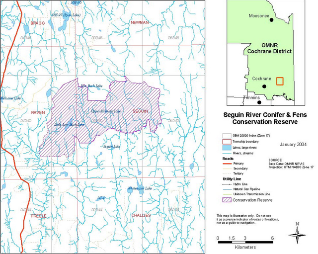
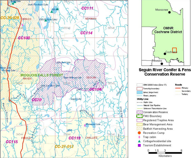
As illustrated in Figure 1, the Seguin River Conifer and Fens Conservation Reserve is located in Seguin and Raven Townships approximately 53 kilometres northeast of the municipality of Cochrane. The conservation reserve consists of 6683 hectares of Crown land, approximately 11 kilometres in length and 6-7 kilometres in width oriented in a east-west direction, narrow through the central part of the site.
The boundary of the reserve is delineated by natural, cultural and vectored boundaries. Most of the west and part of the southwest boundary is formed by tertiary forest access roads; the remaining boundary is formed by a combination of vectors connecting the boundary along sections of the shorelines of creeks and rivers in the area, including tributaries of the Seguin and Low Bush Rivers.
Primary access to the general area of the conservation reserve is provided by secondary forest access road, known locally as the Michel Lake Road, located within 3 kilometres of the site. The western portion of the reserve may be accessed by all-terrain and 4- wheel drive vehicles, using tertiary forest access roads and trails from Michel Lake Road as well as a secondary forest access road northwest of the site.
Figure 1: Location and boundary of the Seguin River Conifer and Fens Conservation Reserve
Enlarge Figure 1: Location and boundary of the Seguin River Conifer and Fens Conservation Reserve
4.1.2.2 Administrative description
The legal boundaries of the Seguin River Conifer and Fens Conservation Reserve will be filed with the Ontario Surveyor General, Ministry of Natural Resources in Peterborough, Ontario. This site is currently waiting to be passed into regulation.
The conservation reserve is located entirely within the Iroquois Falls Forest Management Unit and the current SFL holder is Abitibi-Consolidated Company of Canada.
4.2 History of the site
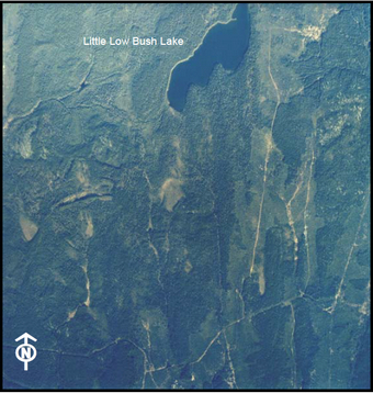
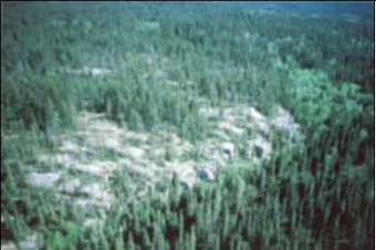
This area was once covered by glacial Lake Ojibway, resulting in a relatively flat plain of lacustrine clay and loam (Taylor et al 2000). In more recent times, forest harvest has occurred in the north and west areas of the conservation reserve (prior to 1986 according to aerial photography interpretation). More recently, harvesting has occurred east and southeast of Little Lowbush Lake (see figure 2). Other disturbances include a fire in 1955 in the north-central region of the conservation reserve.
Figure 2: Harvested areas in the southeast portion of Seguin River Conifer and Fens Conservation Reserve
4.3 Inventories
Table 2 illustrates the inventories/surveys completed for the Seguin River Conifer and Fens Conservation Reserve. Inventory checksheets are attached as appendices.
Table 2: Inventory and Survey Information for Seguin River Conifer and Fens Conservation Reserve
| Type of Inventory | Method | Date | Report |
|---|---|---|---|
| Life Science | Aerial reconnaissance | 2001 | Merchant, B. Burkhardt, B. Silver, M. King, L. Longyear, Sean. 2003 Life Science Checksheet – Step 2 Seguin River Conifer and Fens Conservation Reserve. Unpublished Information. OMNR |
| Recreation | Aerial reconnaissance | 28/09/2001 | Stewart, Robin. 2001Recreation Inventory Checklist for Seguin River Conifer and Fens Conservation Reserve. Unpublished Information. OMNR |
5.0 State of the resource
Representation
Representation is the major principle in achieving the protection targets in Ontario’s system of parks and protected areas. Areas are selected for their representation of natural heritage values within the full spectrum of landscapes, ecosystems, habitats, communities and special features including species and their genetic diversity.
Representation targets for earth sciences are based on the record of earth history in rocks, landforms and geological processes. Targets for life science representation have been developed using landform/vegetation combinations at the Site District level (Hills,1959), and later the Eco-District level (Crins and Uhlig, 2000). Earth and life science inventories conducted for the Seguin River Conifer and Fens Conservation Reserve identify the features and characteristics of its representation.
Located in the Smokey Falls Eco-district 3E-1 (Crins and Uhlig, 2000), the Seguin River Conifer and Fens Conservation Reserve features significantly contrasting landscapes along with a range of vegetation communities.
While the Eco-district is normally characterized by smooth plains of glaciolactustrine clay and loam, over bedrock, this reserve features a gently rolling relief of drumlinized till through the southwest and northwest portions of the site, weakly broken by exposed bedrock outcrops of high relief through the central and eastern areas. The remainder of the site is composed of sandy glaciolacustrine plains of low relief with a portion of old raised beach running north-south, north of Little Low Bush Lake.
During a recent aerial reconnaissance of the reserve (2001), forest communities were observed to be predominantly black spruce and jack pine coniferous with areas of trembling aspen mixed wood occurring on the eastern edge of the site and birch and birch mixedwood sites abundant in the northwest. Jackpine and aspen dominated mixed-wood forests are generally found on mid-slopes and sites of improved drainage, while black spruce is generally associated with stream/creek valleys and lowlands areas, or lower slope positions along with balsam fir and tamarack, particularly along the edges of wetlands and streams. Crests and ridges on shallow till support jack pine-reindeer lichen-blueberry communities. Stocking of the forested areas is generally greater than 70% and age classes, ranging from immature to old, are well distributed through the 60-89 year old forest communities which dominate the reserve.
The site of a forest fire, in the north-central part of the reserve has regenerated to jack pine with extensive areas of white spruce and patches of balsam fir.
A broad range of ecosystems are represented in this reserve. Several forested ecosites have been classified (Taylor et al, 2000). Wetland and aquatic ecosites identified include several types of bogs communities, as well as fens, swamps, and many creeks and small lakes.
The conservation reserve lies primarily within the 4MA and 4ME tertiary watersheds of the Moose River Basin, with a small northern portion in the 4NB tertiary watershed of an unnamed major basin flowing into James Bay.
The reserve is generally higher than the surrounding land and is drained by streams flowing outward into the Seguin River, and Low Bush River systems. Many small creeks, throughout the reserve, as well as the shoreline areas of Little Low Bush Lake, in the south west area of the site provide good aquatic feeding areas.
Figure 3 illustrates various forest cover types found within the Seguin River Conifer and Fens Conservation Reserve.
Fig. 3a Taken at the NE corner looking south. Thicket swamps and shore fens on creek, surrounded by Sb pure and Sb predominant conifer to the left and Sb dominant conifer to the right.
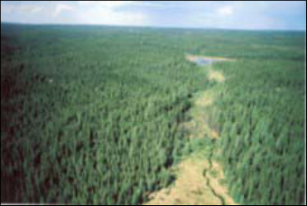
Fig. 3b Po mixed-wood forest community at the SE corner with unnamed creek through it. Surrounded by Sb pure and Pj conifer mixed and Pj dominant conifer.
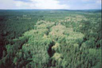
Fig. 3c Seguin River near the SE corner. Thicket swamps along the river. Forest communities include Po mixed-woods, Pj mixed-wood and Pj predominant conifer.
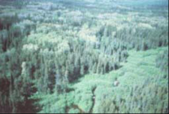
Fig. 3d Bedrock outcrop (SW corner?) surrounded by Pj dominant conifer and Sb predominant conifer forest communities.
(All Photos taken by J.E. Thompson, 1998.)
Figure 3: Examples of forest cover types found in the Sequin River Conifer and Fens Conservation Reserve
Quality of representation:
a) Diversity
Diversity is a measure of the number and range of natural landscape features and vegetation communities. It is also based on the relative richness and evenness of the life science components.
A life science inventory conducted in 2003 rated the diversity of the Seguin River Conifer and Fens Conservation Reserve as high based on the significant variety of landscapes and vegetation communities found within the site. Approximately 23 landform:vegetation combinations were determined using the current provincial landform coverage. Although this combination generally indicates low diversity, the ecosite types are well dispersed,varying in size and type and species richness. As well, the distribution of immature, mature and old growth forest communities throughout the site adds to its diversity.
b) Ecological factors
Wherever possible, conservation reserve boundaries should be designed to capture the greatest diversity of life and earth science features to provide the maximum ecological integrity. A reserve should be ecologically self-contained, bounded by natural features and include adequate area to buffer the core ecosystems from adjacent land use activities (OMNR, 1992). In addition, linkages to undisturbed landscapes contributes to the ecological integrity of a protected area.
The conservation reserve is primarily bounded by natural features such as Seguin River and other creek/stream systems and some cultural features such as harvest roads along the west and southwest edges. Small sections of the boundary are vectored between natural boundary features and are difficult to distinguish.
With a total area of 6833 hectares, the Seguin River Conifer and Fens Conservation Reserve exceeds the standard of 2000 hectares, considered by Ontario Parks (OMNR, 1992) to be the minimum area necessary to protect representative landscapes as well as allow for low intensity recreational activities. However, a significant area of weakly broken bedrock is located in the narrow central area of the reserve, exposing it more immediately to the influence of landuse activities that occur outside the reserve.
Based on pre-1986 aerial photography, harvesting has occurred in areas immediately north and east of the reserve. The outward nature of the drainage systems and the distribution of forest communities throughout the site provides some protection from the effects of land use activities on the surrounding lands. Although the reserve is remote, maintaining a linkage with the surrounding natural landscapes, which remain relatively undisturbed; forest access roads and several trails provide access to the general area and into southern parts of the reserve.
c) Condition
Condition is a measure of the amount of disturbance, man-made or natural, that has occurred within a conservation reserve. The disturbance rating for this conservation reserve is medium, with 10-20% of the site area estimated to have experienced some form of disturbance.
Harvesting occurred (pre-1986) in and around the north and west sides of the conservation reserve. As well, harvesting has occurred east and southeast of Little Low Bush Lake. Trails form the western and part of the southern boundary of the site.
During aerial reconnaissance of the reserve in 2000, the effects of the defoliation of trembling aspen by Forest Tent Caterpillar was observed. As well, regeneration was observed in an area in the north-central part of the site, burned by forest fire in 1955.
Significant evidence of beaver activity was also noted.
d) Special features
Although the Seguin River Conifer and Fens Conservation Reserve was identified as a gap site during the option development phase of the land use strategy, to replace sites or portions of sites with known conflict, the reserve provides a great diversity in landform and vegetation complexes. The variety of the topography is considered to be an unusual representation within the Eco-District 3E-1. The areas of exposed bedrock in the northern portion of the site are also a significant feature of the site.
e) Current land use activities
The Seguin River Conifer and Fens Conservation Reserve is located within the areas of four active traplines. No bear management areas are located within the reserve boundaries; a bear management area, CC-27-13, is located within 350 metres of the western boundary of the reserve. No baitfish harvesting is currently permitted within the reserve boundaries; a baitfish harvest block abuts the northwestern boundary of the reserve. The reserve is also part of the marten core management area 7 of the Iroquois Falls Forest. No permitted structures exist within the reserve; however, two tree-stands, probably used for moose-hunting, were observed during aerial reconnaissance in the northeast portion of the site. Old harvest roads and trails in the area provide access via all-terrain vehicle. Silviculture activities are planned for the area southeast of and outside of the conservation reserve.
Summary
With the range and character of the landscape patterns and the diversity of the vegetation communities found in the Seguin River Conifer and Fens Conservation Reserve the site is a significant representation within this Eco-District.
5.1 Social/economic interest in area
a) Linkage to local communities
There are no communities near the conservation reserve; the nearest municipality is Cochrane, located approximately 53 kilometers to the southwest. Primary access to the area is provided by the Michel Lake Road, a secondary forest access road from Michel Lake Road is located north and west of the site; trails from this access road form the boundary and limited access to the western portion of the reserve. The site provides hunting, trapping and fishing opportunities primarily for the local communities of Cochrane, and Iroquois Falls.
b) Heritage estate contributions
The Seguin River Conifer and Fens Conservation Reserve contributes to the province’s parks and protected areas system through its regulation, representation and the long-term management of its natural heritage values.
The protected area system allows for permanent protection of our history and special features, and it will provide valuable areas as benchmarks to scientists and educators as more and more of Ontario’s land base is developed or altered from its natural state.
Each protected area contributes to this heritage in its own unique way – whether it is a contribution to the preservation of an earth science value, a life science value, a recreational or economic opportunity, or through its cultural/historical significance. The designation of an area as a conservation reserve helps define its role in the system.
The Seguin River Conifer and Fens Conservation Reserve’s distinct contribution is a combination of life science/glacial history preservation. The special feature for this conservation reserve was the high diversity, especially for Eco-District 3E-1 and the good dispersion of forest communities across the site. The numerous streams and creeks flowing throughout the reserve, along with the exposed bedrock outcrops provide significant interpretive value. The relative accessibility of the site and its proximity to local communities provides opportunities for both recreational and investigative activities.
c) Aboriginal groups
The reserve is located within the territory of the James Bay Treaty 9. An area of high archaeological site potential for the Wahgoshig First Nation, identified as part of the Lake Abitibi Model Forest, Cultural Heritage Project (1995), is located in the southwestern portion of the reserve. The reserve encompasses an area which may include a traditional travelway connecting Seguin Lake, lying south of the reserve, to the Lowbush River system. The conservation reserve is also in the area of interest of Taykwa Tagamou Nation. There are no First Nations land claims in the area.
d) Mining interests
The conservation reserve has no mining tenure within it. Mining and surface rights have been withdrawn form staking within the conservation reserve boundaries under the Mining Act (RSO 1990, Chapter M.14).
e) Forest and fire management history
The disturbance rating for this conservation reserve was determined to be medium, due, in part, to harvesting, before1986, in and around the north and west sides of the conservation reserve (based on aerial photography). Harvesting has also taken place east and southeast of Little Low Bush Lake. A forest fire occurred in 1955, resulting in regeneration of jack pine, with areas of white spruce and balsam fir.
5.2 Natural Heritage Stewardship
The Seguin River Conifer and Fens Conservation Reserve is unique relative to the adjoining areas of its ecodistrict: the topography varies from gently undulating to strongly broken, with exposed bedrock or shallow sandy veneers near the hilltops and ridges, and fine sand and clay in the valleys between. This contrast in landscapes gives the reserve high representative value. The reserve is located within the area encompassed by the Lake Abitibi Model Forest, which, through partnerships, undertakes research projects to investigate sustainable forest management. Projects may include natural and cultural heritage assessment, and technical evaluation.
The conservation reserve also contributes to the variety of recreational opportunities that can be found in the parks and protected areas system.
5.3 Fisheries and wildlife
Wildlife values for this conservation reserve include four trapline areas: CC100, CC104, CC114, and CC70. There are no baitfish blocks or bear management areas (BMA's) within the reserve, however, both occur just beyond the western boundary.
Data collected from radio collaring (1998-2001) show limited use of the area around the Seguin River Conifer and Fens Conservation Reserve, by Woodland Caribou. Several points (low usage) were collected west of the conservation reserve, and abundant usage was determined for areas north and northwest of the conservation reserve boundary.
The Woodland Caribou (Rangifer tarandus caribou) is provincially classified as a species at risk (SAR) and is sensitive to disturbance. In May 2002, COSEWIC (Committee on the Status of Endangered Wildlife in Canada) confirmed a "threatened" status for the Boreal Population of Woodland Caribou. Woodland caribou populations are tracked by the Natural Heritage Information (NHIC) sector of the OMNR.
Most of the reserve area has been identified as part of the marten core management area 7 of the Iroquois Falls Forest forest management unit. There are no known cold water bodies within the reserve; six water bodies have been confirmed as cool.
No other fisheries data has been collected for the waterbodies located within the conservation reserve boundary, including Little Low Bush Lake and Upper Mikwam Lakes.
5.4 Cultural Heritage Stewardship
There are no known cultural heritage values or recorded archeological values within the site.
5.5 Land use/current or past development
The site is comprised entirely of Crown land; no development has taken place within the reserve. During an aerial reconnaissance in 2001, tree stands were observed in the northeast portion of the site.
5.6 Commercial use
As illustrated in Figure 4, the conservation reserve sustains 4 commercial fur harvesting traplines (CC 100, CC-104, CC-70 and CC-114). No trapcabins, associated with these traplines, are located within the reserve boundary. Commercial bear hunting is conducted in a bear management area west of the reserve boundary. Baitfish harvesting occurs in a harvesting area also located adjacent to the west boundary of the reserve. No structures associated with these activities, occur within the reserve.
5.7 Tourism/recreational use/opportunities
Traditional recreational activities in the area include hunting and fishing. Tree stands for hunting purposes have been observed in the northeast portion of the reserve. Accessibility to the site and its highly interpretive landscape may provide opportunities for informal wildlife viewing and nature appreciation.
5.8 Client services
Currently, visitor services are limited to responding to inquiries about access, natural heritage features and boundaries. No formal information or interpretive facilities currently exist within the conservation reserve. Other client services include providing clients with maps, fact sheets, and other information gathered on the area, such as the Earth/Life Sciences and Recreational inventory work.
Figure 4: Land Use Activities within the Seguin River Conifer and Fens Conservation Reserve
Enlarge Figure 4: Land Use Activities within the Seguin River Conifer and Fens Conservation Reserve
6.0 Management guidelines
6.1 Management planning strategies
The OLL Land Use Strategy (OMNR, 1999) provides the context and direction for land use and resource management within new parks and protected areas. The Seguin River Conifer and Fens Conservation Reserve will be managed as a conservation reserve in accordance with the OLL LUS and existing legislation under the Public Lands Act (Conservation Reserves policy). Commitments made under the Cochrane Remote Wilderness (Tourism) Strategy (1997) will also be considered in the management of the conservation reserve. The management strategies developed to achieve the short and long-term objectives of this Statement of Conservation Interest, must reflect the direction of these policies.
Based on the representation and natural heritage values, as well as the Crown land use Policy Atlas and the current land use activities within the reserve, identified under Section 5 (State of the Resource), this SCI will further define specific land use and resource management activities which may occur to achieve the short and long term objectives.
As a protected area, the conservation reserve will be managed to retain the natural heritage values. Current and proposed activities must not negatively affect those values. However, the management strategies should recognize opportunities for recreational activities, education and research, which are compatible with the natural values. In addition, the strategies should include objectives for increasing public awareness and promoting responsible stewardship, and, where appropriate, recognize marketing opportunities.
Existing permitted activities will continue to be permitted, unless they have a demonstrated negative impact on the natural heritage values.
Proposed new uses and/or development, as well as resource management, research and education activities, will be reviewed on a case-by-case basis. Before new proposals can be permitted, the Test of Compatibility (Appendix C) must be passed; the test will address, but not be limited to, the proposal’s effect on vegetation, soil, ground and surface water quality and quantity, air quality, critical habitat and any other known representative earth or life science feature. The quality, significance and current sensitivity of any feature will also be addressed.
Consideration of proposals pertaining to cultural resources may be screened under Section 3, Conserving a Future for our Past: Archaeology, Land Use Planning and Development in Ontario (MCzCR, 1997). Any activity or disposition of a right to a Crown resource, allowed as a permitted use and passing the Test of Compatibility (Procedural Guideline B, Conservation Reserve Policy PL 3.03.05), will be subject to screening under the Class Environmental Assessment for MNR Resource Stewardship and Facility Development Projects, or, pending its approval, the Class EA for Provincial Parks and Conservation Reserves.
The SCI will provide guidance for the resolution of conflicts between permitted uses, and will only address current and potential permitted uses brought forward during the planning process.
6.2 State of the resource management strategies
The development and renewal of this SCI will be under the direction of the OMNR Cochrane District Information Management Supervisor. The implementation of the SCI and long term management and protection of the Seguin River Conifer and Fens Conservation Reserve will be under the direction of Iroquois Falls Area Supervisor. The following management strategies have been developed to achieve the goals and objectives for the conservation reserve, as described in Section 2.2.
Protection of the natural ecosystems and processes within the reserve will be achieved primarily through the definition of compatible uses and activities, application and enforcement of regulations and the monitoring and mitigation of issues, as necessary. As well, resource management activities may be required to maintain the natural values and enhance the representation of the site.
There is currently no stated policy to mark boundaries of a conservation reserve. Local management discretion can be used to determine where boundary marking may be appropriate. In order for restrictions to be enforceable, signs must be placed in accordance with the Trespass to Property Act or subsection 28(1) of the Public Lands Act, to advise against recreational activities.
The area contained within the conservation reserve has been withdrawn from the Iroquois Falls Forest sustainable forest licence (SFL) area. Commercial timber harvesting will not be permitted within the conservation reserve, including the salvage of timber or sunken log retrieval. Forest renewal may be considered to address previously harvested areas and natural or man-made disturbances within the reserve, and may be permitted, subject to the Test of Compatibility, although natural regeneration will be the preferred option. Associated vegetation management programs to enhance forest renewal may be considered subject to the Test of Compatibility. The introduction of exotic (not present in Ontario) and/or invasive plant species will not be permitted. Where the establishment of non-native plant species is identified, and threatens the values in the reserve, a strategy may be developed to control the species.
Opportunities for prescribed burning to achieve ecological or resource management objectives may be considered. These management objectives will be developed with public consultation prior to any prescribed burning, and reflected in the document that provides management direction for this conservation reserve. Plans for any prescribed burning will be developed in accordance with the MNR Prescribed Burn Planning Manual and the Class Environmental Assessment for Provincial Parks and Conservation Reserves (approval pending).
Measures may also be taken to control the outbreak or infestation of forest pests and diseases which threaten significant heritage, aesthetic or economic values. Where control is desirable and possible, it will be directed as narrowly as possible to the specific insect or disease. Native biological control will be used wherever possible.
The collection/removal of vegetation and parts, thereof, may be authorized, subject to the Test of Compatibility, for the purpose of rehabilitating degraded sites, within the reserve, collecting seeds for maintaining genetic stock or for inventory or research purposes.
There is no authorized land use occupation within the reserve; cutting of wood for non-commercial purposes such as fuelwood or other small-scale uses associated with land use authority will not be permitted.
Stewardship of the natural heritage values within the conservation reserve will be enhanced through monitoring and inventory of the natural features and ecological systems of the site. Protection of the site must consider the activities on the surrounding landscape; further investigation will be required into the extent of the patterned peatland feature, and the effects of activities on the adjacent lands and water within the Province of Quebec.
The OMNR recognizes fire as an essential process fundamental to the ecological integrity of conservation reserves. In accordance with existing Conservation Reserve Policy and the Forest Fire Management Strategy for Ontario, forest fire protection will be carried out as on surrounding lands.
The Seguin River Conifer and Fens Conservation Reserve is located within the Eastern Fire Management Zone 2 – North Cochrane (OMNR Fire Management Strategy, 1997). The conservation reserve will be managed according to the existing operational policy and general direction for response in this zone, which is classified as measured. The nearest fire base is Cochrane.
Whenever feasible, the OMNR fire program will endeavor to use "light on the land" techniques, which do not unduly disturb the landscape, in this conservation reserve. Examples of light on the land techniques may include limiting the use of heavy equipment or limiting the number of trees felled during fire response efforts.
Recreational fishing and hunting will be permitted to continue, at the current level of intensity. Fish and wildlife management programs, including wildlife habitat management, wildlife population management and fish stocking, currently practiced within the reserve or considered necessary as part of a larger management policy, will be reviewed to ensure that they are consistent with the protection of the natural heritage values. Specific management prescriptions were not identified for the site during the planning exercise; new activities may be considered, subject to a test of compatibility.
Location of new energy transmission corridors, including but not limited to, electrical power lines and pipelines, as well as communication and transportation corridors within the reserve will be actively discouraged. Alternatives must be examined through planning exercises at the larger landscape scale. Proposals for new corridors will be subject to a test of compatibility; no proposals for new corridors were brought forward during the planning process.
New roads for resource extraction or private use will not be permitted.
No mining or mineral exploration will be permitted; mining and surface rights have been withdrawn from staking within the conservation reserve boundary under the Mining Act (R.S.O. 1990). Development for hydroelectric generation, as well as extraction of aggregates, peats, soils and other similar materials will not be permitted.
Construction of small-scale facilities such as warm-up huts, interpretive stations, etc. to support recreational activities may be considered, subject to the Test of Compatibility.
Commercial motorized boating may be permitted, unless there are significant demonstrated negative impacts. Commercial fishing and baitfish harvesting may be permitted subject to a test of compatibility. The building of cabins for the purposes of bait harvesting will not be permitted within the reserve boundary. Harvesting of wild rice or commercial food collection may also be considered, subject to the Test of Compatibility.
Existing commercial fur harvesting will be permitted to continue through the existing active traplines unless there are significant demonstrated negative impacts. A request for transfer of an existing trapline will be considered subject to a review of the potential impacts. No trapcabins currently exist within the reserve; no new cabins will be permitted within the conservation reserve.
Clarification of the OLL LUS regarding commercial bear hunting through bear management areas (OMNR) states that the issuance of a Licence to Provide Bear Hunting Services will be allowed where areas have been licensed or authorized under agreement for the activity since January 1, 1992. As no bear management areas have been licensed or authorized within the boundary of the reserve since that date, no new commercial bear hunting operations will be permitted.
There are currently no authorized commercial outpost camps or base lodges within the reserve. New facilities may be considered, subject to a test of compatibility; land tenure for any new permitted facilities will be limited to land use permit or lease.
Most recreational activities which have traditionally been enjoyed in the reserve may continue provided they do not negatively impact the natural values of the site. Non-destructive activities such as walking/ hiking/snowshoeing, photography/ painting, wildlife viewing and outdoor education, canoeing and picnicing will be permitted. Camping may be permitted, unless significant adverse effects on protected values necessitate specific management direction for this activity. Camping on Crown land policies will apply.
Sport fishing and hunting will continue to be permitted, subject to the Provincial and Federal policies and regulations prevailing in the area. Non-commercial harvesting of non-timber forest products such as berries and mushrooms may be permitted provided the values of the site are not compromised. No private recreational camps or hunt camps are currently located within the boundary of the reserve; no new facilities will be permitted.
No trail development for hiking, cycling, cross-country skiing, horse-back riding will be considered, based on the sensitivity of the peatland landscape and the remote location of the site. Use of mechanized land travel such as snowmobile or all-terrain vehicle (ATV) will be permitted only for the direct retrieval of game by hunters and licenced trappers.
Clients who indicate an interest in the planning and management of this conservation reserve will be added to existing mailing list for notification of future planning requirements for the site.
The Cochrane District office of the MNR will continue to be the lead agency for providing information to the public regarding values, access, recreational opportunities and permitted and restricted activities within the reserve. Partnerships may be pursued to provide information services. Where appropriate, community presentations and other educational or interpretive programs may be undertaken to inform visitors and potential users about the significance and sensitivity of the reserve, as part of the provincial strategy for parks and protected areas.
Consultation with Aboriginal peoples was an important part of the Lands for Life round tables, from which the OLL LUS strategy was developed. The LUS commits the Ontario government to consultation with Aboriginal peoples concerning decisions that may affect the use of Crown lands and resources that are subject to Aboriginal or treaty rights.
The Seguin River Conifer and Fens Conservation Reserve is located within the territory of the James Bay Treaty 9, and is known to be within the area of interest of Taykwa Tagamou Nation, Moose Cree First Nation and Wahgoshig First Nation.
Aboriginal and treaty rights will not be affected within or by the boundaries of the Seguin River Conifer and Fens Conservation Reserve; the land use policies for this reserve under the general use designation are not expected to affect the practice of traditional aboriginal activities.
Any future proposals that have potential impact on Aboriginal values or activities will require additional consultation with the affected communities.
As recognized in the LUS, measures for the long-term protection will be undertaken for sacred aboriginal sites which may be identified.
Permitted uses and direction for the conservation reserve are captured in tabular form in Appendix 5. The policy report for this conservation reserve under the Crown Land Use Atlas is also available on the Internet at www.ontarioslivinglegacy.com/crownlanduseatlas/, or through any Ministry of Natural Resources office.
6.3 Specific feature/ area/ zone management strategies
There are no known features or areas within the reserve that require special attention or specific management strategies.
6.4 Inventory, monitoring and assessment, research
Scientific research by qualified individuals, which contributes to the knowledge of natural heritage, cultural resources or social history or to the environmental or recreational management of the reserve will be encouraged for the Seguin River Conifer and Fens Conservation Reserve. The study of natural processes will be encouraged provided it does not harm the values of the reserve. Forest resource inventory surveys and approved resource monitoring activities are permitted to continue.
Priority will be placed on additional life and earth science inventories to improve knowledge of the natural values within the reserve and to refine the management guidelines for their protection, planning and management. Further investigation into the potential of the conservation reserve as a benchmark site for monitoring ecosystem health within the larger parks and protected areas system will also be a priority. Inventory and assessment of cultural values is not a priority at this time.
Researchers must apply in writing to the Iroquois Falls Area Supervisor for permission to conduct research within the reserve.
Applications for research within the reserve will be subject to the terms and conditions, set out in the Procedural Guideline for Research Activities in Conservation Reserves (Conservation Reserves Procedure PL 3.03.05). Permits for removal or collection of any natural or cultural specimens by a qualified researcher may be issued, on a case-by-case basis, as part of an authorized research project and will be subject to appropriate permits and conditions; all such materials removed remain the property of the Ontario Ministry of Natural Resources. Researchers will also submit copies of reports, publications and theses following from the results of the project to the Area Supervisor.
New developments required for research activities such as campsites, privies, permanent sample plots, observation stations, or associated trails may be considered subject to the Test of Compatibility. Any site that is disturbed during research activities is to be rehabilitated as closely as possible to its original condition.
6.5 Implementation, and plan review strategies
Administrative responsibility for the Seguin River Conifer and Fens Conservation Reserve lies within the Iroquois Falls Area of the Cochrane District of the Ministry of Natural Resources.
The Iroquois Falls Area Supervisor is responsible for stewardship of the conservation reserve; partnerships may be sought to assist in delivery, where appropriate. Implementation of the Statement of Conservation Interest will primarily involve monitoring activities within the reserve, to ensure compliance with the management policies.
Other activities may include:
- provision of client services
- encouraging, undertaking inventories
- developing partnership opportunities
- minor development i.e. signage
- resource management activities
The Statement of Conservation Interest for the Seguin River Conifer and Fens Conservation Reserve will be reviewed on an ongoing basis, as part of an adaptive management strategy. Changes in management direction or policy may be required as additional information is collected about the conservation reserve and the natural heritage values it protects. Conflicts between permitted uses or issues of compatibility which may arise from changes in the nature and levels of recreational use, may necessitate changes in management direction. The significance of these changes will be evaluated for their potential effect on the site itself and within the context of the park and protected areas system.
Minor changes which do not alter the overall protection objectives, such as new uses or activities that are consistent with other uses, may be considered and approved by the Area Supervisor without further public consultation, and the plan will be amended accordingly. In assessing changes, where there is potential to have a negative effect on the values of the reserve, the need for a more detailed Resource Management Plan (RMP) will first be considered. Where a management plan (RMP) is not considered necessary or feasible, a major amendment may be considered, with opportunity for public consultation and input. Major amendments will require the approvals of the District manager as well as the Regional Director. Revisions in the document will be subject to the requirements, as specified in the Environmental Assessment Act (RSO 1990). The Crown Land Use Atlas and associated website will be amended to reflect any changes in management direction. Amendments will be appended to this SCI (Appendix A4).
6.6 Marketing strategies
There has been no direct marketing of the Seguin River Conifer and Fens Conservation Reserve to date. Promotion of and information about the site has been primarily through the Ontario’s Living Legacy planning process and the public consultation regarding the boundary for regulation of the site. To promote awareness, the fact sheet (prepared as part of the boundary refinement consultation) will continue to be available at the Cochrane District office of the OMNR to inform the public about the natural values in the reserve and their role within the greater parks and protected areas system.
Opportunities for public education will be pursued; however, marketing efforts to increase use are not a priority, and will not be undertaken at this time.
References
Arnup, R., G.D. Racey and R.E. Whaley. 1999. Training manual for photo interpretation of ecosites in northwestern Ontario. NWST Technical Manual TM-003.127p.
Bridge, Simon; Watt, Rober; Lucking, Greg; and Naylor, Brian. 2000. Landscape analysis for forest management planning in boreal northeastern Ontario. OMNR, Northeast Science & Technology, 36p.
Crins, W.J. 2000. Ecoregions of Ontario: Modifications to Angus Hills' Site Regions and Site Districts revisions and rationale.
Hills, G.A. 1959. A ready reference to the description of the land of Ontario and its productivity.
Kristjansson, R. 2003. Personal conversation.
Lee, Hulbert A. 1979. Northern Ontario Engineering Geology Terrain Study, Data Base Map Little Abitibi. Ontario Geological Survey. Map 5037. Scale 1:100,000.
MCzCR (Ministry of Citizenship, Culture and Recreation). 1997. Conserving a Future for our Past: Archaeology, Land Use Planning and Development in Ontario. Revised 1998. Ontario Archaeological Society, Inc. 43 p.
Merchant, B. 2001. Aerial reconnaissance notes. Ontario Ministry of Natural Resource.
Merchant, B. and M. Silver 2002. Draft life science checksheet: Seguin River Conifer and Fens CR(1607). Ontario Ministry of Natural Resources.
Ontario Ministry of Natural Resources. 1992. Ontario Provincial Parks: Planning and Management Policies, 1992 Update.
Ontario Ministry of Natural Resources. 1997a. Conservation Reserves, Policy PL 3.03.05. 8 p.
Ontario Ministry of Natural Resources. 1997b. Conservation Reserves, Procedure PL 3.03.05.22p.
Ontario Ministry of Natural Resources. 1999. C1702 file. Internal document.
Ontario Ministry of Natural Resources. 1999. Ontario’s Living Legacy Land Use Strategy, Queens Printer for Ontario, Toronto, ON. 136p.
Ontario Ministry of Natural Resources. 2002. OMNR districts and major basins of Ontario.
Poser, S. 1992. Report of the status of provincial parks in the site region and districts of Ontario. Ontario Ministry of Natural Resources Report.
Rowe, J.S. 1972. Forest regions of Canada. Dept. of Fisheries and the Environment. Canadian Forestry Service. Publ. No. 1300. 172pp.
Stewart, R. and M. Lajeunesse 2001. Seguin River Conifer and Fens - C1607: Recreational inventory checklist. Cochrane District, Ontario Ministry of Natural Resources.
Taylor, K.C., R.W. Arnup, B.G. Merchant, W.J. Parton and J. Nieppola. 2000. A field guide to forest ecosystems of northeastern Ontario. 2nd Edition. Northeast Science and Technology NEST Field Guide FG-001.
Thompson, J.E. & J. Noordhof. 2003. Edit Model for N.E. Region Life Science Checksheets. Internal report.
Uhlig, P., A. Harris, G. Craig, C. Bowling, B. Chambers, B. Naylor and G. Beemer. 2001. Old growth forest definitions for Ontario. Ontario Ministry of Natural Resources, Queen’s Printer for Ontario, Toronto. ON. 27p.
A1 Life Science Check-Sheet and associated documentation
A2 Recreational Check-Sheet
A3 Test of Compatibility
Procedural Guideline B – Land Uses – (Conservation Reserves Policy (Procedure 3.03.05)
The Conservation Reserve policy provides broad direction with regard to the permitted uses. The policy provides only an indication of the variety of uses that will be considered acceptable in conservation reserves. Any new uses, and commercial activities associated with them, will be considered on a case by case basis, and, subject to the following test of compatibility. To ensure a standard screening process is followed, reviews of all current and new activities will be subject to the screening criteria as specified by the Environmental Assessment Act (R.S.O. 1900, Chapter E.18).
The following outlines the two steps involved in performing a Test of Compatibility. An assessment of current activities would only follow step two, which focuses on the impacts. An assessment of any new activity would consider the impact of the activity and its conformity to the SCI
-
Conformity to SCI/RMP: SCI describe values for which an area has been set aside and the range of appropriate uses that will be permitted in the area. SCI may also speak to the acceptability of other 'new' uses currently not occurring in the area.
The first 'test' is: "do proposed new land uses and/or commercial activities conform to the direction of the SCI/RMP for the conservation reserve? Would the new use(s) depart from the spirit of appropriate indicator land uses in the SCI/RMP?"
- Impact Assessment: If the proposed use(s) pass test 1 it is important to determine their impact on the area before they are approved. This should include the following:
- Impact on natural heritage values: "will the new use(s) impact any natural values in the area? If so how and to what degree? Is it tolerable?"
- Impact on cultural values: "will the new use(s) impact an historical or archaeological values in the area?"
- Impact on research activities: "will the new use(s) affect research activities in the area?" Impact on current uses: "will the new use(s) have any negative impact on the array of current uses?"
- Impact on area administration: "will the new use(s) increase administrative costs and/or complexity?" (For example, the cost of area monitoring, security and enforcement).
- Impact on accommodating the use outside the conservation reserve: "Could the use(s) be accommodated as well or better outside the conservation reserve?"
- Impact on socio-economics of the area: "will the new use(s) affect the community(ies) surrounding the area in a positive or negative way?" (For example, will the new use make an area less remote thereby affecting a local tourism industry that is dependent on the area’s remoteness for its appeal?"
- Impact on area accessibility: "does the new use(s) give someone exclusive rights to the area or a portion of the area to the exclusion of other existing uses?"
A3-1
A4 Permitted Uses for Conservation Reserves
The following table provides direction on the general uses permitted within the North Muskego River Mixed Forest Conservation Reserve, based on the Conservation Reserve Policy and subsequent clarifications of the Policy, as amended by the Ontario’s Living Legacy Land Use Strategy, as well as discussions with Cochrane Area management specialists on the specific application of the Policy to this conservation reserve.
Definitions
Existing use (for commercial activates excluding bear management areas)-where there is an historical record of issuance of a licence, permit or other formal authorization.
Transfers - where a license for an existing operation is surrendered with a request for the immediate reissue to another individual or organization Authorized - authorization granted by the OMNR in a variety of forms including formal tenure documents such as leases, licenses of occupation, or land use permits or through other means such as letters of permission.
Prior commitments – a written undertaking by MNR obligating the Ministry to complete an action or transaction, made before the release of the proposed Ontario’s Living Legacy Land Use Strategy on March 29, 1999.
Recreation
| Activities | OLL LUS Permitted? Existing | OLL LUS Permitted? New | Seguin River Conifer and Fens Conservation Reserve Permitted? Existing | Seguin River Conifer and Fens Conservation Reserve Permitted? New | Clarification/ Qualification |
|---|---|---|---|---|---|
| Sport Fishing | Yes | Yes | Yes | Yes | Ontario fish regulations will continue to govern sport fishing in conservation reserves. |
| Sport Hunting | Yes | Yes | Yes | Yes | Ontario fish regulations will continue to govern sport fishing in conservation reserves. |
| Food Gathering | Yes | Yes | Yes | Yes | |
| Facility/ Infrastructure Development | Maybe | Maybe | N/A | Maybe | Only minimal facilities will be constructed and only when necessary to ensure conservation of the natural values and to assist with participation in outdoor activities. |
| Rock Climbing/ Caving | Maybe | Maybe | Maybe | Yes | |
| Canoeing/ Kayaking | Yes | Yes | Yes | Yes | |
| Motorized Boating | Yes | Yes | Yes | Yes | |
| Picnicking | Yes | Yes | Yes | Yes | |
| Camping | Maybe | Maybe | Maybe | Maybe | |
| General walking/ Snowshoeing | Yes | Yes | Yes | Yes | |
| Hiking Trails | Yes | Maybe | N/A | Maybe | Existing authorized trails can continue unless there are significant demonstrated conflicts. New trails can be considered through planning. |
| Cross-Country Skiing Trails | Yes | Maybe | N/A | Maybe | Existing authorized trails can continue unless there are significant demonstrated conflicts. New trails can be considered through planning. |
| Cycling/ Mountain Biking Trails | Yes | Maybe | N/A | Maybe | Existing authorized trails can continue unless there are significant demonstrated conflicts. New trails can be considered through planning. |
| Horse Riding Trails | Yes | Maybe | N/A | Maybe | Existing authorized trails can continue unless there are significant demonstrated conflicts. New trails can be considered through planning. |
| Snowmobiling Trails | Yes | Maybe | N/A | Maybe | Existing authorized trails can continue unless there are significant demonstrated conflicts. New trails can be considered through planning. |
| ATV Trails | Yes | Yes | N/A | Maybe | Existing authorized trails can continue unless there are significant demonstrated conflicts. New trails can be considered through planning. |
| Non-Trail Snowmobiling | Maybe | Maybe | Yes | Yes | Use is only permitted for the direct retrieval of game. |
| Non-Trail ATV Use | Maybe | Maybe | Yes | Yes | Use is only permitted for the direct retrieval of game. |
| Private Recreation Camps/ Hunt camps | Yes | No | N/A | No | New camps will not be permitted. |
Science, education and heritage appreciation
| Activities | OLL LUS Permitted? Existing | OLL LUS Permitted? New | Seguin River Conifer and Fens Conservation Reserve Permitted? Existing | Seguin River Conifer and Fens Conservation Reserve Permitted? New | Clarification/ Qualification |
|---|---|---|---|---|---|
| Research | Yes | Yes | Yes | Yes | Research will be encouraged to provide a better understanding of the natural values protected by the conservation reserve and to advance their protection, planning and management. |
| Photography and Painting | Yes | Yes | Yes | Yes | |
| Wildlife Viewing | Yes | Yes | Yes | Yes | |
| Outdoor Education/ Interpretation | Yes | Yes | Yes | Yes | Education activities will be encouraged provided they are consistent with protection of values. |
| Collecting | No | No | No | No | Permits for collection may be issued as part of an authorized research project. The issuance of permits will be considered on a per-site basis. |
Commercial activities
| Activities | OLL LUS Permitted? Existing | OLL LUS Permitted? New | Seguin River Conifer and Fens Conservation Reserve Permitted? Existing | Seguin River Conifer and Fens Conservation Reserve Permitted? New | Clarification/ Qualification |
|---|---|---|---|---|---|
| Wild Rice Harvesting | Yes | Maybe | N/A | Maybe | New operations may be considered, subject to a "test of compatibility". Transfer requests for will be considered in the context of the SCI. |
| Food Harvesting | Maybe | Maybe | N/A | Maybe | New operations can be considered. |
| Motorized Boating | Yes | Yes | Maybe | Maybe | |
| Fishing | Maybe | Maybe | N/A | Maybe | Any new operations can be considered, subject to a "test of compatibility". Requests for transfer will be considered within the context of an SCI. |
| Baitfish Harvesting | Yes | Maybe | Yes | Maybe | Existing baitfish harvesting operations will continue to be permitted, unless three are significant demonstrated conflicts. Transfer requests for existing baitfish operations will be considered in the context of the SCI. New baitfish operations will be permitted. |
| Commercial fur harvesting | Yes | Maybe | Yes | N/A | Existing traplines are permitted to continue, unless there are significant demonstrated conflicts. Transfer requests for existing traplines will be considered in the context of the SCI. |
| Trapping Cabins | Yes | No | N/A | No | New cabins are not permitted.1 |
| Resort – Outpost Camps | Yes | Maybe | N/A | Maybe | New tourism facilities may be considered; any new outpost camps/resorts are subject to a "test of compatibility". |
| Outfitting Services | Yes | Maybe | N/A | Maybe | New outfitting services may be considered; any new operations are subject to a "test of compatibility". |
| Commercial Bear Hunting (hunting of bears by non- resident hunters in Bear Management Areas (BMA) through tourist outfitters) | Yes | No | N/A | No | New operations will not be permitted. (The issuance of Licences to Provide Bear Hunting Service will be allowed where areas have been licensed or authorized under agreement for the activity since January 1, 1992 (there must be documentation in Ministry files that commercial bear hunting has been licensed during the period of January 1, 1992 to June 25, 2003) unless:
|
1 A new cabin is defined as "not currently existing within the conservation reserve".
2 Direction of Commercial Resource Use Activities in Provincial Parks and Conservation Reserves, June 25, 2003, Ontario Parks
Resource management
| Activities | OLL LUS Permitted? Existing | OLL LUS Permitted? New | Seguin River Conifer and Fens Conservation Reserve Permitted? Existing | Seguin River Conifer and Fens Conservation Reserve Permitted? New | Clarification/ Qualification |
|---|---|---|---|---|---|
| Resource Inventory | Yes | Yes | Yes | Yes | Existing and new inventory activity permitted. |
| Resource Monitoring | Yes | Yes | Yes | Yes | Existing and new monitoring activities permitted. |
| Featured Species & Wildlife Population Management | Maybe | Maybe | Maybe | Maybe | Existing featured species management may be permitted; existing habitat management practices will be reviewed to ensure that they are consistent with the protection of identified natural heritage values |
| Fish Stocking | Maybe | Maybe | Maybe | Maybe | Existing featured species management may be permitted. Existing habitat management practices will be reviewed to ensure that they are consistent with the protection of identified natural heritage values. |
| Fish & Wildlife Habitat Management | Maybe | Maybe | Maybe | Maybe | Existing featured species management may be permitted. Existing habitat management practices will be reviewed to ensure that they are consistent with the protection of identified natural heritage values. |
| Insect and Disease Control | Maybe | Maybe | Maybe | Maybe | Control of insects and disease will be addressed on a per-site basis (CRP) |
| Vegetation Management | Maybe | Maybe | Maybe | Maybe | Vegetation Management can be considered in a planning process. |
| Fire Management | Maybe | Maybe | Maybe | Maybe | The MNR recognizes fire as an essential process fundamental to the ecological integrity of conservation reserves. In accordance with existing Conservation Reserve Policy and the Forest Fire Management Strategy for Ontario, forest fire protection will be carried out as on surrounding lands. Whenever feasible, the MNR fire program will endeavour to use "light on the land" techniques, which do not unduly disturb the landscape, in this conservation reserve. Examples of light on the land techniques may include limiting the use of heavy equipment or limiting the number of trees felled during fire response efforts.3 |
| Prescribed Burning | Maybe | Maybe | Maybe | Maybe | Opportunities for prescribed burning to achieve ecological or resource management objectives may be considered. These management objectives will be developed with public consultation prior to any prescribed burning, and reflected in the document that provides management direction for this conservation reserve. Plans for any prescribed burning will be developed in accordance with the MNR Prescribed Burn Planning Manual, and the Class Environmental Assessment for Provincial Parks and Conservation Reserves (approval pending).3 |
3 Statements of Conservation Interest – Suggested Wording for Fire Management Direction. March 24, 2003. Ontario Parks, Aviation and Forest Fire Management Branch, OMNR
Industrial activities
| Activities | OLL LUS Permitted? Existing | OLL LUS Permitted? New | Seguin River Conifer and Fens Conservation Reserve Permitted? Existing | Seguin River Conifer and Fens Conservation Reserve Permitted? New | Clarification/ Qualification |
|---|---|---|---|---|---|
| Timber Harvesting | No | No | N/A | No | Existing commercial forest management activities have been terminated through a process established under the CFSA. |
| Fuelwood Cutting/Cutting of trees by leaseholders, cottagers and other property owners for fuel and other small-scale uses. | No | No | No | No | The cutting of trees for non-commercial purposes may be authorized by permit subject to a review of the impact of the natural heritage values to be protected. This flexibility is only for leaseholders and property owners who do not have road access to their property. Intended uses of trees cut include fuelwood, dock stringers and other occasional small-scale uses. This in not intended to allow large-scale cutting for building structures (log homes, etc). |
| Timber salvage/sunken log retrieval | Maybe | Maybe | Maybe | Maybe | If provided for in an SCI or RMP, standing, fallen or sunken trees may be removed for resource management purposes. Standing, fallen or sunken log retrieval will not be permitted in C1612 |
| Forest Renewal | Maybe | Maybe | N/A | Maybe | Where timber harvesting occurred recently and before regulation of a new conservation reserve, the MNR may waive the obligation of the forest company to carry out planned forest renewal work. Any possible renewal should be reviewed to determine the nature of the renewal proposal and the possible implications for protected area values. Renewal can be conducted where it will be of net benefit to the protected area. To the greatest extent possible, the renewal should be designed to replicate natural conditions (e.g., if planting is carried out, the more random the planting, the better), although the company cannot be expected to carry out renewal that would be beyond the cost of normal renewal activities. Tending should be considered on a case-by-case basis and be driven by the desired outcome of renewal. In all cases of proposed renewal activities, there must be prior review and approval of the proposals by appropriate silvicultural and program staff responsible for the management of the protected area, in order to determine what actions would best support the long-term ecological integrity of the area. |
| Mineral Exploration | No | No | No | No | |
| Mining | No | No | No | No | |
| Aggregate Extraction | No | No | No | No | |
| Peat Extraction | No | No | No | No | |
| Hydro Power Generation /Commercial Hydro Development | No | No | No | No | |
| Energy transmission corridors including, but not limited to, electrical transmission lines, and pipelines | Yes | No | N/A | Maybe | New transmission corridors within conservation reserves are discouraged through planning but may be considered under circumstances where there are no viable alternatives; this will be determined through planning. |
| Communication Corridors | Yes | No | N/A | Maybe | New communication corridors within conservation reserves are discouraged through planning but may be considered under circumstances where there are no viable alternatives; this will be determined through planning. |
| Transportation Corridors | Yes | No | N/A | Maybe | New transportation corridors within conservation reserves are discouraged through planning from but may be considered under circumstances where there are no viable alternatives. |
| Resource Access Roads | Yes | No | Yes | No | Existing roads may continue to be used. These roads may be essential for continued access beyond the conservation reserve for resource management or recreation purposes. Where alternative access does not exist or roadrelocation is not feasible, these roads will continue to be available for access. Continued use will include maintenance and may include future upgrading. New roads for resource extraction will not be permitted, with the exception of those identified in Forest Management Plans before March 31, 1999 and for which no viable alternative exists. |
| Private Access Roads | Yes | No | N/A | No | New private access roads, including additions to existing roads, will not be permitted except where there are existing commitments made for private access roads, prior to March 29, 1999 and will be considered during planning for the conservation reserve. Where MNR made a commitment, prior to March 29, 1999, to permit a private access road within a recommended protected area, the road proposal will be subject to completion of a public planning process. |
Other activities
| Activities | OLL LUS Permitted? Existing | OLL LUS Permitted? New | Seguin River Conifer and Fens Conservation Reserve Permitted? Existing | Seguin River Conifer and Fens Conservation Reserve Permitted? New | Clarification/ Qualification |
|---|---|---|---|---|---|
| Land Disposition | Maybe | No | N/A | No | Sale of lands is not permitted. New leases or land use permits will be allowed for permitted activities. |
A5 SCI amendments
Amendment #1
Section: 4.1.2.2 Administrative Description
Type: Administrative
Reason for amendment: Site has officially been regulated
Date: May 11, 2005
Section 4.1.2.2 should now read:
The Seguin River Conifer and Fens Conservation Reserve was regulated as schedule 268 of Ontario Regulation 181/05 made under the Public Lands Act on April 20, 2003 and filed April 21, 2005, amending Ontario Regulation 805/94. The legal description as found in the May 7th, 2005 edition of the Ontario Gazette, reads as follows:
In the geographic Townships of Raven and Seguin, in the Territorial District of Cochrane, containing 6,833 hectares, more or less, being composed of that part of the said geographic townships designated as Part 1 on a Plan known as C1612 Seguin River Conifer And Fens Conservation Reserve, filed on April 14, 2004, with the Office of the Surveyor General of Ontario in the Ministry of Natural Resources.
The official Ontario Gazette amendment is available on the internet at http://www.ontariogazette.gov.on.ca/.