Severn River Conservation Reserve Management Statement
This document provides policy direction for the protection, development and management of the Severn River Conservation Reserve and its resources.
Statement of Conservation Interest (C30)
Ministry of Natural Resources
Parry Sound District
Prepared with the assistance of:
Meteek & Company
Huntsville, Ontario
March 2005
Approval statement
We are pleased to approve this Statement of Conservation Interest for Severn River Conservation Reserve (C30).
Severn River Conservation Reserve is a 9927 hectare area of Crown land, located within the District Municipality of Muskoka. Its eastern boundary is approximately 10 kilometres west of the town centre of Gravenhurst. It lies within Wood Ward, in both the Town of Gravenhurst and the Township of Muskoka Lakes, and in Baxter Ward in the Township of Georgian Bay. Its northern boundary is partly defined by the Gibson River and Nine Mile Lake, and its southern boundary is defined by the Severn River. The area of this conservation reserve will increase slightly in the next year as 3 small boundary errors are corrected.
Severn River Conservation Reserve is a part of a larger complex of natural areas and Crown lands. It is linked to two conservation reserves: Morrison Lake Wetland Conservation Reserve to the east; and Torrance Barrens Conservation Reserve to the north. The northwest boundary of the site abuts Gibson River Provincial Nature Reserve. Much of its northwest and west boundaries adjoin Crown land, and on the south it borders the Trent – Severn Waterway (which is under the jurisdiction of the Federal government).
Severn River Conservation Reserve, in Hills' ecological Site District 5E-7 (Parry Sound Site District), contains a number of important core natural heritage areas that have been inventoried and protected by the Ministry of Natural Resources (MNR) as "Areas of Natural and Scientific Interest (ANSI) since the early 1980s. Portions of the area have been municipally identified as Muskoka Heritage Areas.
The site is characterized by moderately rolling gneissic ridges with very thin soil cover. Open forests of white pine, red oak and white oak occur on the ridges and on some side slopes. Between these ridges, narrow linear wetlands with sedge grass meadows, leatherleaf or coniferous poor fens or open aquatic wetlands occur. This landscape provides habitat for a wide range of rare plant and animal species including the threatened eastern hog-nosed snake, and the threatened eastern Massasauga rattlesnake.
The interior portions of this site are relatively rugged and remote. Recreationists, including hunters, anglers, canoeists and snowmobilers, actively use the area.
Severn River Conservation Reserve is one of 378 new protected areas approved through Ontario’s Living Legacy Land Use Strategy, aimed, in part, at completing Ontario’s system of parks and protected areas.
During the "Lands for Life" planning process, the public was widely consulted and provided valuable input into what became Ontario’s Living Legacy Land Use Strategy. Comments received during that time, and during consultation related to the formal Public Lands Act regulation of the boundaries of this conservation reserve, were generally supportive of the protection of this area. Stakeholders who provided comment during the earlier consultation for this site were subsequently consulted regarding the draft Statement of Conservation Interest and any comments were considered in the finalization of this document.
This Statement of Conservation Interest provides guidance for the management of the conservation reserve and provides the basis for the ongoing monitoring of activities. More detailed direction is not anticipated at this time. Should more complex resource management or conservation issues arise or significant facility development be considered, then a detailed Resource Management Plan will be prepared with full public consultation.
Severn River Conservation Reserve is managed under the direction of the District Manager of the Ministry of Natural Resources, Parry Sound District.
Approved by:
R. Griffiths
District Manager
Parry Sound District
Approved by:
Ron Running
Regional Director
Southern Region
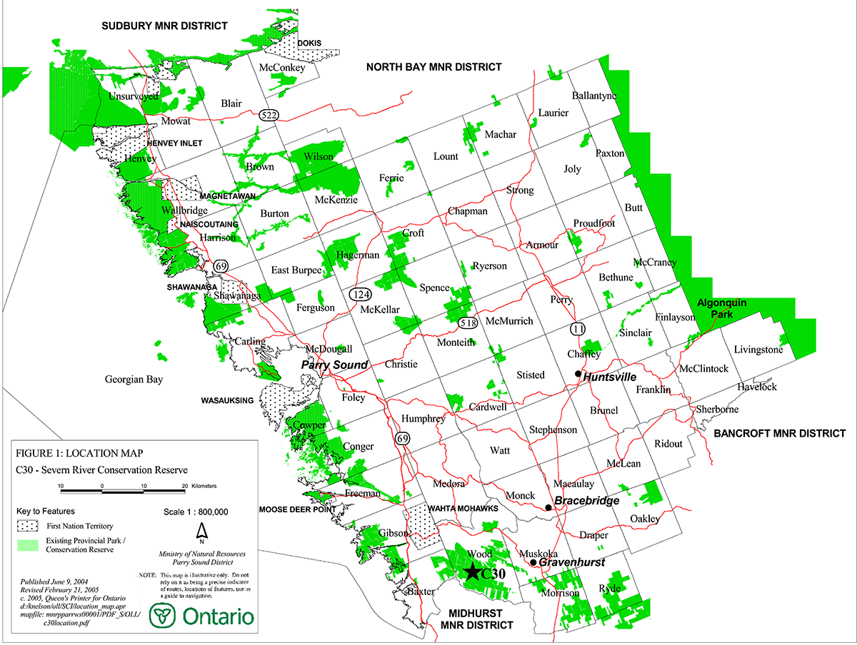
Figure 1: Location of Severn River Conservation Reserve
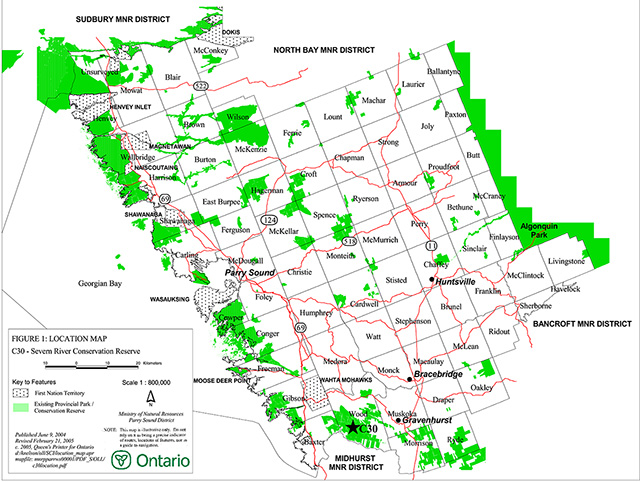
Enlarge figure 1 location of Severn River Conservation Reserve
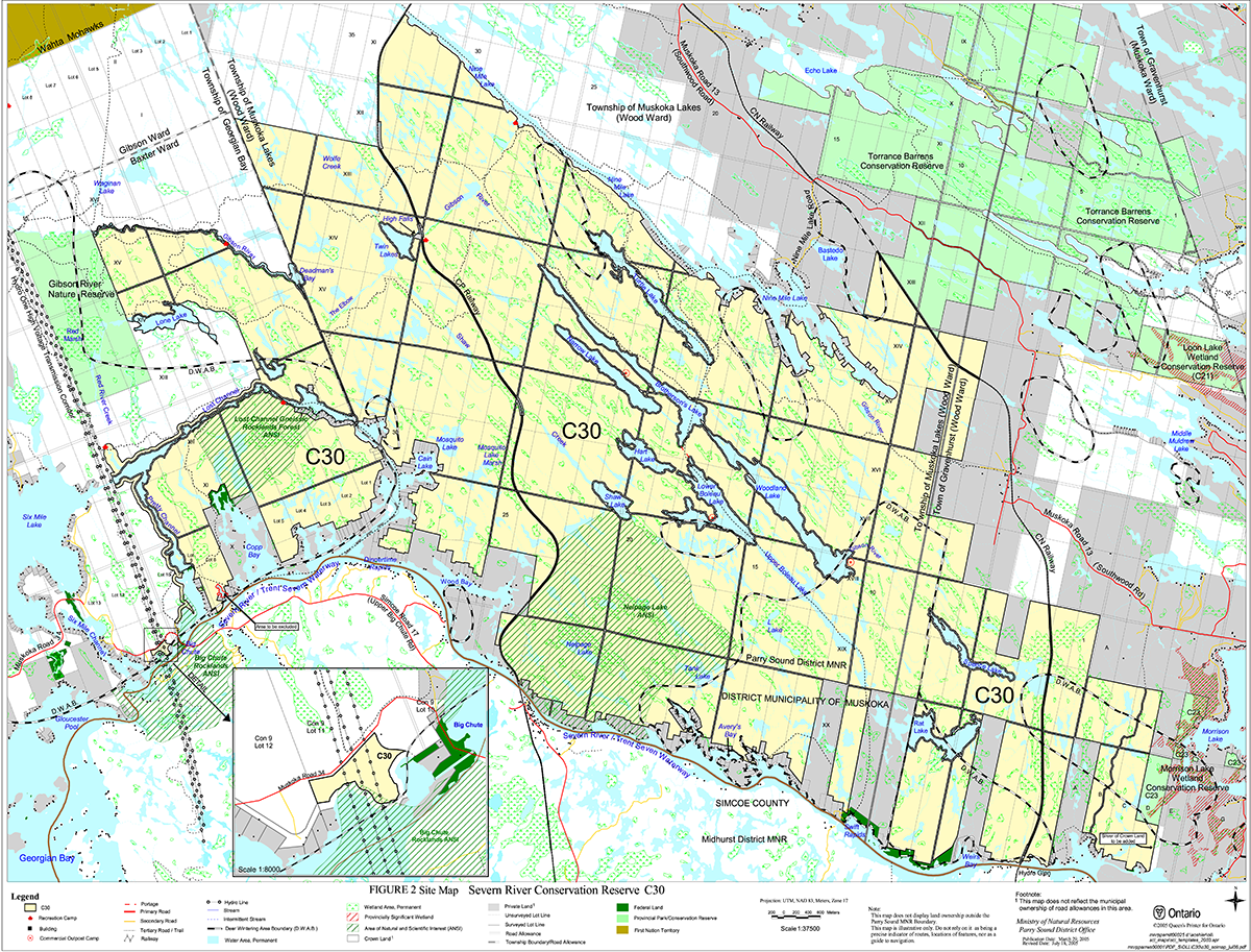
Figure 2: Site Map – Severn River Conservation Reserve
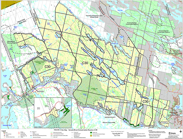
Enlarge figure 2 site map – Severn River Conservation Reserve
1.0 Introduction
Ontario’s Living Legacy, the result of an extensive planning process that began in early 1997, culminated in the approval in July 1999 of a Land Use Strategy that identifies the intended strategic direction for Crown land in central and northern Ontario, including the completion of Ontario’s system of parks and protected areas. This process, which included public consultation, resulted in the recommendation for regulation of 378 new protected areas, including Severn River Conservation Reserve (C30).
Severn River Conservation Reserve is a 9927 hectare area of Crown land, located within the District Municipality of Muskoka. Its eastern boundary is approximately 10 kilometres west of the town centre of Gravenhurst. It lies within Wood Ward, in both the Town of Gravenhurst and the Township of Muskoka Lakes, and in Baxter Ward in the Township of Georgian Bay.
Severn River Conservation Reserve is linked to two conservation reserves: Morrison Lake Wetland Conservation Reserve to the east; and Torrance Barrens Conservation Reserve to the north. The northwest boundary of the site abuts Gibson River Provincial Nature Reserve. Much of its northwest and west boundaries adjoin Crown land, while most of its northeast boundary borders abut private land. The southern boundary is predominantly bordered by private lands, and elsewhere by the Trent-Severn Waterway, which is under the jurisdiction of the Federal government.
Most of its northeast boundary and much of the southern border (along the Severn River), abut private land. While some of these properties are immediately adjacent to or partly surrounded by this site, they are not a part of the conservation reserve.
Severn River Conservation Reserve, in Hills' ecological Site District 5E-7, contains a number of important core natural heritage areas that have been inventoried and protected by the Ministry of Natural Resources (MNR) as Areas of Natural and Scientific Interest (ANSI) since the early 1980s. These include Big Chute – Severn River Gneissic Rocklands (provincially significant), Lost Channel Gneissic Rocklands (regionally significant), and Neipage Lake Gneissic Rockland Forest and Wetlands (regionally significant). Portions of the area have also been municipally identified as Muskoka Heritage Areas.
The site is characterized by moderately rolling gneissic ridges with very thin soil cover. Open forests of white pine, red oak and white oak occur on the ridges and on some side slopes. Between these ridges, narrow linear wetlands with sedge grass meadows, leatherleaf or coniferous poor fens or open aquatic wetlands occur. Beaver activity is evident throughout this conservation reserve. This landscape provides habitat for a wide range of rare plant and animal species including the threatened eastern hog-nosed snake, and the threatened eastern Massasauga rattlesnake. There are also several large deer wintering areas which lie partly or totally within this conservation reserve.
The interior portions of this site are relatively rugged and remote. Recreationists, including hunters, anglers, canoeists and snowmobilers, actively use the area.
Conservation reserves are established under the authority of the Public Lands Act, Ontario Regulation 805/94. Severn River Conservation Reserve was established by Ontario Regulation 237/03 on June 28, 2003.
A Statement of Conservation Interest is prepared under the direction of Procedural Guideline A – Resource Management Planning (PL. Procedure 3.03.05). The purpose of this Statement of Conservation Interest is to identify and describe the values of Severn River Conservation Reserve. The Statement of Conservation Interest also outlines the activities that currently occur within the conservation reserve and provides guidelines for the management of current and future activities in the context of protecting the natural, recreational and cultural values.
At the time that this Statement of Conservation Interest was being prepared, the MNR was in the process of making the following 3 administrative corrections to the boundaries of this conservation reserve:
- Lot 8, Con 10, Baxter Ward: delete bed of small bay since this is under federal ownership (part of Trent-Severn Waterway) and therefore not under provincial jurisdiction
- Lot D, Con 20, Wood Ward: add sliver of Crown land in eastern part of lot to reflect original intent of site; and
- Lot D, Con 20, Wood Ward: ensure boundaries appropriately reflect adjacent private land
1.1 Background information
| Name | Severn River Conservation Reserve (C30) |
|---|---|
| Site Region/District | Georgian Bay Site Region, Site District 5E-7 |
| OMNR administrative region/district/area | Southern Region/ Parry Sound District/ Parry Sound Area and Bracebridge Area |
| Total area (ha.) | 9927 hectares |
| Regulation date | June 28, 2003 (O. Reg. 237/03) |
| First Nations | Robinson-Huron Treaty and Williams Treaty |
| OBM map sheets | 10 17 6000 49700, 6050 49700, 6100 49700, 6150 49700, 6200 49700, 6000 49750, 6050 49750, 6100, 49750, 6050 49800, 6100 49800 |
| Topographic Map | Penetanguishene 31 D/13 Gravenhurst 31 D/14 |
| UTM co-ordinates | 17T 61150 497470 (Centroid) |
1.2 Representation
Earth science representation:
Bedrock
The dominant rock types exposed are gneissic monzogranite and subordinate gneissic gabbro derived from metaplutonic protoliths of the Go Home Domain, Algonquin Terrane in the southwestern part of the Central Gneiss Belt of the Proterozoic Grenville Province.
Surficial
A large area of low relief bedrock barrens interspersed with numerous lakes and wetlands. The surficial deposits of thin discontinuous till are Late Wisconsinian in age, and along with recent organic deposits in the wetland areas, are typical components of the Quaternary Era in southern Ontario.
Life science representation:
Severn River Conservation Reserve occupies a large area of open and treed rock barrens with a broad range of peatland and wetland types, numerous small lakes, and two major river corridors. This site protects a variety of habitats that support a high number of nationally and provincially rare vascular plant species, with both northern and southern floristic affinities. It contains three important core natural heritage areas that have been inventoried and protected by MNR as Areas of Natural and Scientific Interest (ANSI), and which have been municipally identified as Muskoka Heritage Areas. The area provides habitat for 21 provincially significant flora and fauna species.
Cultural resources representation:
Neither detailed cultural research nor inventory has been carried out for this conservation reserve.
Recent regional evaluation (OMNR, 2003) shows that this conservation reserve contains areas that have a high potential for cultural heritage sites. Allen (2004) has identified some pre-1900 logging era evidence, and also considers the area to have high potential for evidence of use by First Nation people from before European contact.
Recreational opportunities:
A recreational inventory report was prepared for this site based on existing knowledge and data sources of MNR staff, as well as site visits (Gavel, 2003). The large size of this area and its surroundings, and the combination of open and treed rock barrens, river corridors and numerous small lakes, give this conservation reserve good potential for a number of activities. Currently, it is used for hunting, angling, snowmobile trails and cross country ski trails, canoeing, camping, hiking, and by all-terrain vehicles.
1.3 Survey work
| Survey Level | Earth science | Life science | Cultural | Recreational | Other |
|---|---|---|---|---|---|
| Reconnaissance | Duba & Frey, 2001 | Jalava, 2001 Kamstra, 1992 Macdonald, 1986 Oldham, 2001 Oldham & Weller, 2000 Reid & Bergsma, 1994 Varga, 1988 |
Allen, 2004 OMNR, 2003 |
Gavel, 2003 | None |
| Detailed | None | None | None | None | None |
| Requirement | None | Monitor the status/presence of significant species and associations. | Research to be encouraged | Monitor use impacts | None |
2.0 Values to be protected
The conservation reserve is located entirely within Hills' (1959) ecological Site District 5E-7. Values include earth science, life science and recreational/aesthetic values, with an emphasis on the life sciences.
2.1 Earth science:
(Earth science information, unless otherwise noted, is taken from Duba & Frey, 2001)
Bedrock:
Severn River Conservation Reserve is a very large area of low relief, sparsely forested bedrock barrens interspersed with numerous lakes and wetlands. The bedrock of the conservation reserve is within the Go Home Domain, Algonquin Terrane, in the Central Gneiss Belt of the Proterozoic Grenville Province (Lumbers & Vertolli, 2000 a & b).
The Grenville Province is the product of thrusting and imbrication of the crust to the northwest as it collided with a continental landmass to the southeast. The Grenville Orogeny, circa 1140 to 1070 million years ago, culminated more than 500 million years of crustal evolution. The eroded roots of the products of these events are displayed in the complexly metamorphosed and deformed rocks of the region (Easton, 1992b).
The Algonquin Terrane is one of the four lithotectonic terranes of the Central Gneiss Belt. The Go Home Domain is one of twelve structural domains of the Algonquin Terrane. This geological environment is part of the modern organization of the complex products of the mid-Proterozoic orogenic events (Easton 1992a & b). As such, their representation in Severn River Conservation Reserve contributes to the conservation of the Grenville Province continental accretion theme (Davidson, 1981).
The Go Home Domain consists of mainly felsic and subordinate mafic plutonic rocks that are separated by metasedimentary assemblages including calc-silicates, pelites and marbles. The plutonic and supracrustal rocks have undergone a complex polyphase deformation that produced two generations of folds, a dominant northwest-trending fold system coaxial with the stretching lineation and east-trending folds. The oldest rocks underlying the area are > 1460 million-years-old mafic-rich grey gneisses. These are intruded by 1460-1430 million-years-old anorthosite-mangerite-charnockite-granite suite diorite/gabbro monzodiorite, andesine monzogranite and monzogranite. The pink, laminated and augen textured monzogranite is the most abundant rock-type of the area. Three northeast-trending regional faults transect all the gneissic rocks.
The felsic and mafic metaplutonic rocks are typical representations of the Go Home Domain, Algonquin Terrane. However, numerous other compositional and structural elements of the Go Home Domain are probably absent in this conservation reserve. Within the Ontario Provincial Park system, the bedrock geological features observed in Severn River Conservation Reserve have regional significance.
Surficial:
The surficial deposits in this conservation reserve are Late Wisconsinian in age. The dominant Quaternary deposit is a thin, discontinuous till cover over a large part of the bedrock barrens. The wetlands are underlain by recent organic materials. Bedrock shows glacial striae, grooving, crescent gouges, and molded bedrock forms such as whalebacks give evidence of a southerly flow of glacial. Surficial geology of the conservation reserve is locally significant.
2.2 Life science:
(Life science information, unless otherwise noted, is taken from Jalava, 2001)
The conservation reserve is located within Hills' (1959) ecological Site District 5E-7. Life science significance is determined on the basis of the following criteria: representation, diversity, condition, ecological considerations and special features (Crins and Kor, 1998).
Representation:
Severn River Conservation Reserve is part of a discontinuous band of granite barrens extending from the Kaladar area in Eastern Ontario to Georgian Bay up to and including the French River. These granite barrens present a distinctive habitat type within Southern Ontario with unique environmental factors and specialized plants and animals. As they have limited occurrence in Southern Ontario, granite barrens warrant protection. (Catling and Brownell, 1999).
Severn River Conservation Reserve protects a vast landscape along the southern edge of the Canadian Shield and is host to exceptional biological diversity. It provides representation of vast tracts of open and treed rock barrens, a broad range of peatland and wetland types, numerous small lakes, two major river corridors, and a variety of mixed, deciduous and coniferous forest types having both southern and northern floristic affinities in Hills' ecological Site District 5E-7. Of particular significance are aquatic and shoreline habitats that support a high number of nationally and provincially rare vascular plant taxa, and woodlands with warm microclimates at the south end of the site that sustain a number of provincially and locally significant southern and prairie-associated taxa. The conservation reserve provides habitat for 21 provincially significant flora and fauna and over 50 locally rare plant species.
Because the Severn River partly drains a limestone plain, a number of locally rare calciphilic plant species also occur. The contact between the Canadian Shield of central Ontario and the Paleozoic bedrock of southern Ontario is known to be a zone of high biodiversity. The combination of all these factors makes Severn River Conservation Reserve one of the most biologically diverse sites in central Ontario.
The conservation reserve is found within the interior gneissic barren rocklands physiographic region (Macdonald 1987, Brunton 1993). According to current Ontario Ministry of Natural Resources (OMNR) digital biophysical mapping, the site is located within the "weakly broken bare bedrock plain (organic)" biophysical unit (VIIa-7) (Noble 1983). Severn River Conservation Reserve is situated near the southern edge of the Canadian Shield, the largest continuous area of Precambrian bedrock in the world. The site is underlain by several broad bands of gneissic bedrock that arc in a north to south-westerly direction through the conservation reserve. These bands of bedrock are separated by narrow linear faults, which are most evident in the northeastern half of the site. The site’s hydrology and vegetation patterns are strongly influenced by these bedrock patterns.
The details of the landform - vegetation patterns of this conservation reserve are described in detail in "Natural Heritage Area - Life Science Checksheet: Severn River Conservation Reserve (C30). OMNR Parry Sound." (Jalava, 2001) This Statement of Conservation Interest provides the following broad summary of that report.
The northwest portion of the conservation reserve includes the Gibson River watershed west of the Canadian Pacific Railway line. It covers the area from the Gibson River Provincial Nature Reserve boundary to the Canadian Pacific Railway (CPR) line at High Falls. It is predominantly rolling gneissic rockland with a deeply incised, fault-controlled river valley extending across it (Macdonald 1986). Extensive, fire-successional dry open rock barrens (vegetated with grasses, lichens and mosses, with scattered shrubs of common juniper (Juniperus communis) and lowbush blueberry (Vaccinium angustifolium)) and treed rock barrens (dominated by combinations of white pine (Pinus strobus), red oak (Quercus rubra) and white oak (Q. alba), with a well-developed low shrub layer of common juniper and lowbush blueberry) cover 40% to 50% of the uplands in this section of the site.
Along the Gibson River just west of Twin Lakes, there is a small, rather unusual talus community with a very sparse tree/sapling layer of American elm (Ulnus americana).
Deeper-soiled ridge slopes are dominated by the same tree species as the treed barrens, but often have red maple (Acer rubrum), white birch (Betula papyrifera), large-tooth aspen (Populus grandidentata) or, in somewhat richer sites, sugar maple (Acer saccharum) as co-dominants or sub-dominants species. Balsam fir (Abies balsamea) is frequent in the sapling layer of these usually young stands. The herbaceous layer is usually extensive. Young to intermediate-aged dry-fresh sugar maple – red oak and fresh-moist sugar maple– American basswood (Tilia americana) stands occur on deeper soils north of the Gibson River and west of Twin Lakes, the former on lower ridge slopes and south-facing sites, and the latter on moist lowlands.
Relatively rich, intermediate-aged stands also occur along the Gibson River valley, and are dominated by red maple and sugar maple, often with white birch as a co-dominant, and with large-tooth aspen and yellow birch (Betula allegheniensis) as secondary species. There is often a fairly well-developed shrub layer in these richer stands.
Wetland and open water communities cover approximately 20% of the northwest section of the conservation reserve. Depressions on the bedrock plain support several open water beaver ponds and small lakes. These ponds are often fringed with meadow marshes or shallow marshes. Some of the larger beaver ponds and small lake edges support narrow thicket swamps. Speckled alder (Alnus incana) thicket swamps and black ash (Fraxinus nigra) deciduous swamps are occasional in small depressions in bedrock forest stands. Various peatlands have also formed on the bedrock plain, particularly on the flatter ridges.
The Gibson River shorelines and slow-moving open water support a variety of wetland communities. These include shallow marshes, meadow marshes and shrub fens.
The southwest area includes the Severn River watershed west of the Canadian Pacific Railway in the southwestern portion of the conservation reserve. It includes the northern tip of the Big Chute ANSI and all of the Lost Channel Gneissic Rocklands ANSI. It consists of a complex of wetlands and thin-soiled bedrock-controlled uplands roughly bounded by the Big Chute, the Severn River, Pretty Channel and upland terrain just north of Lost Channel.
Much of the central portion of this section is relatively flat, with a thin discontinuous drift of glacial tills over gneissic bedrock ridges. Well-defined bedrock valleys occur along Pretty Channel and the central and western portions of Lost Channel. The area is drained by small creeks, and is much affected by beaver activity. The gorge in the northern portion of Lost Channel is considered an uncommon landform feature in Muskoka (Kamstra 1992, Reid and Bergsma 1994).
Up to 60% of the uplands in the Lost Channel area are mixed and conifer forests of white pine, usually co-dominant with white birch and large-tooth aspen in younger stands, and red oak and/or red maple, with white oak and sugar maple as occasional secondary dominants in older examples. Notable among the upland forests here is a sub-mature, mixed upland forest of red maple – white birch – white pine –large-tooth aspen – white spruce (Picea glauca) (Macdonald, 1986).
Scattered dry open rock barrens and treed barrens also occur, covering between 5% and 10% of the section. Open barrens are most common just east of Pretty Channel and to the northeast of Lost Channel. The barrens have a similar species composition to those described for the northwest section.
Sugar maple -American beech (Fagus grandifolia) - hemlock (Tsuga canadensis) forests occur on deeper soils on slopes and low-lying areas between bedrock ridges. Intermediate-aged sugar maple stands usually have large-tooth aspen, red oak and occasionally American basswood as secondary dominants, often with extensive sapling layers of ironwood (Ostrya virginiana) and striped maple (Acer pensylvanicum). An unusual fire-successional white pine – bur oak (Quercus macrocarpa) woodland is found just north of Big Chute. A cool, moist balsam fir forest in the Lost Channel ANSI is also uncommon in this part of Muskoka (Kamstra 1992, Reid and Bergsma 1994).
A wide range of wetland communities is found in the Big Chute – Lost Channel area, covering approximately 15% of this section of the conservation reserve. Beaver ponds are widespread, with abundant floating-leaved and submerged aquatic vegetation. Numerous thicket swamps occur in bedrock depressions and along the fringes of some beaver ponds. Also associated with the fringes and shallow sections of beaver ponds are various meadow marshes and shallow marshes. Moist to wet deciduous swamp forests are also present in some of the bedrock depressions and are dominated by red maple, with black ash a secondary dominant (Kamstra 1992).
The most extensive peatlands occur in the northern part of the section, just south of Lost Channel. These include a graminoid poor fen community, surrounded by a 15 hectare leatherleaf – Virginia chain fern shrub bog, with extensive dead standing trees, indicating beaver flooding in the past. This large shrub bog is, in turn, surrounded by a three-way sedge meadow marsh. To the south of this large peatland, there is a smaller black spruce – tamarack treed bog. Shore fens occur along the fringes of a number of beaver ponds and lakes.
The aquatic and shoreline communities of the Big Chute – Pretty Channel area support a number of taxa of provincial and national significance, and a variety of locally significant species. In the Big Chute ANSI report, according to Varga (1988) "the more shallow edges of the Severn River, in particular the gradually sloping protected bays, support a remarkably rich submerged/floating/deep emergent aquatic community….These aquatic communities are dominated by a submerged layer of tape-grass (Vallisneria americana), bushy naiad (Najas flexilis), Canada waterweed (Elodea canadensis) and a rich assortment of 15 species of pondweed (Potamogeton spp.), 4 species of water-milfoil (Myriophyllum spp.) and 3 species of quillwort (Isoetes spp.)."
The southeast part of Severn River Conservation Reserve, east of the Canadian Pacific Railway, contains the Severn River watershed and a small section of the upper portion of Shaw Creek watershed (which drains into the Gibson River at Twin Lakes). It includes previously recognized significant natural areas at the Neipage Lake ANSI (Macdonald 1986, Kamstra 1992, Brunton 1993, Reid and Bergsma 1994) and the McDonald’s Cut Deer Yard (Macdonald 1986). The Lower Swift Slope (Kamstra 1992, Reid and Bergsma 1994) Muskoka Heritage Area is on the north shore of the Severn River on private land immediately adjacent to the conservation reserve. The section is notable for its warm, south-facing slopes along the Severn River corridor, which support a high number of southern plant species and several taxa with prairie and savannah affinities. Behind these slopes are relatively rich deciduous forests also with southern elements, which grade northward into a more typical Canadian Shield mosaic of white pine – red oak woodlands, rock barrens, beaver ponds, and extensive peatlands such as those in the Neipage Lake area. Overall, deciduous forests cover approximately half of this section of the site, mixed hemlock forests 5% to 10%, rock barrens 10%, and pine – oak bedrock woodlands 15%, wetlands and peatlands 15%, and open water 5%.
The Severn River has several shallow embayments in this section of the conservation reserve. The shallowest and least disturbed of these support rich, diverse aquatic beds of submerged, floating-leaved and emergent species. A number of locally significant flora occur in these shallow waters. Adjacent to this aquatic community is a rich red maple swamp with black ash and bur oak as associates, and an extensive low shrub layer dominated by poison ivy (Rhus radicans). The upper portion of another embayment supports a yellow birch deciduous swamp with black ash a secondary dominant, with abundant sugar maple saplings.
The area above the wave wash zone on the north shore of the Severn River between the CPR and CNR railway lines was found to support many of the more interesting plants of the conservation reserve. These include a number of locally significant taxa. Above the shore, steep, dry, south-facing slopes of the Severn River corridor support open, savannah-like stands of white pine – red oak – white oak – red maple. Behind these slopes, relatively deep pockets of glacial drift support a variety of relatively rich, fresh to moist deciduous forests dominated by sugar maple mixed with American basswood, yellow birch and/or white ash (Fraxinus americana). Smaller mixed and coniferous stands of white pine, red pine and eastern hemlock occur in the transition into the bedrock-controlled landscape that predominates in much of the northeastern section of the conservation reserve.
Open rock barrens are prevalent on the relatively flat bedrock plain that drains into the Morrison Lake Wetland, a provincially significant wetland that touches the east boundary of the conservation reserve. In this area over 50% of the uplands are open rock barren or white pine – red oak treed barren. Understorey composition is similar to other rock barren communities in the conservation reserve. The eastern end of the site also supports dry, relatively open white pine – white oak bedrock woodlands with well-developed low shrub layers of lowbush blueberry in more open stands and maple-leaved viburnum (Viburnum acerifolium) in stands subject to more shade. These woodlands are notable for the replacement of red oak by white oak. Elsewhere in the southeast site section, only the driest bedrock ridge crests support rock barrens, while shallow-soiled ridges and slopes sustain a mosaic of white pine – red oak – white oak forests, often with red maple, large-tooth aspen, white birch and American basswood as associates.
Poorly-drained depressions between the bedrock ridges usually have moist red maple stands, often mixed with white birch. Speckled alder thicket swamps also frequently occur in such depressions, often with an accumulation of peat. Inundated alder thicket swamps occur along the Canadian National Railway line in the eastern part of the southeast site section, with woody vegetation dying off as a result of beaver flooding combined with the hydrological impacts of the railroad. This area also supports a relatively mature tamarack – black spruce fen. Other communities occurring on strongly bedrock-controlled landscape include various meadow marshes along beaver pond fringes, as well as small wetlands dominated by Virginia chain fern bogs in poorly-drained depressions.
The Neipage Lake area was originally identified by Macdonald (1986) as a regionally significant Area of Natural and Scientific Interest (ANSI) for its "medium representation of well developed interior gneissic rockland forests and barriers, and basin/impoundment wetlands". The area includes three distinctive bog lakes and their immediate watersheds. Neipage Lake is the largest of the bog lakes. The two others are officially unnamed, but have been called "Little Neipage Lake" (north of Neipage Lake) and "Keyhole Bog" (east of Neipage Lake) (Kamstra 1992). The Neipage Lake Complex consists of moderately rolling gneissic ridges and bogs, ponds or swamps in low areas. Soil is thin in most areas, with numerous exposed bedrock outcrops. Peat deposits have accumulated in low areas. Virtually all stages of peat bog development are present within the complex. Neipage Lake is an extensive open bog mat that has encroached around islands. Keyhole Bog contains a ring of open treed bog around a deep pool of water, but is surrounded by low shrub bog that has been flooded in the recent past. A pond in the south contains a floating, donut-shaped bog mat. Closed treed bogs occur in depressions south of Neipage Lake. Small Virginia chain fern bogs and shrub bogs are found in smaller depressions scattered throughout the area. Less acidic beaver meadow wetlands are also present at various successional stages.
The northeast section includes the Gibson River watershed east of the Canadian Pacific Railway line, covering over half of the conservation reserve. This section is characterized by long, narrow, linear bedrock ridges that sustain characteristic Canadian Shield rock barrens and shallow-soiled woodlands, which are interspersed with lakes, beaver ponds and a variety of wetlands in bedrock depressions and faults. The Gibson River follows a rectilinear path through the site, with a number of sharp right-angled turns. Soils are generally very shallow in the northeast site section, due to heavy glacial scouring. As a result, extensive open and treed rock barrens cover between 20% and 25% of the section, and very shallow-soiled white pine - oak woodlands covers another 30% to 35%. Various peatlands, meadow marshes, shallow marshes and thicket swamps, often associated with beaver flooding, cover 25% to 30% of the section, and open water about 15%. Many of these lakes and ponds have naturally fluctuating water levels and some of the sandy and peaty shorelines provide ideal habitat for disjunct Atlantic Coastal Plain flora. Deeper-soils in the site section support moist deciduous stands of red maple, sugar maple and mixed hemlock forests, covering less than 5% of the area.
Treed barrens are more common in this part of the conservation reserve than elsewhere. The open rock barren and treed rock barren communities are generally similar in composition to those described for other site sections, with white pine and red oak predominant, occasionally with red maple, white oak, large-tooth aspen or white birch, as secondary species or co-dominants. Slopes and bedrock plain with slightly deeper soil deposits support white pine – red oak woodlands, and pure white pine coniferous stands, with species composition similar to those elsewhere in the conservation reserve. The treed barrens and dry pine – oak woodlands are occasionally flanked by deeper sandy soils that support dry-fresh red oak – white oak or red oak – red maple stands. Other sandy-soiled sites support conifer stands of red pine, often co-dominant with white pine, with one extensive example occurring on the south and west shores of the large island on the north side of Rat Lake.
Moist depressions between bedrock ridges sustain young to intermediate-aged red maple forests, usually with white birch or large-tooth aspen as secondary dominants. A few widely-scattered valleys elsewhere in the northeast site section have sufficient soil to support sugar maple – white birch – large-tooth aspen stands.
The northeast site section has the highest percentage of wetlands and open water of any of the sections of the conservation reserve. This is largely due to the extent and prevalence of poorly-drained bedrock depressions and faults. Many of the smaller depressions in rolling, wooded terrain support thicket swamps dominated by speckled alder. Some of these thicket swamps have succeeded into black ash and red maple deciduous swamps. There is a tamarack coniferous swamp at the eastern end of the conservation reserve that occurs in a mosaic with mountain holly and speckled alder thicket swamps along the CNR line.
Meadow marshes, shallow marshes and peatlands in various stages of succession are associated with the many beaver ponds, fault-line channels and bedrock depressions in the northeast site section. Wet peatland fringes and floating broken peat mats in lakes and beaver ponds often have graminoid shore fens. More successionally-advanced and often slightly drier shrub fens are very common in the site section. Wet beaver pond edges and recently flooded wetland support a variety of typical Canadian Shield marshes and meadow marshes. Eastern buttonbush thicket swamps also occur along the shores and in shallow bays of some of the larger lakes, and often are co-dominant with three-way sedge. There is a large shallow marsh dominated by broad-leaved cattail and Canada blue-joint along the CPR line in the epicentre of the conservation reserve, probably present due to hydrological disturbance resulting from the construction of the railroad.
Small "perched" peatlands are common on the bedrock plain, and include several small open bogs. More extensive bogs are found in larger ponds and lake embayments with little or no water flow. Good examples are found at the north end of Rat Lake, at the south end of Nine Mile Lake, at a pond west of Narrow Lake and, based on aerial reconnaissance, around "L" Lake (just west of Upper Boleau Lake).
Condition:
Overall, Severn River Conservation Reserve is a vast area with wilderness qualities and many relatively pristine sites. Most of the drier bedrock-controlled uplands, including the open and treed rock barrens and pine – oak woodlands have been burned during the past 100 years, probably as the result of both natural and human-caused fires. Many of the moister, deeper-soiled forests also show fire history. Selective logging has also taken place in the site over the past several decades, and only a small fraction of the forest stands are semi-mature to mature. There are, nevertheless, a number of impressive stands, even along the Severn Corridor, with notable examples north of the small bay east of Avery’s Bay, as well as on the large island in Rat Lake. The interior wetlands are generally undisturbed except for natural beaver impacts.
The site is entirely roadless, giving it significant wilderness qualities. However, two major railway lines bisect the site, there is a major power transmission corridor along the western boundary, and a municipal road cuts through the site near its eastern boundary. Smaller power transmission lines service cottage lots along the north shore of the Severn River. The site is penetrated by a network of authorized snowmobile trails and cross country ski trails, and several unauthorized trails, some of them used occasionally by all-terrain vehicles during the warmer months.
Diversity:
Severn River Conservation Reserve sustains an array of 81 different vegetation community types on the weakly broken bare bedrock plain (organic) landform type (biophysical unit VIIa-7). These natural communities provide habitat for an exceptional diversity of 604 vascular plant taxa, making this one of the most botanically diverse sites in central Ontario. At least 480 vascular plant taxa were found during the 2001 inventory. An additional 132 taxa have been recorded in previous studies (Kamstra 1992, Macdonald 1986, Varga 1988). Of these, a high proportion (92%, or 553 species) is native to central Ontario. This represents 52% of the total number of native plant taxa known for the District of Muskoka, and almost 30% of all native plant taxa recorded in Ontario.
Ninety species of birds were observed during the 2001 site visits and in previous studies (Kamstra 1992), with at least 85 of them showing evidence of breeding within the site. Fifteen species of mammals have been recorded at the site, including evidence of three large mammal species: black bear, moose and white-tailed deer. Ten reptile species and a high diversity of 16 amphibian species have been recorded at the site during the present and previous studies (Kamstra 1992). An additional 5 reptile and 2 amphibian species have been recorded within the site, or in its immediate vicinity, based on Ontario Herpetofaunal Atlas range maps (Oldham and Weller 2000). These totals represent almost 60% of the native herpetofauna recorded in Ontario. Twenty-two species of butterflies have been recorded at the site, 21 of them during a previous study of the Neipage Lake and Lost Channel areas (Kamstra 1992).
Ecological considerations:
Severn River Conservation Reserve is part of a 35,000 hectare roadless wilderness area. This wilderness is broken only by two railroads, a power transmission corridor, a municipal road, cottage and canal development along the Severn River, the minor Swift Rapids access road, and trails used by snowmobile and all-terrain vehicles. This roadless area includes the Gibson River Provincial Nature Reserve, Morrison Lake Wetland Conservation Reserve, a major section of the Trent Severn Waterway, much of the Wahta First Nation territory, and the Lost Channel, and Neipage Lake Regionally Significant Life Science ANSIs, as well as large, undeveloped intervening areas of Crown land. Only minor roads separate this area from protected areas at Torrance Barrens Conservation Reserve and Loon Lake Wetland Conservation Reserve in the northeast, the Matchedash Bay Provincial Wildlife Area and Big Chute Rocklands ANSI to the southwest, and Six Mile Lake Provincial Park to the northwest. This wilderness provides extensive habitat for area-sensitive fauna such as black bear and moose, red-shouldered hawk, and a number of forest-interior bird species.
The site protects much of the Gibson River watershed, and a significant portion of the lower Severn River watershed. Its extensive wetlands, such as those within the Neipage Lake complex, regulate the release of surface and ground waters into the surrounding hydrological system. The conservation reserve protects many hundreds of kilometres of ecologically-sensitive and biologically diverse shoreline habitat.
Severn River Conservation Reserve contains parts of a number of deer wintering areas. A large deer wintering area in the Boleau/Rat Lake area is the subject of active management, and is locally important to local deer populations. There has been a history of deer habitat management in various locations in the conservation reserve dating back at least to 1970.
Special features:
Severn River Conservation Reserve sustains an exceptional array of provincially and locally significant flora and fauna. These include 21 provincially rare flora and fauna. At least 47 of the site’s vascular plant taxa are rare in the District of Muskoka (Oldham 2001), and 50 are considered rare in ecodistrict 5E-7 (Crins 1997). Another 66 vascular plant taxa are uncommon in the District of Muskoka (Oldham 2001). This high number of significant flora is in large part attributable to the fact that the site occurs near the contact between the Precambrian Canadian Shield and the Paleozoic limestone bedrock to the south. As a result, calcareous deposits are present along the site’s southern boundary, the effect of post-glacial inundation by various lakes and rivers. The site’s southern location in Muskoka also results in the presence of several flora and fauna near their northern range limits. South-facing slopes along the Severn River corridor also have dry, warmer-than-normal microclimates, resulting in conditions suitable for species associated with prairies and savannahs. The site also has ideal habitat for disjunct Atlantic Coastal Plain flora, which are geographically concentrated in the southern Georgian Bay / southern Canadian Shield region in Ontario. Another important contributor to the presence of such an array of rare flora and fauna is the size of the conservation reserve and the relatively undisturbed wilderness beyond the site.
Provincially significant fauna and flora
Buteo lineatus Red-shouldered Hawk COSEWIC - Species of Special Concern, MNR - Species of Special Concern
There were six observations of red-shouldered hawks in the conservation reserve during the 2001 study. These include sightings of territorial adults and recently fledged young, confirming breeding within the site.
Sistrurus catenatus catenatus Eastern Massasauga Rattlesnake COSEWIC-Threatened, MNR - Threatened
There are numerous records of the nationally and provincially threatened and globally rare eastern Massasauga rattlesnake for Severn River Conservation Reserve and surrounding area (NHIC 2001). The frequency and distribution of records and the presence of abundant suitable habitat from Six Mile Lake Provincial Park (to the west of the site) northeast through the site to the Torrance Barrens and Loon Lake conservation reserves, suggests that there is a sizable, continuous population in the area.
Eumeces fasciatus Five-lined Skink COSEWIC - Species of Special Concern, MNR - Species of Special Concern
There are numerous records of five-lined skink for the site and its surrounding area (NHIC 2001). The frequency of observations suggests that Ontario’s only lizard is widespread and fairly common in Severn River Conservation Reserve area.
Heterodon platirhinos Eastern Hog-nosed Snake COSEWIC - Threatened, MNR-Threatened
There are several records of this nationally and provincially rare snake for Severn River Conservation Reserve and its immediate vicinity, from the 1930s to the 1990s (NHIC 2001). These include recent records from the Big Chute, Swift Rapids and Lost Channel areas. The Ontario Herpetofaunal Atlas shows a concentration of records of this species in the southeastern Georgian Bay coastal area, with only a few other scattered nodes elsewhere in Ontario (Oldham and Weller 2000). The conservation reserve probably protects habitat for what is one of the most important populations of eastern hog-nosed snake in the province.
Carex trisperma var. billingsii Billings' Three-seeded Sedge
This inconspicuous variety of tree-seeded sedge, currently considered provincially rare, was found to be fairly common in a Leatherleaf bog near the southeast end of Nine Mile Lake during the 2001 study. It is also a dominant or co-dominant in an open bog north of Neipage Lake.
Echinochloa muricata Prickly Barnyard Grass
Juncus acuminatus Sharp-fruited Rush This rush was collected by Varga (1988) near the Severn River shore in the Big Chute area.
Polygonum careyi Carey’s Knotweed
The provincially rare Carey’s knotweed was found to be locally abundant during the 2001 study in a meadow marsh at the edge of a shallow beaver pond on the Severn River, and occurring in several beaver ponds in the Neipage Lake area. It was also collected at Big Chute by Varga (1988).
Carex folliculata Long Sedge
The provincially rare long sedge was collected during the 2001 study in a Tamarack fen near the north-central part of the conservation reserve, within 100 metres of the north shore of the Gibson River. It was also collected at Big Chute by Varga (1988). This nationally and provincially rare species is considered uncommon in the District of Muskoka (Oldham 2001).
Sagittaria graminea var. cristata Crested Sagittaria
This provincially rare arrowhead was observed during the 2001 study in a shallow marsh on the east side of a narrow on the Severn River. It was also collected by Varga (1988) in the Big Chute area in 1988. This species is considered uncommon in the District of Muskoka (Oldham 2001).
Isoetes engelmannii Engelmann’s Quillwort COSEWIC-Endangered
The Severn River location at Big Chute is one of only two known Canadian locations for this nationally endangered quillwort. A recovery strategy is in preparation.
Isoetes X eatonii Eaton’s Quillwort
Eaton’s quillwort is an extremely rare hybrid (of I. engelmannii and I. echinospora) in Canada. It has been found near the entrance to Pretty Channel just northeast of Big Chute and in Lost Channel. This hybrid is considered rare in the District of Muskoka (Oldham 2001).
Juncus militaris Bayonet Rush
Small emergent stands of bayonet rush were found during the 2001 study along the western shore of the large Rat Lake island and along the shore near the southeast end of Nine Mile Lake. This Atlantic Coastal Plain disjunct is considered uncommon in the District of Muskoka (Oldham 2001).
Panicum spretum Eaton’s Panic Grass
This species was collected during the 2001 study in an Atlantic Coastal Plain meadow marsh on Rat Lake. There is also a previous record with few details available for Nine Mile Lake (NHIC 2001). This species is considered uncommon in the District of Muskoka (Oldham 2001).
Platanthera blephariglottis White-fringed Orchid
Populations of white-fringed orchid were found at both the Neipage Lake and Lost Channel ANSIs in bog habitat in 1991 (Kamstra 1992).
Polygonum arifolium Halberd-leaved Tearthumb
A population of this provincially rare species was found during the 2001 study just southeast of the Neipage Lake ANSI. This species is considered rare in the District of Muskoka (Oldham 2001).
Rhexia virginica Common Meadow-beauty
Populations of common meadow-beauty were found during the 2001 study at several locations along peaty and sandy shorelines at the southeast end of Nine Mile Lake, and along the western shore of the large Rat Lake island. Common meadow-beauty is an Atlantic Coastal Plain disjunct species.
Sporobolus asper Rough Dropseed
This provincially very rare grass was collected by Varga (1988) in 1987 in dry acidic rock barren habitat near the Severn River shore in the Big Chute area.
Triadenum virginicum Marsh St. John’s-wort
The provincially rare marsh St. John’s-wort was recorded at seven widely separated locations within the conservation reserve during the 2001 study. It was found in various open fen and meadow marsh communities in beaver-flooded wetlands.
Utricularia geminiscapa Hidden-fruited Bladderwort
This bladderwort was collected by Kamstra (1991) in the Neipage Lake area. This species is considered rare in the District of Muskoka (Oldham 2001).
Xyris difformis var. difformis Carolina Yellow-eyed Grass
Populations of small Carolina yellow-eyed grass were discovered at five widely-separated locations in the conservation reserve during the 2001 study. It was found in both shore fen and sandy Atlantic Coastal Plain meadow marsh habitats.
There are also breeding records of the provincially uncommon prairie warbler (Dendroica discolor) for the Big Chute ANSI in the 1980s, as well as a high number of additional provincially and locally rare plant species for that site, immediately south of Severn River Conservation Reserve. The spotted turtle (Clemmys guttata), ranked a Species of Special Concern by "Species at Risk in Ontario" list, in April 2004, and ranked Threatened by COSEWIC, was also discovered in the Big Chute ANSI in the 1980s (NHIC, 2001), and there is abundant wetland habitat for this secretive turtle in the conservation reserve.
2.3 Cultural values:
While no specific cultural studies or inventories have been undertaken within the conservation reserve, and no major cultural resource values have been evaluated or identified to date, recent regional evaluation (OMNR, 2003) (which provides generalized broad-brush mapping) and other evidence (Allen, 2004) shows that this conservation reserve contains areas that have a high potential for cultural heritage sites. Allen (2004) believes archaeological investigation will show evidence of use of the Gibson River watershed, by First Nation people from a time before European contact, with a possible link between the Severn River and the Gibson River within the conservation reserve area. He also reports on actual and anecdotal evidence of the pre-1900 logging era, namely water control structures associated with timber access and movement.
2.4 Recreational/aesthetic values:
Severn River Conservation Reserve is generally recognized as providing wilderness-type recreation experiences, due to the large size of this area and its surroundings; the landscape of rock barrens, river corridors and numerous small lakes; its relative wilderness; and its proximity to large population centres. It accommodates sport fishing, canoeing, camping, cross-country skiing, snowmobiling, big game hunting, hiking, and use by all-terrain vehicles.
Several of the lakes in the conservation reserve support a bass fishery, and are fished moderately. Most lakes are accessed by portage; however, there are also three authorized commercial fly-in fish camps located in the site.
A popular canoe route connects Nine Mile Lake to Weirs Bay on the Severn River. The route includes Turtle Lake, Brotherson’s Lake, Lower Boleau Lake, Upper Boleau Lake, Rat Lake and Rat Marsh. Another less frequently used route connects Nine Mile Lake to Georgian Bay via the Gibson River. Camping occurs on several of the lakes, associated with canoeing, angling, and back-country hiking.
There are two authorized Ontario Federation of Snowmobile Clubs (OFSC) trails within the conservation reserve, and there is also off-trail travel by snowmobile within the site. There are also long-standing authorized cross-country ski trails managed by the Five Winds Backcountry Touring Club (totalling about 38 kilometres) in the north portions of the conservation reserve. There is evidence of winter camping near these trails. There is apparently some back-country hiking that occurs within the site, mostly using portions of the cross-country ski trails and snowmobile trails.
There are also trails to private properties on the north shore of the Severn River.
Severn River Conservation Reserve is a long-standing traditional hunting area for moose, white-tailed deer and black bear. There are five Crown land recreation camps within the site, and most hunting originates from these and neighbouring private land.
All-terrain vehicles gain access to the conservation reserve by the snowmobile trails and long-standing unauthorized trails, presumably in connection with angling, hunting, and camping.
The distance of this conservation reserve from urban areas has resulted in a relatively pristine night sky, which enhances the sense of remoteness and wilderness of this site. Pristine night skies are considered a significant value, given the increasingly limited areas of southern and central Ontario that are not heavily affected by light pollution.
3.0 Management guidelines
MNR's Class Environmental Assessment for Provincial Parks and Conservation Reserves came into effect on January 10, 2005. All new MNR projects in conservation reserves, and any new approvals or permits issued, must meet the legal requirements of this Class Environmental Assessment, and any relevant amendments.
3.1 Land tenure:
Background:
Severn River Conservation Reserve consists of 9927 hectares of Crown land, located within the District Municipality of Muskoka. Its eastern boundary is approximately 10 kilometres west of the town centre of Gravenhurst. It lies within Wood Ward, in both the Town of Gravenhurst and the Township of Muskoka Lakes, and in Baxter Ward in the Township of Georgian Bay.
Most of its northeast boundary and its southern border, along the Severn River, abut private land. While some of these properties are immediately adjacent to or partly surrounded by this site, privately-owned lands are not a part of the conservation reserve. The southern boundary is bordered in many locations by the Trent-Severn Waterway, which is under the jurisdiction of the federal government.
The municipal road allowances that abut against or divide portions of this site are not a part of the conservation reserve, nor are the original shore road allowances along Nine Mile Lake, the Severn River, Pretty Channel, Lost Channel, or the many inland lakes within the site.
Two railway corridors cross the conservation reserve, Canadian Pacific Railway through the west side, and Canadian National Railway through the east side. Both corridors are excluded from the conservation reserve.
A major electrical power transmission corridor passes north/south just west of the conservation reserve, touching the boundary where it crosses Lost Channel, and crossing the small portion of the conservation reserve located on the Severn River, just downstream of Big Chute.
The Five Winds Backcountry Touring Club maintains about 38 kilometres of cross-country ski trails in the northern portions of the site, under the authority of a Land Use Permit. There are two authorized Ontario Federation of Snowmobile Clubs snowmobile trails that cross through the site.
There are three authorized (since 1979) fly-in fish camps located on Narrow Lake, Woodland Lake and Upper Boleau Lake. Their authority does not allow them to be used as hunt camps. Boat caches are found in a few locations throughout the site, with most being found on Turtle Lake.
There are five authorized Crown land recreation camps within the conservation reserve.
The conservation reserve is not within a Bear Management Area. It lies within four Bait Fish Blocks (PS216, PS218, PS219, and PS235). It is covered by parts of several registered trapline areas (BR03-N001-01, BR03- N002-01, BR03-N005-01, BR03-N022-01, BR03-N023-01, BR04-N046-01, HU05-N005-01, and HU06-N006-01).
A privately constructed dam is located at the outlet of Nine Mile Lake, maintaining the water levels for recreational purposes. It is owned and managed by the Nine Mile Lake Association, and is authorized by the MNR by land use permit.
Guideline:
The sale of Crown lands within the conservation reserve is generally not permitted. Exceptions will only be considered under unusual circumstances, such as where a pre-existing, adjacent, privately owned parcel has inadequate area for the installation of a septic system.
There are no plans by the MNR to acquire private lands to add to the conservation reserve.
The Bait Fish Blocks, currently assigned, are permitted to continue. The registered traplines are allowed to continue, but new trapline cabins are not permitted within the conservation reserve.
Commercial bear hunting service is not allowed within the boundaries of the conservation reserve. This site, or portions of it, cannot be incorporated into a Bear Management Area.
The existing recreation camps within the conservation reserve are permitted to continue. They may be eligible for "enhanced" tenure, but are not eligible for purchase of land (See Appendix 4). Where authorized in writing, the Ministry of Natural Resources would consider permitting transfer of ownership, or alterations to authorized recreational camps, so long as there are no negative impacts on the values of the conservation reserve.
New recreation camps are not permitted.
Under current policies, non-commercial boat caching is a free use of public land, and can continue. This use will be monitored to ensure that conservation reserve values are not being adversely impacted.
The two authorized snowmobile trails and the cross-country ski trails can continue to be authorized; their use will be monitored to ensure that conservation reserve values are not being adversely impacted.
While commercial timber harvesting is not allowed within conservation reserves, there are limited situations in which abutting land owners can harvest firewood for use on their adjacent property. Specifically, property owners and those with Crown land tenure who have no road access to their properties can apply for permits to cut limited amounts of firewood in the conservation reserve for their own use. This situation would apply only to the authorized recreation camps, fly-in fish camps and to water access cottages/camps that are on small parcels of private land adjacent to conservation reserve boundaries.
The Hydro One power transmission corridor is recognized as an accepted existing use. Changes to this transmission corridor where it crosses the conservation reserve, such as the additions of additional tower lines, must meet the requirements of Procedural Guideline B – Land Uses – Test of Compatibility (see Appendix 1) and any Environmental Assessment Act requirements.
3.2 Development:
Background:
There are no Crown owned buildings or other facilities within the conservation reserve.
According to Allen (2004) there is evidence of a blasted timber canal near the northwest end of Nine Mile Lake at Lot 28, Con. 12 Wood Twp, and a probable historic dam site just downstream of Nine Mile Lake. There may be remnants of other logging era structures along the Gibson River within the conservation reserve. A privately constructed modern dam is located at the outlet of Nine Mile Lake, maintaining the water levels for recreational purposes. It is owned and managed by the Nine Mile Lake Association, and is authorized by the MNR.
Two railways cross through the west (CPR) and east (CNR) sides of the site, although their corridors are excluded from conservation reserve boundaries.
The Hydro One electrical power transmission corridor which passes mostly to the west of the conservation reserve does cross the southwest tip just downstream of the Big Chutes.
Three authorized trail systems occupy conservation reserve lands. Two are OFSC snowmobile trails, and the third is a network of cross-country ski trails managed by Five Winds Backcountry Touring Club. Other long-standing trails also penetrate the perimeter of the conservation reserve in several locations.
Guideline:
New private access or resource access roads, and additions to or upgrading of existing roads are not permitted. There is no intention to develop or improve roads outside of the conservation reserve to improve access to this site.
Physical remnants of the late 19th century logging era will be documented and protected from destruction, but no extraordinary measures are proposed to preserve their current state.
Unauthorized works within the conservation reserve will be handled in accordance with the Public Lands Act, and any required removal of these works will be at the expense of those responsible.
The authorized dam managed by the Nine Mile Lake Association is allowed to remain as long as it is managed and maintained in good condition by the Association.
The Hydro One power transmission corridor is recognized as an accepted existing use. Changes to this transmission corridor, such as the additions of additional tower lines, must meet the requirements of Procedural Guideline B – Land Uses – Test of Compatibility (see Appendix 1) and any Environmental Assessment Act requirements.
In general, existing authorized recreational trails may be permitted to continue in conservation reserves as long as they do not impair the natural features and values for which the area is identified and as long as there are no significant environmental impacts. Accordingly, the two authorized snowmobile trails and the cross-country ski trails continue to be authorized. Their location and use will be monitored to ensure that conservation reserve values are not being adversely impacted. This is discussed further in Section 3.3 "Recreational Activities".
New recreational trails may be considered on a case by case basis, as is discussed in more detail in Section 3.3 "Recreational Activities". New recreational trails for motorized vehicles are discouraged and will only be considered under exceptional circumstances if the criteria identified in Section 3.3 have been demonstrated.
Any new development must meet MNR's commitments to protect cultural heritage values (see Section 3.7).
The development of new docks and water systems for adjacent or surrounded private lands is not restricted by the establishment of the conservation reserve. The MNR will consider site specific values when a work permit is required for such work.
No mineral exploration is permitted within this conservation reserve. This policy direction is based on a commitment made by the Ministry of Natural Resources and the Ministry of Northern Development and Mines in March 2002. This direction replaces that identified in the 1999 Ontario’s Living Legacy Land Use Strategy (OMNR, 1999), which stated that controlled mineral exploration would be permitted in new conservation reserves which were identified as having provincially significant mineral potential.
While there is no intent at present to provide or permit any new development in this conservation reserve that would require lighting, should this be considered at some point in the future the MNR will not allow unnecessary, undirected light pollution. This commitment recognizes the wilderness and biological values provided by a pristine night sky.
3.3 Recreational activities:
Background:
This area, which has characteristics that support wilderness type recreation, accommodates angling, canoeing, camping, hunting, snowmobiling, cross-country skiing, hiking, and use by all-terrain vehicles.
Many of the lakes within this conservation reserve are considered a good warm-water fishery, with most lakes supporting populations of largemouth bass (Micropterus salmoides). Lakes are accessed by portages from the Severn River or from Nine Mile Lake, or occasionally by existing trails. Three authorized fly-in fish camps also use the conservation reserve, with camps at Narrow Lake, Woodland Lake and Upper Boleau Lake.
Canoeing and associated camping occur on the network of lakes that connect Nine Mile Lake with Weir Bay on the Severn River, and along the Gibson River. Access to this area is generally from Nine Mile Lake, and parking, litter and camping on Nine Mile Lake are sometimes local issues. The campsites are also used by anglers, and some may be used by back-country hikers.
Motor boats are often used for angling in the interior lakes, and some concern has been expressed that this is not consistent with the wilderness potential of the site.
Big game hunting is a long-standing traditional activity in the conservation reserve. Five authorized recreation camps focus on this activity. Local residents and private land camps also use the site for hunting.
Snowmobiling occurs on the two authorized trails through the conservation reserve, and it is possible that some snowmobiling has occurred on unauthorized trails, or off trails. All-terrain vehicles use of trails has also been documented, and they too may use off-trail areas of the conservation reserve. Some of this use may be in association with angling, hunting and camping.
Cross-country skiing occurs within the site on authorized trails managed by the Five Winds Backcountry Touring Club. There is some evidence of some associated winter camping along these trails.
Guideline:
The known recreation activities that now take place in the conservation reserve are allowed to continue. Monitoring of existing and permitted activities will be undertaken as required to ensure that the conservation reserve values are not being adversely impacted.
Canoe tripping, angling and associated camping will continue to be accepted uses of the conservation reserve. These uses will be monitored. Portages and camping areas will be monitored to determine an appropriate level of use and maintenance. Cooperative monitoring and maintenance of portages, campsites and provision of thunder boxes will be encouraged through volunteer efforts. Overuse of the campsites and the subsequent potential to damage the significant natural environments is a concern. Where overuse develops, or where these uses threaten the values for which this conservation reserve was established, specific uses or areas might be limited, or closed.
The potential for conflict between the use of motor boats on the interior lakes of the conservation reserve and other traditional uses will be monitored in the context of the back-country nature of this site.
Mooring, camping and picnicking are allowed to continue on conservation reserve lands adjacent to the Trent-Severn Waterway, although it is noted that there are limited locations where the conservation reserve is adjacent to that waterbody. These uses will be monitored. Where over-use develops or where these uses threaten the values for which this site was established, specific use areas may be limited, or closed.
Recreational uses such as cross-country skiing, snowshoeing, hiking and wildlife viewing, are allowed to occur in the conservation reserve.
Hunting continues to be an accepted use in the conservation reserve.
In general, existing authorized recreational trails will be permitted to continue in conservation reserves as long as they do not impair the natural features and values for which the area is identified and as long as there are no significant environmental impacts. Accordingly, the two authorized snowmobile trails and the cross-country ski trails continue to be authorized, but their use will be monitored to ensure that conservation reserve values are not being adversely impacted. In particular, the use of all-terrain vehicles on the snowmobile trail corridors will be monitored, and their impact on conservation reserve values will be assessed.
The location of other pre-existing trails (trails that existed at the time of regulation of this conservation reserve), will be documented, and their use will be monitored to ensure that conservation reserve values are not being adversely impacted. Depending on the results of monitoring, some of the pre-existing trails may need to be redirected from sensitive areas or eliminated completely. There is no intent to mark or upgrade these trails.
New recreational trails may be considered on a case by case basis provided that they meet Procedural Guideline B - Land Uses - Test of Compatibility (see Appendix 1) and the MNR's Environmental Assessment Act requirements. Public consultation will generally be required during the consideration of changes to existing trails, and will always be required for new trails. New recreational trails will not be permitted in or within 50 metres of the Big Chute – Severn River Gneissic Rocklands (provincially significant), Lost Channel Gneissic Rocklands (regionally significant), or Neipage Lake Gneissic Rockland Forest and Wetlands (regionally significant) unless it has been demonstrated that there will be no negative impacts on the natural features or the ecological functions of these special areas.
New recreational trails for motorized vehicles will be discouraged and will only be considered under exceptional circumstances if the following have been demonstrated:
- there is a community need for the trail, as well as community support
- there are no alternative suitable locations outside the conservation reserve
- the trail location would be acceptable and suitable for four-season use
- the trail would meet the requirements applicable to all trails, as identified in the preceding paragraph
Any new trails must meet MNR's commitments to protect cultural heritage values (see Section 3.7).
Off-trail use of snowmobiles and all-terrain vehicles is only permitted for the direct retrieval of game.
Additional new recreational activities will be considered on a case by case basis provided they are consistent with maintaining the values of the conservation reserve and comply with Procedural Guideline B – Land Uses – Test of Compatibility (Appendix 1). Emphasis will be placed on activities that have a low impact on the environment of the conservation reserve.
3.4 Commercial activities:
Background:
There has been no recent commercial forest harvesting or mining activity within the conservation reserve.
There are three authorized (since 1979) fly-in fish camps located on Narrow Lake, Woodland Lake and Upper Boleau Lake. Their authority does not allow them to be used as hunt camps.
Boat caches are found in a few locations throughout the site, with most being found on Turtle Lake.
The conservation reserve is not within a Bear Management Area. It lies within four Bait Fish Blocks. It is covered by parts of several registered trapline areas.
These activities were discussed in Section 3.1 Tenure – Background.
Guideline:
Fur harvesting and bait fish harvesting operations are allowed to continue within the conservation reserve. New trapline cabins are not permitted within conservation reserves.
Provision of a commercial bear hunting service is not allowed within the boundaries of the conservation reserve. This site, or portions of it, cannot be incorporated into a Bear Management Area.
Under current policies, non-commercial boat caching is a free use of public land, and can continue. Commercial boat caches may only continue if they have been authorized.
Conservation reserve regulations do not permit mineral exploration, mining, commercial forest harvesting, hydroelectric power development, the extraction of aggregate and peat or other industrial uses (Public Lands Act, Ontario Regulation 805/94). Other new commercial activities must meet the requirements of Procedural Guideline B – Land Uses – Test of Compatibility (Appendix 1).
3.5 Aboriginal interests:
Background:
This site is known to be of interest to First Nation communities. There are 2 treaties associated with the area: the Robinson – Huron Treaty of 1850 and the Williams Treaty, (although a Supreme Court decision in 1994 (Howard) validated that the Williams Treaty surrendered hunting, fishing and trapping rights of those First Nations affiliated with that treaty).
Guideline:
The regulation and management of this conservation reserve will not impede the exercise of existing aboriginal or treaty rights. These rights include hunting, fishing, fur harvesting, gathering of plants for a variety of purposes, and the use of ceremonial sites. It is recognized that the manner in which these rights are carried out is not limited to the manner in which they were carried out in the past, but has evolved over time with changes in technology.
The designation of this area as a conservation reserve or the preparation of this Statement of Conservation Interest will not affect any future First Nation land claim settlement. The conservation reserve designation does not preclude consideration of these lands in the settlement of a claim. If deregulation of part or all of a conservation reserve occurs as part of the settlement of a claim, this will be carried out at no cost to First Nations.
3.6 Natural Resource Stewardship:
Background:
Other than for deer habitat management, vegetation management for specific purposes is not known to have occurred in the past. Wildlife management and fisheries management have been occurring according to the prevailing policies and legislation.
Severn River Conservation Reserve contains a number of important core natural heritage areas that have been inventoried and protected by the Ministry of Natural Resources (MNR) as "Areas of Natural and Scientific Interest (ANSI) since the early 1980s. These include Big Chute – Severn River gneissic Rocklands (provincially significant), Lost Channel Gneissic Rocklands (regionally significant), and Neipage Lake Gneissic Rockland Forest and Wetlands (regionally significant). Portions of the area have been municipally identified as Muskoka Heritage Areas.
Four deer wintering areas cover large areas of the conservation reserve. These are the Hungry Bay deer yard, McDonald’s Cut deer yard, Six Mile Lake deer yard and Wood Township deer yard. There are also other smaller deer wintering areas within the conservation reserve.
Guideline – general:
The emphasis will be on ensuring that the natural values of the conservation reserve are not negatively affected by current and future activities. Therefore, applications for new specific uses will be carefully studied and reviewed. Necessary studies may be undertaken by proponents, the Ministry, and/or partner organizations.
Guideline – vegetation:
The intent of this site is to allow the existing vegetation communities to evolve naturally.
An exception to the above may occur in portions of the conservation reserve that are located within winter deer yards. The Ontario’s Living Legacy Land Use Strategy (Appendix A -- Land Use Intent) provides direction that "Vegetation management (deer habitat) to be provided for and addressed in Statements of Conservation Interest". Such land use and resource management policy direction for vegetation management and featured species management (deer in this case) is consistent with Conservation Reserve Policy PL 3.03.05.
The purpose of deer habitat management would be preservation and in some cases regeneration of the conifer trees, especially hemlocks, which provide cover from winter conditions, along with the creation of areas of browse in close proximity to conifer cover. It is anticipated that this habitat management would occur during the winter.
Vegetation management will be directed by local MNR specialists (e.g. area forester, area wildlife biologist) to ensure that the habitat management would not adversely affect the natural heritage and ecological representation values of this conservation reserve. The habitat management prescriptions would generally be consistent with the approved Area of Concern provisions used for forestry operations in identified deer yards in the French-Severn Forest Management Plan, which in turn is derived from Forest Management Guidelines for the Provision of White-Tailed Deer Habitat OMNR 1997, except where modifications are needed to protect certain heritage values or features of this site.
Vegetation management could be implemented in several ways; for example, volunteer labour can be used if available or a commercial operator could be contracted by the MNR. In either case, it is expected that harvested forest products could be marketed commercially to offset the costs of the work.
In accordance with existing conservation reserve policy and the Fire Management Strategy for Ontario, forest fire protection will endeavour to use "light on the land" techniques, which do not unduly disturb the landscape, in this conservation reserve. Examples of light on the land techniques may include limiting the use of heavy equipment, and limiting the number of trees felled during fire response efforts. Input from the appropriate MNR Area Supervisor would be solicited if a forest fire threatens the area. Opportunities for prescribed burning to achieve resource management objectives may be considered. Plans for any prescribed burning will be developed in accordance with the OMNR Prescribed Burn Planning Manual.
Programs may be developed to control forest insects and diseases in the conservation reserve where these threaten significant values in or adjacent to the site. Where insects or disease threaten significant values, in or adjacent to the site, and MNR determines that control is warranted, control within the conservation reserve will be directed by the MNR as narrowly as possible to the specific insect or disease. Biological control will be used wherever possible. In all cases, regard shall be had for Procedural Guideline B – Land Uses – Test of Compatibility (Appendix 1).
Guideline – wildlife and fisheries:
The relevant Ontario hunting and fishing regulations will guide these activities within Severn River Conservation Reserve. Fur harvesting and bait fish harvesting will be managed through the maintenance of the current licencing system.
The large deer wintering area in the Boleau/Rat Lake area is locally important to local deer populations, and winter deer feeding will be allowed to continue in this area.
The Ministry will monitor the impacts of snowmobile and all-terrain vehicle use on the natural values of the conservation reserve.
3.7 Cultural Resource Stewardship:
Background:
No specific cultural studies or inventories have been undertaken within the conservation reserve, and no specific significant cultural resource values have been evaluated or identified to date. Recent regional broad-brush mapping (OMNR, 2003) and other evidence (Allen, 2004) show that this conservation reserve contains areas that have a high potential for cultural heritage sites.
In particular, this site probably contains structural evidence of the late-19th century logging era, as well as evidence of pre- and post-contact First Nation use of the area and travel between the Severn and Gibson Rivers.
Guideline:
Should the MNR consider either carrying out or permitting new structural development, significant clearing of vegetation or altering of land within this conservation reserve, the MNR will adhere to the cultural heritage resource screening process as is identified in its Memorandum of Understanding (MOU) with the Ministry of Culture. While the purpose of this MOU is to provide a process to identify and protect cultural heritage resources when the MNR is reviewing work permits or disposing of Crown rights under the authority of the Public Lands Act, the considerations and criteria would also enable the MNR to identify high potential cultural heritage areas for other purposes within conservation reserves. If the screening process indicates that the site of a proposed activity is within an area of high cultural heritage potential, the MNR will consult with the Ministry of Culture to determine the appropriate cultural heritage assessment requirements and will undertake a preliminary archaeological assessment if appropriate.
Interested partners will be encouraged to undertake inventories, studies, and research to document the histories of First Nations, settlement, resource harvest/management and recreation in the area. The MNR will discuss the appropriateness of any proposed archaeological assessment with local First Nations and the Ministry of Culture.
Under the Ontario Heritage Act, a licence is required to carry out any archaeological fieldwork. This includes altering or removing any artefact or any other physical evidence of past human activity.
3.8 Client services:
Background:
Access to the conservation reserve has generally been confined to traditional uses for the current commercial and recreational activities. There are no Crown facilities or services developed on or adjacent to the conservation reserve. The information fact sheet for this conservation reserve is currently available to the public through the Parry Sound District Office, the Bracebridge Area Office or via MNR's Internet site, Ministry of Natural Resources and Forestry. Information about the values of this conservation reserve is available at the Parry Sound District Office and the Bracebridge Area Office.
Guideline:
The focus will remain on low key information and self-interpretation of conservation reserve values and features. Consideration will be given to the preparation of an information brochure (with map) to highlight the features for which the area was identified and appropriate uses to ensure the protection of those features. To accommodate the interior use of this site, cooperative maintenance of portages, campsites and provision of thunder boxes will be encouraged through volunteer efforts.
Consideration will be given to the strategic location of identity signs where authorized trails and long-standing unauthorized trails approach or cross the conservation reserve boundary.
There are no other plans for structural development within this conservation reserve.
3.9 Research:
Background:
Research to date has included the preparation of a number of check sheets to document life science values, earth science values, and recreation potential and values, as well as geological and life science reports associated with the Big Chute – Severn River Gneissic Rocklands, Lost Channel Gneissic Rocklands, Neipage Lake Gneissic Rockland Forest and Wetlands, and the Muskoka Heritage Areas Program.
Guideline:
Research focussing on the assessment of use/activity impacts on significant areas, species and habitats will be encouraged. In particular, habitat suitability modelling for five rare reptiles and amphibian species will be encouraged.
All research will be carried out in a non-destructive manner. Research proposals must follow Procedural Guideline C – Research Activities in Conservation Reserves (Appendix 3).
3.10 Marketing:
Background:
There has been no marketing of this conservation reserve to date. Promotion and information about this site has been primarily through the Ontario’s Living Legacy planning process and recent MNR Parry Sound District public consultation regarding the boundaries of this site.
Guideline:
Marketing activities of this conservation reserve will be kept to a minimum.
4.0 Implementation
Administrative responsibility for this conservation reserve belongs jointly to the Parry Sound Area Office and the Bracebridge Area Office of the Parry Sound District of the Ministry of Natural Resources. The Area Offices will continue with the custodial care of the conservation reserve and will also seek partnerships with local interests, wherever appropriate. Emphasis will be placed on awareness information highlighting conservation reserve values, and monitoring and managing the current approved uses.
Priorities will include:
- Ensure compliance to prescribed management direction of the approved Statement of Conservation Interest
- Ensure compliance with applicable legislation and regulations
- Monitor the recreation use of the conservation reserve to identify problems associated with access, maintenance of trails and portages, litter and human waste, and encourage partnerships with local interests, wherever appropriate, especially towards the cooperative maintenance of trails, portages, campsites and provision of thunder boxes, and the provision of off-site parking and access facilities, through volunteer efforts
- Monitor and evaluate existing and allowed recreational and commercial use levels and impacts as required to ensure that conservation reserve values are not being adversely impacted, with attention to the potential conflict between the use of power boats and other back-country uses on interior lakes
- Confirm the location of authorized and unauthorized trails within the conservation reserve, and monitor the nature and impact of their use
- Actively seek partnerships with interested stakeholders
- Encourage research about impacts of snowmobiles and all-terrain vehicles on significant flora and fauna species and communities of the site
- Encourage further inventory and research of the cultural resources of the conservation reserve, including emphasis on the late-19th century logging era, and pre- and post-contact First Nation use of the area
- Support cooperative ongoing education of resource users, recreationists, and adjacent land private owners with respect to resource and land stewardship values, in order to maintain the ecological integrity of the site; and
- Provide client services (e.g. brochure or fact sheet) at nearby MNR offices
5.0 Review and revision of the Statement of Conservation Interest
This Statement of Conservation Interest will be amended through a standard process of minor and major amendments. Minor amendments will be processed in a relatively informal manner and will require the approval of the two Area Supervisors. These amendments will deal with uses and activities that do not affect any of the policies in this Statement of Conservation Interest (e.g. new uses and/or activities that are consistent with existing permitted uses).
Uses and/or activities that were not anticipated in the approved Statement of Conservation Interest and which may have an impact on the values of the conservation reserve will require a major amendment. This will include an opportunity for public comment and input, and will require the approval of the District Manager and Regional Director.
6.0 References
Allen, B. 2004. Re: East Gibson River Water Control Dam. E-mail to Dorothy Shaver (MNR District Planner, Parry Sound) dated July 29, 2004.
Brunton, D. F. 1993. Life Science Areas of Natural and Scientific Interest in Site District 5E-7: A Review and Assessment of Significant Natural Areas in Site District 5E-7. Ontario Ministry of Natural Resources Huntsville, Ontario.
Catling, P. M. and Brownell, V. R. 1999. The flora and ecology of Southern Ontario Granite Barrens: in "Savannas, Barrens, and Rock Outcrop Plant Communities of North America" ed. R. C. Anderson, J. S. Fralish, J. Baskin, Cambridge University Press.
Crins, W. J. and Kor, P. S. G. 1998. Natural Heritage Gap Analysis Methodologies Used by the Ontario Ministry of Natural Resources. Unpublished Paper. Peterborough: OMNR.
Chambers, B. A., and B. J. Naylor, J. Nieppola, B. Merchant, P. Uhlig. 1997. Field Guide to Forest Ecosystems of Central Ontario. Queen’s Printer for Ontario..
Davidson, R. J. 1981. A framework for the conservation of Ontario’s earth science features. Ontario Ministry of Natural Resources, Toronto, 262 p.
Duba, D. and Frey, E. D. 2001. C99 Severn River Conservation Reserve. Earth Science Report, OMNR Peterborough.
Easton, R. M. 1992a. The Grenville Province and the Proterozoic history of central and southern Ontario; in Geology of Ontario, Ontario Geological Survey, Special Volume. 4, Part 2, p.715-904.
Easton, R. M. 1992b. Tectonic evolution of Ontario. Part 3: Mesoproterozoic evolution of the southeast margin of Laurentia; in Geology of Ontario, Ontario Geological Survey, Special Volume 4, Part 2, p.1302-1314.
Eschman, R. M. and Karrow, P. F. 1985. Huron Basin Glacial Lakes: A review. p79-93 in Quaternary Evolution of the Great Lakes. Edited by P. F. Karrow and P. E. Calkin, Geological Association of Canada, Special Paper 30.
Gavel, P. 2003. Recreation Resource Inventory Report. Severn River Conservation Reserve. OMNR Parry Sound.
Hills, G. A. 1959. A Ready Reference to the Description of the Land of Ontario and its Productivity. Ont. Dept. of Lands and Forests, Division of Research, Maple, Ontario.
Jalava, J. 2001. Natural Heritage Area — Life Science Checksheet: Severn River Conservation Reserve (C30). OMNR Parry Sound.
Kamstra, J. 1992. Identification of natural Heritage Areas along the Severn River Corridor. Prepared for Muskoka Heritage Areas Program. Gartner Lee Ltd.
Keddy, C. J. and Sharp, M. J. 1989. Atlantic Coastal Plain Flora Conservation in Ontario. Natural Heritage League and World Wildlife Fund.
Kor, P. S. G. and Delorme, R J. 1989. Quaternary Geology of the Magnetawan Area, Southern Ontario: Ontario Geological Survey, Preliminary Map P. 3134, Scale 1:50,000
Lumbers, S. B. and Vertolli, V. M. 2000a. Precambrian geology, Huntsville Area; Ontario Geological Survey, Preliminary Map P3413. Scale 1:50,000
Lumbers, S. B. and Vertolli, V. M. 2000a. Precambrian geology, Orrville Area; Ontario Geological Survey, Preliminary Map P3414. Scale 1:50,000
MacDonald, I. D. 1986. Life Science Areas of Natural and Scientific Interest in Site District 5-7 in Huronia District: A Review and Assessment of Significant Natural Areas in Site District 5-7, in Huronia District. OMNR, Huntsville, Ontario.
Natural Heritage Information Centre (NHIC). 2001. Natural Areas and Element Occurrence Databases. OMNR. Peterborough.
Noble, T. W 1983. Biophysiographic Analysis, Site Region 5E, Algonquin Region, Ministry of Natural Resources. Algonquin Region, Huntsville.
Oldham, M. J. 2001. Preliminary Draft Vascular Plant Status Lists for the Districts of Muskoka and Parry Sound. NHIC, OMNR, Peterborough.
Oldham, M. J. and Weller, W. F. 2000. Ontario Herpetofaunal Atlas. NHIC, OMNR, Peterborough.
OMNR. 1983. District Land Use Guidelines: Parry Sound and Bracebridge.
OMNR. 1993. Ontario Wetland Evaluation System: Northern Manual.
OMNR. 1999. Ontario’s Living Legacy: Land Use Strategy. Queen’s Printer for Ontario.
OMNR. 2003. Cultural Heritage Registered Site Reserves and Areas of High Potential, Parry Sound District, Scale 1:150,000.
Reid, R. and Bergsma, B. 1994. Natural Heritage Evaluation of Muskoka. Muskoka Heritage Areas Program. Bracebridge, Ontario.
Varga, S. 1988. A Biological Inventory and Evaluation of the Big Chute Rocklands Area of Natural and Scientific Interest. OMNR
Appendices
Appendix 1 Procedural Guideline B – Land Uses – Test of Compatibility (PL Procedure 3.03.05)
The conservation reserve policy provides broad direction with regard to the permitted uses. The policy provides only an indication of the variety of uses that will be considered acceptable in conservation reserves. The only caution is that "any new uses, and commercial activities associated with them, will be considered on a case by case basis, and, they must pass a test of compatibility to be acceptable." What does a 'test of compatibility' mean?
An examination of this must start from the premise of why an area is set aside – specifically, its representative natural heritage values. Criteria are then identified to guide compatibility considerations. These criteria apply to the long-term acceptability of both existing uses and new uses.
-
Conformity to SCI/RMP: SCI describe values for which an area has been set aside and the range of appropriate uses that will be permitted in the area. SCI may also speak to the acceptability of other 'new' uses currently not occurring in the area.
The first 'test' is: "do proposed new land uses and/or commercial activities conform to the direction of the SCI/RMP for the conservation reserve? Would the new use(s) depart from the spirit of appropriate indicator land uses in the SCI/RMP?"
- Impact Assessment: If the proposed use(s) pass test 1 it is important to determine their impact on the area before they are approved. This should include the following:
- Impact on natural heritage values: "will the new use(s) impact any natural values in the area? If so how and to what degree? Is it tolerable?"
- Impact on cultural values: "will the new use(s) impact an historical or archaeological values in the area?"
- Impact on research activities: "will the new use(s) affect research activities in the area?"
- Impact on current uses: "will the new use(s) have any negative impact on the array of current uses?"
- Impact on area administration: "will the new use(s) increase administrative costs and/or complexity?" (For example, the cost of area monitoring, security and enforcement).
- Impact on accommodating the use outside the conservation reserve: "Could the use(s) be accommodated as well or better outside the conservation reserve?"
- Impact on socio-economics of the area: "will the new use(s) affect the community(ies) surrounding the area in a positive or negative way?" (For example, will the new use make an area less remote thereby affecting a local tourism industry that is dependent on the area’s remoteness for its appeal?"
- Impact on area accessibility: "does the new use(s) give someone exclusive rights to the area or a portion of the area to the exclusion of other existing uses?"
The following table (Appendix 2) provides a guide of indicator uses for the consideration of uses that may be permitted within conservation reserves. For any specific conservation reserve that test of compatibility should be applied to determine which specific uses are acceptable.
Appendix 2 Indicator Uses for Conservation Reserves: Generic and Specific
Recreation
| Activities | Generic Policy Permitted - Existing | Generic Policy Permitted - New | Specific Application in Severn River Conservation Reserve C30 |
|---|---|---|---|
| Sport fishing | Yes | Yes | Yes |
| Sport hunting | Yes | Yes | Yes |
| Food gathering | Yes | Yes | YesA |
| Facility infrastructure | Maybe | Maybe | Maybe |
| Off-trail snowmobiling | No1 | No1 | No1 |
| Off-trail all-terrain vehicle use | No1 | No1 | No1 |
| Rock climbing/caving | Maybe | Maybe | N/A |
| Canoeing/kayaking | Yes | Yes | Yes |
| Motorized boating | Yes | Yes | Yes |
| Picnicking | Yes | Yes | Yes |
| Camping | Maybe | Maybe | Yes |
| Trails: Hiking | Yes | Maybe | MaybeB |
| Trails: X-country skiing | Yes | Maybe | MaybeB |
| Trails: Cycling | Yes | Maybe | MaybeB |
| Trails: Horse riding | Yes | Maybe | MaybeB |
| Trails: Snowmobiling | Yes | Maybe | MaybeB |
| Trails: All-terrain vehicles | Yes | Maybe | MaybeB |
Science, education & heritage appreciation
| Activities | Generic Policy Permitted - Existing | Generic Policy Permitted - New | Specific Application in Severn River Conservation Reserve C30 |
|---|---|---|---|
| Research | Yes | Yes | Yes |
| General walking | Yes | Yes | Yes |
| Photography & painting | Yes | Yes | Yes |
| Wildlife viewing | Yes | Yes | Yes |
| Outdoor education/interpretation | Yes | Yes | Yes |
| Collecting | No | Maybe2 | Maybe2 |
Commercial activities
| Activities | Generic Policy Permitted - Existing | Generic Policy Permitted - New | Specific Application in Severn River Conservation Reserve C30 |
|---|---|---|---|
| Food harvesting | Maybe | Maybe | No |
| Fishing | Maybe | Maybe | No |
| Bait fish harvesting | Yes | Maybe | Yes3 |
| Fur harvesting | Yes | Maybe | Yes3 |
| Trap cabins | Yes | No | No |
| Resort – outpost camp | Yes | No | Yes3 |
| Outfitting – bear management | Yes | No | No |
| Wild rice harvesting | Yes | Maybe | N/A |
Resource management
| Activities | Generic Policy Permitted - Existing | Generic Policy Permitted - New | Specific Application in Severn River Conservation Reserve C30 |
|---|---|---|---|
| Inventory monitoring | Yes | Yes | Yes |
| Featured species management | Maybe | Maybe | Maybe |
| Natural systems management | Maybe | Maybe | Maybe |
| Insect and disease control | Maybe | Maybe | Maybe |
Industrial activities
| Activities | Generic Policy Permitted - Existing | Generic Policy Permitted - New | Specific Application in Severn River Conservation Reserve C30 |
|---|---|---|---|
| Timber harvesting | No | No | No |
| Mineral exploration | No | No | No |
| Maybeining | No | No | No |
| Hydro generation | No | No | No |
| Energy transmission corridors | Yes | No4 | No4 |
| Communications corridors | Yes | No4 | No4 |
| Public transportation corridors | Yes | No4 | No4 |
| Resource access roads | Maybe | No | No |
| Private access roads | Maybe | No5 | No5 |
Other activities
| Activities | Generic Policy Permitted - Existing | Generic Policy Permitted - New | Specific Application in Severn River Conservation Reserve C30 |
|---|---|---|---|
| Land disposition | Maybe6 | Maybe6 | Maybe6 |
| Recreation camps | YesC | No | Yes |
Notes:
On generic policy application in conservation reserves:
1For direct retrieval of game only.
2Only as a part of an approved research project.
3Existing use is permitted to continue. Transfer requests will be considered in the context of the Statement of Conservation Interest or Resource Management Plan for each conservation reserve.
4Existing use is permitted to continue. New transportation corridors, communications lines, and transmission lines are discouraged in conservation reserves except under unusual circumstances where there are no other viable alternatives.
5New private roads, including additions to existing roads, will not be permitted except where there are existing commitments.
6Sale of Crown lands in conservation reserves is not permitted, except for certain minor dispositions (e.g. sale of small parcel of land where adjacent private lot is too small to enable installation of a septic system, or to facilitate legal title to lands where there has been a long-standing encroachment of a dwelling on Crown land) where they do not detrimentally affect the values an area is intended to protect.
On specific policy application in Severn River Conservation Reserve:
AFood gathering is permitted for personal consumption only and must be conducted in a sustainable manner, and such that it does not harm the values of the conservation reserve.
BExisting authorized recreational trails are permitted to continue in conservation reserves as long as there are no significant environmental impacts and they do not impair the natural features and values for which the area is identified. New recreational trails may be considered on a case by case basis provided that they meet the requirements identified in Section 3.3 of this document. New recreational trails for motorized uses are discouraged and will only be considered under exceptional circumstances if the criteria in Section 3.3 have been demonstrated. Public consultation will generally be required during the consideration of changes to existing trails, and will always be required for new trails.
CExisting authorized recreation camps within conservation reserves are generally permitted to continue.They may be eligible for "enhanced" tenure, but are not eligible for purchase of land (See Appendix 4). New recreation camps are not permitted.
Appendix 3 Procedural Guideline C Research Activities in Conservation Reserves (PL Procedure 3.03.05)
Purpose
To encourage contributions to the goal of conservation reserves by:
- Providing direction for research activities associated with conservation reserves; and
- Establishing a process for the review and approval of proposals by researchers which could have an impact on the values protected by the conservation reserve
Definition
Research means any investigation or study of the natural, cultural, economic, management or other features or characteristics of conservation reserves.
Guidelines
Research will be encouraged to provide a better understanding of the natural values protected by a conservation reserve and to advance their protection, planning and management. The Statement of Conservation Interest will define, for each conservation reserve, the key research issues, set out the parameters within which research may occur and identify research needs.
Applications and approvals
Researchers must apply in writing to the relevant Area Supervisor(s) for permission to conduct research. The request letter must contain a statement explaining why the proposed research should be undertaken in the particular conservation reserve in preference to another location.
Proposals will be reviewed and approved by the relevant Area Supervisor(s), guided by the Statement of Conservation Interest prepared for each reserve (see Guideline A – Resource Management Planning) and using Guideline B – Land Uses – Test of Compatibility. Permission must be granted in writing, including any conditions to be met in conducting the research, prior to the undertaking of any research project.
Terms and conditions
Permission to conduct research under this policy will be valid for a period of 12 consecutive months from the date of issue. Permission to continue a research project for an additional period of 12 months or less may be granted upon submission of a written request and a progress report. The Ministry may require the posting of collateral to assure that the terms and conditions of granting permission are met.
The Area Supervisors may suspend or revoke permission at any time for failure on the part of the researcher to meet:
- The intent of this policy
- The requirements under the Public Lands Act, Ontario Regulation 805/94 including all amendments, where applicable
- The requirements under any other Act or regulations of Ontario or Canada, including those governing the taking, handling, storing, confining, fur harvesting, excavating and marketing any specimen, artefact, information or action (for example, scientific collector’s permit)
- The conditions and agreements specified in granting permission
Final report
The researcher will submit copies of reports, publications and theses following the results of the project to the relevant Area Supervisor(s).
Appendix 4 Recreation Camp Tenure
Existing recreation camps within conservation reserves are generally permitted to continue. They may be eligible for "enhanced" tenure, but are not eligible for purchase of land. There are 2 forms of enhanced tenure that may be considered (as per September 22, 2000 direction from MNR's Assistant Deputy Ministers of Natural Resource Management and of Field Services):
- upgrade in the nature or type of tenure (e.g. from a Land Use Permit to a lease); and/or
- an extension in the term of the tenure (e.g. from 1 year to 10 years)
Applications for enhanced tenure will be approved if determined acceptable using these screening criteria:
- Must follow the review process identified in MNR's land disposition policies:
- MNR District Manager must ensure that there will be no serious, foreseeable resource management or user conflicts as a result of the enhanced tenure
- The intended use/activity will not likely have a negative impact on the values identified in the Provincial Policy Statement, issued under Section 3 of the Planning Act
- The site conforms with the MNR's land use planning direction
- The disposition is reviewed under the MNR's Class Environmental Assessment for Provincial Parks and Conservation Reserves
- The site is not within a Provincial Significant Wetland (PSW). If the site is adjacent to a PSW it must be determined that the proposed enhancement of tenure will not have a negative impact on the function or natural features of the wetland
- If the site is on lake trout lake, a lease will only be considered after such time as the policy on development on such lakes has been approved
- Would not result in increased negative impact on natural heritage, cultural heritage or recreational values of the conservation reserve, or on existing authorized land uses
- Must be subject to consultation with affected First Nations, and be consistent with any aboriginal land claim negotiations or protocol agreements
- All rents, taxes, fees, rates or charges must be paid up
A change in tenure does not convey a commitment to provide for, or agree to, a change in the type or the standard of existing access to the recreation camp.