Side Lake Conservation Reserve Management Statement
This document provides policy direction for the protection, development and management of the Side Lake Conservation Reserve and its resources.
Statement of Conservation Interest
Ministry of Natural Resources
Atikokan Area
Fort Frances District
February, 2001
Updated March 2012
Richard Baycroft
Resource Manager Intern
Atikokan
Approval statement
I am pleased to approve this Statement of Conservation Interest for the Side Lake Conservation Reserve.
This Statement of Conservation Interest provides guidance for the management of the conservation reserve and the basis for the ongoing monitoring activities. More detailed direction at this time is not anticipated. Should significant facility development be considered or complex issues arise requiring additional studies, more defined management direction, or special protection measures, a more detailed Conservation Reserve Management Plan will be prepared with full public consultation.
The public was consulted during the original regulation process and further consultation is not required at this time.
The conservation reserve will be managed under the jurisdiction of the Atikokan Area Supervisor, Fort Frances District, Ministry of Natural Resources.
Signed by:
Charlie Lauer
Regional Director
Northwest Region
Date: March 01, 2007
1. Introduction
On July 16, 1999, the Ontario Government released the Ontario’s Living Legacy Land Use Strategy to guide the planning and management of Crown lands in central and parts of northern Ontario. A major part of the Ontario’s Living Legacy Land Use Strategy was a government intent to establish 378 new protected areas. This commitment marks the biggest expansion of provincial parks and conservation reserves in Ontario’s history.
The Side Lake Conservation Reserve is part of this significant expansion of Ontario’s protected areas system.
Conservation reserves are areas of Crown land set aside by regulation under the Provincial Parks and Conservation Reserves Act (2006), complementing provincial parks in protecting representative natural areas and special landscapes. Most recreational (e.g. hiking, skiing, tourism related uses, nature appreciation) and non-industrial (e.g. fur harvesting, commercial fishing and bait harvesting) activities that have traditionally been enjoyed in the area will continue, provided that these uses do not impact on the natural features needing protection. Hunting and fishing is permitted within all new conservation reserves proposed through Ontario’s Living Legacy.
Commercial timber harvesting, mining, aggregate extraction and commercial hydroelectric development are prohibited in conservation reserves.
The wetland represented by the Side Lake site is a significant example of a patterned peatland, with alternating ridges and swales. Lying in front of the terminal moraine formed by the last advance of the glaciers in the area, on the plain formed by glacial Lake Agassiz, the site is representative of peatland features more commonly found much farther north. Access may be gained easily by forest access road from Highway 622. This site contains representative landform and vegetation types, including open fen and open treed bog. Portions of the surrounding forest are included in the reserve, representing moderately broken uplands with conifer and conifer mixedwoods. The proposed Side Lake Conservation Reserve has good potential for ecological interpretation.
The purpose of this Statement of Conservation Interest is to identify the natural heritage values of Side Lake Conservation Reserve, the activities which occur there and, through a set of management guidelines, outline the activities which will and will not be permitted, as well as the management direction for the area.
2. Background information
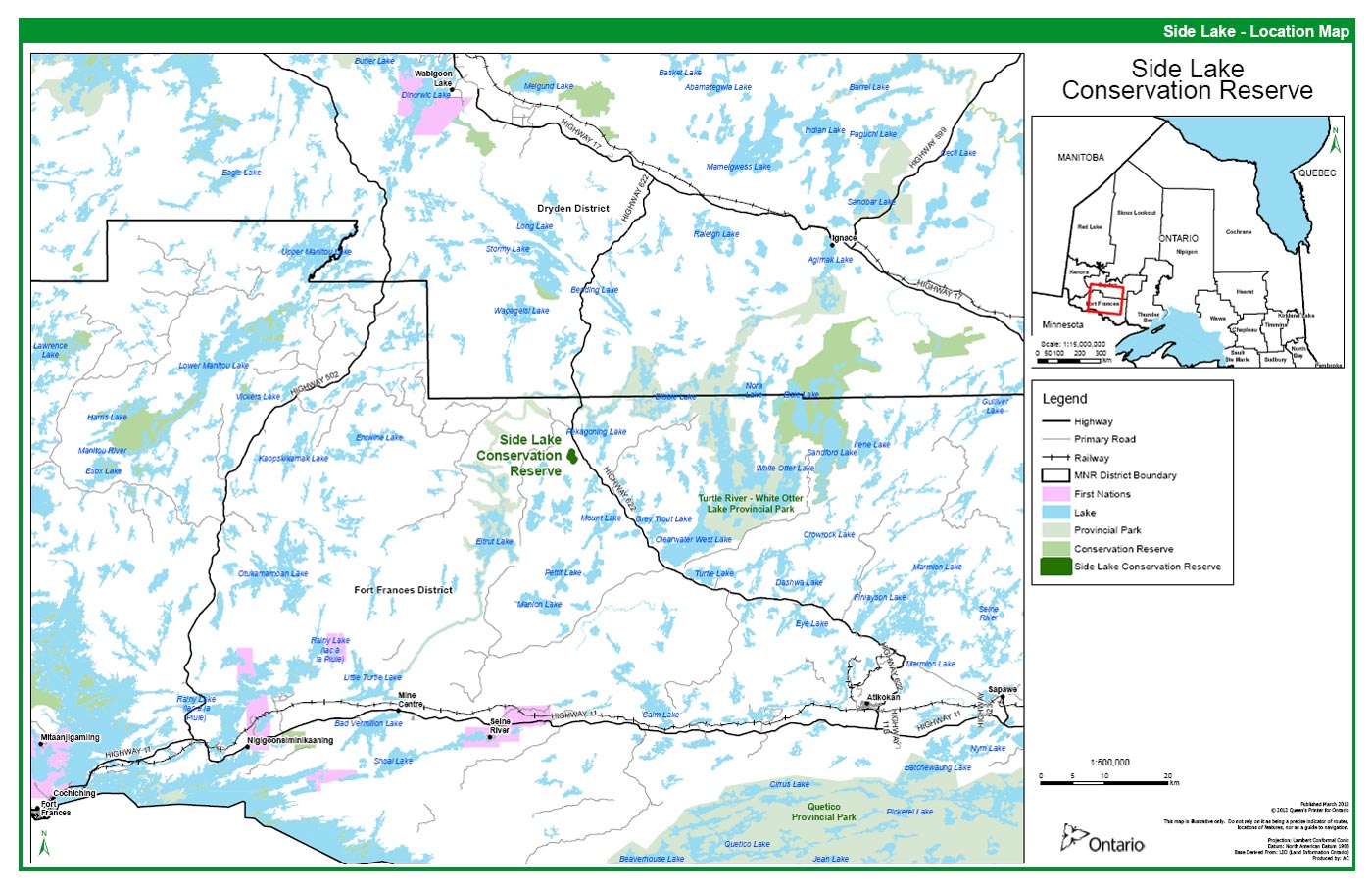
The Side Lake Conservation Reserve is a small patterned peatland located approximately 62 km northwest of the town of Atikokan, to the southeast of Side Lake and northwest of Greytrout Lake. This peatland is situated on the distal side of the Eagle-Finlayson Moraine on part of the Lake Agassiz plain, and is significant in that patterned peatlands are rarely found this far south.
2.1 Background information
| Name | Side Lake Conservation Reserve |
|---|---|
| Site Region/District | 4S-5 |
| Ecosite Class |
There are 14 ecosites located within the reserve”; ecosites ES13, ES 20, ES21, ES26, ES34, ES35, ES36, ES39, ES40, ES42, ES42,ES44, ES45 and ES49. There are also 4 classified wetland areas; W19, W18, W23 and W24. |
| Region/District/Area | Northwest / Fort Frances / Atikokan |
| Total Area (ha) | 91 |
| Regulation Date | May 21, 2003 |
| Interested First Nations | Area is within Treaty Three boundary |
| OBM | 2015 5500 54400/ 2015 5500 54300 |
| Latitude/Longitude | 49° 07' 00"/ 92° 14' 40" |
| Basemap | 55544 / 55543 |
| Forest Resource Inventory Stands | 55544; 54000, 57000, 55050, 52120, 49110, 46010, 51010, 41020, 55543, 54990, 52980, 50970, 53970, 55970 |
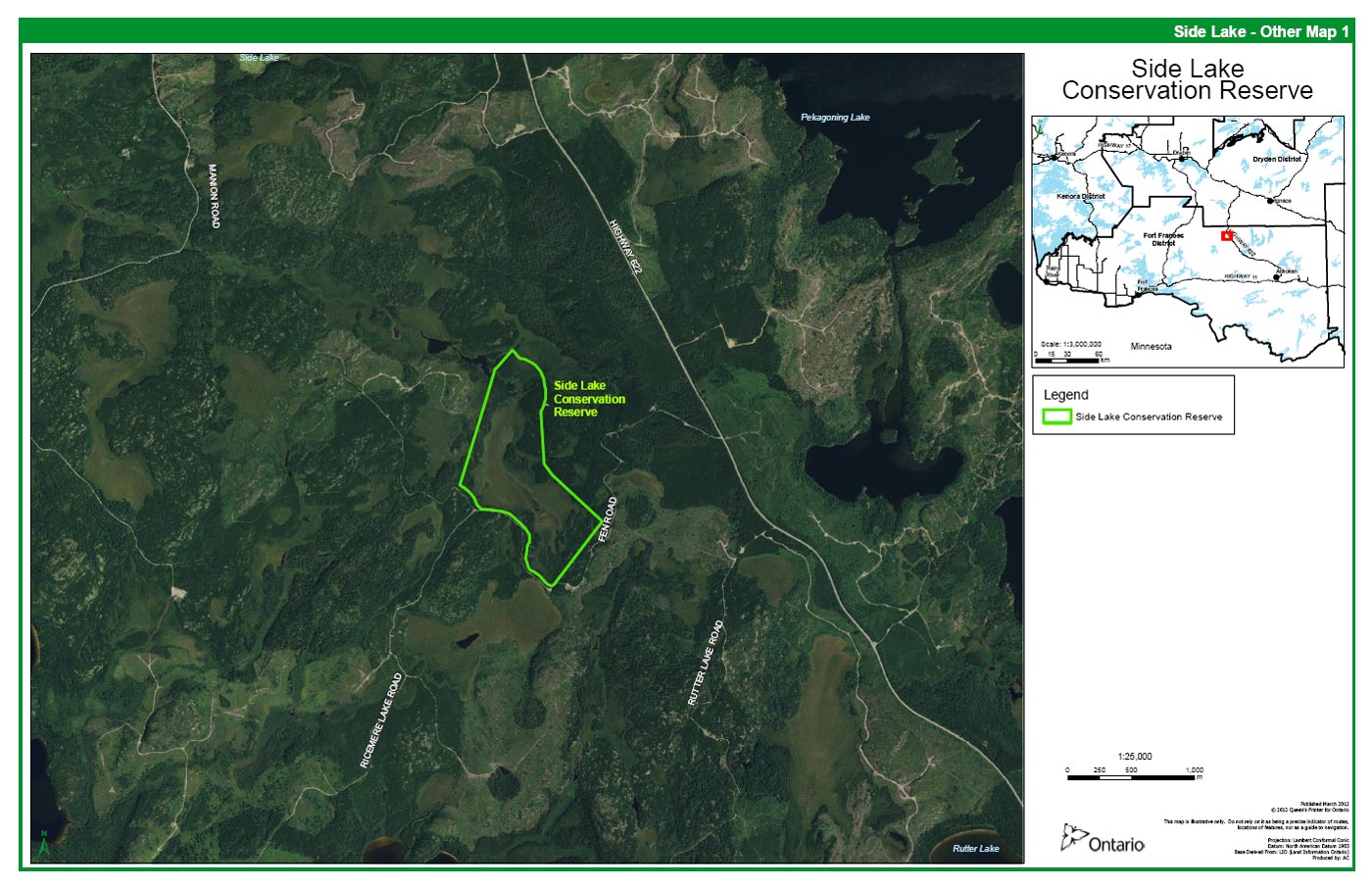
| General Location Description | The conservation reserve is located southeast of Side Lk. northwest of Greytrout Lk., approximately 62km north of Atikokan along Highway 622. |
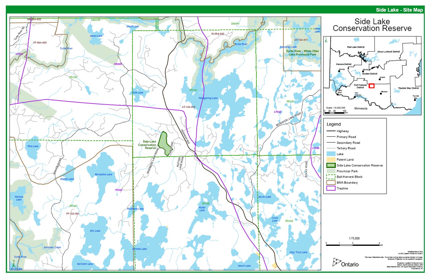
| Access | The area is accessible via the forest access road, Fen Road, off of Highway 622. It wraps along the south side of the reservation and along the west boundary and diverts to the north. There is also a forest access road that is located to the north of the reservation |
3. Representation Targets
This section provides a summary of the earth and life science system and values, cultural resources represented and recreational opportunities available or possible.
| Life Science Representation | This unique feature is an example of a provincially significant patterned peatland; with a string fen centered in the reserve and bog ecosite types, sparse forest and conifer mixed forest around the reservation borders. |
|---|---|
| Earth Science Representation | Provincially significant patterned peat bog, on weakly broken ground moraine. |
| Cultural Resource Representation | There are no documented cultural resources in the conservation reserve. |
| Recreational Opportunities | Although limited, there are hiking and hunting opportunities that exist with the reservation and may provide interest for naturalists/ecological interpretation. |
4. Survey information
This section provides an overview of the inventories completed, their level of detail and any further inventories required.
| Survey Level | Life Science | Earth Science | Cultural | Recreational |
|---|---|---|---|---|
| Reconnaissance | Completed July 21/ 2000 with further field study completed throughout the summer of 2011. | Completed July 21/ 2000 | Completed July 21/ 2000 | Completed July 21/ 2000 |
| Detailed | Not required | Not required | Not required | Completed July 21/ 2000 |
| Requirement | No further requirement | No further requirement | No further requirement | No further requirement |
5. Values to be protected
This section provides a description of the key natural heritage values on the site and their condition relative to past resource use and management activities. It also addresses the values' sensitivity to future land use and management activities.
| Life Science | Provincially significant patterned fen. Grades topographically and functionally from upland jackpine conifer, through poor black spruce swamp, treed bog, open bog, open rich fen, and meadow marsh. Note: Extremely abundant pitcher plants throughout wetland portions |
|---|---|
| Earth Science | Provincially significant patterned fen, peat bog. |
| Cultural | None Identified |
| Aboriginal | None Identified |
| Tourism | No known traditional tourism values/uses. Site is within a Bear Management Area. |
| Recreational Fishing | No lakes or fish bearing streams are present. |
| Recreational/ Commercial Hunting | Good potential access into the reserve area by foot only. Access to the site is off of the Fen Road off of highway 622, which runs along the reserve’s south west boundary and then adjacent to the reserve. Abundant moose and bear sign and heavy grouse population have been noted within and adjacent to the site. Evidence of hunting use (i.e. shell casings) have been observed in past site visits around the year 2000. Area is within Bear Management Area AT-12A-016. Harvest allocations to the west of the site have resulted in access roads becoming more accessible via motorized vehicle |
| Mining | No active claims/staking/exploration in the area. The area was withdrawn from staking under the Mining Act withdrawal Order No. W-LL-C2312/99ONT in May of 1999. |
| Aggregate | None on site. |
| Forest Harvest | No commercial values on site. The site is surrounded by old cut and the potential of area adjacent to the site being reopened to harvesting is high. Some merchantable timber is contained within the uplands surrounding the main feature, but has been removed from the production forest land base of the Sapawe Forest Sustainable Forest License. |
| Trapping | Trapline FF053 runs through the site and no overt signs of active trapping are evident within the reserve. |
| Wild Rice | No wild rice observed on site. |
| Wildlife | Abundant moose and bear sign, beaver sign, a large grouse population, and other typical woodland wildlife were observed. |
| Commercial Fisheries | None- no lakes or fish bearing streams are present. The area falls within Commercial Baitfish areas FF0184 and FF0168. |
5.1 Values to be protected
The intent of this Statement of Conservation Interest is to protect the above mentioned values by establishing management guidelines for existing and potential uses in this area, given the level of past disturbance and the nature of the existing features.
5.1.1 Forest values
The entire area covered by the site is to be protected from human disturbance as the patterned fen that is the principle feature of this site is a sensitive ecosystem.(Appendix A and Figures 2-8) The site has been found to be home to delicate flora and fauna types. Two species of dragonflies, the Zigzag darner and Muskeg darner, which are considered to be uncommon in northwestern Ontario, but widespread in bogs and fens, particularly large peatlands (D. Elder, 2012).
5.1.2 Recreational and commercial values
The site offers few recreational uses and has limited potential due to lack of traditional recreation features (i.e. lakes, rivers, etc.) Some potential exists for hunting but currently access is limited. Re-opening of the existing access road for forest harvesting operations has allowed for timber harvesting operations to the west would undoubtedly result in significant hunting activity nearby in the fall.
5.1.3 Tourism values
Limited traditional tourism use evident in or near site. The site falls within BMA AT12A-16 and appears to house a large bear and moose population. Numerous active moose trails criss-cross the wetland features. Increased hunting pressure in and around the area may be viable.
6. Management guidelines
The following topics briefly describe the existing situation followed by the guidelines to be implemented or continued.
6.1 Land tenure
The Side Lake Conservation Reserve consists entirely of Crown land. No disposition, by sale, Crown lease, or Land Use Permit, will occur within the conservation reserve.
6.2 Existing and proposed development
No development exists in the area, with the exception of old grown in logging roads that make up a portion of its boundary. This logging road is expected to be re-opened in the future, but the right-of-way lies outside the protected area. No further development will be allowed in the area such as campsites or trails within the wetland portion of the site that would disturb the delicate nature of the site. Road construction or re-construction will not be allowed in this conservation reserve.
6.3 Recreational activities
The area is suited to few recreational activities and has limited potential due to a lack of traditional recreational features. Activities such as hunting, hiking, wildlife viewing etc. are permitted to continue within the site.
6.4 Commercial activities
The site forms part of a First Nation trapline. Trapping will continue as a permitted activity. The site also falls within a Bear Management Area and a Baitfish License. These uses will be allowed to continue with the condition that no new trails or other disturbances are permitted without prior authorization. However no new activities such as road construction, aggregate removal, mineral exploration and development or construction of utility corridors will be permitted within the boundaries of the protected area.
The area will be permanently removed from the operable Sapawe Forest SFL. The area has been withdrawn from all mining exploration and extraction activities.
6.5 Aboriginal interests
There are no known First Nations concerns relating to the Side lake site. All aboriginal and treaty rights will continue in this site.
6.6 Natural Resources Stewardship
6.6.1 Vegetation management
The area will naturally evolve and should be stable for another 50-150 years.(Noble, 1995) This site contains a provincially significant patterned peatland, wildlife, native values and is surrounded by harvestable timber on the Sapawe Forest. MNR recognizes fire as an essential ecosystem process, fundamental to restoring and maintaining the ecological integrity of protected areas in the Boreal Forest Region. Fire management involves the protection of values and the attainment of resource management objectives through fire response and fire use. The Forest Fire Management Strategy for Ontario (OMNR 2004) provides strategic direction for the management of wildfire across Ontario. The Side Lake Conservation Reserve is in the Boreal Fire Management Zone according to this provincial strategy. Fire management objectives within the CR will focus on preventing personal injury, value loss and social disruption. Fires that pose a threat to public health and safety, property and infrastructure, or other values will receive a full response and sustained action. “Light on the land” fire suppression techniques will be used whenever feasible. These minimal impact suppression techniques do not unduly disturb natural or cultural values. Examples may include limiting the use of heavy equipment or the felling of trees during fire response.
6.6.2 Fish and wildlife management
Existing WMU and sport fishing regulation and management activities will apply.
6.6.3 Landforms
There are no requirements other than continued protection.
6.7 Cultural Resources Stewardship
There are no requirements at this time based on existing information.
6.8 Client services
Information about this conservation reserve will be made available to ensure that all resource users are aware of its location, its recognized values and permitted uses.
6.9 Research
Non-destructive research related to the inherent values of the site will be encouraged. The principle feature being a patterned fen may provide interest for naturalists relative to the plants communities and physiographic relationships found here.
6.10 Marketing
There are no requirements at this time.
7. Implementation
The Side Lake Conservation Reserve was regulated on May 21, 2003 under the Public Lands Act, and is now governed by the Provincial Parks and Conservation Reserves Act (2006).
8. Review and revisions:
In accordance with the Provincial Parks and Conservation Reserves Act, 2006, MNR will examine management direction documents that have been in place for 10 years or more. The next scheduled examination for the Side Lake Conservation Reserve will be in 2022. Revisions to the Side lake SCI will be subject to the requirements as specified in the Draft Class Environmental Assessment for Provincial Parks and Conservation Reserves. Significant changes will involve a public consultation process and approval from the District Manager of the Ontario Ministry of Natural Resources.
8.1 Public consultation
Side Lake has been a part of the Consultation process from early in the land use planning exercise.
- Lands For Life Round Table consultation June 97- July 98
- Ontario Forest Accord 1999
- Ontario’s Living Legacy round table discussions 1999
- OLL Site Regulation Public Consultation Process
Below find a brief synopsis of the Public and Aboriginal Consultation Documentation Form for the Side Lake Conservation Reserve.
8.2 OLL public consultation - Side Lake Conservation Reserve
- District Manager- Mailouts and newspaper adds
- Two responses concerning Side Lk.
- SFL holder had given input prior to consultation process
- Concerns - SFL holder wanted to ensure that the existing road that forms one boundary of the Site could be upgraded in the future
- Member of public raised concerns about fishing and hunting within Site
- Both issues were easily resolved
- Road is not within Site and therefore not under any restrictions
- No restrictions to hunting or fishing will apply to site
- Recommendations - Based on input no revisions were deemed necessary
(for a complete review see the Consultation Documentation Form available on file at the MNR Atikokan Area Office)
9. References
Elder, D. Personal communication regarding the rarity status of Zigzag and Muskeg darners in Northwestern Ontario. February 10, 2012.
Ontario Ministry of Natural Resources, Field guide to the forest ecosystem classification for northwestern Ontario; Second Ed. Queens Printer for Ontario, Manitoba Canada. 1997.
Ontario Ministry of Natural Resources, Ontario’s Living Legacy Land Use Strategy; Queen’s Printer for Ontario, Ontario Canada. 1999.
Ontario Ministry of Natural Resources. 2000. Protected Areas Regulation Implementation Manual; Internal Document.
Ontario Ministry of Natural Resources. 2000. Side Lake Conservation Reserve Factsheet.
Ontario Ministry of Natural Resources. 2003a. Earth Science Reconnaissance inventory report for the Side Lake Conservation Reserve. 14pp
Ontario Ministry of Natural Resources. 2003b. Life Science Reconnaissance Inventory Report for the Side Lake Conservation Reserve. 15pp
Ontario Ministry of Natural Resources. 2003c. Recreation Inventory Report for Side Lake Conservation Reserve. 10pp.
Ontario Ministry of Natural Resources. 2004. Forest Fire Management Strategy for Ontario. Queen’s Printer for Ontario, Toronto. 64 pp.
Ontario Ministry of Natural Resources. 2006a. Provincial Parks and Conservation Reserves Act. Toronto. 44pp. http://www.elaws.gov.on.ca/html/statutes/english/elaws_statutes_06p12_e.htm
Ontario Ministry of Natural Resources. 2009a Ontario Protected Areas Planning Manual. Peterborough. Queen’s Printer for Ontario. 50 pp.
Ontario Ministry of Natural Resources. 2006b. Crown Land Use Policy Atlas, policy report C2312: Side Lake.
Ontario Ministry of Natural Resources. 2011. Appendix 7-Regionally significant bird species Northern Ontario Wetland Evaluation System Manual. Draft Version
Oldham, M.J. and D.R. Elder, Noteworthy Odonata records from northwestern Ontario; Resource Guide and Annotated List, Privately Published. 2000.
Noble, T., Site District 4S5 Gap Analysis; Ontario Ministry of Natural Resources, Northwest Region, 1995.
Newmaster, S.G, A.G. Harris and L. Kershaw. 1997. Wetland plants of Ontario. Lone Pine Publishing and Queens Printer for Ontario
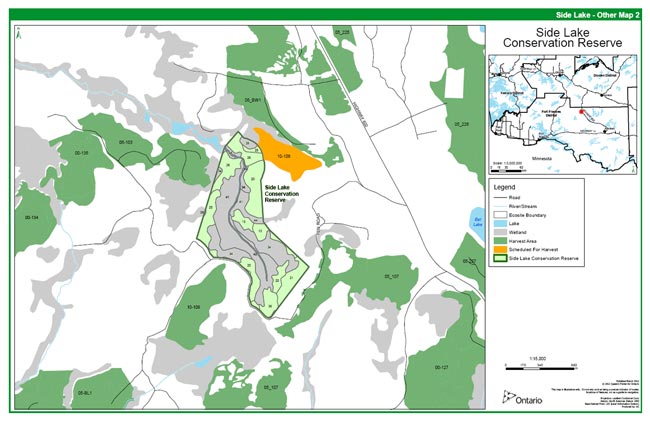
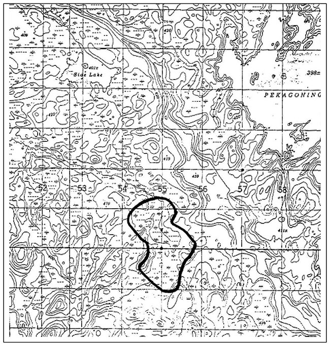
Appendix 1. Regional and site maps of Side Lake Conservation Reserve
Figure 1: Regional map of Side Lake Conservation Reserve
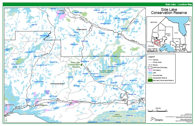
Enlarge Figure 1: Regional Map of Side Lake Conservation Reserve
Figure 2. Site map of Side Lake Conservation Reserve
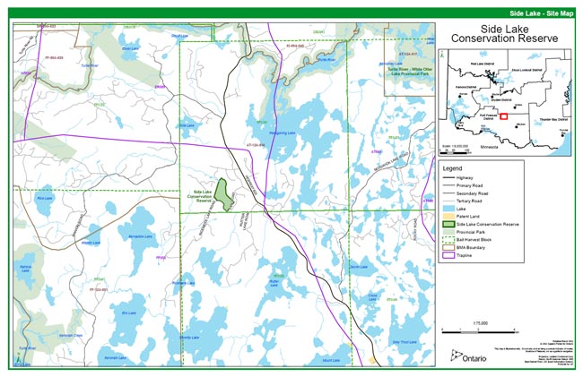
Enlarge Figure 2. Site map of Side Lake Conservation Reserve
Appendix 2
Classification Notes
Side Lake Site
Appendix A: Side Lake SCI
The following are field notes taken during a trip to Side Lake Site.
Bat Lake Fen Classification - Sept 26, 1997
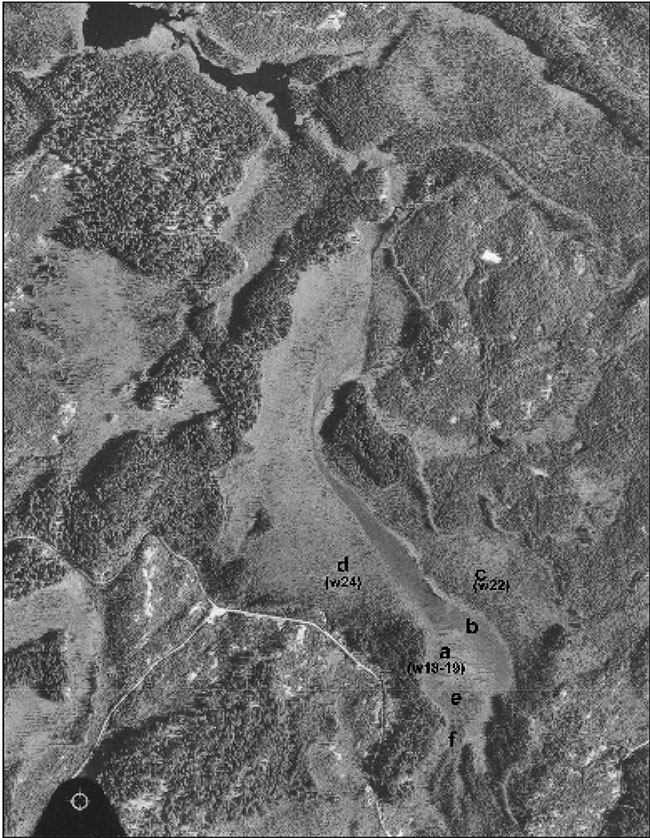
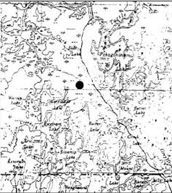
A trip was made to the fen located west of Bat Lake on Sept. 26, 1997 by Tom Nash, Paul Hosick and Brian Jackson to classify this wetland. The fen had been identified during a flight to pick candidate sites for protected areas. This site is one of the few known pattern fens in the Atikokan area at this time. The fen is located approximately 3 km northwest of Rutter Lake and is on the west side of an end moraine (Eagle/Finlayson Moraine) with water flow being west off the moraine and then north through the fen.
The field trip involved walking in to a number of sites within the wetland and classifying them following the Wetland Ecosystem Classification for Northwestern Ontario (see Harris et al. 1996). In total six sites were classified, mostly at the south end of the fen (see locations "a" to "f'"on attached photo - figure 3). The species identified and the WEC for each are provided in the attached appendix.
From the sites looked at, it appeared that the wetland was composed of fens in the water track with some raised bog areas along the edges. The main water track in the string area was made up mainly of a moderately rich graminoid fen (W19)(site b) with some area of moderately rich fen : tamarack-black spruce/ericaceous shrub (W18)(site a)). The northeast side of the main water track was a poor treed fen : black spruce-tamarack / ericaceous shrub/Sphagnum (W22) (site c). The west side of the fen was an open low shrub bog: ericaceous shrub/Sphagnum (W24) (site d).
The area of sites "e" and "f" were mostly poor treed fen : black tamarack/ericaceous shrub/Sphagnum (W22). They were, however, more diverse than site c some small areas approaching thicket swamps (with speckled alder) and small areas of raised Sphagnum with bog-like conditions and areas with more water flow appearing like site "a" (W18). At the area just north of the road (within 100 m), the area opened up into a shrub dominated site with some rich fen plant species (northern bog goldenrod, violets, brown mosses) indicating a richer site.
Species lists for plot sites
Site a
Trees/tall shrubs (2-10m)
(none)
Low shrubs
dwarf birch, tamarack, leatherleaf, bog rosemary, bog laurel, small cranberry, black spruce
Herbs
pod grass, pitcher plant, water horsetail, buckbean
Graminoids
wire sedge, livid sedge, tufted clubrush, beaked sedge
Mosses
S.warnstorfi S.wulfianum
Submergents
flat-leaved bladderwort
Site b
Trees/tall shrubs (2-10m)
(none)
Low shrubs
tamarack, leatherleaf, bog rosemary, bog laurel
Herbs
pitcher plant, buckbean,
Graminoids
wire sedge, livid sedge, tufted clubrush, Canada rush, beaked sedge
Mosses
S.wulfianum, (bristly moss)
Submergents
flat-leaved bladderwort
Site c
Trees (>10m) black spruce (few)
Trees/tall shrubs (2-10m) black spruce,
Low shrubs
dwarf birch,. leatherleaf, bog laurel, small cranberry
Herbs
creeping snowberry, pitcher plant, three-leaved Solomon’s seal
Graminoids
beaked sedge
Mosses
S.warnstorfi, S.sp?
Site d
T rees/tall shrubs (2-10m)
tamarack, black spruce
Low shrubs
tamarack, leatherleaf, bog rosemary, black spruce
Herbs
Graminoids
beaked sedges
Mosses S.sp?
Site e
Trees (>10m) black spruce (few)
Trees/tall shrubs (2-10m)
speckled alder, black spruce, tamarack
Low shrubs
speckled alder, dwarf birch, leatherleaf, bog laurel, bog rosemary, small cranberry, bog willow
Herbs
pod grass, three-leaved Solomon’s seal
Graminoids
Mosses
S.sp? (hummocks)
Site f
Trees (>10m) black spruce (few)
Trees/tall shrubs (2-10m)
black spruce, speckled alder, tamarack, willow (sp?)
Low shrubs
speckled alder, dwarf birch, leatherleaf, bog laurel, small cranberry, creeping snowberry, velvet leaf blueberry, Labrador tea, black spruce
Herbs
three-leaved Solomon’s seal, fern (dead; sp.?)
Graminoids
bluejoint grass
Mosses
S. warnstorfi, S.sp?
Area north of road (within 100 m) similar to site d but more open and with northern bog goldenrod, violets, twinflowers and brown mosses.
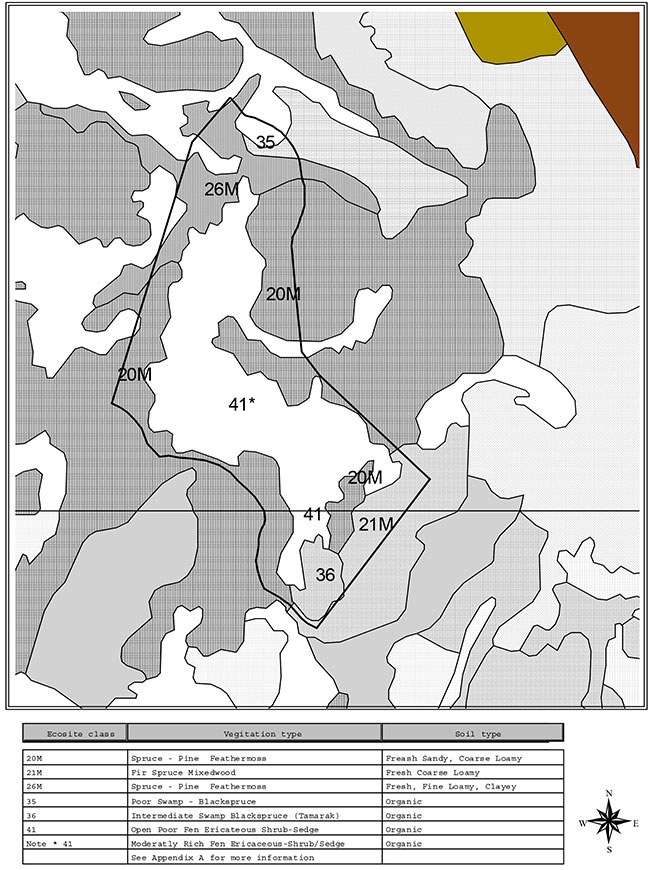
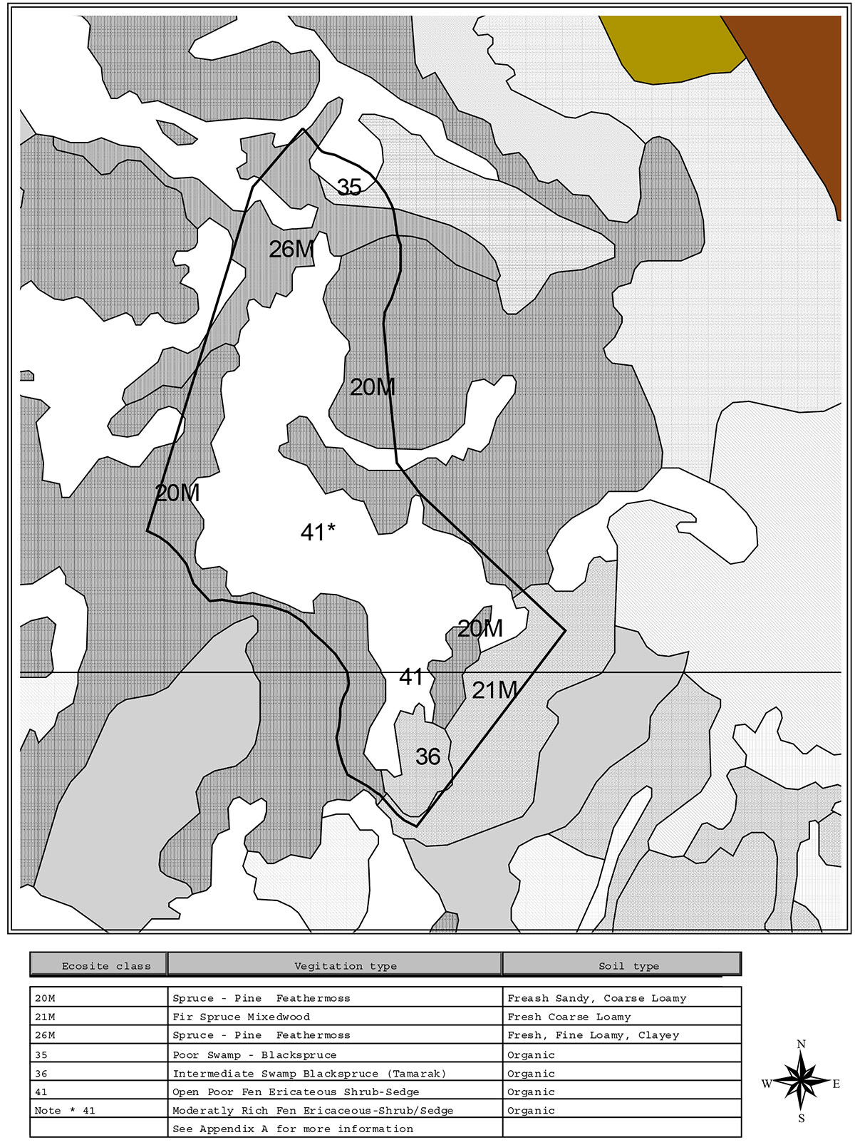
Figure 3. Ecosite Classification - Side Lake Conservation Reserve
Appendix 3
Photos of Side Lake Site
Figure 4: Treed Fen - Side Lake Conservation Reserve
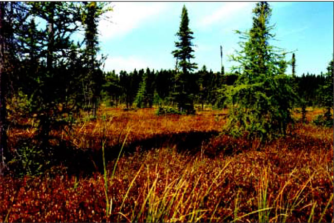
Figure 5: Graminoid Fen - Side Lake Conservation Reserve
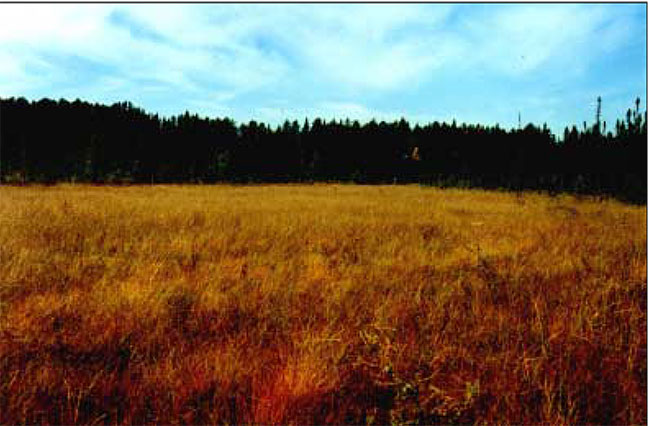
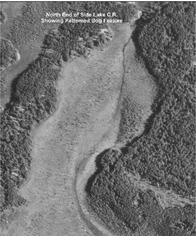
Figure 6: South End of Side Lake Conservation Reserve Showing Patterned Bog Feature
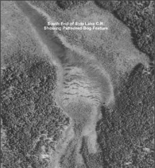
Figure 7: North End of Side Lake Conservation Reserve Showing Patterned Bog Feature
Appendix 4
Ecosite Classification Map
&
Forest Stand Map
Figure 8: Ecosite Classification - Side Lake Conservation Reserve
Enlarge Figure 8: Ecosite Classification - Side Lake Conservation Reserve
Figure 9. Forest Stand Types - Side Lake Conservation Reserve
Enlarge Figure 9. Forest Stand Types - Side Lake Conservation Reserve
Appendix 5
Figure 10. Map depicting the satellite imagery within and surrounding Side Lake Conservation Reserve

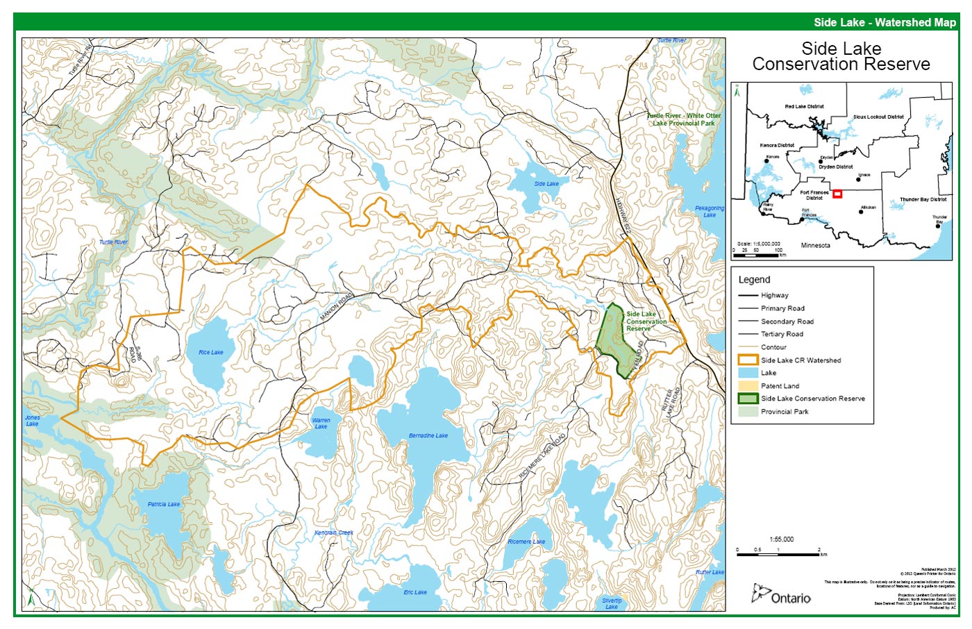
Appendix 6
Figure 11. Map depicting watershed boundary within which Side Lake Conservation Reserve is located.
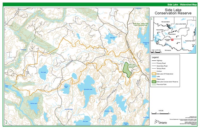
Appendix 7
Side Lake Permitted Uses List
| Activity / Value | Permitted | Not Permitted | Modified | District Manager’s Approval |
|---|---|---|---|---|
| Sport Hunting | ✔ | |||
| Commercial Trapping | ✔ | |||
| Baitfishing | ✔ | |||
| Commercial Wild Rice Harvest | N/A | |||
| Mineral Exploration and Extraction | ✔ | |||
| Land Dispositions for Private Purposes | ✔ | |||
| All Terrain Vehicle (ATV) | ✔ | |||
| Snowmobiles | ✔ | |||
| Land Claims | ✔ | |||
| Traditional Uses | ✔ | |||
| Native Hunt Camps | ✔ | |||
| Commercial Tourism Based Hunting | ✔ | |||
| Native Hunting | ✔ | |||
| Commercial Native Trapping | ✔ | |||
| Wildlife Management | ✔ | |||
| Commercial Forest Operations | ✔ | |||
| Vegetation Management (ie. Herbicides) | ✔ | |||
| Logs for Building etc. | ✔ | |||
| Fuelwood | ✔ | |||
| Insect / Disease Suppression | ✔ | |||
| Sport Fishing | N/A | |||
| Commercial Fishing | N/A | |||
| Native Fishing | ✔ | |||
| Water Control Structures | ✔ | |||
| Aggregate Extraction | ✔ | |||
| Bear Management Area’s | ✔ | |||
| Trapline Cabins | ✔ | |||
| Wild Rice Harvest (personal use/Native) | ✔ | |||
| Boat Caches | N/A | |||
| Fire Management | ✔ | |||
| Archeological Study | ✔ | |||
| Backcountry Travel | ✔ | |||
| Wildlife Viewing / Photography | ✔ | |||
| Hiking | ✔ | |||
| Rock Climbing | N/A | |||
| Mountain Biking | ✔ | |||
| Nordic Skiing / Snowshoeing | ✔ | |||
| Aircraft | N/A | |||
| Roads / Bridges / Culverts | ✔ | |||
| Ongoing Research | ✔ | |||
| New Research | ✔ |
Note: Modified means that use may be permitted under certain circumstances, where the use would not impact the values for which the Conservation Reserve was created (i.e. new trails for snowmachines or ATV's)
Appendix 8
Noble, T., Site District 4S5 Gap Analysis; Ontario Ministry of Natural Resources, Northwest Region, 1995
Life Science Checksheet
| Name: | Side Lake-Patterned Peatland |
|---|---|
| Map Number: | 52F/1 |
| UTM: | 5550 , 54400 |
| County/District: | Kenora |
| Township: | |
| Hectares: | |
| Ownership: | Crown |
| Administration: | |
| Forest Region/Section: | L11 |
| Site Region: | 4S |
| Site District: | 4S5 |
| MNR Region: | NW |
| MNR District: | FF |
| IBP: | |
| Sensitive Area: | |
| Description: | There is a small patterned peatland (ridge and swale) located southeast of Side Lake and southwest of Grey Trout Lake. This peatland is situated just in front of the Eagle-Finlayson Moraine on a part of the Lake Agassiz lake plain. This is a provincially significant feature given that patterned peatlands are uncommon this far south. The site was only seen briefly from a helicopter, however, there appeared to be graminoid fen (probably poor fen) associated with the ridge and swale water-track. Where there was a buildup of sphagnum species there appeared to be open low-shrub and treed bog. |
Figure 12. Map: Life Science Checksheet
Potential community/site type representation
| LI | L2 | L3 | Dominant | Site | SIG stand# |
|---|---|---|---|---|---|
| Bog | Open | Low-shrub | Chamaedaphne calyculata | C-O-V W | SL004 |
| Bog | Treed | Shrub-rich | Picea mariana | C-O-VW | 5L005 |
| Fen | Open | Forb | Menyanthes trifoliata | C-O-S | SL002 |
| Fen | Open | Graminoid | Carex lasiocarpa | C-O-VW | SL003 |
| Fen | Open | Graminoid | Carex oligosperma | C-O-VW | SL001 |
Biophysiographic representation
| Unit | Number | Description | Rank |
|---|---|---|---|
| Ia-27 | 5048 | M brk sandy till uplds(organic, lac sand) | P |
References: Noble, 1988
Site Significance: P
Information Level: B
Compiler: T.W. Noble
Date: Novermber 95
Figure 13. Side Lake-Pattemed Peatland 52F/1 UTM5550.54400
Appendix 9
Recreational survey
OLL recreational inventory
Employee Name: John Munroe
PA Name: Side Lake Conservation Reserve
County: N/A
Date: 21/07/2000
Local Name: C2312
Township: N/A
Part 1 – Basic recreation opportunities
| Recreation Opportunities | Permitted | Estimated number seen | Comments/details |
|---|---|---|---|
| Backcountry camping | Yes | None Tents/Parties Seen | Limited potential due to lack of traditional recreational features (i.e. lakes & rivers, etc.) |
| Canoeing | Yes | None Canoes Seen | No navigable waters (refer to Appendix D) |
| Hiking | Yes | None Hikers Seen | Limited potential due to lack of traditional recreational features (i.e. lakes & rivers, etc.) . Logging roads and skid trails adjacent to southern and eastern sides of the area afford hiking potential, but use is expected to be low. |
| Hunting | Yes | None Hunters Seen | Good potential, but primary access, by logging road off Highway 622, is currently negotiable only on foot, as the road has young (approx. 15 year-old) pine saplings blocking passage by mechanical means due to snow damage 3 - 4 years ago. Abundant moose and bear sign, and heavy grouse population observed within and adjacent to site. Evidence of past use observed (shell casings on road, vehicle tracks) Note: The 2000 - 2005 FMP has harvest allocations to the west of the site, which will mean that the main access road will need to be re-opened and rendered passable in the foreseeable future. |
| Fishing – recreational | No | None Fishing Boats Seen | No lakes or significant streams present |
| Lakes | No | None present % of Lakes Seen |
|
| Swimming opportunities | No | No lakes or significant streams present | |
| Beaches | No | None Beaches Seen | No lakes or significant streams present |
| Rapids/waterfalls | No | None Rapids/waterfalls Seen | No significant streams present |
| No significant streams present |
Other recreational/scenic features:
| Recreation Opportunities | Permitted | Estimated number seen | Comments/details |
|---|---|---|---|
| Patterned fen/topographical series | Yes | Seen 1 | The principle feature of the site, for which it was originally nominated for protection, being a patterned fen, may provide interest for naturalists relative to the plants communities and physiographic relationships inherent with this feature. The upland area included in the CR surrounding the original feature grades topographically and functionally from upland jack pine conifer (ES13), through poor black spruce swamp (ES35), treed bog (ES34), open bog (ES39), open rich fen (ES 43), and meadow marsh (ES46). Note: Extremely abundant pitcher plants throughout wetland portions, especially in main feature. |
Summary of Area Description and Land Use Intent provided in Appendix A of the Land Use Strategy, July 1999, with specific reference to recreation uses and features:
This site contains a provincially significant patterned (ridge and swale) peatland.
Additional Comments:
Primary purpose of this site is protection/representation, not recreation.
Recommendations:
No action to deliberately improve access is warranted from a recreational standpoint. Access may be improved temporarily in association with nearby logging operations. Use of existing trails (old logging roads and skidtrails permitted, but no new trails, especially within wetland portions of the site, should be permitted, as these could potentially damage the feature.
Part 2 – Human influences
| Recreation Opportunities | Permitted | Estimated number seen | Comments/details |
|---|---|---|---|
| Established campsites | No | None Size Soil Type Slope Distance to Water % Vegetation Cover |
No campsites exist within the CR, but potential sites exist in the form of old aggregate pits nearby associated with logging roads. No potable water is available nearby. |
| Established canoe routes | No | None | No significant streams present |
| Portages | No | None | |
| Established hiking trails | No | None | Logging roads and skid trails adjacent to southern and eastern sides of the area provide some hiking potential, but are rapidly revegatating |
| Snowmobile trails | No | None | Logging roads and skid trails adjacent to southern and eastern sides of the area provide some snowmachine potential, but are rapidly revegatating |
| ATV trails | No | None ATV Users Seen | Logging roads and skid trails adjacent to southern and eastern sides of the area provide some atv potential, but are rapidly revegatating |
| Existing informal access points | Yes | Access points 1 | Logging road from Highway 622, and which forms southerly boundary of the CR, provides principal access, although pine saplings blocking passage by mechanical means and general revegataion currently limit use. |
| Existing informal access points (road & parking) | No | None Access points Privy? No |
|
| Existing boat caches | No | None Boat caches | |
| Hunt camp | No | None Camps | |
| Trapping | Yes | Trappers 1 Trapline 1 |
Note: Trapline (FF53) is a Native trapline; no overt signs of active trapping within site |
| Trapper cabins | No | None Cabins | |
| Resort/lodge in park | No | None Buildings | No known traditional tourism values/use; area is included within Bear Management Area #AT-12A-16 and high black bear population is indicated by observed signs of bear activity within an adjacent to the area. No overt signs of bear hunting observed. |
| Resort/lodge adjacent to park | No | None Buildings Type of clientele |
|
| Outpost camp in park | No | None Buildings Type of clientele |
|
| Outpost camp adjacent to park | No | None Buildings Type of clientele |
Nearest outposts are on Pekagoning Lake to the east, and Mount Lake to the south |
| Historic sites/structures | No | ||
| Mining | No | ||
| Mining adjacent to park | No | ||
| Current mining exploration | No | No active claims/staking/exploration in the area | |
| Evidence of past exploration | No | None observed | |
| Inholdings | No | ||
| Transmission lines | No | ||
| Rights-of-way | No | ||
| Towers | No | ||
| Wild Rice Harvesting | No | No wild rice observed | |
| Water impoundments | No | ||
| Roads | No | Existing roads are outside/adjacent to the CR |
Other human-made structures:
| Recreation Opportunities | Permitted | Estimated number seen | Comments/details |
|---|---|---|---|
| Boulder Cairn | Yes | 1 | Pile of large, stacked boulders (cairn) observed near SW boundary adjacent to logging road - no significance - apparently backhoe operator’s serendipity Additional Comments: Area is unlikely to be subject to significant development pressures in the foreseeable future Recommendations: No action required at this time. Trail and other deveopement within protected area should be discouraged. |
Map
Figure 15. Recreational survey overview map of Side Lake Conservation Reserve
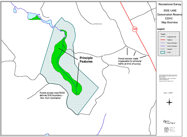
Enlarge Map: Recreational survey overview map of Side Lake Conservation Reserve