Silver Creek Peatland Conservation Reserve Management Statement
This document provides policy direction for the protection, development and management of the Silver Creek Peatland Conservation Reserve and its resources.
Statement of Conservation Interest
Approval statement
We are pleased to approve this Statement of Conservation Interest (SCI) for the proposed Silver Creek Peatland Conservation Reserve. It is one of 378 new protected areas approved through Ontario’s Living Legacy, a land use strategy aimed, in part, at completing Ontario’s system of parks and protected areas.
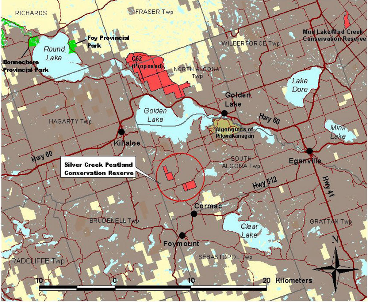
The proposed Silver Creek Peatland Conservation Reserve is located in the geographic township of South Algona, in the County of Renfrew. It is comprised of two separate parcels of Crown land, approximately 1½ km apart and totaling 281 ha. The proposed reserve includes part of the meandering Silver Creek as it passes through a broad valley, adjacent swamps and peatlands. Within the valley, the topography is gently rolling, so some areas of upland, covered in shallow till, are found within the wetlands.
The proposed conservation reserve lies within ecological Site District 5E-11 and protects the Crown land portions of the Silver Creek Provincially Significant Wetland (PSW) (20%) and the Silver Creek Peatland Area of Natural and Scientific Interest (ANSI) (33%). The Silver Creek ANSI is described by Brunton (1991), as being the largest organic deposit in the site district.
This proposed conservation reserve is situated within an area of eastern Ontario encompassed by the Algonquin Nation land claim. The Ministry of Natural Resources and the Algonquin Nation are developing a protocol to guide discussions on a number of land use matters, including implementation of Ontario’s Living Legacy Land Use Strategy.
The Silver Creek Peatland site has unique values that would benefit from protection at this time. The values at this site may be expanded in the future with the identification of other unique values through the protocol consultation process with the Algonquins. This SCI will protect the values of this site during the consultation process.
This Statement of Conservation Interest provides guidance for the management of the proposed Silver Creek Peatland Conservation Reserve and provides the basis for the ongoing monitoring of activities. More detailed direction is not anticipated at this time.
The proposed Silver Creek Peatland Conservation Reserve is managed under the jurisdiction of the Madawaska Area Supervisor, Pembroke District, Ministry of Natural Resources.
Approved by:
Ray Bonenberg
District Manager
Pembroke District
Approved by:
Ron Running
Regional Director
Southcentral Region
1.0 Introduction
The purpose of this Statement of Conservation Interest (SCI) is to identify and describe the values of the proposed Silver Creek Peatland Conservation Reserve. The SCI also outlines the activities that occur within the proposed reserve and provides guidelines for the management of current and future activities in the context of protecting the natural and cultural values.
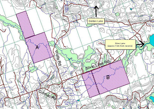
Located within the geographic township of South Algona, in the County of Renfrew, the proposed Silver Creek Peatland Conservation Reserve can be found approximately 12 km south west of the hamlet of Golden Lake and 10 km south east of Killaloe (see Figure 1). It is comprised of two separate parcels of Crown land, approximately 1½ km apart, totaling 281 ha. The northwestern parcel (Parcel A) lies to the west of Wolfe Road on Lot 30, Concession 7 and Lot 29 and 30, Concession 6. The southeast parcel (Parcel B) lies to the south of Silver Lake Rd on Lots 23, 24, 25 and 26, Concession 6 (see Figure 2).
The proposed reserve includes part of the meandering Silver Creek as it passes through a broad valley, adjacent swamps and peatlands. Floating sedge mats are confined to the watercourse (Brunton, 1991). Within the valley, the topography is gently rolling; some areas of upland, covered in shallow till, are found within the wetlands.
Lying within ecological Site District 5E-11, the proposed reserve protects the Crown land portions of the Silver Creek Provincially Significant Wetland (PSW) (20%) and the Silver Creek Peatland Area of Natural and Scientific Interest (ANSI) (33%). The Silver Creek ANSI is described by Brunton (1991), as being the largest organic deposit in the site district.
Prior to the finalization of the boundaries of the proposed Silver Creek Peatland Conservation Reserve, Pembroke District MNR staff sent out boundary consultation packages to potentially affected stakeholders (adjacent landowners, resource users, municipalities, interest groups, and organizations), inviting comment on the proposed boundaries. Boundary consultation packages were also sent out to provincial interest groups and organizations. In addition, public notices were placed in local newspapers.
There were no significant issues raised during public consultation and only four responses received.
Conservation Reserves are established by Regulation under the Public Lands Act. Statements of Conservation Interest are prepared under the authority of Procedural Guideline A – Resource Management Planning (PL Procedure 3.03.05).
1.1 Background information
| Name | Silver Creek Peatland (Proposed) Conservation Reserve |
|---|---|
| Ecological Site Region / Site District | 5E-11 |
| OMNR Administrative Region/District/Area | Southcentral Region / Pembroke District / Madawaska Area |
| Total Area (hectares) | 281 ha |
| Regulation Date | Pending |
| First Nations Interests | Algonquins |
| OBM map sheets | 10 18 3150 50400 |
| UTM Coordinates | 10 18 / 319000E/ 5041000 N (NAD 83) |
Figure 1: Location Map of Silver Creek Peatland Conservation Reserve

Enlarge Figure 1: Location Map of Silver Creek Peatland Conservation Reserve
Figure 2: Site Map of Silver Creek Peatland Conservation Reserve
Enlarge Figure 2: Site Map of Silver Creek Peatland Conservation Reserve
1.2 Representation/targets
Earth science representation:
Within Ontario’s protected areas system, the geological features of the proposed Silver Creek Peatland Conservation Reserve provide insignificant representation of the underlying alkalic felsic plutonic components of the Bancroft Terrane. The surficial geology is locally significant (Frey & Duba, 2001).
Life science representation:
The proposed Silver Creek Peatland Conservation Reserve encompasses approximately 33% of the 740 ha Silver Creek Peatland Area of Scientific and Natural Interest (ANSI). According to D. Brunton (1991), this wetland is the largest Organic Deposits landform in ecological Site District 5E-10 and neighbouring ecological Site District 5E-9 and 5E11 (Brunton, 1991).
The proposed Silver Creek Peatland Conservation Reserve is also part of a larger provincially significant wetland (PSW) It protects approximately 20% of the PSW, with the remainder bei ng privately owned (Beaudette & Tubman, 1986).
In 1987 a Species of Concern, the least bittern, was observed adjacent to the proposed reserve. More recent reports of interesting species include sedge wren (field visit 2001) and marsh wren with anecdotal reports of eastern cottontail and spruce grouse.
Cultural resources representation:
There are no known archeological sites within the proposed Silver Creek Peatland Conservation Reserve, however, the area is known to have a history of occupation spanning 5000 to 6000 years (Archaic; Early, Middle and Late Woodland; Early Historic) (Dillon Consulting, 1995). Cultural resources inventories have not been completed for this proposed conservation reserve.
Historically small portions of the proposed reserve were cleared for agriculture but are now returning to the natural state. There is evidence of small clearings, remnants of farm machinery, historical timber harvesting, and an old fence (barbed wire and cedar rail) within the proposed reserve. The date of occupation and abandonment is unknown.
1.3 Survey information
This section provides an overview of the inventories completed, their level of detail and any further inventory work required.
| Survey Level | Earth Sciences | Life Sciences | Cultural | Recreational | Other |
|---|---|---|---|---|---|
| Reconnaissance | Earth Science Checksheet- (Frey & Duba, (2001). | Life Science Check -sheet (Merchant 2002) | None known | Recreation Inventory Report (Moore, 2002) | Wetland Evaluation (Beaudette & Tubman - 1986); Life Science ANSIs in Site District 5E-10, (Brunton - 1991) |
| Detailed | no | no | no | no | no |
| Requirement | no | yes | yes | no | no |
2.0 Values to be protected
This section provides a description of the key natural heritage values of the site and their condition relative to past and present resource use and management activities. It also addresses the sensitivity of these values to future land use and management activities.
This proposed conservation reserve is located within Hills (1959) ecological Site District 5E-11. Values include earth science, life science and recreational features.
2.1 Earth science
Earth science values are focused on features (bedrock and surficial) that represent the chronology of earth history in the province (Frey & Duba, 2001).
The proposed Silver Creek Peatland Conservation Reserve is the largest peatland deposit in Site District 5E-11. Bedrock exposure is extremely scarce to absent. Geological mapping has established that the area is underlain dominantly by alkalic felsic intrusive rocks of the Bancroft Terrane in the Central Metasedimentary Belt of the Proterozoic Grenville Province.
The Bancroft Terrane is one of the five lithotectonic terranes of the Central Metasedimentary Belt of the Grenville Province As such, its representation in the proposed Silver Creek Peatland Conservation Reserve contributes to the conservation of the Grenville continental accretion theme.
The southern parcel of the proposed reserve is underlain predominantly by alkalic syenite. It was probably emplaced over an interval encompassing the waning stages of early metamorphism (circa 1290-1250 Ma). The most common rock-type is medium grained, gneissic pyroxene-albite-perthite syenite.
The bedrock geology of the northern parcel is not known because of the extensive Quaternary cover masking the underlying bedrock geology.
The surficial Quaternary glacial deposits in the area are Wisconsinan in age. The till resting on the bedrock was deposited by the continental glacial ice sheet that occupied the Brudenell and Golden Lake areas for at least 60,000 years.
Most of the other glacial deposits, including ablation till in end moraine fragments were deposited after the presence of Glacial Lake Iroquois in the Lake Ontario basin, 12,600 to 12,000 years before present (BP) and prior to the maximum northwestern extension of the Champlain Sea, about 11,000 year BP.
During deglaciation, large and small proglacial lakes formed in front of the ice margin along the Saint Patrick Fault escarpment and in the basins of Silver and Golden Lakes, among others.
The southern parcel of the proposed conservation reserve contains a variety of glacial and recent deposits, including till, shallow glaciolacustrine and bog and swamp deposits. The till forms a very thin and discontinuous cover on the Precambrian bedrock and where it is thicker, its surface is partly fluted or drumlinized. It is predominantly basal till and has typically stoney silty sand to sandy silt texture. The thicker till, is very stony and sandy. Shallow-water glaciolacustrine pebbly to silt y sand underlies more than half of the wetlands. It was deposited in the proglacial lake basin of Silver Lake, to the northeast. Recent deposits of bog and swamp occur along the drainage of Silver Creek.
The northern parcel, similarly to the southern one, is mainly glaciolacustrine pebbly to silty sand and recent swamp. A very small patch of subglacial sandy to silty and stony till is exposed in the southwest corner of the parcel.
2.2 Life science
The proposed Silver Creek Peatland Conservation Reserve is located within Hills' (1959) ecological Site District 5E-11.
Representation:
The proposed Silver Creek Conservation Reserve is comprised of two parcels of Crown land in the provincially significant Silver Creek Wetland and Silver Creek Peatland ANSI. This wetland is the largest Organic Deposits landform in ecological Site District 5E-10 and neighbouring ecological Site Districts 5E-9 and 5E11 (Brunton, 1991). Here, Silver Creek meanders through a broad valley, created by a ridge to the north and hills to the south. The river is bounded by swamps, and peatlands have developed up to the bordering hills. Floating sedge mats are confined to the watercourse (Brunton, 1991). Within the valley, the topography is gently rolling, so some areas of upland, covered in shallow till, are found within the wetlands. The two parcels of Crown land are approximately 11/2 - 2 km away from each other with a total area of 281 ha.
In the northern parcel, over half of the area is covered with treed swamps, with overstories comprised of white cedar, black ash, balsam poplar, tamarack, red maple, black spruce and balsam fir (Forest Resource Inventory (FRI), 1978; Beaudette & Tubman, 1986). These ecosites, as classified by the Forest Ecosystem Classification for Central Ontario (Chambers, et al, 1997), are ES34 (White Cedar-Lowland Hardwood) and ES35 (Lowland Hardwood). Small areas of spruce- tamarack bog are the less diverse ES32 (White Cedar-Black Spruce-Tamarack). The rest is mainly shrub bogs, with alder, willow, leatherleaf, labrador tea, sphagnum moss, and scattered black spruce and tamarack (Beaudette & Tubman, 1986).
In the southern parcel, it appears that beaver flooding has caused extensive changes since the wetland study was carried out. Areas identified by the FRI (MNR, 1978) as white cedar with black spruce and/or tamarack are now alder thicket swamps with standing dead trees. A rich black ash swamp (Ecosite 35) on the western side also has many standing dead trees, and now includes marshy areas and willow alder swamp. This area grades from organic to moist mineral soil, and then into upland forest of white cedar, poplar, basswood, balsam fir and white birch. Areas closer to the river have developed marsh ecosites, including cattail, spike rush and narrow-leafed sedge organic marshes.
Most of the upland is private property, but small areas of abandoned agricultural land are within the boundaries of the southern parcel. These are a mix of woodland and field. A narrow transition zone between these fields and the wetlands support white elm, black ash, white cedar, white spruce and balsam poplar.
While the proposed Silver Creek Peatland Conservation Reserve provides good representation of the above described communities, the parcel was originally identified for protection area regulation due to its significant wetland values, not on the basis of life science representation.
Condition:
Most of the proposed reserve shows little human disturbance. The northern parcel is difficult to access. In the small areas of abandoned farmland of the southern parcel there are stone piles, open fields, trails, and a number of introduced species such as comfrey. In the black ash swamp, and in the transition zone between swamp and upland, large black ash and white cedar have been cut, and tall shrubs and young black ash are now the dominant vegetation. Changes caused by the beaver flooding appear to be still in progress.
Diversity:
This proposed conservation reserve is of moderate diversity compared to other areas. The Silver Creek Wetland Report (Beaudette & Tubman, 1986) identified five bog and eight swamp communities within the proposed reserve’s boundaries. These range from poor shrub bogs to rich black ash swamps. The changes in water level in the southern parcel have caused major changes in some of these wetland communities, and added to the diversity of the proposed reserve. The field reconnaissance of July 2002 showed the presence of at least three marsh communities. Diversity appears to be highest along the watercourse, where many small swamp ecosites are interspersed.
The assessment of diversity is somewhat lowered by the unevenness of ecosite size and dispersion. Most of the ecosites are extensive areas of bog, treed coniferous bog, treed coniferous/mixed swamp, and thicket swamp, with small areas of the rest of the ecosites.
The upland meadows supply an abundance of food for wildlife, as evidenced by the numerous species of birds and insects. Vegetation in these fields includes choke cherry, pin cherry, strawberry, raspberry, currants, serviceberry, honeysuckle, and high-bush cranberry; grasses and vetch; and scattered poplar, white pine, white spruce, white cedar and red pine.
Ecological considerations:
The southern parcel has a gravel road as its northern boundary, providing a good view over the wetland and adding aesthetic value to the proposed reserve. It also provides easy access, as the northern parcel is less accessible.
Surrounding agricultural land use is not intensive, and should be of minimal concern.
Special features:
The proposed reserve represents the largest area of organic deposits in the ecological Site District. As well, it provides habitat for least bittern, marsh wren, and sedge wren.
Significance:
The proposed reserve is completely encompassed by a provincially significant wetland and a life science ANSI. Treed swamps (black ash and cedar), shrub bog and treed bog are well represented here.
2.3 Recreational values
The unique habitat and abundance of wildlife and flora of the proposed Silver Creek Peatland Conservation Reserve make it a current destination of local naturalists.
Canoeing opportunities may occur in both parcels; a total of approximately 5 km of navigable stream exists within the proposed reserve. There are fishing opportunities as well.
Although deer, waterfowl and small game hunting takes place on private property adjacent to the proposed reserve boundary, hunting pressure within the proposed Silver Creek Peatland Conservation Reserve is considered low due to the lack of access and the boggy terrain.
The proposed conservation reserve can be accessed in the winter using the frozen Silver Creek as a route for entry via snowmobile, snowshoe or cross-country ski, however it is unlikely that local residents are doing so at the present time.
3.0 Management guidelines
3.1 Land tenure
Background:
The proposed Silver Creek Peatland Conservation Reserve is a 281 ha area comprised of two separate parcels of Crown land. As part of the Brudenell Creek watershed (2KC-9), it lies within the greater Ottawa Valley Drainage Basin.
The proposed reserve protects the Crown land portion of the Silver Creek Provincially Significant Wetland (PSW) and the Silver Creek Peatland Area of Natural and Scientific Interest (ANSI). The majority of the PSW and the ANSI, lies upon private property; the proposed conservation reserve represents 20% and 33% respectively.
The unopened road allowances within the property are municipally owned and are not considered part of the proposed reserve.
There are currently no land use permits (LUPs) associated with this site, however, Crown land fur harvesting occurs and the proposed conservation reserve is also part of a commercial baitfish harvesting zone and a Bear Management Area (BMA).
There were no significant issues raised during public consultation; one response was received in which an adjacent landowner expressed an interest in selling a portion of his land abutting the proposed reserve.
Guideline:
Sale of Crown lands within the proposed conservation reserve is not permitted, with the exception of some types of minor dispositions in support of existing uses (e.g., Land Use Permits or Licenses of Occupation). Renewals of existing land use permits are permitted. New leases or land use permits will be allowed for approved activities (see Appendix 1).
Leasing of Crown lands to new commercial outfitting services, outpost camps, resort or lodges can be considered during future planning, however, leasing of Crown lands within the proposed conservation reserve for the development of private camps is not permitted. Currently, there are no "remote" based tourism lodges or camps on Crown land with exclusive tenure to an area in Pembroke District. There are numerous lodges, resorts, motels and cottages on private land which house tourists who use nearby Crown land and lakes for recreation activities (Yaraskavitch, ca 1997-98).
Lands that would enhance the proposed conservation reserve by incorporating more of the provincially significant wetland, or by providing more public access to the site, may be purchased if funding and/or contributing partners become available. Should the municipality be willing, the acquisition by the Crown of the unopened municipal road allowances within the proposed reserve would benefit the consolidation and long term protected area management of this property.
Unauthorized occupations of lands within the proposed conservation reserve will be handled in accordance with approved policy, and any required structural removal will be undertaken at the owner’s expense.
3.2 Existing/proposed development
Background:
There is currently no known development on the site and no intention at this time to improve site development (facilities, access, and trails). The bog/peatland ecosystems have many fragile elements, such as sphagnum mounds, orchid "fields", delicate understorey vegetation, and water pools, which are very susceptible to damage by vehicles and even foot traffic.
Access to either parcel is limited to canoeing Silver Creek or by foot from municipal road frontage (Wolfe Road or Silver Lake Road). No trails are known to exist within the proposed reserve. The proposed conservation reserve is surrounded entirely by private lands.
Guideline:
Due to the unique nature of the bog/peatland in this ecological Site District, protection of these fragile elements should be of primary importance in management planning.
New trails are discouraged; however they may be considered when compatible with other recreational uses, the maintenance of environmental integrity, and the requirements of Procedural Guideline B – Test of Compatibility (Appendix 1). Any new trails will be designed to avoid those areas identified as sensitive to disturbance, or supporting provincially, regionally, or locally important plant species.
Facility infrastructure and development for recreational and/or educational purposes may be considered in the future if there is a demonstrated demand for such facilities. A more detailed management plan would be required at that time.
All provincial policies that guide development (i.e. water hazard management, wetlands) are applicable in conservation reserves as on Crown land.
3.3 Recreational activities
Background:
The proposed Silver Creek Peatland Conservation Reserve is currently the destination of local naturalists for activities such as bird-watching, natural heritage appreciation and wildlife viewing. Due to the fact that there is limited access and that there are no existing trails throughout the proposed reserve, the majority of this activity takes place on the south side of Silver Lake Road (Parcel B). Some of the majestic values of the marsh may be viewed from Silver Lake Road. The limited access and the boggy terrain keep the activity of exploring limited to the most ambitious of nature lover.
The watercourse of Silver Creek meanders through the proposed reserve (approximately 1.75 km of stream within Parcel A and approximately 3 km of stream within Parcel B). The open water of Silver Lake is located approximately 5.5 km downstream from Parcel B. The portions of Silver Creek within the proposed reserve are navigable only by canoe or small motor-craft and are accessible via points along the municipal roadway.
Numerous fish species within the Silver Creek system including northern pike, bass and pumpkinseed, provide fishing opportunities. Anecdotal reports of brook trout also exist for the Silver Creek system.
Deer hunting is known to take place on private property adjacent to the proposed reserve boundary and waterfowl and small game hunting are most likely occurring as well. Although the proposed reserve itself supports the appropriate species and offers the potential for hunting, pressure within the proposed Silver Creek Peatland Conservation Reserve is considered low due to the boggy terrain and lack of access.
Access to the proposed conservation reserve is expanded in the winter to some extent. It is possible to use the frozen Silver Creek as an entry point for local snowmobiling, snowshoeing or cross country skiing however the extent of use is unknown. It should be noted that snowmobiling is becoming an increasingly popular winter activity in the Ottawa Valley and potential opportunities to enjoy this non-consumptive recreation activity may exist.
Guideline :
Most recreational activities that have traditionally been enjoyed in this area can continue provided they do not negatively impact the natural ecosystems and features needing protection. Permitted uses include such things as wildlife viewing, hiking, hunting, snowshoeing, cross-country skiing, exploring and fishing. Activities such as snowmobiling and the use of all-terrain vehicles (ATV's) will be permitted only on existing roads and trails where they do not adversely affect the values being protected. Off-trail mechanized travel is permitted only for the direct retrieval of game.
3.4 Commercial activities
Background:
Crown land fur harvesting occurs within the site and the proposed conservation reserve is also part of a commercial baitfish harvesting zone and a Bear Management Area (BMA).
Guideline:
Some commercial uses (such as commercial fishing and fur harvesting) may be permitted in conservation reserves provided they do not impact the natural heritage values for which the area is established. Existing bait fishing use and Crown land fur harvesting are permitted to continue within the site unless there are demonstrated conflicts. New baitfish and fur harvesting operations can be considered subject to the requirements of Procedural Guideline B – Test of Compatibility (Appendix 1). No new fur harvesting cabins are permitted. New authorized non-resident bear hunting operations are not permitted, however new outpost camps, resorts, outfitting services or commercial food harvesting operations may be considered within the proposed reserve.
Other new commercial activities must meet the requirements of Procedural Guideline B – Test of Compatibility, (Appendix 1). New transmission lines (e.g. power or communications), pipelines, and road corridors are discouraged through existing planning processes.
Mineral exploration and mining are not permitted within the proposed Silver Creek Peatland Conservation Reserve.
Conservation Reserves do not permit commercial forest harvesting, hydroelectric power development, the extraction of aggregate, peat, soils, or other industrial uses. (Public Lands Act, Ontario Regulation 805/94). Other new commercial activities must meet the requirements of Procedural Guideline B – Test of Compatibility
3.5 Aboriginal interests
Background:
The proposed conservation reserve is located within the land claim area of the Algonquin Nation.
There are no known archeological sites within the proposed Silver Creek Peatland Conservation Reserve, however, the area is known to have a history of occupation spanning 5000 to 6000 years (Archaic; Early, Middle and Late Woodland; Early Historic) (Dillon Consulting, 1995).
Since water courses provided food and transportation for native populations, the most reliable assessment of archeological potential is based on proximity to water (Dillon, 1995). With this in mind, it could be surmised that Silver Creek and the associated uplands might have been utilized for human occupation and exploitation.
Guideline:
The Ministry of Natural Resources and the Algonquin Nation are developing a protocol to guide discussions on a number of land use matters, including implementation of the Ontario’s Living Legacy Land Use Strategy. The Silver Creek Peatland site has unique values that would benefit from protection at this time. The values at this site may be expanded in the future with the identification of other unique values through the protocol consultation process with the Algonquins. Hunting and fishing are permitted uses in proposed conservation reserves.
3.6 Natural Resource Stewardship
3.6.1 General
This proposed conservation reserve will be managed with an emphasis on ensuring that the natural ecosystems and processes of the proposed conservation reserve are not negatively affected by current and future activities. Therefore, applications for specific uses will be carefully studied and reviewed. The Ministry, partner organizations, and/or the proponents may undertake such studies.
3.6.2 Vegetation management and fire management
Background:
Much of the proposed Silver Creek Peatland Conservation Reserve is covered in bog forest while the remainder is dominated by open, relatively dry shrub-rich bog. An evaluation of the FRI information finds that 70% of the proposed reserve is considered productive forest with the remainder being; open muskeg (19%), treed muskeg (8%), and brush/alder (3%). The meandering Silver Creek crosses the proposed reserve with open pools or floating bog mats confined closely to the watercourse (D. Brunton, 1991).
Over half of the northern parcel (A) is covered with treed swamps, with the remainder shrub bogs (Beaudette & Tubman, 1986).
In the southern Parcel (B), recent beaver flooding has caused extensive changes. Many areas that were once treed swamps are now thicket swamps with standing dead trees. Marsh ecosites are developing in areas closer to the river. On the west side, the area grades from organic to moist mineral soil, and then into upland forest. As well, small areas of abandoned agricultural land are within the boundaries of Parcel B. These areas are now a mix of woodland and field.
Guideline:
The proposed conservation reserve will be managed by allowing natural ecosystems, processes and features to operate normally, with minimal human interference or alteration.
Conservation reserve policy states that forest fire protection will be carried out in the proposed reserve as on surrounding public lands, unless it is determined through management planning that another approach should be undertaken. Pembroke District MNR has a policy of aggressively suppressing all fires. The MNR would appropriately respond to any fire as per policy or municipal agreements at any such time, with a "light on the land" approach (i.e., no bulldozers, no camp construction, minimal cutting).
Programs may be developed to control forest insects and diseases in the proposed conservation reserve where these threaten significant natural heritage, aesthetic, or economic values. Where control is desirable, it will be directed as narrowly as possible to the specific insect or disease. The methods selected will be subject to the requirements of Procedural Guideline B – Test of Compatibility (Appendix 1).
Any habitat alterations would be reviewed on a case by case basis, with consideration given to the protection of natural heritage values, OMNR's environmental assessment responsibilities and provincial Conservation Reserve policy.
Invasive species which are deemed to threaten the natural heritage values of the proposed conservation reserve will be managed using acceptable and approved controls which protect natural heritage values and are subject to Procedural Guideline B – Test of Compatibility (Appendix 1).
The Ministry of Natural Resources will continue to work with municipalities and private landowners to protect private land portions of the provincially significant wetland by way of land tax incentives, co-stewardship opportunities and through municipal land use planning. Landowners with property in a provincially significant wetland may be eligible for the Conservation Land Tax Incentive Program, providing they meet the program criteria and agree to protect the natural heritage values of their property. Protection of the wetland can also be promoted by municipal consideration of the Provincial Policy Statement and Planning Act within planning documents and through development review.
3.6.3 Fish and wildlife management
Background:
Silver Creek supports warm-water fish species such as northern pike, large and small-mouth bass, pumpkinseed and many species of forage fish. There are also anecdotal reports of brook trout within the Silver Creek system.
In 1987 a Species of Concern, the least bittern, was seen on the north side of Silver Lake Road. Although sighted just outside of the proposed reserve, the bittern was utilizing the Silver Creek wetland complex.
Other interesting species noted include; sedge wren (field visit 2001) and reports of eastern cottontail and spruce grouse, which may warrant further field investigation.
Marsh wren, northern harrier and Virginia rail were all observed during the completion of the wetland evaluation in 1986 as were snowshoe hare and ruffed grouse.
The abundance of aquatic flora and fauna available for viewing along Silver Creek Road may offer the greatest recreation potential within the proposed reserve. Although hunting is popular within Pembroke District and the proposed reserve supports many desirable species, there is a lack of good access and maneuverability within the proposed reserve. This inac cessibility inhibits an enjoyable hunting experience.
Guideline:
Activities such as nature appreciation, photography and wildlife viewing are all permitted uses.
Fisheries management within the proposed reserve will be guided by the fishing regulations associated with Division 15 of the Central Ontario Region.
The management of game and fur species in the proposed conservation reserve will continue to be consistent with the wildlife management unit (WMU 59) within which it lies.
Hunting within the proposed conservation reserve may continue and will be guided by the relevant Ontario hunting regulations. Although bait-fish harvesting and Crown land fur harvesting currently exist in the proposed reserve, new bait-fish harvesting operations and commercial fur harvesting operations could be considered if necessary, subject to the requirements of Procedural Guideline B – Test of Compatibility (Appendix 1). Fur harvesting and bait-fishing would be managed through the current licencing system.
Any habitat alterations would be reviewed on a case by case basis, with consideration given to protection of natural heritage values, OMNR's environmental assessment responsibilities and provincial conservation reserve policy.
Invasive species which are deemed to threaten the natural heritage values of the proposed conservation reserve will be managed using acceptable and approved controls which protect natural heritage values while being subject to Procedural Guideline B – Test of Compatibility (Appendix 1).
3.7 Cultural Resource Stewardship
Background:
The protection and conservation of cultural heritage resources is governed by the Ontario Heritage Act and administered by the Ministry of Citizenship, Culture and Recreation. Cultural features (e.g., abandoned homestead) have been identified on site while archeological and historic values have been identified in the area.
Guideline:
Interested partners with the appropriate qualifications would be allowed to undertake inventories and studies of the area, consistent with Procedural Guideline C - Research Activities in Conservation Reserves (Appendix 2). The specific location of cultural heritage sites will be kept confidential to protect the resources.
3.8 Client services
Background:
Client services (such as interpretation, access and signage) associated with the site are limited to a brief informative fact sheet that was developed during the public consultation phase in 1999. No services or facilities are presently provided within the site boundaries. The fact sheet for the proposed Silver Creek Peatland Conservation Reserve is currently available to the public through the Pembroke District office or via the internet at: www.ontarioslivinglegacy.com. (Link no longer active)
Guideline:
Given the focus on low key management, client information will be given on an inquiry basis only and will deal with the basic level of information with respect to access, natural heritage appreciation, recommended activities, and boundaries.
3.9 Research
Background:
Beaudette & Tubman completed a wetland evaluation of the Silver Creek Wetland in 1986. It was found that this wetland ranked as Provincially Significant within Ontario. As well, D.F. Brunton completed a report on Life Science ANSI's in Site District 5E-10 in 1991.
As part of the responsibilities associated with the regulation of the proposed reserve, three additional reports were completed and can be found on file with the Ministry of Natural Resources at the Pembroke District office. They are as follows:
- Natural Heritage Area – Life Science Checksheet (Merchant, 2002)
- Recreation Resource Inventory Report (Moore, 2002); and
- Earth Science Report (Frey & Duba, 2001)
Guideline:
A detailed bedrock and surficial geological inventory of the proposed Silver Creek Peatland Conservation Reserve is not warranted because of its small size and absence of bedrock outcrop. The wetlands however are sensitive to significant lowering of water levels through unplanned human disturbances. Such activity would damage the wetland ecosystem but have no effect on the underlying bedrock (Frey & Duba, 2001).
Cultural/historical inventories should be conducted within the site in order to determine the extent of Native archeological features.
In general, non-destructive research by qualified individuals will be encouraged to:
- provide a better understanding of the natural values protected by the proposed Silver Creek Peatland Conservation Reserve
- monitor impacts of recreational use of the site; and
- advance protection, planning and management of the proposed conservation reserve
Research proposals and activities must follow Procedural Guideline C – Research Activities in Conservation Reserves (PL. Procedure 3.03.05) (Appendix 2).
All research programs will require the approval of the Ministry of Natural Resources as will the removal of any natural or cultural specimen. The establishment of permanent plots, observation points or facilities must also be approved and be compatible with the proposed conservation reserve protection objective. Any site disturbed by research activities must be rehabilitated as closely as possible to its previous state. The researcher will submit copies of reports, publications, theses and results to the OMNR Madawaska Area Supervisor in Pembroke District.
3.10 Marketing
Background:
There has been no direct marketing of the proposed Silver Creek Peatland Conservation Reserve to date. Promotion and information about this site has been distributed primarily through the Ontario’s Living Legacy planning process. This includes recent public consultation regarding the proposed regulation and boundary refinement of the site and through the Living Legacy website at www.ontarioslivinglegacy.com.(Link no longer active)
Guideline:
Although potential may exist for additional eco-tourism opportunities, intensive marketing activity to increase recreational use of the proposed Silver Creek Peatland Conservation Reserve is neither desired nor required at this time. The fact sheets concerning this proposed conservation reserve will continue to be available to inform the public about the special values of this area and its role in Ontario’s protected areas system.
4.0 Implementation
Administrative responsibility for the proposed Silver Creek Peatland Conservation Reserve lies with the Madawaska Area, Pembroke District office of the Ministry of Natural Resources.
The Ministry will continue with the custodial care of the proposed conservation reserve and will also seek out partnerships where appropriate. Implementation of this Statement of Conservation Interest will primarily involve monitoring activities to ensure adherence to the management guidelines.
Implementation priorities include:
- consultation with Algonquin First Nation representatives and communities, as a basis of proceeding with final boundary refinement and regulation of this proposed conservation reserve
- updating this SCI upon final regulation as a conservation reserve
- undertaking additional life science, recreational and cultural/historical inventories and research and to monitor impacts of use
- examining the potential opportunities of acquiring additional lands adjacent to or in close proximity of the proposed reserve
- examining the potential to work with adjacent landowners through the local stewardship council and other partners to protect and enhance marsh wetland communities for staging and breeding waterfowl
- providing client services (e.g. brochure or fact sheet) at nearby OMNR Offices
- proceeding with minor development (e.g., signage, etc..) as funding permits; and
- ongoing education of resource users with respect to resource and land stewardship values (e.g., brochures, working with adjacent landowners, municipalities, etc.) in order to provide long term recreational opportunities and maintain the ecological integrity of the site
5.0 Review and revision of the Statement of Conservation Interest
The proposed Silver Creek Peatland Conservation Reserve’s Statement of Conservation Interest will be reviewed on an ongoing basis.
If changes are required in the Statement of Conservation Interest, they will occur through a standard process of minor and major amendments. Minor amendments will be processed in a relatively informal manner and will require the approval of the Area Supervisor. These amendments will deal with uses and activities that do not affect any of the policies in this SCI, such as new uses and/or activities that are consistent with existing uses.
Uses and/or activities that were not anticipated in the approved SCI and which have the potential to have a negative impact on the values of this proposed conservation reserve will require a major amendment. This will include an opportunity for public comment and input, and will require the approval of the District Manager and Regional Director.
References
Beaudette, Sheila, Kim Tubman. 1986. Wetland Evaluation and Data Record– Silver Creek Wetland (#7). OMNR. 22pgs + maps.
Brunton, D.F. 1991. Life Science Areas of Natural and Scientific Interest in Site District 5-10: A Review and Assessment of Significant Natural Areas in Site District 5-10. Ontario Ministry of Natural Resources.
Chambers, Brenda, Karen Legasy and Cathy V. Bentley. 1996. Forest Plants of Central Ontario, Lone Pine and Queen’s Printer for Ontario.
Davidson R. J. 1981. A Framework for the Conservation of Ontario’s Earth Science Features. Ontario Ministry of Natural Resources, Toronto.
Dillon Consulting Limited. March 7, 1995. Final Technical Reports: Highway 17 Environmental Assessment—Haley Station to Meath Hill—Environmental Assessment and Route Planning Study.
Frey, Edward and Daria Duba. 2001. Earth Science Report – C61 Silver Creek Peatland.
Hills, G. A. 1959. A Ready Reference to the Description of the Land of Ontario and its Productivity. Ontario Department of Lands and Forests, Division of Research, Maple, Ontario.
Merchant, Barb. February, 2002. Natural Heritage Area- Life Science Checksheet, Proposed Silver Creek Peatland Conservation Reserve.
Moore, T. March, 2002. Recreation Resource Inventory Report: Silver Creek Peatland Conservation Reserve (C61), OMNR.
Noble T. W. 1983. Biophysiographic Analysis of Site Region 5E. Central (Algonquin) Region, Ontario Ministry of Natural Resources.
Ontario Ministry of Natural Resources. 1987. Forest Resource Inventory Mapping (FRI) – Pembroke District.
Ontario Ministry of Natural Resources. February, 2002. Natural Resources Values Information System (NRVIS), Pembroke District.
Ontario Ministry of Natural Resources. July 1999. Ontario’s Living Legacy Land Use Strategy. Queens Printer for Ontario.
Ontario Ministry of Natural Resources. 1983. Pembroke District Land Use Guidelines. Pembroke District, Algonquin Region, Ontario Ministry of Natural Resources.
Ontario Ministry of Natural Resources. July 2001. Silver Creek Peatland Conservation Reserve (C61) Fact Sheet.
Yaraskavitch, Joe. District Evaluation of Options-Proposed Natural Heritage Areas, March 11, 1998a.
Appendix 1
Procedural Guideline B – Land Uses – Test of Compatibility (PL Procedure 3.03.05)
The Conservation Reserve policy provides broad direction with regard to the permitted uses. The policy provides only an indication of the variety of uses that will be considered acceptable in Conservation Reserves. The only caution is that "any new uses, and commercial activities associated with them, will be considere d on a case by case basis, and, they must pass a test of compatibility to be acceptable."
What does a 'test of compatibility' mean? An examination of this must start from the premise of why an area is set aside – specifically, its representative natural heritage values. Criteria are then identified to guide compatibility considerations. These criteria apply to the long-term acceptability of both existing uses and new uses.
- Conformity to SCI/RMP:SCI describes values for which an area has been set aside and the range of appropriate uses that will be permitted in the area. SCI may also speak to the acceptability of other 'new' uses currently not occurring in the The first 'test' is: "do proposed new land uses and/or commercial activities conform to the direction of the SCI/RMP for the Conservation Reserve? Would the new use(s) depart from the spirit of appropriate indicator land uses in the SCI/RMP?"
- Impact Assessment: If the proposed use(s) pass test 1 it is important to determine their impact on the area before they are approved. This should include the following:
- Impact on natural heritage values: "will the new use(s) impact any natural values in the area? If so how and to what degree? Is it tolerable?"
- Impact on cultural values: "will the new use(s) impact an historical or archaeological values in the area?"
- Impact on research activities: "will the new use(s) affect research activities in the area?"
- Impact on current uses: "will the new use(s) have any negative impact on the array of current uses?"
- Impact on area administration: "will the new use(s) increase administrative costs and/or complexity?" (For example, the cost of area monitoring, security and enforcement).
- Impact on accommodating the use outside the Conservation Reserve: "Could the use(s) be accommodated as well or better outside the Conservation Reserve?"
- Impact on socio-economics of the area: "will the new use(s) affect the community (ies) surrounding the area in a positive or negative way?" (For example, will the new use make an area less remote thereby affecting a local tourism industry that is dependent on the area’s remoteness for its appeal?"
- Impact on area accessibility: "does the new use(s) give someone exclusive rights to the area or a portion of the area to the exclusion of other existing uses?"
Indicator uses for Conservation Reserves
Industrial activities
| Activity | Generic OLL Policy Permitted? Existing |
Generic OLL Policy Permitted? New |
Specific Application In Proposed Silver Creek Peatland Conservation Reserve Existing |
Specific Application In Proposed Silver Creek Peatland Conservation Reserve New |
|---|---|---|---|---|
| Commercial timber harvest | No | No | No | No |
| Cutting of trees by leaseholders and property owners for fuelwood and small-scale uses | Maybe | Maybe | Maybe | Maybe |
| Timber salvage/sunken log retrieval | Maybe | Maybe | Maybe | Maybe |
| Mineral exploration | No | No | No | No |
| Mining | No | No | No | No |
| Extraction of peat, soil, aggregate, other materials | No | No | No | No |
| Forest renewal | Maybe1 | Maybe1 | Maybe1 | Maybe1 |
| Hydro power generation | No | No | No | No |
| Communications corridors | Yes | No2 | Yes | No2 |
| Energy transmission corridors | Yes | No2 | Yes | No2 |
| Transportation corridors | Yes | No2 | Yes | No2 |
| Resource access roads | Maybe2 | Maybe2 | Maybe2 | Maybe2 |
| Private access roads | Yes | No3 | Yes | No3 |
Recreation activities
| Activity | Generic OLL Policy Permitted? Existing |
Generic OLL Policy Permitted? New |
Specific Application In Proposed Silver Creek Peatland Conservation Reserve Existing |
Specific Application In Proposed Silver Creek Peatland Conservation Reserve New |
|---|---|---|---|---|
| Sport fishing | Yes | Yes | Yes | Yes |
| Sport hunting | Yes | Yes | Yes | Yes |
| Facility development | Maybe | Maybe | Maybe | Maybe |
| Non-trail snowmobiling | Maybe4 | Maybe4 | Maybe4 | Maybe4 |
| Non-trail ATV use | Maybe4 | Maybe4 | Maybe4 | Maybe4 |
| Motorized boating | Yes | Yes | Yes | Yes |
| Camping | Maybe | Maybe | Yes | Yes |
| Trails: - hiking - snowmobiling - cycling - horse riding - cross -country skiing |
Yes | Maybe | Yes | Maybe |
| Private recreation camps | Yes5 | No | Yes5 | No |
1If a new conservation reserve has been recently cut, companies have an obligation to proceed with renewal. It can be conducted where it will be of net benefit to the protected area and to, the greatest extent possible, it should be designed to replicate natural conditions.
2The intent is to actively discourage these uses, but it is recognized that in some circumstances these will be no alternative; this will be determined through planning.
3New private access roads, including additions to existing roads, will not be permitted except where there are previous commitments that were made prior to March 29, 1999. Such commitments will be subject to the completion of a public planning process.
4Use may be permitted for the direct retrieval of game only.
5Existing private recreation camps are eligible for enhanced tenure but not for the purchase of lands. A decision to grant enhanced tenure, or to transfer recreational camps will be addressed though a screening process.
Commercial activities
| Activity | Generic OLL Policy Permitted? Existing |
Generic OLL Policy Permitted? New |
Specific Application In Proposed Silver Creek Peatland Conservation Reserve Existing |
Specific Application In Proposed Silver Creek Peatland Conservation Reserve New |
|---|---|---|---|---|
| Fishing | Yes6 | Maybe | Yes6 | Maybe |
| Bait-fish harvesting | Yes6 | Maybe | Yes6 | Maybe |
| Commercial fur trapping | Yes6 | Maybe | Yes6 | Maybe |
| Trapping cabin | Yes | No | Yes | No |
| Out-post camps/tourism facilities | Maybe7 | Maybe7 | Maybe7 | Maybe7 |
| Commercial bear hunting (tourist operators) | Yes | No | Yes | No |
| Wild rice harvesting | Yes6 | Maybe | Yes6 | Maybe |
| Food harvesting | Maybe | Maybe | Maybe | Maybe |
Resource management activities
| Activity | Generic OLL Policy Permitted? Existing |
Generic OLL Policy Permitted? New |
Specific Application In Proposed Silver Creek Peatland Conservation Reserve Existing |
Specific Application In Proposed Silver Creek Peatland Conservation Reserve New |
|---|---|---|---|---|
| Resource inventorying | Yes | Yes | Yes | Yes |
| Resource monitoring | Yes | Yes | Yes | Yes |
| Fire protection | Yes | Yes | Yes | Yes |
| Insect and disease | Maybe | Maybe | Maybe | Maybe |
| Featured species management | Maybe | Maybe | Maybe | Maybe |
Other activities
| Activity | Generic OLL Policy Permitted? Existing |
Generic OLL Policy Permitted? New |
Specific Application In Proposed Silver Creek Peatland Conservation Reserve Existing |
Specific Application In Proposed Silver Creek Peatland Conservation Reserve New |
|---|---|---|---|---|
| Research | Yes | Yes | Yes | Yes |
| Collecting | Maybe8 | Maybe8 | Maybe8 | Maybe8 |
| Food gathering | Yes | Yes | Yes | Yes |
| Land disposition | Yes9 | Maybe9 | Yes9 | Maybe9 |
| Habitat management for wildlife | Maybe10 | Maybe10 | Maybe | Maybe |
6Existing use permitted to continue, unless there are significant demonstrated conflicts. New operations can be considered, subject to the 'test of compatibility.'
7Existing authorized tourism facilities can continue unless there are demonstrated conflicts. The operators of tourism facilities can apply to upgrade tenure from LUP to lease. New tourism facilities can be considered during planning for a conservation reserve.
8Must be part of an authorized research project.
9Sale of lands is not permitted with the exception of some minor types of dispositions where it d oes not detrimentally affect the values an area is intended to protect. Renewals of existing leases or land use permits are permitted. Requests for transfer of tenure will be considered in the context of the SCI. New leases or land use permits will be a llowed for approved activities.
10A specific policy was not identified in the OLL Land Use Strategy, although specific management prescriptions will be identified in the context of an SCI.
Appendix 2
Procedural Guideline C – Research activities in Conservation Reserves
Purpose
To encourage contributions to the goal of conservation reserves by:
- providing direction for research activities associated with conservation reserves; and
- establishing a process for the review and approval of proposals by researchers, which could have an impact on the values protected by the conservation reserve
Definition
Research means any investigation or study of the natural, cultural, social, economic, management or other features or characteristics of conservation reserves.
Guidelines
Research will be encouraged to provide a better understanding of the natural values protected by a conservation reserve and to advance their protection, planning and management. The Statement of Conservation Interest will define, for each conservation reserve, the key research issues, set out the parameters within which research may occur and identify research needs.
Applications and approvals
Researchers must apply in writing to the Area Supervisor for permission to conduct research. The request letter must contain a statement explaining why the proposed research should be undertaken in the particular conservation reserve in preference to another location.
Proposals will be reviewed and approved by the Area Supervisor, guided by the Statement of Conservation Interest prepared for each reserve (see Guideline A – Resource Management Planning) and using Guideline B – Land Uses – Test of Compatibility. Permission must be granted in writing, including any conditions to be met in conducting the research, prior to the undertaking of any research project .
Terms and conditions
Permission to conduct research under this policy will be valid for a period of 12 consecutive months from date of issue. Permission to continue a research project for additional periods of 12 months or less may be granted upon submission of a written request and progress report. The Ministry may require the posting of collateral to assure that the terms and conditions of granting permission are met.
The Area Supervisor may suspend or revoke permission at any time for failure on the part of the researcher to meet:
- The intent or conditions of this policy
- The requirements under the Public Lands Act, including all amendments, where applicable
- The requirements under any other Act or Regulations of Ontario or Canada, including those governing the taking, handling, storing, confining, trapping, excavating and marketing any specimen, artifact, information or action (for example, scientific collector’s permit)
- The conditions and agreements specified in granting permission
Final report
The researcher will submit copies of reports, publications and theses following from the results of the project to the Area Supervisor.