Slate Islands Provincial Park Management Plan
This document provides policy direction for the protection, development and management of Slate Islands Provincial Park and its resources.
Note: This document has been scanned and formatted, and therefore is slightly different from the original version. -March 2002
© 1991, Queens Printer for Ontario
Printed in Ontario, Canada
Additional copies of this publication are available for $5.00 from:
Ministry of Natural Resources
Terrace Bay District Office
P.O. Box 280
Terrace Bay, Ontario
P0T 2W0
Mail Orders: Contact the Terrace Bay District Office. Telephone (807) 825-3205. Cheques or money orders should be made payable to the Treasurer of Ontario, and payment must accompany the order.
Approval statement
Slate Islands Provincial Park, located thirteen kilometres offshore on Lake Superior, displays a simplified ecosystem with a unique assemblage of plant and animal species. Caribou and beaver exist in high numbers without the natural influence of predators. The cooling influence of Lake Superior has provided a niche for relatively rare alpine plants. The islands display a complex geological development and a fascinating history of human occupation and use.
We are pleased to approve the Slate Islands Provincial Park Management Plan as Official policy for the management and development of this park. The plan reflects this Ministry’s intent to protect natural and cultural features of the Slate Islands and maintain high quality opportunities for outdoor recreation and heritage appreciation, for both residents of Ontario and visitors to the Province.
Millar
Acting Regional Director
North Central Region
R. Richards
Director
Parks and Recreational
Areas Branch
Slate Islands Provincial Park management plan - summary
Slate Islands Provincial Park is classified as a Natural Environment provincial park, and is located in Lake Superior within the Corporation of the Township of Terrace Bay, 13 kilometres southeast of the townsite. It encompasses 6570 hectares of land and waters including the waters of Lake Superior.
The Slate Islands were established in regulation as a provincial park in February 1985, after being recommended for park status in the Terrace Bay District Land Use Guidelines. The Slate Islands have long been recognized as possessing a simplified ecosystem with a unique assemblage of plant and animal species. Woodland caribou and beaver exist in high numbers without the natural influence of predators. The cooling effects of Lake Superior have provided a niche for relatively rare alpine plants. The rugged slopes and exposed bedrock display a complex geological history. The islands are very scenic, have excellent recreational potential and display a fascinating history of human occupation and use.
Park facilities have not yet been developed on the islands. At present the main recreational use of the Slate Islands is by local people and visitors to the region, who are boating, camping and fishing. The Slate Islands also harbour sailboats and cruisers. At present there are five structures located within the park without legal authority. The crown will take possession of the existing structures and if safe they will be converted to park shelters available to the general public for use as emergency shelters. When existing structures become unsafe or are no longer required for park purposes they will be removed and may be replaced with public shelters as funds and priorities permit.
Three zone types have been identified for the park. One nature reserve zone includes all the lands and the inland water bodies of Mortimer Island, except for the Lambton Cove Access Zone. No development is planned in this zone. The forces of nature will be allowed to function freely, particularly with respect to the wildlife ecology of the woodland caribou population. The other nature reserve zones include the Mud Lake Site on Patterson Island and the Leadman Islands. The Mud Lake Site protects an important caribou crossing area between two lakes, a research site and a caribou salt lick. The Leadman Islands protects a low-lying exposed island landscape and an avian nesting habitat. The natural environment zones include the waters of Lake Superior and most of Patterson Island and the remaining islands located within the park boundary. The natural environment zones will provide low to moderate intensity recreational opportunities, including hiking, back-country and shoreline camping and recreational boating and scenic viewing on Lake Superior. All recreational and other development will be carried out in such a manner as to minimize their effect on the natural and cultural resources.
Five access zones have been identified to provide areas for shelters, group camping, anchorages, docks, interpretive and visitor entry control structures. They will serve as staging areas to access the less developed interior of the islands. The old barge site will house the park office and staff accommodation.
Slate Islands will be managed according to provincial park policy. There will be no commercial extraction of the natural resources from within the park. The natural resources will be managed to protect park values and for public health and safety. Research activities that contribute to the knowledge of the natural and cultural history and to park management will be encouraged. All research must be approved prior to commencement.
Sport fishing for lake trout constitutes the single greatest use of Slate Islands Provincial Park at the present time. The fishery will be managed to maintain the lake trout population and enhance the health of the fishery and the quality of the angling recreation.
Implementation of the management plan will involve resource protection, client services and the development of approved facilities. Implementation of the plan will be based on work program planning and funding. The intent is to provide a logical, ordered approach to guide the implementation of the park management plan over the 20 year planning period.
The general public and interest groups were invited to participate in the planning process. Open houses were conducted to receive comment on the Background Information and Optional Plans document as well as the Preliminary Management Plan. Comments at both stages were similar, people wished to see a minimal level of development, with a few amenities such as docks, anchorages, trails and primitive campsites. The management plan maintains and outlines the commitment to very little development, high quality unstructured outdoor recreation, and the continued existence of park shelters for emergency situations due to storms. The summary of public comment is available at the Terrace Bay District Office of the Ministry of Natural Resources.
1.0 Introduction
Slate Islands Provincial Park is located on Lake Superior within the Corporation of the Township of Terrace Bay, 13 kilometres southeast of the townsite (see Figure 1). The community of Terrace Bay is about 220 kilometres east of Thunder Bay on Provincial Highway 17.
The Slate Islands were established in regulation as a provincial park in February (O.Reg. 45/85) This followed the recommendation made in the Terrace Bay District Land Use Guidelines that the Slate Islands receive provincial park status. The Land Use Guidelines were approved in June 1983 after an extensive public consultation process. Provincial Park status will ensure that the Slate Islands will be protected as a unique natural area. It will be managed for the benefit of the people of Ontario, and visitors to the province, who may use the islands for their healthful enjoyment and appreciation for many generations to come.
The Slate Islands protect representative landscapes and life science features characteristic of Site district 5, within Site region 3W. These islands have long been recognized as possessing a simplified ecosystem with a unique assemblage of plant and animal species. Woodland caribou and beaver exist in high numbers without the natural influence of predators. The cooling effect in summer of the Lake Superior waters have provided a niche for some locally rare arctic disjunct alpine plants. The rugged slopes and exposed bedrock display a complex geological history. Two theories exist about the island’s origin: volcanic or meteorite impact. The islands are also very scenic, have excellent recreational potential and display a fascinating history of human occupation and use. Extensive research on caribou, beaver, geological formation of the islands and flora started long before the park was put into regulation.
Park facilities have not yet been developed on the islands. Adjacent park facilities on the mainland include: Rainbow Falls Provincial Park (about 26 kilometres west of Terrace Bay on Highway 17); Neys Provincial Park (about 58 kilometres east of Terrace Bay on Highway 17); and, Pukaskwa National Park (100 kilometres east on the Lake Superior shoreline).
At present, the main recreational use of the Slate Islands is by local people and visitors to the region, who are boating, camping and fishing. The Slate Islands also harbour sailboats and cruisers that come primarily from Thunder Bay, Ontario; Duluth, Minnesota; and Bayfield, Wisconsin. The level of present use is not considered to be significant, although, the yachting/cruiser boat traffic appears to be increasing.
The management plan will provide guidance for the longterm protection, use, and orderly development of park resources. The management plan also directs how resource management will be carried out, the level of visitor services to be provided, and the manner in which the plan will be implemented over a twenty-year period.
2.0 Park classification
Slate Islands Provincial Park is classified as a natural environment park. It incorporates outstanding recreational landscapes with representative natural features and historical resources to provide high quality recreational and educational experiences.
The natural environment classification for Slate Islands Provincial Park was confirmed through the District Land Use Guidelines exercise. The Slate Islands incorporates all of the components that define this class of park. The need to strike a balance between the provision of recreational opportunities, which include fishing, boating, wildlife observation and remote camping, and opportunities to appreciate the colourful history of the area, with the protection of a unique natural environment, resulted in the selected classification.
Figure 1: Slate Island Provincial Park – regional setting
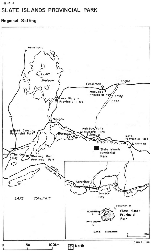
Enlarge Figure 1: Slate Island Provincial Park – Regional setting
3.0 Goal
The goal of Slate Islands Provincial Park is:
To protect significant geological features, plant and animal species and cultural resources of the islands, to provide a variety of outdoor recreation opportunities and to serve as an area for scientific study.
The Park forms part of the Ontario Provincial Parks System as established through the Parks System Planning Program and contributes to the provincial park targets established in the Terrace Bay District Land.
4.0 Objectives
4.1 Protection
To protect the provincially significant elements of the natural and cultural landscape of Ontario represented in Slate Islands Provincial Park.
The Slate Islands have a unique environment that contributes to the achievement of the parks system planning targets outlined in the Terrace Bay District Land Use Guidelines. The protection objective is achieved by including the following features within the Slate Islands Provincial Park:
Earth Science Representation
- an example of tectonic activity in Pre- cambrian bedrock or a central uplift cone of a meteorite impact crater;
- raised beach ridges showing Nipissing and modem beach lines;
- rock platforms, stacks, shorebluffs and other erosional shoreline features of post-glacial times.
Life Science Representation
- a unique faunal assemblage with the absence of predators except the red fox,
- including woodland caribou, beaver and snowshoe hare;
- important native lake trout population;
- unusual arctic disjunct and subalpine plants.
Cultural Representation
- the Northern Hunters and Fishers theme with theme segments representing the peoples of the Iroquoian and Michigan zones;
- early geological exploration and mine development;
- the commercial fishing era;
- early logging history on the north shore of Lake Superior.
Slate Islands Provincial Park will be managed to protect these features.
4.2 Recreation
To provide both developed and unstructured recreation opportunities for activities such as camping, boating, sport fishing, wildlife viewing and back-country hiking.
The management direction will be to support low density use to ensure high quality experiences having minimal impact on the park environment. Although the Terrace Bay District Land Use Guidelines do not assign any targets for recreation, this park will contribute to the District’s day use and backcountry travel opportunities.
4.3 Heritage appreciation
To provide opportunities for exploration and appreciation of the outdoor natural and cultural heritage of Ontario as represented in Slate Islands Provincial Park.
Opportunities will be provided for structured and unstructured heritage appreciation activities through:
- visitor services programming;
- constructing facilities that enhance the users experience such as campsites and trails;
- supporting research complementary to the park.
The Sections under 8.1 Visitor Services list interpretive themes.
4.4 Tourism
To provide Ontario’s residents and out- of-province visitors with opportunities to discover and experience the distinctive geological formations, fauna and flora of the Slate Islands Provincial Park.
Slate Islands Provincial Park protects a particularly rich and diverse natural area. Several features of the Slate Islands are among the most accessible representation of such features in the provincial parks system.
Attainment of the protection, recreation and heritage appreciation objectives for the park will ensure a high quality outdoor environment suitable for low intensity tourism purposes only.
5.0 Park boundary and land tenure
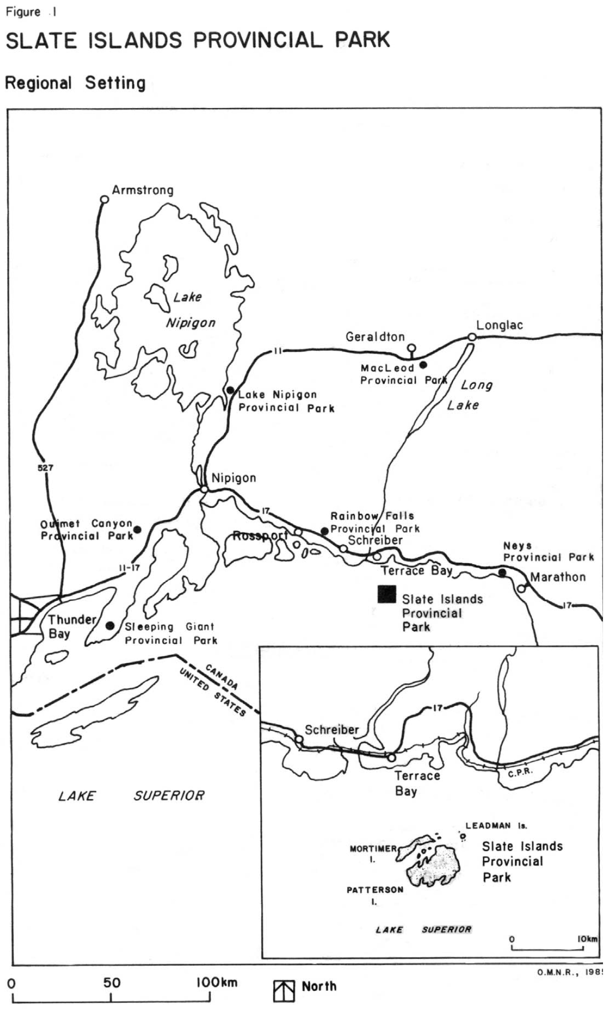
Slate Islands Provincial Park has a total area of 6570 hectares. The waters of Lake Superior account for about 2607 hectares and the islands and inland waters about 3963 hectares. The park boundary is generally located 400 metres in perpendicular distance from the high water mark of the Slate Islands and Leadman Islands, including the water and land under such waters (see Figure 2). The lighthouse complex at Sunday Harbour, comprising some 12 hectares, is owned by the Government of Canada and is not part of the park.
Should the Federal Government decide to dispose of the property, the Ministry of Natural Resources would consider acquisition for park purposes. The property would be incorporated into the park if it were obtained.
At the present time there are five structures located within the park without legal authority. These consist of four cabins and ancillary buildings (i.e. privies and sheds) and one houseboat. This is contrary to the Provincial Parks Regulations, which permit only authorized structures in a Provincial Park. However, the need to provide some sort of public shelters on the islands is recognized. Consequently, the following actions will be undertaken:
- tenure will not be granted to individuals for recreational use of any structures within the park boundaries;
- the Crown will take possession of the existing structures;
- existing structures which are considered safe for park use will be converted to park shelters and will be available to the general public;
- when existing structures within the park become unsafe or are no longer required for park purposes, they will be removed;
- as unsafe structures are removed new public shelters may be provided as funds and priorities permit.
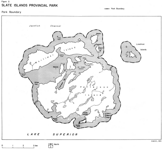
6.0 Park zoning
The zoning for Slate Islands Provincial Park serves to identify and provide recognition to the park features and attributes of provincial significance. The zones delineate areas where management direction will differ in order to effect achievement of the park goal and objectives either by stressing resource protection or accommodating the range of recreational activity permitted in the park.
The park zoning illustrated in Figure 3 generally reflects Optional Plan 2 presented in the Background Information and Optional Plans document released in February 1986. Changes have been made based on public comment and the need to more specifically define and justify the various zones.
Figure 2: Slate Island Provincial Park - park boundary
Enlarge Figure 2: Slate Island Provincial Park - park boundary
Figure 3: Slate Island Provincial Park - park zoning
Enlarge Figure 3: Slate Island Provincial Park - park zoning
There are no historical zones identified for the Slate Islands Provincial Park, although, two significant archaeological features have been identified by the Ministry of Culture and Communication. These sites will be protected from development. Other historical sites have been documented and will also be protected.
The public recreation component typical of most development zones is found dispersed on the mainland through facilities provided at provincial parks, public access points and private campgrounds.
6.1 Nature reserve zones
Nature reserve zones protect significant earth and life science features which require management distinct from that in adjacent zones. The priority for nature reserve zones is protection and research. Protection is ensured through zoning and public education concerning appropriate uses and the enforcement of park regulations. Nature reserve zones provide quality opportunities for low-intensity activities, such as hiking, viewing, photography and nature study.
Development permitted in these zones includes necessary signs, trails, minimal interpretive facilities, and temporary facilities for research and management.
6.1.1 NR1: Mud Lake nature reserve zone (14 ha)
This zone covers the area between Mud Lake and Peninsula Lake. It is about 14.1 hectares in area.
The purpose of this zone is to provide protection for the important caribou crossing area between the two lakes and the research site and salt lick.
No structured recreational activities or development will be permitted to occur in this zone. Approved research activities are permitted. Limits of research will be determined by the park’s Vegetation and Wildlife Management Plans, in compliance with Provincial Parks Wildlife Management policies. Details on research applications are outlined in Section 8.4.
6.1.2 NR2: Leadman Islands nature reserve zone (26 ha)
This zone includes the group of islands situated approximately four kilometres east of Mortimer Island.
The purpose of this zone is to provide protection of the low-lying exposed island landscape, an area of active shorebird nesting, examples of arctic flora species and island flora. The Leadman Islands have areas of cobble and pebble beaches on the west side and large under water rock terraces.
The vegetation association is influenced by the wash zone from Lake Superior and ranges from Arctic, Arctic-Boreal to Cordilleran and Prairie. The islands will remain in their natural state where the forces of nature will operate unimpeded.
6.1.3 NR3: Mortimer Island nature reserve zone; (7 15.5 ha)
This zone includes all the lands and the inland waterbodies of Mortimer Island, except for the Lambton Cove access zone.
The purpose of this zone is to incorporate in the park an area where the forces of nature are allowed to function freely, particularly with respect to the wildlife ecology of the woodland caribou population.
No development is proposed within the nature reserve zone.
Research activity can derive a baseline for measurement of change in other areas of the park and on the mainland. Research activities related to woodland caribou has taken place in this zone prior to the regulation of this provincial park. Future research will be permitted with prior approval from MNR. See Section 8.4 for details.
This zone protects representative landscapes and life science features characteristic of Site district 5, within Site region 3W.
One archaeological site, one historic site and a mining adit are located in this zone. These sites will be protected from incompatible uses.
This zone will provide limited opportunities for unstructured backcountry recreation, such as hiking, wildlife viewing, and scenic viewing. No trail development is proposed and access and travel through the zone will be off-trail.
No permanent or seasonal commercial tourism facilities will be permitted. Tourist operators will be permitted to take or send their clientele into this zone with full appreciation for its purpose and significance, and the lack of facilities and structured recreational activity.
6.2 Natural environment zones
Natural environment zones emphasize resource protection and include aesthetic landscapes in which there is minimum development required to support low- intensity, resource-based recreational activities, such as hiking, viewing, photography and nature study.
Development permitted within these Zones includes trails, necessary signs for route identification, minimal interpretive facilities, and simple facilities to support low-intensity recreational activities.
6.2.1 NE1: Patterson Island natural environment zone (3,192 ha)
This zone includes most of the area of Patterson Island and islands not in the Nature Reserve. The zone consists of about 3,084 hectares of land and 108 hectares of inland waters.
The purpose of this zone is to protect a representative portion of the landscape with a minimum level of development permitted. This is to provide for low to moderate intensity recreational activity.
This zone provides protection of the woodland caribou and beaver populations and wildlife habitat. It will be an area of more intensive wildlife management activity which will comply with the Park’s Wildlife Management Plan.
This zone protects representative landscapes and life science features characteristic of Site district 5, within Site region 3W.
One archaeological site, one historic site and a mining adit are located in this zone. Management direction for this zone will ensure that these sites are protected from incompatible uses, while providing heritage appreciation opportunities. These will include wildlife viewing, geological interpretation and cultural appreciation of pre-historic native habitation, and the mining, logging and commercial fishing history.
This zone will provide opportunities for low to moderate intensity recreational opportunities, including hiking and back- country and shoreline camping. Recreational use is to be encouraged in this zone at a level and in a manner which promotes a high quality experience for all park users, while respecting the need to protect park values.
All recreational and other developments will be carried out in such a manner as to minimize their effect on the natural and cultural resources. Existing trails will be maintained and new trails developed to provide access within the zone. A number of interior campsite locations will be developed to accommodate recreational use.
Research projects which improve the Ministry’s ability to manage the natural resources are encouraged in this zone. See Section 8.4 for details on research activities.
No permanent or seasonal commercial tourism facilities will be permitted. Tourist operators will be encouraged to take or send their clientele into this zone with full appreciation for its purpose and significance. The outfitting and guiding opportunities associated with day-use recreation and overnight camping activity will be encouraged in this zone.
6.2.2 NE2: Lake Superior natural environment zone (2,565 ha)
This zone comprises all of the water, and the lands under the waters of Lake Superior within Slate Islands Provincial Park, except those lands and waters included in the access and development zones.
The purpose of this zone is to provide water-based recreational opportunities such as boating, angling and scuba diving, and to protect and manage the lake trout fishery. This zone also allows for the regulation and control of activities occurring on the water and adjacent to the shorelines, and access to the land base of the park.
Protection of the lake trout spawning beds will be of primary importance in this zone. Projects intended to improve fisheries habitat and/or productivity are permitted. This zone will also provide protection of the shoreline geological and life science features.
This zone protects representative landscapes and life science features characteristic of Site district 5, within Site region 3W.
The zone will provide low-intensity recreational boating and scenic viewing opportunities on Lake Superior.
Generally, no restrictions will be placed on anchoring in this zone and the Ministry will be providing anchorages in certain locations. Should problems of crowding or interference with other uses develop in specific locations, appropriate measures will be implemented to resolve the problem.
Those areas outside of access zones will be treated as harbours of refuge offering shelter to any craft seeking to escape from storms on Lake Superior.
No permanent or seasonal commercial tourism facilities will be permitted. Tourist operators will be permitted to take or send their clientele into this zone with full appreciation for its purpose and significance.
Charter boat activity is to be encouraged in this zone.
6.3 Access zones
Access zones provide access to a number of recreational areas in the Park and serve as staging areas where minimum facilities support use of the less developed natural environment, wilderness and nature reserve zones. Access zones provide relatively intensive recreational activities and their associated facilities and services.
Development permitted within this Zone includes trails, visitor and entry control structures, basic day facilities, and orientation, interpretive, educational, research and management facilities.
6.3.1 A1: Old Barge site access zone (6.5 ha)
This zone includes some of the waters of McGreevy Harbour, Jack’s Island, and a part of Patterson Island. The water area is about 2.7 hectares. Included within the zone are: the remains of the old barge; the cleared site of the old logging camp; and one unauthorized building.
This zone will provide access to the interior trails of Patterson Island. The administrative headquarters, maintenance, research and visitor facilities will be located in this zone.
The old barge will be removed as it is structurally unsafe. The barge and the logging campsite history will be told through a display at the site.
This zone will provide moderately intensive recreation opportunities. Campsites, park shelters, privies, firepits, docks and anchorages will be provided.
A concession agreement for boat and hiking equipment rentals may be permitted in this zone. Tourist operators will be encouraged to take or send their clientele into this zone. Charter boat activity will be encouraged in this zone.
6.3.2 A2: Fisherman’s Harbour access zone (3.8 ha)
This zone is generally defined as the waters of Fisherman’s Harbour and the adjacent land area 50 metres back from the high water mark. The waters of the harbour are about 1.3 hectares. The area has moderately high recreational potential and is considered an important park resource.
This zone will provide access to unstructured recreation and heritage appreciation activities in the natural environment zone on Patterson Island.
This zone provides moderately intense recreation opportunities. Campsites, park shelters, firepits and privies will be provided in this zone.
No permanent or seasonal commercial tourism facilities will be permitted in this zone.
6.3.3 A3: Lambton Cove access zone (7.6 ha)
This zone is located in Lambton Cove on Mortimer Island. This zone generally extends 50 metres back from the high water mark.
The purpose of this zone is to provide a base from which to access the nature reserve zone on Mortimer Island and service a traditional level of use.
Recreational facilities in the form of campsites, park shelters, privies, firepits and docks will be provided.
No permanent or seasonal commercial tourism facilities will be permitted.
6.3.4 A4: Sunday Harbour access zone (38 ha)
The zone is generally defined as the waters of Sunday Harbour and a campsite area at the northeastern end of the harbour, extending 100 metres back from the high water mark.
The purpose of this zone is to provide access to the heritage appreciation opportunities at the southern end of Patterson Island.
Facilities in the form of campsites, park shelters, firepits, privies, docks and anchorages are permitted. Anchorages already established by the light house keeper will be utilized.
No permanent or seasonal commercial tourism facilities will be permitted. Charter boat activity is to be encouraged in this zone.
6.3.5 A5: McColl Island access zone (1.5 ha)
The boundaries of this zone are generally defined as an area on the southwest tip of McColl Island projecting 30 metres into Lake Superior to accommodate docking facilities.
The purpose of this zone is to provide access to McColl Island and camping opportunities.
This zone will provide moderately intensive recreation opportunities. Campsites, park shelter, privies, firepits and docks will be provided.
No permanent or seasonal commercial tourism facilities will be permitted.
7.0 Resource management
Resource management activities undertaken within Slate Islands Provincial Park will conform to the policies for Natural Environment class parks as stated in the Ontario Provincial Parks Planning and Management Policies document. All research activities must comply with Section 8.4 Research.
7.1 Fisheries management
Sport fishing for lake trout constitutes the single greatest recreational use of Slate Islands Provincial Park at the present time. The fishery will continue to be managed in accordance with the policies and regulations prevailing in the area. The management direction stated in this plan is consistent with the direction contained in; the Lake Superior Strategic Fisheries Plan, 1986 - 2000, and the Terrace Bay District Fisheries Management Plan.
There will be emphasis placed on monitoring and managing the lake trout population to maintain and enhance the health of the fishery, and the quality of angling recreation. Approved research applications will be required from Terrace Bay District Office before any research activities are carried out. See Section 8.4.
Section 30, Schedule XV of the Ontario Fishery Regulations state that commercial fishing is not permitted within 1.6 kms. of the Slate Islands.
The Ministry will periodically implement a creel census program to more accurately assess the current level of harvest. The results of this creel census will determine the management strategies that may be required. Should the harvest exceed the total allowable harvest, management options will be reviewed, and the most appropriate technique(s) will be employed to ensure sustained yield.
Spawn collection may be permitted as required to meet a Provincial need for broodstock, with a portion of the hatchery reared fish from Slate Island spawn being released back into park waters, dependent on area productivity and disease implications.
Inland lakes and streams will be evaluated for consideration as to, present stock compositions protecting existing fish species, or sub-species, and the opportunity to enhance a recreational fishery.
7.2 Wildlife management
A wildlife management plan will be prepared:
- to protect and maintain the presence of caribou, beaver and other wildlife species in the park;
- to set direction for research activities; and
- to develop strategies that will emphasize wildlife viewing opportunities.
The objectives of the wildlife management plan will comply with the Provincial Parks Wildlife Management policies. Mortimer Island Nature Reserve will be excluded from any wildlife management activities or prescriptions.
The status of various wildlife species will be determined on a regular basis. Knowledge may be obtained by outside agencies conducting research or by MNR conducted surveys.
The capture and tagging of wildlife for research purposes is permitted. Wildlife species may be transferred for research or restocking purposes. Research, tagging and transferring of wildlife will require necessary permits or approvals from the Terrace Bay District Office. See Section 8.4 for details. Sport hunting and commercial fur trapping will not be permitted. Predator control through the most appropriate means is permitted to protect existing wildlife populations. Domestic pets will be discouraged. Existing Provincial Park Regulations will be strictly enforced. New regulations to prohibit domestic pets from Slate Islands Provincial Park will be sought.
7.3 Vegetation management
The commercial harvesting of timber will not be permitted within the park.
Vegetation management may be carried out to protect or enhance caribou and beaver by creating preferred habitat only on Patterson Island, excluding the nature reserve zone. Techniques used may include non- suppression of wildfires, prescribed burning of standing timber or selective cutting of standing timber. In carrying out vegetation management, unique plant species will be protected. A vegetation management plan will be prepared for zone NE1 Patterson Island. The plan will comply with the intent and objectives of this zone.
All park areas will be managed as an Extensive Fire Management Zone, where all wildfires that threaten life, property or park values will receive a response designed to save life and minimize park and property damage. This response could include fire attack, property protection and/or evacuation. Fire starts will be evaluated and monitored in order to maximize their benefits. Such means of suppression as bulldozing and water bombing with chemicals will not be permitted except in critical situations.
Insect and disease infestations may be controlled where significant park values are threatened, otherwise, they will be allowed to run their natural course. Where control is desirable, biological control will be used wherever feasible, and it will be directed as narrowly as possible to the specific insect or disease, so as to have minimal effects on other components of the park’s environment. No non-native species will be introduced.
Approved research applications will be required from Terrace Bay District Office before any research activities are carried out. See Section 8.4.
7.4 Landform management
Mineral exploration or extraction will not be permitted.
Aggregate extraction will not be permitted. Where aggregate is required for park purposes it will have to be brought in from outside the park.
The mining adits on Patterson Island and Mortimer Island will be fenced to prevent public access. Access for geological research will be permitted provided a research application has been approved. See section 8.4 for details.
7.5 Cultural resources management
The cultural resources which have been identified include:
- two archaeological sites (Mortimer Island and Sunday Harbour);
- the sites of two former logging camps (Logging Camp Lake and Peninsula Lake);
- remains of an old barge and a logging campsite (McGreevy Harbour);
- remnants of coal docks and coal yard from 1930's, (McColl Island);
- two mining adits (Patterson and Mortimer Islands) and
- lighthouse operation at Sunday Harbour (not in park)
Approved research applications will be required from Terrace Bay District Office before any research activities are carried out. See Section 8.4.
7.5.1 Archaeological resources
The archaeological sites are two small campsites representative of the Terminal Woodland cultural period. Both sites are undisturbed. The sites are significant because they indicate the lake-faring skills of the native inhabitants. There is also evidence of foreign influences, i.e. an Iroquoian influence at the Sunday Harbour location and a Michigan influence at the Mortimer Island site.
Archaeologists of the Ministry of Culture and Communications have indicated that more work should be done on the islands and specifically on the identified sites.
The sites will be managed to ensure that they are protected from incompatible uses. The following strategies will be taken to protect the identified sites:
- no recreational developments will be built within 100 metres;
- the locations will not be specifically pinpointed for the public.
Further surveys of the islands by the Ministry of Culture and Communications will be encouraged, to identify any additional sites. Excavation and disturbance of the sites will only be permitted by representatives of, or persons authorized by, the Ministry of Culture and Communications.
7.5.2 Historical logging resources
Logging activities occurred on the Slate Islands in the 1930's. Prior to 1935, timber harvesting was carried out, and camps were established on the islands. After 1935, the islands were used as booming grounds for the trans-shipment of timber to the United States. The campsites, remains of an old barge, coal docks, and old roads, are evidence of this era. These features represent an important part of the history of the park.
The following management strategies will be implemented:
- the locations will be protected from incompatible uses which could alter or destroy the site; and,
- excavation of the sites should be carried out by the Ministry of Culture and Communications in order to rescue and preserve artifacts.
7.5.3 Lighthouse complex
A lighthouse was first established on the Slate Islands in 1902. The present location is not part of the park, however it is of interest to park users. The lighthouse is owned and operated by the Federal Government.
7.5.4 Historical mining resources
Two sites that represent the mining history of the Slate Islands are mining adits from the early twentieth century. The adits are hazardous areas which could result in injury to unsuspecting park users. Consequently, steps such as fencing and/or signage will be taken to warn people of the potential hazards. If the sites become part of the interpretive program, more elaborate safety precautions may have to be taken.
8.0 Operations policies
A Park Operations Strategy will be prepared to provide park staff with the necessary information required to operate the park on a day-to day basis. In addition to addressing the operations policies which follow, the strategy will include such topics as budget, staffing, maintenance schedules, enforcement and emergency services. The provisions of the strategy will be consistent with the approved Ontario Provincial Parks Operating Standards, and will be reviewed annually and updated as required.
8.1 Visitor services
The primary objective of the visitor services program will be to orient park visitors to the natural, educational and recreational attributes of Slate Islands Provincial Park. The level of visitor services will be at self- use including publications and display panels to deliver park information, resource interpretation, recreational skills and park management messages.
8.1.1 Park information
A public information program for park visitors will be established. A park map will be produced to enable users to safely explore and use the islands. Visitors will be advised to exercise caution regarding safety hazards. Information will be presented cautioning visitors regarding travel on Lake Superior, particularly as it pertains to severe weather conditions.
A "leave no trace" attitude will be promoted in order to minimize human impact on the park environment. Information may also be given concerning appropriate human interaction with wildlife.
Park literature will inform visitors about the commercial services and attractions that are available in the area to enhance their stay, and to generate local tourism benefits.
8.1.2 Interpretation
The major interpretive themes for the park are outlined below. All themes incorporate and reflect the island character of the park and the influences and effects of Lake Superior.
Island geology, geological formations and geomorphology:
The Slate Islands contain excellent examples of rocks formed in a broad range of volcanic and intrusive environments. In addition, there is abundant evidence of a complex metamorphic and structural history.
Within a regional and provincial context, the geology of the Islands is significant. Local generation of earth systems or mechanisms have resulted in an interesting and intriguing stratigraphic succession of volcanic rocks and associated breccias. The occurrence of shatter cone features in island rocks is significant as they may support the controversial theory that the Slate Island structure is the result of a hypervelocity (meteorite) impact.
Differential erosion since glacial time has resulted in a very unique coastal shoreline marked by precipitous walls, rock jutting points, pebble and cobble beaches.
Island flora:
Island vegetation reflects the characteristics of the Lake Superior section of the Boreal (northern) forest. In addition to species characteristic of the northern forest, the island’s exposed rocky promontories provoked habitat for a wide variety of lichens and a number of arctic-alpine species. A small colony of Devil’s club (Oplopanax horridus.), a plant that is considered rare in Ontario, is located on one of the islands.
Island fauna (woodland caribou/beaver):
The island habitat presents a predator free environment for a number of prey species, specifically woodland caribou and beaver.
Caribou may at times exist at a density of 7 to 11 per square kilometre, the highest densities in North America. In the absence of predators, the caribou populations have experienced a series of boom-bust cycles, the most recent bust having occurred during the winter of 1989-90, when caribou numbers fell from a high of 600 in the fall of 1989 to approximately 100 in the spring of 1990.
Both the caribou and beaver have been influenced by and profoundly influenced the vegetative mosaic of the islands. The interplay between the animals and their environment as well as the dynamics of the caribou and beaver populations will be major themes in the park’s visitor services program.
Island fisheries:
The shelter afforded by the Slate Islands offer spawning beds for Lake Superior populations of Lake Trout.
Island history:
The theme of human habitation on the Slates will be explored through the off-site interpretation of the archaeological features, as well as the many remnants of past logging, mining and fishing operations.
Information will be presented in such a way as to intensify the feeling of isolation and the grandeur which is so readily perceived in the island landscape. Interpretation will be primarily self-directed through the use of published material and static displays where appropriate.
8.1.3 Recreation
Recreation information will acquaint park visitors with the recreational attributes of the park and the skills required for minimum impact use of the park. The park map will serve, as the basic information for this purpose. With improved skills, visitors will make better use and enjoyment of the park while minimizing their impact on the environment.
8.2 Recreation management
Presently, it is not economically feasible to collect park fees through personal service fee collection. Self-serve collection boxes may be placed at park access points or park facility locations.
Campfires will only be permitted in established fireplaces. No standing trees, alive or dead, may be cut for firewood, and firewood cutting will be limited to dead, fallen-down trees, or utilization of washed- up timber along the shoreline.
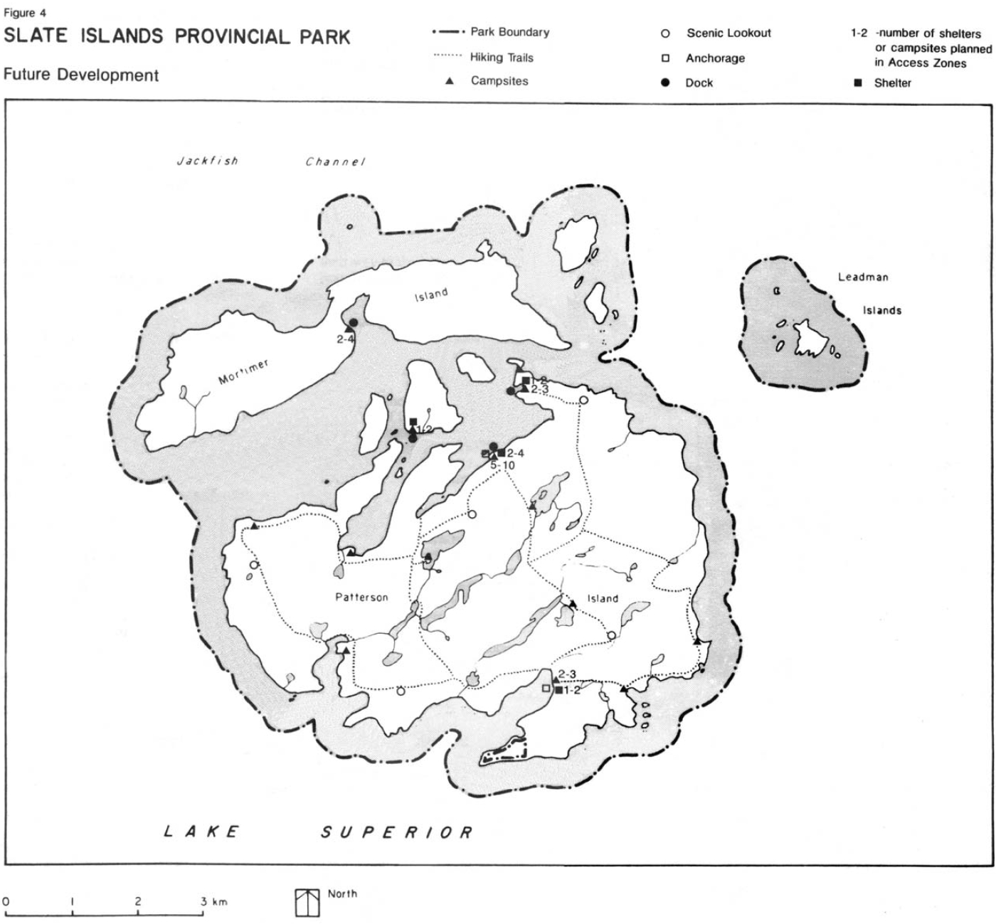
While continuing to provide opportunities for unstructured recreation, the Slate Islands will provide structured opportunities through the minimal development of trails, campsites, docks, shelters and anchorages. A Recreation Management Plan will be prepared to determine the phasing of campsite development, the configuration and route of trails, to accommodate extended (overnight) and day hikes. Trail routes will avoid sensitive or critical cultural or natural areas (habitats); provide opportunities to see wildlife, explore geological and geomorphological features and access natural vistas. Blinds or wildlife observation areas will be incorporated into the trail plans to enhance visitor opportunities to observe caribou and beaver. Trail construction standards will be designed to meet the needs of the intended user group. Trail locations (Figure 4) are approximate.
Camping areas will be designated to minimize vista impact and located to achieve a desirable distribution of interior and shoreline use and to provide a variety of camping alternatives.
The docks and anchorages will enhance the boating opportunities through structured facilities. The public may anchor anywhere along the shoreline.
The shelters located at various campsites are intended for use as emergency refuge on a temporary basis. Extended use is to be discouraged.
Motor powered watercraft and aircraft will represent the only forms of mechanical transportation permitted. Permits are required to authorize aircraft landings within the park. As fee collection is initiated boats will require a camping or daily vehicle permit.
Other controls may be required to protect the park environment from inappropriate uses and overuse, to ensure that visitors enjoy high quality experiences. Such controls will be gradually phased in, and directed at resolving specific concerns.
The preparation of a Recreation Management Plan for Patterson Island will determine the recreational and interpretive opportunities for users of power and sail craft as well as for canoeists and sea kayakers.
8.3 Commercial tourism services
Disposition of land within the park for commercial tourism purposes will not be permitted. Major commercial facilities to service the park will be encouraged on the mainland.
Minimal commercial docking facilities and boat and hiking equipment rental services may be permitted at the Old Barge Site (Zone A1) through a concession agreement.
8.4 Research
Research that will contribute to the knowledge of natural and cultural history and to park management will be encouraged. As well the park’s earth and life science attributes make it well-suited as an area for group field study and outdoor education.
Small groups with a particular interest in the resources of the Slate Islands will be encouraged to visit the park. Collections and/or sampling may be approved under certain circumstances. Group use will be monitored, and if adverse environmental or visitor impacts are detected, stricter controls may be put in place and measures may be developed to improve facilities for group use or mitigate the impacts. The curricula and teaching will be the responsibility of the teacher or group leader; however, resource information will be available from Ministry staff.
All research including MNR programs and other government agencies and ministries must be approved and conducted in accordance with the Parks and Recreational Areas Branch policy concerning research in provincial parks. All research must conform to the objectives of the Park Management Plan and the prescriptions of the companion Park Wildlife and Vegetation Management Plans. As directed by policy for Research Activities in Provincial Parks and Park Reserves, all research proposals must be directed to the District Manager in Terrace Bay.
A research area of interest will continue to be the study of caribou and beaver populations and the interaction of herbivore and plant species. High numbers of caribou and beaver allows for increased observation opportunities that permits behavioral study that would be difficult to get in most boreal forest locations.
Research to improve the understanding of the geological formations found on the Slate Islands, particularly with respect to the origin of the Island complex, i.e. volcanic or meteorite impact., is to be encouraged.
There are also opportunities to continue research on the existing flora, including the arctic disjunct plant species and the species associated with habitat and food sources for wildlife.
Two Indian campsites have been examined from the Terminal Woodland cultural period and there is interest in more archaeological study of the islands by the Ministry of Culture and Communications.
Fisheries research, both of the lake trout, and of the fish species that may be present in inland waters would also be supported.
8.5 Marketing
A marketing plan will be prepared for the park in accordance with established Ministry policy and procedures, and consistent with the North Central Region Marketing Strategy. The park marketing plan will:
- Identify recreational and heritage appreciation opportunities and activities that are most appropriate to the unique character and sensitive nature of the islands
- Identify the level(s) and location(s) of visitor facilities, services and information/interpretation programs that will: effectively protect the heritage resources and secluded character of the islands; support and encourage appropriate recreational and heritage appreciation activities; and inform park visitors, prior to and during their visit of the inherent dangers of travel on Lake Superior and the self-sufficiency requirements of island visits.
- Identify opportunities for local tourism operators to provide basic services (supplies, transportation, equipment, accommodation) and information to park visitors or perspective park visitors.
- Recommend promotional initiatives targeted to specific local, provincial, national or international user or activity groups.
9.0 Development
Development will be implemented through work program planning based on priority and subject to the availability of funds. All development will be carried out in accordance with approved Site and Development Plans which detail the location, type and extent of development permitted.
The development of facilities will only occur in the access, and natural environment zones as follows:
Access Zone A-1: Old Barge Site
- 5-10 campsites
- 2-4 shelters
- privies
- picnic tables and fireplaces
- park storage and office facilities
- research facilities
- minimal commercial docking facilities and boat rental services may be considered
- dock and anchorages
Access Zone A-2: Fisherman’s Harbour
- 2-3 campsites
- 1-2 shelters
- privies
- picnic tables and fireplaces
- dock
Access Zone A-3: Lambton Cove
- 2-4 campsites
- privies
- picnic tables and fireplaces
- dock
Access Zone A-4: Sunday Harbour
- 2-3 campsites
- 1-2 shelters
- privies
- picnic tables and fireplace
- anchorages
Access Zone A-5: McColl Island
- 1-2 campsites
- 1 shelter
- privies
- picnic tables and fireplace
- dock
Natural Environment Zone NE- 1: Patterson Island
- 6-12 campsites
- privies
- picnic tables and fireplaces
- approximately 40 kilometres of hiking trails
- Natural Environment Zone NE-2: Lake
- Superior
- anchorages
The locations of the proposed developments are shown in Figure 4. Development will be phased in as outlined in Appendix A.
10.0 Implementation
Implementation of the management plan will involve resource protection, client services, and the development of approved facilities. It will be based on work program planning and funding. The intent of the strategy is to provide a logical, ordered approach to guide the implementation of the park management plan over the 20 year planning period.
To be effective and efficient there needs to be communication and cooperation with other public agencies and private groups and individuals to satisfy the intents stated in the plan.
10.1 Implementation phases
Figure 4: Slate Islands Provincial Park - future development

Enlarge Figure 4: Slate IslandsProvincial Park - future development
10.1.1 Phase 1
Completion of this phase will remove safety hazards, initiate resource planning and provide basic facilities:
- remove old barge
- remove old houseboat
- prepare a Patterson Island Recreation Management Plan and begin construction of first phase campsite, shelters, docks and privies in access zones and hiking trails
- protect significant park features
- replace research and park management facilities
- remove or replace existing structures with park shelters
- prepare an information program for park visitors including displays and maps
10.1.2 Phase 2
Completion of phase 2 will continue to provide park facilities and encompass park resource plans
- encourage appropriate research activities
- install park signs for information
- prepare resource plans i.e. wildlife, vegetation, marketing
- construct second phase campsites, shelters, docks and privies in access zones
- construct anchorages
- construct second phase hiking trails and interior campsites
- prepare park operating strategy
- construct park office and storage facilities
- prepare an information program for park visitors including displays and maps
10.1.3 Phase 3
Completion of this phase will finalize development of park facilities and provide a visitor services program
- prepare an information program for park visitors including displays and maps
- complete campsites, shelters, docks and privies in access zones
- complete trails and interior campsites
- complete anchorages
11.0 Summary of public consultation
The management planning process has provided Ministry staff, concerned organizations and the general public with the opportunity to identify significant issues and discuss possible solutions.
11.1 Background information & optional plans
In January and February of 1986, the public was invited to review and comment on the Background Information and Optional Plans document for the Slate Islands Provincial Park. Informal talks were held at Marathon and Red Rock with the local fish and game clubs. Public meetings were held at Terrace Bay.
11.2 Preliminary management plan
Notices were placed in local newspapers in Terrace Bay/Schreiber, Marathon, Nipigon, and Thunder Bay to offer a review and solicit comments on the preliminary management plan. A public information centre was held in the Terrace Bay District Office on November 13, 1986. Copies of the preliminary management plan were also mailed out to 132 groups and individuals who indicated interest and/or had responded earlier in the planning exercise.
The following is a summary of the main points of concern raised during the public review of the Preliminary Management Plan for the Slate Islands Provincial Park.
Mineral exploration and development
The majority of the people who commented in this regard, were opposed to any form of mineral exploration or extraction taking place. The strongest comments for this development were received from the mining fraternity. The decision of Cabinet in 1988 not to allow any mineral exploration or extraction in provincial parks has been reflected in this document.
Wildlife management
A controlled harvest of caribou was suggested as an acceptable form of population management. However, other responses were opposed to this activity taking place. One response suggested predators not immediately be controlled if they should make their way to the islands. Instead, the caribou population should be monitored.
Fisheries management
Public comments urged increased protection for the lake trout population around the Slate Islands either by stronger regulations under the Game and Fish Act or by enlarging the boundary of the park to 1600 metres from the islands to match the non-commercial fishing zone.
Park facility development
Most responses favoured minimal development for the Slate Islands. Specific suggestions were made for the careful planning of trails and campsites to have regard for use made by hikers and boaters. Mention was also made about the need for a better launching site on the mainland to access the Slate Islands Provincial Park.
Commercial tourism development
One response suggested the underutilization of the resource would occur if a lodge facility were not developed in the park.
Vegetation management
A suggestion was made to control vegetation by the use of fire.
References
- Bergerud, A.T., Butler, H.E., The Unusual Story of the Slate Islands Caribou; Nature Canada, vol. 7 number 1, Jan./Mar. 1978.
- Billings, M.D., Slate Islands Environmental Planning Series Earth Science Report, 1974; OMNR Division of Parks, North Central Region, 1974.
- Dalton, W.J. Background Report for the Slate Island Provincial Park Management Plan (unpubl.); prepared for the Ontario Ministry of Natural Resources, Aug., 1985.
- Englebert, P., Newton, B., Arthurs, D. North Central Archaeological Survey, 1974; prepared for MNR, Division of Parks, Historical Sites Branch, 1974.
- Euler, D., Timmerman, H.R., Snider, J.B. The Slate Islands, Ontario Ministry of Natural Resources, (unpubl.), 1975.
- Goodier, J.L. Native Lake Trout (Salvelinus Namaycush) Stocks in Canadian Waters of Lake Superior Prior to 1955; Prepared for OMNR, 1981.
- Goodier, J.L. The Fish and Fisheries of Canadian Lake Superior; Institute for Environmental Studies, University of Toronto, 1982.
- McGregor, C.A. The Slate Islands - Environmental Planning Series Life Science Report, 1974; OMNR Division of Parks, North Central Region, 1974.
- McKay, G.A., Crowe, R.B., Baker, W.M. The Tourist and Outdoor Recreation Climate of Ontario; Environment Canada, vol. 1, Objectives and Definition of Seasons, Publications in Applied Meteorology REC-1-73; prepared for Ministry of Industry and Tourism, Prov. Of Ontario, by Atmospheric Environment Service, Dept. of Env. Canada, Toronto, 1973.
- Noble, Terry. Ontario Nature Reserves Program - Life Science Inventory Check Sheet. Slate Islands. OMNR, North Central Region, January 23, 1978.
- Ontario Provincial Parks Planning and Management Policies: Ministry of Natural Resources, 1978.
- Provincial Parks Act, Revised Statutes of Ontario, 1980.
- Sage, R.P. Mineral Potential of the Slate Islands and Lake Superior Land Use Plan, Ontario Division of Mines, Ministry of Natural Resources, Jan 1975.
- Sage, R.P., Ontario Geological Survey Open File Report 5435 Geology of the Slate Islands, Ministry of Natural Resources, 1983.
- Slate Islands Provincial Park, Background Information and Optional Plans, Ontario Ministry of Natural Resources, 1986.
- Terrace Bay District Land Use Guidelines, Ontario Ministry of Natural Resources, 1983.