Snake River Marsh Conservation Reserve Management Statement
This document provides policy direction for the protection, development and management of the Snake River Marsh Conservation Reserve and its resources.
Statement of Conservation Interest (C44)
Approval statement
We are pleased to approve this Statement of Conservation Interest (SCI) for the proposed Snake River Marsh Conservation Reserve. It is one of 378 new protected areas approved through Ontario’s Living Legacy, a land use strategy aimed, in part, at completing Ontario’s system of parks and protected areas.
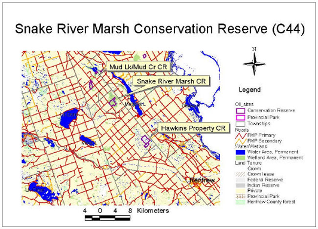
The proposed Snake River Marsh Conservation Reserve located in ecological Site District 6E-16, is a 213-hectare deciduous swamp and marsh complex, situated approximately 20 kilometers southeast of Pembroke, directly east of Muskrat Lake. The property was acquired by the province in 1975 and comprises the Crown land portion of a much larger (880 ha) Provincially Significant Wetland (PSW). The serpentine Snake River meanders slowly through the eastern and northern portions of the site, enroute to Muskrat Lake. Almost completely surrounded by rich agricultural lands, the site is part of a natural-areas travel corridor, extending from the Lake Dore Hills to Muskrat Lake.
This proposed conservation reserve is situated within an area of eastern Ontario encompassed by the Algonquin Nation land claim. The Ministry of Natural Resources and the Algonquin Nation are developing a protocol to guide discussions on a number of land use matters, including implementation of Ontario’s Living Legacy Land Use Strategy.
The proposed Snake River Marsh site has unique values that would benefit from protection at this time. The values at this site may be expanded in the future with the identification of other unique values through the protocol consultation process with the Algonquins. This SCI will protect the values of this site during the consultation process.
This Statement of Conservation Interest provides guidance for the management of the proposed Snake River Marsh Conservation Reserve and provides the basis for the ongoing monitoring of activities. More detailed direction is not anticipated at this time.
The proposed Snake River Marsh Conservation Reserve is managed under the jurisdiction of the Madawaska River Area Supervisor, Pembroke District, Ontario Ministry of Natural Resources.
Approved by:
Ray Bonenberg
District Manager
Pembroke District
Approved by:
Ron Running
Regional Director
Southcentral Region
1.0 Introduction
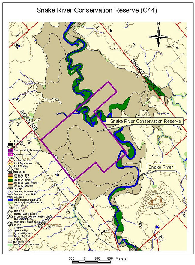
The proposed Snake River Marsh Conservation Reserve, located in part Lots 25-27, Concessions 1 & 2, Bromley Township consists of deciduous swamps of silver and red maple, black ash and elm and a marshy, riverine system.
Originally purchased by the province in 1975, the proposed reserve was acquired through funding provided by the Agriculture Rehabilitation Development Act (ARDA) with the intent of managing the site for forestry purposes. A small area within the site had been rented for hay production, but the land use permit was cancelled. Approximately 12 ha of larch were planted on the west portion of the site and in 1984 approximately 4 ha was harvested for fuelwood. Generally speaking however, the proposed reserve is largely intact in terms of forest cover (Yaraskavitch 1998).
The Snake River drains the clay plain between Osceola and Muskrat Lake (Chapman and Putnam, 1984). The slow moving river is approximately 15-20 metres wide with deep muck and detritus substrate (MM Dillon, 1993). Overall, the Snake River wetland likely provides a filtering function for the watershed, catching and holding onto silt, nutrients and chemicals in the runoff from surrounding agricultural lands (OMNR, 2000).
In a larger context, the proposed reserve falls within the Great Lakes-St. Lawrence Forest Region (Chambers et al. 1996). The relatively low elevation of the Ottawa Valley moderates the climate of the area, allowing for the occurrence of plants, which typically grow in more southerly locations (Chambers et al., 1996). Additionally, the area is influenced by a rain shadow effect owing to its position on the lee side of the Algonquin Highlands, and as a result, the Renfrew County area of the Ottawa Valley has the driest climate of the region (Chambers et al. 1996).
The proposed reserve also lies within the Ottawa Valley Clay Plains, which extends between Pembroke and Hawkesbury. In the upper section above Ottawa, swamps are scarce and the surface of the clay beds is level in all but a few areas. The deep silty-clay sediments are likely derived from Precambrian parent material (Chapman and Putnam, 1984).
The Snake River Marsh was identified by the Great Lakes - St. Lawrence Round Table as a candidate conservation reserve during the Lands for Life planning process (February 1997 to May 1999). This conservation reserve was one of 378 new provincial parks and conservation reserves which the government of Ontario announced its intention to regulate with the July, 1999 release of Ontario’s Living Legacy Land Use Strategy (LUS). The LUS, in addition to recognizing the proposed new parks and conservation reserves, identifies permitted uses and sets out land use intent for the sites.
Prior to the finalization of the boundaries of the proposed Snake River Marsh Conservation Reserve, Pembroke District OMNR staff sent out boundary consultation packages to potentially affected stakeholders (such as adjacent landowners, resource users, municipalities and interest groups and organizations), inviting comment on the proposed boundaries. Provincial interest groups and organizations were sent boundary consultation packages as well. Public notices were also placed in local newspapers during this period.
There were no significant issues raised during public consultation - only four responses were received. One resident commented that he knows of landowners who may be willing to sell/donate portions of their land that are part of the Snake River Marsh in order to expand the proposed conservation reserve; two inquired about what the designation meant and what effect the reserve would have on private land; and one was concerned whether hunting would be allowed to continue.
Figure 1: Location Map
 etc.">
Figure 2: Site Map
The purpose of this Statement of Conservation Interest (SCI) is to identify and describe the values of the proposed Snake River Marsh Conservation Reserve. The SCI also outlines the activities that occur within the proposed reserve and provides guidelines for the management of current and future activities in the context of protecting the natural and cultural values.
Conservation reserves are established by Regulation under the Public Lands Act. Statements of Conservation Interest are prepared under the authority of Procedural Guideline A – Resource Management Planning (PL-Procedure 3.03.05).
1.1 Background information
| Name | Snake River Marsh (Proposed) Conservation Reserve |
|---|---|
| Ecological Site Region / Site District | 6E-16 (formerly 5E-12) |
| OMNR Administrative Region/District/Area | Southcentral Region / Pembroke District / Madawaska River Area |
| Total Area (hectares) | 213 ha |
| Regulation Date | Pending |
| First Nations Interests | Algonquins |
| OBM map sheets | 10 18 3450 50550 |
| UTM Coordinates | 10 18 346500 E / 5057500 N / (NAD 83) |
1.2 Representation/targets
Earth science representation:
According to the Earth Science report by Duba & Frey (2001), the bedrock geological features of the Snake River Marsh provide insignificant representation of underlaying Paleozoic or Mesozoic geological history. Surficial geology however, is locally significant in its representation of the Wisconsinan glaciomarine deposits of the Quaternary Era.
Life science representation:
While the site contributes to the life science representation values of ecological Site District 6E-16 (formally known as 5E-12), it primarily s erves to protect the Crown land portion of a Provincially Significant Wetland (PSW) – the Snake River Marsh.
Cultural resources representation:
Cultural resources inventories have not been completed for this proposed conservation reserve. The Algonquins have identified value areas in the vicinity of Snake River Marsh although none of these sites is located within the proposed conservation reserve.
As mentioned previously, the Snake River Marsh site was purchased by the province in 1975 through ARDA funding with the intent of managing the site for forestry purposes. A small area within the site was rented for hay production and approximately 12 ha of larch were planted. As well, approximately 4 ha of fuelwood were harvested in 1984. Presently, a grassy strip of land along the southwest boundary of the site contains the ruins of a small outbuilding as well as plant species typical of pastureland (Yaraskavitch 1998).
1.3 Survey information
This section provides an overview of the inventories completed their level of detail and any further inventory work required.
| Survey level | Earth sciences | Life sciences | Cultural | Recreational | Other |
|---|---|---|---|---|---|
| Reconnaissance | Frey and Duba, (2001). | Davis, Moore & Hiscock (2001); Merchant, Moore & Hiscock (2001); Hiscock & Hiscoc k (2002); Coulson, 2002. Life Science Check-sheet (Merchant 2002); |
None known | Davis, Moore & Hiscock (2001); Merchant, Moore & Hiscock (2001); Hiscock & Hiscock (2002); Coulson, 2002. Recreation Inventory Report (Hiscock, 2002) | Buckland, L. and Beaudette S. Snake River Marsh Wetland Evaluation, (1985); Initial Technical Reports: Highway 17 Environ-mental Assessment- Haley Station to Meath Hill – Fisheries. Draft, (Dillon Consult. Ltd., 1993); Final Technical Reports: Highway 17 - Haley Station to Meath Hill Environmental Assessment and Route Planning Study, (M.M Dillon Ltd.,1995) |
| Detailed | no | no | no | no | no |
| Requirement | no | yes | yes | no | no |
2.0 Values to be protected
This section provides a description of the key natural heritage values of the site and their condition relative to past and present resource use and management activities. It also addresses the sensitivity of these values to future land use and management activities.
This proposed conservation reserve is located within Hills (1959) ecological Site District 6E-16 (formerly 5E-12). Values include earth science, life science and recreational features.
2.1 Earth science
Earth science values are focused on features (bedrock and surficial) that represent the chronology of earth history in the province (Davidson 1981).
According to the Earth Science report by Duba & Frey (2001), bedrock exposure is rare to absent in the proposed reserve and none was identified from the helicopter overview. Previous mapping by Russell and Williams (1985) established that the Snake River Marsh is underlain by lower Paleozoic calcareous sedimentary rocks, preserved in a downfaulted outlier of the Ottawa-Bonnechere Graben within the northern part of the Bancroft Terrane (Central Metasedimentary Belt), Proterozoic Grenville Province.
Within Ontario’s protected areas system, the bedrock geological features of the Snake River Marsh provide insignificant representation of underlaying Paleozoic or Mesozoic geological history. Surficial geology is locally significant in its representation of the Wisconsinan glaciomarine deposits of the Quaternary Era.
2.2 Life science
Representation:
The proposed Snake River Marsh Conservation Reserve was acquired by the province in 1975, and is the Crown-owned portion of a much larger (880 ha) marsh situated in the middle of the rich agricultural land of the Ottawa Valley Clay Plain (Chapman and Putnam). The soils are shallow to deep organic deposits, overlying mildly calcareous, granitic, fine-textured material. The Snake River is a meandering stream draining the surrounding farmlands, and winds in and out of the reserve on its eastern side.
An evaluation of the Forest Resource Inventory (FRI) mapping provides information on the forest resources found on the site. Sixty-three percent of the proposed reserve is considered productive forest while 34% is classified as brush/alder, with the remaining 3% as water (OMNR, 2001c). Along the river are marshy areas, a mosaic of many species of grasses, sedges, cattails, etc, changing width and composition with the direction of the river, and grading into the thicket swamps and treed swamps behind. Marsh ecosites such as Cattail, MAS3-1 are present. Farther back from the river, the dominant ecosite is Organic Thicket Swamp, as classified by the Ecological Land Classification for Southern Ontario (Lee et al, 1998). Alder and willow swamps are the main vegetation types. Scattered silver maple and black ash are present in some areas, giving a canopy closure of about 10%. Thicket swamp also occupies a large, circular depression in the middle of the reserve. Farthest from the river, black ash and silver maple are more abundant, and form Organic Deciduous Swamp ecosites (SDW5 and SDW6 (Lee et al, 1998)). White elm, red maple, white cedar and tamarack occur as small and localized components of the stands.
The vegetation communities of the larger marsh area seem to be well represented within the reserve boundaries.
A strip of land along the western boundary of the proposed reserve (Stafford 3rd line) is a grassy area with scattered immature tamarack and with species typical of pastureland (CUM1, Mineral Cultural Meadow Ecosite). A small area (<0.25 ha) of bedrock exposure/shallow soil is also present (CUM2, Bedrock Cultural Meadow Ecosite).
While the Snake River Marsh provides good representation of the above-described communities, the parcel was originally identified for protected area regulation due to its significant wetland values, not on the basis of life science representation.
Condition:
The marshes and swamps are largely inaccessible, and are undisturbed. The river itself, however, is degraded, extremely so above the marsh. The water quality changes from one end of the reserve to the other, with turbidity decreasing and plant diversity increasing downstream. As a result, surrounding land use is affecting the nutrient status of these wetland ecosites, and the plant abundance and composition.
Many introduced species, typical of pasture, can be found in the strip of cleared land on the west side of the proposed reserve.
Diversity:
The low relief and subsequent meandering nature of the river leads to a highly diverse riverside. The numerous marsh ecosites are varied in size and composition. The remaining parts of the proposed reserve support only a few ecosites, but these are diverse within themselves. The alder-willow thicket swamps are extremely productive and diverse, with tall shrubs, sedges, and scattered trees, and tangled ground vegetation and hummocks. Vertical diversity is high. Although there is little variation in the overall character of the silver maple-black ash areas, there are patches of wetter and drier areas, creating many microsites. Species noted include jewelweed, swamp milkweed, water arum, nightshade, Virginia creeper, currants, meadow rue, water plantain, water hemlock, duckweed, stinging nettle and cattails.
The strip of grassy land along the western boundary of the proposed reserve adds to the wildlife habitat and food supply, and overall diversity. The many species found in this area include pink clover, vetch, thistles, strawberry, red-osier dogwood, milkweed, timothy, goldenrod and chokecherry.
There is a high level of wildlife diversity in the area. Almost completely surrounded by agricultural lands, the site is part of a natural-areas travel corridor, which extends from the Lake Dore Hills and Upper Osceola Marsh through to Muskrat Lake. Many species of dragonflies and butterflies were observed during field visits as well as various song and migratory birds and several species of raptors. One completed stick nest and three satellite nests are located within 150 metres of Egan Road, along the southwest boundary of the proposed reserve. The nests require identification and it is unknown whether the main nest is active. The proposed reserve provides ideal habitat and vegetation for breeding and nesting purposes (shallow marsh, open water, and tall grasses and rushes) and the birds in turn utilize the surrounding agricultural fields for feeding. Marsh wrens and black-billed cuckoos also frequent the site. Presently, it is the only known location for nesting sand hill cranes in Renfrew County.
The Snake River itself, slow moving and marshy, provides ideal habitat for muskrat and beaver, snapping and painted turtles, and a substantial population of bullfrogs. It also supports warm - water fish communities of northern pike, largemouth bass, brown bullheads, yellow perch, pumpkinseed, rock bass as well as many species of forage fish (shiners, dace, sticklebacks , darters, mud minnows) (Dillon, 1993). The area of the river from Muskrat Lake to the end of Snake River Wetland (Osceola) is identified as critical habitat for northern pike (Dillon, 1993).
Lying within 3.5 km of the eastern edge of the Germanicus deer wintering area, the proposed Snake River Marsh Conservation Reserve provides some habitat for deer. However, the flooded swamp and marsh areas are more suitable for small mammal species such as snowshoe hare, mink, fisher, fox and raccoon as well as bird species such as ruffed grouse, woodcock, snipe and wild turkeys which have been recently introduced into the area.
The proposed Snake River Marsh Conservation Reserve comprises approximately 22% of the larger Snake River Marsh Provincially Significant Wetland (PSW). According to the wetland evaluation report of 1985 (Buckland & Beaudette) the Snake River wetland as a whole provides breeding or feeding habitat for marsh wren, river otter, northern harrier, black tern and redhead duck. According to the Natural Heritage Information Centre (2002) the black tern is considered to have sensitive status in Ontario and has a provincial rank of S3B (rare to uncommon in Ontario), SZN (non-breeding migrants). The redhead duck may be at risk in Ontario and has a provincial rank of S2B (very rare in Ontario), SZN (non-breeding migrants). Both species are globally common. The wetland evaluation also notes that the PSW is considered locally significant for waterfowl breeding, staging and migration. Within the site, wood ducks, black ducks, common mergansers, killdeer and kingfishers were observed during a field visit to the river and nesting boxes were observed along the river’s edge. Wood ducks can also be found in the flooded swamps along Egan Road.
Ecological considerations:
The surrounding agricultural land use is of concern to the integrity of the marsh. The river directly upstream from the reserve is clogged with weeds and exhibits other signs of nutrient loading. Farther upstream it is brown, turbid, and almost devoid of vegetation. The marsh is acting as a sink for the nutrients in the river. However, the ability of this wetland to continue to filter effectively in the long term is a consideration for management planning. Because most of the surrounding land is privately owned agricultural land, improved education in riparian stewardship could improve the condition of this proposed reserve.
Special features:
This proposed conservation reserve is part of a much larger (880 ha) provincially significant wetland system. It is also one of the few pieces of Crown-owned, natural, undisturbed landscapes in ecodistrict 6E-16.
Good waterfowl habitat exists within the proposed reserve as well as on surrounding agricultural lands.
Significance:
The proposed conservation reserve is part of a provincially significant wetland, and is considered a locally significant wildlife area.
2.3 Recreational values
On a local scale, the Snake River Marsh PSW is a popular waterfowl hunting area. The proposed reserve also plays a minor role in providing local opportunities for hunting large and small game species.
The extent of winter activities such as cross-country skiing and snowshoeing are assumed to be low or infrequent, however one of the "TOP" (Trans-Ontario Provincial) trunk snowmobile trails passes through Osceola and continues within 1.5 km of the west side of the proposed reserve (Eastern Ontario Snowmobiling Touring Region 2002 Trail Map). Local snowmobilers utilize the Snake River corridor to access Muskrat Lake from Osceola. There are no known developed or maintained trails within the wooded area of the proposed reserve.
The Snake River between Osceola and Muskrat Lake is similarly used in the summer by local boaters and canoeists. Local field naturalists canoe the river for the purpose of birding expeditions.
Although at present the proposed Snake River Marsh Conservation Reserve is primarily used for hunting, its easy access also provides for many additional eco-tourism/viewing opportunities (Yaraskavitch, 1998). These opportunities are assumed to be underutilized and could easily provide a future draw to the site.
3.0 Management guidelines
3.1 Land tenure
Background:
The proposed Snake River Marsh Conservation Reserve located in part Lots 25-27, Concessions 1 & 2, Bromley Township was originally purchased by the province in 1975. The proposed reserve was acquired through funding provided by the Agriculture Rehabilitation Development Act (ARDA) with the intent of managing the site for forestry purposes. A small area within the site had been used for hay production in the past through a land use permit, however this permit was revoked in 2001 due to non-compliance. Approximately 12 ha of larch were planted on the west portion of the site and in 1984 approximately 4 ha was harvested for fuelwood. Generally speaking however, the site is largely intact in terms of forest cover (Yaraskavitch 1998).
There are no open road allowances within the property.
Completely surrounded by private land, the proposed Snake River Marsh Conservation Reserve is not presently known to be a direct tourism destination; however it still plays an important role locally. The property is easily accessible via a municipal road (Egan), which runs along the southwest boundary of the Reserve. As well, a "trunk" "TOP" (Trans Ontario Provincial) snowmobile trail crosses through Osceola and passes within 1.5 km of the west side of the Reserve. Local snowmobilers however, utilize the Snake River corridor to access Muskrat Lake from Osceola. There are no known developed land trails within the site itself; however there are two river access points off Snake River Road and Egan Road (approximately 4 km downstream and 3 km downstream of the proposed reserve respectively).
As mentioned previously, there are currently no land use permits (LUP's) associated with this site, however, Crown land fur harvesting occurs and the site is part of a commercial baitfish harvesting area.
Guideline:
Sale of Crown lands within the proposed conservation reserve is not permitted.
Leasing of Crown lands within the proposed conservation reserve for the development of private camps is not permitted.
Leasing of Crown lands to new commercial outfitting services, outpost camps, resort or lodges can be considered during future planning, however, it is very unlikely that such use will be proposed in this site, due to its small size and unsuitability for such activities. Currently, there are no "remote" based tourism lodges or camps on Crown land with exclusive tenure to an area in Pembroke District. There are numerous lodges, resorts, motels and cottages on private land which house tourists who use nearby Crown land and lakes for recreation activities (Yaraskavitch, ca 1997-98).
Lands that would enhance the proposed conservation reserve by incorporating more of the provincially significant wetland, or by providing more public access to the site, may be purchased if funding and/or contributing partners become available.
Unauthorized occupations of lands within the proposed conservation reserve will be handled in accordance with approved policy, and any required structural removal will be undertaken at the owner’s expense.
3.2 Existing/proposed development
Background:
There is currently no known development on the site and no intention at this time to improve site development (facilities, access, and trails).
Access to the site is limited to canoeing the Snake River or by foot from municipal road frontage on the west side. Private lands surround the proposed conservation reserve.
The wetland ecosites have fragile elements and are susceptible to frequent flooding making most of the site unsuited for trail development.
Guideline:
Any new trails are discouraged, however, they may be considered when compatible with other recreational uses, the maintenance of environmental integrity, and the requirements of Procedural Guideline B – Test of Compatibility (Appendix 1). Any new trails will be designed to avoid those areas identified as sensitive to disturbance, or supporting provincially, regionally, or locally important plant species.
Construction of minimal facilities for the development of recreational and/or educational purposes may be considered in the future if there is a demonstrated demand for such facilities. A more detailed management plan would be required at that time.
All provincial policies that guide development (i.e. water hazard management, wetlands) are applicable in conservation reserves as on Crown land.
3.3 Recreational activities
Background:
On a local scale, the Snake River Marsh PSW is a popular waterfowl hunting area. It is therefore assumed that waterfowl hunting occurs within the proposed conservation reserve as well. The proposed reserve is also used by local residents for hunting both deer (although minimal) and upland small game species such as hare, ruffed grouse, woodcock and wild turkeys.
Snowmobiling has become a very significant winter activity in eastern Ontario. Based on discussions with tourism associations, the importance of snowmobiling to the local economy is increasing. A major feeder route to the northern trail system runs through the Ottawa Valley (Dillon Consulting, 1995). One of these "TOP" (Trans-Ontario Provincial) trunk trails passes through Osceola and continues north to within 1.5 km of the west side of the proposed conservation reserve (Eastern Ontario Snowmobiling Touring Region 2002 Trail Map). Local snowmobilers however, utilize the Snake River corridor to access Muskrat Lake from Osceola. There are no known developed or maintained trails within the wooded area of the proposed reserve.
In the same vein, activities such as cross-country skiing and snowshoeing may be also be enjoyed. The extent of these activities is assumed to be low or infrequent.
As mentioned previously, the Snake River supports fish communities of northern pike, largemouth bass, brown bullheads, yellow perch, pumpkinseed and rock bass as well as many species of forage fish (Dillon, 1993). Brown bullheads are popular with local fishermen but panfish and other fish species may also provide sport fishing opportunities. Used as a snowmobile "corridor" in winter, the Snake River between Osceola and Muskrat Lake is similarly used in the summer by local boaters and canoeists. Local field naturalists canoe the river for the purpose of birding expeditions. As the summer progresses however and plant growth increases and water levels drop, navigation becomes more difficult. Passage in general may also be restricted to some degree by numerous beaver dams along its length.
Although at present the proposed Snake River Marsh Conservation Reserve is primarily used for hunting, its easy access also provides for many additional eco-tourism/viewing opportunities (Yaraskavitch, 1998). Day-use activities such as wildlife viewing, natural heritage appreciation, birdwatching, photography, nature study and interpretation (opportunities presumed to be underutilized); all in relative solitude could easily be a future draw to the site.
Guideline:
Most recreational activities that have traditionally been enjoyed in this area can continue provided they pose little threat to the natural ecosystems and features protected by the conservation reserve. Permitted uses include wildlife viewing, hiking, hunting, trapping, snowshoeing, cross country skiing, exploring and fishing. Activities such as snowmobiling and the use of all-terrain vehicles (ATVs) will generally be permitted to continue where they do not adversely affect the values being protected.
It must be noted that mechanized travel (e.g., ATVs, snowmobiles) is permitted only on existing roads and trails. Off-trail mechanized travel is acceptable only for the direct retrieval of game.
3.4 Commercial activities
Background:
Fur harvesting for muskrat, beaver and fisher occurs within the proposed Snake River Marsh Conservation Reserve. The proposed reserve is also part of a commercial baitfish harvesting area (OMNR, 2001a&b).
The proposed reserve is not part of a Bear Management Area (BMA), nor are there any outpost camps, resorts, outfitting services or commercial food harvesting (e.g., wild rice) operations within the Snake River Marsh site.
A commercial bullfrog harvesting operation existed during the early 1990's, however no longer occurs.
Guideline:
Some commercial uses (such as commercial fishing and fur harvesting) may be acceptable in conservation reserves provided they do not impact the natural heritage values for which the area is established. Existing bait fishing use and Crown land trapping are permitted to continue within the Snake River Marsh site unless there are demonstrated conflicts. New baitfish and fur harvesting operations can be considered subject to the test of Compatibility (see Appendix 1). No new fur harvesting cabins are permitted. New authorized non-resident bear hunting operations are not permitted, however new outpost camps, resorts, outfitting services or commercial food harvesting operations may be considered within the proposed reserve. It is however, very unlikely that such use will be proposed in this site, due to its small size and unsuitability for such activities.
Conservation reserves do not permit commercial forest harvesting (thus new resource access roads within the mandate of OMNR), hydroelectric power development, the extraction of aggregate, peat, soils, or other industrial uses. (Public Lands Act, Ontario Regulation 805/94).
Mineral exploration and mining are not permitted within the proposed Snake River Conservation Reserve.
Other new commercial activities must meet the requirements of Procedural Guideline B – Test of Compatibility, (Appendix 1). New transmission lines (e.g. power or communications), pipelines, highways and road corridors are discouraged through existing planning processes.
3.5 Aboriginal interests
Background:
The proposed conservation reserve is located within the Algonquin Land Claim area.
Records indicate that a wide range of aboriginal cultures have utilized this general area in the past (Jessup & Davis, 2000). Registered archaeological sites within 8-10 km of the Snake River Marsh reflect a span of 5000 to 6000 years of occupation (Archaic; Early, Middle and late Woodland; early Historic) (Dillon Consulting, 1995). As well, approximately 3 km away, the present village of Osceola was originally a Native community, located on the "sacred Snake River, whose waters teemed with fish in years gone by" (Renfrew County & District Health Unit, 1992).
There are no known archeological sites within the proposed Snake River Marsh Conservation Reserve, however one Native artifact site is found within one kilometer of the site as well as another further upstream (Dillon Consulting, 1995 & OMNR, 2002). A few scattered lithic fragments and a pioneer cabin foundation represent one of these sites. The other site produced two lithic tools eroding out of the riverbank (Dillon Consulting, 1995). The study area has not been subjected to a formal archaeological or heritage resource assessment; however other environmental factors can be used to identify areas of moderate to high archeological potential. Since watercourses (including marshes) provided readily available food and transportation for Native populations, the most reliable assessment is based on proximity to water (Dillon, 1995). Based on these factors, one could surmise that the Snake River Marsh wetland complex and associated uplands could have been areas quite suitable for human occupation and exploitation.
Guideline:
The Ministry of Natural Resources and the Algonquin Nation are developing a protocol to guide discussions on a number of land use matters, including implementation of the Ontario’s Living Legacy Land Use Strategy. The Snake River Marsh site has unique values that would benefit from protection at this time. The values at this site may be expanded in the future with the identification of other unique values through the protocol consultation process with the Algonquins. Hunting and fishing are permitted uses in proposed conservation reserves.
3.6 Natural Resource Stewardship
3.6.1 General
This proposed conservation reserve will be managed with an emphasis on ensuring that the natural ecosystems and processes of the conservation reserve are not negatively affected by current and future activities. Therefore, applications for specific uses will be carefully studied and reviewed. The Ministry, partner organizations, and/or the proponents may undertake such studies.
3.6.2 Vegetation management and fire management
Background:
The proposed Snake River Marsh Conservation Reserve comprises approximately 22% of the larger Snake River Marsh Provincially Significant Wetland. A large majority of the proposed reserve is flooded deciduous swamp with the remainder a marshy riverine system. The site is extremely productive and highly diverse with many microsites (Merchant, 2002).
The marsh and open water areas of the Snake River are dominated by sedges, grasses, cattails and floating and submergent plants, which are all valuable sources of food and cover for wildlife. These marsh ecosites grade into thicket swamps (alder and willow) and then treed swamps (silver and red maple, black ash and elm) furthest from the river. These swamps and marshes are largely inaccessible and are undisturbed (Merchant, 2002).
During a field visit in late June 2001, it was noted that the river was relatively shallow with an abundance of aquatic plants. As mentioned, surrounding agricultural land use is affecting the nutrient status of the wetland, and as a result, affecting plant diversity and abundance. Snake River Marsh wetland likely provides a filtering function for the watershed, catching and holding onto silt, nutrients and chemicals in the runoff from surrounding agricultural lands (OMNR, 2000).
Although wetland vegetation is diverse, there are no known provincially significant plant species present on the site.
In the past, a small area on the west side of the proposed reserve was used for agricultural purposes as evidenced by a grassy clearing and the remains of an outbuilding. The area has been planted with larch/tamarack and many introduced species typical of pastureland can be found.
Guideline:
The proposed conservation reserve will be managed by allowing natural ecosystems, processes and features to operate normally, with minimal human interference or alteration.
Conservation reserve policy states that forest fire protection will be carried out in the proposed reserve as on surrounding public lands, unless it is determined through management planning that another approach should be undertaken. Pembroke District OMNR has a policy of aggressively suppressing all fires. The OMNR would appropriately respond to any fire as per policy or municipal agreements at any such time, with a "light on the land" approach (i.e., no bulldozers, no camp construction, minimal cutting).
Programs may be developed to control forest insects and diseases in the proposed conservation reserve where these threaten significant natural heritage, aesthetic, or economic values. Where control is desirable, it will be directed as narrowly as possible to the specific insect or disease. The methods selected will be subject to the requirements of Procedural Guideline B – Test of Compatibility (Appendix 1).
Any habitat alterations would be reviewed on a case by case basis, with consideration given to; protection of natural heritage values, OMNR's environmental assessment responsibilities and provincial conservation reserve policy.
Invasive species which are deemed to threaten the natural heritage values of the proposed conservation reserve will be managed using acceptable and approved controls which protect natural heritage values and are subject to Procedural Guideline B – Test of Compatibility (Appendix 1).
The Ministry of Natural Resources will continue to work with municipalities and private landowners to protect private land portions of the provincially significant wetland by way of land tax incentives, co-stewardship opportunities and through municipal land use planning. Landowners with property in a provincially significant wetland may be eligible for the Conservation Land Tax Incentive Program, providing they agree to protect the natural heritage values of their property. Protection of the wetland can also be promoted by municipal consideration of the Provincial Policy Statement and Planning Act within planning documents and through development review.
3.6.3 Fish and wildlife management
Background:
Fish and Wildlife species and information are listed under the Section 2.2, Life Science - Diversity section.
Commercial and recreational activities related to wildlife are listed under the Section 3.3, Recreational Activities - Guidelines and Section 3.4, Commercial Activities - Guidelines sections .
Guideline:
The management of game and fur species in the proposed Snake River Conservation Reserve will continue to be consistent with the wildlife management unit (WMU #59) within which it lies.
Fisheries management within the proposed conservation reserve will be guided by the fishing regulations associated with Division 15 of the Central Ontario Region.
Hunting within the proposed conservation reserve may continue and will be guided by the relevant Ontario hunting regulations. Although bait-fish harvesting and Crown land fur harvesting currently exist in the proposed reserve, new bait-fish harvesting operations and commercial fur trapping operations could be considered if necessary, subject to the requirements of Procedural Guideline B – Test of Compatibility (Appendix 1). Fur harvesting and bait-fishing would be managed through the current licencing system.
Activities such as sport fishing, nature appreciation, photography and wildlife viewing are all permitted uses.
Any habitat alterations would be reviewed on a case by case basis, with consideration given to protection of natural heritage values, OMNR's environmental assessment responsibilities and provincial conservation reserve policy.
Invasive species which are deemed to threaten the natural heritage values of the proposed conservation reserve will be managed using acceptable and approved controls which protect natural heritage values while being subject to Procedural Guideline B – Test of Compatibility (Appendix 1).
As stated in the Ontario’s Living Legacy Land Use Strategy (1999), and provided that it is consistent with the protection of natural heritage values, this site may be suitable for habitat improvement by such partners as Ducks Unlimited.
3.7 Cultural Resource Stewardship
Background:
The protection and conservation of cultural heritage resources is governed by the Ontario Heritage Act and administered by the Ministry of Citizenship, Culture and Recreation. Cultural features (e.g., abandoned homestead) have been identified on site while archeological and historic values have been identified in the area.
Guideline:
Interested partners with the appropriate qualifications would be allowed to undertake inventories and studies of the area, consistent with Procedural Guideline C - Research Activities in Conservation Reserves (Appendix 2). The specific location of cultural heritage sites will be kept confidential to protect the resources.
3.8 Client services
Background:
No services or facilities are presently provided inside the site. At the present time, a brief information fact sheet for the proposed Snake River Marsh Conservation Reserve (developed during the public consultation phase in 1999) is available to the public at the Pembroke District OMNR office.
Guideline:
Given the present focus on low key management, client information will be provided on an inquiry-only basis and will deal with the basic level of information with respect to access, natural heritage appreciation, recommended activities, and boundaries.
3.9 Research
Background:
The wetland evaluation of the Snake River Marsh PSW, was completed in 1985 by L. Buckland and S. Beaudette. As part of the responsibilities associated with the regulation of the proposed reserve, three additional reports were completed and can be found on file with the Ministry of Natural Resources at the Pembroke District office. They are as follows:
- Natural Heritage Area – Life Science Checksheet (Merchant, 2002)
- Recreation Resource Inventory Report (Hiscock, 2002); and
- Earth Science Report (Frey & Duba, 2001)
Guideline:
A detailed bedrock and surficial geological inventory of the proposed Snake River Marsh Conservation Reserve is not warranted because of its small size and absence of bedrock. The wetlands however are sensitive to significant lowering of water levels through unplanned human disturbances. Such activity would damage the wetland ecosystem but have no effect on the underlying bedrock (Frey & Duba, 2001).
Cultural/historical inventories should be conducted within the site in order to determine the extent of Native archeological features.
In general, non-destructive research by qualified individuals will be encouraged to:
- provide a better understanding of the natural values protected by the proposed Snake River Marsh Conservation Reserve
- monitor impacts of recreational use of the site; and
- advance protection, planning and management of the proposed conservation reserve
Research proposals and activities must follow Procedural Guideline C – Research Activities in Conservation Reserves (PL. Procedure 3.03.05) (Appendix 2).
All research programs will require the approval of the Ministry of Natural Resources as will the removal of any natural or cultural specimen. The establishment of permanent plots, observation points or facilities must also be approved and be compatible with the conservation reserve protection objective. Any site disturbed by research activities must be rehabilitated as closely as possible to its previous state. The researcher will submit copies of reports, publications, theses and results to the OMNR Madawaska Area Supervisor in Pembroke District.
3.10 Marketing
Background:
There has been no direct marketing of the proposed Snake River Marsh Conservation Reserve to date. Promotion and information about this site has been distributed primarily through the Ontario’s Living Legacy planning process. This includes recent public consultation regarding the proposed regulation and boundary refinement of the site and through the Living Legacy website at www.ontarioslivinglegacy.com. (Link no longer active)
Guideline:
Although potential may exist for additional eco-tourism opportunities, intensive marketing activity to increase recreational use of the proposed Snake River Marsh Conservation Reserve is not required at this time. The fact sheets concerning this proposed conservation reserve will continue to be available to inform the public about the special values of this area and its role in Ontario’s protected areas system.
4.0 Implementation
Administrative responsibility for the proposed Snake River Marsh Conservation Reserve lies with the Madawaska Area, Pembroke District office of the Ministry of Natural Resources.
The Ministry will continue with the custodial care of the proposed conservation reserve and will also seek out partnerships where appropriate. Implementation of this Statement of Conservation Interest will primarily involve monitoring activities to ensure adherence to the management guidelines.
Implementation priorities include:
- consultation with Algonquin First Nation representatives and communities, as a basis of proceeding with final boundary refinement and regulation of this proposed conservation reserve
- updating this SCI upon final regulation as a conservation reserve
- undertaking additional life science, recreational and cultural/historical inventories and research and to monitor impacts of use
- examining the potential opportunities of acquiring additional lands adjacent to or in close proximity of the proposed reserve
- examining the potential to work with adjacent landowners through the local stewardship council and other partners to protect and enhance habitats for staging and breeding waterfowl
- providing client services (e.g. brochure or fact sheet) at nearby OMNR Offices
- proceeding with minor development (e.g., signage, etc..) as funding permits; and
- ongoing education of resource users with respect to resource and land stewardship values (e.g., brochures, working with adjacent landowners, municipalities, etc.) in order to provide long term recreational opportunities and maintain the ecological integrity of the site
5.0 Review and revision of the Statement of Conservation Interest
The proposed Snake River Marsh Conservation Reserve’s Statement of Conservation Interest will be reviewed on an ongoing basis.
If changes are required in the Statement of Conservation Interest, they will occur through a standard process of minor and major amendments. Minor amendments will be processed in a relatively informal manner and will require the approval of the Area Supervisor. These amendments will deal with uses and activities that do not affect any of the policies in this SCI, such as new uses and/or activities that are consistent with existing uses.
Uses and/or activities that were not anticipated in the approved SCI and which have the potential to have a negative impact on the values of this proposed conservation reserve will require a major amendment. This will include an opportunity for public comment and input, and will require the approval of the District Manager and Regional Director.
References
Buckland, L. and Beaudette S. June 1985. Snake River Marsh Wetland Evaluation. Ontario Ministry of Natural Resources.
Chambers, Brenda. Legasy, Karen. and Bentley, Cathy V. 1996. Forest Plants of Central Ontario, Lone Pine and Queen’s Printer for Ontario.
Chapman L.J. and D.F. Putman. 1984. Physiography of Southern Ontario, Third Edition, Ontario Geological Survey of Special Volume 2.
Chapman L.J. and D.F. Putman. 1984. Physiography of Southern Ontario, Ontario Geological Survey Map P.2715, Ontario Ministry of Natural Resources. Scale 1:600,000.
Davidson R. J. 1981. A Framework for the Conservation of Ontario’s Earth Science Features. Ontario Ministry of Natural Resources, Toronto.
Dillon Consulting Limited. March 7, 1995. Final Technical Reports: Highway 17 - Haley Station to Meath Hill Environmental Assessment and Route Planning Study.
Frey, Edward and Duba, Daria. November, 2001. Earth Science Report – C42 Snake River Marsh Conservation Reserve.
Jessup, Carol Ann and Davis, Mike G. January 2001. Recreation Inventory Report – Mud Lake/Mud Creek Conservation Reserve (C59), OMNR.
Hills, G. A. 1959. A ready reference to the description of the land of Ontario and its productivity. Ontario Department of Lands and Forests, Division of Research, Maple, Ontario.
Hiscock, N. January 2002. OMNR, Recreation Resource Inventory Report: Snake River Marsh Conservation Reserve (C44).
Merchant, Barb. February, 2002. Natural Heritage Area- Life Science Checksheet, Proposed Snake River Marsh Conservation Reserve.
Noble T. W. 1983. Biophysiographic Analysis of Site Region 5E. Central (Algonquin) Region, Ontario Ministry of Natural Resources.
Ontario Ministry of Natural Resources. 2001. Annual Report for Commercial Bait Dealer – Pembroke District, 2001a; also Annual Report for Commercial Bait Harvester- Pembroke District, 2001a.
Ontario Ministry of Natural Resources. 2001. Crown Agreement for Trapping – Pembroke District, 2001b; also Trapping License/Mandatory Season-End Harvest Report, 2001b.
Ontario Ministry of Natural Resources. March 2000. Snake River Marsh Conservation Reserve (C42) Fact Sheet.
Ontario Ministry of Natural Resources. February, 2002. Natural Resources Values Information System (NRVIS), Pembroke District.
Ontario Ministry of Natural Resources. July 1999. Ontario’s Living Legacy, Land Use Strategy, Ontario Ministry of Natural Resources, Peterborough.
Ontario Ministry of Natural Resources. 1983 Pembroke District Land Use Guidelines. Pembroke District, Algonquin Region, Ontario Ministry of Natural Resources.
Ontario Ministry of Natural Resources. 1987. Pembroke District. Forest Resource Inventory Mapping (FRI) - (M. Davis- May, 2001c).
Price, Mrs. Carl and Kennedy, Clyde C. 1961. Notes on the History of Renfrew County for the Centennial 1961. Renfrew County Council, Pembroke, Ontario, for the Centennial 1961.
Renfrew County & District Health Unit. 1992. Walking Tours of Renfrew County and Area, Renfrew County & District Health Unit.
Yaraskavitch, Joe. 1998. 5E-12 Assessment of Crown Land Areas – Pembroke District.
Yaraskavitch, Joe. circa 1997-98. Pembroke District-Resource Based Tourism (excerpts from), OMNR.
Yamaha. Fall 2001. Eastern Ontario Snowmobiling Touring Region 2002 Trail Map.
Websites:
Natural Heritage Information Centre /page/ministry-natural-resources-and-forestry viewed November, 2002
Appendix 1: Procedural guideline B – Land Uses – Test of Compatibility (PL Procedure 3.03.05)
The Conservation Reserve policy provides broad direction with regard to the permitted uses. The policy provides only an indication of the variety of uses that will be considered acceptable in Conservation Reserves. The only caution is that "any new uses, and commercial activities associated with them, will be considered on a case by case basis, and, they must pass a test of compatibility to be acceptable."
What does a 'test of compatibility' mean? An examination of this must start from the premise of why an area is set aside – specifically, its representative natural heritage values. Criteria are then identified to guide compatibility considerations. These criteria apply to the long-term acceptability of both existing uses and new uses.
-
Conformity to SCI/RMP:SCI describes values for which an area has been set aside and the range of appropriate uses that will be permitted in the area. SCI may also speak to the acceptability of other 'new' uses currently not occurring in the area.
The first 'test' is: "do proposed new land uses and/or commercial activities conform to the direction of the SCI/RMP for the Conservation Reserve? Would the new use(s) depart from the spirit of appropriate indicator land uses in the SCI/RMP?"
- Impact Assessment: If the proposed use(s) pass test 1 it is important to determine their impact on the area before they are approved. This should include the following:
- Impact on natural heritage values: "will the new use(s) impact any natural values in the area? If so how and to what degree? Is it tolerable?"
- Impact on cultural values: "will the new use(s) impact an historical or archaeological values in the area?"
- Impact on research activities: "will the new use(s) affect research activities in the area?"
- Impact on current uses: "will the new use(s) have any negative impact on the array of current uses?"
- Impact on area administration: "will the new use(s) increase administrative costs and/or complexity?" (For example, the cost of area monitoring, security and enforcement).
- Impact on accommodating the use outside the Conservation Reserve: "Could the use(s) be accommodated as well or better outside the Conservation Reserve?"
- Impact on socio-economics of the area: "will the new use(s) affect the community (ies) surrounding the area in a positive or negative way?" (For example, will the new use make an area less remote thereby affecting a local tourism industry that is dependent on the area’s remoteness for its appeal?"
- Impact on area accessibility: "does the new use(s) give someone exclusive rights to the area or a portion of the area to the exclusion of other existing uses?"
Indicator uses for Conservation Reserves
Industrial activities
| Activity | Generic OLL Policy Permitted? Existing |
Generic OLL Policy Permitted? New |
Specific Application In Proposed Snake River Marsh Conservation Reserve Existing |
Specific Application In Proposed Snake River Marsh Conservation Reserve New |
|---|---|---|---|---|
| Commercial timber harvest | No | No | No | No |
| Cutting of trees by leaseholders and property owners for fuelwood and small-scale uses | Maybe | Maybe | Maybe | Maybe |
| Timber salvage/sunken log retrieval | Maybe | Maybe | Maybe | Maybe |
| Mineral exploration | No | No | No | No |
| Mining | No | No | No | No |
| Extraction of peat, soil, aggregate, other materials | No | No | No | No |
| Forest renewal | Maybe1 | Maybe1 | Maybe1 | Maybe1 |
| Hydro power generation | No | No | No | No |
| Communications corridors | Yes | No2 | Yes | No2 |
| Energy transmission corridors | Yes | No2 | Yes | No2 |
| Transportation corridors | Yes | No2 | Yes | No2 |
| Resource access roads | Maybe2 | Maybe2 | Maybe2 | Maybe2 |
| Private access roads | Yes | No3 | Yes | No3 |
Recreation activities
| Activity | Generic OLL Policy Permitted? Existing |
Generic OLL Policy Permitted? New |
Specific Application In Proposed Snake River Marsh Conservation Reserve Existing |
Specific Application In Proposed Snake River Marsh Conservation Reserve New |
|---|---|---|---|---|
| Sport fishing | Yes | Yes | Yes | Yes |
| Sport hunting | Yes | Yes | Yes | Yes |
| Facility development | Maybe | Maybe | Maybe | Maybe |
| Non-trail snowmobiling | Maybe4 | Maybe4 | Maybe4 | Maybe4 |
| Non-trail ATV use | Maybe4 | Maybe4 | Maybe4 | Maybe4 |
| Motorized boating | Yes | Yes | Yes | Yes |
| Camping | Maybe | Maybe | Yes | Yes |
| Trails: - hiking - snowmobiling - cycling - horse riding - cross-country skiing | Yes | Maybe | Yes | Maybe |
| Private recreation camps | Yes5 | No | Yes5 | No |
1If a new conservation reserve has been recently cut, companies have an obligation to proceed with renewal. It can be conducted where it will be of net benefit to the protected area and to, the greatest extent possible, it should be designed to replicate natural conditions.
2The intent is to actively discourage these us es, but it is recognized that in some circumstances these will be no alternative; this will be determined through planning.
3New private access roads, including additions to existing roads, will not be permitted except where there are previous commitment s that were made prior to March 29, 1999. Such commitments will be subject to the completion of a public planning process.
4Use may be permitted for the direct retrieval of game only.
Commercial activities
| Activity | Generic OLL Policy Permitted? Existing |
Generic OLL Policy Permitted? New |
Specific Application In Proposed Snake River Marsh Conservation Reserve Existing |
Specific Application In Proposed Snake River Marsh Conservation Reserve New |
|---|---|---|---|---|
| Fishing | Yes6 | Maybe | Yes6 | Maybe |
| Bait-fish harvesting | Yes6 | Maybe | Yes6 | Maybe |
| Commercial fur trapping | Yes6 | Maybe | Yes6 | Maybe |
| Trapping cabin | Yes | No | Yes | No |
| Out-post camps/tourism facilities | Maybe7 | Maybe7 | Maybe7 | Maybe7 |
| Commercial bear hunting (tourist operators) | Yes | No | Yes | No |
| Wild rice harvesting | Yes6 | Maybe | Yes6 | Maybe |
| Food harvesting | Maybe | Maybe | Maybe | Maybe |
Resource management activities
| Activity | Generic OLL Policy Permitted? Existing |
Generic OLL Policy Permitted? New |
Specific Application In Proposed Snake River Marsh Conservation Reserve Existing |
Specific Application In Proposed Snake River Marsh Conservation Reserve New |
|---|---|---|---|---|
| Resource inventorying | Yes | Yes | Yes | Yes |
| Resource monitoring | Yes | Yes | Yes | Yes |
| Fire protection | Yes | Yes | Yes | Yes |
| Insect and disease | Maybe | Maybe | Maybe | Maybe |
| Featured species management | Maybe | Maybe | Maybe | Maybe |
Other activities
| Activity | Generic OLL Policy Permitted? Existing |
Generic OLL Policy Permitted? New |
Specific Application In Proposed Snake River Marsh Conservation Reserve Existing |
Specific Application In Proposed Snake River Marsh Conservation Reserve New |
|---|---|---|---|---|
| Research | Yes | Yes | Yes | Yes |
| Collecting | Maybe8 | Maybe8 | Maybe8 | Maybe8 |
| Food gathering | Yes | Yes | Yes | Yes |
| Land disposition | Yes9 | Maybe9 | Yes9 | Maybe9 |
| Habitat management for wildlife | Maybe10 | Maybe10 | Maybe | Maybe |
5Existing private recreation camps are eligible for enhanced tenure but not for the purchase of lands. A decision to grant enhanced tenure, or to transfer recreational camps will be addressed though a screening process.
6Existing use permitted to continue, unless there are significant demonstrated conflicts. New operations can be considered, subject to the 'test of compatibility.'
7Existing authorized tourism facilities can continue unless there are demonstrated conflicts. The operators of tourism facilities can apply to upgrade tenure from LUP to lease. New tourism facilities can be considered during planning for a conservation reserve.
8Must be part of an authorized research project.
9Sale of lands is not permitted with the exception of some minor types of dispositions where it does not detrimentally affect the values an area is intended to protect. Renewals of existing leases or land use permits are permitted. Requests for transfer of tenure will be considered in the context of the SCI. New leases or land use permits will be allowed for approved activities.
10A specific policy was not identified in the OLL Land Use Strategy, although specific management prescriptions will be identified in the context of an SCI.
Appendix 2: Procedural guideline C – Research Activities in Conservation Reserves
Purpose
To encourage contributions to the goal of Conservation Reserves by:
- providing direction for research activities associated with Conservation Reserves; and
- establishing a process for the review and approval of proposals by researchers, which could have an impact on the values protected by the conservation reserve
Definition
Research means any investigation or study of the natural, cultural, social, economic, management or other features or characteristics of Conservation Reserves.
Guidelines
Research will be encouraged to provide a better understanding of the natural values protected by a conservation reserve and to advance their protection, planning and management. The Statement of Conservation Interest will define, for each conservation reserve, the key research issues, set out the parameters within which research may occur and identify research needs.
Applications and approvals
Researchers must apply in writing to the Area Supervisor for permission to conduct research. The request letter must contain a statement explaining why the proposed research should be undertaken in the particular conservation reserve in preference to another location.
Proposals will be reviewed and approved by the Area Supervisor, guided by the Statement of Conservation Interest prepared for each reserve (see Guideline A – Resource Management Planning) and using Guideline B – Land Uses – Test of Compatibility. Permission must be granted in writing, including any conditions to be met in conducting the research, prior to the undertaking of any research project .
Terms and conditions
Permission to conduct research under this policy will be valid for a period of 12 consecutive months from date of issue. Permission to continue a research project for additional periods of 12 months or less may be granted upon submission of a written request and progress report. The Ministry may require the posting of collateral to assure that the terms and conditions of granting permission are met.
The Area Supervisor may suspend or revoke permission at any time for failure on the part of the researcher to meet:
- The intent or conditions of this policy
- The requirements under the Public Lands Act, including all amendments, where applicable
- The requirements under any other Act or Regulations of Ontario or Canada, including those governing the taking, handling, storing, confining, trapping, excavating and marketing any specimen, artifact, information or action (for example, scientific collector’s permit)
- The conditions and agreements specified in granting permission
Final report
The researcher will submit copies of reports, publications and theses following from the results of the project to the Area Supervisor.