Solitary Lake Conservation Reserve Management Statement
This document provides policy direction for the protection, development and management of the Solitary Lake Conservation Reserve and its resources.
Solitary Lake Conservation reserve (c2362)
Statement of Conservation Interest
OMNR, Kenora District
August, 2001
Prepared by: Catherine Reaburn
Prepared for: Ontario Ministry of Natural Resources, Kenora District
Date: August, 2001
Updated April 7, 2011
Next Examination Due December 31, 2020
Approval statement
We are pleased to approve this Statement of Conservation Interest for the Solitary Lake Conservation Reserve.
This Statement of Conservation Interest provides guidance for the management of the conservation reserve and the basis for the ongoing monitoring activities. More detailed direction at this time is not anticipated. Should significant facility development be considered or complex issues arise requiring additional studies, more defined management direction, or special protection measures, a more detailed Conservation Reserve Management Plan will be prepared with full public consultation.
The public was widely consulted during the original regulation process and further consultation is not required at this time.
The conservation reserve will be managed under the jurisdiction of the Kenora East Area Supervisor, Kenora District, Ministry of Natural Resources.
Signed by:
Fred Hall
District Manager
Kenora District
Date: September 6, 2001
Signed by:
Charlie Lauer
Regional Director
Northwest Region
Examination and adjustment history of management direction
Table of adjustment history of management direction
| Approval date | Examination or type of adjustment | Examination outcome | List of supporting documents |
|---|---|---|---|
|
May 24, 2011 |
Examination |
Administrative Update |
|
1.0 Background information
During the Lands for Life process, areas representative of Ontario’s diverse ecosystems and biological/geological features were identified and recommended for regulation as parks and protected areas under the Provincial Parks Act and the Public Lands Act (OMNR, 1999). The goal is to expand the percentage of Ontario’s protected areas to encompass twelve percent of the province’s land and water base. Solitary Lake Conservation Reserve is one of the representative areas selected for protection in site region/districts 4S-1 and was regulated on May 21, 2003. The area was selected as a candidate under Ontario’s Living Legacy due to the representative landform and vegetation types (primarily burns, conifer, deciduous, and mixed wood, and strongly broken ground moraine) existing in the area (OMNR, 1999).
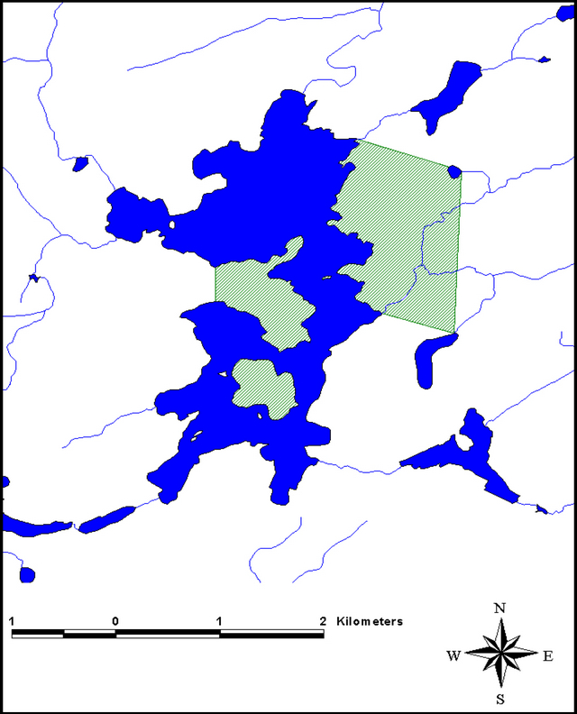
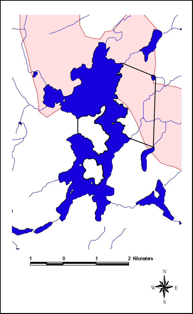
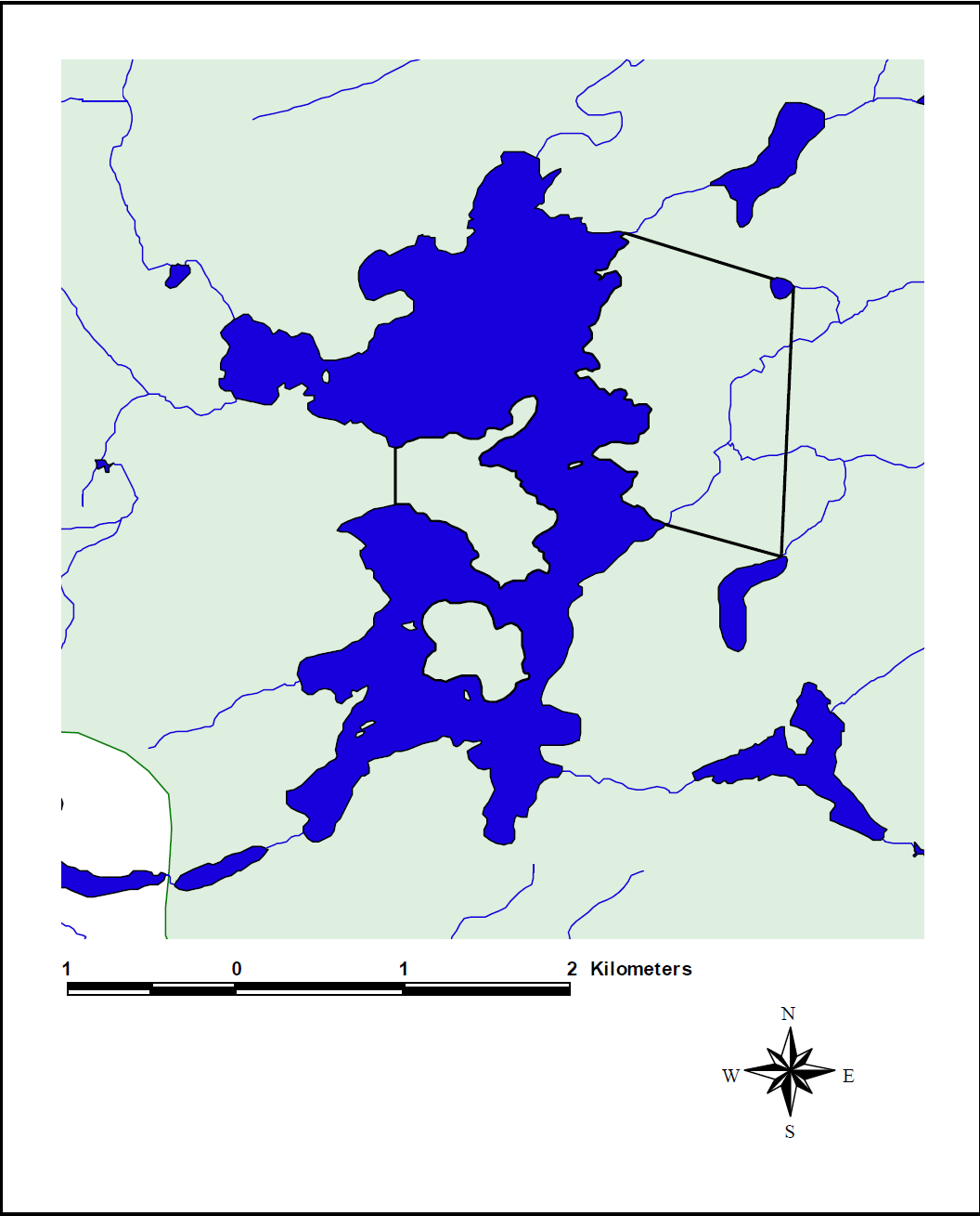
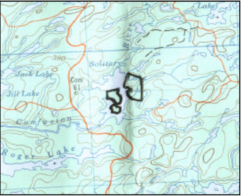
Solitary Lake Conservation Reserve is located approximately 85 kilometres north of the City of Kenora. The reserve incorporates the area adjacent to the northeastern shoreline of Solitary Lake (between two unnamed creek systems entering the lake from the east), and the peninsula on the west shore of the lake. It also includes the small island between these two areas, as well as the large island found in the southern basin of Solitary Lake. The total area to be regulated is approximately 282 hectares (OMNR, 2000a).
The intent of this Statement of Conservation Interest is to identify the natural heritage values of Solitary Lake Conservation Reserve, the activities occurring in the area and, (through a set of management guidelines), outline the activities that will be permitted and prohibited.
For more information regarding the basis of this Statement, please refer to the "Conservation Reserve Policy and Procedure PL3.03.05", specifically, pages 2-6 and 14-22 of the procedure (OMNR, 1997a).
Overview data describing Solitary Lake Conservation Reserve and location
- Name: Solitary Lake Conservation Reserve (C2362)
- Site Region/Site District: 4S-1
- OMNR Administrative Region/District/Area: Northwest/Kenora/English River
- Total Area (ha): 282 ha
- Regulation Date: Anticipated in 2002
- First Nations with Interest in Area: Grassy Narrows First Nation
- OBM: 100154110055950
- Latitude/Longutide: 50º 31' / 94º 14'
- Basemap: 505941, 505942
- FRI Stand Numbers (located partially and fully within Solitary Lake Conservation Reserve): 1164, 1861, 1454, 1753, 2763, 3159, 3263, 3071, 2876, 2575, 4471
- General Location Description: This site is located approximately 85 kilometres north of the City of Kenora.
- Access: The reserve is accessible by water and by air.
1.1 Representation targets
This section provides a summary of the earth/life science values, cultural resources, and the recreational opportunities available or possible within Solitary Lake Conservation Reserve.
| Life Science Representation | Mixed stands of aspen, birch, spruce, fir and some jack pine dominate the reserve. The majority of wetland vegetation is comprised of graminoid meadows and fens, low shrub bogs, shrub-rich treed bogs, and speckled alder (Alnus rugosa) thicket swamps (North-South Environmental, 2000b). (Refer to Section 2.1.1). |
|---|---|
| Earth Science Representation | Solitary Lake Conservation Reserve is part of the English River Geological Subprovince. The dominant rock types are metasedimentary paragneisses and migmatites (North-South Environmental, 2000a). Weakly broken bedrock plain with a discontinuous cover of silty, clay glaciolacustrine deposits dominate the topography (North-South Environmental Inc., 2000c). (Refer to Section 2.1.2). |
| Cultural Resource Representation | Nothing known at this time. |
| Recreational Opportunities | Canoeing, hunting, and fishing are the main recreational activities. |
1.2 Survey information
This section provides an overview of the inventories that were completed, their level of detail, and any further inventories that are necessary.
| Survey Level | Reconnaissance | Detailed |
|---|---|---|
| Life Science | Checklist and summary report completed by North-South Environmental Inc. Survey conducted by helicopter during September, 2000. | Not required. |
| Earth Science | Checklist and summary report completed by North-South Environmental Inc. Survey conducted by helicopter during September, 2000. | Not required. |
| Cultural | Required | Not required. |
| Recreational | Recreational assessment, Kenora staff; 2001. | Not required. |
| Other | Not required | Not required. |
2.0 Values to be protected
This section provides a description of the key natural heritage values on the site, their condition relative to past resource use and management activities, as well as their sensitivity to future land use and management activities.
2.1 Values identified on the site
2.1.1 Life sciences
Mixed forests and representative vegetation types were expected to be found in Solitary Lake Conservation Reserve (OMNR, 1999). The life science surveys identified the following life science values.
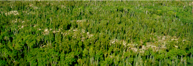
Figure 1: Black spruce stands and creek system
The forest within Solitary Lake Conservation Reserve was found to include mostly mixed stands of aspen, birch, spruce, and fir (North-South Environmental, 2000b). Black spruce stands were found intermixed among the mixed wood stands on the lower and mid-slopes. Some jack pine was found on drier sites. There was a potentially interesting sighting of a small bur oak sapling on the south shore of the peninsula within the reserve that could be regionally significant. There are also some small areas of regenerating burns.
Representative vegetation includes dwarf raspberry, red raspberry, prickly wild rose, blue bead lily, bush honeysuckle, bunchberry, twinflower, and strawberry (North-South Environmental, 2000b).
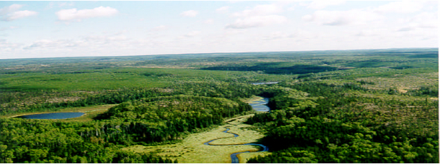
Despite the small size of the reserve, there is a high representation of biodiversity in regards to its vegetative cover (North-South Environmental Inc., 2000b). There are good examples of wetland zonation in the northeastern corner of the reserve.
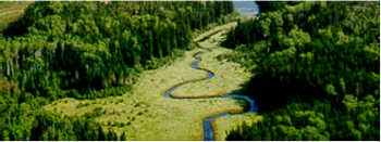
Figure 2. Creek system and wetland vegetation in the northeast corner of Solitary Lake Conservation Reserve.
2.1.2 Earth sciences
Solitary Lake Conservation Reserve was selected as a candidate for protection under Ontario’s Living Legacy because of its representative landform and vegetation types, including burns and mixed forests on organic deposits and weakly broken bedrock OMNR, 1999). The site was found to include mostly weakly broken bedrock plain with a discontinuous cover of silty, clay, glaciolacustrine deposits (North-South Environmental, 2000c).
Figure 3: Bedrock in the Solitary Lake Conservation Reserve
2.1.3 Tourism
There are no tourist establishments within the conservation reserve, however, there is one tourist outpost situated on the northwest shore of Solitary Lake, north of the reserve boundary. The lodge is owned by Wilderness Air and caters to hunters and anglers (Moorley, 2001).
2.1.4 Aboriginal values
At this time, there are no known aboriginal values within the Solitary Lake Conservation Reserve (OMNR, 1995).
2.1.5 Recreational fishing
The primary game fish in Solitary Lake are walleye, northern pike, yellow perch, whitefish, and common suckers (OMNR, 1973).
2.1.6 Cultural/historical values
At this time there are no known cultural or historical values within the Solitary Lake Conservation Reserve (OMNR, 1995).
2.1.7 Recreational hunting
Solitary Lake is part of Wildlife Management Unit # 3 and most likely includes moose, deer, and black bear, as well as other small game animals and a variety of waterfowl. The reserve is part of a Bear Management Area issued to Wilderness Air.
2.1.8 Mining
The mineral potential in the Solitary Lake Conservation Reserve is undetermined at this time. Mining is prohibited within the reserve, however, careful mineral exploration may occur within specific new conservation reserves proposed through Ontario’s Living Legacy Land Use Strategy if an area is deemed to have provincially significant mineral potential. If an area is to be developed for a mine, it would be removed from the reserve and appropriate replacement lands would be placed into regulation (OMNR, 1997a).
2.1.9 Aggregates
There is no aggregate development within the Solitary Lake Conservation Reserve (Moorley, 2001).
2.1.10 Forest harvesting
There are no immediate plans to harvest the area around or within Solitary Lake Conservation Reserve. There has been cutting in the past on the mainland in the northeast section of the reserve. This area is less than two hectares in size and is in the process of regenerating (Dawe, 2001).
2.1.11 Trapping
The reserve is part of one registered trapline. Trapping will continue to be permitted within the reserve (OMNR, 1997a).
2.2.12 Wildlife
Moose, bear, fox, wolf, deer, ducks and various other waterfowl may be found within the Solitary Lake Conservation Reserve. During the life science survey, trumpeter swans were seen in flight over the reserve, but at the present time, no evidence of a nesting site in Solitary Lake has been identified (North-South Environmental, 2000b).
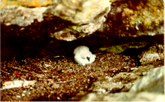
In 1981, a turkey vulture nest was found in a cave on the southwest shore of Solitary Lake (OMNR, 1981). There was one live young found within the nest. It is not known if this nest is still in use today.
2.1.13 Commercial fishing
The Solitary Lake Conservation Reserve is part of one registered baitfish area. The baitfishing rights have been allotted to Wogenstahl’s Canadian Resort and Trailer Park.
Figure 4: Young turkey vulture - Solitary Lake (1981)
2.2 Values to be protected
The intent of this Statement is to protect identified values by establishing management guidelines for existing and potential uses in this area given the level of past disturbance and the nature of the existing features.
2.2.1 Forest values
The forest values within the reserve boundaries are to be protected from any unnatural alteration (OMNR, 1999; 1997a). Successional changes associated with each forest type occurring in the area (depending on each stand’s stage of maturity, specific vegetative species composition, and soil type) are anticipated to take place as outlined in the following statements. Please note that for the purpose of this document, the successional time frame is depicted as 100 years.
The northeast mainland section of the proposed Solitary Lake Conservation Reserve has been affected by two past disturbances. In 1983, a wildfire burned through the forest surrounding the northern section of Solitary Lake. The fire completely burned through some areas and jumped over others (Zroback, 2001). Only small areas of the forest within the proposed Solitary Lake Conservation Reserve were affected (Dawe, 2001).
The primary disturbance came in 1991 when strong winds caused extensive blowdown in the forest around Solitary Lake (OMNR, 2000b). As a result of this blowdown, certain areas were harvested (Zroback, 2001). Less than two hectares of this cut-over is included within the Solitary Lake Conservation Reserve boundary (Dawe, 2001).
Figure 5: Cut-over in Solitary Lake Conservation Reserve – the easternmost boundary of the mainland section of the reserve runs down the extreme left-hand side of this cut-over
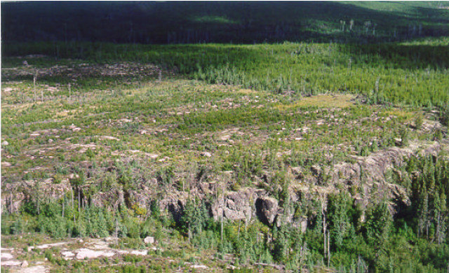
Judging from the stand ages on the 1999-2004 Forest Management Plan Map, the date of disturbance being used is the 1991 blowdown, and not the 1983 wildfire (Dawe, 2001). Even though the fire disturbance map shows the entire area to have been burned in 1983, in reality, only small pockets of fire damage are evident today within the boundaries of the proposed Solitary Lake Conservation Reserve. The blowdown within the reserve can be said to be patchy in nature as the Forest Management Plan maps show some areas within the blowdown to be only 6 years old, while adjacent stands are shown to be between 86 and 91 years old (Abitibi Consolidated, 1999).
The small area of cut-over that is included within the reserve is in the process of regenerating and is classified as a pure jack pine stand (Abitibi Consolidated, 2000). Assuming no further disturbance takes place, long-term succession will most likely be towards a more open canopy of black spruce (OMNR, 1997b).
Mixed stands of aspen, birch, spruce and fir dominate the reserve (North-South Environmental, 2000b). These stands are interspersed with black spruce and balsam fir admixtures. On the drier sites, stands of jack pine were found. There are also small areas that are in the process of regenerating from the 1983 wildfire.
In the absence of spruce budworm, the succession in the hardwood dominated stands will be toward a more open, multi-tiered, unevenly aged canopy of mixed tree species (OMNR, 1997b). The canopy cover will increase up until roughly 100 years of age and then it will begin to decline as the hardwoods fall out of the canopy. The hardwood will gradually be replaced by coniferous species such as white and black spruce, and balsam fir. Today, the stands in Solitary Lake Conservation Reserve range from 6 years of age to 91 years of age (Abitibi-Consolidated, 1999).
In the conifer-dominated stands, succession is towards a black spruce dominated stand. In areas where jack pine dominates with only the occasional black spruce, the canopy cover will decline through time. The canopy cover will remain fairly strong throughout where jack pine dominates but interspersed areas of white birch and trembling aspen do occur (OMNR, 1997b). Today, the conifer-dominated stands in Solitary Lake Conservation Reserve range from 6 to 91 years of age (Abitibi-Consolidated, 1999).
2.2.2 Recreational values
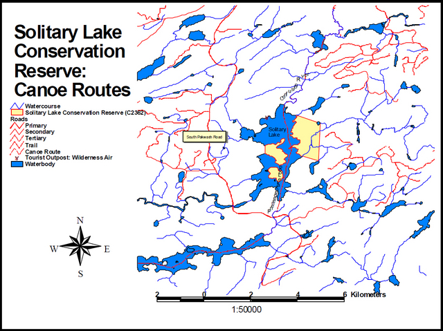
Canoeing, fishing, and hunting are the most popular recreational activities within the Solitary Lake Conservation Reserve. A canoe route flows through Solitary Lake and portages connect Solitary Lake with Confusion River in the north, and with Roger Lake in the south. Fishing opportunities exist for walleye, northern pike, yellow perch, whitefish, and common suckers (OMNR, 1973). There are hunting opportunities for moose, deer, black bear, small game, and various waterfowl.
2.2.3 Tourism values
There is one tourist outpost on Solitary Lake but it is situated just north of the Solitary Lake Conservation Reserve. The outpost is owned by Wilderness Air and caters mostly to hunters and anglers. Wilderness Air also operates one Bear Management Area within Solitary Lake and the vicinity.
3.0 Management guidelines
3.1 Land tenure
The Solitary Lake Conservation Reserve consists entirely of Crown land. No disposition by sale, Crown Lease, or Land Use Permit will be permitted within the reserve.
3.2 Existing and proposed
Development
There is an abandoned hunter’s shack located on the southern shore of the peninsula within the reserve and there is evidence of some local disturbance around the site (North-South Environmental Inc., 2000b).
There is one tourist outpost north of the reserve boundary on the western shore of Solitary Lake. No further development will be permitted in the area that would result in disturbance of the forest, including the understory.
3.3 Recreational activities
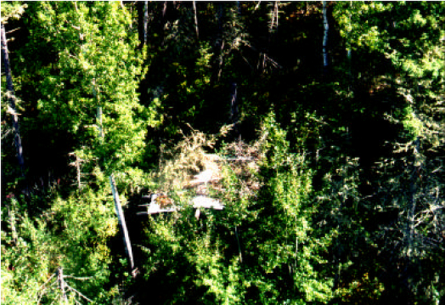
Figure 6: Overhead view of abandoned hunter’s shack
There is one canoe route that flows through Solitary Lake. It is connected to both Confusion River to the north and Roger Lake to the south via fairly extensive portages. There are also fishing opportunities within Solitary Lake for walleye, northern pike, yellow perch, whitefish, and common suckers (OMNR, 1973).
Hunting opportunities for black bear, moose, deer, and various waterfowl exist within the reserve.
3.4 Commercial activities
Trapping will continue to be permitted within the reserve boundary as the area forms part of a registered trapline (OMNR, 1999). Black bear hunting will also continue to be permitted since the reserve is part of one Bear Management Area. The reserve is also part of a registered baitfish operation. No changes to these areas are required at this time provided that they do not impact the reserve’s identified and protected natural heritage values. No further commercial activities will be permitted in the area, including road construction, removal of aggregates, and development of utility corridors (OMNR, 1999; 1997a).
The area has been permanently removed from the operable Whiskey Jack Forest Land Base and withdrawn from all mining exploration and extraction activities by the Ministry of Northern Development, Mines and Forestry (MNDMF) at the MNR’s request.
3.5 Aboriginal interests
Solitary Lake Conservation Reserve is located within a primary interest area of the Grassy Narrows First Nation. Any specific aboriginal values associated with the reserve are unknown at this time although they may be identified during First Nation consultation. However, nothing in this Statement of Conservation Interest will affect existing or future aboriginal or treaty rights. No boat cache permits, baitfish licenses, traplines, or Bear Management Areas are allotted to members of the Grassy Narrows First Nation.
3.6 Natural Resources Stewardship
3.6.1 Vegetation management
The Forest Fire Management Strategy for Ontario (OMNR 2004) places Solitary Lake Conservation Reserve in the boreal zone providing the same level of protection from fire as the surrounding forest. Should natural large-scale disturbances (forest fires, blow downs) not take place, the vegetation will mature through successional processes as outlined in section 2.2.1.
Fuelwood permits will not be issued within the area encompassed by the Solitary Lake Conservation Reserve. However, usage of the areas wood resource for shorelunches and campfires will be permitted provided that there will be no resulting damage or alteration of the forest and its understory (OMNR, 1997a).
3.6.2 Fish and wildlife
Management
No management action is required other than the implementation of existing Wildlife Management Unit # 3 regulations, sport fishing regulations and management activities.
Solitary Lake Conservation Reserve – Statement of Conservation Interest 15
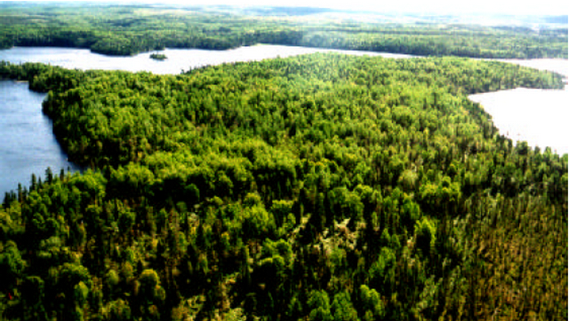
Figure 7: Solitary Lake Conservation Reserve - (peninsula)
3.6.3 Landforms
The landforms represented within Solitary Lake Conservation Reserve will not be altered through any landform modification activities, including filling and extraction of aggregates, peat, soils, and similar materials (OMNR, 1997a).
3.7 Cultural Resources Stewardship
Based on existing information, there are no requirements at this time.
3.8 Client services
Information regarding this conservation reserve will be made available so as to ensure that all resource users (particularly forestry and mining companies) are aware of its location, recognized values, and permitted uses. Potential users include tourists, local anglers/hunters, recreationalists (ie. canoeists, hikers, snowmobilers), and the general public, all of who may utilize the areas wood resource for camping, shorelunches, firewood, and personal use.
3.9 Research
Non-destructive research relating to cultural and historical values within the reserve would be beneficial so as to add further potential values to the reserve, as well as to ensure their protection. Further research into the possibility of a trumpeter swan nesting site, as well as a verification of the existence of the turkey vulture nesting site would also be very beneficial as their existence would add even more regional significance to the conservation reserve.
3.10 Marketing
There are no marketing requirements at this time.
4.0 Implementation
These management guidelines will be implemented immediately by Kenora District. Any MNR Resource Management Plans or Land Use Plans which include this area will be amended accordingly. Any affected clients will be immediately informed of amendments to this management direction. Administrative responsibility for the conservation reserve rests with the Planning and Information Management Supervisor. Implementation will primarily involve monitoring activities to ensure adherence to the management guidelines.
5.0 Review and revisions
5.1 Review and revisions
Methods of reviewing management direction will be consistent with the Protected Areas Planning Manual (OMNR 2009) and its associated guidelines. In accordance with the Provincial Parks and Conservation Reserves Act 2006, MNR will annually examine management direction documents that have been in place for ten years or more. The next scheduled examination for Solitary Lake Conservation Reserve will be in 2020.
5.2 Public consultation
5.2.1 Results of past consultation
Contact regarding the regulation of Solitary Lake Conservation Reserve was made with timber companies, local communities, and the general public in August, 2000. Consultation efforts involved the direct mailing of a District information package to local interest groups (such as the Local Citizens Committee), as well as to all those with patent land, boat caches, bear management areas, trapline areas, baitfishing areas, and Sustainable Forest Licenses within and/or adjacent to the reserve’s proposed boundaries. In addition, an interview was held on CJRL radio in Kenora and newspaper advertisements were issued in the Kenora Enterprise and the Kenora Daily Miner and News in mid-August, 2000. Only a few responses were received and were specifically related to activities permitted and prohibited within this conservation reserve.
First Nation consultation associated with Solitary Lake Conservation Reserve occurred.
5.2.2 Present and future consultation
Other than the completion of First Nations consultation, more widespread consultation is not deemed necessary at this time due to the extensive consultation which took place in August, 2000 (refer to section 5.2.1).
6.0 References
Abitibi Consolidated. 1999. 1999-2004 Forest Management Plan Map, Basemap #41559.
Anderson, Dave. 2001. Area Forester. Personal Correspondence. OMNR, Kenora District.
Dawe, Mike. 2001. Senior Forest Specialist. Personal Correspondence. OMNR, Kenora District.
Moorley, Rob. 2001. Resource Management Technician. Personal Correspondence. OMNR, Kenora District.
North-South Environmental Inc. 2000a. Earth and Life Sciences Reconnaissance Survey. 14 Provincial Parks and Conservation Reserves in the Western Part of Northwestern Ontario: Summary Report to the Earth and Life Science Checksheets.
North-South Environmental Inc. 2000b. Life Science Checksheet – Solitary Lake Conservation Reserve.
North-South Environmental Inc. 2000c. Earth Science Inventory Checklist – Solitary Lake Conservation Reserve.
Ontario Ministry of Natural Resources. 1973. Solitary Lake Survey File.
Ontario Ministry of Natural Resources. 1981. Solitary Lake Survey File.
Ontario Ministry of Natural Resources. 1995. Kenora District Archaeological Sites – Maps 52L/8 & 52L/9.
Ontario Ministry of Natural Resources. 1997a. Conservation Reserves Policy and Procedure. PL 3.03.05.
Ontario Ministry of Natural Resources. 1997b. Silvicultural Guide to Managing for Black Spruce, Jack Pine and Aspen on Boreal Forest Ecosites in Ontario. Book II: Ecological and Management Interpretation for Northwest Ecosites. Version 1.1 September, 1997.
Ontario Ministry of Natural Resources. 1999. Ontario’s Living Legacy Land Use Strategy.
Ontario Ministry of Natural Resources. 2000a. Ontario’s Living Legacy Fact Sheet - Solitary Lake Conservation Reserve (C2362).
Ontario Ministry of Natural Resources. 2000b. Kenora District-Kenora & Whiskeyjack Forests Wildfire/Blowdown History Map (200 + Ha).
Ontario Ministry of Natural Resources. 2004. Forest Fire Management Strategy for Ontario. Queen’s Printer for Ontario, Toronto. 64 pp.
Ontario Ministry of Natural Resources. 2009. Ontario Protected Areas Planning Manual. Peterborough. Queen’s Printer for Ontario. 50 pp.
Provincial Parks and Conservation Reserves Act. 2006. Toronto. 44 pp. [online]
Zoltai, S.C. 1960. Ontario Department of Lands and Forests. Surficial Geology – Map of Kenora – Rainy River.
Zroback, Fred. 2001. Resource Management Technician. Personal Correspondence. OMNR, Kenora District.
Appendix A: Map of SCI sites within Kenora District
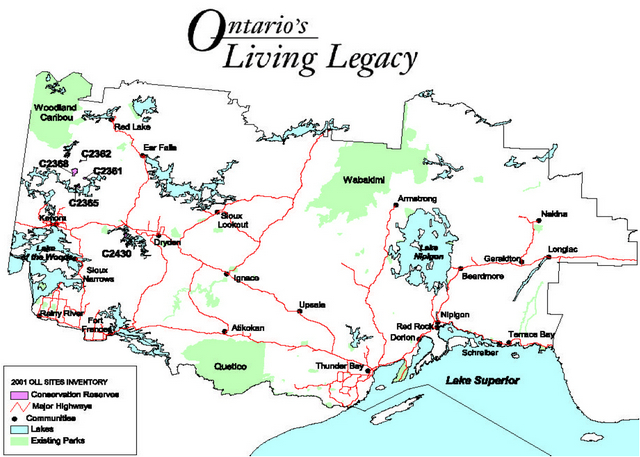
Enlarge Appendix A: Map of SCI sites within Kenora District
Appendix B: Solitary Lake conservation Reserve
Enlarge Appendix B: Solitary Lake conservation Reserve
Appendix C: Solitary Lake Conservation Reserve: Roads and routes
Enlarge Appendix C: Solitary Lake Conservation Reserve: Roads and routes
Appendix D: 1983 Forest fire map

Enlarge Appendix D: 1983 Forest fire map
Appendix E: 1991 Blowdown Map

Enlarge Appendix E: 1991 Blowdown Map
Appendix F: Life Science Checksheet
Natural heritage area – Life Science Checksheet
| Name | Solitary Lake Conservation Reserve C2362 |
|---|---|
| Map Name | Sydney Lake |
| Map Number | 52 I/09 |
| UTM Ref: | 412750 5597000 |
| County | Unorganized Area |
| Latitude | 50 31' |
| Longitude | 94 14' |
| NAD | 83 |
| Minimum Altitude | 340 |
| Maximum Altitude | 360 |
| Locality | Unorganized Area |
| Township | Unorganized Area |
| Area | 282 ha |
| Ownership | Crown Land |
| MNR Region | Northwest |
| Ecoregion and Ecodistrict | 4S1 |
| Landform Unit(s) | See attached table |
| MNR District | Kenora |
| Aerial Photographs Year – Roll – Flight Line - Numbers |
Physical and biological features
Representation
This, one of the smallest reserves, contains mostly mixed stands of aspen, birch, spruce and fir. Interspersed within mixedwoods, especially as fringe communities on lower and mid-slopes are black spruce stands, often with admixtures of balsam fir. Other coniferous types, generally on drier sites include Jack pine stands. Small areas of regenerating burns are also present. Wetlands occur in the mainland portion of the reserve. These include graminoid meadows (Calamagrostis canadensis), graminoid fens (Carex lasiocarpa, Carex utriculata), poor fens (Chamaedaphne calyculata, Sphagnum), shrub-rich treed fens (Chamaedaphne calyculata, Ledum groenlandicum, Sphagnum), and Alnus rugosa thicket swamps.
Condition
The reserve is composed of communities mostly unaffected by man’s activities. An old, apparently abandoned, hunter’s shack still stands on the south shore of the peninsula. Some local disturbance is evident in its vicinity. The small size of the reserve makes it vulnerable to outside sources of impact (e.g. potential logging in proximity, especially on a large scale, associated impacts on water quality). Logging regime should be preferably "staggered", with cuts occurring along small sections and over a number of years in order to supply differently aged stands on a continuous basis. The reserve’s configuration as three small separate pieces prevents the linkage between the components. The preferred shape would be to join the three parts and form one contiguous entity.
Diversity
The reserve, despite its small size, exhibits a relatively high level of biodiversity in its vegetation cover. Good examples of zonation in wetlands are observed in the northeastern corner.
Ecological considerations
A considerable range of habitats in the reserve supports a diversity of plant species. The reserve protects several small peninsulas extending into Solitary lake, protecting linkages between uplands an lakes and potential narrow shoreline wetlands.
Special features
A potentially interesting floristic sighting is a small (1.6 m) bur oak sapling encountered 40 m N of the south shore of the peninsula (approx. 411675E, 5596200N).
Major information sources
Field survey (September 2000)
Significance level (provincial/regional/local) and brief summary of major representative values
Local significance because of the wetland diversity, and the bur oak presence.
Date Compiled:
November 2000
Compiler:
Christopher Zoladeski, North-South Environmental Inc.
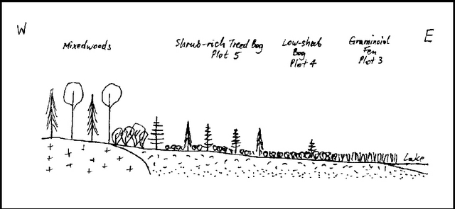
Image 1: Hand drawn image showing different kinds of mixedwood and shrubs separated by plot areas.
Solitary Lake Conservation Reserve
Plot 1: 411676E 5596213N
Description: Open mixedwood. Many canopy gaps due to blowdowns. Shrub-rich. Representative of the whole peninsula and the island.
Composition:
T: Populus tremuloides 3, Picea mariana 2, Betula papyrifera 2
TS: Acer spicatum 3, Picea mariana +, Corylus cornuta 2, Populus tremuloides 1
LS: Diervilla Lonicera 2, Rubus idaeus +, Betula papyrifera 1, Rosa acicularis +, Rubus pubescens 1, Abies balsamea +
H: Linnaea borealis 2, Carex sp. 1, Viola renifolia +, Galium triflorum +, Pyrola asarifolia 2, Cornus canadensis 1, Fragaria virginiana +, Clintonia borealis 1, Lathyrus ochroleucus +
M-L: Brachythecium spp. 1, Rhytidiadelphus triquetrus +, Petasites palmatus +
Other vegetation communities:
One small (1.6 m) Quercus macrocarpa sapling seen near S shore (ca. 40 m north of the shore) of the peninsula. Small colonies of Eleocharis palustris in deep water along S shore.
Other notes:
Two swans (unidentified) seen in flight. Old hunter’s cabin on S shore.
Plot 2: 413298E 5597999N
Description:
Wet Calamagrostis meadow along the fringe of the bog.
Composition:
LS: Alnus rugosa +, Rubus idaeus +
H: Calamagrostis canadensis 5, Vicia americana +
Plot 3: 413366E 5597856N
Description:
Sedge fen. Very hummocky, soft substrate, numerous water pools. Forms a 5-10 m wide zone along the lake’s edge.
Composition:
LS: Chamaedaphne calyculata +, Larix laricina p
H: Carex lasiocarpa 3, Triadenum Fraseri +, Carex utriculata 2, Epilobium sp. +, Potentilla palustris 1
M-L: Sphagnum sp. 3
Plot 4: 413342E 5597873N
Description: Poor fen. Chamaedaphne forms a continuous layer, 30 cm tall. Scattered stunted (2-3 m) spruce and tamarack. Continuous peat moss on the ground. Ground hummocky, but firming up, surprisingly not very wet considering the wet summer.
Composition:
LS: Chamaedaphne calyculata 4, Larix laricina +, Ledum groenlandicum 1, Vaccinium Oxycoccos +, Picea mariana +, Kalmia polifolia +
H: Smilacina trifolia 2, Scirpus hudsonianus +, Carex sp. +
M-L: Sphagnum spp. 5
PLOT 5: 413256E 5597917N
Description: Shrub rich treed bog. Chamaedaphne and Ledum 30-40 cm, with stunted black spruce and tamarack. Hummocks of Sphagnum. Ground spongy but firm when standing Wet-mesic site.
Composition:
TS: Picea mariana 2, Larix laricina 2
LS: Chamaedaphne calyculata 3, Larix laricina +, Ledum groenlandicum 2, Vaccinium Oxycoccos +, Picea mariana +, Kalmia polifolia +
H: Scirpus hudsonianus +, Smilacina trifolia +
M-L: Sphagnum spp. 5, Cladina rangiferina +
Appendix G: Earth Science Inventory Checklist
Earth Science Inventory Checklist
Name: Solitary Lake Conservation Reserve
OLL ID: C2362
Map Name: Sydney Lake
NTS Number: 52 L/09
UTM Reference: 412750 5597000
OBM Number:
Latitude: 50 31'
Longitude: 94 14'
Elevation – Maximum: 360
Elevation – Minimum: 340
County: Unorganized Area
Township: Unorganized Area
Lot Unorganized Area
Concession: Unorganized Area
Area (ha): 282.00
Ownership:
Crown Land:
Aerial Photographs (Year – Roll – Flight Line – Numbers):
MNR Region: Northwest
MNR District: Kenora
Park Zone: Northwest
Map of Solitary Lake Conservation Reserve
Earth science features
- English River Sub-province (Precambrian Canadian Shield)
- metamorphosed sedimentary rocks (paragneisses and migmatites)
- Late Wisconsinan till ground moraine deposits (very minor)
- Glacial Lake Agassiz silty clay deposits
- Holocene peat deposits
Representative landform complexes in this reserve include:
- Weakly broken bedrock plain with discontinuous cover of silty clay glaciolacustrine deposits; and
- Flat organic deposits in terrestrializing
Significance
Low overall bedrock geology and surficial geology significance.
Some significance relating to presence of glacial Lake Agassiz deep basin sediments.
Sensitivity
Low sensitivity to most uses, however, potential erosion of silty clay deposits on western peninsula if forest cover is cleared.
Recommendations
None
Major references
North-South Environmental Inc. 2000. Summary Report of the Reconnaissance Surveys
Field work undertaken on September 30, 2000.
Date compiled
November 30, 2000
Compiler
Daryl W. Cowell, North-South Environmental Inc.
Solitary Lake Conservation Reserve
Field work completed: September 30, 2000
This reserve was identified under the provincial Lands for Life – Ontario’s Living Legacy Program. It was principally identified for its life science representation with no previous earth science significance assigned.
No earth science features or landform complexes of particular significance were found in this reserve. The summary report prepared in conjunction with this checklist provides an overview of the bedrock geology and surficial geology history and representation of this reserve and should be consulted for more information (North-South Environmental Inc. 2000). Detailed site information collected during the reconnaissance field surveys is provided on the attached table and in the accompanying site photgraphs. A map of the surficial geology also accompanies this checklist (prepared from Northern Ontario Engineering Geology Terrain Study Maps 5105 and 5106).