Stuart Lake Wetland Conservation Reserve Management Statement
This document provides policy direction for the protection, development and management of the Stuart Lake Wetland Conservation Reserve and its resources.
Statement of Conservation Interest (SCI)
Ministry of Natural Resources
Algoma Area
Sault Ste. Marie District
February 14, 2003
Ce document est seulement disponsible en anglais.
Sault Ste. Marie District
Ministry of Natural Resources
Approval statement
I am pleased to approve this Statement of Conservation Interest (SCI) for the Stuart Lake Wetland Conservation Reserve (C262).
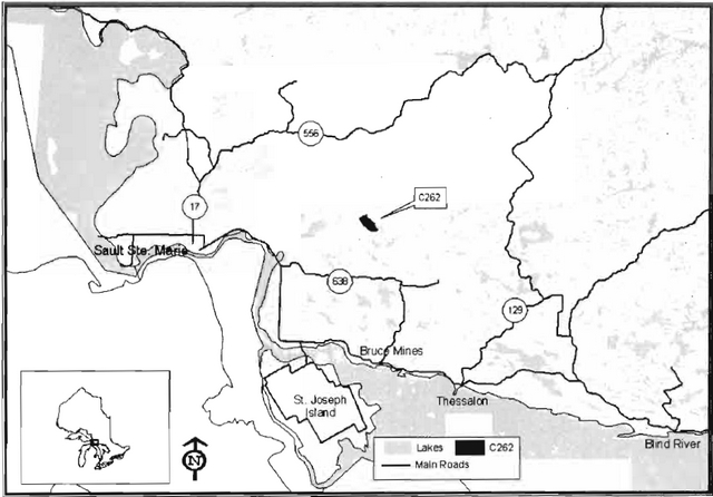
The Stuart Lake Wetland Conservation Reserve captures a long narrow wetland surrounded by steep bedrock-controlled ridges. It offers the best example of sugar maple (Acer saccharum Marsh.), balsam fir (Abies balsamea), white birch (Betula papyrifera Marsh.), yellow birch (Betula alleghaniensis) and white cedar (Thuja occidentalis L.) growing on steep hills of glacial till and bedrock. Regulated on April 6, 2001, this 661-hectare conservation reserve is approximately 30 km north of the Town of Bruce Mines and is located in the Territorial District of Sault Ste. Marie, in Northeastern Ontario.
Direction for establishing, planning and managing conservation reserves is defined under the Public Lands Act and current policy. The direction for managing this conservation reserve is in the form of an SCI, which defines the area that is being planned, provides the purpose for which the conservation reserve has been proposed, and outlines the Ministry of Natural Resources' intent for the protected area. This SCI will provide both guidance for the management of the conservation reserve and the basis for ongoing monitoring of activities. More detailed direction at this time is not anticipated. However, should significant facility development be considered or complex issues arise requiring additional studies, more detailed management direction in the form of special protection measures, or a detailed Resource Management Plan will be prepared with full public consultation.
Public and Aboriginal consultation occurred prior to the regulation of this conservation reserve during the planning for Ontario’s Living Legacy (OMNR 1999). Furthermore, there was a 15-day review period in January 2002 concerning a draft of this SCI. Comments from the review period have been considered in the development of this document.
This SCI will be implemented by the Algoma Area Supervisor, and will be reviewed every five years and amended as required by the District Planner, Sault Ste. Marie District, Ministry of Natural Resources.
Submitted by: Erin Nixon
Date: February 21, 2003
Recommended
For Approval by:
Serge Tenaglia, R.P.F.
District Manager
Sault Ste. Marie District
Date: March 4, 2007
Approved by:
Rob Galloway
Regional Director
Northeast Region
Date: May 30, 2003
1.0 Introduction
The following document is a Statement of Conservation Interest (SCI) for the Stuart Lake Wetland Conservation Reserve (C262). The purpose of this SCI is to identify and describe the natural, recreational and cultural values of Stuart Lake Wetland Conservation Reserve and to outline the Ministry of Natural Resources' management intent for this area. The first portion of this document highlights the provincial context in which it was produced, states its goals and objectives and summarizes the planning process for conservation reserves. The remainder of this document specifically addresses the Stuart Lake Wetland Conservation Reserve.
Management direction provided within this SCI will serve to protect the conservation reserve for the benefit of all Ontario residents. This direction will comply with the land use intent stated in the Ontario’s Living Legacy Land Use Strategy (OMNR 1999).
1.1 Provincial context
Ontario’s network of natural heritage areas has been established to protect and conserve areas representative of the diversity of the natural regions of the province, including species, habitats, features and ecological systems which comprise that natural diversity. Protected natural heritage areas are a key component in the sustainable management of natural resources. They ensure that representative sites within the larger managed landscape are permanently retained in their natural state. The Stuart Lake Wetland Conservation Reserve is part of Ontario’s network of natural heritage areas.
On July 16, 1999, the Ontario Government released the Ontario’s Living Legacy Land Use Strategy to guide the planning and management of Ontario’s Crown lands. Extensive consultation was conducted during the development of the Land Use Strategy. The objectives of the Land Use Strategy (OMNR 1999) are to complete Ontario’s system of parks and protected areas; recognize the land use needs of the resource-based tourism industry; provide forestry, mining and other resource industries with greater certainty around land and resource use; and enhance hunting, angling and other Crown land recreation opportunities.
The Land Use Strategy (OMNR 1999) demonstrated the government’s commitment to completing Ontario’s system of protected natural heritage areas by designating 378 new areas to be protected. These areas are considered to be significant and require protection from incompatible activities in order for their values to endure over time. The addition of these 378 new areas marks the largest expansion of parks and protected areas in Ontario’s history. The Stuart Lake Wetland Conservation Reserve was created as part of this expansion.
The Ministry of Natural Resources has established conservation reserves as a tool to protect natural heritage areas on public lands, while permitting traditional public land uses to continue. These uses include recreational activities, such as hunting and fishing, and the traditional activities of Aboriginal societies as defined in applicable Aboriginal Treaties. Lands designated as conservation reserves in the Land Use Strategy (OMNR 1999) are removed from the Sustainable Forest Licence, and mining and surface rights are withdrawn from staking under the Mining Act (RSO 1990 Chapter M.14).
Ontario’s Living Legacy Land Use Strategy (OMNR 1999) outlines the general land use policy and management direction for new conservation reserves. Each new conservation reserve will have a planning document, either a SCI or, in more complex situations, a Resource Management Plan, that details site-specific management direction.
2.0 Goal and objectives of the SCI
2.1 Goal
The goal of this SCI is to provide the framework and direction to guide management decisions affecting the Stuart Lake Wetland Conservation Reserve.
2.2 Objectives
The following objectives are identified as the means to achieve the above stated goal.
- To describe the state of the resource with respect to the values mentioned in Section 5.0 and the current land use activities.
- To outline the Ministry of Natural Resources' management intent for the protected area.
- To determine the land use compatibility of current land uses, and to develop specific guidelines and prescriptions to manage these uses.
- To create public awareness of the values within this conservation reserve by providing information on the resources that it contains and protects; and to promote responsible stewardship of the protected area through partnerships with local stakeholders.
- To determine the long-term management goals for the conservation reserve by identifying research, client services, and marketing strategies necessary to position this conservation reserve among the system of parks and protected areas in Ontario.
- To identify the scientific values on the site in relation to provincial benchmarks and identify the necessary monitoring and/or research to maintain the integrity of those values.
- To provide direction for the evaluation of proposed new uses or economic ventures through the application of the Test of Compatibility (Appendix A). This test will evaluate the impact of suggested use(s), either positive or negative, on the protected values of the conservation reserve.
3.0 Management planning
3.1 Planning for a conservation reserve
The planning process for a conservation reserve consists of defining site boundaries and preparing a site specific management plan. Public, Aboriginal and industry consultations occur during the planning process. When the boundaries of the site are finalized and the Ministry of Natural Resources' approval process is complete, a conservation reserve becomes regulated. Once a conservation reserve is regulated, the level of management planning required to fulfill the protection targets is determined, and either a basic or an enhanced SCI or a Resource Management Plan is prepared. A basic SCI is prepared when no new decisions are made beyond those mentioned in the Ontario’s Living Legacy Land Use Strategy (OMNR 1999), whereas an enhanced SCI is prepared when one or more decisions are made beyond those mentioned in the Strategy. A Resource Management Plan is prepared in more complex situations where a number of issues have to be addressed. Whichever the determination, the plan must be completed within three years of the conservation reserve’s regulation date. The guidelines for the preparation of these documents are provided in Procedural Guideline A- Resource Management Planning (Conservation Reserves Procedure PL3.03.05, Public Lands Act).
A SCI is essentially a management plan based on the management direction provided in the Land Use Strategy (OMNR 1999). The purpose of a SCI is to identify the state of the resource with respect to the site’s values (Section 5.0) and current land use activities, and to outline the Ministry’s management intent for the conservation reserve. Basic SCI's typically go through a public review period of 15 days. Upon completion of this public review, the SCI is revised as appropriate and approved by the Ministry of Natural Resources' Regional Director.
Existing permitted uses within conservation reserves may continue, unless they are shown to have a significant negative impact on the values protected by the site. A review/evaluation mechanism is in place to address proposed new permitted uses, or land use proposals. The Test of Compatibility as outlined in the Public Lands Act Policy PL 3.03.05 (OMNR 1997) and/or other standard OMNR environmental screening processes, is used to screen future proposals. Where cultural resources may be impacted, proposals may be screened through Conserving a Future for our Past: Archaeology, Land Use Planning & Development in Ontario, Section 3 (MCzCR 1997), in a manner similar to that used by the Ministry of Natural Resources in the forest management planning process.
Public comment may be solicited during a review of any future land use proposals that require new decisions to be made. Appropriate environmental assessment (EA) requirements and amendment processes will apply to any future proposal and/or any significant change in management direction being considered for a site.
3.2 Planning process for the Stuart Lake Wetland Conservation Reserve
Stuart Lake Wetland Conservation Reserve (C262) was proposed as a conservation reserve in the 1999 Ontario’s Living Legacy Land Use Strategy by the Ontario Ministry of Natural Resources. Public, Aboriginal and industry consultation has taken place and the boundary of the site has been finalized. The site was formally regulated through an amendment to Ontario Regulation 805/94 of the Public Lands Act on April 6th, 2001, by Ontario Regulation 86/01.
To date, no significant issues related to land use in this area have been identified. For this reason, it was determined that a basic SCI will adequately identify the conservation reserve’s significant features and address the management guidelines for this conservation reserve. Therefore, the Stuart Lake Wetland Conservation Reserve will be managed under the auspices of a SCI. It should be noted that this SCI addresses only those issues or land use proposals currently known to the District Manager. The direction provided by this SCI, and future management decisions, will resolve any future land use conflicts and will ensure that identified values continue to be adequately protected.
3.2.1 Planning area
The planning area for this SCI consists of the regulated boundary for the Stuart Lake Wetland Conservation Reserve (see Section 10, Map 1). However, to fully protect values within the conservation reserve, additional consideration within larger land use planning initiatives may be required. The forest management planning process is an example of how adjacent land management may consider sensitive features within the conservation reserve boundary.
3.3 Guiding principles
All current or planned activities within this conservation reserve will be in compliance with the following guiding principles. If a conflict between management guidelines exists, the following guiding principles will be used to discern management intent and resolve the issue.
- All management guidelines will be based on maintaining the long-term ecological integrity of the area.
- No new or existing uses will be permitted if it is deemed the protected values (identified in Section 5.0) will be compromised.
- All attempts will be made to maintain traditional uses while protecting the values (Section 5.0) and maintaining the long-term ecological integrity of the site.
- This conservation reserve was chosen to represent vegetation and landscape types unique to this site district and Ontario. All efforts will be made to maintain the values identified in Section 5.0.
- Overall, management strategies will focus on maintaining the conservation reserve in as natural a state as possible.
4.0 Background information
4.1 Location and site description
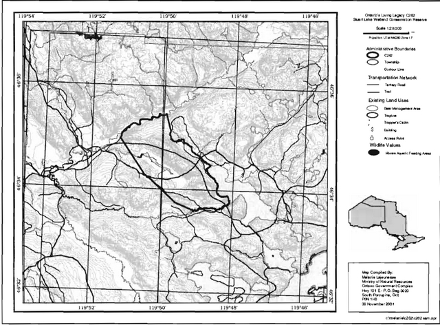
Stuart Lake Wetland Conservation Reserve is located approximately 30 km due north of the Town of Bruce Mines and encompasses much of the west shore of Stuart Lake in McMahon and Chesley Additional Townships (Figure 1). The conservation reserve is relatively inaccessible.
The following table describes the location and administrative details of the site:
Table 1: Location and administrative details for the Stuart Lake Wetland Conservation Reserve
| Name | Stuart Lake Wetland Conservation Reserve |
|---|---|
| Site Region - Site District (Hills) | 5E Georgian Bay 5E-1 Thessalon |
| Site region - Site District (Crins and Uhligl | 5E-1 |
| Ministry of Natural Resources Administrative Region/District/Area | Northeast Region/Sault Ste. Marie District/Algoma Area |
| UTM co-ordinates | 283175 E 5161761 N Zone 17 |
| SCI Completed | February 14, 2003 |
| Regulated | April 6 2001 |
| Area | 661 ha |
| Nearest Town/Municipality | Approximately 30 km north of the Town of Bruce Mines |
| Township(s) | McMahon Chesley Additional |
| OBM Numbers | 2017280051600 |
| Topographical Map Name/Number | 41 J/12 Echo Lake |
| Wildlife Management Unit | WMU# 36 |
| Forest Unit | Algoma Forest |
4.2 History of the site
Abandoned logging roads traverse the eastern and southern edges of the conservation reserve (Section 10.5). The location of these logging roads, the forest age class and the inoperability of much of the terrain shows that harvesting of this area was limited to the less precipitous lands surrounding the wetland and hills of this conservation reserve. It is estimated that harvesting has not occurred for more than 80 years within the boundaries of this conservation reserve. The regenerated forest is now characterized by mature, predominantly pure stands of sugar maple.
Evidence of fire can be found on some of the ridge tops within this conservation reserve. Lightning likely caused these fires; however, there are no records to substantiate this claim.
Aerial and field reconnaissance surveys carried out in 2000-2001 form the basis for the description of the site’s values.
4.3 Inventories
Table 2 indicates the current status of natural heritage inventories that have occurred and/or are required for the Stuart Lake Wetland Conservation Reserve.
Table 2: Inventory and Survey Information for the Stuart Lake Wetland Conservation Reserve
| Survey Level | Earth Science | Life Science | Cultural | Recreational |
|---|---|---|---|---|
| Reconnaissance | 2000 | 2000 | 2000 | 2000 |
| Detailed | Not required | 1998 Bergsma | Not required | Not required |
| Further requirements | Future ground surveys could be considered to enhance knowledge of life science values | All access points, trails and roads should be identified and mapped by GPS. |
5.0 State of the resource
The key values (geological features and/or featured species) found within Stuart Lake Wetland Conservation Reserve include the following;
- The best provincial examples of sugar maple, balsam fir, white birch, yellow birch and white cedar growing on steep hills of glacial till and bedrock;
- A long, narrow wetland surrounded by steep, bedrock-controlled ridges.
The key values are those values that make this site unique and have led to its designation as a conservation reserve. Their protection is paramount. Additional values as listed in Section 5.1 through to Section 5.5 are also important. This description is not necessarily complete. If new values are identified, they will be added to this section. If any new value is considered significant, management guidelines may be modified, if required, to ensure its protection.
5.1 Earth sciences
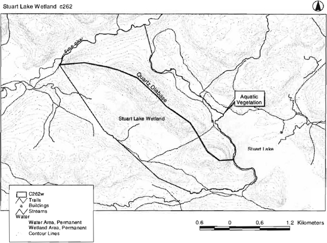
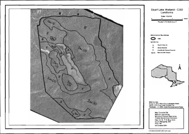
Stuart Lake Wetland Conservation Reserve is located at the northern limit of Site District SE 1, which is characterized by very strongly broken, shallow sandy till uplands. This conservation reserve contains one of the headwater areas for the Echo River system that flows to Lake George. A series of high rock ridges of quartz diabase run approximately through the center of the site in a northwest to southeast direction. Gowganda metasediment formations and Lorrain quartzile formations resulting in steep to moderate relief flank the rock ridges. The central ridge consists of a moderate relief in the north, a rockier slope in the northeast, and magnificent overhanging cliffs with extensive talus in the southeast. Southwest of the large wetland complex, two additional rock knob areas are present with mainly sugar maple and a predominately deciduous community located on the northern most landform. A diverse array of species such as poplars, maples, birches and eastern hemlock occurs on the southern hill (Thompson et al. 2002).
This site contains landform types dominated by strongly and moderately broken ground moraine, with lacustrine deposits recorded in the northwest corner (Thompson et al. 2002, OFRI 1994 data). Two biophysiographic units were described for the site, with strongly broken uplands of sand and till (bedrock) dominating, and the presence of weakly broken outwash plain along the Echo River within the most northern portions of the conservation reserve (Thompson et al. 2002). Refinement of landforms was based on the aerial reconnaissance survey conducted by Arnup (2000) and aerial photo interpretation. The site was found to contain four landform types: 1) bedrock drift complexes of discontinuous drift cover and predominately till deposits that form the dominant ridges within the site; 2) glaciofluvial deposits located within cooler ravines and bottom lands; 3) alluvial deposits generally associated with Letz Creek and Echo River systems; and, 4) organic deposits dominate the large wetland complex that runs basically northwest to southeast (Thompson et al. 2002).
A total of 29 separate forest communities and six wetland types were identified. The magnificent topography with the juxtaposition of undisturbed rock ridges, cliff and talus complexes, ravines, bottomlands and wetlands with the existence of the shallow, gravel substrate in Echo River all contribute to the site’s representative values and overall beauty (Thompson et al. 2002).
5.2 Life sciences
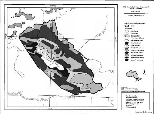
The Stuart Lake wetland is defined as a meadow marsh with components of an open fen. The marsh contains areas of open, slow moving water bordered by a fen containing a thick organic layer composed mainly of sphagnum moss with a small component of black spruce. These very wet areas are surrounded by a thicket swamp containing pockets of standing water and a dense understory of alder (Alnus sp.), mountain maple (Acer spicatum Lamb.) and willow (Salix sp. L). Cedar is interspersed throughout the swamp, along with black spruce (Picea mariana (Mill.) BSP), balsam fir, tamarack (Larix laricina (Du Roi) K. Koch) and hemlock (Tsuga canadensis) in the overstory.
The majority of the upland areas of this conservation reserve are composed of mature to old growth sugar maple stands, with small components of yellow birch and hemlock present. These trees are dense, forming a closed canopy in the overstory. The understory is composed mainly of shade tolerant to intermediately tolerant saplings such as sugar maple, yellow birch, white birch and hemlock. Although it contributes to the aesthetic qualities of this conservation reserve, this forest type is not unique and occurs commonly in the surrounding forests.
The areas of high relief consist of exposed bedrock and a sparser stand structure. The stands consist of even-aged, mixed-wood forests, composed mainly of white birch, red maple, balsam fir, red oak and white pine. The stands range from 60 to 80 years of age, and the trees are often small, stunted and windswept. The southeastern hill contains some pockets of pure white pine and pure red oak which, seen from Stuart Lake, offer an impressive sight. Due to the uniform age of the stands and observed fire scars, it is likely that the upland forests are of fire origin.
The Echo River defines the northern boundary and drains into Echo Lake, which is located west of the conservation reserve. The Stuart Lake wetland also drains into this lake and performs important hydrological functions such as filtering sediments and maintaining constant water levels on Echo Lake (OMNR, 1993).
Abundant aquatic vegetation was observed in the small riparian wetland located on the north tip of Stuart Lake within the conservation reserve. This wetland, along with downed woody debris observed along the portion of lake shoreline within the conservation reserve (Section 11.0), provide habitat for resident fish species, wading birds and waterfowl.
This site has additional life science value due to the presence of the adjacent Stuart Lake. Stuart Lake contains pike (Esox lucius), cisco (Corgonus artedii) and small mouth bass (Micropterus dolomieui). It was stocked at various times since 1930 with brook trout (Salvelinus fontinalis), small mouth bass and lake trout (Salvelinus namaycush). In the past, attempts were made to convert Stuart Lake to a coldwater lake. The past trout stocking was unsuccessful and the lake is now managed as a warm water lake (OMNR, 1974).
5.3 Recreational values
Numerous aesthetic features enhance the recreational potential of this conservation reserve. Cliffs within this conservation reserve tower over Stuart Lake, and exemplify the wild beauty of this part of Ontario’s wilderness. The mature stands of sugar maple and yellow birch in the upland areas are easily accessible by an existing, though aged, trail system comprised primarily of the remnants of old abandoned logging roads.
Old roads which approach this conservation reserve from the northwest are connected to these old logging roads, which run along the east and south borders of this conservation reserve. From these roads, a trail has been developed creating a shortcut through the conservation reserve to Stuart Lake (Section 10.5) and all show evidence of snowmobile/ATV use. The remnants of two small abandoned buildings are located along the trail adjacent to Stuart Lake (See Section 11.0).
Lake surveys of Stuart Lake have shown that an abundance of game fish species such as pike and bass exist in this warm water lake and that fishing is common despite the remoteness of the location. Access is commonly gained via the informal access point on the southern shore of this lake.
Hunting has been identified as an important value due to the deer and moose that are known to inhabit the area.
5.4 Cultural values
This site falls within the Robinson-Huron Treaty area. No First Nation community has to date identified any specific cultural values within this conservation reserve.
5.5 Research values
No research values have been identified within this conservation reserve.
6.0 Management guidelines
All management guidelines in this SCI are based on policy and direction outlined in the Ontario Living Legacy Land Use Strategy (OMNR, 1999) and associated policy clarification statements. Management policies in this document may be subject to change and may be amended as necessary. The following guidelines are specific to Stuart Lake Wetland Conservation Reserve, and provide for protection of the site’s unique features.
Proposed new uses and development as well as research and education will be reviewed on a case-by-case basis. The Test of Compatibility (Appendix A- PL 3.03.03, Public Lands Act) must be passed with reference to Conserving a Future for our Past: Archaeology, Land Use Planning & Development in Ontario, Section 3 (MCzCR 1997) before new proposals will be permitted. In addition, all new proposals are subject to the Class Environmental Assessment for Parks and Conservation Reserves.
The following management strategies have been created to achieve the goal and objectives of this SCI with regard to the Stuart Lake Wetland Conservation Reserve.
6.1 Industrial activities
6.1.1 Commercial timber harvest
The area contained within this conservation reserve (661 ha) has been withdrawn from the Algoma Sustainable Forest Licence area and no commercial timber harvesting will be permitted. Please refer to Section 6.4.3 for information regarding non-commercial harvesting of wood.
6.1.2 Mining and exploration
There are no known current mining interests related to this conservation reserve. Mining and surface rights have been withdrawn from staking within the conservation reserve’s boundaries under the Mining Act (RSO 1990 Chapter M.14). Mineral exploration is not permitted.
6.1.3 Extraction of peat, soil, aggregate and other material
Extraction of peat, soil, aggregate and other material is not permitted.
6.1.4 Energy generation
Hydropower development and windpower generation is not permitted.
6.2 Existing and proposed development
6.2.1 Transportation corridors
6.2.1.1 Roads
According to the Land Use Strategy (OMNR 1999), new roads for resource extraction will not be permitted, except for those identified in Forest Management Plans prior to March 31, 1999. This process identified no new or existing roads for resource extraction within this site.
There are two abandoned Crown roads within this site. One road is just within the eastern boundary of the conservation reserve and follows most of its length. The second abandoned Crown road enters and exits in the southwest corner.
Existing Crown roads contained within this conservation reserve are permitted to continue but will not be maintained by the Ministry of Natural Resources. Maintenance by area users may be permitted, subject to appropriate approvals to ensure the protected values (Section 5.0) of the site are not compromised. Should the protected values of the site be compromised, the Ministry of Natural Resources may consider appropriate provisions under the Public Lands Act to ensure their protection.
6.2.1.2 Trails
The remnants of old logging roads within the conservation reserve are currently being used as part of a network of trails. An authorized snowmobile trail follows the existing, abandoned Crown road in the southwest corner of this conservation reserve. This and other existing and/or authorized trails can continue unless there are significant demonstrated conflicts.
Any future trail development must consider the conservation reserve’s core values that are protected within the boundaries of this site. Trail development in low-lying areas and wetlands will be discouraged. Any proposed new trails will be subject to the work permit review process and the Test of Compatibility screening process (Appendix A). As a condition to any new trail development, all new and existing trail heads and trail routes must be identified using new technologies (i.e. global positioning systems) to ensure the most accurate record of the feature. If new trails are approved, an amendment to this SCI will occur. Identification of existing access points and trail routes via new technologies will be recommended as a need in Section 7.2 Future Needs and Considerations.
6.2.2 Other corridor development/maintenance
There are no communication, energy transmission, or other non-road corridors within this conservation reserve. New corridor developments will be actively discouraged through planning. Proposals for new corridors will be subject to the Test of Compatibility (Appendix A) and applicable district policies.
6.2.3 Land disposition
No land will be sold within the boundaries of this conservation reserve.
6.2.4 Land tenure
Presently there are no Land Use Permits or leases within this conservation reserve. With the exception of private recreation camps, new leases or Land Use Permits may be issued for other approved uses subject to the Test of Compatibility (Appendix A) and applicable district policies. These forms of land tenure will neither be patented nor phased out but may be eligible for enhanced tenure or transfer. Enhanced tenure is defined as anything beyond the term and form of current tenure. All requests for transfer or enhanced tenure will be subject to the following screening criteria:
- Is the transfer or enhanced tenure consistent with the conservation reserve’s land use intent, which is the protection and enhancement of the site’s natural, recreational and cultural values?
- Is it consistent with the land disposition policies outlined in the District Land Use Guidelines, the Crown Land Use Atlas, this SCI and any other applicable document?
- Does it adversely affect the site’s values, as stated in Section 5.0, and/or conflict with other uses?
- Is land needed by the Crown to protect significant natural or recreational values outlined in this SCI?
- Does the transfer or enhanced tenure clash with Aboriginal traditional uses, land claims or agreements?
- Are all rents, taxes, fees, rates or charges paid up for an existing LUP or lease?
6.3 Commercial activities
6.3.1 Commercial bait harvesting
A commercial bait harvesting operation currently exists in McMahon Township. New operations can be considered within the conservation reserve subject to the Test of Compatibility (Appendix A) and applicable district policies.
Under the Public Lands Act and in conjunction with PL 3.03.08 "Buildings for Bait Harvesting Management", cabins for the purpose of bait harvesting may be constructed on Crown land. However, the construction of such buildings within this conservation reserve should be avoided, and be directed to Crown land outside of the protected area wherever possible.
6.3.2 Commercial fishing
There are no commercial fisheries within this conservation reserve.
6.3.3 Commercial fur trapping
Portions of Registered Trapline Area BL004 fall within the boundaries of this conservation reserve. This registered trapline area is currently allocated to a head trapper and is considered to be an existing operation. If a head trapper surrenders a registered trapline, or the head trapper’s privileges are revoked, the registered trapline may be transferred to another trapper following established allocation procedures. If the registered trapline is not transferred in due course, or remains unallocated for a significant period of time, reallocation of the trapline may occur following applicable district screening processes.
The establishment of new trapline trails will be considered following the procedure and criteria for new trails as outlined in Section 6.2.1.2.
No trap cabins currently exist within this conservation reserve. The establishment of new trap cabins will not be permitted.
6.3.4 Bear management areas
This conservation reserve is located within Bear Management Area (BMA) 55 36-018. Guided hunting activities associated with a BMA may continue within this conservation reserve. Transfer of the BMA within this conservation reserve may be permitted in cases where the current operator sells his/her bear hunting business to another operator and the BMA transfer is approved. If an operator surrenders the BMA or the BMA is revoked, reallocation of the BMA may occur following applicable district screening processes.
6.3.5 Commercial food collection
There are no existing commercial food harvesting ventures within this conservation reserve. New ventures will be subject to the Test of Compatibility (Appendix A) and the appropriate Ministry of Natural Resources' policies and procedures.
6.3.6 Commercial non-timber forest products
Policy regarding commercial non-timber forest products is currently being developed by the Planning and Research Section of Ontario Parks. In the interim, proposals will be reviewed on a case-by-case basis, subject to the Test of Compatibility and applicable district policies.
6.3.7 Outpost camps/main base lodges
There are no existing authorized outpost camps or main base lodges within this conservation reserve. New outpost camps and main base lodges may be considered through planning and will be subject to the Test of Compatibility (Appendix A) and applicable district policies.
6.4 Non-commercial activities
6.4.1 Nature appreciation/recreation activities
Off-trail hiking, mountain biking, cross-country skiing, and other activities will be permitted within this conservation reserve. However, should the impact of these activities degrade the landscape of this conservation reserve, the Ministry will re-evaluate these permitted uses and decide upon a new strategy for this site. New trails to support these activities may be considered; see Section 6.2.1.2 for more details related to trail development.
While camping is permitted within the conservation reserve, campers should make use of established campsites, where they exist, and avoid sensitive areas such as wetlands.
6.4.2 Natural heritage appreciation facilities/recreational structures
Within this conservation reserve there are no existing authorized natural heritage appreciation facilities or recreational structures, such as boardwalks, bird viewing platforms, kiosks, ski shelters or interpretative signs. New natural heritage appreciation facilities and recreation structures are encouraged and permitted, subject to the Test of Compatibility (Appendix A).
6.4.3 Non-commercial consumptive resource use
Cutting of trees for non-commercial purposes within this conservation reserve may be authorized by permit issued by the local Ministry of Natural Resources' office, subject to a review and determination of the impact that such cutting would have on the values identified in Section 5.0. This flexibility is intended only for leaseholders, Land Use Permit holders, cottagers and other property owners within the conservation reserve who do not have road access to their property and have no alternative wood source outside of the conservation reserve. This permit is intended to cover fuelwood, dock stringers, and other occasional small scale uses.
Non-commercial harvesting of non-timber forest products such as berries, mushrooms, sphagnum moss (Sphagnum spp.) and wild rice (Zizania L.) can occur as long as the values of the site are not jeopardized.
6.4.4 Hunting and fishing
Hunting is a traditional use and has been identified as an important value of this area. In conjunction with current hunting regulations and adherence to the guiding principles (Section 3.3) of this conservation reserve, hunting is permitted to continue.
Recreational fishing is also permitted within this conservation reserve in compliance with current fishing regulations.
6.4.5 ATV and snowmobile use
An authorized snowmobile trail has been identified on the southern boundary of this conservation reserve. ATV and snowmobile use will be permitted on the authorized trail within the conservation reserve. Please refer to Section 6.2.1.2 for more information on trails. In general, off-trail use of ATVs and snowmobiles is not permitted within this conservation reserve. However, off-trail use is accepted for licenced trappers to access their traplines and for licenced bait harvest operators while conducting harvest operations. Offtrail ATV and snowmobiling is also accepted for the direct retrieval of large game by hunters. In all cases, off-trail use is only permitted provided the protection of the site’s values, as identified in Section 5.0, is not compromised. Should the impact of off-trail ATV and snowmobile use degrade the landscape, the Ministry of Natural Resources will reevaluate these permitted uses and determine a new strategy.
6.5 Resource management activities
Resource management activities are tools used to protect and enhance the values of this conservation reserve. Some management activities may require the use of intrusive techniques. Some of these techniques, under normal circumstances, would not be permitted to occur in the conservation reserve, however, if they are found to be necessary, they may be applied under controlled conditions, to achieve a desired result. Infrastructure such as roads, trails and buildings may need to be constructed to perform activities such as prescribed burns, forest regeneration, wildfire control, and insect and disease control. Activities described in this section will be deemed acceptable if the ultimate outcome is in compliance with the guiding principles of this SCI.
6.5.1 Fish stocking
No water bodies within this conservation reserve are currently being considered for stocking.
6.5.2 Insect and disease control
In accordance with the guiding principles, this conservation reserve will be maintained in as natural a state as possible. Insect and disease control measures should only be considered if the identified values are significantly threatened.
6.5.3 Fire management
Fire protection will be carried out in accordance with current Ministry of Natural Resources' fire management strategies. When aggressive fire suppression is undertaken, techniques that may excessively damage the site, such as heavy equipment use, trenching, camp construction, tree cutting, etc., should be avoided within the conservation reserve except where the occurrence of a deep seated peat fire burn may require an excavation. If it is deemed that human life or property is in jeopardy, all necessary fire suppression measures should be undertaken regardless of potential damage to any of the protected values (Section 5.0) in this conservation reserve.
Prescribed burning may be permitted within this conservation reserve if it is determined that the features of this site would benefit from controlled burning (e.g. to promote regeneration).
6.5.4 Management for key values
Management that maintains or improves the condition of the site’s key values is permitted on a case-by-case basis and will be subject to the Test of Compatibility (Appendix A). Management may also include habitat or ecosystem management. Please refer to Section 5.0 for a list of the site’s key values.
6.5.5 Forest renewal
The preferred regeneration option after any natural disturbance is natural regeneration. In some cases, regeneration may be artificially assisted (e.g. tree removal, tree planting) when it is deemed appropriate to mitigate against human disturbances (e.g. illegal occupation and trespass).
6.6 Research
Scientific research is encouraged, by qualified individuals or institutions, that contributes to a better understanding of the natural and cultural values protected by this conservation reserve or advances the protection, planning and management of these values. The Sault Ste. Marie District Planner should be contacted for information on research and/or monitoring opportunities within this conservation reserve. Proposals to conduct research should be directed to the Algoma Area Supervisor, Ministry of Natural Resources, Sault Ste. Marie District Office, and will be subject to the Test of Compatibility (Appendix A), to ensure that no values will be damaged in the research process. Any site that is disturbed during research activities is to be rehabilitated as closely as possible to its original condition. Research programs will also be subject to Ministry policies and other legislation. Collecting may only be permitted as part of an authorized research project.
Existing Forest Resource Inventory surveys and approved resource monitoring activities are permitted to continue.
6.7 Marketing
No active marketing of this conservation reserve is currently taking place.
6.8 First Nations
Traditional activities and Aboriginal rights as defined in the Robinson-Huron Treaty and other relevant acts will not be affected within the boundaries of this conservation reserve. Any First Nation land claims within this area will be addressed according to appropriate Ministry of Natural Resources' procedures.
When possible, the Ministry of l\latural Resources will continue to work with the Ontario Ministry of Tourism, Culture and Recreation in identifying archaeological sites to be protected.
7.0 Recommendations
7.1 Additions to the conservation reserve
The shape and size of this conservation reserve provide significant protection and buffering to the site’s features, including the wetland and cliffs. Furthermore, the boundaries follow water features on three sides, which contribute to an easily identifiable boundary. The west boundary utilizes a vector system, which follows the low points of a valley.
The addition of land should be examined to connect the Echo River Hardwoods Conservation Reserve (C246) to the Stuart Lake Wetland Conservation Reserve (C262) located just 500 meters to the northeast of C246. The Echo River that drains out of C246, and that forms the northern boundary of C262, is Crown land. Inclusion of the connecting portion of this river and an appropriate buffer, would be a natural and effective means to enhance the connectivity of these two conservation reserves.
7.2 Future needs and considerations
The following recommendations should be considered in any future planning initiatives for this conservation reserve:
- Efforts should be made to work with partners (such as Sault College of Applied Arts and Technology) to gather baseline data on this site. This data will be used for future monitoring and inspection activities when required.
- Efforts should be made to obtain funding to support further inventory requirements for this site.
- The remnants of two old buildings located along the trail adjacent to Stuart Lake should be destroyed in order to ensure public safety.
- Any future trail development must consider the core values (especially the ravine and bedrock knobs and ridges that are protected within the boundaries of the conservation reserve) and the availability of current access through the site and surrounding lands. The bedrock-associated landforms are very resistant to disturbance; however, vegetation and shallow soils on rock ridges, outcrops cliffs and talus complexes present within the site are somewhat susceptible to disturbance along a broad front by activities such as rock climbing. Trail development near low-lying areas and wetlands should be discouraged.
- Any future economic or development proposals for the site will need to go through the screening process (Appendix A) that considers, but is not limited to, the following: the current quality of representation within the site, significance and sensitivity of the values present, objectives of such proposals, abilities to provide economic opportunities outside of the site, option development, etc.
- The site should be reviewed as a potential IMAR (Inventory, Monitoring, Assessment, and Reporting) and/or research candidate; however, the lack of road access may prove to be a challenge.
- Further analysis and classification of the vegetative communities within the site, especially the origin of some of the birch-dominated stands, cliff communities and wetlands present, should be considered in any future assessment of the site. Increasing the knowledge of aquatic resources should be considered during any future life science inventories or assessments.
- Future field assessments should GPS any existing or historical access routes as well as any new trails to determine the current level of access disturbance within the site.
- Boundaries will need to be clearly marked, especially along the vectored boundaries, to ensure core values are protected. Industrial activities (e.g. forestry) or developments associated with vectored boundaries need to ensure values within the site are considered in adjacent land use plans and activities (Thompson et al. 2002).
7.3 Monitoring
Periodic monitoring of human activities within this conservation reserve will be conducted. A schedule for cursory field monitoring will be identified within the District’s annual compliance plan and an Integrated Field Monitoring (IFM) Inspection Report form will be filed at the Sault Ste. Marie District Office. The Algoma Area Supervisor will oversee these activities. If at any time human activities are deemed to be negatively impacting the protected features, the activities will be reviewed and measures taken to mitigate any disturbance.
Approved inventory, monitoring, assessment or research activities that are compatible with protection objectives are encouraged. Any area that is disturbed during research activities is to be rehabilitated as closely as possible to its original condition. The Algoma Area Supervisor may apply additional conditions.
8.0 Implementation, review and revisions
8.1 Responsibility
The Sault Ste. Marie District will be responsible for implementing the management policies and guidelines for the Stuart Lake Wetland Conservation Reserve (C262). The primary role will be to provide public information and compliance monitoring to ensure adherence to current policies and guidelines.
8.2 Review and revisions
The Stuart Lake Wetland Conservation Reserve SCI will be reviewed every five years by the District Planner to confirm and update the information in this document.
Revisions to this document will be subject to the requirements as specified in the Class Environmental Assessment for Provincial Parks and Conservation Reserves. If changes in management direction are needed at any time, the significance of the changes will be evaluated. Minor amendments to the plan that do not alter the overall protection objectives may be considered and approved by the Area Supervisor without further public consultation. In assessing major amendments, the need for a more detailed Resource Management Plan (RMP) will first be considered. Where a RMP is not considered necessary or feasible, a major amendment may be considered with public consultation. Major amendments will be recommended by the District Manager and approved by the Regional Director, and will follow the appropriate guidelines (OMNR 2001).
9.0 Literature cited
Crins, W.J. and P.W.C. Uhlig. 2000. Ecoregions of Ontario: Modification to Angus Hills' Site Regions and Site Districts- Revisions and Rationale.
Hills, G.A. 1959. A Ready Reference for the Description of the Land of Ontario and its Productivity. Preliminary Report. Ontario Department of Lands and Forests. Maple. Ontario.
Bergsma, B., 1998. Life Science Gap Analysis for Site District SE-1. BMB Scientific.
MCzCR, 1997. Conserving a Future for our Past: Archaeology, Land Use Planning & Development in Ontario, Section 3.
MOE. 2000. Order in Council, No.182/2000. Minister of the Environment.
Ontario Ministry of Natural Resources, 1983. District Land Use Guidelines (DLUG): Sault Ste Marie District.
OMNR, 1974. Stuart Lake, Lake Survey. Sault Ste. Marie District.
OMNR, 1993. Ontario Wetland Evaluation System, Northern Manual. 1st Edition. NEST Technical Manual TM-001.
OMNR, 1999. Ontario’s Living Legacy Land Use Strategy. Queen’s Printer for Ontario.
OMNR, 2000. C262 Aerial Life, Earth and Recreation Inventory. Sault Ste. Marie District.
OMNR(a), 2001. Sensitive Areas Report. Sault Ste. Marie District.
OMNR(b). 2001. State of the Ontario Forest Accord. Ontario Forest Accord Advisory Board.
Thompson J.E., Lajeunesse, M. 2002. Stuart Lake Wetland Conservation Reserve Life Science Checksheet. OMNR. Sault Ste. Marie District.
10.0 Maps
10.1 Map 1: Location of Stuart Lake Wetland Conservation Reserve
10.2 Map 2: Values map for Stuart Lake Wetland Conservation Reserve
10.3 Map 3: Landforms map
10.4 Map 4: Species composition
10.5 Map 5: Existing land uses
11.0 Photos
Photo 1: Looking south from Stuart Lake and high relief cliffs.
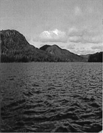
Photo 2: Riparian wetland on Stuart Lake adjacent to the Conservation Reserve.
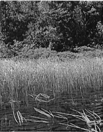
Photo 3: Stream flowing from Stuart Lake to the Conservation Reserve.
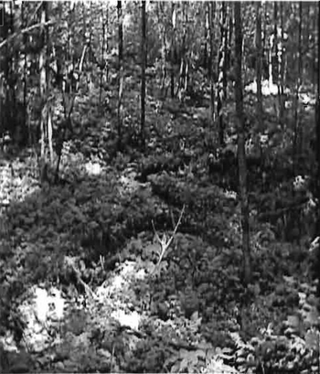
Photo 4: Side of southern hill, looking south to Stuart Creek.
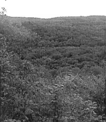
Photo 5: Trail transecting Conservation Reserve, east to west.
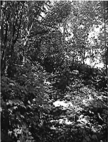
Photo 6: Old building on old logging road next to Stuart Lake.
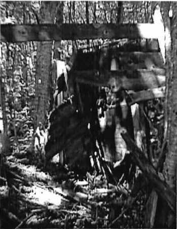
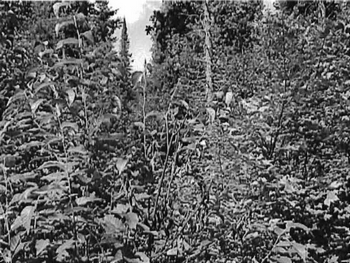
Photo 7: Thicket swamp, south side of central wetland.
Appendices
Appendix A: SCI Test of Compatibility
Test of Compatibility
-
Conformity to SCI/RMP-SCI describes values for which an area has been set aside and the range of appropriate uses that will be permitted in the area. SCI may also speak to the acceptability of other 'new' uses currently not occurring in the area.
The first 'test' is: "do proposed new land uses and/or commercial activities conform to the direction of the SCI/RMP for the conservation reserve? Would the new use(s) depart from the spirit of appropriate indicator land uses in the SCI/RMP?"
-
Screening Process - proposed uses for the area must be assessed before they are approved. To establish a minimum standard, Northeast Region (NER) recommends that the Screening Process identified in Section 4.2 of A Class EA for Provincial Parks and Conservation Reserves Phase IIb: Draft Class EA (subject to approval by MOE) be used to screen projects and options.
-
Impact Assessment - the Test of Compatibility from the Conservation Reserve Policy (PL 3.03.05) identifies the classes of values and main concepts that need to be considered in determining the impacts of uses on a specific Conservation Reserve. These include:
- Natural heritage
- Cultural
- Research activities
- Current uses
- Area administration
- Accommodating the use outside the conservation reserve
- Socio-economics
- Area accessibility.
The class EA (Table 4.1) presents similar values and concepts under the following considerations:
- Natural environment
- Land use, resource management
- Social, cultural and economic
- Aboriginal
The above considerations and classes of values are meant to assist planning staff in answering the following questions for any potential use:
- Will the new use impact any values within the Conservation Reserve?
- If so how?
- To what degree?
- Is it tolerable?
Appendix B: Permitted Uses
Crown land use atlas – Policy report
C262
Stuart Lake Wetland
Updated: September 25, 2002
Identification:
ID: C262
Area name: Stuart Lake Wetland
Area (ha): 661
Designation: Conservation Reserve (Ontario’s Living Legacy)
District(s): Sault Ste. Marie
Description:
This is the best example of sugar maple, balsam fir, white birch, yellow birch and cedar growing on steep hills of glacial till and bedrock In Site District SE-1. Rich wetlands fill the valleys between the hills.
Stuart Lake Wetland was regulated as a conservation reserve on April 6, 2001.
Land use intent:
Management of this area is also governed by the general policies contained in the Land Use Strategy (1999).
Management direction:
Those uses and management activities not listed in the following table are governed by existing conservation reserve policy. Over time the management direction will be elaborated in a Statement of Conservation Interest of Resource Management Plan. Any new uses and commercial activities associated with conservation reserves will be considered on a case by case basis, and they must pass a test of compatibility to be acceptable. Compatibility is normally determined through a planning process.
Commercial activities
| Activity | Permitted | Guidelines |
|---|---|---|
| Aggregate Extraction | No | |
| Bait Fishing Existing: | Yes | Existing use permitted to continue, unless there are significant demonstrated conflicts. |
| Bait Fishing New: | Maybe | New operations can be considered, subject to the "test of compatibility" |
| Commercial Fishing Existing: | Yes | Existing use permitted to continue, unless there are significant demonstrated conflicts. |
| Commercial Fishing New: | Maybe | New operations can be considered, subject to the "test of compatibility". |
| Commercial Fur Harvesting Existing: | Yes | Existing use permitted to continue, unless there are significant demonstrated conflicts. Existing trap cabins can continue; new cabins are not permitted. |
| Commercial Fur Harvesting New: | Maybe | New operations can be considered, subject to the "test of compatibility". |
| Commercial Hydro Development | No | |
| Commercial Timber Harvest | No | |
| Commercial Tourism Existing: | Yes | Existing authorized facilities can continue, unless there are significant demonstrated conflicts. |
| Commercial Tourism New: | Maybe | New tourism facilities can be considered during the planning for an individual reserve. |
| Bear Hunting by Non residents (guided) Existing: | Yes | Existing authorized operations permitted to continue. |
| Bear Hunting by Non residents (guided) New: | No | New operations not permitted. |
| Outfitting Services Existing: | Yes | Existing authorized operations permitted to continue. |
| Outfitting Services New: | Maybe | New operations can be considered during the planning for an individual reserve. |
| Outpost Camps Existing: | Yes | Existing authorized facilities permitted to continue. |
| Outpost Camps New: | Maybe | New facilities can be considered during the planning for an individual reserve. |
| Resorts/lodges Existing: | Yes | Existing authorized facilities permitted to continue. |
| Resorts/lodges New: | Maybe | New facilities can be considered during the planning for an individual reserve. |
| Boat Caches (Managed) | ||
| Energy Transmission and Communications Corridors Existing: | Yes | These facilities should avoid conservation reserve lands wherever possible. |
| Energy Transmission and Communications Corridors New: | No | |
| Food Harvesting (Commercial) Existing: | Maybe | |
| Food Harvesting (Commercial) New: | Maybe | |
| Mineral Exploration and Development | No | |
| Peat Extraction | No | |
| Wild Rice Harvesting Existing: | Yes | |
| Wild Rice Harvesting New: | Maybe |
Land and resource management activities
| Activity | Permitted | Guidelines |
|---|---|---|
| Crown Land Disposition Private Use: | Maybe | Sale of lands is not permitted, except for minor dispositions in support of existing uses (e.g. reconstruction of a septic system). Renewals of existing leases and land use permits are permitted. Requests for transfer of tenure will be considered in the context of the Statement of Conservation Interest or Resource Management Plan. |
| Crown Land Disposition Commercial Use: | Maybe | New leases or land use permits permitted for approved activities. Tourism facilities can apply to upgrade tenure from LUP to lease. |
| Fire Suppression | Yes | Fire suppression policies are similar to adjacent Crown lands, unless alternative fire policies have been developed through a planning process. |
| Fish Habitat Management | Maybe | |
| Fish Stocking | Maybe | Conservation Reserves policy indicates that "featured species management" may be permitted. |
| Inventory/disease Suppression | Maybe | |
| Inventory/Monitoring | Yes | |
| Prescribed Burning: | Maybe | |
| Roads (Resource Access) Existing: | Yes | Existing roads can continue to be used. Continued use will include maintenance and may include future upgrading. |
| Roads (Resource Access) New: | Maybe | New roads for resource extraction will not be permitted, with the exception of necessary access to existing forest reserves for mineral exploration and development. |
| Vegetation Management | Maybe | Conservation Reserves policy indicates that Featured Species Management and Natural Systems Management may be permitted. Vegetation management can be considered in a planning process. |
| Wildlife Population Management | Maybe |
Science, education and heritage appreciation
| Activity | Permitted | Guidelines |
|---|---|---|
| Collecting | No | |
| Historical Appreciation | Yes | |
| Nature Appreciation | Yes | |
| Photography and Painting | Yes | |
| Research | Yes | |
| Wildlife Viewing | Yes |
Recreation activities and facilities
| Activity | Permitted | Guidelines |
|---|---|---|
| All Terrain Vehicle Use On Trails: | Yes | Existing use permitted to continue where it does not adversely affect the values being protected. ATV use off trails is not permitted except for direct retrieval of game. |
| All Terrain Vehicle Use Off Trails: | No | |
| Campgrounds | Maybe | |
| Food Gathering | Yes | |
| Horseback Riding (trail) | Yes | Existing use on trails permitted. |
| Hunting | Yes | |
| Mountain Bike Use | Yes | Existing use on trails permitted. |
| Motor Boat Use Commercial: | Yes | |
| Motor Boat Use Private: | Yes | |
| Non-motorized Recreation Travel | Yes | |
| Private Recreation Camps (Hunt Camps) Existing: | Yes | Existing camps permitted to continue, and may be eligible for enhanced tenure, but not purchase of land. |
| Private Recreation Camps (Hunt Camps) New: | No | |
| Rock Climbing: | Maybe | |
| Snowmobiling On Trails: | Yes | Existing use permitted to continue where it does not adversely affect the values being protected. |
| Snowmobiling Off Trails: | Maybe | Snowmobile use off trails is not permitted, except that snowmobiles may be used for direct retrieval of game. |
| Sport Fishing | Yes | |
| Trail Development Existing: | Maybe | Development of trails for a variety of activities (e.g. hiking, cross-country skiing, cycling, horseback riding, snowmobiling) can be considered as part of planning for an Individual reserve. |
| Trail Development New: |
Note: The policies outlined in this table do not supersede any Aboriginal or treaty rights that may exist, or other legal obligations.
Management of this conservation reserve is carried out within the context of Conservation Reserve policy as amended by the policies for new conservation reserves outlined in the Ontario’s Living Legacy Land Use Strategy.
Source of direction:
Ontario’s Living Legacy Land Use Strategy (1999)
Conservation Reserves Policy (1997)
Sault Ste. Marie District Land Use Guidelines (1983)
Explanation of edits:
Appendix C: Public Consultation Handouts
September 1, 2000
To: Ontario living legacy stakeholders
Dear Sir/Madam:
On July 16, 1999, the Ontario Government released the Ontario’s Living Legacy Land Use Strategy, a broad land use approach to the planning and management of much of the Crown lands in central and parts of northern Ontario. A major part of the Ontario’s Living Legacy Land Use Strategy was a government commitment to the biggest expansion of provincial parks and conservation reserves in Ontario’s history. Ontario intends to add 378 new areas to its protected areas system. Ontario’s Living Legacy is a momentous achievement that will be recognized around the world as a significant contribution to sustaining our natural environment. A copy of the Land Use Strategy is available from our office upon request.
In accordance with the recommendations in the Land Use Strategy, the Ministry of Natural Resources is now implementing the process of establishing these 378 new protected areas. The first step in this process is for the Ministry to consult on the boundaries of these areas. In November 1999, MNR held boundary consultations on 64 sites across the OLL Planning Area. Eight of these sites were within Sault Ste. Marie District. At this time, Sault Ste. Marie District has prepared 19 more sites for boundary refinement consultation. Adjacent Districts are consulting an additional two sites, which are also partially contained within Sault Ste. Marie District, on. In future years, the remaining recommended protected areas from the Land Use Strategy will be put forward for similar consultations.
As stated in the Land Use Strategy, the boundary refinement process will consider local ecological information and will attempt to establish regulated boundaries along features that can be identified on the ground. The boundary refinement process may result in modest increases or decreases in the sizes of the protected areas. Any existing commitments for the areas, which were considered during the land use planning process, will be considered in defining the final boundary.
Following is a list of the 21 sites in SSM District scheduled for boundary consultation this year. These sites include both provincial parks and conservation reserves. The Land Use Strategy established the Ministry’s intent to add these Crown lands to Ontario’s protected areas system, following the extensive public consultation associated with Ontario’s Living Legacy and the Lands for Life land use planning initiatives between 1997 and 1999. The Ministry is inviting public comment on the proposed boundaries of these protected areas prior to their finalization and ultimate regulation under the Provincial Parks Act or the Public Lands Act.
C227 - Glen Crombie Conservation Reserve P238- Mississagi River Provincial Park Additions C243 - Wagong Lake Forest Conservation Reserve C244- Rawhide Lake Conservation Reserve
C246 - Echo River Hardwoods Conservation Reserve
C247- Byrnes Lake White Birch Conservation Reserve
P253 - Goulais River Provincial Park
C256 - Basswood Lake Hemlock Conservation Reserve
C258- Thessalon River Delta I Rock Lake Red Oak Conservation Reserve
C260 - Rose Lake Dune Peatland Complex Conservation Reserve
C262- Stuart Lake Wetland Conservation Reserve
P273- Algoma Headwaters Provincial Park
P274 - Wenebegon River Provincial Park
P277 - Aubinadong - Nushatogaini Rivers Provincial Park
P278- Pancake Bay Provincial Park Additions
P282 - Batchawana River Provincial Park
P285 - Sandy Islands Provincial Nature Reserve
C289 - Searchmont South Forest Conservation Reserve C291 - Goulais River Beach Ridges Conservation Reserve P292 - Lake Superior Provincial Park Additions
C307 - lie Parisienne Conservation Reserve
Your name and address have been included within a Ministry mailing list of persons potentially interested in these boundary consultations. The mailing list includes a range of individuals and groups, such as nearby landowners, resource users, persons with other rights or tenure (e.g. land use permit, Mining Act rights), municipalities, and others who may have an interest in the area. Accompanying this letter, you will find background information (factsheets, maps) for the site(s) we have determined to be of interest to you. More detailed maps and information about the proposed boundaries for all 21 sites are available from this office, or from the Blind River Area Office, 62 Queen Ave., Blind River.
In the future and subject to the intended regulation of these areas as provincial parks and conservation reserves, Ontario Parks and the Ministry of Natural Resources will undertake a management planning process to determine the long-term management of these protected areas. Depending upon the complexity of issues related to the provincial parks, management planning may take the form of a simple Interim Management Statement or a more detailed Park Management Plan. In the case of planning for conservation reserves, a simple SCI or a more detailed Resource Management Plan will result. Please let us know if you would like to be notified when planning begins.
Planning, management and permitted uses within these provincial parks and conservation reserves would be consistent with the commitments of the Ontario’s Living Legacy Land Use Strategy.
The Ministry is collecting comments and information regarding these proposed provincial park and conservation reserve boundary reviews under the authority of the Provincial Parks Act and the Public Lands Act respectively. These comments will assist the Ministry in making decisions and determining further public consultation needs. Comments and opinions will be kept on file and may be included in study documentation that is made available for public review. Under the Freedom of Information and Protection of Privacy Act (1987), personal information will remain confidential unless prior consent is obtained. However, the Ministry may use this information as public input on other resource management surveys or projects. For further information regarding this Act, please contact Paul Glassford, A/Information Management Supervisor, Ministry of Natural Resources, Sault Ste. Marie District (705-949-1231).
If you would like to discuss the proposed boundaries and the protection of these areas under the Provincial Parks Act and/or the Public Lands Act, please contact Erin Nixon, District Planner, Ministry of Natural Resources, 64 Church Street, Sault Ste. Marie, Ontario, P6A 3H3; telephone 705-949-1231 ext. 247, fax (705) 949-6450, by October 6, 2000. Further information on Ontario’s Living Legacy is available in our office or by visiting the Ministry’s internet website at www.mnr.gov.on.ca/MNR/oll/.
Thank you for your interest.
Yours sincerely,
Dick Hagman
A/District Manager
Sault Ste. Marie District
DH/sw
Attachments
Provincial Park and/or Conservation Reserve Factsheet(s)
Proposed Site Boundary Map(s)
Key Map
Permitted Uses Table(s) for Provincial Parks and/or Conservation Reserves
On peut obtenir Ia version fran aise de Ia presente lettre en s'adressant au bureau du MRN le plus proche, a l'adresse ou au numero de telephone ci-dessous.
Stuart Lake Wetland Conservation Reserve (C262) fact sheet
Background
September 2000
On July 16, 1999, the Ontario Government released the Ontario’s Living Legacy Land Use Strategy to guide the planning and management of Crown lands in central and parts of northern Ontario. A major part of the Ontario’s Living Legacy Land Use Strategy was a government intent to establish 378 new protected areas. This commitment marks the biggest expansion of provincial parks and conservation reserves in Ontario’s history.
The proposed Stuart Lake Wetland Conservation Reserve is part of this significant expansion of Ontario’s protected areas system.
Size and location
The Stuart Lake Wetland Conservation Reserve is approximately 661 ha in area, and is located approximately 30 km north of the Town of Bruce Mines. It is located in the Townships of McMahon and Chesley Additional, and is situated on the west shore of Stuart Lake. This conservation reserve protects an area that has been recommended as provincially significant.
Area highlights
The Stuart Lake Wetland Conservation Reserve is located within ecological site district 5E-1, a 25-km deep band of land extending from Sault Ste. Marie to Spanish along the St. Mary’s River and Lake Huron shoreline. This site district is characterized along the coast by lacustrine plains interrupted by small bedrock knolls, and inland by bedrock controlled, till-covered uplands. Natural vegetation communities that develop within this area combine species from both the Great Lakes I St. Lawrence and Boreal forest regions.
The Stuart Lake Wetland Conservation Reserve is located at the northern limit of the site district in an area characterized by very strongly broken uplands. Access to the area is limited due to topographic and wetland constraints.
A high rock ridge runs through the center of the site in a northwest to southeast direction. Forest cover on the ridge is predominantly deciduous, and stands are fairly even-aged (approximately 85 years). This suggests the occurrence of either a fire or clearcutting disturbance in the past. The ridge is flanked by lower lying, cooler ravine areas dominated by mature to old growth stands of sugar maple (approximately 145 years) and yellow birch (approximately 190 years). Hemlock and eastern white cedar are scattered through these ravine stands. A large, linear, lake-filled wetland marsh occupies the ravine trough at the southern base of the ridge, and forms a headwater wetland that drains to Letz Creek, a tributary of the Echo River.
Land use intent
Conservation reserves are areas of Crown land set aside by regulation under the Public Lands Act.
Conservation reserves complement provincial parks in protecting representative natural areas and special landscapes. Most recreational (e.g. hiking, skiing, tourism related uses, nature appreciation) and non-industrial (e.g. fur harvesting, commercial fishing and bait harvesting) activities that have traditionally been enjoyed in the area will continue, provided that these uses do not impact on the natural features needing protection. Hunting and fishing are also permitted within all new conservation reserves recommended through Ontario’s Living Legacy.
Commercial timber harvesting, mining, aggregate extraction and commercial hydroelectric development are prohibited in conservation reserves. Careful mineral exploration may occur in specific new conservation reserves proposed through Ontario’s Living Legacy, in areas that have provincially significant mineral potential. If a portion of a new conservation reserve is to be developed for a mine, it would be removed from the reserve, and appropriate replacement lands would be placed in regulation. Please refer to Table 4 from the Land Use Strategy for a detailed summary of permitted uses in conservation reserves.
Next steps
The Land Use Strategy established the Ministry’s intent to add these Crown lands to Ontario’s protected areas system, following the extensive public consultation associated with the Ontario’s Living Legacy and Lands for Life land use planning initiatives between 1997 and 1999. Prior to the finalization of the boundary of this conservation reserve proposed for regulation under the Public Lands Act, the Ministry is inviting public comment on the proposed boundary from all potentially affected stakeholders and First Nations from September 6 to October 6, 2000.
In the interim, the area has been withdrawn and protected from resource extraction activities such as timber harvesting, hydroelectric development, aggregate extraction and new mineral exploration.
In the future and subject to the intended regulation of the area as a conservation reserve, the Ministry of Natural Resources will prepare a long term management plan for this area. Depending upon the complexity of issues within this conservation reserve, management planning may take the form of a simple SCI or a more detailed Resource Management Plan. Please let us know if you would like to be notified when planning begins.
Planning, management and the uses permitted within this conservation reserve will be consistent with the commitments of the Ontario’s Living Legacy Land Use Strategy.
For more information
For further information on the proposed Stuart Lake Wetland Conservation Reserve, please contact Erin Nixon, District Planner, Ministry of Natural Resources, Sault Ste. Marie District (705-949-1231
ext. 247). You may also visit the Ministry’s internet website at www.ontarioslivinglegacy.com for information about Ontario’s Living Legacy.
August 22, 2001
Regulation of Ontario’s Living Legacy Protected Areas in Sault Ste. Marie District
In July 1999, the Ontario Government released the Ontario’s Living Legacy Land Use Strategy, a broad land use approach to the planning and management of Crown lands in central and parts of northern Ontario. A large component of the Ontario’s Living Legacy Land Use Strategy was a government commitment to add 378 new provincial parks and conservation reserves to Ontario’s protected areas system.
In November 1999 and again in September 2000, we provided you with the opportunity to comment on the proposed boundaries for the park and the conservation reserves in Sault Ste. Marie District. I am pleased to inform you that, as of January 2001, the park and fifteen of these conservation reserves have been regulated. The new park and conservation reserves in the District are:
- P285 Sandy Islands Provincial Nature Reserve
- C243 Wagong Lake Forest Conservation Reserve
- C244 Rawhide Lake Conservation Reserve
- C245 Jollineau Conservation Reserve Conservation Reserve
- C246 Echo River Hardwoods Conservation Reserve
- C258 Thessalon River Delta/Rock Lake Red Oak Conservation Reserve
- C260 Rose Lake Dune Peat/and Complex Conservation Reserve
- C262 Stuart Lake Wetland Conservation Reserve
- C263 Garden Lake Forest Conservation Reserve
- C281Tilley Creek West Conservation Reserve
- C284 Wabos North Conservation Reserve
- C286 Wabos South Conservation Reserve
- C289 Searchmont South Forest Conservation Reserve
- C294 O'Connor Conservation Reserve
- C298 Harmony Forest Conservation Reserve
- C307 lie Parisienne Conservation Reserve
Regulation means the park and conservation reserves are now legally mapped and recognized as protected areas of crown land under the jurisdiction of the provincial government. As such, these areas will be protected from industrial activities, including commercial forestry, hydroelectric development, mining, and aggregate and peat extraction. Traditional recreational and resource uses such as hunting, fishing, hiking, canoeing, boating, and fur trapping, will generally be permitted to continue within the conservation reserves. In nature reserve class provincial parks (e.g. P285, Sandy Islands), hunting and fur trapping are not permitted; other traditional recreational uses (fishing, hiking, canoeing, boating) may continue.
Ontario Parks staff is responsible for the planning and management of Sandy Islands Provincial Nature Reserve and they will prepare an Interim Management Statement to guide the management of this property. Sault Ste. Marie District is responsible for the management of the conservation reserves and will develop Statements of Conservation Interest (SCI) to guide the management of each new conservation reserve. There will be opportunity for the public to review and comment on draft SCIs for each conservation reserve. Depending upon the complexity of issues related to the sites and their management, more detailed Management Plans may, in due course, may be required.
Detailed maps of the regulated boundaries for these new protected areas are available for viewing in the Sault Ste. Marie District office and the Blind River Area office of the Ministry of Natural Resources.
If you have any questions or concerns about the management of Sandy Islands Provincial Nature Reserve, please contact Chris Caldwell, Ontario Parks at the Sault Ste. Marie District Office. Concerns regarding any of the conservation reserves, should be addressed to Sheila Walsh (OLL Resource Planner) also at the Sault Ste. Marie District Office.
Thank you for your interest in Ontario’s Living Legacy. Yours truly,
Tom Mispel-Beyer
A/District Manager
Sault Ste. Marie District
Telephone: 705-949-1231
Facsimile: 705-949-6450
E-mail: tom.mispelbeyer@mnr.gov.on.ca
TMB/gm
Footnotes
- footnote[1] Back to paragraph This Test of Compatibly is taken from both Procedural Guidelines B-Land Uses -Test of Compatibility PL 3.03.05 and from the Planning Process for Conservation Reserve Statement of Conservation Interest and Resource Management Plan Northeast Region Guidelines Version 2.1 September 17, 2001.