Timber Island Provincial Park Management Plan
This document provides policy direction for the protection, development and management of Timber Island Provincial Park and its resources.
Examination and adjustment history
| Approval date | Examination or type of adjustment | Examination outcome (where applicable) | List of supporting documents |
|---|---|---|---|
| March 30, 2012 | Examination | Administrative update | Timber Island Provincial Park Examination Confirmation Statement |
| March 27, 2019 | Administrative update | n/a | Administrative Update Form |
Approval statements
Timber Island Provincial Park Management Plan administrative update
March 27th, 2019
Ontario Parks has updated the Timber Island Park Management Plan (1985) to:
- address dated formatting, terminology, maps, statistics and targets
- and add or update standard direction from provincial policy and legislation that has been revised or repealed since 1985
The need for the administrative update was the outcome of an examination approved March 30, 2012. Information from the examination has been incorporated into the management direction. No new site-specific policy changes have been made as this update is administrative in nature.
Greg Walsh
Manager, Southeast Zone
Regional Director’s approval statement
September 27, 1985
Timber Island was placed into regulation as a nature reserve class provincial park on January 24, 1985. This interim management statement will direct the management of Timber Island Provincial Nature Reserve until a comprehensive management plan is prepared.
Approved and signed by:
J. R. Oatway
Regional Director
Eastern Region
1.0 Introduction
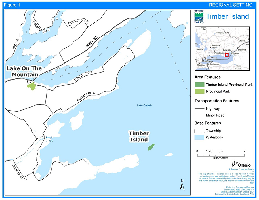
Timber Island Provincial Park is a 44 hectare nature reserve class park located off the shore of Prince Edward County. A private landowner donated the island to the Crown, which was later regulated as a provincial park in 1985.
Timber Island Provincial Park lies within the boundary of the Ministry of Northern Development, Mines, Natural Resources and Forestry (MNDMNRF) Peterborough District and is managed by the park superintendent, reporting to the zone manager at the Ontario Parks Southeast Zone office.
Timber Island is near several protected areas that help protect the south shore peninsula of Prince Edward County. The park is located just off the shore of Prince Edward Point National Wildlife Area, and there are several other wildlife areas, provincial parks, conservation areas, and locally designated nature reserves located nearby. Sandbanks and North Beach Provincial Parks are along the county shore further to the west, and there are nearby islands administered by Parks Canada.
This management plan provides the long-term direction for managing Timber Island Provincial Park.
2.0 Planning context
In 2007, the Provincial Parks and Conservation Reserves Act, 2006 (PPCRA) came into effect replacing the Provincial Parks Act.
The PPCRA established two principles that guide all aspects of planning and management of Ontario’s system of provincial parks and conservation reserves:
- maintenance of ecological integrity shall be the first priority and the restoration of ecological integrity shall be considered
- opportunities for consultation shall be provided
Other legislation (e.g. Endangered Species Act, 2007), policies, initiatives (e.g. climate change, invasive species) and best practices (e.g. adaptive management, landscape level planning) also provide additional direction for protecting Ontario’s biodiversity and contribute to guiding protected area planning and management.
All projects undertaken in Timber Island Provincial Park must comply with Environmental Assessment Act requirements where applicable.
2.1 Ecological integrity
Ecological integrity is a concept that addresses three ecosystem attributes – composition, structure and function. This concept is based on the idea that the composition and structure of the protected area should be characteristic for the natural region and that ecosystem functions should proceed normally. Simply stated, ecosystems have integrity when their lands, waters, native species and natural processes are intact.
All planning and management activities for Timber Island Provincial Park will consider ecological integrity first and foremost in their implementation.
3.0 Indigenous communities
Timber Island Provincial Park is located within the Treaty and traditional territory of the Williams Treaties First Nations, which includes the Mississaugas (Alderville, Hiawatha, Scugog Island and Curve Lake First Nations) and Chippewas (Beausoleil, Georgina Island, and Rama First Nations).
The park is also within the asserted traditional territory of the Mohawks of the Bay of Quinte.
4.0 Location and boundary
The entire island is owned by the province, having been donated by a private landowner in 1962. To have better control over access to the island, a 10 metre (m) extension into the bed of Lake Ontario has been included within the park boundary.
The park falls within the Picton eco-district (6E-15) in the Mixedwood Plains Ecozone.
5.0 Provincial park classification and objectives
Through park classification, Ontario's provincial parks are organized into broad categories, each of which has particular purposes and characteristics. Timber Island Provincial Park is classified as a nature reserve park.
The objectives of nature reserve class parks are to protect representative ecosystems and provincially significant elements of Ontario’s natural heritage, including distinctive natural habitats and landforms, for their intrinsic value, to support scientific research and to maintain biodiversity (OMNR, 1992). As a nature reserve, the principle objective for the park will be resource protection.
6.0 Provincial park values
Inventories of the park include reconnaissance-level earth science (Cordiner, 1977) and life science (Hainault, 1969), and an International Biological Program check-sheet (Hainault et. al, 1969).
Earth science features in the park are considered to be of local significance only.
The soil site types of Timber Island can be characterised as dry to very dry, cooler than normal, limestone rock, and shallow loam/clay-loam. The landscape unit is minor wet mesic to wet depressions. The life-science species/communities of the park include Oak-Hickory forest and parkland, which support provincially and regionally rare plants. The island is on a significant bird migration corridor (Hainault, 1969).
The geological themes of Timber Island include: Middle Ordovician marine platform carbonate environment, featured as Verulam Formation in a 3m cliff around the island; Pleistocene environment, featured as the glacially moulded island; and recent environments, featured as cobble beaches and shore cliffs (Cordiner, 1977). There is no identified cultural resource representation (no theme/theme segments). No assessment of archaeological values has been completed.
There are no day-use, car camping, or wilderness/backcountry recreational opportunities.
7.0 Zoning
The entire island will be managed as a nature reserve zone. The 10 m extension into the bed of Lake Ontario will be managed as an access zone due to shoreline limitations (see Section 8.7).
8.0 Policies
8.1 Industrial
The following industrial and commercial uses are not permitted within Timber Island Provincial Park:
- commercial timber harvest
- generation of electricity
- prospecting, staking mining claims, developing mineral interests or working mines
- other industrial uses
8.2 Wildlife
The park is located on a major bird migration route which crosses the eastern end of Lake Ontario. The extent to which the island is used by migrating birds for resting and feeding is not known. It is, however, undoubtedly valuable to birds forced down by bad weather during migration. Timber Island was a nesting site for the bald eagle prior to 1963. It may be a suitable site for re-establishing the species as a breeding resident of eastern Lake Ontario.
In conformity with provincial park policies, hunting and trapping will not be permitted in the park (OMNR, 1992).
The cooperation of the Kingston Field Naturalists and the Canadian Wildlife Service will be sought in compiling basic wildlife data and in developing a wildlife management plan for the park.
The re-introduction of the bald eagle to the island will be investigated and implemented if feasible.
8.3 Vegetation
Most of the park’s vegetation is at various stages of succession following extensive disturbances (agriculture, grazing and fire) in the early part of the century. On sites with very shallow, dry soils succession has been much slower, resulting in a mosaic of grassland, shrubland and forest vegetation which provides good wildlife habitat.
Timber Island is thought to be part of a postglacial plant migration route across the eastern end of Lake Ontario. Despite its disturbance history, the island has a relatively high diversity of plant species, including some which are regionally to provincially rare. An area of mature oak/hickory forest and parkland represents a forest community not found in other provincial parks in eastern Ontario.
The park’s vegetation will normally be allowed to succeed naturally, without intervention by man. Only if other significant park values (such as provincially rare species) are threatened will active vegetation management be considered.
A decision on whether a vegetation management plan is required will be based on vegetation inventory and mapping (See Section 8.6).
8.4 Fire management
Forest fire management in the park will be in accordance with provincial policies and procedures, including the Wildland Fire Management Strategy for Ontario. The park is located outside of the fire region of Ontario, as defined by the Forest Fires Prevention Act. Outside the fire region, municipalities have a mandate to provide forest fire protection.
While fire has played a major role in the history of the development of the island’s vegetation and should be considered as a management tool for maintaining diversity, there are a number of attendant problems. The size of the island and its tendency to experience severe droughts leave it vulnerable to fires which could devastate the entire island. Access for the purpose of fire control is also difficult as ministry patrol boats are normally docked in the Bay of Quinte, some 50 km away.
Fires of any kind will not be allowed in the park. All fires occurring naturally or otherwise will normally be extinguished as quickly as practicable. If the inventory and analysis of the park’s vegetation suggests that fire should be considered as a management tool, then this will be addressed in a vegetation management plan.
8.5 Land
No land acquisition or boundary changes are required.
8.6 Science, education and heritage appreciation
Research activities require authorization issued under the PPCRA, consistent with relevant policies. Research must meet all requirements under applicable federal and provincial legislation, and may require additional permits or approval (e.g., MNDMNRF Wildlife Scientific Collector authorization or Endangered Species Act, 2007 permits). As a nature reserve, the principle objective for the park will be resource protection.
An inventory and mapping of the park’s vegetation will be undertaken. Research, such as geological research and wildlife research, may be authorized providing it enhances knowledge of the park’s resources and does not impact upon park values. However, in keeping with the philosophy of nature reserve class provincial parks, and with the wishes of the land donor, limited use by scientific researchers and naturalists will be permitted.
8.7 Infrastructure and operations
Access to the park is across approximately 2 km of open water. The exposed shoreline of the island makes it difficult to designate any one landing point. Boats normally land in the lee of the island. Development of a docking facility would be prohibitively expensive and would encourage unauthorized use of the island.
Helicopter landings on the island for illegal purposes (hunting) have been reported in the past.
The following policies apply to the park:
- access facilities will not be developed
- boat access may be restricted to certain sections of the shoreline
- no onshore facilities will be developed
- aircraft landings will not be permitted on the island except in emergency situations
- except for emergencies, all access to the park will be authorized by the park superintendent
- authorization to visit the park may be given to individuals (for research or nature study) or to groups such as field-naturalist organizations
- all visitors must abide by guidelines for party size and permissible activities
- overnight camping will not be permitted unless required to complete a specific research project (See Section 8.6 for research authorizations)
9.0 Implementation
Park and resource management will be contingent upon the availability of funding and resources and unforeseeable changes in priorities or policy and will be undertaken in accordance with the requirements of the Class EA-PPCR and the PPCRA and all other pertinent legislation and policies.
10.0 Examination and adjustment of management direction
This management plan will be examined in accordance with the provisions of the PPCRA to determine whether the management direction is still relevant, effective and current, or if an adjustment is required. In circumstances where this plan is not providing sufficient direction, it can be examined prior to the next scheduled examination.
11.0 References
Cordiner, G. S., 1977. Earth Science Inventory Checklist - Timber Island Wilderness Area. Ontario Ministry of Natural Resources, Toronto.
Hainault, R., 1969. The Flora of the Islands of Eastern Lake Ontario. M. Sc. Thesis (unpublished), Queen’s University, Kingston, Ontario.
Hainault, R. and R. E. Beschel, 1969. International Biological Programme Checksheet - Timber Island. (Available from the Ontario Ministry of Natural Resources in Napanee, Kemptville or Toronto).
Ontario Ministry of Natural Resources, various dates. Unpublished file material at the Eastern Regional Office, Kemptville, Ontario.
Ontario Ministry of Natural Resources. 1992 update. Ontario Provincial Parks: Planning and Management Policies. Ontario Parks. 90 pp. + appendices.
Ontario Ministry of Natural Resources. 2005. A Class Environmental Assessment for Provincial Parks and Conservation Reserves. Toronto, ON. 47 pp. + appendices.
Ontario Ministry of Natural Resources. 2014. Ontario Protected Areas Planning Manual: 2014 Edition. Peterborough. 33 pp.
Ontario Ministry of Natural Resources and Forestry. 2014. Wildland Fire Management Strategy. Toronto.