Twilight Lake Conservation Reserve Management Statement
This document provides policy direction for the protection, development and management of the Twilight Lake Conservation Reserve and its resources.
(C2430)
Statement of Conservation Interest
OMNR, Kenora District
July, 2001
Updated April 7, 2011
Next Examination Due December 31, 2020
Approval statement
We are pleased to approve this Statement of Conservation Interest for Twilight Lake Conservation Reserve.
This Statement of Conservation Interest provides guidance for the management of the conservation reserve and the basis for the ongoing monitoring, activities. More detailed direction at this time is not anticipated. Should significant facility development be considered or complex issues are requiring additional studies, more defined management direction, or special protection measures, a more detailed Conservation Reserve Management Plan will be prepared with full public consultation.
The public was widely consul ted during the original regulation process and further public consultation is not required at this time.
The conservation reserve will be managed under the jurisdiction of the Kenora East Area Supervisor, Kenora District. Ministry of Natural Resources.
Signed by:
Fred S. Hall
District Manager
Kenora District
Date: September 06, 2001
Signed by:
Charlie Lauer
Regional Director
Northwest Region
Date: September 20, 2001
1.0 Background information
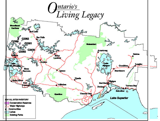
During the Lands For Life process, areas representative of Ontario’s diverse ecosystems and biological/geological features were identified and recommended for regulation as parks and protected areas under the Provincial Parks Act and the Public Lands Act (OMNR, 1999). The goal is to expand the percentage of Ontario’s protected areas to encompass twelve percent of the province’s land and water base. Twilight Lake Conservation Reserve is one of the representative areas selected for protection in site region/district 4S-3 and was regulated on May 21, 2003. The area was selected as a candidate under Ontario’s Living Legacy due to the representative landform and vegetation types (primarily mixed forests on weakly broken end moraine, ground moraine and bedrock) existing within the area.
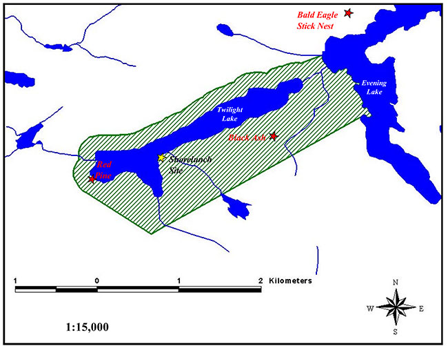
Twilight Lake Conservation Reserve is located northeast of Clay Lake and southeast of Cliff Lake, approximately 85 kilometres northeast of the City of Kenora (OMNR, 2000). (Refer to Appendix A.) The reserve primarily incorporates: Twilight Lake; a 200 metre buffer along the north and west shores of the lake; an area extending from 200 metres southeast of the creek intersecting the south end of Twilight Lake, to Evening Lake in the northeast; and a portion of Evening Lake’s west shoreline, which borders the reserve in the northeast (Appendix B). Aboriginal interests in the area are primarily those of Grassy Narrows and Wabauskang First Nations.
The intent of this Statement of Conservation Interest is to identify the natural heritage values of Twilight Lake Conservation Reserve, the activities occurring within the area and (through a set of management guidelines) outline the activities which will be permitted and prohibited.
For further information regarding the basis of this Statement, please refer to the "Conservation Reserve Policy and Procedure PL3.03.05", specifically, pages 2-6 and 14-22 of the procedure (OMNR, 1997a).
Overview data describing Twilight Lake Conservation Reserve and location
- Name: Twilight Lake Conservation Reserve
- Site Region/Site District: 4S-3
- OMNR Administrative Region/ District/Area: Northwest / Kenora / English River
- Total Area (ha): 396 ha
- Regulation Date: 2001-2002
- First Nations with Interest in Area: Grassy Narrows and Wabauskang First Nations (Treaty #3)
- OBM: 2015470055400
- Latitude/Longitude: 50 06' / 93 25'
- Basemap: 501932
- FRI Stand Numbers (Partially or Wholly Represented Within the Reserve): 100, 189, 395, 400, 584, 592, 896, 977, 1087, 1398, 1600, 1602, 1780, 1797, 1999, 2290, 2293, 2300, 2399, 2692, 2891, 3000, 3197, 3290, 9786, and 9790.
- General Location Description: Located approximately 85 kilometres northeast of the City of Kenora, west of Highway 105 (Appendix A).
- Access: The reserve is accessible by float plane or by boat through Mystery and Evening Lakes off of Deer Lake Road.
1.1 Representation targets
This section provides a summary of the earth/life science values, cultural resources represented, and recreational opportunities available or possible within Twilight Lake Conservation Reserve.
| Life Science Representation |
Ten critical landform-vegetation types are represented within Twilight Lake Conservation Reserve. |
|---|---|
| Earth Science Representation | Site represented by the Wabigoon Subprovince with lacustrine deposits and exposed granitic bedrock (North-South Environmental Inc., 2000a; b). (Refer to section 2.1.2 and Appendix D.) |
| Cultural Resource Representation | No specific values have been identified other than potential significance associated with the overgrown, historical portage route on the west and east shores of Twilight Lake (section 2.1.3). |
| Recreational Opportunities | Fishing (for Muskellunge and Walleye) and hunting opportunities (for Black Bear, Moose, and migratory waterfowl) exist within the reserve. Trapping activities for Beaver (in particular) take place. Additional activities occurring within the reserve include Crown land camping, canoeing, hiking, swimming, and scenic/wildlife viewing. Potential for winter activities exists within the reserve, particularly ice fishing, snowmobiling, and snowshoeing. (Refer to section 2.2.2.) |
1.2 Survey information
This section provides an overview of the inventories completed, their level of detail and any further inventories that are necessary.
| Survey Level | Reconnaissance | Detailed |
|---|---|---|
| Life Science | Checklist and summary report, 2000. Survey conducted via boat access. | Not required. |
| Earth Science | Checklist and summary report, 2000. Survey conducted via boat access. | Not required. |
| Cultural | Suggested. | Not required. |
| Recreational | Recreational assessment, 2001. | Not required. |
| Other | Not required. | Not required. |
2.0 Values to be protected
This section provides a description of the key natural heritage values on the site, their condition relative to past resource use and management activities, as well as their sensitivity to future land use and management activities.
2.1 Values identified on the site
2.1.1 Life sciences
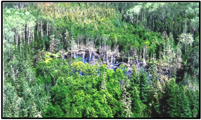
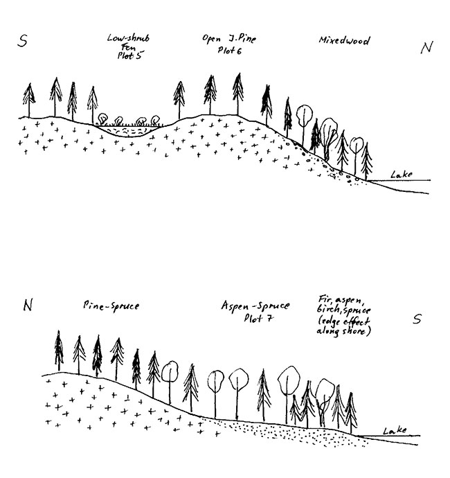
Twilight Lake Conservation Reserve has been identified as an area containing representative vegetation types, comprising mixed coniferous/deciduous forest stands (OMNR, 1999). Earth Science Inventories conducted in the area have confirmed the existence of mixed stands of White Birch, Aspen and Spruce (North-South Environmental Inc., 2000a; c). (Refer to Appendix C.) In addition, Aspen hardwood stands and Jack Pine/Spruce coniferous stands have been identified within the reserve boundaries. One small stand of Black Ash aged at 125 years exists in the southeast portion of the reserve. (Refer to Appendix B and Figure 1.) In general, deciduous (Aspen) and mixed (Aspen/Spruce/Fir) stands predominate the forested area closest to Twilight Lake, whereas coniferous Pine-Spruce stands prevail in the distance.
Figure 1. A small stand of 125 year old Black Ash is located in the southeast portion of Twilight Lake Conservation Reserve.
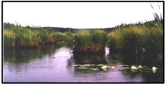
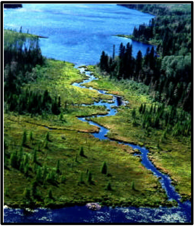
Of particular significance is the Red Pine occurring along the western shore of Twilight Lake (North-South Environmental Inc., 2000a; c). (Refer to Appendix C.) Red Pine represents approximately 10% of this forest stand, whereas Poplar and Jack Pine comprise the remaining 90% (Appendix B). The forest here is estimated to be 90 years of age. In FRI stand # 9786, a cluster of Red Pine (in excess of 50 trees) can be located at approximately 5548620 N and 469999 E (NAD 27). The majority of the wetland ecosystems represented within the reserve occur along the creek adjoining Evening and Twilight Lakes (Figure 2), as well as in palustrine situations (i.e. wetlands with little or no inflow and either permanent or intermittent outflow) above the lakes' water levels (North-South Environmental Inc., 2000a). Low shrub fens with Swamp Birch (Betula pumila), Leatherleaf (Chamaedaphne calyculata), Sweet Gale (Myrica gale) and River Alder (Alnus rugosa) compose the primary wetland vegetative communities. Lesser wetland community types include representation of Sedge/March Reed Grass (Calamagrostis canadensis–Carex) wet meadows, as well as River Alder/Sweet Gale/Sedge thicket swamps.
Figure 2. Wetland communities are represented along the creek adjoining Evening and Twilight Lakes.
2.1.2 Earth sciences
Twilight Lake Conservation Reserve was selected as a candidate for protection under Ontario’s Living Legacy partially due to its earth science representation of exposed bedrock (OMNR, 1999). The conservation reserve’s bedrock geology is represented by the Wabigoon Subprovince, one of the largest geological subprovinces of the Superior Province (North-South Environmental Inc., 2000a;b). This granite-greenstone complex extends 900 kilometres from the Manitoba border near Lake of the Woods, stemming eastward north of Lake Nipigon.
Twilight Lake and its surrounding area were also chosen due to the representation of weakly broken end moraine and ground moraine of lacustrine clay plain and lacustrine sand plain deposits within the area (North-South Environmental Inc., 2000a; OMNR, 1999). (Refer to Appendix D.) Twilight Lake is situated between the Hartmann and Lac Seul moraines which were constructed either through: 1) the retreating and advancement of the ice front associated with the formation of the Eagle-Finlayson moraine 11,000 years ago (Zoltai, 1961); or 2) the deposition of sand and gravel during a catastrophic discharge of meltwater along the ice margin’s edge (Barnett, 1992). The lacustrine action represented within the reserve (and associated landforms) are a result of recent active geomorphological processes (North-South Environmental Inc., 2000a).
2.1.3 Cultural/historical significance
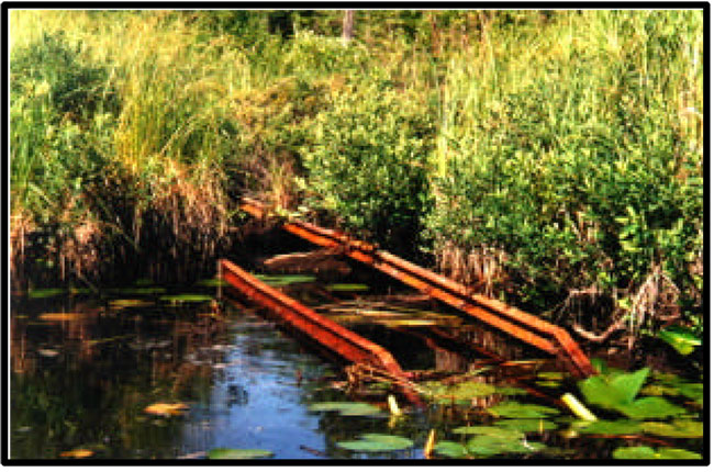
Following the 1897 Gold Rush, Twilight Lake became part of the secondary waterway leading from Quibel to Red Lake (Wall, 2001). A historical portage leading to Clay Lake was established on the west shore of Twilight Lake and, although overgrown, is still easily navigable today (Appendix E). Remnant portions of a portage trail can also be found alongside the creek adjoining Twilight and Evening Lake (Figure 3).
Figure 3. a) The junction of the railway cart system (portage) with the west shoreline of Twilight Lake in the early 1930's. (Source: Leutschaft, 2001).
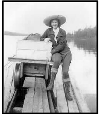
Figure 3. b) Remnants of the railway cart system east of Twilight Lake.
2.1.4 Aboriginal values
Any specific aboriginal values or interests within Twilight Lake Conservation Reserve remain unidentified at this time. (Please refer to section 3.5.)
2.1.5 Tourism
Twilight Lake is a popular fishing area among many tourists residing at nearby camps. There are no tourist lodges or outposts developed within the immediate vicinity of the conservation reserve. However, five camps are situated on Cliff Lake from which Twilight Lake can be reached (in times of high water levels) by traveling via boat through Mystery and Evening Lakes (Appendix E).
2.1.6 Recreational fishing
Twilight Lake holds significant fishing opportunities for Walleye (particularly in the spring and early summer) and Muskellunge (throughout the fishing season). However, the inaccessibility of Twilight Lake highly restricts the degree of fishing activity occurring here. Under low water level conditions, the creek adjoining Evening and Twilight Lakes becomes too shallow to navigate by boat (Figure 3). Furthermore, the extensive Beaver activity in the area contributes to site inaccessibility through damming of the creek. For these reasons, fishing in Twilight Lake typically occurs only during the spring and the first couple of weeks of summer when water levels are sufficiently high.
2.1.7 Recreational hunting
Twilight Lake Conservation Reserve forms part of a Bear Management Area licensed to a nearby camp operator, indicating the potential for hunting of Black Bear in the area. In addition, hunting opportunities exist for Moose and White-tailed Deer, as well as several waterfowl species that are attracted to the wetland ecosystems represented within the reserve.
2.1.8 Mining
Careful mineral exploration may occur in specific new conservation reserves proposed through Ontario’s Living Legacy-Land Use Strategy, in areas that have provincially significant mineral potential. If a portion of the new conservation reserve is to be developed for a mine, it would be removed from the conservation reserve, and appropriate replacement lands would be placed in regulation.
Figure 4. Twilight Lake becomes inaccessible when the creek system draining into Evening Lake dries up under low water level conditions.
2.1.9 Aggregate
None developed on site.
2.1.10 Forest harvest
Timber of commercial value, easy access, and significant volume surrounds Twilight Lake (Anderson, 2001). Four harvest blocks (99.103, 99.106, 99.116 and 99.183) within the conservation reserve boundaries were approved in the 1999 – 2004 term of the Whiskey Jack Forest Management Plan. The MNR removed blocks within the reserve boundaries from the Forest Management Plan through an amendment process.
2.1.11 Trapping
Twilight Lake Conservation Reserve forms part of a registered trapline licensed to a Wabauskang First Nation trapper.
2.1.12 Wildlife
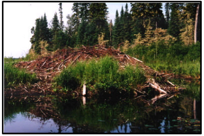
Twilight Lake Conservation Reserve (C2430) – Statement of Conservation Interest 11 Twilight Lake Conservation Reserve is abundant with wildlife, including Moose, Black Bear, White-tailed Deer, Timber Wolves, Red Foxes, and waterfowl species (along the creek systems). Beavers are highly populated in Twilight Lake, as evidenced by the numerous active Beaver lodges distributed throughout the lake and adjacent creek system into Evening Lake (Figure 5). In addition, a Bald Eagle nesting site exists immediately northeast of the conservation reserve (Appendix B).
Figure 5. An abundance of Beavers inhabit the Twilight Lake Conservation Reserve, as evidenced by the numerous active Beaver lodges.
2.1.13 Commercial fish
Twilight Lake Conservation Reserve represents a portion of a commercial baitfishing block.
2.2 Values to be protected
The intent of this Statement is to protect identified values by establishing management guidelines for existing and potential uses in this area given the level of past disturbance, as well as the nature of the existing features.
2.2.1 Forest values
The forest stands within the conservation reserve boundaries are to be protected from any alteration resulting from forest management activities (OMNR, 1999; 1997a). Successional changes associated with each forest type occurring in the area (depending on each stand’s stage of maturity, specific vegetative species composition, and soil type) are anticipated to take place as outlined in the following statements. (Please note that for the purpose of this document, the successional time frame is depicted as 100 years.):
- The conifer-dominated mixedwoods on very shallow, dry to moderately fresh soils within the reserve are 95 years in age. In the absence of natural disturbance, succession of these stands will likely result in stands with declined canopy tree cover, dominated by Black Spruce with remnant Jack Pine and (potentially) White Birch (Anderson, 2001; Dawe, 2001; OMNR, 1997b).
- The hardwood-dominated mixedwoods on fairly moist, coarse to fine loamy/silty soils within the reserve range from 40 to 95 years in age. Over time and in the absence of natural disturbance, pathological problems will likely kill off the hardwood component of these stands allowing coniferous species (particularly Spruce and Balsam Fir) to regenerate the sub-canopy and seedling layers (Anderson, 2001; Dawe, 2001; OMNR, 1997b). The result is anticipated to be a mixed species stand at various stages of maturity and a more open canopy. The anomaly of the Red Pine component of the forested stand along the conservation reserve’s west boundary (aged at 90 years) is such that it will likely maintain itself for the next 100 years.
- Due to the ecology of Black Ash, this stand (at 125 years of age) will likely maintain itself over the next 100 years with possible ingress of Balsam Fir, Aspen, Black Spruce and/or Larch along the leading edges of the stand (Anderson, 2001; Dawe, 2001).
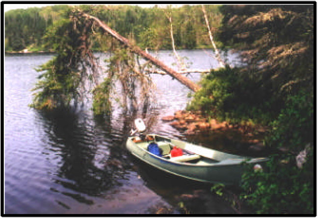
2.2.2 Recreational values
Sport fishing, hunting, and trapping opportunities exist within the Twilight Lake Conservation Reserve (Figure 6). Additional activities occurring within the reserve include Crown land camping, canoeing, hiking, swimming, and scenic/wildlife viewing. One shore lunch site ideal for camping has been established along the southwest shore of the lake (Appendix B). The conservation reserve holds potential for such winter activities as ice fishing, snowmobiling, and snowshoeing.
Figure 6. Sport fishing is a commonly-practiced activity within the Twilight Lake Conservation Reserve.
2.2.3 Tourism values
Twilight Lake is a popular Muskellunge and Walleye fishing area for local tourists during times of high water levels (particularly in the spring). However, as water levels decline, the shallow creek systems, in conjunction with the extensive beaver activity occurring in the area, make the site difficult to access by boat, essentially "cutting off" the area’s accessibility.
3.0 Management guidelines
The following topics briefly indicate the existing situation followed by the management guidelines to be implemented or continued.
3.1 Land tenure
The Twilight Lake Conservation Reserve consists entirely of Crown land. No land disposition by sale, Crown Lease or Land Use Permit for private or commercial use will be permitted within the conservation reserve (OMNR, 1997a).
3.2 Existing and proposed development
An overgrown historical portage route is located on the west shore of Twilight Lake and one camp/shorelunch site has been established along the southwest shore of the lake (Appendix B; E). Other than these, no development has taken place within the Twilight Lake Conservation Reserve. No further development (such as newly established campsites and trails) will be permitted in the area that would result in disturbance of the forest including its understory. Access will be permitted by foot and by boat.
3.3 Recreational activities
Most recreational activities that have been practiced within Twilight Lake Conservation Reserve thus far may continue provided that they pose little threat on the natural ecosystems and features identified/protected within the conservation reserve (OMNR, 1997a). Permissible recreational activities include fishing, hunting, resident Crown land camping, boating/canoeing, hiking, snowshoeing, swimming, and scenic/wildlife viewing. Twilight Lake Conservation Reserve falls within a Green Zone, therefore, non-resident Crown land camping is prohibited within the conservation reserve. Snowmobiling (by waterway) will be permitted to continue provided that the activity does not adversely affect the values to be protected. The construction of new trails will not be permitted.
3.4 Commercial activities
Trapping will continue as a permitted activity, as the area forms part of a Wabauskang First Nation trapline (OMNR, 1999). No trapper’s cabins have been developed within the conservation reserve. The area is presently part of both a baitfishing block and a Bear Management Area; no changes of these areas are required at this time provided that they do not impact the conservation reserve’s identified and protected natural heritage values. No further commercial activities will be permitted in the area, including road construction, removal of aggregates, and development of utility corridors (OMNR, 1999; 1997a).
The conservation reserve has been permanently removed from the operable Whiskey Jack Forest Land Base and withdrawn from all mining exploration and extraction activities by the Ministry of Northern Development, Mines and Forestry (MNDMF) at MNR’s request.
3.5 Aboriginal interests
Twilight Lake Conservation Reserve is likely of primary interest to both Grassy Narrows and Wabauskang First Nations, based on the location of the conservation reserve within relatively close and equal proximity to both First Nations. In addition, the conservation reserve forms part of a trapline issued to an individual from Wabauskang First Nation. Any specific aboriginal values associated with the conservation reserve are unknown at this time, although they may be identified during First Nation consultation. However, nothing in this Statement of Conservation Interest will affect existing or future aboriginal or treaty rights.
3.6 Natural Resources Stewardship
3.6.1 Vegetation management
The Forest Fire Management Strategy for Ontario (OMNR 2004) places Twilight Lake Conservation Reserve in the boreal zone providing the same level of protection from fire as the surrounding forest. Should natural large-scale disturbance (forest fires, blow downs) not take place, the vegetation will mature through successional processes as outlined in section 2.2.1.
Fuelwood permits will not be issued within the area encompassed by the Twilight Lake Conservation Reserve. However, usage of the areas wood resource for shorelunches and campfires will be permitted provided that there will be no resulting damage or alteration of the forest and its understory.
3.6.2 Fisheries and wildlife management
No management action is required other than the implementation of existing Wildlife Management Unit and sport fishing regulations and management activities. Fishing opportunities are limited due to site inaccessibility associated with low water levels.
3.6.3 Landforms
The landforms represented within Twilight Lake Conservation Reserve will not be altered through any landform modification activities, including filling and extraction of aggregates, peat, soils, and similar materials (OMNR, 1997a).
3.7 Cultural Resources Stewardship
No archeological sites or artifacts have been identified or recovered within the Twilight Lake Conservation Reserve, as yet. Any specific archeological significance is unknown, although the potential exists due to the site’s historical usage as a common waterway route. Further research may be beneficial in uncovering any cultural/historical significance within the conservation reserve and ensuring their protection, provided that the research does not alter the currently identified values within the conservation reserve.
3.8 Client services
Information regarding this conservation reserve will be made available so as to ensure that all resource users (particularly forestry and mining companies) are aware of its location, recognized values, and permitted uses. Potential users include tourists, local fishermen/hunters, recreationalists (ex. canoeists, hikers, snowmobilers), and the general public, all of who may utilize the areas wood resource for camping, shorelunches, firewood, and personal use.
3.9 Research
Non-destructive research relating to cultural and historical values within the conservation reserve would be beneficial to add further potential values to the reserve, as well as to ensure their protection.
3.10 Marketing
There are no marketing requirements at this time.
4.0 Implementation
These management guidelines will be implemented immediately by Kenora District. Any MNR Resource Management Plans or Land Use Plans which include this area will be amended accordingly. Any affected clients will be immediately informed of amendments to this management direction. Administrative responsibility for the conservation reserve rests with the Planning and Information Management Supervisor. Implementation will primarily involve monitoring activities to ensure adherence to the management guidelines.
5.0 Review and revisions
5.1 Review and revisions
Methods of reviewing management direction will be consistent with the Protected Areas Planning Manual (OMNR 2009) and its associated guidelines. In accordance with the Provincial Parks and Conservation Reserves Act, 2006, MNR will annually examine management direction documents that have been in place for ten years or more. The next scheduled examination for Twilight Lake Conservation Reserve will be in 2020.
5.2 Public consultation
5.2.1 Results of past consultation
Contact regarding the regulation of Twilight Lake Conservation Reserve was made with timber companies, local communities, and the general public in August, 2000. Consultation efforts involved the direct mailing of a District information package to local interest groups (such as the Local Citizens Committee), as well as to all those with patent land, boat caches, bear management areas, trapline areas, baitfishing areas, and Sustainable Forest Licenses within and/or adjacent to the reserve’s proposed boundaries. In addition, an interview was held on CJRL radio (Kenora) and newspaper advertisements were issued in the Kenora Enterprise and the Kenora Daily Miner in mid-August, 2000. Only a few responses were received regarding C2430, and were specifically related to activities permitted and prohibited within the conservation reserve.
First Nation consultation associated with Twilight Lake Conservation Reserve occurred.
5.2.2 Present and future consultation
Twilight Lake Conservation Reserve (C2430) – Statement of Conservation Interest 17 Other than the completion of First Nations consultation, more widespread consultation is not deemed necessary at this time due to the extensive consultation which took place in August, 2000 (refer to section 5.2.1).
5.2.3 Author
This Statement of Conservation Interest was prepared by Sheila Thomson, OLL Coordinator, Kenora District.
6.0 References
Anderson, Dave. 2001. Area Forester. Personal Correspondence. OMNR, Kenora District.
Barnett, P.J. 1992. Quaternary Geology of Ontario. Geology of Ontario, Ontario Geological Survey. 4(2):1011-1088.
Dawe, Mike. 2001. Senior Forest Specialist. Personal Correspondence. OMNR, Kenora District.
Leutschaft, Oscar. 2001. Local resident near Twilight Lake Conservation Reserve.
North-South Environmental Inc. 2000a. Earth and Life Science Reconnaissance Survey. 14 Provincial Parks and Conservation Reserves in the Western Part of Northwestern Ontario: Summary Report to the Earth and Life Science Checksheets.
North-South Environmental Inc. 2000b. Earth Science Inventory Checklist: Twilight Lake Conservation Reserve.
North-South Environmental Inc. 2000c. Natural Heritage Area - Life Science Checksheet – Twilight Lake Conservation Reserve.
Ontario Ministry of Natural Resources. 1997a. Conservation Reserves Policy and Procedure. PL 3.03.05.
Ontario Ministry of Natural Resources. 1997b. Silvicultural Guide to Managing for Black Spruce, Jack Pine and Aspen on Boreal Forest Ecosites in Ontario. Book II: Ecological and Management Interpretations for Northwest Ecosites. Version 1.1 September, 1997.
Ontario Ministry of Natural Resources. 1999. Ontario’s Living Legacy – Land Use Strategy. OMNR.
Ontario Ministry of Natural Resources. 2000. Twilight Lake Conservation Reserve (C2430) Fact Sheet. OMNR, Kenora District.
Ontario Ministry of Natural Resources. 2004. Forest Fire Management Strategy for Ontario. Queen’s Printer for Ontario, Toronto. 64 pp.
Ontario Ministry of Natural Resources. 2009. Ontario Protected Areas Planning Manual. Peterborough. Queen’s Printer for Ontario. 50 pp.
Provincial Parks and Conservation Reserves Act. 2006. Toronto. 44 pp. [online]
Wall, Sydney. 2001. Local resident near Twilight Lake Conservation Reserve. Personal Correspondence. January, 2001.
Zoltai, S.C. 1961. Glacial history of part of northwesternOntario. Proc. Geol. Assoc. Canada. 13:61-83.
Appendix A
Regional setting of Twilight Lake Conservation Reserve (C2430)
Appendix B
Twilight Lake Conservation Reserve boundaries and associated natural heritage values
Appendix C
Twilight Lake Conservation Reserve Life Science Checksheet (North- South Environmental Inc., 2000c)
Natural Heritage Area – Life Science Checksheet
| Name | Twilight Lake Conservation Reserve C2430 |
|---|---|
| Map Name | Cliff Lake |
| Map Number | 52 K/03 |
| UTM Reference | 471625 5549500 |
| County | Unorganized Area |
| Latitude | 50 06' |
| Longitude | 93 24' |
| NAD | 83 |
| Minimum Altitude | 400 |
| Maximum Altitude | 450 |
| Locality | Unorganized Area |
| Township | Unorganized Area |
| Area | 396 ha |
| Ownership | Crown Land |
| MNR Region | Northwest |
| Ecoregion and Ecodistrict | 4S3 |
| Landform Unit(s) | See attached table |
| MNR District | Kenora |
| Aerial Photographs Year – Roll – Flight Line – Numbers |
Map - Life Science Checklist
Physical and Biological Features
| Representation | The major forest types in the reserve include aspen hardwoods, mixed stands of white birch, aspen-spruce mixedwoods and Jack pine-spruce coniferous stands on shallow soils on bedrock. The principal wetland types include low shrub fens with Betula pumila, Chamaedaphne calyculata, Myrica gale and Alnus rugosa. The wetlands mostly occur along the creek between Twilight and Evening Lakes, or in palustrine situations above the water level of these two lakes, but hydrologically connected with them via small watercourses. Lesser community types are represented by Calamagrostis canadensis-Carex wet meadows, Alnus rugosa and Myrica Gale-Carex thicket swamps along the lake shoreline, as well as a small stand of black ash at a creek’s mouth on the south shore of the lake. Deciduous (aspen) and mixed (aspen-spruce-fir) stands are generally located closer to the lake, while farther away pine-spruce mixedwoods tend to dominate. The lake is an important fishing site for muskellunge and walleye. Signs of presence of typical wildlife (beaver, moose, squirrel) were observed. |
|---|---|
| Condition | Because of their remoteness and access only by boat all vegetation communities are in natural condition. At present, the only source of human disturbance seems to be fishing, with which may be associated local littering and overnight camping. However, during the survey no littering problem was detected in the upland areas. Thrown-away pop cans were abundant, however, on the bottom of the creek between Cliff and Mystery Lakes nearby, and one might expect the same problem in similar situations in the reserve. |
| Diversity | The reserve exhibits the level of diversity typical of similarly sized lakes in the area. The predominant cover types are forests and wetlands. Despite mostly consisting of a 200-metre buffer around the lake, there is a considerable number of forest types being represented. The wetlands consist of graminoid, low shrub and tall shrub types. |
| Ecological Considerations | The compact, rectangular size of the reserve helps maintain the integrity of its ecosystems, despite its small size. The reserve, particularly the creek, functions as an ecological corridor between the system associated with Twilight Lake and Evening and Mystery Lakes downstream. There is a fair range of upland and wetland habitats that support a diversity of plant species. Because of the buffered nature of the reserve, a "staggered" logging regime along its boundary over a number of years should ensure a continuous supply of variously aged forest ecosystems. |
| Special Features | A small stand of red pine occurs along the west shore of Twilight Lake. A cluster of red pine can also be found along the historical portage route, 50 to 100 m from the west shore of the lake. |
| Major Information Sources | September 2000 field work, MNR's August 2000 fact sheet |
| Significance Level (Provincial/Regional/Local) and Brief Summary of Major Representative Values | Regional significance because of the presence of red pine and representative diversity of vegetation types. |
| Date Compiled | November 2000 |
| Compiler | Christopher Zoladeski, North- South Environmental Inc. |
Twilight Lake Conservation Reserve
Plot sampling methods follow those outlined in:
North-South Environmental Inc. 2000. Earth and Life Science Reconnaissance Survey. 14 Provincial Parks and Conservation Reserves in the Western Part of Northwestern Ontario: Summary Report to the Earth and Life Science Checksheets. 20pp.
Plot 1: 473037E 5550231N
Ca. 300 m SE from mouth of creek from Twilight Lake, on Evening Lake shore.
Description: Medium-aged white birch-dominated mixedwood, with an admixture of fir as discontinuous lower canopy. Discontinuous shrub and herb layers. Significant deadwood throughout – snags and logs of both birch and fir. Also, some old decomposed stumps.
Composition:
T:
- Betula papyrifera 4
- Abies balsamea 1
TS:
- Abies balsamea 2
LS:
- Acer spicatum 2
- Rosa acicularis 1
- Diervilla Lonicera +
- Rubus pubescens 1
- Prunus pensylvanica +
H:
- Cornus canadensis 2
- Lycopodium annotinum 1
- Viola sp. +
- Dryopteris carthusiana +
- Aralia nudicaulis +
- Mitella nuda +
- Trientalis borealis +
- Lycopodium obscurum +
M-L:
- Brachythecium spp. 1
- Dicranum spp. +
- Rhytidiadelphus triquetrus +
- Pleurozium Schreberi +
Plot 2 : 472794E 5550249N
Wetland along the creek between Twilight and Evenings lakes. S side of creek by the beaver dam.
Description: Low shrub fen, hummocky microtopography, water channels throughout.
Composition:
LS:
- Chamaedaphne calyculata 3
- Betula pumila 2
- Myrica gale 2
- Spiraea alba 1
- Salix sp. +
H:
- Carex sp. 4
- Typha latifolia 1
PLOT 3: 470898E 5548699N
Southernmost bay at W end of Twilight Lake. W aspect, 26 slope, low to mid slope position.
Description: Medium-aged to mature, open-canopied Jack pine stand on a rocky slope. Open, but well developed understorey with low shrub layer of Vaccinium spp. and moss and lichens. Stand becomes more open on the crest.
Composition:
T:
- Pinus Banksiana 2
- Picea mariana 1
TS:
- Abies balsamea 1
- Picea glauca 1
- Betula papyrifera +
LS:
- Vaccinium myrtilloides 2
- Vaccinium angustifolium 2
- Diervilla Lonicera 1
- Arctostaphylos uva-ursi 1
- Amelanchier sp. 1
- Betula papyrifera +
- Pinus Banksiana +
H:
- Maianthemum canadense 1
- Linnaea borealis 1
- Aster macrophyllus 1
- Solidago sp. +
- Apocynum androsaemifolium +
- Oryzopsis asperifolia +
M-L:
- Pleurozium Schreberi 3
- Cladina mitis 2
- Cladina rangiferina 2
- Cladina stellaris 2
Plot 4: 470834E 5549464N
Along N shore of Twilight Lake.
Description: Medium-aged to mature stand of trembling aspen on a very gentle (1-2) slope along the lake. Canopy open, in the process of breaking up. Windfall gaps regenerating with aspen through suckering. Shrub and herb cover low this late in the growing season. Numerous logs and lots of debris, many well covered by mosses.
Composition:
T:
- Populus tremuloides 3
TS:
- Populus tremuloides 2
- Abies balsamea +
LS:
- Acer spicatum +
- Rubus pubescens +
- Corylus cornuta +
H:
- Aster macrophyllus 1
- Pyrola asarifolia 1
- Galium triflorum 1
- Mitella nuda 1
- Petasites palmatus 1
- Carex sp. +
- Lathyrus ochroleucus +
- Maianthemum canadense +
M-L:
- Pleurozium Schreberi 1
- Brachythecium spp. 1
- Cladonia spp. 1
Plot 5: 471346E 5548975N
Description: Low shrub fen, located in a narrow depression, which slowly drains towards the lake. Hummocky surface, not exceedingly wet, spongy, but eventually firm substrate. More than 1.25 m of humic peat.
Composition:
TS:
- Alnus rugosa 2
LS:
- Chamaedaphne calyculata 3
- Picea mariana
- Myrica Gale 2
- Spiraea alba 1
H:
- Carex sp. 1
- Iris versicolor +
- Viola sp. +
M-L:
- Sphagnum spp. (incl. S. magellanicum) 5
Plot 6: 471348E 5549088N
Description: Open, mature, almost savanna-like Jack pine stand on bedrock. Open understorey, patchy – confined to wetter areas with a veneer of mineral and organic soil. Lichens cover rock surfaces. A few Juniperus communis elsewhere within the stand.
Composition:
T:
- Pinus banksiana 3
LS:
- Vaccinium myrtilloides 2
- Gaultheria procumbens 1
- Vaccinium angustifolium 2
- Arctostaphylos uva-ursi 1
- Diervilla Lonicera +
H:
- Aster macrophyllus 1
- Maianthemum canadense +
M-L:
- Pleurozium Schreberi 3
- Cladina mitis 3
- Cladina rangiferina 2
- Crustose lichens on rock 2
- Cladina stellaris +
Plot 7: 472010E 5550136N
Along N shore of Twilight Lake, at its E end, on a 3-4 slope.
Description: Mature aspen mixedwood, just starting to break up. Understorey rich, but patchy. Significant amount of deadwood on the ground.
Composition:
T:
- Populus tremuloides 4
- Picea glauca 2
TS:
- Abies balsamea 1
- Acer spicatum 1
LS:
- Vaccinium myrtilloides
- Corylus cornuta 1
- Diervilla Lonicera 1
- Rubus idaeus 1
- Populus tremuloides 1
- Acer spicatum 1
- Rubus pubescens +
H:
- Linnaea borealis 1
- Clintonia borealis 1
- Cornus canadensis 1
- Lycopodium obscurum +
- Lycopodium clavatum +
- Pyrola chlorantha +
M-L:
- Brachythecium spp. 2
- Pleurozium Schreberi 1
- Dicranum spp. 1
Other vegetation communities:
- Calamagrostis canadensis-Carex wet meadow, at creek mouth 470944E 5549228N.
- Alder swamp along lake shoreline, along forest edge.
- Myrica gale-Carex type forming a narrow band along the lake.
Appendix D
Twilight Lake Conservation Reserve Earth Science Checksheet Detail (North-South Environmental Inc., 2000b)
Field work completed: September 24, 2000
This reserve was identified under the provincial Lands for Life – Ontario’s Living Legacy Program. It was principally identified for its life science representation with no previous earth science significance assigned. No earth science features or landform complexes of particular significance were found in this reserve. The summary report prepared in conjunction with this checklist provides an overview of the bedrock geology and surficial geology history and representation of this reserve and should be consulted for more information (North-South Environmental Inc. 2000). Detailed site information collected during the reconnaissance field surveys is provided on the attached table and in the accompanying site photographs. A map of the surficial geology also accompanies this checklist (prepared from Northern Ontario Engineering Geology Terrain Study Map 5109).
| Location 1 | Easting | Northing | Elevation (m)2 | Vegetation Type | Landform Type |
|---|---|---|---|---|---|
| Plot 1 Site 1 | 473037 | 5550231 | 396 | White birch mixedwood V4 | Weakly broken bedrock covered in thin silty-sand till (GM) |
| Plot 2 | 472794 | 5550249 | Low shrub fen (Betula pumila, Chamaedaphne, Myrica Gale) | Aquatic/deep organic drainage | |
| Plot 3 Site 2 | 470898 | 5548699 | 397 | Jack pine-black spruce/blueberry/feathermoss -lichen V30 | Moderately broken exposed bedrock |
| Plot 4 Site 3 | 470834 | 5549464 | 399 | Aspen hardwood V5 | Flat silty clay glaciolacustrine plain |
| Plot 5 Site 4 | 471346 | 5548975 | 415 | Low shrub fen (Alnus, Myrica/Chamaedaphne/Sph agnum) | Deep organic in rock basin |
| Plot 6 Site 5 | 471348 | 5549088 | 430 | Jack pine/blueberry/lichen- feathermoss | Weakly broken exposed bedrock |
| Plot 7 Site 6 | 472010 | 5550136 | 407 | Aspen-White spruce/shrub and herb rich V9 | V. weakly broken glaciolacustrine sand plain/beach |
| Site 7 | 473040 | 5550280 | Large rounded perched glacial erratic landform feature |
Appendix E
The location of the historical portage route connecting Clay and Twilight Lakes
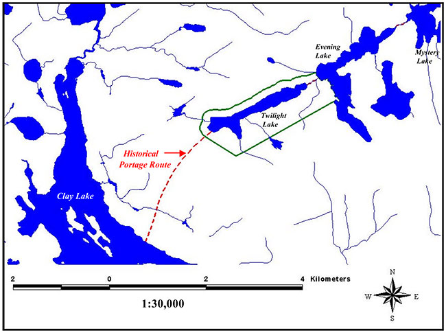
Enlarge The location of the historical portage route connecting Clay and Twilight Lakes.