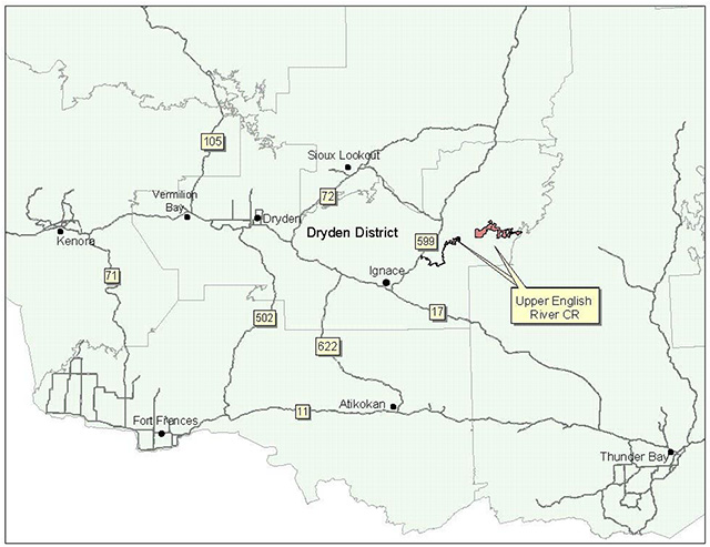
Upper English River Conservation Reserve Management Statement
This document provides policy direction for the protection, development and management of the Upper English River Conservation Reserve and its resources.
Statement of Conservation Interest (C2327)
June, 2003
Dryden District
Ministry of Natural Resources
Approval statement
We are pleased to approve this Statement of Conservation Interest for the Upper English River Conservation Reserve (C2327).
This Statement of Conservation Interest will provide guidance for the management of the Conservation Reserve and form the basis for ongoing monitoring of activities. More detailed direction is not anticipated at this time. Should significant facility development be considered or complex issues arise requiring additional studies, more defined management direction, or special protection measures, a more detailed Conservation Reserve Management Plan will be prepared with full public consultation.
The Upper English River Conservation Reserve will be managed under the jurisdiction of the Ignace Area supervisor, Dryden District, Ministry of Natural Resources.
Signed and approved by:
R.G. McColm
Dryden District Manager
Ministry of Natural Resources
Date: 30/06/2003
And,
Charlie Lauer
Regional Director
Northwest Region
Ministry of Natural Resources
Date: 03/07/2016
1.0 Background information
The purpose of this document is to identify and document the natural heritage values of the Upper English River Conservation Reserve, the activities that occur there and, through a set of management guidelines, lay out the activities that will and will not be permitted. For more information regarding this Statement of Conservation Interest (SCI) please refer to the "Conservation Reserve Policy and Procedure PL3.03.05".
Table 1.1: Background information for the Upper English River Conservation Reserve.
| Name | Upper English River Conservation Reserve (C2327) |
|---|---|
| Site Region / Site District | 4W1, 3W2 |
| OMNR Administrative Region / District / Area | Northwest Region / Dryden District / Ignace Area, English River Forest and Brightsand Forest |
| Total Area (ha) | 12,295 |
| Regulation Date | Anticipated for 2003 |
| First Nations | Ojibway Nation of the Saugeen Band, Wabigoon Lake Ojibway Nation, Aboriginal People of Wabigoon, |
| OBM | 20 15: 610054900, 620054900, 620054800, 630054900, 630055000, 640055000, 650055100, 650055000, 660055100, 660055000, 670055100, 670055000, 680055100 |
| Latitude / Longitude | 49' 41 N / 91' 04 W |
| Basemap | 61549, 62549, 62548, 63549, 63550, 64550, 65551, 65550, 66551, 66550, 67551, 67550, 68551 |
| General Location Description | The start of the reserve (at the bridge on Hwy. 599) is located approximately 32.5 km northeast of the Town of Ignace and approximately 105 km northeast of the City of Dryden (134 km by road). The reserve extends approximately 65 km heading east ending at Dove Lake. Some of the larger lakes (>1000 ha) the reserve borders include Sowden Lake and Shikag Lakes. |
| Access | Access to different portions of the reserve may be gained via Sowden Lk. Rd. and from the English River Bridge on Hwy. 599. Portages exist between all of the lakes from Frank’s Lake in the west to Pipio Lake in the east. |
Table 1.2: Representation Targets – A summary of earth science, life science, cultural resource values and present or possible recreational opportunities.
| Life science representation | Upland forest/forested dunes: Black spruce and jack pine on ground moraine. Trembling aspen and white birch on sandy soils. Mature white pine stands along river and lake shores. Upland cedar on rich clays. Wetland: Black ash and balsam poplar swamps on river floodplain. Thicket swamp and meadow marsh in wetter areas. Extensive wetlands including wild rice marshes. Aquatic habitat: Both lacustrine and riverine habitats. Most lakes shallow and mesotrophic; Pipio and English lakes are deeper and more oligotrophic Animal species: Moose, bear, wolf, beaver, eagle, osprey, loons, ruffed grouse, mallards, herons, various other fur-bearing mammals |
|---|---|
| Earth science representation | Bedrock: underlain with granitic and gneissic rocks of the central region of the Archean age Wabigoon Subprovince . Foliated to massive tonalite to granodiorite suite rocks found central and in the most eastern sections of the reserve as well. - two late Archean age batholiths containing mostly potassic, granite to granodiorite rock intersect the river. Surficial geology: The reserve is covered with silt and clay under glaciofluvial material deposited during glacial retreat. Glaciolacustrine clays and silts can be found on the north side of central Shikag Lake, at Eva Lake where the old CN rail line crosses the river and in the extreme downstream portion of the reserve. Shallow ground moraine over bedrock can be found at Pipio Lake, in the western portion of Shikag Lake and in sections of the river between MacKenzie and Frank’s lakes. Two systems of outwash plains with minor kame fields cross the reserve at the east end of Shikag and the west end of the reserve. |
| Cultural value representation | Artifact and pictograph sites along river. Numerous modern day campsites with associating man-made structures. |
| Recreational opportunities | Opportunities exist for fishing, camping, hunting, canoeing, portaging, berry picking, nature viewing and solitude activities. |
Table 1.3: Survey Information – Overview of inventories completed, their level of detail and any inventories that are needed.
| Survey Level | Life Science | Earth Science | Cultural | Recreational |
|---|---|---|---|---|
| Reconnaissance | checklist and Life Science Inventory - 2002 | checklist and Earth Science Inventory – 2002 | not required | check list and Recreation Inventory Report - 2002 |
| Detailed | not required | not required | not required | not required |
Figure 1: General location of the Upper English River Conservation Reserve.
Enlarge figure 1 general location of the Upper English River Conservation Reserve
2.0 Values to be protected
This section provides a description of the key natural heritage values on the site, their condition relative to past resource and management activities, and their sensitivity to future land use and management activities.
Table 2.1: Values identified on the Upper English River Conservation Reserve.
| Life science | Possible travel corridor and summer habitat along Shikag and Pipio Lakes for caribou. Significant large wild rice stands within the ecodistrict. The reserve contains several eagle and osprey nests. As well, Royal fern can be found along the riverbanks, indicating a natural flow regime. |
|---|---|
| Earth science | The reserve gives access to 3 of the dominant lithologic suites (considered regionally significant) |
| Cultural | Man-made structures (tables, fire pits, benches etc.) on camp/shorelunch areas throughout reserve |
| Aboriginal | Archaeological sites – pictographs, artifact sites |
| Tourism | Kozy Camp, Flayer’s Lodge Outpost, Moose Point Lodge, Ouisconsin Canoe Club, Northern Wilderness Outfitters |
| Recreational fishing | Permitted; sport fish include Walleye, Northern Pike and Bass |
| Recreational hunting | Permitted; WMU #15A; moose, deer, bear, waterfowl |
| Trapping | Permitted; trap lines: IG-24, IG-25, IG-37, IG-39, IG-40, IG-41, IG- 43, TB-194 |
| Bear Management Area | IG-15A-012, IG-15A-044 |
| Bait harvesting | Block #s: 61549, 62549, 62548, 63549, 63550, 64550, 65551, 65550, 66551, 66550, 67551, 67550, 68551 |
| Commercial fishing | In the past but not currently |
2.2 Values to be protected
The intent of this SCI is to protect the following values by establishing management guidelines for existing and potential uses in this area given the level of past disturbance and the nature of the existing features.
2.2.1 Forest values
No significant values were assigned to the forested areas within the reserve.
2.2.2 Biological values
Heavy woodland caribou activity was detected in the Shikag and Pipio Lake areas during aerial surveys conducted in the winters of 1988 and 1989 (Harris, 1990). The reserve itself does not contain any large core winter habitat blocks for caribou so these areas may act as travel corridors or summer habitat. The Upper English River Conservation Reserve contains significant riverine habitat and a representative section of a large free-flowing river system. The large wild rice stands on the lower river are considered significant in the ecodistrict. (Harris et al., 2002)
2.2.3 Landform values
The reserve crosses a large portion of the granitic and gneissic central region of the Wabigoon Subprovince giving access to three of the dominant lithologic suites. This was given regional significance. (Blackburn, 2002)
2.2.4 Recreational values
The Recreation Resource Inventory deemed the sport fish, the lakes and river, existing canoe route, traditional use route or trail, rapids and chutes, the general wildlife, sand beaches and general vegetation to be recreational features in this reserve. Present and potential recreation activities include canoeing, fishing, camping, hunting, portaging, berry picking, viewing and solitude. The traditional route/trail was considered to be most sensitive to recreation use as there runs the risk of damage to pictographs and sites where artifacts have been found. This sensitivity is considered low, however, due to the fact that the location of such sites will not be disclosed by MNR.
2.2.5 Tourism values
Seven Lodges/Resorts and outpost camps exist in or directly adjacent to the Upper English River Conservation Reserve as well as eight commercial boat caches (see Table 2.1). Services provided consist almost entirely of fishing and relaxation however there are some hunting groups that frequent the area in the fall.
2.2.6 Cultural values
An archaeological survey conducted in the late 1970s (Palette, 1980) indicated that the English River System was a minor water route for historic peoples. The survey itself extended from the southeast end of Minnitaki Lake passing through a number of lakes contained within the East English River Provincial Park and the parts of the Conservation Reserve, down the south shore of Mattawa Lake and through the English River to Selwyn Lake. The Conservation Reserve, however, diverges at Mattawa and extends northeast from Palette to Dove Lake. No known surveys exist for this portion of the reserve. Pictographs and artifact find sites can be found throughout the reserve, however, indicating travel through the latter area by historic peoples as well.
3.0 Management guidelines
3.1 Land tenure
The Upper English River Conservation Reserve consists entirely of and is mostly surrounded by Crown land. Some small private land parcels within the reserve boundaries have been excluded from the reserve itself. Additionally, the shoreline of Mattawa Lake has been completely excluded from the reserve as it is part of an Abitibi Freehold Block. Following the English River, west of the reserve, is the East English River Waterway Provincial Park. Directly east of the reserve is the Brightsand River Waterway Provincial Park.
Sale of lands is not permitted, except for minor dispositions in support of existing use (e.g. reconstruction of a septic system). Renewals of existing land use permits will be permitted. Requests for transfer of existing tenure located within the site will be considered, unless demonstrated conflicts exist.
The disposition of adjacent Crown land will be dealt with on a case-by-case basis.
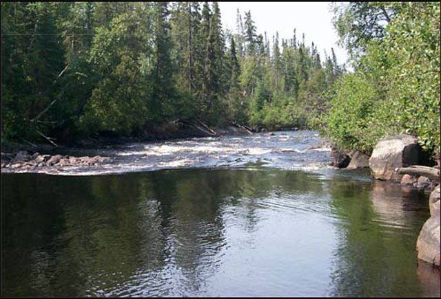
Figure 2: East rapids on English Lake.
Unauthorized occupations of lands within the Conservation Reserve will be handled in accordance with approved policy, and any required structural removal will be at the owner’s expense.
3.2 Existing and proposed development
The old CN Rail Line runs parallel to and then through the reserve. Currently it is being used for timber harvesting purposes south of the reserve. It is, however, privately owned and not for public use. A number of other secondary and forest access roads exist in the surrounding area. Additionally, several active pits can be found throughout the surrounding area.
Facility infrastructure and development for recreational and/or educational purposes may be considered in the future if there is a demonstrated demand for such facilities. All provincial policies that guide development on Crown Land are applicable in Conservation Reserves. A more detailed management plan would be required prior to any development occurring. Such a plan would have to ensure that there would be no negative impacts to any habitat or ecosystem pertinent to the values protected in this reserve.
3.3 Recreational activities
Most recreational activities that have traditionally been enjoyed in this area can continue provided they pose no threat to the natural ecosystems and features protected by the Conservation Reserve. Those uses that are regulated include hunting, fishing and trapping. Most other permitted activities are non-regulated (i.e. canoeing, exploring, snowmobiling). See Section 2.2.4 for the recreational uses for this Conservation Reserve as determined by the Recreation Resource Inventory. Additionally, there is at least one private recreation camp and 4 private boat caches within or immediately adjacent to the reserve.
Currently, four private (recreational) boat caches exist within the reserve. Recreational boat caches will continue to be a permitted use. New applications will be reviewed subject to a test of compatibility with the conservation of the ecological features of the site. In addition, the Northwest Region Boat Cache Program Guidelines will also apply.
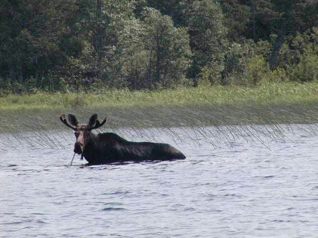
Figure 3: Bull moose feeding on Sowden Lake. (picture taken by Denis Smyk)
Mechanical travel within the reserve, including the use of snowmobiles and All Terrain Vehicles, is permitted only on existing roads and trails. Off trail mechanized travel is permitted for retrieval of game only.
3.4 Commercial activities
No new activities, such as commercial logging, hydroelectric power development, new transmission lines (e.g. power or communications), pipelines, highways or roads, and the extraction of minerals, aggregate or peat, will be permitted.
A non-Native commercial fishery last operated on Sowden Lake in 1996. The primary species harvested was whitefish, with lower incidental limits for walleye and northern pike. As already mentioned, seven lodges and outpost camps, as well as eight commercial boat caches exist within/around the boundaries of the reserve. The reserve also contains 4 trap cabins.
Resource user boat caches for the commercial harvest of natural resources (baitfish, commercial fur and wild rice) under a valid license, will continue to be a permitted use. New applications will be reviewed subject to the test of compatibility. Existing commercial boat caches (Tourism) will continue to be a permitted use unless there are significant demonstrated conflicts. In addition, the Northwest Region Boat Cache Guidelines will also be followed.
Boat caches only apply in the administrative area of the Northwest Boat Cache Program. This administrative line follows the former boundary between Ignace District Land Use Guideline Area #8 and Thunder Bay District Land Use Guideline Area #17.
An examination of the possible impact of activities on adjacent lands should be evaluated in the Forest Management Plan.
3.5 Aboriginal interests
Upper English River Conservation Reserve (C2340) lies within Treaty 3 area. To date, no Aboriginal Groups have voiced any issues in regards to this conservation reserve. Nothing in this Statement of Conservation Interest affects in any way existing or future Aboriginal or treaty rights.
3.6 Natural resources stewardship
Natural Resource Stewardship involves the consideration of the following specific natural resource management categories.
3.6.1 Vegetation management
Management within the conservation reserve will allow for the continuation of natural ecosystem processes and functions with minimal human interference.
Forest fire suppression will be carried out in accordance with the approved Fire Management Strategy for the surrounding lands. "Light on the Land" suppression techniques which do not unduly disturb the landscape will be encouraged where feasible. Examples of "light on the land" techniques may include limiting the number of trees felled or the use of heavy equipment or foam.
Opportunities for prescribed burning to achieve ecological or resource management objectives may be considered. These management objectives will be developed with public consultation prior to any prescribed burning, and reflected in the document that provides management direction for this conservation reserve. Plans for any prescribed burning will be developed in accordance with the MNR Prescribed Burn Planning Manual, and the Class Environmental Assessment for Provincial Parks and Conservation Reserves (approval pending).
3.6.2 Fish and wildlife management
The existing Wildlife Management Unit, sport fishing regulations and management activities will apply.
3.6.3 Landforms
None of the landforms mentioned will be altered by landform modification activities such as filling and extraction. The extraction of aggregates and similar materials are not permitted.
Mineral exploration and extraction are not permitted within the CR.
3.7 Cultural resources stewardship
An archaeological survey of the English River Area, which includes a portion of the Conservation Reserve, was completed in the late 1970s and incorporated into "Studies in West Patricia Archaeology No. 2: 1979-1980". Common knowledge of the area suggests there to be an abundance of such values on this site. A licensed archaeologist with extensive knowledge of the area was recruited to assist during the Recreation Inventory. Further Cultural Inventories were deemed unnecessary at the time.
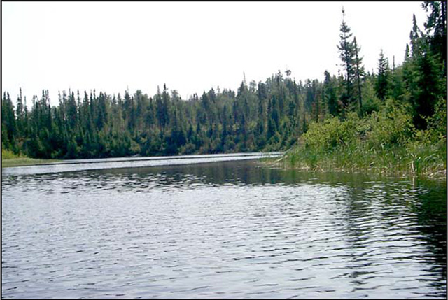
Figure 4: The English River east of Sowden Lake.
3.8 Client services
Given the focus on low key management, client information will be given on an inquiry basis only and will deal with the basic level of information with respect to access, natural heritage appreciation, recommended activities and boundaries.
3.9 Research
Non-destructive research by qualified individuals will be encouraged to provide a better understanding of the natural values protected by the Conservation Reserve and to advance protection, planning and management.
In order to assist with enhancing the management guidelines for the reserve, the collection of additional earth and life science information during research is encouraged.
All research programs will require the approval of the Ministry of Natural Resources as will the removal of any natural or cultural specimen. The establishment of permanent plots, observation points or facilities must also be approved and be compatible with the Conservation Reserve protection objective. Any site disturbed by research activities must be rehabilitated as closely as possible to its previous state.
3.10 Marketing
Awareness of the Conservation Reserve is promoted through the Living Legacy web site. Intensive management activity to increase use is not required at this time.
4.0 Implementation
Implementation of this Statement of Conservation Interest will primarily involve monitoring activities to ensure adherence to the management guidelines and responding to inquiries about the site.
Implementation of this statement and management of the reserve are the responsibility of the Ignace Area Supervisor. Partnerships may be pursued to address management needs.
5.0 Review and revisions
5.1 Review and revisions
This Conservation Reserve Statement of Conservation Interest will be reviewed on an ongoing basis.
If changes in management direction are needed at any time, the significance of the changes will be evaluated and further consultation a possibility. Any major amendments will require full public consultation and the approval of the District Manager and Regional Director. Affected clients will be immediately informed of proposed changes to this Statement of Conservation Interest.
5.2 Public consultation
5.2.1 Results of past consultations
Consultation on the Upper English River Conservation Reserve was conducted as part of the consultation on the Ontario’s Living Legacy Land Use Strategy, July 1999. Subsequent consultation also took place in September 2002 to refine the boundary of the Conservation Reserve.
District Manager letters, totaling 119, were sent to Bowater Canada Inc., Tourist Outfitters, Advisory Committees, Trappers, Land Owners, Members of the Public, Non-Government Organizations and Government Organizations. Newspaper ads were placed in the Ignace Driftwood September 25, 2002 and Dryden Observer on September 24, 2002.
First Nation Consultation letters were not sent out as direct consultation with Treaty 3 First Nations was carried out on a regional basis and concluded in November of 2002.
Concern about the effects of the reserve on private land owners was expressed. Issues were resolved during the consultation process. Thus, analysis of the issue was not needed.
5.2.2 Present and future consultation
More widespread consultation is not deemed necessary at this time.
5.2.3 Author
This Statement of Conservation Interest was prepared by Alicia H.L. Morin, OLL Intern, Information Management, Dryden District. Assistance was provided by Martin Pell (Dryden District Planner), members of the Ignace Area Team and John Carson (Dryden MNR
Enforcement, Ignace Area).
6.0 References
Blackburn, C. 2002. Earth Science Inventory – Upper English River Conservation Reserve – Draft. Unpublished report.
Harris, A. and Foster, R. 2002. Life Science Inventory – Upper English River Conservation Reserve – Draft. Unpublished report.
Ontario Ministry of Natural Resources (OMNR). 1999. Ontario’s Living Legacy – Land Use Strategy. Queen’s Printer for Ontario.
Ontario Ministry of Natural Resources. 2003. Upper English River Conservation Reserve (C2327) Recreation Resource Inventory Report. Unpublished report.
Ontario Ministry of Natural Resources, Lands & Natural Heritage, Lands & Waters. 1997. Conservation Reserve Policy and Procedure PL 3.03.05. 22 pp.
Pelleck, J.A. Archaeological Survey of the Upper English River. Studies in West Patricia Archaeology. No. 2: 1979-1980. Pp. 114-130. (edited by Reid, C.S. and Ross, W.A. of Historical Planning and Research Branch, Ontario Ministry of Culture and Recreation, 1981).
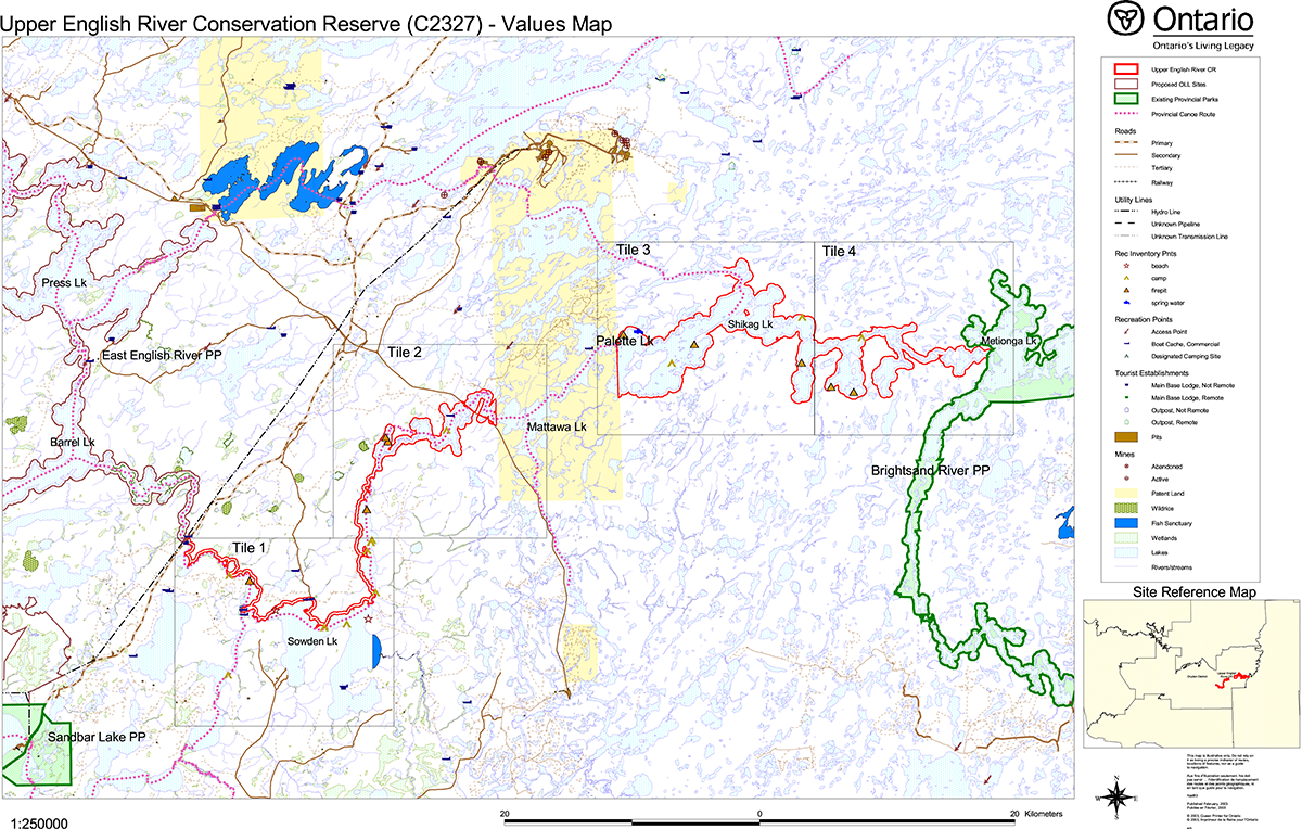
Appendix A: Upper English River Conservation Reserve (C2327) values map
Upper English River Conservation Reserve (C2327) – Values Map
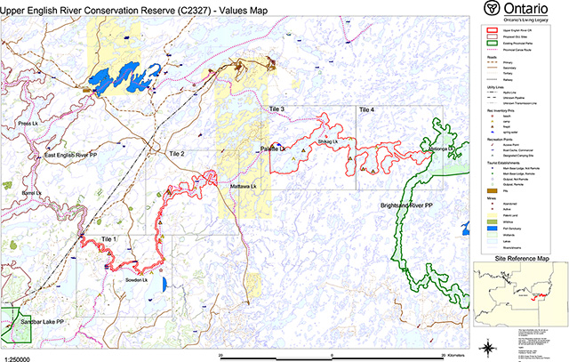
Enlarge Upper English River Conservation Reserve (C2327) – Values Map
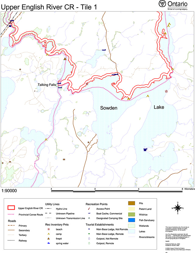
Upper English River CR - Tile 1
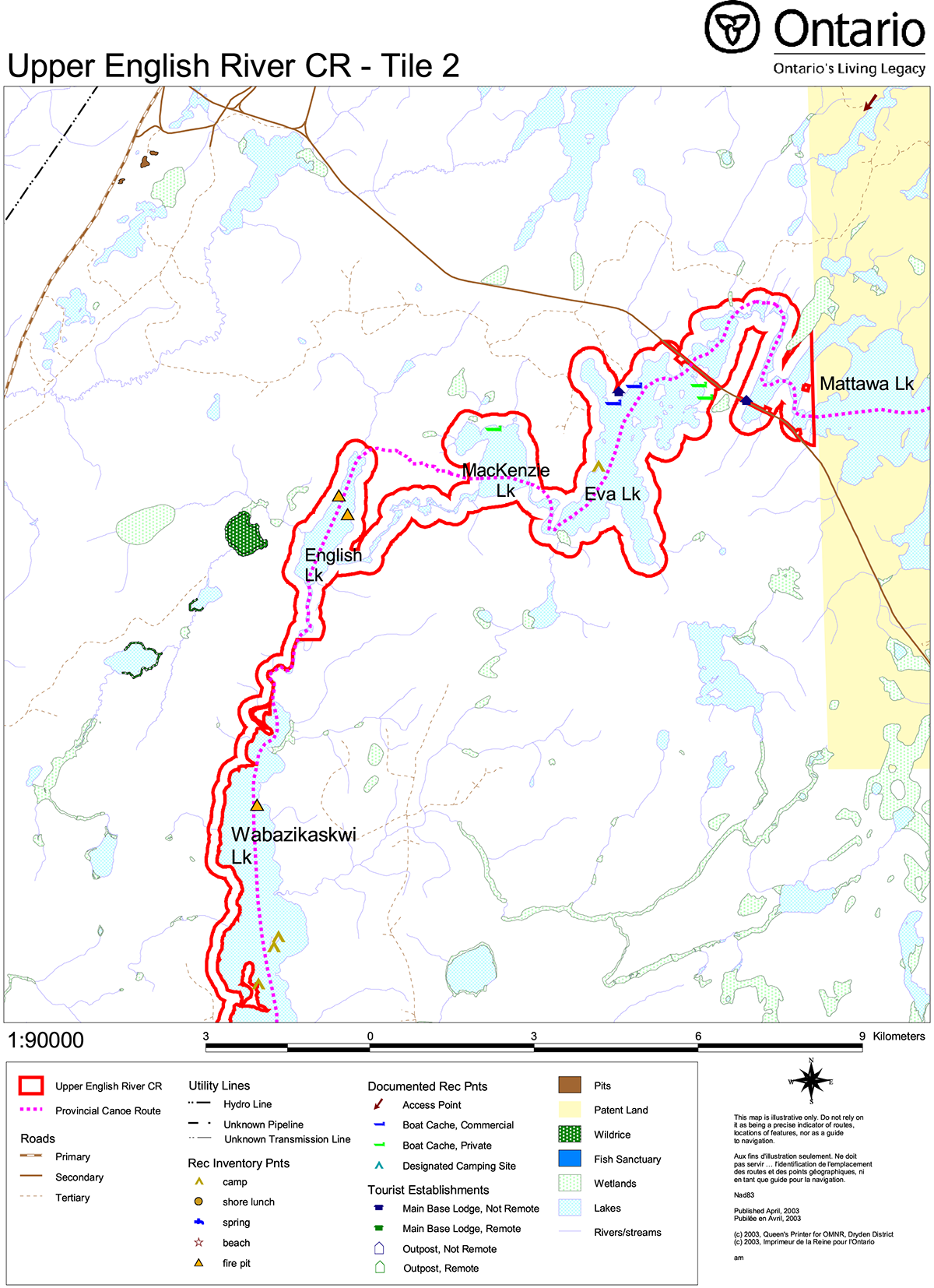
Upper English River CR - Tile 2
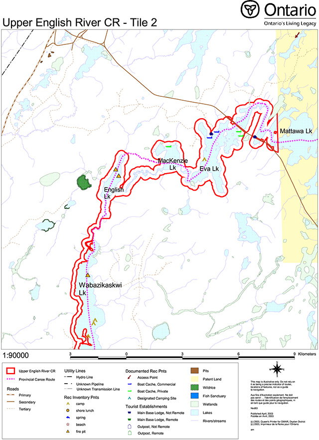
Enlarge tile 2: Upper English River Conservation Reserve (C2327) – Values Map
Upper English River CR - Tile 3
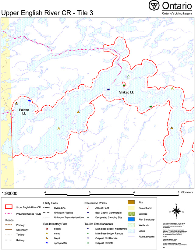
Enlarge tile 3: Upper English River Conservation Reserve (C2327) – Values Map
Upper English River CR - Tile 4
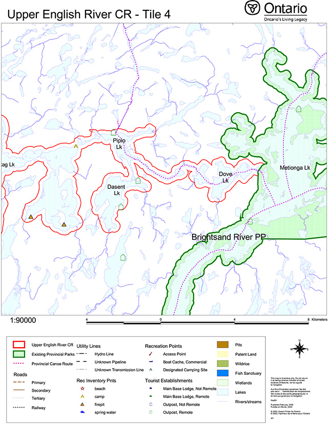
Enlarge tile 4: Upper English River Conservation Reserve (C2327) – Values Map
Appendix B: Upper English River Conservation Reserve (C2327) Earth Science Checksheet
C2327 Upper English River
Detailed information for Site C2327 Upper English River
Protection history
The reserve was identified under the provincial Lands for Life - Ontario’s Living Legacy Program as containing "representative landscape features and providing a waterway linkage from the Brightsand River Provincial Park to the English River system." (OMNR 1999).
No other earth science significance was assigned.
Setting
Upper English River Conservation Reserve runs from the outlet of Metionga Lake into Dove Lake in the east to where Highway 599 crosses the English River in the west, a distance of approximately 65 km. The reserve includes Dasent, Pipio, Shikag, Palette, Eva, MacKenzie, English, Wabazikaskwi and Sowden lakes. Excluded is a portion of the river system in the centre portion of the Reserve that includes Cutstone and Mattawa lakes, where it passes through private land known as Abitibi Block No. 7. The reserve consists of a 200 m wide buffer around the river and associated lakes, except at the west end where only the west shore of Wabazikaskwi Lake and the north shores of Sowden Lake and the river to Highway 599 bridge are included.
The reserve comprises 12 312 hectares, all located in Dryden MNR District.
Earth science features
Bedrock geology
Much of the region through which the Upper English River Conservation Reserve waterway passes has only been mapped by government geological surveys at very broad regional scale. The portion between Metionga Lake and Block No. 7 was included in a regional mapping program at 1:63 360 scale in the 1960s (Rogers 1964), and is somewhat outdated. No systematic mapping has been done of the portion downstream of Abitibi Block No. 7. Only the portion of the waterway downstream of Sowden Lake was visited in the field during the present reconnaissance inventory. The following account is based largely on study of Map 2044 (Rogers 1964), Map 2442 (OGS 1980), Map 2542 (OGS 1991) and Map 2576 (OGS 1992).
The reserve lies entirely within granitic and gneissic rocks of the central region (Blackburn et al 1991) of the Archean age Wabigoon Subprovince. Three suites of rocks are present. Two older suites, of Middle to Late Archean age, are dominant within the reserve. A suite of granitic gneisses underlies most of the area between the central part of Shikag Lake in the east and central Sowden Lake in the west, but interrupted in the middle section, from the west end of Mattawa Lake to central Wabazikaskwi Lake, by foliated to massive tonalite to granodiorite suite rocks. The regional trend of gneissosity at Shikag Lake is to the southwest, accounting for the same trend of the main arm of the lake. Gneisses were observed near Sowden Lake (stations 6 and 7). Here the gneisses are granitic, with mafic amphibolite layers and lenses, and the gneissosity is cut by later aplite and pegmatite dikes (photo 1). As well as the section within the gneissic suite, foliated tonalite to granodiorite suite rocks also underlie the extreme east section of the reserve, from the west end of the Brightsand River Provincial Park at Metionga Lake, through Dove Lake to Pipio Lake.
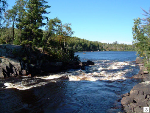
Portions of two late Archean age batholiths are crossed by the waterway. Rocks of these batholiths are of more potassic, granite to granodiorite, composition than the earlier foliated tonalite to granodiorite suite. Rocks of one of these batholiths, delineated on Maps 2542 and 2576 (OGS 1991 and 1992), underlie Dasent Lake and the two large bays at the east end of Shikag Lake. This writer knows of no name given to the batholith, and it is here named the Dasent Lake batholith. A small portion of the second batholith, the Indian Lake batholith, is crossed by the waterway at the west end of the reserve. Only a small portion at its extreme north end is represented: the batholith extends from Sowden Lake westward to Mameigwess Lake, and to Ignace in the south (OGS 1991, 1992). The batholith is characteristically granodioritic, with potassic feldspar megacrysts (Blackburn et al 1991). Outcrops investigated during the present inventory (stations 2 and 5) are of massive, non-foliated, medium to coarse-grained granodiorite to quartz monzonite. At station 2, on a forest access road just outside the reserve boundary (photo 2), hornblende is dominant. At Talking Falls (station 5: photo 3) the mafic mineral is biotite.
Surficial geology
Because only the portion of the waterway downstream of Sowden Lake was visited in the field during the present reconnaissance inventory, the present account is based largely on study of Engineering Geology Terrain Study Maps (Mollard 1980a, b).
Following deposition of till, about 11 000 years ago during the Late Wisconsinan stage, Pleistocene period, silt and clay were deposited in glacial Lake Agassiz. These are overlain by glaciofluvial material deposited during glacial retreat. Recent organic deposits are also represented.
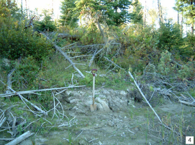
Glaciolacustrine clays and silts occur at three places in the reserve. One is on the north side of the central portion of Shikag Lake. A second is at Eva Lake, where the Canadian National Railway line crosses the English River. The third is in the extreme downstream portion of the reserve, between Pinaemodal Lake and the Highway 599 crossing. In this latter section a 4 m high clay bank was observed at station 9 (photo 4), and silty clay was augured to a depth of 0.5 m at station 8. No layering indicative of varves was encountered.
Shallow till over bedrock predominates at Pipio Lake in the east, in the western portion of Shikag Lake, and in the section of the river between the rapids exiting from MacKenzie Lake and Franks Lake just below Talking Falls.
Glaciofluvial deposits are predominantly oriented in a northeast to southwest direction. They are mostly interpreted (Mollard 1980a, b) to be outwash plains, with minor kame fields. Two systems cross the reserve area. The most prominent is at the east end of Shikag Lake, where a 10 km section of the river system crosses an outwash plain. A number of esker ridges follow this outwash plain, mostly outside the confines of the 200 metre reserve along shorelines. The second, a considerably smaller system, is at the west end of the waterway reserve, adjacent to the area of glaciolacustrine deposits. A kame field is interpreted (Mollard 1980a) in this system to the north of the 200 metre reserve along the shoreline (station 4: photo 5).
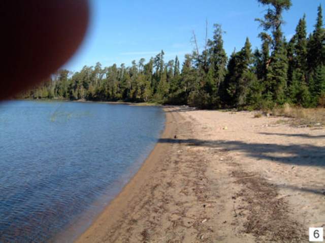
Recent deposits are not prominent. Organic terrain is present on the north side of Shikag Lake in its central section, while the present survey encountered sand beaches, particularly on the north side of Sowden Lake where a 100 m long beach (station 1: photo 6) faces toward the west, the prevailing storm wind direction.
Significance
The portion of the English River that constitutes Upper English River Conservation Reserve crosses a considerable portion of the granitic and gneissic central region of the Wabigoon Subprovince. It gives access to three of the dominant lithologic suites. It is considered to be of regional significance.
Because much of the waterway was not accessed, no rating can be given by the present surveyor of the relative importance of the surficial materials of the reserve.
Sensitivity
Bedrock features are not subject to degradation by either human activity or natural processes. Surficial deposits, such as the outwash deposits and eskers where present, may be subject to degradation by disturbance of vegetation cover and by exploitation for gravel construction materials. Natural processes, such as C2327 Upper English River erosion along lakeshores, are unlikely to degrade these features by anything but minimal amounts. They do in fact serve to keep the internal architecture of eskers exposed.
Recommendations
Conservation Reserve status adequately protects the earth science features present in Upper English River Conservation Reserve.
References
Mollard, D.G. 1980a. Press Lake, Data Base Map, Northern Ontario Engineering Geology Terrain Study; Ontario Geological Survey, Map 5062, scale 1:100 000.
Mollard, D.G. 1980b. Metionga Lake, Data Base Map, Northern Ontario Engineering Geology Terrain Study; Ontario Geological Survey, Map 5063, scale 1:100 000.
OGS 1980. Sioux Lookout - Armstrong, Districts of Kenora and Thunder Bay, Geological Compilation Series; Ontario Geological Survey, Map 2442, scale 1:253 440.
OGS 1991. Bedrock Geology of Ontario, west-central sheet; Ontario Geological Survey, Map 2542, scale 1:1 000 000.
OGS 1992. Tectonic Assemblages of Ontario, west-central sheet; Ontario Geological Survey, Map 2576, scale 1:1 000 000.
Rogers, D.W. 1964. Metionga Lake area; Ontario Geological Survey, Map 2044, scale 1:63 360.
OMNR 1999. Ontario’s Living Legacy: Land Use Strategy; Ontario Ministry of Natural Resources, 136 p., accompanied by map, scale 1:1 200 000.
Photographs
1. Granitic gneiss with amphibolite layers and xenoliths, cut by aplite Near Sowden Lake. (Stn. 6; UTM 0622779E 5493272N)
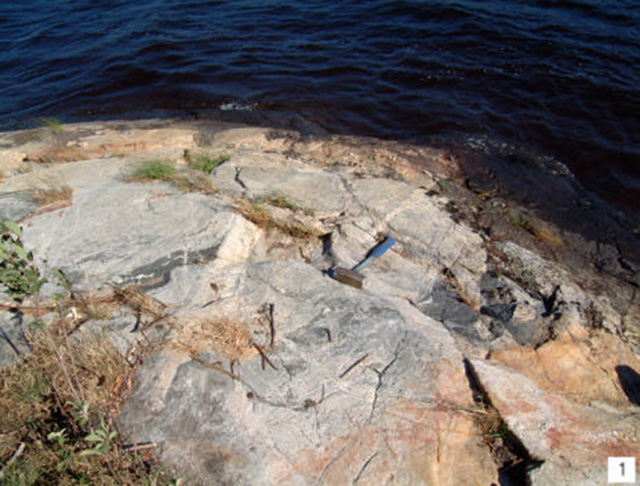
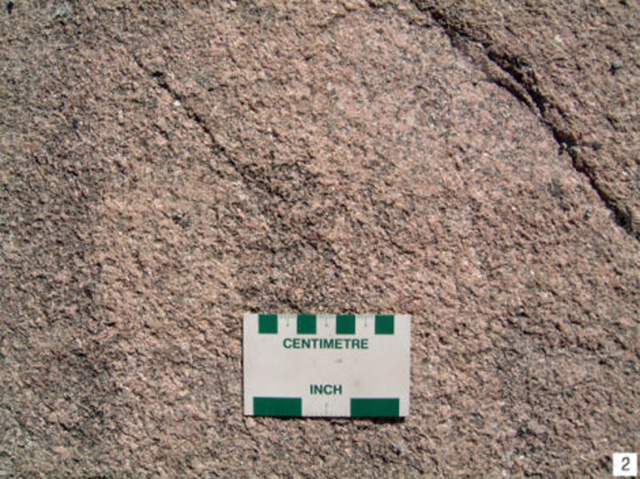
2. Massive, medium grained granodiorite to quartz monzonite of the Indian Lake batholith. Near Sowden Lake. (Stn. 2; UTM 0628596E 5491395N)
3. View downstream at Talking Falls, west of Sowden Lake. (Stn. 5; UTM 0622070E 5490841N)
4. Four metre high clay bank exposed on the north side of the English River between Pinaemodal Lake and the Highway 599 bridge. (Stn. 9; UTM 0618672E 5494899N)
5. Unbedded, cobble-to sand-sized deposit of probable kame or esker origin. Gravel pit on east side of Sowden Lake forest access road north of the (Stn. 4; UTM 0626538E 5495464N)
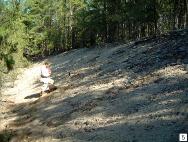
6. Sand beach at boat launch into Sowden Lake, 14 km down forest access road from Highway 599. (Stn. 1; UTM 0627716E 5491433N)
Additional stations
Stn. 3 UTM 0627745E 5491778N
Stn. 7 UTM 0621501E 5493982N
Stn. 8 UTM 0620529E 5494608E
Earth science inventory checklist
| Name | Upper English River |
|---|---|
| OLL ID | C2327 |
| Map name | Empire Lake, Shika |
| NTS Number | 52G/09,10,11,15 |
| UTM reference | Z15 639000E 550 |
| OBM number | |
| Latitude | 49° 41' N |
| Longitude | 92° 00' W |
| Elevation – Max | 460 m |
| Elevation – Min | 401 m |
| County | District of Kenora |
| Township | unorganized |
| Lot | N/A |
| Concession | N/A |
| Area (ha) | 12,312.00 |
| Ownership | Crown |
| Air photo Year - Roll - Flight Line - Number |
96-37-4919B-27 to 34;96-37-4920B-78 to 82+84-87;96-25-4921B-12 to 14;96-23-4922B-175 to 177;96-44- |
| MNR region | Northwest |
| MNR district | Dryden |
| Park zone | Northwest |
Location Map of Upper English River Conservation Reserve (C2327)
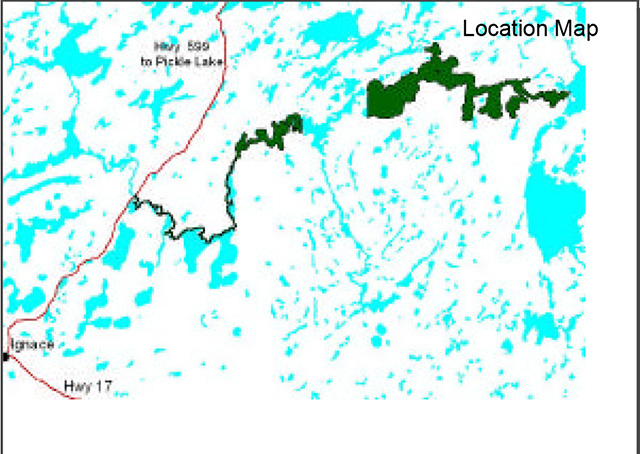
Enlarge Location Map of Upper English River Conservation Reserve (C2327)
Earth science features
Archean age Wabigoon Subprovince: granitic and gneissic rocks. Three suites: 1) Middle to Late Archean granitic gneisses; 2) Middle to Late Archean tonalite to granodiorite; 3) Late Archean granite to granodiorite. Suite 3 represented by portions of Indian Lake and Dasent Lake bathoiliths.
Pleistocene age, Late Wisconsinan stage: glaciolacustrine clays and silts; shallow till; two systems of glaciofluvial outwash plains, kame fields, esker ridges. Minor Recent organic terrain, sand beaches.
Significance
Reserve crosses a considerable portion of the granitic and gneissic central region of the Wabigoon Subprovince - regional significance.
Surficial materials not rated.
Sensitivity
No features or landforms sensitive to natural impacts. Outwash deposits and eskers may be sensitive to cultural impacts (exploitation for gravel construction materials).
Recommendations
Conservation Reserve status adequately protects earth science features.
Major references
Mollard 1980, OGS Maps 5062 and 5063; OGS 1980, Map 2442; OGS 1991, Map 2542; OGS 1992, Map 2576; Rogers 1964, OGS Map 2044.
Date compiled
February 15, 2003
Compiler
C.E. Blackburn, Blackburn Geological Services
Ontario Ministry of Natural Resources, Ontario Parks
300 Water Street, Peterborough, Ontario K9J 8N1
Appendix C: Upper English River Conservation Reserve (C2327) Life Science Checksheet
C2327 Upper English River
Natural Heritage Area – Life Science Checksheet
| Name | Upper English River |
|---|---|
| Map Name | Empire Lake Shikag Lake Mattabi Glitter Lake |
| Map Number | 52G9 52G10 52G11 52G15 |
| UTM Reference | Zone 15 639000 E 5505000 N |
| County | Kenora |
| Latitude | 49 41' N |
| Longitude | 91 04' W |
| NAD | 83 |
| Min. Alt. | 401 m |
| Max. Alt. | 460 m |
| Locality | 30 km northeast of Ignace |
| Township | unorganized |
| Area | 12,312 ha |
| Ownership | Crown |
| MNR Region | Northwest |
| Ecoregion and Ecodistrict | 3W-2 |
| Landform Unit | See Table 3 |
| MNR District | Dryden, Thunder Bay |
| Aerial Photographs Year-Roll-Flight Line-Numbers | 96-37-4919B-27 to 34 96-37-4920B-78 to 82+84-87 96-25-4921B-12 to 14 96-23-4922B-175 to 177 96-44-4923-138 to 144 96-28-4924-229 to 233+237 to 254 96-28-4925-158 to 174 96-16-4926-90 to 96 96-28-4927-70,71 |
Location Map of Upper English River Conservation Reserve (C2327)
Enlarge Location Map of Upper English River Conservation Reserve (C2327)
Physical and biological features
The Upper English River Conservation Reserve covers 12,312 hectares, consisting of a 200 m wide buffer around the English River and associated lakes. It encompasses approximately 65 kilometers of the English River, extending from Highway 599 in the west and ending at Dove Lake in the east. The Conservation Reserve is divided into east and west portions by a large block of private land between Palette Lake and Eva Lake. The eastern portion of the site includes all of Dove Lake, Dasent Lake, Shikag Lake and most of Palette Lake. The western section of the conservation reserve includes all of Eva Lake, English Lake and MacKenzie Lake, and the west shore of Wabazikaskwi Lake and the north shores of Sowden Lake and Frank’s Lake to the Highway 599 bridge.
Upper English River Conservation Reserve has a wide range of glacial landforms and associated forest conditions. The lower part of the Conservation Reserve (downstream of Frank’s Lake) has glaciolacustrine silt and clay soils supporting rich, trembling aspen-dominated mixed forests (ES29). Black ash and balsam poplar swamps (ES38) are frequent on the river floodplain along with thicket swamps (ES44) and meadow marsh (ES46) in wetter areas. Upland cedar stands (ES17) are also found on the rich clays. Some recent fluvial deposits are found on the river floodplain.
Farther upstream, the landscape becomes dominated by black spruce and jack pine on ground moraine (ES13, ES14, ES20) and shallow soils (ES12). Patches of outwash and lacustrine deposits are found throughout the area. An extensive area of glacial outwash around Shikag Lake supports jack pine and black spruce with variable amounts of trembling aspen and white birch on sandy soils (ES13, ES14).
Mature white pine stands are restricted to warmer than average sites along the river and on lakeshores. One such stand at Talking Falls had shallow silty loam soil with a dense understorey of mountain maple and other tall shrubs (ES24).
Table 1. Ecosites of Upper English River Conservation Reserve (derived from Forest Resource Inventory data provided by OMNR).
Very shallow soils
| Description | Area (ha) | Proportion (%)* | |
|---|---|---|---|
| ES12 | Black Spruce - Jack Pine: Very Shallow Soil | 35 | 1 |
| ES13 | Jack Pine-Conifer: Dry-Moderately Fresh, Sandy Soil | 62 | 1 |
Sandy-coarse loamy soils
| Description | Area (ha) | Proportion (%)* | |
|---|---|---|---|
| ES14 | Pine-Spruce Mixedwood: Sandy Soil | 74 | 1 |
| ES16 | Hardwood - Fir - Spruce Mixedwood: Sandy Soil | 51 | 1 |
| ES17 | White Cedar: Fresh - Moist, Coarse - Fine Loamy Soil | 36 | 1 |
| ES19 | Hardwood - Fir - Spruce Mixedwood: Fresh, Sandy - Coarse Loamy Soil | 1066 | 19 |
| ES20 | Spruce - Pine / Feathermoss: Fresh, Sandy - Coarse Loamy Soil | 637 | 12 |
| ES21 | Spruce - Fir Mixedwood: Fresh, Coarse Loamy Soil | 2178 | 40 |
| ES22 | Spruce-Pine / Ledum / Feathermoss: Moist, Sandy-Coarse Loamy Soil | 502 | 9 |
| ES23 | Hardwood Fir – Spruce Mixedwood: Moist, Sandy-Coarse Loamy Soil | 135 | 2 |
Fine loamy – clayey soils
| Description | Area (ha) | Proportion (%)* | |
|---|---|---|---|
| ES25 | Pine – Spruce / Feathermoss: Fresh, Silty Soil | 20 | <1 |
| ES26 | Spruce - Pine / Feathermoss: Fresh, Fine Loamy - Clayey Soil | 2 | <1 |
| ES27 | Fir - Spruce Mixedwood: Fresh, Silty - Fine Loamy Soil | 11 | <1 |
| ES28 | Hardwood-Fir-Spruce Mixedwood: Fresh, Silty Soil | 39 | 1 |
| ES29 | Hardwood - Fir - Spruce Mixedwood: Fresh, Fine Loamy - Clayey Soil | 1 | <1 |
| ES31 | Spruce-Pine / Feathermoss: Moist, Silty-Clayey Soil | 11 | <1 |
| ES32 | Fir - Spruce Mixedwood: Moist, Silty - Clayey Soil | 108 | 2 |
| ES33 | Hardwood - Fir - Spruce Mixedwood: Moist, Silty - Clayey Soil | 115 | 2 |
Treed wetlands
| Description | Area (ha) | Proportion (%)* | |
|---|---|---|---|
| ES35 | Poor Swamp: Black Spruce: Organic Soil | 222 | 4 |
| ES36 | Intermediate Swamp: Black Spruce (Tamarack): Organic Soil | 160 | 3 |
| ES37 | Rich Swamp: Cedar (Other Conifer): Organic Soil | 4 | <1 |
*terrestrial area only
Most of the Conservation Reserve is comprised of water. Waterbodies include the English River and interconnected lakes: Dove, Pipio, Shikag, Dasent, Palette, Eva, MacKenzie, English, Wabazikaskwi, Sowden, and Frank’s lakes.
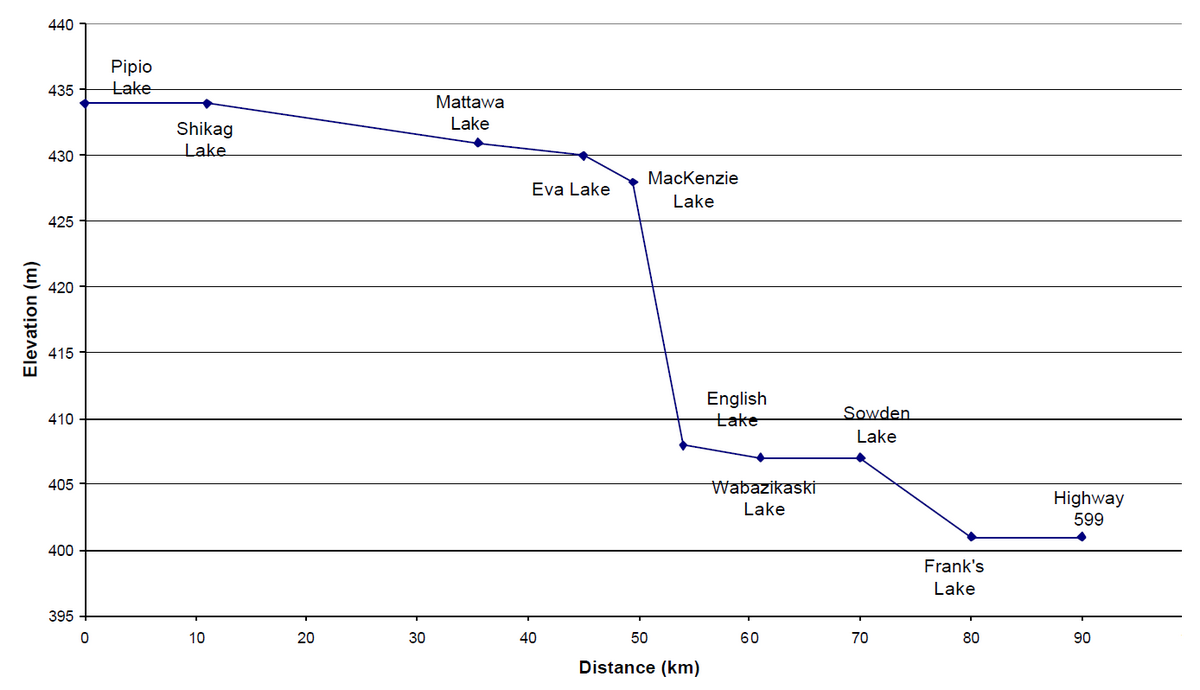
The reserve spans two watersheds: Dove Lake flows east into the Brightsand River watershed; the rest of the area flows west into the English River watershed. The English River flows into the south side of Mattawa Lake, outside the reserve. Elevation drops about 30 m over the waterway with the greatest drop at a set of rapids between MacKenzie and English lakes (Figure 1).
Figure 1. Elevation profile of Upper English River Conservation Reserve.
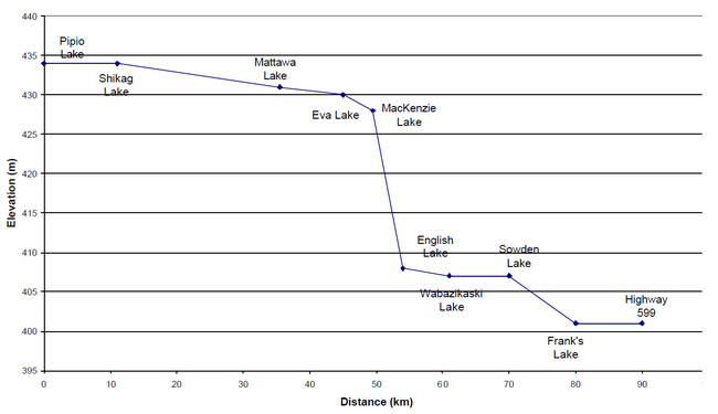
Enlarge Figure 1. Elevation profile of Upper English River Conservation Reserve
The aquatic environment includes both lacustrine and riverine habitats. Most lakes are relatively shallow and mesotrophic (morphoedaphic index values of 3.6 to 16.7) (Table 2). Pipio and English lakes are deeper and more oligotrophic (morphoedaphic index values = 2.3 to 2.8). Downstream, the English River flows through fine textured silty and clay soils, increasing turbidity and nutrient levels in the lakes Bedrock and boulder shores predominate upstream of Sowden Lake. Eroding clay banks are frequent on the lower stretch of the river where it flows through lacustrine soils. Extensive wetlands, including wild rice marshes, are common on the lower part of the river. Royal fern, an indicator of natural water regime, is present on the riverbanks.
Table 2. Physical parameters of major lakes in Upper English River Conservation Reserve (data from Aquatic Habitat Inventory database, OMNR)
| Area (ha) | Littoral Zone (%) | Max Depth (m) | Mean Depth (m) | Perimeter (km) | Morpho-edaphic Index | Secchi Depth (m) | |
|---|---|---|---|---|---|---|---|
| Pipio Lake | 152 | - | 16.0 | 7.4 | 13.3 | 2.8 | 3 |
| Shikag Lake | 4527 | 88 | 19.5 | 2.4 | 118.3 | 11.4 | 1.4 |
| Eva Lake | 436 | 84 | 12.8 | 3.7 | 23.2 | 5.9 | 2 |
| English Lake | 109 | 43 | 22.6 | 9.5 | 7.1 | 2.3 | 2 |
| Wabazikaskwi Lake | 695 | 62 | 15.6 | 5.2 | 31.5 | 4.2 | 2 |
| Sowden Lake | 3719 | 48 | 18.3 | 6.3 | 50.2 | 3.6 | 2 |
Representation
Table 4 summarizes representation of landform vegetation types of the Upper English River Conservation Reserve for Ecodistrict 3W-2 recently refined by Ontario Parks (Steve Kingston pers. comm.). An older version of the landform vegetation representation matrix based on the original Ontario Living Legacy gap analysis is included for comparison (Table 5).
Table 4 accurately reflects the high diversity of LV types within Upper English River Conservation Reserve. Among the LV types not confirmed in the field are those on Glaciofluvial Ice Contact Deposits deposits. These LV types are associated with kame fields, none of which were confirmed in the field, but which probably exist in inaccessible portions of the reserve. Treed bogs were not confirmed in the field. Total area of treed bog is less than 30 ha, occurring in small dispersed patches, and may be misclassified conifer swamp.
The Conservation Reserve contributes little to representation targets (less than 10% of any Ecodistrict target; Table 4) due to the high diversity of landforms and vegetation types, but relatively little area of any particular LV type.
Upper English River contains a representative section of a free-flowing large river system and the associated marshes and shoreline habitats.
Condition
Upper English River receives moderately heavy use by anglers near access points, but rapids on the river restrict boat access to some sections of river. Public access points are at the bridge on Highway 599 and at the north end of Sowden Lake. A former rail line, now a private road, crosses the Conservation Reserve at Eva Lake.
Commercial fishing apparently took place on Wabazikaski Lake in the 1960's (OMNR lake survey data).
The area surrounding the Conservation Reserve is under active forest management and is largely surrounded by cutover and logging roads. There is no evident cutover within the reserve and it has been surrounded by buffers to protect fish habitat, water quality and tourism values for many years.
Diversity
Upper English River Conservation Reserve has a wide range of forest conditions associated with the diverse glacial landforms. A total of 32 LV types ( Table 4) and 26 ecosites (Table 1, Table 3) are represented.
The influence of the English River contributes to the diversity of habitats. The river floodplain has warmer than average microclimate and rich alluvial soils. Wetlands and the riparian environment add variability to the vegetation. The English River itself is made up diverse habitats including fast moving stretches with riffles, falls, and pools, as well as slow moving stretches with wild rice and other marsh vegetation.
Ecological function
Upper English River Conservation Reserve makes a l ink between Brightsand River Provincial Park and East English River Provincial Park, completing a band of almost continuous protected habitat along waterways joining Lake Nipigon, Wabikimi Provincial Park and Lac Seul.
Although the Conservation Reserve encompasses a relatively large area, its narrow, linear arrangement results in high degree of edge with virtually no core forest habitat needed by marten, woodland caribou and other area-sensitive species. Maintaining these species will depend on forest management practices in the surrounding forest.
Only one shore of some of the lakes is protected, leaving these water bodies vulnerable to changes in water quality and human use from outside the Conservation Reserve.
Special features
The south end of the Upper English River Conservation Reserve marks the southern limit of woodland caribou ( S3S4?) range in northwestern Ontario. Aerial surveys found heavy woodland caribou activity in the Pipio and Shikag lakes area in the winters of 1988 and 1989 (Harris 1990). Although the Conservation Reserve does not contribute large core winter habitat blocks for caribou, it may protect travel corridors and summer habitat along Pipio and Shikag lakes.
Three bald eagle (S4B) nests and several osprey nests occur in the Conservation Reserve and several archaeological sites, including pictographs are present (OMNR 2002).
The Upper English River is a significant riverine habitat containing a representative section of a free-flowing large river system. The large wild rice stands on the lower river are significant in the ecodistrict.
Recommendations
- In order to protect shoreline communities and riverine processes, dams or other water regulation structures should not be installed in the conservation reserve nor outside its boundaries if they would affect water levels or conditions inside the
- Conservation Reserve managers should continue to actively participate in the English River Forest management planning
Significance level and summary of major representative values
Upper English River Conservation Reserve is provincially significant due to it high diversity of landform vegetation types ( Table 4). The Conservation Reserve marks the southern limit of woodland caribou range and may protect travel corridors and summer habitat along the waterway.
This section of the English River system is significant in that, unlike most large river systems in northwestern Ontario, it is uninfluenced by water level regulation by dams.
Major information sources
Harris, A.G. 1990. Woodland caribou studies and habitat management plan for the Brightsand Forest. Unpub. Rep.. Ontario Ministry of Natural Resources. Ignace District. 93 pp.
Harris, A.G., S.C.McMurray, P.W.C.Uhlig, J.K.Jeglum, R.F.Foster and G.D. Racey. 1996. Field guide to the wetland ecosystem classification for northwestern Ontario. Ont. Min. Natur. Resour., Northwest Sci. & Technol. Thunder Bay, Ont. Field Guide FG-01. 74 pp. + Append.
OMNR. 2002. Upper English River Conservation Reserve Factsheet.
OMNR. 1999. Ontario’s Living Legacy – Land Use Strategy. Queen’s Printer, Toronto.
Racey, G.D., A.G. Harris, J.K. Jeglum, R.F. Foster and G.M.Wickware. 1996. Terrestrial and wetland ecosites of northwestern Ontario. Ont. Min. Natur. Resour., Northwest Sci. & Technol. Thunder Bay, Ont. Field Guide FG-02. 88 pp. + Append.
Sims, R.A., W.D. Towill, K.A. Baldwin, P. Uhlig and G.M. Wickware. 1997. Field guide to the forested ecosystem classification for northwestern Ontario. Ont. Min. Natur. Resour., Northwest Sci. & Technol. Thunder Bay, Ont. Field Guide FG-03. 176 p.
Date Compiled: February 24, 2003
Compilers: Allan Harris and Robert Foster, Northern Bioscience
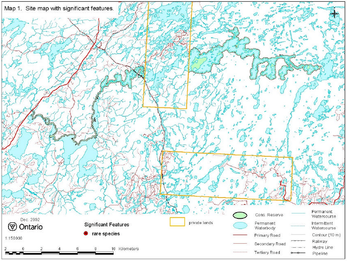
Map 1. Site map with Significant features.
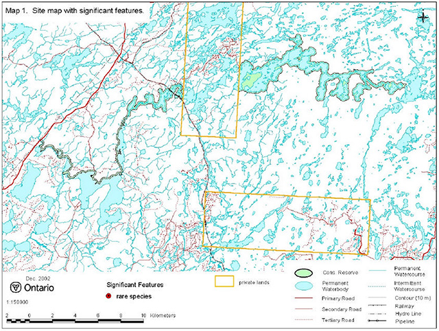
Enlarge map 1. Site map with Significant features.
Photo 1. Talking Falls, English River.

Photo 2. Sand beach on Sowden Lake.
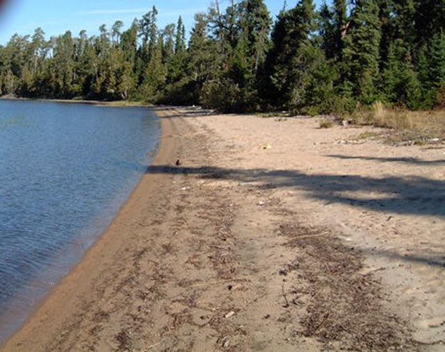
Photo 3. Rich mixed forest.
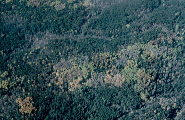
Photo 4. Rich mixed forest.
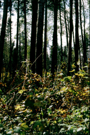
Photo 5. Exposed silty bank on the English River.
Photo 6. Shore fen community.
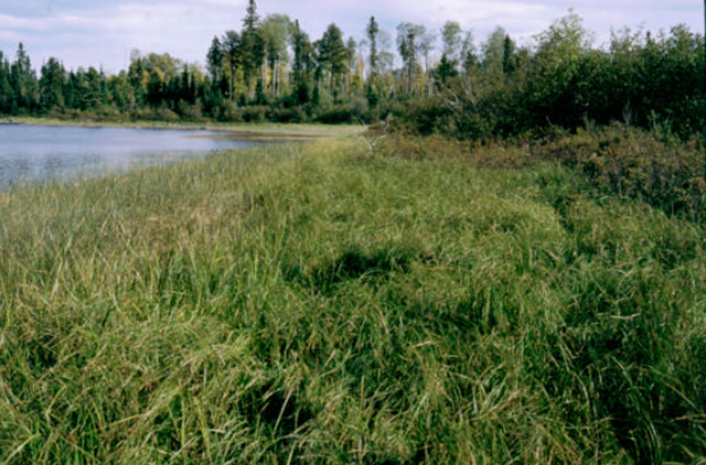
Table 3. Rapid assessment plot summary from Upper English River.
| Plot No. | V/W Type | ES Type | Date |
|---|---|---|---|
| 1 | W7 | ES48 | September 17, 2002 |
| 2 | V4 | ES16 | September 17, 2002 |
| 3 | W9 | ES47 | September 17, 2002 |
| 4 | V12 | ES24 | September 17, 2002 |
| 5 | V21 | ES17 | September 17, 2002 |
| 6 | W12 | ES46 | September 17, 2002 |
| 7 | V2 | ES38 | September 17, 2002 |
Table 4. Landform - vegetation (LV) type representation for Upper English River in Ecodistrict 3W-2 (analysis by Ontario Parks; Steve Kingston pers. comm.).*
| LV Description | Ecodistrict 3W2: Area (ha) | Ecodistrict 3W2: Representation Target % | Ecodistrict 3W2: Representation Target ha | Ecodistrict 3W2: Protected Areas (ha) | Upper English River Area (ha) | Upper English River Contribution to Ecodistrict Target (%) | Upper English River Contribution to Existing Protection (%) | Upper English River Confirmed in Field ** |
|---|---|---|---|---|---|---|---|---|
| Bedrock-Mixed Forest – mainly Deciduous | 206,059 | 12 | 24,727 | 8,508 | 181 | 1 | 2 | X |
| Bedrock-Dense Deciduous Forest | 169,029 | 12 | 20,283 | 5,581 | 523 | 3 | 9 | X |
| Bedrock-Dense Coniferous Forest | 166,077 | 12 | 19,929 | 7,683 | 572 | 3 | 7 | X |
| Bedrock-Mixed Forest – mainly Coniferous | 141,555 | 12 | 16,987 | 6,124 | 496 | 3 | 8 | X |
| Bedrock-Sparse Coniferous Forest | 85,657 | 12 | 10,279 | 4,004 | 137 | 1 | 3 | X |
| Glaciofluvial outwash deposits-Dense Coniferous Forest | 62,175 | 12 | 7,461 | 2,131 | 146 | 2 | 7 | X |
| Bedrock-Treed Bog | 48,230 | 12 | 5,788 | 2,279 | 16 | <1 | 1 | - |
| Till-Mixed Forest – mainly Deciduous | 44,858 | 12 | 5,383 | 2,014 | 17 | <1 | 1 | X |
| Glaciofluvial outwash deposits-Mixed Forest – mainly Deciduous | 41,212 | 12 | 4,945 | 1,300 | 6 | <1 | <1 | - |
| Till-Dense Coniferous Forest | 39,542 | 12 | 4,745 | 1,284 | 194 | 4 | 15 | X |
| Glaciofluvial outwash deposits-Mixed Forest – mainly Coniferous | 35,939 | 12 | 4,313 | 1,459 | 114 | 3 | 8 | X |
| Till-Mixed Forest – mainly Coniferous | 33,471 | 12 | 4,016 | 1,344 | 91 | 2 | 7 | X |
| Glaciofluvial outwash deposits-Dense Deciduous Forest | 32,299 | 12 | 3,876 | 1,718 | 14 | <1 | 1 | X |
| Till-Dense Deciduous Forest | 25,245 | 12 | 3,029 | 1,150 | 37 | 1 | 3 | X |
| Glaciofluvial outwash deposits-Treed Bog | 24,498 | 12 | 2,940 | 409 | 2 | <1 | <1 | - |
| Glaciolacustrine deposits-Dense Deciduous Forest | 23,384 | 12 | 2,806 | 579 | 60 | 2 | 10 | X |
| Glaciofluvial outwash deposits-Sparse Coniferous Forest | 20,134 | 12 | 2,416 | 479 | 7 | <1 | 1 | X |
| Glaciofluvial ice-contact deposits-Dense Deciduous Forest | 19,420 | 12 | 2,331 | 1,138 | 11 | <1 | 1 | - |
| Bedrock-Sparse Deciduous Forest | 17,818 | 12 | 2,138 | 501 | 122 | 6 | 24 | X |
| Organic deposits-Dense Coniferous Forest | 17,727 | 12 | 2,128 | 849 | 10 | <1 | 1 | X |
| Glaciolacustrine deposits-Dense Coniferous Forest | 16,844 | 12 | 2,022 | 722 | 57 | 3 | 8 | X |
| Glaciofluvial ice-contact deposits-Dense Coniferous Forest | 16,017 | 12 | 1,923 | 919 | 143 | 7 | 16 | - |
| Glaciofluvial ice-contact deposits-Mixed Forest – mainly Deciduous | 15,197 | 12 | 1,825 | 1,117 | 16 | 1 | 1 | - |
| Glaciolacustrine deposits-Mixed Forest – mainly Deciduous | 15,169 | 12 | 1,822 | 319 | 18 | 1 | 6 | X |
| Till-Sparse Coniferous Forest | 14,991 | 12 | 1,800 | 499 | 8 | <1 | 2 | X |
| Glaciolacustrine deposits-Mixed Forest – mainly Coniferous | 14,822 | 12 | 1,780 | 507 | 58 | 3 | 11 | X |
| Glaciofluvial ice-contact deposits-Mixed Forest – mainly Coniferous | 14,655 | 12 | 1,760 | 537 | 56 | 3 | 10 | - |
| Organic deposits-Treed Bog | 12,211 | 12 | 1,472 | 1,212 | <1 | <1 | <1 | - |
| Till-Treed Bog | 9,787 | 12 | 1,197 | 178 | 4 | <1 | 2 | - |
| Organic deposits-Mixed Forest – mainly Coniferous | 9,769 | 12 | 1,195 | 339 | 1 | <1 | <1 | X |
| Fluvial deposits-Dense Coniferous Forest | 8,043 | 13 | 1,018 | 181 | 39 | 4 | 21 | X |
| Organic deposits-Sparse Coniferous Forest | 7,157 | 13 | 939 | 238 | 2 | <1 | 1 | X |
| Glaciolacustrine deposits-Sparse Coniferous Forest | 5,900 | 14 | 851 | 137 | 3 | <1 | 2 | X |
| Glaciofluvial ice-contact deposits-Sparse Coniferous Forest | 5,594 | 15 | 835 | 272 | 12 | 1 | 4 | - |
| Fluvial deposits-Mixed Forest – mainly Deciduous | 5,576 | 15 | 834 | 274 | 3 | <1 | 1 | X |
| Glaciolacustrine deposits-Treed Bog | 5,432 | 15 | 827 | 76 | 5 | 1 | 7 | - |
| Glaciofluvial outwash deposits-Sparse Deciduous Forest | 4,828 | 17 | 804 | 59 | 1 | <1 | 1 | X |
| Till-Sparse Deciduous Forest | 3,348 | 23 | 785 | 54 | <1 | <1 | 1 | X |
| Fluvial deposits-Mixed Forest – mainly Coniferous | 3,311 | 24 | 785 | 79 | 7 | 1 | 9 | X |
| Fluvial deposits-Dense Deciduous Forest | 2,811 | 28 | 784 | 160 | 6 | 1 | 4 | X |
| Fluvial deposits-Sparse Coniferous Forest | 2,361 | 33 | 777 | 79 | 29 | 4 | 36 | X |
| Glaciolacustrine deposits-Sparse Deciduous Forest | 2,263 | 34 | 774 | 24 | 16 | 2 | 67 | X |
| Glaciofluvial ice-contact deposits-Sparse Deciduous Forest | 1,467 | 48 | 704 | 20 | 14 | 2 | 71 | - |
| Fluvial deposits-Sparse Deciduous Forest | 303 | 85 | 258 | 21 | 18 | 7 | 85 | X |
* The LV matrix was recently refined by Ontario Parks in several ways: 1) revised Ecodistrict boundaries; 2) increased resolution of Landcover28 data (25 m vs. 100 m); 3) terrain is no longer used as a modifier; 4) more accurate surficial geology data; and 5) updated approach to representation targets.
** "X" observed in field; "-" not observed in field
Table 5. Original version of landform - vegetation (LV) type representation for Upper English River Conservation Reserve used in Ontario Living Legacy gap analysis.
| Site District | Landform | Surface Expression | Burn | Conifer | Conifer Mixed | Deciduous | Deciduous Mixed | Open Wetland | Sparse Forest | Grand Total |
|---|---|---|---|---|---|---|---|---|---|---|
| 3W-2 | End Moraine | Moderately Broken | 109 | 65 | 53 | 2 | 12 | 241 | ||
| 3W-2 | End Moraine | Weakly Broken | 8 | 307 | 96 | 28 | 138 | 32 | 609 | |
| 3W-2 | End Moraine Total | 8 | 416 | 161 | 28 | 191 | 2 | 44 | 850 | |
| 3W-2 | Esker | 7 | 64 | 44 | 14 | 44 | 13 | 55 | 241 | |
| 3W-2 | Ground Moraine | Moderately Broken | 40 | 138 | 35 | 13 | 78 | 9 | 240 | 553 |
| 3W-2 | Ground Moraine | Weakly Broken | 49 | 680 | 170 | 51 | 269 | 34 | 769 | 2,022 |
| 3W-2 | Ground Moraine Total | 89 | 818 | 205 | 64 | 347 | 43 | 1,009 | 2,575 | |
| 3W-2 | Lacustrine Deposit | 9 | 99 | 9 | 84 | 201 | ||||
| 3W-2 | Outwash Deposit | Moderately Broken | 9 | 31 | 10 | 4 | 23 | 1 | 82 | 160 |
| 3W-2 | Outwash Deposit | Weakly Broken | 2 | 59 | 9 | 31 | 32 | 12 | 145 | |
| 3W-2 | Outwash Deposit Total | 11 | 90 | 19 | 35 | 55 | 1 | 94 | 305 | |
| 3W-2 | Grand Total | 124 | 1,487 | 429 | 141 | 646 | 59 | 1,286 | 4,172 |
Table 6. Site type matrix for Upper English River Conservation Reserve.
| Arid | Very Dry | Dry | Dry Mesic | Mesic | Wet Mesic | Wet | Very Wet | Saturated | Open Water | |
|---|---|---|---|---|---|---|---|---|---|---|
| Colder: Rock | ES12 | |||||||||
| Colder: Sand | ES13, ES14 | ES13, ES14 | ||||||||
| Colder: Loam | ||||||||||
| Colder: Clay | ES44, ES46 | |||||||||
| Colder: Organic | ES44, ES46 | |||||||||
| Normal: Rock | ES12 | |||||||||
| Normal: Sand | ES13, ES14, ES16 | ES13, ES14, ES16 | ES48 | |||||||
| Normal: Loam | ES20 | ES20 | ||||||||
| Normal: Clay | ES29 | ES29 | ES44, ES46 | |||||||
| Normal: Organic | ES44, ES46 | ES47 | ||||||||
| Warmer: Rock | ES12 | |||||||||
| Warmer: Sand | ||||||||||
| Warmer: Loam | ES24 | |||||||||
| Warmer: Clay | ES29 | ES29, ES17 | ES38 | ES38 | ES44, ES46 | |||||
| Warmer: Organic | ES44, ES46 |
Upper English River species lists
Plant list
The following plants were observed in Upper English River Conservation Reserve in 2002. Taxonomic order and species names generally follow Morton and Venn (1990). Introduced species are marked "I". Voucher specimens were collected for species marked "*".
| Family Equisetaceae | Horsetail Family |
|---|---|
| Equisetum fluviatile L. | Water Horsetail |
| Equisetum pratense Ehrh. | Shade Horsetail |
| Equisetum sylvaticum L. | Woodland Horsetail |
| Equisetum variegatum Schleicher | Variegated Horsetail |
| Family Dennstaetiaceae | Bracken Family |
|---|---|
| Pteridium aquilinum (L.) Kuhn | Bracken |
| Family Dryopteridaceae | True Fern Family |
|---|---|
| Gymnocarpium dryopteris (L.) Newman | Oak Fern |
| Onoclea sensibilis L. | Sensitive Fern |
| Family Osmundaceae | Flowering Fern |
|---|---|
| Osmunda regalis L. | Royal Fern |
| Family Polypodiaceae | Polypody Family |
|---|---|
| Polypodium virginianum L. | Rock Polypody |
| Family Thelypteridaceae | Marsh Fern Family |
|---|---|
| Thelypteris palustris (Salisb.) Schott | Marsh Fern |
| Family Isoetaceae | Quillwort Family |
|---|---|
| Isoetes echinospora Durieu | Braun’s Quillwort |
| Family Lycopodiaceae | Clubmoss Family |
|---|---|
| * Lycopodium inundatum L. | Bog Clubmoss |
| Lycopodium obscurum L. | Flat-branched Tree Clubmoss |
| Family Cupressaceae | Juniper Family |
|---|---|
| Thuja occidentalis L. | Eastern White Cedar |
| Family Pinaceae | Pine Family |
|---|---|
| Abies balsamea (L.) Miller | Balsam Fir |
| Pinus banksiana Lambert | Jack Pine |
| Pinus resinosa Sol. ex Aiton | Red Pine |
| Pinus strobus L. | White Pine |
| Family Taxaceae | Yew Family |
|---|---|
| Taxus canadensis Marshall | Canada Yew |
| Family Alismataceae | Water Plantain Family |
|---|---|
| Sagittaria latifolia Willd. | Broad-leaf Arrowhead |
| Family Cyperaceae | Sedge Family |
|---|---|
| * Carex lenticularis Michaux | Lenticular Sedge |
| * Carex viridula Michaux Greenish | Sedge |
| Eleocharis acicularis (L.) Roemer & Schultes | Needle Spikerush |
| Eleocharis smallii Britton | Marsh Spikerush |
| Scirpus acutus Muhlenb. ex Bigelow | Hardstem Bulrush |
| Scirpus cyperinus (L.) Kunth | Black-sheathed Bulrush |
| Family Eriocaulaceae | Pipewort Family |
|---|---|
| * Eriocaulon aquaticum (Hill) Druce | Northern Pipewort |
| Family Hydrocharitaceae | Frog’s-bit Family |
|---|---|
| Elodea canadensis Rich. ex. Michaux | Canada Waterweed |
| Vallisneria americana Michaux | Tapegrass |
| Family Iridaceae | Iris Family |
|---|---|
| Iris versicolor L. | Wild Iris |
| Family Juncaceae | Rush Family |
|---|---|
| Juncus effusus L. | Soft Rush |
| Juncus pelocarpus E. Meyer | Mud Rush |
| Juncus tenuis Willd. | Slender, Path Rush |
| Family Liliaceae | Lily Family |
|---|---|
| Clintonia borealis (Aiton) Raf. | Blue Bead Lily |
| Family Najadaceae | Naiad Family |
|---|---|
| Najas flexilis (Willd.) Rostkov & W.Schmidt | Slender Naiad |
| Family Poaceae | Grass Family |
|---|---|
| I Agrostis gigantea Roth | Redtop |
| Agrostis scabra Willd. | Ticklegrass |
| Calamagrostis canadensis (Michaux ) P.Beauv. | Bluejoint Grass |
| Cinna latifolia (Trevir. ex Goeppinger ) Griseb . in Ledeb. | Drooping Woodreed |
| Danthonia spicata (L.) P.Beauv. ex Roemer & Schultes | Poverty Grass |
| Glyceria borealis (Nash) Batch. | Northern Manna Grass |
| * Sphenopholis intermedia (Rydb.) Rydb. | Slender Wedgegrass |
| Zizania palustris L. | Wild Rice |
| Family Potamogetonaceae | Pondweed Family |
|---|---|
| Potamogeton epihydrus Raf . | Ribbon-leaf Pondweed |
| Potamogeton gramineus L. | Variable-leaved Pondweed |
| Potamogeton natans L | Floating-leaved Pondweed |
| Potamogeton richardsonii (A. Bennett) Rydb . | Richardson’s Pondweed |
| Potamogeton spirillus Tuckerman | Snail’s-seed Pondweed |
| Family Sparganiaceae | Bur-reed Family |
|---|---|
| Sparganium emersum Rehmann | Common Bur-reed |
| Sparganium eurycarpum Engelm.ex A. Gray | Large-fruited Bur-reed |
| Sparganium fluctuans (Morong) Robinson | Floating Bur-reed |
| Family Typhaceae | Cattail Family |
|---|---|
| Typha latifolia L. | Common Cattail |
| Family Aceraceae | Maple Family |
|---|---|
| Acer spicatum Lam. | Mountain Maple |
| Family Apiaceae | Parsley Family |
|---|---|
| Sium suave Water | Walter Parsnip |
| Family Apocynaceae | Dogbane Family |
|---|---|
| Apocynum androsaemifolium L. | Spreading Dog Bane |
| Family Araliaceae | Ginseng Family |
|---|---|
| Aralia nudicaulis L. | Wild Sarsaparilla |
| Family Asteraceae | Sunflower Family |
|---|---|
| Achillea millefolium L. | Common Yarrow |
| Anaphalis margaritacea (L.) Benth. & Hook. f.ex C.B Clarke. | Pearly Everlasting |
| Aster longifolius Lam. | Long-leaved Aster |
| Bidens cernua L. | Nodding Beggarticks |
| I Chrysanthemum leucanthemum L. | Ox-eye Daisy |
| Eupatorium maculatum L. | Joe Pye Weed |
| Euthamia graminifolia (L.) Nutt. | Grass-leaved Goldenrod |
| Megalodonta beckii (Torrey ex Spreng) E.Greene | Water Marigold |
| Petasites frigidus (L.) Fries | Sweet Coltsfoot |
| Family Balsaminaceae | Touch-me-not Family |
|---|---|
| Impatiens capensis Meerb. | Jewel Weed |
| Family Betulaceae | Birch Family |
|---|---|
| Alnus viridis (Chaix) DC. | Green Alder |
| Betula papyrifera Marshall | White Birch |
| Corylus cornuta Marshall | Beaked Hazelnut |
| Family Caprifoliaceae | Honeysuckle Family |
|---|---|
| Linnaea borealis L. | Twinflower |
| Viburnum trilobum Marshall | High-bush Cranberry |
| Family Caryophyllaceae | Pink Family |
|---|---|
| I * Spergularia rubra (L.) J.S.&C.Presl | Sand Spurrey |
| Family Cornaceae | Dogwood Family |
|---|---|
| Cornus canadensis L. | Bunchberry |
| Cornus stolonifera Michaux | Red Osier Dogwood |
| Family Ericaceae | Heath Family |
|---|---|
| Vaccinium myrtilloides Michaux | Velvet-leaved Blueberry |
| Family Guttiferae | St. John’s-wort |
|---|---|
| * Hypericum majus (A.Gray) Britton | Larger St. Johnswort |
| Family Lamiaceae | Mint Family |
|---|---|
| Lycopus uniflorus Michaux | Northern Bugleweed |
| I Stachys palustris L. | Woundwort |
| Family Molluginaceae | Carpetweed Family |
|---|---|
| I * Mollugo verticillata L. | Carpetweed |
| Family Myricaceae | Bayberry Family |
|---|---|
| Myrica gale L. | Sweet Gale |
| Family Nymphaeaceae | Water-lily Family |
|---|---|
| Nuphar variegata Durand in Clinton | Yellow Pond Lily |
| Family Oleaceae | Olive Family |
|---|---|
| Fraxinus nigra Marshall | Black Ash |
| Family Onagraceae | Evening-primrose |
|---|---|
| Oenothera biennis L. | Common Evening Primrose |
| Family Plantaginaceae | Plantain Family |
|---|---|
| I Plantago major L. | Common Plantain |
| Family Polygonaceae | Buckwheat Family |
|---|---|
| Polygonum amphibium L. | Water Smartweed |
| * Rumex orbiculatus A. Gray | Great Water Dock |
| Family Primulaceae | Primrose Family |
|---|---|
| Lysimachia thyrsiflora L. | Tufted Loosestrife |
| Trientalis borealis Raf. | Starflower |
| Family Pyrolaceae | Wintergreen Family |
|---|---|
| Orthilia secunda (L.) House | One-sided Wintergreen |
| Pyrola asarifolia Michaux | Pink Wintergreen |
| Family Ranunculaceae | Buttercup Family |
|---|---|
| Coptis trifolia (L.) Salisb. | Three-leaved Gold Thread |
| Ranunculus longirostris Godron | Curly White Water Crowfoot |
| * Ranunculus pensylvanicus L.f. | Bristly Buttercup |
| Ranunculus reptans L. | Creeping Spearwort |
| Family Rhamnaceae | Buckthorn Family |
|---|---|
| Rhamnus alnifolia L'Her. | Alder-leaved Buckthorn |
| Family Rosaceae | Rose Family |
|---|---|
| Fragaria virginiana Miller | Wild Strawberry |
| Potentilla norvegica L. | Rough Cinquefoil |
| Prunus pensylvanica L.f. | Pincherry |
| Rosa acicularis Lindley | Prickly Wild Rose |
| Rosa blanda Aiton | Smooth Wild Rose |
| Rubus idaeus L. | Common Raspberry |
| Sorbus decora (Sarg.) C.Schneider | Showy Mountain Ash |
| Spiraea alba Duroi | Narrow-leaved Meadow Sweet |
| Family Salicaceae | Willow Family |
|---|---|
| Salix lucida Muhlenb . | Shining Willow |
| Family Saxifragaceae | Saxifrage Family |
|---|---|
| Mitella nuda L. | Naked Mitrewort |
Upper English River animal species list
The following animals were observed in Upper English River Conservation Reserve in 2002. Taxonomic order and nomenclature follow AOU (1998) for birds and Banfield (1974) for mammals. Fish species were reported from lakes in Upper English River Conservation Reserve in OMNR lake surveys.
Birds
| Bitterns and Herons | Family Ardeidae |
|---|---|
| Great Blue Heron | Ardea herodias |
| Ducks, Geese and Swans | Family Anatidae |
|---|---|
| Mallard | Anas platyrhynchos |
| Gulls and Terns | Family Laridae |
|---|---|
| Herring Gull | Larus argentatus |
| Jays, Crows and Ravens | Family Corvidae |
|---|---|
| Blue Jay | Cyanocitta cristata American |
| Crow | Corvus brachyrhynchos |
| Common Raven | Corvus corax |
Amphibians
| Toads | Family Bufonidae |
|---|---|
| Eastern American Toad | Bufo americanus americanus |
| True Frogs | Family Ranidae |
|---|---|
| Leopard Frog | Rana pipiens |
| Wood Frog | Rana sylvatica |
Reptiles
| Colubrids | Family Colubridae |
|---|---|
| Eastern Garter Snake | Thamnophis sirtalis |
Mammals
The following mammals species were observed in fieldwork or reported from traplines overlapping Upper English River Conservation Reserve.
| Squirrels | Family Sciuridae |
|---|---|
| Red Squirrel | Tamiasciurus hudsonicus |
| Beavers | Family Castoridae |
|---|---|
| Beaver | Castor canadensis |
| Rats, Mice, and Voles | Family Muridae |
|---|---|
| Muskrat | Ondatra zibethicus |
| Dogs | Family Canidae |
|---|---|
| Coyote | Canis latrans |
| Timber Wolf | Canis lupus |
| Bears | Family Ursidae |
|---|---|
| Black Bear | Ursus americanus |
| Weasels and Their Allies | Family Mustelidae |
|---|---|
| River Otter | Lutra candensis |
| Marten | Martes americana |
| Fisher | Martes pennanti |
| Striped Skunk | Mephitis mephitis |
| Ermine | Mustela erminea |
| Mink | Mustela vison |
| Cats | Family Felidae |
|---|---|
| Lynx | Lynx canadensis |
| Deer | Family Cervidae |
|---|---|
| Moose | Alces alces |
| Woodland Caribou | Rangifer tarandus |
Fish
| Salmon Family | Family Salmonidae |
|---|---|
| Lake Whitefish | Coregonus clupeaformis |
| Cisco | Coregonus artedi |
| Pike Family | Family Esocidae |
|---|---|
| Northern Pike | Esox lucius |
| Minnow Family | Family Cyprinidae |
|---|---|
| Lake Chub | Couesius plumbeus |
| Emerald Shiner | Notropis atherinoides |
| Blacknose Shiner | Notropis heterolepis |
| Spottail Shiner | Notropis hudsonius |
| Mimic Shiner | Notropis volucellus |
| Sucker Family | Family Catostomidae |
|---|---|
| White Sucker | Catostomus commersoni |
| Shorthead Redhorse | Moxostoma macrolepidotum |
| Cod Family | Family Gadidae |
|---|---|
| Burbot | Lota lota |
| Stickleback Family | Family Gasterosteidae |
|---|---|
| Ninespine Stickleback | Pungitius pungitius |
| Trout-perch | Family Percopsidae |
|---|---|
| Trout-perch | Percopsis omiscomaycus |
| Sunfish Family | Family Centrarchidae |
|---|---|
| Rock Bass | Ambloplites rupestris |
| Smallmouth Bass | Micropterus dolomieu |
| Perch Family | Family Percidae |
|---|---|
| Yellow Perch | Perca flavescens |
| Sauger | Stizostedion canadense |
| Walleye | Stizostedion vitreum |
| Logperch | Percina caprodes |
Appendix D: Recreation inventory checksheet
Recreation Inventory Checklist
| Name | Upper English River Conservation Reserve - C2327 |
|---|---|
| Map name | see following page |
| NTS number | see following page |
| UTM reference | 1563200549110 |
| OBM Number | see following page |
| Latitude | 49' 41 N |
| Longitude | 91' 04 W |
| Area (ha) | 11,377.00 |
| Ownership | Crown |
| MNR region | Northwest |
| MNR district | Dryden |
| Park zone | Northwest |
| County | N/A |
| Township | unorganized |
| Recreation features | Recreation activities |
|---|---|
| 1. M00 - Waterbodies, General | 1. F00 - Fishing, General |
| 2. A01 - Sport Fish | 2. K00 - Camping, General |
| 3. T06 - Existing Canoe Route | 3. H00 - Hunting, General |
| 4. H04 - Traditional Use Route or Trail | 4. B02 - Canoeing |
| 5. D02 - Rapids and Shutes | 5. T13 - Portage |
| 6. W00 - Wildlife, General | 6. G02 - Berry Picking |
| 7. B17 - Sand Beach | 7. n00 - Nature Activities |
| 8. E00 - Vegetation Features, General | 8. Q00 - Viewing, General |
| Recreation factors | Features | Rating: Very High, High, Moderate, Low, N/A |
|---|---|---|
| Most Scarce Feature: | N/A | |
| Feature Scarcity: | N/A | |
| Most Unique Feature: | 4 | |
| Activity Attraction Capability: | High | |
| Scenic Attractiveness: | Moderate | |
| Geographic Significance: | Moderate | |
| Feature Significance: | Moderate | |
| Most Sensitive Feature To Recreation Use: | 4 | |
| Feature Sensitivity To Recreation Use: | Low | |
| Most Sensitive Feature To Resource Development: | N/A | |
| Feature Sensitivity To Resource Development | N/A | |
| Cultural/Historic and Archaeological Features: | B |
Comments: Field visits occurred on August 8, 9, 27 - 29.
Date compiled: August 30, 2002
Compiler: Alicia Morin
Source: Recreation Resource Inventory Standards and Procedures Draft Report, Gov. of British Columbia, Ministry of Forests Range, Recreation and Forests Practices Branch, March 1995.
Ontario Ministry of Natural Resources, Ontario Parks
300 Water Street, Peterborough, Ontario K9J 8N1
Appendix E: Permitted uses table
Summary of generic permitted uses in conservation reserves within the planning area
| Use | Existing Conservation Reserves | New Conservation Reserves in the Planning Area |
|---|---|---|
| Commercial timber harvest, commercial hydro development | Not permitted. | Not permitted. |
| Mineral exploration and mining | Not permitted. | There will be no new exploration permitted. |
| Bait fishing, commercial fishing, commercial fur harvesting, wild rice harvesting | Existing use permitted to continue, unless there are significant demonstrated conflicts. New operations can be considered, subject to the "test of compatibility". | Existing use permitted to continue unless there are significant demonstrated conflicts. New operations can be considered, subject to the "test of compatibility". |
| Sport hunting | Permitted. | Permitted. |
| Sport fishing | Permitted, except in specific fish sanctuaries. | Permitted, except in specific fish sanctuaries. |
| Seasonal recreation camps ("hunt camps") | Existing camps permitted to continue, and may be eligible for enhanced tenure, but not purchase of land (see 6.1.8). | Existing authorized camps permitted to continue, and may be eligible for enhanced tenure but not purchase of land (see 6.1.8). |
| Commercial Bear Hunting | Existing use permitted to continue. New operations not permitted. | Existing use permitted to continue. New operations not permitted. |
| Tourism facilities (for resource-based tourism) and recreational trails | Existing authorized facilities and trails can continue, unless there are significant demonstrated conflicts. No new tourism facilities permitted. New trails can be considered as part of planning for an individual reserve. | Existing authorized facilities and trails (motorized and non-motorized) can continue, unless there are significant demonstrated conflicts. Tourism facilities can apply to upgrade tenure from LUP to lease. New tourism and trail facilities can be considered as part of planning for an individual reserve. |
| Land Disposition | Sale of lands is not permitted. Renewals of existing leases or land use permits are permitted; requests for transfer of tenure will be considered in the context of the Statement of Conservation Interest or Resource Management Plan. New leases or land use permits permitted for approved activities. | Sale of lands is not permitted. Renewals of existing leases or land use permits are permitted; requests for transfer of tenure will be considered in the context of the Statement of Conservation Interest or Resource Management Plan. New leases or land use permits permitted for approved activities. |
| Roads | Existing roads can continue to be used, but new roads for resource extraction will not be permitted. | Existing roads can continue to be used, but new roads for resource extraction will not be permitted, with the exception of necessary access for mineral exploration and development. |