Wainfleet Bog Conservation Reserve Management Statement
This document provides policy direction for the protection, development and management of the Wainfleet Bog Conservation Reserve and its resources.
May, 2001
Prepared by
Melinda Thompson
Kim Smith
Donald Kirk
MNR, Guelph District
For
Ministry of Natural Resources
Ontario Parks
Peterborough, Ontario
Approval statement
I am pleased to approve this Statement of Conservation Interest for the Wainfleet Bog Conservation Reserve. The Conservation Reserve is managed under the jurisdiction of the Niagara Area Supervisor, Guelph District, Ministry of Natural Resources.
This Conservation Reserve is within ecological Site District 7E-5. It is a 230 ha property that makes up part of the larger Wainfleet Bog complex, the largest peatland area remaining within the Carolinian region of Ontario. The ANSI portion of the reserve provides habitat for approximately 283 species of vascular plants. A total of 52 species of birds have been observed recently within the reserve or in the immediate vicinity, of which 30 species are believed to be breeding. Among the vascular plants, 11 species are provincially significant. It is also habitat for three provincially significant species of reptiles (eastern massasauga rattlesnake, spotted turtle and black rat snake) and five provincially significant birds (yellow-breasted chat, least bittern, tufted titmouse, short-eared owl and white-eyed vireo).
The Wainfleet Bog Conservation Reserve is an integral part of the larger Wainfleet bog protected area owned and managed by the Niagara Peninsula Conservation Authority and the Nature Conservancy of Canada.
Prior to and during the preparation of this statement the public was widely consulted and was very supportive of the protection of this area. This input has been most useful in the preparation of this statement and its direction for the reserve.
This Statement of Conservation Interest provides guidance for the management of the conservation reserve and provides the basis for the ongoing monitoring of activities. More detailed direction is not anticipated at this time. Should significant facility development or other uses be considered or complex issues arise which require additional studies, more defined management direction, or special protection measures, then a detailed Resource Management Plan will be prepared with full public consultation.
Reviewed by District Manager
Guelph District
Approved by Regional Director
Southcentral Region
1.0 Introduction
The purpose of this Statement of Conservation Interest (SCI) is to identify and describe the values of the Wainfleet Bog Conservation Reserve. The SCI also outlines the activities that occur within the reserve and provides guidelines for the management of current and future activities in the context of protecting the natural and cultural values.
The Wainfleet Bog Conservation Reserve is located 8 km northwest of the urban area of Port Colborne, within the Township of Wainfleet and the City of Port Colborne. The area lies adjacent to and immediately east of Highway 58, just north of the dip that represents the edge of the Onondaga Escarpment. The property lies within Lots 1 – 3, Conc. 3 & 4, Wainfleet Tp. and Lots 31-33, Conc. 3 & 4, Humberstone Geo. Tp. (City of Port Colborne). This 230 ha area encompasses the northeastern corner of the Wainfleet Marsh basin.
The Conservation Reserve is part of a much larger protected area that is owned and managed by the Niagara Peninsula Conservation Authority and the Nature Conservancy of Canada. The NPCA holdings total 801 ha (1980 acres) and include much of the former peat extraction area. The NCC holds title to 81 ha (200 acres) of land immediately east of the Conservation Reserve. The NCC lands are relatively undisturbed and have not been impacted by past peat mining operations.
Conservation Reserves are established by regulation under the Public Lands Act. A SCI is prepared under the authority of Procedural Guideline A – Resource Management Planning (PL. Procedure 3.03.05).
1.1 Background information
There is an extensive history of support for the protection of the Wainfleet Bog Conservation Reserve. It was initially identified as having outstanding natural values by Macdonald (1980). This observation was followed by more intensive field work on the life science features of the Crown owned portion of the bog (Macdonald, 1992). Other sections of the bog have been described and inventoried under a number of programs, including the International Biosphere Programme. Other studies on the surrounding areas of the bog have been undertaken by the Niagara Peninsula Conservation Authority, the Ministry of Natural Resources and various graduate and post-graduate students. Further work on the historical disturbance and postglacial paleoecology of the bog by was undertaken by Nagy (1992), a graduate student of the University of Waterloo.
The Ministry of Natural Resources proposed the area for protection in 1994 under the former Keep It Wild program and a public open house was held at the Humberstone Centre in Port Colborne on April 7, 1994 Broad-based public input supported the protection of the area provided that existing uses were permitted to continue (Appendix 3). The area was formally regulated as a Conservation Reserve in February 1997.
| Name | Wainfleet Bog Conservation Reserve |
|---|---|
| Site Region/District | 7E-5 |
| OMNR Administrative Region/District/Area | Southcentral Region/Guelph District/ Niagara Area |
| Total Area (ha.) | 230 hectares (568 acres) |
| Regulation Date | February 26, 1997 Ontario Reg. 805/94 |
| First Nations | None |
| OBM map sheets | 10 17 6350 47500 10 17 6400 47500 |
| UTM coordinates | 6405 47540 (30L/14) |
This Statement of Conservation Interest was prepared by Melinda Thompson, Kim Smith and Donald Kirk, Guelph District MNR.
1.2 Representation
Earth science representation:
Bedrock - Salina and Bertie formations - limestone, shale, dolostone, sandstone, gypsum and salt
Onondaga Escarpment - limestone
Surficial - Haldimand Clay Plain peat formations
Life science representation:
The following landform types and vegetation associations are found:
- Wetland / Peatland Communities
- Open Low Shrub Bog
- Open Low Shrub Bog - Hummock Phase
- Open Tall Shrub Bog
- Deciduous Swamp / Thicket Swamp (successional) Treed Bog / Deciduous Swamp Fringe
- Deciduous Swamp (successional)
- Clay Plain Communities Deciduous Swamp Fringe Deciduous Swamp (successional)
- Thicket Swamp (successional) Thicket Swamp Slough (remnant) Thicket Swamp
- Marsh Meadow - Forb Phase
- Marsh Meadow - Low Graminoid Phase
- Marsh Meadow - Tall Graminoid Phase
- Emergent Meadow - Seasonal Pond Phase
- Successional Communities
- Old Field - Meadow Phase
- Old Field - Thicket Phase
- Deciduous Forest
- Dugout Pond / Ditch Channel
- Peat Extraction Trench Barrens
- Berm / Peat Mound
- Roadway Barrens
Other life science values include rare species: flora - 11; fauna – 5 birds, 4 reptiles/amphibians (Macdonald, 1992)
Cultural resources representation:
Although no traditional use area has been documented, historical information indicates that Neutral and later League Iroquoians occupied the north shore of Lake Erie, adjacent waterways and the surrounding forested areas of the Niagara Peninsula from 900 AD to 1649 AD (Nagy, 1992). Located near Lake Erie, the bog may have been a part of their culture and used for hunting, gathering, and perhaps providing culinary, medical and ceremonial materials.
Recreational opportunities:
The area accommodates many recreational activities, including seasonal hunting for deer, upland game and waterfowl. Naturalists and other visitors enter the bog over a wide variety of seasons to observe, record and enjoy the natural biota. Activities such as hiking, birdwatching, photography, scientific research, archery and shotgun hunting, horseback riding, snowmobiling, all terrain vehicle riding and motorbiking have historically occurred in this area.
1.3 Survey work
| Survey Level | Earth Science | Life Science | Cultural | Recreational | Other |
|---|---|---|---|---|---|
| Reconnaissance | Blachut et al, 1976 Warner, 1990 Riley, 1986 |
Walshe, 1970 Kaiser, 1986 Thomas et al., 1987 |
None | None | Jonsson-Minniss & Middleton, 1992 Brady, 1980 Burger, 1993 Campbell, 1971 |
| Detailed | None | Macdonald, 1980 Macdonald, 1992 |
None | None | Nagy, 1992 Terpstra, 1983 |
| Requirement | None | Monitor use impacts | None | Monitor use and impacts | None |
2.0 Values to be protected
The Reserve is located entirely within the newly recognized ecological Site District 7E-5 (Riley et al., 1997). Values include earth science, life science and recreational/aesthetic, with an emphasis on the life sciences. The recreational values enable the appreciation of the natural values by the local and visiting public (Figure 2).
2.1 Earth science:
Earth science values are focussed on features (bedrock and surficial) that represent the chronology of earth history in the province (Davidson, 1981).
- Bedrock: The bedrock underlying the Wainfleet Bog is part of the Salina and Bertie formations. These formations consist of Upper Silurian limestone, shale, dolostone, sandstone, gypsum and salt with drift thickness of 30 metres. The Guelph and Lockport Formations are immediately below. To the south of the Wainfleet Bog is the Onondaga Escarpment Formation, dating from the middle Devonian period. The Onondaga Formation is predominantly composed of Paleozoic limestone, which contains varying quantities of fossils.
- Surficial: The existence of the aforementioned geologic features has contributed to the surficial formation of the raised Wainfleet peat deposit, which has been forming for the past 4500-4700 years (Nagy, 1992). The raised bog is surrounded by a relatively flat landscape, with the Onondaga Escarpment Formation to the south. Wainfleet bog is directly underlain by the glaciolacustrine clays of the Haldimand Clay Plain which were deposited in a broad depression in the bedrock. As part of the Haldimand Clay Plain, soils in the area are composed of 92% organic materials and 8% clay, loam or silts. The soils in the bog are classed as poorly drained organic material of peat, muck, marl, and poorly drained clay and clay loam soils. Hydrological disturbance has altered the peat forming abilities of the soil in some areas of the bog.
Figure 1. Regional Context
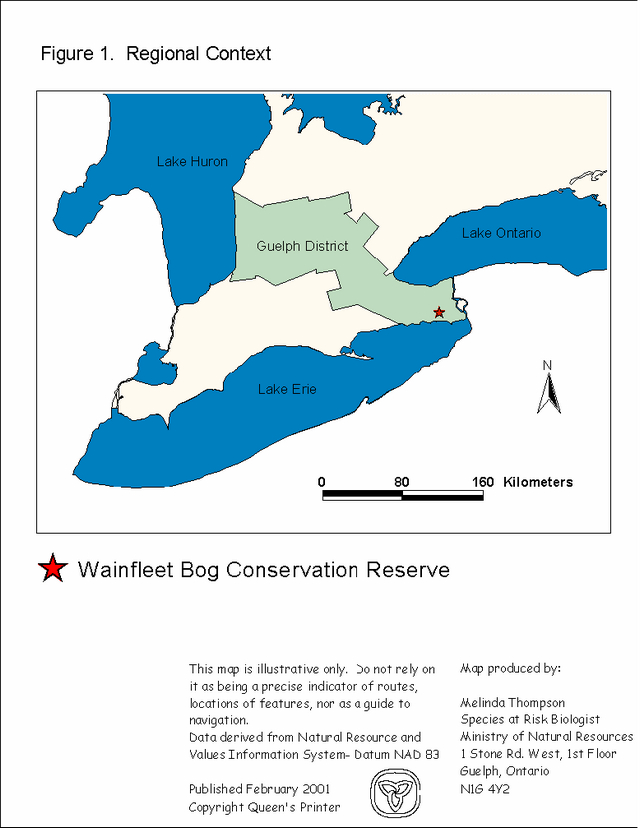
Enlarge figure 1. Regional Context
Figure 2: Wainfleet Bog
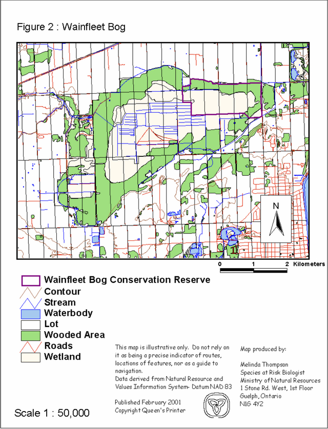
Enlarge figure 2: Wainfleet Bog
2.2 Life science:
The reserve is located within ecological Site District 7E-5. The assessment of life science values is primarily focussed on landform type and the vegetation communities that occur on those landforms within the context of a site district. The reserve is dominated by peat/wetland formations with a minor intrusion of successional communities along the boundaries.
Life science significance is determined on the basis of the following criteria: representation, diversity, condition, ecological considerations and special features (Crins, 1998).
Representation:
The vegetation of the reserve and its immediate vicinity includes several peatland bog communities and associated wetland communities at various semi-disturbed and successional stages. In the vicinity are successional and anthropogenic communities associated with current and past agriculture and peat moss extraction. The reserve occurs in the northeastern portion of the extensive Wainfleet Marsh basin. It generally presents a large central bog on the north: the east is a fringe zone with clay plain swamps, thicket swamps and marshes, and to the south and west are drained and mined peatlands with their highly successional thicket and forest communities (Macdonald, 1992). These are described generally below.
Wetland / peatland communities
- Open Low Shrub Bog
- Open Low Shrub Bog - Hummock Phase
- Open Tall Shrub Bog
- Deciduous Swamp / Thicket Swamp (successional) Treed Bog / Deciduous Swamp Fringe
- Deciduous Swamp (successional)
Clay plain communities
- Deciduous Swamp Fringe
- Deciduous Swamp (successional) Thicket Swamp (successional) Thicket Swamp
- Marsh Meadow - Forb Phase
- Thicket Swamp Slough (remnant)
- Marsh Meadow - Low Graminoid Phase Marsh Meadow - Tall Graminoid Phase Emergent Meadow - Seasonal Pond Phase
Successional communities
- Old Field - Meadow Phase
- Old Field - Thicket Phase
- Deciduous Forest
- Dugout Pond / Ditch Channel Peat Extraction Trench Barrens Berm / Peat Mound
- Roadway Barrens
Figure 3. Wainfleet Bog Conservation Reserve
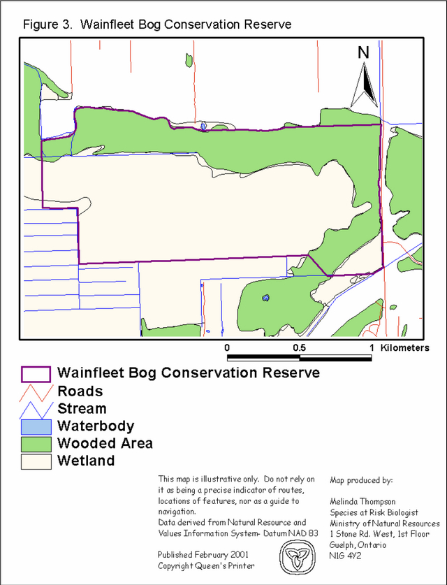
Enlarge figure 3. Wainfleet Bog Conservation Reserve
Condition:
The Wainfleet bog has well-developed peatlands and plant communities that provide bog habitat conditions for wild life. As the largest bog in southwestern Ontario, this extensive peatland is one of the most significant and intact natural features still existing in the Niagara Peninsula.
The Wainfleet Marsh basin has undergone considerable disturbances over the past century. Although these disturbances have not occurred directly within the boundaries of the Conservation Reserve, their influence may have had some impact. The extensive system of drainage ditches caused by peat extraction on the adjacent portions of the bog appears to have lowered the water table over the past half century. The result of this activity has drastically altered the former low shrub bog communities on the adjacent lands contributing to the invasion of trembling aspen (Populus tremuloides) and non- native European birch (Betula pendula ). It is not clear if the succession of European Birch in the Conservation Reserve is a result of lowered water tables in the adjacent lands or is occurring naturally.
Fires have occurred periodically within the basin due to the overall drying of the peatland. Charcoal presence in peat composition studies indicates that there have been periodical impacts caused by fires in the bog over the last 350 years (Nagy, 1992). The most recent fire in the spring of 1999 resulted in the partial destruction of approximately 50 acres of peatland (Yagi, 1999). Fire will continue to be a threat to the natural features of the bog unless measures are taken to reduce the overall dryness of the peat.
Diversity:
The Wainfleet Marsh supports a relatively low diversity of vegetation communities, yet the regional rarity of a distinctive peatland complex provides a high potential for supporting a rich and interesting flora, which includes bog species having northern, southern, mid-western and eastern affinities. The total flora of the Wainfleet Marsh basin currently contains 475 taxa, including species, subspecies, varieties, forms and hybrids. Within the boundaries of the reserve, 289 taxa have been identified (Macdonald, 1992). The floristic richness of the area may be accounted for by the geographic situation of the area, the general prevalence of disturbance and associated creation of successional habitats, and the century-long history of interest in the natural features that has resulted in an intensive level of inventory.
Ecological considerations:
The most significant area of the Wainfleet Bog is that portion which is designated as the Conservation Reserve. This section is the most undisturbed portion of the bog, although the hydrology and the disturbed nature of the adjacent sections of the bog are affecting the quality and diversity of natural features within the conservation reserve.
Special features:
An array of species has been identified with varying importance at the regional (R), provincial (P) and national (N) level. Some species have been classified as Vulnerable, Threatened or Endangered (VTE) in Ontario.
Flora - 283 species (467 species within Wainfleet Basin)
|
Provincially significant |
S Rank |
|---|---|
|
Carex albicans var. emmonsii (Emmons' Sedge) |
S1 |
|
Carex swannii (Swan’s sedge) |
S3 |
|
Carex jamesii (Nebraska Sedge) |
S3 |
|
Bartonia virginica (Yellow Screwstem) |
S2 |
|
Bidens coronata (Southern Tickseed ) |
S2 |
|
Juncus acuminatus (Sharp-fruit Rush) |
S3 |
|
Linaria canadensis (Toadflax) |
S1 |
|
Linum virginianum (Virginia yellow flax) |
S2 |
|
Ludwigia polycarpa (Many-fruited False Loosestrife) |
S2 |
|
Torreyochloa pallida (Torrey’s Manna Grass) |
S2 |
|
Quercus palustris (Pin Oak) |
S3 |
Regionally significant (Macdonald, 1992)
Arabis drummondii (Drummond’s Rock-cress)
Aralia hispida (Bristly Sarsaparilla)
Betula pumila (Grey Birch)
Carex cumulata (Piled-up Sedge)
Carex gynandra (Northern Fringed Sedge)
Kalmia angustifolia (Sheep-laurel)
Ledum groenlandicus (Labrador tea)
Moehringia lateriflora (Grove Sandwort)
Rubus setosus (Bristly Raspberry)
Sarracenia purpurea (Pitcher Plant)
Viburnum recognitum (Southern Arrowwood)
Viola lanceolata (Lance-leaved Violet)
Woodwardia virginica (Virginia Chain Fern)
Fauna -
(at least 90 bird species (52 recently occurring, 30 breeding), 20 mammal species, 21 reptile/amphibian species)
|
Provincially Significant |
S Rank |
COSEWIC |
|---|---|---|
|
Clemmys guttata (Spotted Turtle) |
S3 |
THR |
|
Elaphe obsoleta obsoleta (Black Rat Snake) |
S3 |
THR |
|
Icteria virens (Yellow-breasted Chat) |
S2/S3 |
SC |
|
Isobrychus exilis (Least Bittern) |
S3 |
SC |
|
Sistrurus catenatus catenatus (Eastern Massassauga Rattlesnake) |
S3 |
THR |
|
Vireo griseus (White-eyed Vireo) |
S2B, SZN |
|
|
Asio flammeus (Short-eared Owl) |
S3S4 |
SC |
|
Parus bicolor (Tufted Titmouse) |
S2S3 |
|
|
Ambystoma jeffersonianum (Jefferson salamander) *not yet confirmed by electrophoretic analysis |
S2 |
THR |
Regionally significant wetland birds
Aythra americana (Redhead)
Thryothorus ludovicianus (Carolina wren)
Regionally significant
Castor canadensis (Beaver)
Erethizon dorsatum (Porcupine)
Incisalia augustinus (Brown Elfin Butterfly)
Lycaena epixanthe (Bog Copper Butterfly)
Lycaena phleas americana (American Copper Butterfly)
Lycaena hyllus (Bronze Copper Butterfly)
Melospiza lincolnii (Lincoln’s Sparrow)
Other: The Wainfleet Bog is the most extensive peatland in southwestern Ontario. This area represents a series of well-developed, species rich peatland communities that contain elements not reported elsewhere in southern Ontario.
In summary, although the landscape is already well represented within the natural heritage system (there are many remaining bogs in central and northern Ontario), the strategic location and special features and species make this area provincially significant within the natural heritage areas system.
Care will have to be taken to ensure that the uses that currently occur and/or may be considered in future do not affect the natural values of the reserve (see 3.0 Management Guidelines).
2.3 Recreational/aesthetic values:
The site lends itself well to educational and recreational opportunities. Integrated within a site trail system, many of the natural features could provide educational opportunities related to bog ecosystems and anthropogenic influences. The area accommodates many recreational activities, including seasonal hunting for deer, upland game and waterfowl. Naturalists and other visitors enter the bog over a wide variety of seasons to observe, record and enjoy the natural biota. Activities such as hiking, birdwatching, photography, scientific research, archery and shotgun hunting, horseback riding, snowmobiling, all terrain vehicle and motorbike riding have historically occurred in this area, although motorized vehicles are no longer permitted.
All these recreational uses are dependent on the area’s natural, undeveloped state, and rare habitats/species being protected and still being accessible to residents and visitors.
3.0 Management guidelines
3.1 Land tenure
Background:
Wainfleet Bog Conservation Reserve consists entirely of crown lands within the Township of Wainfleet and the City of Port Colborne. This 230 ha area encompasses the northeastern corner of the Wainfleet Marsh basin. To the south, approximately 801 hectares of the bog are managed by the Niagara Peninsula Conservation Authority. Another parcel of the bog 81 hectares in size is owned by the Nature Conservancy of Canada (located to the west of the Conservation Reserve).
The Conservation Reserve is bordered at the east by Hwy 58, to the south by the NPCA property and to the west by the NCC property. Much of the bog is designated as "hazard" by the township. The area selected for the conservation reserve is designated as environmental protection/open space (Frohlich, 1997). Most of the surrounding area is zoned as agricultural, special agricultural or urban residential. To the east of the conservation reserve is area designated as municipal landfill. Although these designations may seem conflicting, the entire bog is designated as an environmentally sensitive area within the Regional Municipality of Niagara’s Policy Plan (Frohlich, 1997).
Unregistered rights in the property include Consumers Gas, Biederman Drain and Ontario Hydro (Frohlich, 1997).
Guideline:
The permitted existing and proposed adjacent land uses are not directly compatible with the general planning direction of long term protection for the Wainfleet Bog. Future developments proposals, amendments and existing practices should recognize this and ensure that compatible land uses are encouraged in the future.
3.2 Development
Background:
There is no development within the Conservation Reserve. An overgrown road allowance is found at the north end which soon branches out into a network of faint trails that eventually disappear into the heath vegetation.
Guideline:
There are no structures permitted in Wainfleet Bog. All proposals for new development must meet the requirements of Procedural Guideline B - Land Uses - Test of Compatibility (Appendix 1).
3.3 Recreational activities
Background:
The area accommodates many recreational activities, including seasonal hunting for deer, upland game and waterfowl. Naturalists and other visitors enter the bog over a wide variety of seasons to observe, record and enjoy the natural biota. Activities such as hiking, birdwatching, photography, scientific research, archery and shotgun hunting, horseback riding, snowmobiling, all terrain vehicle and motorbike riding have historically occurred in this area. Motorized vehicles are no longer permitted in the area.
Guideline:
The current range of recreational activities will be permitted and new activities will be considered on a case by case basis provided they are consistent with maintaining the natural values of the reserve and comply with Procedural Guideline B (Appendix 1).
Emphasis will be placed on activities that have a low impact on the environment of the reserve.
3.4 Commercial activities
Background:
Adjacent areas of the bog have been mined commercially for peat. Peat extraction began as early as the 1890's (Frohlich, 1997), and approximately half of the entire bog has been strip mined (Terpstra, 1983).
Guideline:
Exploitation of the site for commercial peat extraction and/or urban development are not economically feasible or practical at this time, and would also adversely affect the goal of ecosystem restoration (Frohlich, 1997).
Conservation reserves do not permit mining, commercial forest harvesting, hydroelectric power development, the extraction of aggregate and peat or other industrial uses (Public Lands Act, Ontario Regulation 805/94). Other new commercial activities must meet the requirements of Procedural Guideline B (Appendix 1).
3.5 Aboriginal interests
Background:
There are no known aboriginal interests.
Guideline:
Government policy will guide dealings with aboriginal interests.
3.6 Natural resource stewardship
3.6.1 General
Background:
Most of the uses that have traditionally been enjoyed in the Wainfleet Bog will be allowed to continue. Vegetation management for specific purposes is not known to have occurred in the past and logging activity has been minimal. Wildlife and fisheries management, particularly hunting, has been occurring according to the prevailing policies and legislation at the time.
Guideline:
The conservation reserve will be managed by allowing natural ecosystems and processes to function as they would with minimal human interference. Natural values that require particular consideration before any future uses can be approved include vegetation and wildlife (particularly rare species) and fisheries habitat.
3.6.2 Vegetation
Background:
Some vegetation community associations may require restoration to return them to their original state. Restoration of saturated conditions, anaerobic activity, acidic and low nutrient conditions in the adjacent parts of the bog may be required to re-establish sphagnum growth and peat development processes (Frohlich, 1997). Elimination of the non-native and invasive European birch and trembling aspen may not be controlled directly by changes to current site conditions. Ultimately management of this invasive exotic would require hand removal or burning. However before this is undertaken on a large scale it still needs to be determined what role this species is playing for providing habitat for eastern massassauga rattlesnake, mammals and birds. In addition it needs to be determined if the re-establishment of tamarack and black spruce in the bog proper is feasible.
Guideline:
Any restoration or management policies will be implemented through existing partnerships with adjacent landowners. Ongoing efforts to restore the bog to its natural condition should continue, with the recognition that complete rehabilitation will be an extremely lengthy process.
3.6.3 Wildlife
Background:
The reserve is part of a controlled deer hunt (Wildlife Management Unit 89A) area. Potential special concerns related to wildlife in this reserve include over-harvesting of species for human consumption (leopard frogs) and for the pet trade (spotted turtles), and persecution of snakes due to negative attitudes (eastern massasauga rattlesnakes).
Guideline:
Clear guidelines are in place for the controlled deer hunt with strict tag limits to control hunter numbers. Current enforcement and monitoring in Wainfleet Bog will continue.
In the past Over winter estimates averaged 350 (1990 survey) deer in the bog. Present numbers are estimated to be 125 (2000 survey). Therefore the CDH has been successful at managing deer populations in the bog.
The restoration goal is to manage for obligate bog species over time. This can be accomplished by providing for critical habitats within the protection of the bog; i.e building gestation piles adjacent to hibernation sites for EMR's may provide a higher survivability and recruitment of neonates into the population. Presently gestation sites outside the ANSI are being used. Future research may help us determine why.
Many of the faunal species located in the bog are protected under the Fish and Wildlife Conservation Act. It is illegal to collect or harm a species that is specially protected under the Act. This Act will continue to be enforced in order to ensure the protection of these species.
Some of the bog’s animals and plants are obligate bog species, meaning that they can only survive in a bog. Habitat restoration activities targeting these species should be undertaken at every opportunity.
3.7 Cultural resource stewardship
No values have been identified to date. Partners will be encouraged to undertake studies to further document these values.
3.8 Client services
Background:
There are no existing client services specific to Wainfleet Bog.
Guideline:
The focus will be on low key information and self- interpretation of area values and features. If possible, an effort to coordinate visual identity amongst all the partners will occur. Priority will be placed on an information brochure that highlights reserve values and their role in the provincial and regional (Niagara) natural heritage areas system. This would include relationships with Wainfleet Bog Conservation Area (NPCA) and Wainfleet Bog natural area (NCC) and natural areas within site district 7E-5 (e.g. St John’s – Fonthill Sandhill Valleys, Rock Point Provincial Park, Niagara Glen etc.).
Information should also speak to appropriate uses to ensure the protection of those values.
The ministry will seek interested partners to prepare this brochure. Additionally, 'CR' identity signs may be considered around the periphery of the reserve to provide better recognition for the area.
3.9 Research
Background: Research to date has consisted of inventories of the natural values of the reserve. The Ministry of Natural Resources has completed life science inventories and further research has been undertaken by the University of Waterloo and by private consultants on featured species such as massasauga rattlesnake and spotted turtle. The MNR is also conducting studies on the habitat requirements of these reptiles. The goal of the MNR research is to determine critical habitat, habitat use and population statistics. There is a still a need to monitor the impact of use on natural values and to identify cultural and aboriginal values within the reserve.
Guideline:
The ministry will encourage further inventory and documentation of natural and cultural values, and the assessment of use/activity impacts. All research will be carried out in a non-destructive manner. Research proposals must follow Procedural Guideline C – Research Activities in Conservation Reserves (Appendix 2).
3.10 Marketing
Background: There has been no direct marketing to date. All promotion has been by word of mouth, through local and southern Ontario media stories and various information sheets available from the Ministry of Natural Resources, the Niagara Peninsula Conservation Authority, Brock University and local conservation groups.
Guideline:
The future should see a shift to providing information on the place of the reserve within a system of natural areas in Niagara Region and beyond. Aggressive marketing activities are not appropriate.
4.0 Implementation
Administrative responsibility for this Conservation Reserve is located with the Niagara Area Office of Guelph District Ministry of Natural Resources. The Area Office will continue with the custodial care of the Reserve and will also seek partnerships with local interests, wherever appropriate. The Area Office will also continue to support and advocate the 'Friends of Wainfleet Bog'.
Initial emphasis will be placed on awareness information and the highlighting of appropriate uses. This may be undertaken with the assistance of local groups.
Priorities will include:
- Prepare a brochure and map on the reserve for public information and awareness.
- Coordinate site signs and the placing of 'CR' reference signs around the periphery of the reserve and along the two public roads
- Encourage further inventory of the cultural history and resources of the reserve. Undertake a study to determine use levels and impacts.
- Undertake further studies to determine changes in water levels of the bog and monitor changes caused by blockage of drainage channels.
- Continue to work with the Niagara Peninsula Conservation Authority, the Metro Toronto Zoo and local conservation groups on population monitoring and recovery of the Eastern Massassauga Rattlesnake within the bog.
5.0 Review and Revision of the Statement of Conservation Interest
Statements of Conservation Interest will be amended through a standard process of minor and major amendments. Minor amendments will be processed in a relatively informal manner and will require the approval of the Area Supervisor. These amendments will deal with uses and activities that do not affect any of the policies in this SCI (e.g. new uses and/or activities that are consistent with existing use impacts).
Uses and/or activities that were not anticipated in the approved SCI and which may have an impact on the values of the Reserve (e.g. a road or a building) will require a major amendment. This will include an opportunity for public comment and input, will require the approval of the Regional Director and public posting on the MOE Environmental Registry.
References
COSEWIC. 2000. Canadian Species at Risk. November 2000. Committee on the Status of Endangered Wildlife in Canada. vi + 26 pp.
Crins, W. J. and P. S. G. Kor. 1999. Natural Heritage Gap Analysis Methodologies Use by the Ontario Ministry of Natural Resources. Unpublished Paper. Peterborough: OMNR.
Frohlich, K. 1997. Wainfleet Bog Management Plan. Niagara Peninsula Conservation Authority, Allanburg, Ont. 89 pp.
Hills, G.A. 1959. A ready reference to the description of the land of Ontario and its productivity. Ont. Dept. of Lands and Forests, Division of Research, Maple, Ontario.
Jonsson-Minniss, S. and J. Middleton. 1992. Effect of peat extraction on the vegetation in Wainfleet Bog, Ontario. Canadian Field-Naturalist 105(4): 505-511.
Kaiser, J. 1986. Updates of Life Science Inventory Checksheet of Wainfleet Peat Basin Heath ANSI. OMNR, Parks and Recreation Section, Central Region, Niagara District. OFER 8610. i + 11 pp. + maps.
Lee, H.T., W.D. Bakowsky, J. Riley, J. Bowles, M. Puddister, P. Uhlig and S. McMurray. 1998. Ecological Land Classification for Southern Ontario: First Approximation and its Application. Ontario Ministry of Natural Resources, Southcentral Science Section, Science Development and Transfer Branch. SCSS Field Guide FG-02.
Macdonald, I.D. 1980. Life Science Features of the Haldimand Clay Plain Physiographic Region, OMNR, Cental Region, Richmond Hill. SR OFER 8001. Vii + 131 pp. + maps.
Macdonald, I.D. 1992. A Biological Inventory and Evaluation of the Wainfleet Bog ANSI. OMNR, Parks and Recreation Areas Section, Southern Region, Aurora. OFER 9205. vii + 154 pp.
Nagy, B.R. 1992. Postglacial Paleoecology and Historical Disturbance of Wainfleet Bog, Niagara Peninsula, Ontario. M.A. thesis. University of Waterloo, Waterloo, Ont. 129 pp.
Oldham, M.J. 1999. Natural Heritage Resources of Ontario: Rare Vascular Plants (3rd ed.). Natural Heritage Information Centre, Ontario Ministry of Natural Resources, Peterborough, Ontario. 56 pp.
Ontario Ministry of Natural Resources. 2000. Index List of Vulnerable, Threatened, Extirpated or Extinct Species of Ontario. OMNR , Ontario Parks, Peterborough. 26 pp.
Plourde, S.A., E.L. Szepesi, J.L. Riley, M.J. Oldham, and C.A. Campbell. 1989.
Distribution and Status of the Herpetofauna of Central Region, Ontario Ministry of Natural Resources. Ontario Ministry of Natural Resources, Parks and Recreational Areas Section, Central Region, Richmond Hill. 30 pp.
Riley, J.L., J.V. Jalava, M.J. Oldham and H.G. Godschalk. 1997. Natural Heritage Resources of Ontario: Bibliography of Life Science Areas of Natural and Scientific Interest in Ecological Site Region 6E and 7E, Southern Ontario. First Edition. Ontario Ministry of Natural Resources, Natural Heritage Information Centre, Peterborough. 156 pp. + 3 maps.
Terpstra, P. 1983. Summary of Ownership, Ministry Program Interests, Planning Status and Management Strategies in the Wainfleet Peat Basin Heath Natural Area. Ontario Ministry of Natural Resources, Parks and Recreation Section, Central Region, Richmond Hill. 10 pp.
Yagi, A. and K. Frohlich. 1999. Wainfleet Bog Restoration: Challenges and Future Direction. (An interim report) OMNR, Vineland, Ont., and Niagara Peninsula Conservation Authority, Welland, Ont. 12 pp.
Appendix 1 procedural guideline B – land uses – test of compatibility (PL procedure 3.03.05)
The Conservation Reserve policy provides broad direction with regard to the permitted uses. The policy provides only an indication of the variety of uses that will be considered acceptable in conservation reserves. The only caution is that "any new uses, and commercial activities associated with them, will be considered on a case by case basis, and, they must pass a test of compatibility to be acceptable." What does a 'test of compatibility' mean?
An examination of this must start from the premise of why an area is set aside – specifically, its representative natural heritage values. Criteria are then identified to guide compatibility considerations. These criteria apply to the long-term acceptability of both existing uses and new uses.
-
Conformity to SCI/RMP: SCI describe values for which an area has been set aside and the range of appropriate uses that will be permitted in the area. SCI may also speak to the acceptability of other 'new' uses currently not occurring in the area.
The first 'test' is: "do proposed new land uses and/or commercial activities conform to the direction of the SCI/RMP for the conservation reserve? Would the new use(s) depart from the spirit of appropriate indicator land uses in the SCI/RMP?"
- Impact Assessment: If the proposed use(s) pass test 1 it is important to determine their impact on the area before they are approved. This should include the following:
- Impact on natural heritage values: "will the new use(s) impact any natural values in the area? If so how and to what degree? Is it tolerable?"
- Impact on cultural values: "will the new use(s) impact an historical or archaeological values in the area?" Impact on research activities: "will the new use(s) affect research activities in the area?"
- Impact on current uses: "will the new use(s) have any negative impact on the array of current uses?"
- Impact on area administration: "will the new use(s) increase administrative costs and/or complexity?" (For example, the cost of area monitoring, security and enforcement).
- Impact on accommodating the use outside the conservation reserve: "Could the use(s) be accommodated as well or better outside the conservation reserve?"
- Impact on socio-economics of the area: "will the new use(s) affect the community(ies) surrounding the area in a positive or negative way?" (For example, will the new use make an are a less remote thereby affecting a local tourism industry that is dependent on the area’s remoteness for its appeal?"
- Impact on area accessibility: "does the new use(s) give someone exclusive rights to the area or a portion of the area to the exclusion of other existing uses?"
The following table provides a guide of indicator uses for the consideration of uses that may be permitted within conservation reserves. For any specific conservation reserve that test of compatibility should be applied to determine which specific uses are acceptable.
Indicator uses for conservation reserves - generic and specific
Recreation
| Activities | Generic Policy Permitted? Existing | Generic Policy Permitted? New | Specific Application In Wainfleet Bog |
|---|---|---|---|
| Sport fishing | Yes | Yes | Yes |
| Sport hunting | Yes | Yes | Yes |
| Food gathering | Yes | Yes | Yes |
| Facility infrastructure | Maybe | Maybe | No |
| Non-trail snowmobiling | Maybe1 | Maybe1 | No |
| Non-trail ATV use | Maybe1 | Maybe1 | No |
| Rock climbing/caving | Maybe | Maybe | No |
| Canoeing/kayaking | Yes | Yes | No |
| Motorized boating | Yes | Yes | No |
| Picnicking | Yes | Yes | Yes |
| Camping | Yes | Yes | No |
| Trails: Hiking | Yes | Maybe | Yes |
| Trails: X country skiing | Yes | Maybe | Yes |
| Trails: Cycling | Yes | Maybe | No |
| Trails: Horse riding | Yes | Maybe | No |
| Trails: Snowmobiling | Yes | Maybe | No |
Science, education & heritage appreciation
| Activities | Generic Policy Permitted? Existing | Generic Policy Permitted? New | Specific Application In Wainfleet Bog |
|---|---|---|---|
| Research | Yes | Yes | Yes |
| General walking | Yes | Yes | Yes |
| Photography & Painting | Yes | Yes | Yes |
| Wildlife viewing | Yes | Yes | Yes |
| Outdoor Education/Interpretation | Yes | Yes | Yes |
| Collecting | No | No | No |
Commercial activities
| Activities | Generic Policy Permitted? Existing | Generic Policy Permitted? New | Specific Application In Wainfleet Bog |
|---|---|---|---|
| Food harvesting | Maybe | Maybe | No |
| Fishing | Maybe | Maybe | No |
| Baitfish harvesting | Yes2 | Maybe | No |
| Trapping | Yes2 | Maybe | No |
| Trap cabins | Yes | No | No |
| Resort – outpost camp | Yes2 | No | No |
| Outfitting – bear management | Yes2 | No | No |
| Wild rice harvesting | Yes | Maybe | No |
Resource management
| Activities | Generic Policy Permitted? Existing | Generic Policy Permitted? New | Specific Application In Wainfleet Bog |
|---|---|---|---|
| Inventory monitoring | Yes | Yes | Yes |
| Featured species management | Maybe | Maybe | Yes |
| Natural systems management | Maybe | Maybe | Yes |
Industrial activities
| Activities | Generic Policy Permitted? Existing | Generic Policy Permitted? New | Specific Application In Wainfleet Bog |
|---|---|---|---|
| Timber harvesting | No | No | No |
| Prospecting | No | No | No |
| Mining | No | No | No |
| Hydro generation | No | No | No |
| Energy transmission corridors | Yes | No | No |
| Communications corridors | Yes | No | No |
| Transport corridors | Yes | No | No |
| Resource roads (MNR) | Yes | No | No |
Other activities
| Activities | Generic Policy Permitted? Existing | Generic Policy Permitted? New | Specific Application In Wainfleet Bog |
|---|---|---|---|
| Land Disposition | * | No | No |
| Hunt Camps | Yes2 | No | No |
Notes:
On generic policy application in conservation reserves:
1For retrieval of game only.
2Transfer requests will be considered in the context of the Statement of Conservation Interest or Resource Management Plan for each conservation reserve.
*Existing dispositions will continue, however, as opportunities arise the Ministry will acquire and/or remove them outside the CR.
Appendix 2 procedural guideline C – Research activities in conservation reserves (PL Procedure 3.03.05)
Purpose
To encourage contributions to the goal of conservation reserves by:
- Providing direction for research activities associated with conservation reserves; and
- Establishing a process for the review and approval of proposals by researchers, which could have an impact on the values protected by the conservation reserve.
Definition
Research means any investigation or study of the natural, cultural, economic, management or other features or characteristics of conservation reserves.
Guidelines
Research will be encouraged to provide a better understanding of the natural values protected by a conservation reserve and to advance their protection, planning and management. The Statement of Conservation Interest will define, for each conservation reserve, the key research issues, set out the parameters within which research may occur and identify research needs.
Applications and approvals
Researchers must apply in writing to the Area Supervisor for permission to conduct research. The request letter must contain a statement explaining why the proposed research should be undertaken in the particular conservation reserve in preference to another location.
Proposals will be reviewed and approved by the Area Supervisor, guided by the SCI prepared for each reserve (see Guideline A – Resource Management Planning) and using Guideline B – Land Uses – Test of Compatibility. Permission must be granted in writing, including any conditions to be met in conducting the research, prior to the undertaking of any research project.
Term and conditions
Permission to conduct research under this policy will be valid for a period of 12 consecutive months from the date of issue. Permission to continue a research project for additional periods of 12 months or less may be granted upon submission of a written request and a progress report. The Ministry may require the posting of collateral to assure that the terms and conditions of granting permission are met.
The Area Supervisor may suspend or revoke permission at any time for failure on the part of the researcher to meet:
- The intent of this policy.
- The requirements under the Public Lands Act, including all amendments, where applicable.
- The requirements under any other Act or regulations of Ontario or Canada, including those governing the taking, handling, storing, confining, trapping, excavating and marketing any specimen, artifact, information or action (for example, scientific collector’s permit).
- The conditions and agreements specified in granting permission.
Final report
The researcher will submit copies of reports, publications and theses following the results of the project to the Area Supervisor.