Western Lake Superior Conservation Reserve Management Statement
This document provides policy direction for the protection, development and management of the Western Lake Superior Conservation Reserve and its resources.
Statement of Conservation Interest (C2260)
May 2004
Thunder Bay District
Ministry of Natural Resources
Approval statement
We are pleased to approve this Statement of Conservation Interest for the Western Lake Superior Conservation Reserve.
This Statement of Conservation Interest provides guidance for the management of the Conservation Reserve and the basis for the ongoing monitoring activities. More detailed direction at tlus time is not anticipated. Should significant issues arise requiring additional studies and more defined management direction, a more detailed Conservation Reserve Management Plan will be prepared with full public consultation.
The public was widely consulted during the original regulation process of the Conservation Reserves boundary and further consultation is not required at this time.
The Conservation Reserve will be managed under the jurisdiction of the Lakehead Area Supervisor, Thunder Bay District, Ministry of Natural Resources.
Signed by:
W.D. Baker
District Manager
Thunder Bay District
Ministry of Natural Resources
Date: June 01, 2004
Signed by:
Charlie Lauer
Regional Director
Northwest Region
Ministry of Natural Resources
Date: June 04, 2004
Background information
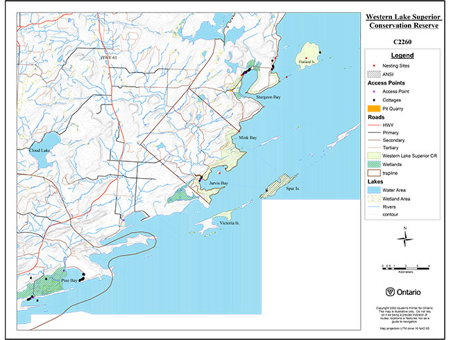
The Western Lake Superior Conservation Reserve is composed of a complex of islands and shoreline parcels extending along the shoreline of Lake Superior. It is located just southwest of Thunder Bay. The three distinct mainland parcels are located along the shoreline adjacent Sturgeon Bay, Pine Bay and Jarvis Bay. Three larger islands included in the Conservation Reserve are Flatland, Spar and the eastern half of Victoria Island. There are also a number of smaller islands included.
This Conservation Reserve is part of the Great Lakes Heritage Coast signature site. Spar Island was previously identified as an Area of Natural and Scientific Interest (ANSI). Provincially significant wetlands are located at Pine Bay and Sturgeon Bay. The Western Lake Superior Conservation Reserve is comprised of rugged terrain, a diversity of forest types, as well as significant wetland vegetation types, making it an exceptional area for a multitude of recreational uses. Boating, hiking and fishing are among the many uses in the area.
The intent of this Statement of Conservation Interest is to identify the natural heritage values, the activities occurring within the site, outline the activities permitted or prohibited and to provide a clear direction on management for the Western Lake Superior Conservation Reserve.
| Name | Western Lake Superior Conservation Reserve |
|---|---|
| Site Region/Site District | 4W-2 |
| OMNR Administrative Region/ District/Area | Northwest Region, Thunder Bay District, Lakehead Area |
| Total Area (ha) | 1,572 ha |
| Regulation Date | Pending settlement of the Fort William First Nation land claim. |
| First Nations Interest in Area | Fort William First Nation |
| OBM | 163005320, 163205320, 163205340, 163305340, 163105320, 163205330, 163305330, 163405330 |
| Latitude/Longitude | 48°08' / 89°20' |
| NTS 1:50 000 Map | Jarvis Bay 52A3, Pigeon River 52A4 |
| Last FRI Completed | 1992 |
| General Location Description | 30 kms south of the City of Thunder Bay along the western shore of Lake Superior. |
| Access | The Conservation Reserve can be accessed by road to the Sturgeon Bay parcel. The Jarvis Bay parcel and the Pine Bay parcel are accessed using trails or abandoned timber access roads. The islands are boat accessible. |
1.1 Representation targets
This section provides a summary of the earth and life science values, cultural resources represented and recreational opportunities available or possible within the Western Lake Superior Conservation Reserve.
| Earth Science Representation: | The landform types identified during the Reconnaissance Inventory are:
|
|---|---|
| Life Science Representation: | The Landform/Vegetation Types identified within the area during the Reconnaissance Inventory are:
|
| Cultural Resource Representation: | Over ten archeological or historic sites are documented. Most of these sites are in the Sturgeon Bay parcel and the Jarvis Bay parcel. |
| Recreational Opportunities: | Canoeing, kayaking and boating enthusiasts utilize the shoreline and islands. The area has moderate to moderately high capability for outdoor recreation. Fishing opportunities exist in many sections of the Conservation Reserve. Cliffs, islands, lake vistas and steep topography allow for viewing and photography. Trails on the mainland and on Spar island provide opportunities for wildlife viewing and nature appreciation. |
1.2 Survey information
This section provides an overview of the inventories completed, their level of detail and any further inventories that are necessary.
| Survey Level | Reconnaissance | Detailed |
|---|---|---|
| Life Science | Checklist and Summary report, Geowest Environmental Consultants Ltd. 2000. | Not required |
| Earth Science | Checklist and Summary report, Geowest Environmental Consultants Ltd. 2000. | Not required |
| Recreational | Checksheets and Summary report 2000 | Not required |
| Cultural | Not required at this time. | Not required |
2.0 Values to be Protected
This section provides the key natural heritage values on the site, their condition relative to past resource use and management activities, as well as their sensitivity to future land use and management activities.
| Cultural | A number of cultural and historic sites are present. |
|---|---|
| Aboriginal | No aboriginal values have been identified at this time. |
| Tourism | There are some hiking trails within the site. A resort exists adjacent to the Sturgeon Bay parcel at Mink Bay. |
| Recreational Fishing | The waters of Lake Superior provide excellent recreational fishing. |
| Recreational Hunting | This site is within two Bear Management Areas. There are also opportunities for hunting a variety of game species. |
| Mining | Private mining rights are currently subject to forfeiture. The Crown owns the surface rights. |
| Aggregate | None exist within Conservation Reserve boundaries. |
| Forest Harvest | Forest harvesting is not permitted within Conservation Reserve boundaries. |
| Wild Rice | None observed on site. |
| Trapping | Site is part of two traplines, TB71, TB75. |
| Wildlife | Suitable habitat conditions exist for a variety of species such as moose, deer, bear, fur bearers and a number of bird species. |
| Commercial Fisheries | Portions of the Conservation Reserve are within two baitfish blocks. |
2.1 Life sciences
Western Lake Superior Conservation Reserve was selected for protection under Ontario’s Living Legacy partially due to a number of significant features. Spar Island has been previously identified as an Area of Natural and Scientific Interest (ANSI) and wetlands adjacent Pine Bay and Sturgeon Bay are provincially significant. There is a diversity of upland forest and wetland vegetation in the area. The Sturgeon Bay and Jarvis Bay parcels include various forest communities. Theseinclude , deciduous-dominated mixedwood, coniferous- dominated and pure deciduous stands.
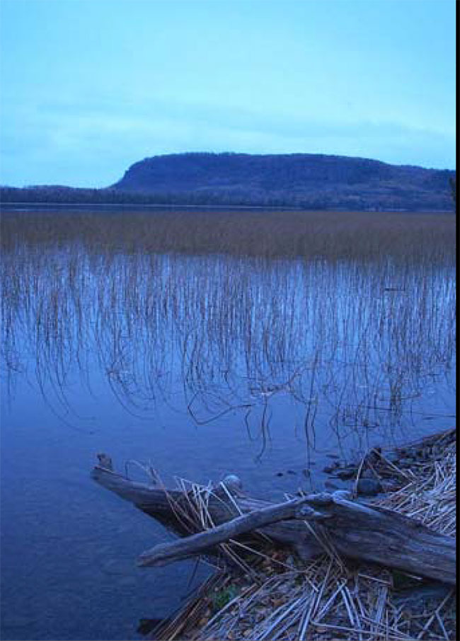
Figure 1: Southeast end of Sturgeon Bay
The deciduous stands are generally made up of trembling aspen or white birch. Patches of balsam fir-dominated coniferous mixedwood also occur on cooler aspects. Black spruce dominated stands with occasional balsam fir, tamarack and white birch occur on depressional sites that have thin to moderately thick organic deposits. Marshes and thicket swamps occur occasionally along the lake margins in Sturgeon and Jarvis Bays.
The Pine Bay parcel is comprised of wetland vegetation communities including poor conifer swamp and poor fen types. (Geowest Environmental Consultants Ltd. 2000b).
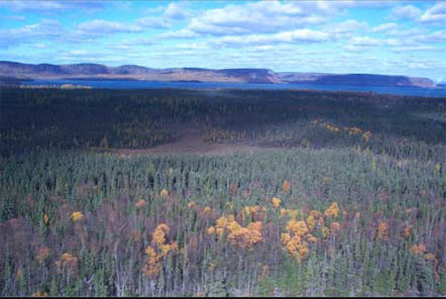
Most of the central portion of Flatland Island is dominated by dense black spruce forest with occasional occurrences of balsam fir and tamarack. On the wettest sites in the interior of the island, there are occurrences of open fen vegetation communities. White birch dominated mixedwood stands occur extensively in the outer, drier portions of the island.
Figure 2 Flatland Island showing dense black spruce and occasional white birch forest.
Vegetation cover on both Spar and Victoria Islands is predominately deciduous-dominated mixedwood forest with small patches of coniferous forest. Noble (1980) also reported the occurrence of several arctic-alpine plants on Victoria Island.
2.2 Earth science
All of the parcels that make up this Conservation Reserve are very characteristic of the Animikie Basin.The area is comprised of a variety of landform types including till covered mesa and cuesta plateaus, bedrock escarpments, talus slopes, bare bedrock knolls, moderately to weakly broken morainal deposit, lacustrine deposits, beach deposits, and organic accumulations of variable thickness (Geowest Environmental Consultants Ltd. 2000a).
The Western Lake Superior Conservation Reserve is found in the Animikie Basin of the Southern Structural Province and was formed as part of the Midcontinent Rift (Ontario Geological Survey 1991a). This area is also referred to as the Port Arthur Homocline and is characterized by ridges and cuestas produced by the underlying folded sequence of Proterozoic (Logan) diabase sills and sedimentary rocks. Proterozoic sedimentary rocks of the Animikie Group Rove Formation consists of a lower part of black, locally pyritic shales which grades upward into shales interbedded with arkosic greywacke deposited by turbidity currents (Geul 1970). These rocks were deposited in a shallow-water, near-shore environment during a time of relative tectonic stability (Geowest Environmental Consultants Ltd. 2000a).
2.3 Cultural/historical significance
There are a number of archeological or historic sites in Western Lake Superior Conservation Reserve. Test pitting and archeological site investigation in Sturgeon Bay has revealed historic material, campsite locations, and cabin foundations from various time periods.
Prince Bay also has a number of archeological and historic sites including the Prince Bay Mine, which operated from 1846-1847. A trench and exploration pit can still be located on the site.
2.4 Aboriginal values
Specific aboriginal values within the Conservation Reserve have not been identified at this time.
2.5 Recreational values
Western Lake Superior Conservation Reserve provides opportunities for a variety of recreational activities. Water related activities such as boating and fishing have been observed . Shoreline and lakevistas providescenic viewing opportunities.
Lake Superior is used heavily by recreational boaters. Canoeing/kayaking enthusiasts utilize the shoreline and islands within the Conservation Reserve.
The Canadian Land Inventory- Land Capability for Outdoor Recreation has rated the lands within the Conservation Reserve as having moderate to moderately high capability for outdoor recreation. Recreational boaters have established and maintained three docking sites on the shorelines on Mink and Prince Bays and also at Spar Island. There are networks of trails associated with these sites.
There are fishing opportunities in sheltered bays along the Lake Superior shoreline and at the mouth of Jarvis River. Sports species present include northern pike, walleye, yellow perch, rainbow trout, brook trout, lake trout, lake herring, lake whitefish, smelt, and Chinook salmon.
Western Lake Superior Conservation Reserve is an exceptional site for photography and nature appreciation. The steep topography, diabase cliffs and talus slopes , offshore islands and viewpoints offer spectacular views of Lake Superior and the shoreline landscape.
There are two wetlands within or partially within the boundaries, Sturgeon Bay and Pine Bay. The Pine Bay parcel lies entirely within the Pine Bay wetland. The Sturgeon Bay wetland offers waterfowl and bird-watching opportunities.
3.0 Management guidelines
All management activities must conform with the intent and direction of this Statement of Conservation Interest. New activities which conform must also be assessed for their impacts and ensure the resource values which have been identified are not unduly impacted. Management projects within the conservation reserve activities are subject to the requirements of the Environmental Assessment Act.
3.1 Land tenure
Western Lake Superior Conservation Reserve consists entirely of Crown Land. Adjacent lands are to a large extent privately held. No disposition by sale, Crown Lease or Land Use Permit will be permitted within the Conservation Reserve.
3.2 Existing and proposed development
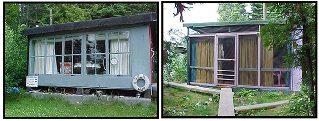
There is a history of boating and recreational use evidenced by structures on Flatland Island, Spar Island, Nisbet Bay, Prince Bay and Jarvis Bay. These structures include a sauna, dock and smaller building on Flatland Island. There arelarge buildings, saunas, docks and outhouses on Spar Island. These structures are unauthorized and will be identified and removed in accordance with Ministry policy.
Figure 3 Unauthorized Cabins on Spar Island.
There are docks at both Nisbit and Prince Bays and 2 abandoned cabins in Jarvis Bay. A more detailed investigation as to ownership of the cabins and their location with respect to the boundary of the conservation reserve is required.
Abandoned forest access roads exist within the Conservation Reserve. These roads will not be maintained and new roads within the Conservation Reserve are not permitted. A road that passes through the Sturgeon Bay parcel is not included in the Conservation Reserve and is maintained by the municipality.
There is an established network of hiking trails on Spar and Victoria Islands as well as the mainland. There are also some established ATV/snowmobiling trails within the Conservation Reserve. Existing trails are permitted unless there are demonstrated negative impacts. New trails may be considered subject to planning.
3.2.1 Access point at Sturgeon Bay
There is an existing access point and boat launch in Sturgeon Bay. In 2003 an application was submitted by the municipality to improve and expand the parking area. The project was categorized as a Class "B" project in the Resource Stewardship and Facility Development Class Environmental Assessment.
Notice of the project was provided to adjacent landowners, First Nations and to the general public. An assessment of the project included an archeological review, a vegetative inspection and a review by the Conservation Authority. No negative impacts were indicated. No issues were identified by the public and no environmental concerns were identified for the project and the proposal is approved for implementation. ( Figure 5)
Figure 4 Sturgeon Bay boat launch.
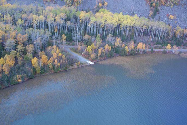
Figure 5 : Boat launch expansion
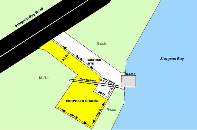
Enlarge Figure 5 : Boat launch expansion
3.3 Recreational activities
Existing recreational activities may continue provided that there are no threats to the natural ecosystems and features within the Conservation Reserve. Permissible activities include boating, fishing, hiking, hunting, scenic/wildlife viewing, snow mobiling/ATV use, and Crown land camping. ATV and snowmobile use is permitted on existing trails. Off trail use is not permitted except for direct retrieval of game. Horseback riding and mountain biking is permitted on existing trails as well. Rock climbing is permitted in suitable areas. Food gathering such as non-commercial berry picking is permitted.
3.4 Commercial activities
No commercial activities such as hydroelectric power development, new transmission lines (e.g. power or communications), pipelines, highways or roads, and the extraction of aggregates will be permitted. Development of future energy transmission and communication corridors should avoid Conservation Reserve lands wherever possible.
3.4.1 Forest management activities
The Conservation Reserve will be removed from the Lakehead Forest Land Base.
3.4.2 Commercial trapping activities
Trapping will continue as a permitted activity to the licensed trapline holders. No trapper’s cabins currently exist and new trappers cabins will not be permitted. New trapping operations will be considered subject to the "test of compatibility".
3.4.3 Bear Management Activities
There are currently two Bear Management Areas within the Conservation Reserve. Existing operations are permitted to continue. The islands within the Conservation Reserve are not within a BMA and new operations will not be permitted.
3.4.4 Commercial baitfish and commercial fishing activities
There are currently two active baitfishing blocks within the Conservation Reserve. These operations are permitted to continue and new operations will be considered subject to the "test of compatibility". Commercial fishing may exist in the bays adjacent to the Conservation Reserve. New off shore commercial fishing operations can be considered subject to the "test of compatibility".
3.4.5 Mining exploration and aggregate extraction activities
The mining rights in portions of the Western Lake Superior Conservation Reserve are in private ownership and are currently subject to forfeiture under the Mining Act. The Conservation Reserve cannot be regulated until the Ministry of Natural Resources has ownership of the mineral rights. The Crown owns the surface rights. Previous mining activity occurred in many locations including the mainland portions of the Prince Location and Spar Island. There are several mining hazards (e.g. shafts) known to be on Spar Island and these are under investigation by the Ministry of Northern Development and Mines. Others may exist on the remainder of the Prince Location. Future mining exploration and development is not be permitted.
3.5 Aboriginal interests
Western Lake Superior Conservation Reserve is within the Fort William First Nation land claim. The Ministry has committed that the site will not be regulated until there is a resolution of the claim. No other specific aboriginal interests have been identified.
3.6 Natural Resources Stewardship
3.6.1 Vegetation management
The OMNR recognizes fire as an essential process fundamental to the ecological integrity of this conservation reserve. On the mainland forest fire protection will be carried out as on surrounding lands. Consistent with past practices, fires occurring on islands in this conservation reserve will receive a monitored response which considers values at risk, adjacent values and projected weather and fire behavior.
"Light on the land" techniques, which do not unduly disturb the landscape, will be used wherever feasible when protecting sensitive features. Examples of light on the land techniques may include limiting the use of heavy equipment, and limiting the number of trees felled during fire response efforts.
Prescribed burning may be desirable in this conservation reserve and may be used to achieve resource management objectives. Opportunities for prescribed burning will be considered, and if identified, plans will be developed in accordance with the Prescribed Burn Planning Manual.
Forest insects and disease may be controlled in this Conservation Reserve where these threaten significant heritage, aesthetic, or economic values. Where control is desirable, it will be directed as narrowly as possible to the specific insect or disease. Biological control will be used where possible.
Fuel wood permits will not be issued. Collection and use of firewood for shore lunch and campfires is permitted.
3.6.2 Fisheries and wildlife management
Sport fishing and hunting will continue as permitted uses. No management action is required other than the implementation of existing Wildlife Management Unit and sport fishing regulations and management activities. Fish habitat management in this area is permitted.
3.6.3 Landforms
The landforms represented should not be altered through any landform modification activities, including filling and extracting of aggregates, peat, soil and any other similar materials.
3.7 Cultural Resources Stewardship
The identified archeological sites will be protected from disturbance. Due to the significance and sensitivity of these sites, the locations are confidential and are not shown on the values maps.
3.8 Client services
Information regarding this Conservation Reserve is available from the Thunder Bay District, to ensure that all resource users are aware of its location, access points, recognized values and permitted uses.
3.9 Research
Scientific research by qualified individuals that will contribute to the knowledge of natural and cultural history and to environmental and recreational management will be encouraged.
All research programs will require the approval of the Ministry of Natural Resources and will be subject to ministry policy and other legislation. The Ministry may approve the removal of any natural or cultural specimen by qualified researchers. All such materials removed remain the property of the Ministry of Natural Resources.
Approved research activities and facilities will be compatible with the protection objectives. Permanent plots or observation stations may be established to which researchers can return over time. Any site that is disturbed will be rehabilitated as closely as possible to its original state.
3.10 Marketing
Marketing efforts to increase use are not a priority and will be kept to a minimum. A fact sheet has been produced and is readily available to the public from either the Internet or through contact with the Thunder Bay District office.
4.0 Implementation
These management guidelines will be implemented by the Thunder Bay District, Lakehead Area Supervisor. Any MNR Resource Management Plans or Land Use Plans which include this area will be amended accordingly. Any affected clients will be immediately informed of the changes, should any arise. Administrative responsibility for the Conservation Reserve rests with the Lakehead Area Supervisor. Implementation will primarily involve monitoring activities to ensure adherence to the management guidelines.
5.0 Review and revisions
The Western Lake Superior Conservation Reserve Statement of Conservation Interest will be reviewed on an ongoing basis. If changes in management direction are required the significance of those changes will be evaluated. Minor changes that do not alter the overall protection objectives may be considered and approved by the District Manager. In assessing major changes, the need for a more detailed planningwill be considered. Major amendments will require approval by the Regional Director.
5.1 Public consultation
5.1.1 Results of past consultation
Consultation on the proposed Western Lake Superior Conservation Reserve was conducted as part of the consultation associated with the Ontario’s Living Legacy Land Use Strategy from 1997 through to 1999.
In August 2000, boundary consultation was undertaken with adjacent landowners, local First Nations, forest industry (Sustainable Forest License holders), the Local Citizens Committee, local trappers, Bear Management Area and baitfish license holders. Newspaper advertisements were placed in Thunder Bay’s Chronicle Journal and the Thunder Bay Post as well as the Wawatay.
No boundary adjustments were identified as a result of the public consultation phase.
During the boundary consultation the Fort William First Nation objected to the regulation of the Western Lake Superior Conservation Reserve. The issue identified was the impact of regulation on the Fort William land claim negotiations. This claim is in the very early stages of negotiation and final resolution is not anticipated for approximately five years. As a resultthe regulation of the Western Lake Superior Conservation Reserve has been deferred. This will allow the land claim negotiation to proceed in a manner uninhibited by any regulation decision by Ontario.
In 2003 the Municipality of Neebing requested permission to improve and expand an existing boat launch in Sturgeon Bay. The Class Environmental Assessment for Resource Stewardship and Facility Development (RSFD) was applied to the project and notice was provided to adjacent landowners, First Nations and the general public. The municipality and Fort William First Nation were given an opportunity to comment on the Statement of Conservation Interest (SCI). One comment in support of the project from a local residentwas received .No other comments were received.
6.0 References
Deschamps, Michael 2002. Area Biologist. Personal Correspondence. OMNR, Lakehead Area, Thunder Bay District.
Friday, Mike 2002. Management Biologist. Personal Correspondence. OMNR, Lake Superior Management Unit.
Geowest Environmental Consultants Ltd. 2000a. Earth Science Reconnaissance Survey. Summary Report for Western Lake Superior Conservation Reserve.
Geowest Environmental Consultants Ltd. 2000b. Life Science Reconnaissance Survey. Summary Report for Western Lake Superior Conservation Reserve.
Guel, J.J.C. 1970. Geology of Devon and Pardee Townships and Stuart Location, map 220, 1:31 680. Ontario Department of Mines and Northern Development, Geological Report 87.
Moore, Tracy 2000. OLL Recreational Inventory- Western Lake Superior – Jarvis Bay/ Prince Bay/ Mink Bay: Ministry of Natural Resources, Thunder Bay District.
Nixon, Donald 2002. Lakehead Area Forester. Personal Correspondence. OMNR, Thunder Bay District.
Noble, T.W. 1980. Life Science Report, Phase II, Site Region 4W, North Central Region. Ontario Ministry of Natural Resources.
Ontario Geological Survey 1991a. Bedrock Geology of Ontario, explanatory notes and Legend. Map 2545. Ontario Ministry of Natural Resources
Whyte, Pamela 2000. OLL Recreation Inventory- Western Lake Superior Conservation Reserve. Ministry of Natural Resources, Thunder Bay District.
Appendix 1
Western Lake Superior Conservation Reserve
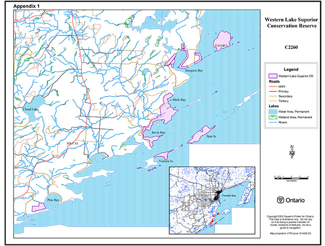
Enlarge Western Lake Superior Conservation Reserve