Westmeath Bog Conservation Reserve Management Statement
This document provides policy direction for the protection, development and management of the Westmeath Bog Conservation Reserve and its resources.
Statement of Conservation Interest (C43)
Approval statement
We are pleased to approve this Statement of Conservation Interest (SCI) for the proposed (C43) Westmeath Bog Conservation Reserve. It is one of 378 new protected areas approved through Ontario’s Living Legacy, a land use strategy aimed, in part, at completing Ontario’s system of parks and protected areas.
Located within the Ministry’s Pembroke District, the proposed (C43) Westmeath Bog Conservation Reserve is 43 hectares in size, comprising the west half of Lot 14, Concession 6, in the Township of Westmeath, Renfrew County.
This proposed conservation reserve, located in ecological Site District 6E-16 (formally referred to as Site District 5E-12), protects the Crown land portion of the Westmeath Bog Provincially Significant Wetland. The proposed conservation reserve is 43 ha of land that was acquired by the province through the Agriculture Rehabilitation Development Act (ARDA) program in 1977.
This proposed conservation reserve is situated within an area of eastern Ontario encompassed by the Algonquin Nation land claim. The Ministry of Natural Resources and the Algonquin Nation are developing a protocol to guide discussions on a number of land use matters, including implementation of Ontario’s Living Legacy Land Use Strategy .
The Westmeath Bog site has unique values that would benefit from protection at this time. The values at this site may be expanded in the future with the identification of other unique values through the protocol consultation process with the Algonquins. This SCI will protect the values of this site during the consultation process.
This Statement of Conservation Interest provides guidance for the management of the proposed Westmeath Bog Conservation Reserve and provides the basis for the ongoing monitoring of activities. More detailed direction is not anticipated at this time.
The proposed Westmeath Bog Conservation Reserve is managed under the jurisdiction of the Madawaska Area Supervisor, Pembroke District, Ministry of Natural Resources.
Approved by:
Ray Bonenberg
District Manager
Pembroke District
Approved by:
Ron Running
Regional Director
Southcentral Region
1.0 Introduction
The purpose of this Statement of Conservation Interest (SCI) is to identify and describe the values of the proposed Westmeath Bog Conservation Reserve. The SCI also outlines the activities that occur within the proposed reserve and provides guidelines for the management of current and future activities in the context of protecting the natural and cultural values.
Located within the Ministry’s Pembroke District, the proposed (C43) Westmeath Bog Conservation Reserve is 43 hectares in size, comprising the west half of Lot 14, Concession 6, Westmeath Township, Renfrew County (see Figure 2).
This proposed conservation reserve, located in ecological Site District 6E-16 (formally referred to as Site District 5E-12), protects the Crown land portion of the Westmeath Bog Provincially Significant Wetland. The proposed conservation reserve is 43 ha of land that was acquired by the province through the Agriculture Rehabilitation Development Act (ARDA) program in 1977.
Prior to the finalization of the boundaries of the proposed Westmeath Bog Conservation Reserve, Pembroke District MNR staff sent out boundary consultation packages on November 12, 1999 to potentially affected stakeholders (adjacent landowners, resource users, municipalities, interest groups, and organizations), inviting comment on the proposed boundaries. Boundary consultation packages were also sent out to provincial interest groups and organizations. In addition, public notices were placed in local newspapers.
There were no significant issues raised during public consultation and only six responses received. One suggestion encouraged periodic review of hunting and fishing under management plans for all conservation reserves. In addition, an adjacent landowner conveyed their interest in selling property to the Crown (Con 5, Lot 14).
Conservation Reserves are established by Regulation under the Public Lands Act. Statements of Conservation Interest are prepared under the authority of Procedural Guideline A – Resource Management Planning (PL Procedure 3.03.05).
1. 1 Background information
| Name | Westmeath Bog Conservation Reserve |
|---|---|
| Ecological Site Region / Site District | 6E-16 (formally 5E-12) |
| OMNR Administrative Region/District/Area | Southcentral Region / Pembroke District / Madawaska Area |
| Total Area (hectares) | 43 hectares |
| Regulation Date | Pending |
| First Nations Interests | Algonquin Nation |
| OBM map sheets | 10 18 3500 50650 10 18 3500 50700 10 18 3550 50650 10 18 3550 50700 |
| UTM Coordinates | Reference # 550700 (NAD 83) |
Figure 1: Conservation Reserves in Pembroke District
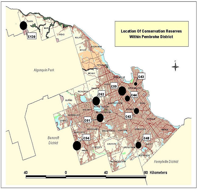
Enlarge Figure 1: Conservation Reserves in Pembroke District
Figure 2: Location Map
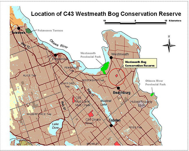
Enlarge Figure 2: Location Map
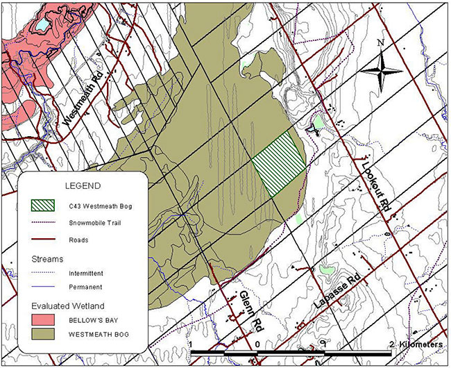
Figure 3: Site Map
1.2 Representation/targets
Earth science representation:
This site does not contribute to provincial earth science representation targets. For elaboration on the earth science values see Section 2.1.
Life science representation:
While the site contributes to the life science values of Site Region/District 6E-16 (formally known as 5E-12), it primarily serves to protect the Crown land portion of a Provincially Significant Wetland (PSW). The proposed conservation reserve contains the best representation of bog ecosites in Ecodistrict 6E-16, with vegetative species present that are often more typical of northern bog ecosystems.
Cultural resources representation:
Cultural resources inventories have not been completed for this proposed conservation reserve. There are no know specific cultural resources, however the area is known to have a history of occupation spanning 5000 to 6000 years (Archaic; Early, Middle and Late Woodland; Early Historic) (Dillon Consulting, 1995).
1.3 Survey information
This section provides an overview of the inventories completed, their level of detail and any further inventory work required.
| Survey level | Earth sciences | Life sciences | Cultural | Recreational | Other |
|---|---|---|---|---|---|
| Reconnaissance | No | ✓ | ✓ | ✓ | Wetland evaluation (Beaudette and Buckland, 1985) |
| Detailed | No | No | No | No | No |
| Requirement | No | Yes | No | No | No |
2.0 Values to be protected
This section provides a description of the key natural heritage values of the site and their condition relative to past and present resource use and management activities. It also addresses the sensitivity of these values to future land use and management activities.
This proposed conservation reserve is located within Hills (1959) ecological Site District 6E-16 (formally 5E-12). Values include earth science, life science and recreational features.
2.1 Earth science
Earth science values are focused on features (bedrock and surficial) that represent the chronology of earth history in the province (Davidson 1981).
A ridge of gravel and sand lies east of the reserve, providing a lookout over the bog, and directing surface water towards it, however the reserve itself is overlain entirely by organic material.
Because there is an absence of exposed bedrock within the proposed Westmeath Bog Conservation Reserve, the site has no geological significance to Ontario’s protected area system and thus does not contribute to provincial earth science representation targets.
2.2 Life science
The proposed Westmeath Bog Conservation Reserve is located within Hills' (1959) ecological Site District 6E-16 (formally 5E-12).
Representation:
The proposed Westmeath Bog Conservation Reserve consists of the Crown-owned portion of the much larger, provincially significant, Westmeath Bog. The proposed conservation reserve contains the best representation of bog ecosites in Ecodistrict 6E-16, with vegetative species present that are often more typical of northern bog ecosystems.
The forested area contains an overstory of mainly larch, black spruce and white cedar. The Forest Resource Inventory overestimates the amount of white cedar present, as most treed areas are tamarack, tamarack-spruce, or spruce-tamarack. Small balsam poplar, white elm and black ash are also present. Open areas are diverse, including tall shrubs, ericaceous shrubs, grasses and sedges, and sphagnum/feathermoss mats. Ecosites are rarely extensive; rather they are found as a mosaic of small patches.
Ecosites present include: Open Bog (B001); Shrub Bog (BOS1); Treed Bog (BOT1); Open Fen (FEO1); Shrub Fen (FES1); Treed Fen (FET1); White Cedar Organic Coniferous Swamp (SWC3); and Tamarack –Black Spruce Organic Coniferous Swamp (SWC4) (based on interpretation of the Ecological Land Classification for Southern Ontario, Lee et al, 1998). Within these ecosites are at least 14 Vegetation Types.
While the Westmeath Bog provides good representation of the above-described communities, the parcel was originally identified for protected area regulation due to its significant wetland values, not on the basis of life science representation.
Condition:
The proposed reserve appears undisturbed by man or natural disturbance. During field visits in the summer of 2001 it was noted that the tamarack appeared to be in decline, with orange or orange-tipped and sometimes sparse needles. Black spruce is growing up under the tamarack.
Diversity:
Most of the ecosites present within the proposed reserve are varieties of bog and fen, with swampy areas occurring near the edge of the bog. The diversity of this proposed reserve lies in the interspersion of many small areas of different ecosites. Among these areas, shrub, herb and moss diversity is also high with many species of orchid present, some being found in abundance.
The ecosystems found within the proposed Westmeath Conservation Reserve are preferred habitat for a number of small mammals and amphibians, and used by many more (Bellhouse and Naylor, 1997).
Ecological considerations:
The bog ecosystems have many fragile elements, such as sphagnum mounds, orchid "fields", delicate understorey vegetation, and water pools, which are very susceptible to damage by vehicles and even foot traffic. Because of the unique nature of the bog in this Ecodistrict, protection of these fragile elements should be of primary importance in management planning.
Because there are few wetlands in Ecodistrict 6E-16, the Westmeath Bog plays a significant role in filtering agricultural runoff, as well as providing flood control and water storage.
Special features:
As mentioned, the proposed conservation reserve represents 43 ha of the Provincially Significant Westmeath Bog and thus has the potential to provide habitat for northern bog species as well as locally, regionally and provincially significant species. The orchid diversity and abundance is of special note and should be inventoried in greater detail.
Significance:
Because there are few wetlands in Ecodistrict 6E-16, the Westmeath Bog plays a significant role in providing a variety of wetland habitat types along with associated features and functions such as filtering agricultural runoff, as well as providing flood control and water storage. The Westmeath bog has been evaluated as a provincially significant wetland.
2.3 Recreational values
The recreational value of the site is primarily local in nature, restricted to adjacent landowners that may utilize the site for hunting activities. There has been some interest exhibited by local naturalists who wish to access the site for the purpose of research, nature appreciation and photography. This is a recreational value that is currently underutilized due to the access limitations.
3.0 Management guidelines
3.1 Land tenure
Background:
The proposed Westmeath Bog Conservation Reserve is comprised of 1 parcel of Crown land (west half of Lot 14, Concession 6, Westmeath Township), 43 hectares in size, that was acquired by the Province in 1977 through the Agriculture Rehabilitation Development Act (A.R.D.A.) Program. There are currently no existing licences, leases or permits associated with this site.
The site is completely surrounded by privately owned land with no trail or road access. Six responses were received during the public consultation stage that took place in November and December 1999. Responses were primarily limited to requests for additional information and did not reflect boundary issues. One respondent expressed interest in selling property, adjacent to the reserve, to the Crown (Con 5, Lot 14).
Guideline:
Sale of Crown lands within the proposed conservation reserve is not permitted, with the exception of some types of minor dispositions.
Leasing of Crown lands within the proposed conservation reserve for the development of private camps is not permitted.
Leasing of Crown lands to new commercial outfitting services, outpost camps, resort or lodges can be considered during future planning, however, it is very unlikely that such use will be proposed in this site, due to its small size and unsuitability for such activities. Currently, there are no "remote" based tourism lodges or camps on Crown land with exclusive tenure to an area in Pembroke District. There are numerous lodges, resorts, motels and cottages on private land which house tourists who use nearby Crown land and lakes for recreation activities (Yaraskavitch, ca 1997-98).
Lands that would enhance the proposed conservation reserve, by incorporating more of the provincially significant wetland, or by providing public access to the site, may be acquired by the Ministry if funding and/or contributing partners become available.
While there are no known unauthorized occupations of lands within the proposed conservation reserve, such occupations would be handled in accordance with approved policy, and any required structural removal will be undertaken at the owner’s expense.
3.2 Existing/proposed development
Background:
There is currently no known development on the site and no intention at this time to improve site development (facilities, access, and trails).
Access to the site is limited to those who occupy adjacent lands and those who obtain express permission to cross private land.
The Crown portion of the Westmeath Bog is inaccessible by road and is surrounded by private lands. However a snowmobile/all-terrain vehicle (ATV) trail runs close to one corner of the proposed reserve. The bog ecosystems have many fragile elements, such as sphagnum mounds, orchid "fields", delicate understorey vegetation, and water pools, which are very susceptible to damage by vehicles and even foot traffic.
Guideline:
Due to the unique nature of the bog in this Ecodistrict, protection of these fragile elements should be of primary importance in management planning.
New trails are not encouraged, however, they may be considered when compatible with other recreational uses, the maintenance of environmental integrity, and the requirements of Procedural Guideline B – Test of Compatibility (Appendix 1). Any new trails will be designed to discourage access by any means other than on foot and will avoid those areas identified as sensitive to disturbance, or supporting provincially, regionally, or locally important plant species.
Facility infrastructure and development for recreational and/or educational purposes may be considered in the future if there is a demonstrated demand for such facilities. A more detailed management plan would be required at that time.
All provincial policies that guide development (i.e. water hazard management, wetlands) are applicable in conservation reserves as on Crown land.
3.3 Recreational activities
Background:
The recreational value of the site is primarily local in nature, restricted to adjacent landowners that may utilize the site for hunting activities. There has been some interest exhibited by local naturalists who wish to access the site for the purpose of research, nature appreciation and photography.
The proposed conservation reserve is situated within Wildlife Management Unit 59 where hunting for deer, moose, black bear, small game, waterfowl and wild turkey is permitted.
There are no known snowmobile trails on the site however the Trans-Ontario Provincial Trails System (TOPS) passes very close to the southeast boundary.
Guideline:
Most recreational activities that have traditionally been enjoyed in this area can continue provided they pose no threat to the natural ecosystems and features protected by the proposed conservation reserve. Non-regulated permitted uses include wildlife viewing, hiking, snowshoeing, cross country skiing, exploring, and snowmobiling. Hunting may continue as a regulated use.
3.4 Commercial activities
Background:
The are currently no commercial activities associated with the proposed Westmeath Bog Conservation Reserve.
Guideline:
Conservation reserves do not permit commercial forest harvesting, hydroelectric power development, the extraction of aggregate, peat, soils, or other industrial uses. (Public Lands Act, Ontario Regulation 805/94).
Mineral exploration and mining are not permitted within the proposed Westmeath Bog Conservation Reserve.
Other new commercial activities such as commercial fur harvesting can be considered, subject to the requirements of Procedural Guideline B – Test of Compatibility (Appendix 1).
3.5 Aboriginal interests
Background:
The proposed conservation reserve is located within the land claim area of the Algonquin Nation.
There is no known documented use of the proposed conservation reserve by Algonquins or other Aboriginal peoples.
Guideline:
The Ministry of Natural Resources and the Algonquin Nation are developing a protocol to guide discussions on a number of land use matters, including implementation of the Ontario’s Living Legacy Land Use Strategy. The Westmeath Bog site has unique values that would benefit from protection at this time. The values at this site may be expanded in the future with the identification of other unique values through the protocol consultation process with the Algonquins.
Hunting and fishing are permitted uses in all proposed conservation reserves, although there are not any fishing opportunities in this particular proposed conservation reserve.
3.6 Natural Resource Stewardship
3.6.1 General
The proposed conservation reserve will be managed with an emphasis on ensuring that the natural ecosystems and processes of the proposed conservation reserve are not negatively affected by current and future activities. Therefore, applications for specific uses will be carefully studied and reviewed. The Ministry, partner organizations, and/or the proponents may undertake such studies.
3.6.2 Vegetation management and fire management
Background:
The proposed Westmeath Bog Conservation Reserve contains the best representation of bog ecosites in Ecodistrict 6E-16, with vegetative species present that are often more typical of northern bog ecosystems. Open areas are diverse, and ecosites are found as a mosaic of small patches. Many species of orchid are present, with some being found in abundance.
With respect to the forest overstory, the Forest Resource Inventory overestimates the amount of white cedar present, as most treed areas are tamarack, tamarack-spruce, or spruce-tamarack. Small balsam poplar, white elm and black ash are also present. During field visits in the summer of 2001 it was noted that the tamarack appeared to be in decline.
The proposed reserve appears undisturbed by man or natural disturbance.
As mentioned, the proposed conservation reserve represents 43 ha of the 860 ha Provincially Significant Westmeath Bog and thus has the potential to provide habitat for northern bog species as well as locally, regionally and provincially significant species.
Guideline:
As stated in the Ontario’s Living Legacy Land Use Strategy (1999), the Ministry of Natural Resources will work with the municipality and private landowners on protection of the private land portion of the wetland.
The proposed conservation reserve will be managed by allowing natural ecosystems, processes and features to operate normally, with minimal human interference or alteration.
Conservation reserve policy states that forest fire protection will be carried out as on surrounding public lands, unless it is determined through management planning that another approach should be undertaken. Pembroke District MNR has a policy of aggressively suppressing all fires. The MNR would appropriately respond to any fire as per policy or municipal agreements at any such time, with a "light on the land" approach (ie. no bulldozers, no camp construction, minimal cutting).
Programs may be developed to control forest insects and diseases in the proposed conservation reserve where these threaten significant natural heritage, aesthetic, or economic values. Where control is desirable, it will be directed as narrowly as possible to the specific insect or disease. The methods selected will be subject to the requirements of Procedural Guideline B – Test of Compatibility (Appendix 1).
Any wetland habitat alterations would be reviewed on a case by case basis, with consideration given to; protection of natural heritage values, MNR's environmental assessment responsibilities and provincial conservation reserve policy.
Invasive species which are deemed to threaten the natural heritage values of the proposed conservation reserve will be managed using acceptable and approved controls which protect natural heritage values and are subject to Procedural Guideline B – Test of Compatibility (Appendix 1).
MNR will work with municipalities and private landowners to protect private land portions of the provincially significant wetland, through land tax incentives, co-stewardship opportunities and through municipal land use planning. Landowners with property in the provincially significant wetland may be eligible for the Conservation Land Tax Incentive Program, providing they meet the program criteria and agree to protect the natural heritage values of their property. Protection of the wetland can also be promoted by municipal consideration of the Provincial Policy Statement and Planning Act within planning documents and through development review.
3.6.2 Wildlife management
Background:
The proposed conservation reserve is situated within Wildlife Management Unit 59 where hunting for deer, moose, black bear, small game, waterfowl and wild turkey is permitted.
There is currently no bait-fish harvesting or fur harvesting taking place within the proposed Westmeath Bog Conservation Reserve.
Rabbit, grouse, songbirds and wood frog were observed during the reconnaissance life science survey (2001) however little evidence of the larger species of wildlife was noted. The ecosystems found within the proposed Westmeath Conservation Reserve are preferred habitat for a number of small mammals and amphibians, and used by many more (Bellhouse and Naylor, 1997).
Guideline:
Hunting within the proposed conservation reserve is permitted and will be guided by the relevant Ontario hunting regulations. New commercial fur harvesting operations can be considered, subject to the requirements of Procedural Guideline B – Test of Compatibility (Appendix 1). Fur harvesting would be managed through the current licence system.
Invasive species which are deemed to threaten the natural heritage values of the proposed conservation reserve will be managed using acceptable and approved controls which protect natural heritage values and subject to Procedural Guideline B – Test of Compatibility (Appendix 1).
3.7 Cultural Resource Stewardship
Background:
The protection and conservation of cultural heritage resources is governed by the Ontario Heritage Act and administered by the Ministry of Culture. There are no known cultural/historic features and archeological features identified on site although Aboriginal and historical values have been identified in the area.
Guideline:
Interested partners with the appropriate qualifications would be allowed to undertake inventories and studies of the area, consistent with Procedural Guideline C - Research Activities in Conservation Reserves (Appendix 2). The specific location of cultural heritage sites will be kept confidential to protect the resources.
3.8 Client services
Background:
Client services (such as interpretation, access and signage) associated with the site are limited to a brief informative fact sheet that was developed during the public consultation phase in 1999. No services or facilities are presently provided within the site boundaries. The Fact Sheet for the proposed Westmeath Bog Conservation Reserve is currently availa ble to the public through the Pembroke District office or via the internet at: www.ontarioslivinglegacy.com. (Link no longer active)
Guideline:
Given the focus on low key management, client information will be given on an inquiry basis only and will deal with the basic level of information with respect to access, natural heritage appreciation, recommended activities, and boundaries.
3.9 Research
Background:
Beaudette and Buckland completed a wetland evaluation of the Westmeath Bog in 1985. It was found that the Westmeath Bog ranked as Provincially Significant within Ontario.
As part of the responsibilities associated with the regulation of the proposed Westmeath Bog Conservation Reserve, a life science checksheet (Appendix 3) and recreation checksheet (Appendix 4) were completed in 2002. Both can be found on file with the Ministry of Natural Resources at the Pembroke District office.
Guideline:
Non-destructive research by qualified individuals will be encouraged to provide a better understanding of the natural values protected by the proposed Westmeath Bog Conservation Reserve and to advance protection, planning and management. Research proposals and activities must follow Procedural Guideline C – Research Activities in Conservation Reserves (Appendix 2).
All research programs will require the approval of the Ministry of Natural Resources as will the removal of any natural or cultural specimen. The establishment of permanent plots, observation points or facilities must also be approved and be compatible with the conservation reserve protection objective. Any site disturbed by research activities must be rehabilitated as closely as possible to its previous state.
The researcher will submit copies of reports, publications, theses and results to the MNR Madawaska Area Supervisor.
3.10 Marketing
Background:
There has been no direct marketing of the proposed Westmeath Bog Conservation Reserve boundary to date. Promotion and information about this site has been primarily through the Ontario’s Living Legacy planning process, through the 1999 MNR public consultation regarding proposed regulation and boundary refinement of the site and through the Living Legacy web site at: www.ontarioslivinglegacy.com (Link no longer active) .
Guideline:
Intensive marketing activity to increase use, is neither desired nor required at this time. Fact sheets about this proposed conservation reserve will continue to be available on an inquiry basis, to inform the public about the special values of this area and the role of this proposed conservation reserve in Ontario’s protected area system.
4.0 Implementation
Administrative responsibility for the proposed Westmeath Bog Conservation Reserve lies with the Madawaska Area, Pembroke District, Ministry of Natural Resources.
The Area Office will continue with the custodial care of the proposed conservation reserve and will also seek out partnerships where appropriate. Implementation of this Statement of Conservation Interest will primarily involve monitoring activities to ensure adherence to the management guidelines.
Implementation priorities include:
- consultation with Algonquin First Nation representatives and communities, as a basis of proceeding with final boundary refinement and regulation of this proposed conservation reserve
- updating this SCI upon final regulation as a conservation reserve
- undertaking additional life science inventory and research
- investigation of potential adjacent land acquisition
- the Ministry of Natural Resources will work with municipality and private landowners on protection of the private land portion of the wetland; and
- Investigation of minor development to increase public access, as funding permits
- providing client services (e.g. brochure or fact sheet) at nearby MNR Offices
5.0 Review and revision of the Statement of Conservation Interest
The proposed Westmeath Bog Conservation Reserve Statement of Conservation Interest will be reviewed on an ongoing basis.
If changes are required in the Statement of Conservation Interest, they will occur through a standard process of minor and major amendments. Minor amendments will be processed in a relatively informal manner and will require the approval of the Area Supervisor. These amendments will deal with uses and activities that do not affect any of the policies in this SCI, such as new uses and/or activities that are consistent with existing uses.
Uses and/or activities that were not anticipated in the approved SCI and which have the potential to have a negative impact on the values of this proposed conservation reserve will require a major amendment. This will include an opportunity for public comment and input, will require the approval of the District Manager and Regional Director.
References
Beaudette, S. and L. Buckland. 1985. Wetland Data Record and Evaluation – Westmeath Bog. Ontario Ministry of Natural Resources.
Bellhouse, T.J. and B.J. Naylor. 1997. Habitat relationships of wildlife in Central Ontario. OMNR, SCS Technical Report No. 53
Davidson R. J. 1981. A framework for the conservation of Ontario’s earth science features. Ontario Ministry of Natural Resources, Toronto.
Dillon Consulting Limited. Final Technical Reports: Highway 17 Environmental Assessment— Haley Station to Meath Hill—Terrestrial Biology and Wetlands. December 1997.
Hills, G. A. 1959. A ready reference to the description of the land of Ontario and its productivity. Ontario Department of Lands and Forests, Division of Research, Maple, Ontario.
Lee, Harold, Bakowsky, Wasyl, Riley, John, Bowles, Jane, Puddister, Michael, Uhlig, Peter , and McMurray, Sean. Ecological Land Classification for Southern Ontario: First Approximation and it’s Application. 1998.
Noble T. W. 1983. Biophysiographic Analysis of Site Region 5E. Central (Algonquin) Region, Ontario Ministry of Natural Resources.
Ontario Ministry of Natural Resources, 1983. Pembroke District Land Use Guidelines. Pembroke District, Algonquin Region, Ontario Ministry of Natural Resources
Ontario Ministry of Natural Resources. Conservation reserve Policy PL 3.03.05, Lands and natural Heritage Branch, Peterborough.
Ontario Ministry of Natural Resources, 1999. Ontario’s Living Legacy, Land Use Strategy, July 1999. Ontario Ministry of Natural Resources, Peterborough.
Yaraskavitch, Joe. circa 1997-98. Pembroke District-Resource Based Tourism (excerpts from), OMNR.
Appendix 1
Procedural Guideline B – Land Uses – Test of Compatibility (PL Procedure 3.03.05)
The Conservation Reserve policy provides broad direction with regard to the permitted uses. The policy provides only an indication of the variety of uses that will be considered acceptable in Conservation Reserves. The only caution is that "any new uses, and commercial activities associate d with them, will be considered on a case by case basis, and, they must pass a test of compatibility to be acceptable. "
What does a 'test of compatibility' mean? An examination of this must start from the premise of why an area is set aside – specifically, its representative natural heritage values. Criteria are then identified to guide compatibility considerations. These criteria apply to the long-term acceptability of both existing uses and new uses.
-
Conformity to SCI/RMP: SCI describes values for which an area has been set aside and the range of appropriate uses that will be permitted in the area. SCI may also speak to the acceptability of other 'new' uses currently not occurring in the area.
The first 'test' is: "do proposed new land uses and/or commercial activities conform to the direction of the SCI/RMP for the Conservation Reserve? Would the new use(s ) depart from the spirit of appropriate indicator land uses in the SCI/RMP?"
- Impact Assessment: If the proposed use(s) pass test 1 it is important to determine their impact on the area before they are approved. This should include the following:
- Impact on natural heritage values: "will the new use(s) impact any natural values in the area? If so how and to what degree? Is it tolerable?"
- Impact on cultural values: "will the new use(s) impact an historical or archaeological values in the area?"
- Impact on research activities: "will the new use(s) affect research activities in the area?"
- Impact on current uses: "will the new use(s) have any negative impact on the array of current uses?"
- Impact on area administration: "will the new use(s) increase administrative costs and/or complexity?" (For example, the cost of area monitoring, security and enforcement).
- Impact on accommodating the use outside the Conservation Reserve: "Could the use(s) be accommodated as well or better outside the Conservation Reserve?"
- Impact on socio-economics of the area: "will the new use(s) affect the community (ies) surrounding the area in a positive or negative way?" (For example, will the new use make an area less remote thereby affecting a local tourism industry that is dependent on the area’s remoteness for its appeal?"
- Impact on area accessibility: "does the new use(s) give someone exclusive rights to the area or a portion of the area to the exclusion of other existing uses?"
Indicator uses for Conservation Reserves
Industrial activities
| Activity | Generic OLL Policy Permitted? Existing |
Generic OLL Policy Permitted? New |
Specific Application In Proposed Westmeath Bog Conservation Reserve Existing |
Specific Application In Proposed Westmeath Bog Conservation Reserve New |
|---|---|---|---|---|
| Commercial timber harvest | No | No | No | No |
| Cutting of trees by leaseholders and property owners for fuelwood and small-scale uses | Maybe | Maybe | Maybe | Maybe |
| Timber salvage/sunken log retrieval | Maybe | Maybe | Maybe | Maybe |
| Mineral exploration | No | No | No | No |
| Mining | No | No | No | No |
| Extraction of peat, soil, aggregate, other materials | No | No | No | No |
| Forest renewal | Maybe1 | Maybe1 | Maybe1 | Maybe1 |
| Hydro power generation | No | No | No | No |
| Communications corridors | Yes | No2 | Yes | No2 |
| Energy transmission corridors | Yes | No2 | Yes | No2 |
| Transportation corridors | Yes | No2 | Yes | No2 |
| Resource access roads | Maybe2 | Maybe2 | Maybe2 | Maybe2 |
| Private access roads | Yes | No3 | Yes | No3 |
Recreation activities
| Activity | Generic OLL Policy Permitted? Existing |
Generic OLL Policy Permitted? New |
Specific Application In Proposed Westmeath Bog Conservation Reserve Existing |
Specific Application In Proposed Westmeath Bog Conservation Reserve New |
|---|---|---|---|---|
| Sport fishing | Yes | Yes | N/A | N/A |
| Sport hunting | Yes | Yes | Yes | Yes |
| Facility development | Maybe | Maybe | Maybe | Maybe |
| Non-trail snowmobiling | Maybe4 | Maybe4 | Maybe4 | Maybe4 |
| Non-trail ATV use | Maybe4 | Maybe4 | Maybe4 | Maybe4 |
| Motorized boating | Yes | Yes | N/A | N/A |
| Camping | Maybe | Maybe | Yes | Yes |
| Trails: hiking | Yes | Maybe | Yes | Maybe |
| Trails: snowmobiling | Yes | Maybe | Yes | Maybe |
| Trails: cycling | Yes | Maybe | Yes | Maybe |
| Trails: horse riding | Yes | Maybe | Yes | Maybe |
| Trails: cross-country skiing | Yes | Maybe | Yes | Maybe |
| Private recreation camps | Yes5 | No | Yes5 | No |
1If a new conservation reserve has been recently cut, companies have an obligation to proceed with renewal. It can be conducted where it will be of net benefit to the protected area and to, the greatest extent possible, it should be designed to replicate natural conditions.
2The intent is to actively discourage these uses, but it is recognized that in some circumstances these will be no alternative; this will be determined through planning.
3New private access roads, including additions to existing roads, will not be permitted except where there are previous commitments that were made prior to March 29, 1999. Such commitments will be subject to the completion of a public planning process.
4Use may be permitted for the direct retrieval of game only.
5Existing private recreation camps are eligible for enhanced tenure but not for the purchase of lands. A decision to grant enhanced tenure, or to transfer recreational camps will be addressed though a screening process.
Commercial activities
| Activity | Generic OLL Policy Permitted? Existing |
Generic OLL Policy Permitted? New |
Specific Application In Proposed Westmeath Bog Conservation Reserve Existing |
Specific Application In Proposed Westmeath Bog Conservation Reserve New |
|---|---|---|---|---|
| Fishing | Yes6 | Maybe | N/A | N/A |
| Bait-fish harvesting | Yes6 | Maybe | N/A | N/A |
| Commercial fur trapping | Yes6 | Maybe | Yes6 | Maybe |
| Trapping cabin | Yes | No | Yes | No |
| Out-post camps/tourism facilities | Maybe7 | Maybe7 | Maybe7 | Maybe7 |
| Commercial bear hunting (tourist operators) | Yes | No | Yes | No |
| Wild rice harvesting | Yes6 | Maybe | Yes6 | Maybe |
| Food harvesting | Maybe | Maybe | Maybe | Maybe |
Resource management activities
| Activity | Generic OLL Policy Permitted? Existing |
Generic OLL Policy Permitted? New |
Specific Application In Proposed Westmeath Bog Conservation Reserve Existing |
Specific Application In Proposed Westmeath Bog Conservation Reserve New |
|---|---|---|---|---|
| Resource inventorying | Yes | Yes | Yes | Yes |
| Resource monitoring | Yes | Yes | Yes | Yes |
| Fire protection | Yes | Yes | Yes | Yes |
| Insect and disease | Maybe | Maybe | Maybe | Maybe |
| Featured species management | Maybe | Maybe | Maybe | Maybe |
Other activities
| Activity | Generic OLL Policy Permitted? Existing |
Generic OLL Policy Permitted? New |
Specific Application In Proposed Westmeath Bog Conservation Reserve Existing |
Specific Application In Proposed Westmeath Bog Conservation Reserve New |
|---|---|---|---|---|
| Research | Yes | Yes | Yes | Yes |
| Collecting | Maybe8 | Maybe8 | Maybe8 | Maybe8 |
| Food gathering | Yes | Yes | Yes | Yes |
| Land disposition | Yes9 | Maybe9 | Yes9 | Maybe9 |
| Habitat management for wildlife | Maybe10 | Maybe10 | Maybe | Maybe |
6Existing use permitted to continue, unless there are significant demonstrated conflicts. New operations can be considered, subject to the 'test of compatibility.'
7Existing authorized tourism facilities can continue unless there are demonstrated conflicts. The operators of tourism facilities can apply to upgrade tenure from LUP to lease. New tourism facilities can be considered during planning for a conservation reserve.
8Must be part of an authorized research project.
9Sale of lands is not permitted with the exception of some minor types of dispositions where it does not detrimentally affect the values an area is intended to protect. Renewals of existing leases or land use permits are permitted. Requests for transfer of tenure will be considered in the context of the SCI. New leases or land use permits will be allowed for approved activities.
10A specific policy was not identified in the OLL Land Use Strategy, although specific management prescriptions will be identified in the context of an SCI.
Appendix 2
Procedural Guideline C – Research Activities in Conservation Reserves
Purpose
To encourage contributions to the goal of conservation reserves by:
- providing direction for research activities associated with conservation reserves; and
- establishing a process for the review and approval of proposals by researchers, which could have an impact on the values protected by the conservation reserve
Definition
Research means any investigation or study of the natural, cultural, social, economic, management or other features or characteristics of conservation reserves.
Guidelines
Research will be encouraged to provide a better understanding of the natural values protected by a conservation reserve and to advance their protection, planning and management. The Statement of Conservation Interest will define, for each conservation reserve, the key research issues, set out the parameters within which research may occur and identify research needs.
Applications and approvals
Researchers must apply in writing to the Area Supervisor for permission to conduct research. The request letter must contain a statement explaining why the proposed research should be undertaken in the particular conservation reserve in preference to another location.
Proposals will be reviewed and approved by the Area Supervisor, guided by the Statement of Conservation Interest prepared for each reserve (see Guideline A – Resource Management Planning) and using Guideline B – Land Uses – Test of Compatibility. Permission must be granted in writing, including any conditions to be met in conducting the research, prior to the undertaking of any research project .
Terms and conditions
Permission to conduct research under this policy will be valid for a period of 12 consecutive months from date of issue. Permission to continue a research project for additional periods of 12 months or less may be granted upon submission of a written request and progress report. The Ministry may require the posting of collateral to assure that the terms and conditions of granting permission are met.
The Area Supervisor may suspend or revoke permission at any time for failure on the part of the researcher to meet:
- The intent or conditions of this policy
- The requirements under the Public Lands Act, including all amendments, where applicable
- The requirements under any other Act or Regulations of Ontario or Canada, including those governing the taking, handling, storing, confining, trapping, excavating and marketing any specimen, artifact, information or action (for example, scientific collector’s permit)
- The conditions and agreements specified in granting permission
Final report
The researcher will submit copies of reports, publications and theses following from the results of the project to the Area Supervisor.