Government Notices Respecting Corporations
Certificate of Dissolution
Notice Is Hereby Given that a certificate of dissolution under the Business Corporations Act, has been endorsed. The effective date of dissolution precedes the corporation listings.
|
Date |
Name of Corporation |
Ontario Corporation Number |
|---|---|---|
|
2002-11-06 |
Glamorgan Day Nursery Limited |
467925 |
|
2002-11-13 |
D&J Auto Sales Limited |
619316 |
|
2002-11-15 |
Canada Computer & Electronics Incorporated |
1034276 |
|
2002-11-15 |
Fifty-Four Capital Corporation |
866088 |
|
2002-11-15 |
Genesis Aviation Ltd. |
570895 |
|
2002-11-15 |
Mon-Ray Fashions Company Limited |
410698 |
|
2002-11-15 |
No Real Estate Fees.Com Ltd. |
1476894 |
|
2002-11-15 |
Rodemi Inc. |
869210 |
|
2002-11-15 |
Whitfield Home Services Inc. |
1486552 |
|
2002-11-15 |
1338109 Ontario Ltd. |
1338109 |
|
2002-11-15 |
770326 Ontario Inc. |
770326 |
|
2002-11-18 |
Computer Letters Limited |
262045 |
|
2002-11-18 |
Macanbro Micro Centres Ltd. |
665076 |
|
2002-11-18 |
Pain Inc. |
1488347 |
|
2002-11-18 |
Pelee Natural Products Inc. |
851384 |
|
2002-11-18 |
Rasquinha Holdings Ltd. |
646793 |
|
2002-11-18 |
1080981 Ontairo Limited |
1080981 |
|
2002-11-18 |
1100497 Ontario Inc. |
1100497 |
|
2002-11-18 |
783935 Ontario Inc. |
783935 |
|
2002-11-26 |
John B. Cesarin Electrical Contractor Ltd. |
360136 |
|
2002-11-29 |
Al Martin & Sons Enterprises Limited |
663617 |
|
2002-11-29 |
Al Norman Services Inc. |
887505 |
|
2002-12-02 |
Marta Rauti Consultants Inc. |
1133391 |
|
2002-12-03 |
D. & G. Packaging Consultants Ltd. |
1079828 |
|
2002-12-03 |
G. H. Robinson Construction Company Limited |
145519 |
|
2002-12-04 |
Esskay Consulting Inc. |
1134646 |
|
2002-12-04 |
Morjul Investments Limited |
140279 |
|
2002-12-04 |
1125841 Ontario Inc. |
1125841 |
|
2002-12-04 |
1454703 Ontario Ltd. |
1454703 |
|
2002-12-04 |
548322 Ontario Ltd. |
548322 |
|
2002-12-04 |
706739 Ontario Limited |
706739 |
|
2002-12-05 |
Aesthetics By Marianne Inc. |
1371416 |
|
2002-12-05 |
Clearwater Civil Contracting Ltd. |
755221 |
|
2002-12-05 |
G.N.H. Roofing And Sheet Metal (1991) Limited |
947569 |
|
2002-12-05 |
Hedges Mechanical Ltd. |
892348 |
|
2002-12-05 |
Jadoram-West Limited |
99825 |
|
2002-12-05 |
Rabitsch Limited |
236294 |
|
2002-12-05 |
603289 Ontario Ltd. |
603289 |
|
2002-12-06 |
Blue Bell Marketing Inc. |
1513238 |
|
2002-12-06 |
Doublink Printing Ltd. |
1139791 |
|
2002-12-06 |
Hendrix Productions Limited |
1397290 |
|
2002-12-06 |
J&J Cars And Services Inc. |
1275285 |
|
2002-12-06 |
Mega Idea Solutions Inc. |
1366889 |
|
2002-12-06 |
Politeness Company Limited |
1137393 |
|
2002-12-06 |
Vilamar Investments Ltd. |
262144 |
|
2002-12-06 |
Voinou Consulting Inc. |
1313502 |
|
2002-12-09 |
Cornthwaite Technologies Inc. |
1291529 |
|
2002-12-09 |
Estrelle Jewellers Inc. |
1012884 |
|
2002-12-09 |
Global Energy Controls Inc. |
1346162 |
|
2002-12-09 |
Global Link Corporation |
1021415 |
|
2002-12-09 |
H. & F. Investments Inc. |
912114 |
|
2002-12-09 |
J. E. M. Infotech Marketing Ltd. |
1120818 |
|
2002-12-09 |
Ribe Canada Inc. |
988638 |
|
2002-12-09 |
Total Auto Glass & Sunroof Inc. |
743890 |
|
2002-12-09 |
1076595 Ontario Inc. |
1076595 |
|
2002-12-09 |
1345064 Ontario Limited |
1345064 |
|
2002-12-09 |
381258 Ontario Limited |
381258 |
|
2002-12-10 |
Finvoy Management Inc. |
1077765 |
|
2002-12-10 |
Gia Hong Inc. |
1298682 |
|
2002-12-10 |
H. S. Biln Investments Inc. |
909605 |
|
2002-12-10 |
Hel Free Ride Inc. |
1235554 |
|
2002-12-10 |
Innovative Pc Solutions Inc. |
1249903 |
|
2002-12-10 |
Kirkland Amusements And Holdings Limited |
25094 |
|
2002-12-10 |
Robihen Holdings Inc. |
793477 |
|
2002-12-10 |
1059082 Ontario Inc. |
1059082 |
|
2002-12-10 |
1342781 Ontario Inc. |
1342781 |
|
2002-12-10 |
740617 Ontario Inc. |
740617 |
|
2002-12-10 |
919551 Ontario Inc. |
919551 |
|
2002-12-10 |
921150 Ontario Inc. |
921150 |
|
2002-12-11 |
Dawsco Advisory Corporation |
1214322 |
|
2002-12-11 |
Elias Transport Inc. |
1422477 |
|
2002-12-11 |
Jenett Enterprises Inc. |
1107016 |
|
2002-12-11 |
Minacs Intellicom Inc. |
1388320 |
|
2002-12-11 |
The Magnum Copier Group Inc. |
1145697 |
|
2002-12-11 |
1304781 Ontario Inc. |
1304781 |
|
2002-12-11 |
991594 Ontario Limited |
991594 |
|
2002-12-12 |
C.C. Mills Pharmacy Ltd. |
957095 |
|
2002-12-12 |
Eastside Motel Limited |
670221 |
|
2002-12-12 |
Equi-Income Kingston Inc. |
743223 |
|
2002-12-12 |
Peter Ko Drugs Limited |
514243 |
|
2002-12-12 |
Ventnor Holdings Limited |
711099 |
|
2002-12-12 |
Ythan Corporation |
856401 |
|
2002-12-12 |
1181253 Ontario Inc. |
1181253 |
|
2002-12-12 |
1327156 Ontario Inc. |
1327156 |
|
2002-12-12 |
1353798 Ontario Inc. |
1353798 |
|
2002-12-12 |
1370898 Ontario Inc. |
1370898 |
|
2002-12-13 |
Atwood Rendering Supplies Ltd. |
764012 |
|
2002-12-13 |
Dmcg Realty Inc. |
857838 |
|
2002-12-13 |
Feast Productions Limited |
1416078 |
|
2002-12-13 |
Maxvalue Properties Inc. |
1445265 |
|
2002-12-13 |
1323036 Ontario Ltd. |
1323036 |
|
2002-12-13 |
1473679 Ontario Ltd. |
1473679 |
|
2002-12-13 |
914470 Ontario Limited |
914470 |
B. G. Hawton,
Director, Companies and Personal Property Security Branch
52/02
Cancellation for Cause (Business Corporations Act)
Notice Is Hereby Given that by orders under section 240 of the Business Corporation Act, the certificates set out hereunder have been cancelled for cause and in the case of certificates of incorporation the corporations have been dissolved. The effective date of cancellation precedes the corporation listing.
|
Date |
Name of Corporation |
Ontario Corporation Number |
|---|---|---|
|
2002-12-13 |
Ashworth Engineering Inc. |
1001568 |
|
2002-12-13 |
Bubbles Shampoo Supplies Inc. |
1309774 |
|
2002-12-13 |
Cascar (1999) Inc. |
1339545 |
|
2002-12-13 |
Child’splay Adventure Structures Inc. |
1343864 |
|
2002-12-13 |
Deepend Toronto Inc. |
1438388 |
|
2002-12-13 |
Hotel Management Northwest Inc. |
1013944 |
|
2002-12-13 |
Imv Canada, Ltd. |
1192083 |
|
2002-12-13 |
Richviews.Com Inc. |
1360717 |
|
2002-12-13 |
Sherwood Displays Inc. |
585617 |
|
2002-12-13 |
1204774 Ontario Inc. |
1204774 |
B. G. Hawton,
Director, Companies and Personal Property Security Branch
52/02
Notice of Default in Complying with the Corporations Information Act
Notice Is Hereby Given under subsection 241(3) of the Business Corporations Act that unless the corporations listed hereunder comply with the filing requirements under the Corporations Information Act within 90 days of this notice orders dissolving the corporation(s) will be issued. The effective date precedes the corporation listings.
|
Date |
Name of Corporation |
Ontario Corporation Number |
|---|---|---|
|
2002-12-17 |
Lucranda Corporation |
1515076 |
|
2002-12-17 |
West Glengarry Oil Ltd. |
1515138 |
|
2002-12-17 |
1515106 Ontario Inc. |
1515106 |
|
2002-12-17 |
1515107 Ontario Inc. |
1515107 |
B. G. Hawton,
Director, Companies and Personal Property Security Branch
52/02
Provincial Land Tax Act
Take Notice that I have caused a list of the lands in respect of which notices have been mailed under subsection 1 of Section 33 of The Provincial Land Tax Act, to be prepared and to be published herein and I hereby Give Notice that unless the total amount of tax, penal- ties, interest and costs shown in any of the notices so mailed are paid on or before the 30th day of November, 2003, the land and every interest therein in respect of any such notice will be liable to be forfeited to and to be vested in the Crown on the 1st day of December, 2003 by certificate of The Deputy Minister under his hand and seal of office.
(This Is Not A Tax Sale. The lands listed below cannot be purchased by paying the taxes.)
Dated at Oshawa, Ontario the 16 day of December 2002
P. Goral Director
Motor Fuels and Tobacco Tax Branch, Ministry of Finance
Oshawa, Ontario
Description of Property
District Of Rainy River
Township of Kingsford
Account No. 50026353
Parcel 19512 Rainy River Freehold, Southwest Quarter of the North Half of Lot 11 Concession 5 . $136.12
Township of Miscampbell
Account No. 50306313
Parcel 8245, Rainy River Fort Frances Freehold and being the South Half of Lot 5, Concession 2 .. $165.07
Township of Atwood
Account No. 50448509
Parcel 14-8 Section Sm 75 Rainy River Freehold, The North Half of the Southwest Quarter of Section 14, Township of Atwood, in the Indian Reserve as shown on Plan of Subdivision SM-75, excepting thereout under expropriation S-511, Being Part 1 Plan P2286-14 $183.35
Township of Sutherland
Account No. 50335241
Parcel 17572 Rainy River Freehold, Being the East Half of the South Half of Lot 7 Concession 2, Saving excepting Part 3 on Plan S-525
$109.79
District Of Fort William
Township of Devon
Account No. 52271738
Parcel 5988, District of Fort William Freehold, Lot 35 Concession 1
$133.25
District Of Thunder Bay
Township of Jacques
Account No. 57068841
Parcel 10071, Section Thunder Bay Freehold, being Part of the North Part of Broken Lot 2, Concession 3 $187.02
(6716) 52
Municipal Act
Order Made Under The Municipal Act R.S.O 1990, c.M.45
County Of Essex City Of Windsor, Town Of Tecumseh
Definitions
-
In this Order,
“annexed areas” means the areas comprised of the lands described in Schedules A through G to this Order;
“City” means The Corporation of the City of Windsor; “County” means The Corporation of the County of Essex; and “Town” means The Corporation of the Town of Tecumseh.
Annexation
-
- On January 1, 2003, the portions of The Corporation of the Town of Tecumseh described in Schedules A through G are annexed to The Corporation of the City of Windsor.
- All real property including any highway, street fixture, waterline, easement and restrictive covenant running with the land of the Town located in the annexed areas vests in the City on January 1, 2003.
- All assets and liabilities of the annexed areas are transferred to the City on January 1, 2003.
- Despite subsections (2) and (3), any litigation commenced prior to January 1, 2003, with respect to the annexed areas remains the obligation of the Town of Tecumseh or the County of Essex, as the case may be.
-
-
In this section,
“watermain” means any system of pipes and appurtenances used for the transmission or distribution of potable water; and
“appurtenance” includes a valve, valve chamber, hydrant, hydrant lead, flow meter, curb stop, maintenance access point, maintenance hole, manhole, grate, catch basin, catch basin lead, ditch inlet chamber, or other minor accessory part of a watermain or sewer.
- On January 1, 2003, the watermains of The Corporation of the Town of Tecumseh described in Schedule H are vested in and become watermains of the Windsor Utilities Commission.
-
Municipal Elections
- For all purposes, the 2003 regular municipal elections under the Municipal Elections Act, 1996 shall be conducted as if the annexa- tion under section 2 had already occurred and the annexed areas shall form part of Ward Four in the City.
Compensation
-
- The City shall pay to the Town the sum of $2,410,000 of which,
- $1,300,000 is to be paid on or before January 1, 2003;
- $325,000 is to be paid on or before January 1, 2004;
- $325,000 is to be paid on or before January 1, 2005;
- $325,000 is to be paid on or before January 1, 2006; and
- $135,000 is to be paid on or before January 1, 2007.
- The City shall pay to the Town the sum of $2,410,000 of which,
- Interest at the rate of 1.25% per month shall be payable by the City to the Town on any of the amounts under subsection (1) that are not paid on the dates referred to in subsection (1) and interest shall accrue on any outstanding balance from the date the payment was due until the balance is received by the Town.
- The City shall pay to the County the sum of $1,300,000 of which
- $700,000 is to be paid on or before January 1, 2003;
- $175,000 is to be paid on or before January 1, 2004;
- $175,000 is to be paid on or before January 1, 2005;
- $175,000 is to be paid on or before January 1, 2006;
- $75,000 is to be paid on or before January 1, 2007.
- Interest at the rate of 1.25% per month shall be payable by the City to the County on any of the amounts under subsection (1) that are not paid on the dates referred to in subsection (1) and interest shall accrue on any outstanding balance from the date the payment was due until the balance is received by the County.
Taxes, etc.
-
- All real property taxes under any general or special Act levied and uncollected in the annexed areas described in the Schedules which are due and unpaid on December 31, 2002, shall be deemed on January 1, 2003, to be taxes, charges and rates due and payable to the City and may be collected by the City.
- Prior to January 16, 2003, the clerk of the Town shall prepare and furnish to the clerk of the City a special collector’s roll showing all arrears of real property taxes or special rates assessed against the land in the annexed areas up to and including December 31, 2002, and the persons assessed for them.
- On or before February 1, 2003, the City shall pay to the Town an amount equal to the amount of the real property taxes or special rates that the City is entitled to collect in the annexed areas under subsection (1) that were due but unpaid on December 31, 2002.
- If the Town has commenced procedures under the Municipal Tax Sales Act for the annexed areas in the Schedules and the procedures are not completed by January 1, 2003, the City may continue the procedures.
Assessment
- For the purposes of the assessment roll to be prepared for the City under the Assessment Act for the 2003 taxation year, the annexed areas shall be deemed to be part of the City and the annexed areas shall be assessed on the same basis that the assessment roll for the City is prepared.
Phase-In
- Any increase in the rates of taxes for municipal purposes for the annexed areas which would occur solely as a result of this Order shall be phased in for the City’s portion of the real property tax bill by twenty per cent (20%) each year over a period of five years.
By-Laws
-
- On January 1, 2003, the by-laws of the City extend to the an- nexed areas in the Schedules and the by-laws of the Town cease to apply to such areas except,
- by-laws of the Town,
- that were passed under section 34 or 41 of the Planning Act or predecessor of those sections; and
- that were passed under the Highway Traffic Act or the Municipal Act that regulate the use of highways by vehicles and pedestrians and that regulate the encroachment or projection of buildings or any portion thereof upon or over highways
which shall remain in force until amended or repealed by the council of the City; - by-laws of the Town passed under the Development Charges Act which shall remain in force until amended or repealed by the council of the City or expire under that Act;
- by-laws of the Town passed under section 45, 58, or 61 of the Drainage Act or a predecessor of these sections;
- by-laws of the Town passed under section 10 of the Weed Control Act; and
- by-laws conferring rights, privileges, franchises, immunities or exemptions that could not have been lawfully repealed by the council of the Town.
- by-laws of the Town,
- The official plan of the Town, as it applies to the annexed areas, and approved under the Planning Act or a predecessor of that Act, becomes an official plan of the City and shall remain in force until amended or repealed.
- If the Town has commenced procedures to enact a by-law or to adopt an official plan or an amendment thereto under the Planning Act, and that by-law, official plan or amendment applies to the annexed areas and is not in force on January 1, 2003, the council of the City may continue the procedures to enact the by- law or adopt the official plan or amendment to the extent that it applies to the annexed areas.
- On January 1, 2003, the official plan of the County, as it applies to the annexed areas and approved under the Planning Act or a predecessor of that Act, ceases to apply to the annexed areas.
- On January 1, 2003, the by-laws of the City extend to the an- nexed areas in the Schedules and the by-laws of the Town cease to apply to such areas except,
Dispute Resolution
-
- If a dispute arises with respect to any issue arising out of the interpretation of this Order, the matter in dispute may be referred for resolution through mediation. The mediator shall be agreed upon by all parties.
- If a mediator cannot be agreed upon by all parties or the dispute is not resolved through mediation, the matter may be referred to arbitration, to be conducted in accordance with the provisions of the Arbitration Act, 1991, except as provided herein.
- Where a dispute is referred to arbitration under subsection (2),the decision of the arbitrator(s) shall be final
- If two municipalities are parties to the mediation under subsection (1) or the arbitration under subsection (2), the costs associated with the mediation or arbitration proceedings under this section shall be shared equally between the parties.
- If three municipalities are parties to the mediation under sub- section (1) or the arbitration under subsection (2), the costs associated with the mediation or arbitration proceedings under hall be shared 50% by the City, 25% by the Town and 25% by the County.
Limitation on Future Restructuring
-
- The municipalities affected by this Order shall not, on or before January 1, 2023, make a restructuring proposal under section 25.2 of the Municipal Act or request a commission under section 25.3 of the Municipal Act unless the City has demonstrated, acting reasonably, that there is insufficient inventory of employment and residential land to accommodate the City’s projected growth for twenty years.
- The inventory under subsection (1) shall be demonstrated by the City by applying the Projection Methodology Guideline of the Ministry of Municipal Affairs and Housing (Planning Re- form in Ontario, 1995) and by conforming to the Provincial Policy Statement issued under section 3 of the Planning Act and coming into effect on May 22, 1996, by Order in Council No. 764-96.
- Despite subsection (2), for the purposes of the total land requirements of the City, the City shall include in the calculation of designated vacant lands the total area of land in the City which is not fully developed in accordance with the zoning by- law and official plan policies.
- Despite subsection (1), the municipalities affected by this order may make a restructuring proposal under section 25.2 of the Municipal Act or request a commission under section 25.3 of the Municipal Act with respect to a minor restructuring.
Dated on this 5th day of December, 2002.
Chris Hodgson
Minister of Municipal Affairs and Housing
Schedule a
All and Singular that certain parcel or tract of land and premises situate, lying and being in the Geographic Township of Sandwich South, now the Town of Tecumseh, County of Essex as shown in the Land Registry Office of the Land Titles Division of Essex (12) and being composed of:
|
Number |
LOT |
Conc. |
Plan |
Pin Number |
Pin Number |
|---|---|---|---|---|---|
|
1 |
Part lots 15 & 16 |
6 |
ALL |
75235-0003 |
|
|
2 |
Part lot 15 |
6 |
ALL |
75235-0101 |
|
|
3 |
Part lot 15 |
6 |
ALL |
75235-0126 |
|
|
4 |
Part lot 15 |
6 |
ALL |
75235-0102 |
|
|
5 |
Part lot 15 |
6 |
ALL |
75235-0119 |
|
|
6 |
Part lot 15 |
6 |
ALL |
75235-0111 |
|
|
7 |
Part lot 15 |
6 |
ALL |
75235-0099 |
|
|
8 |
Part lots 15 & 16 |
6 |
ALL |
75235-0098 |
|
|
9 |
Part lot 16 |
6 |
ALL |
75235-0064 |
|
|
10 |
Part lot 16 |
6 |
ALL |
75235-0005 |
|
|
11 |
Part lot 16 |
6 |
ALL |
75235-0130 |
|
|
12 |
Part lot 16 |
6 |
ALL |
75235-0132 |
|
|
13 |
Part lot 16 |
6 |
ALL |
75235-0009 |
|
|
14 |
Part lot 16 |
6 |
ALL |
75235-0131 |
|
|
15 |
Part lot 16 |
6 |
ALL |
75235-0008 |
|
|
16 |
Road Allowance Between lots 16 & 17 |
6 |
ALL |
75235-0007 |
|
|
17 |
Part Gore Lot 17 |
6 |
ALL |
75235-0006 |
|
|
18 |
Road Allowance between Concession 6 & 7 |
ALL |
75235-0002 |
||
|
19 |
Part lots 13, 14, 15 |
7 |
Part Of |
75235-0110 |
|
|
20 |
Part of lot 13 |
7 |
ALL |
75235-0121 |
|
|
21 |
Part of lots 13 & 14 |
7 |
ALL |
75235-0120 |
|
|
22 |
Part lot 13 (Part 23, 12R-720) |
7 |
Part Of |
75235-0122 |
|
|
23 |
Part lot 14 |
7 |
ALL |
75235-0135 |
|
|
24 |
Part lots 13 & 14 |
7 |
ALL |
75235-0136 |
|
|
25 |
Part lot 14 |
7 |
ALL |
75235-0116 |
|
|
26 |
Part lot 14 |
7 |
ALL |
75235-0117 |
|
|
27 |
Part lot 14 |
7 |
ALL |
75235-0134 |
|
|
28 |
Part lot 14 |
7 |
ALL |
75235-0115 |
|
|
29 |
Part lot 14 |
7 |
ALL |
75235-0114 |
|
|
30 |
Part lot 14 |
7 |
ALL |
75235-0113 |
|
|
31 |
Part lot 15 |
7 |
ALL |
75235-0108 |
|
|
32 |
Part lot 15 |
7 |
ALL |
75235-0107 |
|
|
33 |
Part lot 15 |
7 |
ALL |
75235-0106 |
|
|
34 |
Part lot 15 |
7 |
ALL |
75235-0105 |
|
|
35 |
Part lot 14 |
7 |
ALL |
75235-0112 |
|
|
36 |
Part lot 15 |
7 |
ALL |
75235-0109 |
|
|
37 |
Part lot 15 |
7 |
ALL |
75235-0103 |
|
|
38 |
Part lot 15 |
7 |
ALL |
75235-0129 |
|
|
39 |
Part lot 15 |
7 |
ALL |
75235-0128 |
|
|
40 |
Part lots 15 & 16 |
7 |
ALL |
75235-0097 |
|
|
41 |
Part lot 16 |
7 |
ALL |
75235-0054 |
|
|
42 |
Part lot 16 |
7 |
ALL |
75235-0065 |
|
|
43 |
Part lot 16 |
7 |
ALL |
75235-0133 |
|
|
44 |
Part lot 16 |
7 |
ALL |
75235-0063 |
|
|
45 |
Lot 1 |
1519 |
ALL |
75235-0062 |
|
|
46 |
Lot 2 |
1519 |
ALL |
75235-0061 |
|
|
47 |
Lot 3 |
1519 |
ALL |
75235-0060 |
|
|
48 |
Lot 4 |
1519 |
ALL |
75235-0059 |
|
|
49 |
Lot 5 |
1519 |
ALL |
75235-0058 |
|
|
50 |
Lot 6 |
1519 |
ALL |
75235-0057 |
|
|
51 |
Lot 7 |
1519 |
ALL |
75235-0056 |
|
|
52 |
Lot 8 |
1519 |
ALL |
75235-0055 |
|
|
53 |
Lot 9 & 10 |
1519 |
ALL |
75235-0066 |
|
|
54 |
Lot 11 |
1519 |
ALL |
75235-0067 |
|
|
55 |
Lot 12 |
1519 |
ALL |
75235-0068 |
|
|
56 |
Lot 13 |
1519 |
ALL |
75235-0069 |
|
|
57 |
Lot 14 |
1519 |
ALL |
75235-0070 |
|
|
58 |
Lot 15 |
1519 |
ALL |
75235-0071 |
|
|
59 |
Lot 16 |
1519 |
ALL |
75235-0072 |
|
|
60 |
Lot 17 |
1519 |
ALL |
75235-0073 |
|
|
61 |
Lot 18 |
1519 |
ALL |
75235-0074 |
|
|
62 |
Lot 19 |
1519 |
ALL |
75235-0075 |
|
|
63 |
Lot 20 |
1519 |
ALL |
75235-0076 |
|
|
64 |
Fairbairn St. |
1519 |
ALL |
75235-0077 |
|
|
65 |
Part lot 1 |
1523 |
ALL |
75235-0078 |
|
|
66 |
Part lot 1 |
1523 |
ALL |
75235-0079 |
|
|
67 |
Lot 2 |
1523 |
ALL |
75235-0080 |
|
|
68 |
Lot 3 |
1523 |
ALL |
75235-0081 |
|
|
69 |
Part lot 4 |
1523 |
ALL |
75235-0082 |
|
|
70 |
Part lot 4 |
1523 |
ALL |
75235-0083 |
|
|
71 |
Part lot 5 |
1523 |
ALL |
75235-0084 |
|
|
72 |
Part lot 5 |
1523 |
ALL |
75235-0085 |
|
|
73 |
Part lot 6 |
1523 |
ALL |
75235-0086 |
|
|
74 |
Part lot 6 |
1523 |
ALL |
75235-0087 |
|
|
75 |
Lot 7 |
1523 |
ALL |
75235-0088 |
|
|
76 |
Part lot 8 |
1523 |
ALL |
75235-0089 |
|
|
77 |
Part lot 8 |
1523 |
ALL |
75235-0090 |
|
|
78 |
Lot 9 |
1523 |
ALL |
75235-0091 |
|
|
79 |
Part lot 16 |
7 |
ALL |
75235-0092 |
|
|
80 |
Part lot 10 |
1523 |
ALL |
75235-0093 |
|
|
81 |
Part lot 10 |
1523 |
ALL |
75235-0094 |
|
|
82 |
Part lot 10 |
1523 |
ALL |
75235-0095 |
|
|
83 |
Part lot 16 |
7 |
ALL |
75235-0096 |
|
|
84 |
Part lot 16 |
7 |
ALL |
75235-0127 |
|
|
85 |
Road Allowance Between lots 16 & 17 |
7 |
ALL |
75235-0001 |
|
|
86 |
Part lot 17 |
7 |
ALL |
75235-0010 |
|
|
87 |
Part lot 17 |
7 |
ALL |
75235-0012 |
|
|
88 |
Part lot 17 |
7 |
ALL |
75235-0013 |
|
|
89 |
Part lot 17 |
7 |
ALL |
75235-0014 |
|
|
90 |
Part lot 17 |
7 |
ALL |
75235-0015 |
|
|
91 |
Part lot 17 |
7 |
ALL |
75235-0016 |
|
|
92 |
Part lot 17 |
7 |
ALL |
75235-0017 |
|
|
93 |
Part lot 17 |
7 |
ALL |
75235-0018 |
|
|
94 |
Part lot 17 |
7 |
ALL |
75235-0019 |
|
|
95 |
Part lot 17 |
7 |
ALL |
75235-0020 |
|
|
96 |
Part lot 17 |
7 |
ALL |
75235-0021 |
|
|
97 |
Part lot 17 |
7 |
ALL |
75235-0022 |
|
|
98 |
Part lot 17 |
7 |
ALL |
75235-0023 |
|
|
99 |
Part lot 17 |
7 |
ALL |
75235-0024 |
|
|
100 |
Part lot 17 |
7 |
ALL |
75235-0025 |
|
|
101 |
Part lot 17 |
7 |
ALL |
75235-0026 |
|
|
102 |
Part lot 17 |
7 |
ALL |
75235-0027 |
|
|
103 |
Part lot 17 |
7 |
ALL |
75235-0028 |
|
|
104 |
Part lot 17 |
7 |
ALL |
75235-0029 |
|
|
105 |
Part lot 17 |
7 |
ALL |
75235-0030 |
|
|
106 |
Part lot 17 |
7 |
ALL |
75235-0031 |
|
|
107 |
Part lot 17 |
7 |
ALL |
75235-0032 |
|
|
108 |
Part lot 17 |
7 |
ALL |
75235-0033 |
|
|
109 |
Part lot 17 |
7 |
ALL |
75235-0034 |
|
|
110 |
Part lot 17 |
7 |
ALL |
75235-0035 |
|
|
111 |
Part lot 17 |
7 |
ALL |
75235-0036 |
|
|
112 |
Part lot 17 |
7 |
ALL |
75235-0037 |
|
|
113 |
Part lot 17 |
7 |
ALL |
75235-0038 |
|
|
114 |
Part lot 17 |
7 |
ALL |
75235-0039 |
|
|
115 |
Part lot 17 |
7 |
ALL |
75235-0040 |
|
|
116 |
Part lot 17 |
7 |
ALL |
75235-0041 |
|
|
117 |
Part lot 17 |
7 |
ALL |
75235-0042 |
|
|
118 |
Part lot 17 |
7 |
ALL |
75235-0043 |
|
|
119 |
Part lot 17 |
7 |
ALL |
75235-0044 |
|
|
120 |
Part lot 17 |
7 |
ALL |
75235-0045 |
|
|
121 |
Part lot 17 |
7 |
ALL |
75235-0046 |
|
|
122 |
Part lot 17 |
7 |
ALL |
75235-0047 |
|
|
123 |
Part lot 17 |
7 |
ALL |
75235-0048 |
|
|
124 |
Part lot 17 |
7 |
ALL |
75235-0049 |
|
|
125 |
Part lot 17 |
7 |
ALL |
75235-0050 |
|
|
126 |
Part lot 17 |
7 |
ALL |
75235-0051 |
|
|
127 |
Part lot 17 |
7 |
ALL |
75235-0052 |
|
|
128 |
Part lot 17 |
7 |
ALL |
75235-0053 |
|
|
129 |
Part lot 14 |
7 |
ALL |
75235-0118 |
|
|
130 |
Part lot 15 |
7 |
ALL |
75235-0104 |
All and Singular that certain parcel or tract of land and premises situate, lying and being in the Geographic Township of Sandwich South, now the Town of Tecumseh, County of Essex as shown in the Land Registry Office of the Registry Division of Essex (12) and being composed of:
|
Number |
LOT |
Conc. |
Plan |
Pin Number |
Pin Number |
|---|---|---|---|---|---|
|
131 |
Part lot 16, (Parts 3 & 4, 12R-13313) |
6 |
ALL |
75235-0004 |
Schedule B
All the Singular that certain parcel of tract of land and premises situate, lying and being in the Geographic Township of Sandwich South, now the Town of Tecumseh, County of Essex as shown in the Land Registry Office of the Land Titles Division of Essex (12) and being composed of:
|
Number |
LOT |
Conc. |
Plan |
Pin Number |
Pin Number |
|---|---|---|---|---|---|
|
1 |
Part lot 18 |
8 |
ALL |
75236-0005 |
|
|
2 |
Part lot 18 |
8 |
ALL |
75236-0006 |
|
|
3 |
Part lot 17 |
8 |
ALL |
75236-0003 |
|
|
4 |
Part lots 17 & 18 |
8 |
ALL |
75236-0004 |
|
|
5 |
Part lot 17 |
8 |
ALL |
75236-0007 |
|
|
6 |
Part lot 17 |
8 |
ALL |
75236-0008 |
|
|
7 |
Part lot 17 |
8 |
ALL |
75236-0009 |
|
|
8 |
Part lot 17 |
8 |
ALL |
75236-0010 |
|
|
9 |
Part lot 17 |
8 |
ALL |
75236-0011 |
|
|
10 |
Part lot 17 |
8 |
ALL |
75236-0012 |
|
|
11 |
Part lot 17 |
8 |
ALL |
75236-0013 |
|
|
12 |
Part lot 17 |
8 |
ALL |
75236-0015 |
|
|
13 |
Part lot 17 |
8 |
ALL |
75236-0016 |
|
|
14 |
Part lot 17 |
8 |
ALL |
75236-0297 |
|
|
15 |
Road Allowance Between Lots 16 & 17 |
8 |
ALL |
75236-0014 |
|
|
16 |
Part lot 16 |
8 |
ALL |
75236-0017 |
|
|
17 |
Part lot 16 |
8 |
ALL |
75236-0018 |
|
|
18 |
Part lots 15 & 16 |
8 |
ALL |
75236-0019 |
|
|
19 |
Part lot 16 |
8 |
ALL |
75236-0094 |
|
|
20 |
Part lot 16 |
8 |
ALL |
75236-0095 |
|
|
21 |
Part lot 16 |
8 |
ALL |
75236-0096 |
|
|
22 |
Part lot 16 |
8 |
ALL |
75236-0097 |
|
|
23 |
Part lot 16 |
8 |
ALL |
75236-0098 |
|
|
24 |
Part lot 16 |
8 |
ALL |
75236-0099 |
|
|
25 |
Part lot 15 |
8 |
ALL |
75236-0100 |
|
|
26 |
Part lot 15 |
8 |
ALL |
75236-0101 |
|
|
27 |
Part lot 15 |
8 |
ALL |
75236-0102 |
|
|
28 |
Part lot 15 |
8 |
ALL |
75236-0103 |
|
|
29 |
Part lot 15 |
8 |
ALL |
75236-0104 |
|
|
30 |
Part lot 15 |
8 |
ALL |
75236-0105 |
|
|
31 |
Part lot 15 |
8 |
ALL |
75236-0106 |
|
|
32 |
Part lot 15 |
8 |
ALL |
75236-0107 |
|
|
33 |
Part lot 15 |
8 |
ALL |
75236-0108 |
|
|
34 |
Part lot 15 |
8 |
ALL |
75236-0109 |
|
|
35 |
Part lot 15 |
8 |
ALL |
75236-0110 |
|
|
36 |
Part lot 15 |
8 |
ALL |
75236-0111 |
|
|
37 |
Part lot 15 |
8 |
ALL |
75236-0112 |
|
|
38 |
Part lot 15 |
8 |
ALL |
75236-0113 |
|
|
39 |
Part lot 15 |
8 |
ALL |
75236-0114 |
|
|
40 |
Part lot 15 |
8 |
ALL |
75236-0115 |
|
|
41 |
Part lot 15 |
8 |
ALL |
75236-0116 |
|
|
42 |
Part lot 15 |
8 |
ALL |
75236-0117 |
|
|
43 |
Part lot 15 (Ray Road) |
8 |
ALL |
75236-0118 |
|
|
44 |
Part lot 15 |
8 |
ALL |
75236-0119 |
|
|
45 |
Part lot 15 |
8 |
ALL |
75236-0120 |
|
|
46 |
Part lot 15 |
8 |
ALL |
75236-0121 |
|
|
47 |
Part lot 15 |
8 |
ALL |
75236-0122 |
|
|
48 |
Part lot 15 |
8 |
ALL |
75236-0123 |
|
|
49 |
Part lot 15 |
8 |
ALL |
75236-0124 |
|
|
50 |
Part lot 15 |
8 |
ALL |
75236-0125 |
|
|
51 |
Part lot 15 |
8 |
ALL |
75236-0126 |
|
|
52 |
Part lot 15 |
8 |
ALL |
75236-0127 |
|
|
53 |
Part lot 15 |
8 |
ALL |
75236-0128 |
|
|
54 |
Part lot 15 |
8 |
ALL |
75236-0129 |
|
|
55 |
Part lot 15 |
8 |
ALL |
75236-0130 |
|
|
56 |
Part lot 15 |
8 |
ALL |
75236-0131 |
|
|
57 |
Part lot 15 |
8 |
ALL |
75236-0132 |
|
|
58 |
Part lot 15 |
8 |
ALL |
75236-0133 |
|
|
59 |
Part lot 15 |
8 |
ALL |
75236-0134 |
|
|
60 |
Part lot 15 |
8 |
ALL |
75236-0135 |
|
|
61 |
Part lot 15 |
8 |
ALL |
75236-0136 |
|
|
61 |
Part lot 15 |
8 |
ALL |
75236-0137 |
|
|
63 |
Part lot 15 |
8 |
ALL |
75236-0138 |
|
|
64 |
Part lot 15 |
8 |
ALL |
75236-0139 |
|
|
65 |
Part lot 15 |
8 |
ALL |
75236-0140 |
|
|
66 |
Part lot 15 |
8 |
ALL |
75236-0141 |
|
|
67 |
Part lot 15 |
8 |
ALL |
75236-0142 |
|
|
68 |
Part lot 15 |
8 |
ALL |
75236-0143 |
|
|
69 |
Part lot 15 |
8 |
ALL |
75236-0144 |
|
|
70 |
Part lot 15 |
8 |
ALL |
75236-0145 |
|
|
71 |
Part lot 15 |
8 |
ALL |
75236-0146 |
|
|
72 |
Part lot 15 |
8 |
ALL |
75236-0147 |
|
|
73 |
Part lot 15 |
8 |
ALL |
75236-0148 |
|
|
74 |
Part lot 15 |
8 |
ALL |
75236-0149 |
|
|
75 |
Part lot 15 |
8 |
ALL |
75236-0150 |
|
|
76 |
Part lot 15 |
8 |
ALL |
75236-0151 |
|
|
77 |
Part lot 15 |
8 |
ALL |
75236-0152 |
|
|
78 |
Part lot 15 |
8 |
ALL |
75236-0153 |
|
|
79 |
Part lot 15 |
8 |
ALL |
75236-0154 |
|
|
80 |
Part lot 15 |
8 |
ALL |
75236-0155 |
|
|
81 |
Part lot 15 |
8 |
ALL |
75236-0156 |
|
|
82 |
Part lot 15 |
8 |
ALL |
75236-0157 |
|
|
83 |
Part lot 15 |
8 |
ALL |
75236-0302 |
|
|
84 |
Part lot 15 |
8 |
ALL |
75236-0303 |
|
|
85 |
Part lot 15 (Joy Road) |
8 |
ALL |
75236-0158 |
|
|
86 |
Part lot 15 |
8 |
ALL |
75236-0159 |
|
|
87 |
Part lot 15 |
8 |
ALL |
75236-0160 |
|
|
88 |
Part lot 15 |
8 |
ALL |
75236-0161 |
|
|
89 |
Part lot 15 |
8 |
ALL |
75236-0162 |
|
|
90 |
Part lot 15 |
8 |
ALL |
75236-0163 |
|
|
91 |
Part lot 15 |
8 |
ALL |
75236-0164 |
|
|
92 |
Part lot 15 |
8 |
ALL |
75236-0165 |
|
|
93 |
Part lot 15 |
8 |
ALL |
75236-0166 |
|
|
94 |
Part lot 15 |
8 |
ALL |
75236-0167 |
|
|
95 |
Part lot 15 |
8 |
ALL |
75236-0168 |
|
|
96 |
Part lot 15 |
8 |
ALL |
75236-0169 |
|
|
97 |
Part lot 15 |
8 |
ALL |
75236-0170 |
|
|
98 |
Part lot 15 |
8 |
ALL |
75236-0023 |
|
|
99 |
Part lot 15 |
8 |
ALL |
75236-0022 |
|
|
100 |
Part lot 14 |
8 |
ALL |
75236-0024 |
|
|
101 |
Part lot 14 |
8 |
ALL |
75236-0026 |
|
|
102 |
Part lot 14 |
8 |
ALL |
75236-0027 |
|
|
103 |
Part lot 14 |
8 |
ALL |
75236-0028 |
|
|
104 |
Part lot 14 |
8 |
ALL |
75236-0029 |
|
|
105 |
Part lot 14 |
8 |
ALL |
75236-0030 |
|
|
106 |
Part lot 14 |
8 |
ALL |
75236-0032 |
|
|
107 |
Part lots 13 & 14 |
8 |
ALL |
75236-0034 |
|
|
108 |
Part lot 13 |
8 |
ALL |
75236-0033 |
|
|
109 |
Part lot 13 |
8 |
ALL |
75236-0035 |
|
|
110 |
Part lot 12 |
8 |
ALL |
75236-0036 |
|
|
111 |
Part lots 12 & 13, Parts 19 & 20 12R-720 |
8 |
Part Of |
75236-0037 |
|
|
112 |
Road Allowance Between Concessions 7 & 8, and dedicated Road widening RP-1523 |
ALL |
75236-0292 |
||
|
113 |
Road Allowance Between Conc. 8 & 9 and Pt lots 12-18 |
9 |
ALL |
75236-0056 |
|
|
114 |
Part lot 12 & 13, Parts 15 & 16 12R-720 |
9 |
Part Of |
75236-0037 |
|
|
115 |
Part lots 12 & 13 |
9 |
ALL |
75236-0083 |
|
|
116 |
Part lot 13 |
9 |
ALL |
75236-0082 |
|
|
117 |
Part lot 13 |
9 |
ALL |
75236-0081 |
|
|
118 |
Part lots 12, 13, & 14 |
9 |
ALL |
75236-0051 |
|
|
119 |
Part lot 13 |
9 |
ALL |
75236-0052 |
|
|
120 |
Part lot 13 |
9 |
ALL |
75236-0053 |
|
|
121 |
Part lot 14 |
9 |
ALL |
75236-0054 |
|
|
122 |
Part lot 14 |
9 |
ALL |
75236-0309 |
|
|
123 |
Part lot 14 |
9 |
ALL |
75236-0055 |
|
|
124 |
Part lot 15 |
9 |
ALL |
75236-0057 |
|
|
125 |
Part lots 15 & 16 |
9 |
ALL |
75236-0058 |
|
|
126 |
Part lots 15 & 16 |
9 |
ALL |
75236-0059 |
|
|
127 |
Part lot 15 |
9 |
ALL |
75236-0171 |
|
|
128 |
Part lot 15 |
9 |
ALL |
75236-0172 |
|
|
129 |
Part lot 15 |
9 |
ALL |
75236-0173 |
|
|
130 |
Part lot 16 |
9 |
ALL |
75236-0079 |
|
|
131 |
Part lot 16 |
9 |
ALL |
75236-0077 |
|
|
132 |
Part lot 16 |
9 |
ALL |
75236-0076 |
|
|
133 |
Part lot 16 |
9 |
ALL |
75236-0075 |
|
|
134 |
Part lot 16 |
9 |
ALL |
75236-0074 |
|
|
135 |
Road Allowance Between Lots 16 & 17, & Part lot 17 |
9 |
ALL |
75236-0060 |
|
|
136 |
Part lot 17 |
9 |
ALL |
75236-0061 |
|
|
137 |
Part lot 17 |
9 |
ALL |
75236-0062 |
|
|
138 |
Part lot 17 |
9 |
ALL |
75236-0063 |
|
|
139 |
Part lots 17 & 18 |
9 |
ALL |
75236-0064 |
|
|
140 |
Part lot 17 |
9 |
ALL |
75236-0072 |
|
|
141 |
Part lot 17 |
9 |
ALL |
75236-0071 |
|
|
142 |
Part lot 18 |
9 |
ALL |
75236-0070 |
|
|
143 |
Part lots 18 & 19 |
9 |
ALL |
75236-0069 |
|
|
144 |
Part lots 18 & 19 |
9 |
ALL |
75236-0068 |
|
|
145 |
Part lots 18 & 19 |
9 |
ALL |
75236-0067 |
|
|
146 |
Part lot 18 |
9 |
ALL |
75236-0066 |
|
|
147 |
Part Lane (Closed) |
1332 |
ALL |
75236-0174 |
|
|
148 |
Part Lane (Closed) |
1332 |
ALL |
75236-0175 |
|
|
149 |
Lots 145-147 |
1332 |
ALL |
75236-0176 |
|
|
150 |
Part Lane (Closed) |
1332 |
ALL |
75236-0177 |
|
|
152 |
Beaconsfield Road (Closed) |
1332 |
ALL |
75236-0179 |
|
|
153 |
Lots 161-176 |
1332 |
ALL |
75236-0180 |
|
|
154 |
Balmain Road (Closed) |
1332 |
ALL |
75236-0181 |
|
|
155 |
Lots 177-187 |
1332 |
ALL |
75236-0182 |
|
|
156 |
Lots 188-192, Block A, Part Lane (Closed), Part Berkshire Road (Closed) |
1332 |
ALL |
75236-0183 |
|
|
157 |
Part Berkshire Road (Closed) |
1332 |
ALL |
75236-0184 |
|
|
158 |
Lots 49-51, 142-144 |
1332 |
ALL |
75236-0185 |
|
|
159 |
Lots 129-141 |
1332 |
ALL |
75236-0186 |
|
|
160 |
Part Lane (Closed) |
1332 |
ALL |
75236-0187 |
|
|
161 |
Lots 52-64 |
1332 |
ALL |
75236-0188 |
|
|
162 |
Beaconsfield Road (Closed) |
1332 |
ALL |
75236-0189 |
|
|
163 |
Part Lane (Closed) |
1332 |
ALL |
75236-0190 |
|
|
164 |
Lots 113-128 |
1332 |
ALL |
75236-0191 |
|
|
165 |
Balmain Road (Closed) |
1332 |
ALL |
75236-0192 |
|
|
166 |
Part Lane (Closed) |
1332 |
ALL |
75236-0193 |
|
|
167 |
Lots 105-112, Part Lots 100-104 |
1332 |
ALL |
75236-0194 |
|
|
168 |
Lots 65-80 |
1332 |
ALL |
75236-0195 |
|
|
169 |
Lots 81-88 |
1332 |
ALL |
75236-0196 |
|
|
170 |
Lots 89-93, Part Lots 100-104, Part Lane (Closed) |
1332 |
ALL |
75236-0197 |
|
|
171 |
Lots 94-98 |
1332 |
ALL |
75236-0198 |
|
|
172 |
Lot 99, Part Lane (Closed) |
1332 |
ALL |
75236-0250 |
|
|
173 |
Birkenhead Road (Closed) |
1332 |
ALL |
75236-0199 |
|
|
174 |
Lots 46-48 |
1332 |
ALL |
75236-0201 |
|
|
175 |
Part Lane (Closed) |
1332 |
ALL |
75236-0208 |
|
|
176 |
Lots 33-45 |
1332 |
ALL |
75236-0204 |
|
|
177 |
Beaconsfield Road (Closed) |
1332 |
ALL |
75236-0209 |
|
|
178 |
Part Lane (Closed) |
1332 |
ALL |
75236-0210 |
|
|
179 |
Lots 17-32 |
1332 |
ALL |
75236-0211 |
|
|
180 |
Balmain Road (Closed) |
1332 |
ALL |
75236-0213 |
|
|
181 |
Part Lane (Closed) |
1332 |
ALL |
75236-0214 |
|
|
182 |
Lots 9-16 |
1332 |
ALL |
75236-0215 |
|
|
183 |
Lots 1-8, Part Lane (Closed), PT Birkenhead Rd (Closed) |
1332 |
ALL |
75236-0219 |
|
|
184 |
Lots 145-147 |
1366 |
ALL |
75236-0202 |
|
|
185 |
Part Lane (Closed) |
1366 |
ALL |
75236-0203 |
|
|
186 |
Lots 148-157 |
1366 |
ALL |
75236-0205 |
|
|
187 |
Lot 158 |
1366 |
ALL |
75236-0206 |
|
|
188 |
Lot 159 |
1366 |
ALL |
75236-0299 |
|
|
189 |
Lot 160 |
1366 |
ALL |
75236-0207 |
|
|
190 |
Part Beaconsfield Road (Closed) |
1366 |
ALL |
75236-0253 |
|
|
191 |
Part Lane (Closed) |
1366 |
ALL |
75236-0252 |
|
|
192 |
Lots 161-176 |
1366 |
ALL |
75236-0212 |
|
|
193 |
Part Balmain Road (Closed) |
1366 |
ALL |
75236-0251 |
|
|
194 |
Part Lane (Closed) |
1366 |
ALL |
75236-0254 |
|
|
195 |
Lots 180-184 |
1366 |
ALL |
75236-0305 |
|
|
196 |
Lot 185 |
1366 |
ALL |
75236-0306 |
|
|
197 |
Lot 186 |
1366 |
ALL |
75236-0307 |
|
|
198 |
Lots 187 & 188 |
1366 |
ALL |
75236-0217 |
|
|
199 |
Lot 189 |
1366 |
ALL |
75236-0308 |
|
|
200 |
Lot 190-192 |
1366 |
ALL |
75236-0220 |
|
|
201 |
Part Lane (Closed), Part Beresford Road (Closed) |
1366 |
ALL |
75236-0218 |
|
|
202 |
Part Beresford Road (Closed) |
1366 |
ALL |
75236-0221 |
|
|
203 |
Lots 49-51, 142-144 |
1366 |
ALL |
75236-0222 |
|
|
204 |
Lots 129-141 |
1366 |
ALL |
75236-0223 |
|
|
205 |
Lots 52-64 |
1366 |
ALL |
75236-0224 |
|
|
206 |
Part Lane (Closed) |
1366 |
ALL |
75236-0225 |
|
|
207 |
Beaconsfield Road (Closed) |
1366 |
ALL |
75236-0226 |
|
|
208 |
Lots 113-128 |
1366 |
ALL |
75236-0228 |
|
|
209 |
Part Lane (Closed) |
1366 |
ALL |
75236-0229 |
|
|
210 |
Lots 65-80 |
1366 |
ALL |
75236-0230 |
|
|
211 |
Balmain Road (Closed) |
1366 |
ALL |
75236-0231 |
|
|
212 |
Part Lane (Closed) |
1366 |
ALL |
75236-0232 |
|
|
213 |
Lots 102-112 |
1366 |
ALL |
75236-0233 |
|
|
214 |
Lots 81-92 |
1366 |
ALL |
75236-0234 |
|
|
215 |
Lots 100 & 101, Part Lane (Closed), Part Beresford Road (Closed) |
1366 |
ALL |
75236-0298 |
|
|
216 |
Lots 97-99 |
1366 |
ALL |
75236-0237 |
|
|
217 |
Lots 93-96, Part Lane (Closed) |
1366 |
ALL |
75236-0238 |
|
|
218 |
Part Scofield Ave. (Closed) |
1366 |
ALL |
75236-0236 |
|
|
219 |
Part Scofield Ave. (Closed) |
1366 |
ALL |
75236-0239 |
|
|
220 |
Lots 46-48 |
1366 |
ALL |
75236-0240 |
|
|
151 |
Lots 148-160 |
1332 |
ALL |
75236-0178 |
|
|
221 |
Part Lane (Closed) |
1366 |
ALL |
75236-0241 |
|
|
222 |
Lots 33-45 |
1366 |
ALL |
75236-0242 |
|
|
223 |
Beaconsfield Road (Closed) |
1366 |
ALL |
75236-0243 |
|
|
224 |
Lots 17-32 |
1366 |
ALL |
75236-0244 |
|
|
225 |
Balmain Road |
1366 |
ALL |
75236-0245 |
|
|
226 |
Lots 7-16 |
1366 |
ALL |
75236-0301 |
|
|
227 |
Part Lane (Closed) |
1366 |
ALL |
75236-0247 |
|
|
228 |
Lot 6 |
1366 |
ALL |
75236-0246 |
|
|
229 |
Lot 5 |
1366 |
ALL |
75236-0300 |
|
|
230 |
Lots 1-4, Part Lane (Closed) |
1366 |
ALL |
75236-0248 |
|
|
231 |
Part Lane (Closed) |
1366 |
ALL |
75236-0249 |
|
|
232 |
Belfort Road (Closed) |
1332 |
ALL |
75236-0293 |
|
|
233 |
1 Ft. Reserve |
1332 |
ALL |
75236-0294 |
|
|
234 |
1 Ft. Reserve |
1366 |
ALL |
75236-0295 |
|
|
235 |
Belfort Road (Closed) |
1366 |
ALL |
75236-0296 |
|
|
236 |
Lot 177 |
1366 |
ALL |
75236-0304 |
All and Singular that certain parcel or tract of land and premises situate, lying and being in the Geographic Township of Sandwich South, now the Town of Tecumseh, County of Essex as shown in the Land Registry Office of the Registry Division of Essex (12) and being composed of:
|
Number |
LOT |
Conc. |
Plan |
Pin Number |
Pin Number |
|---|---|---|---|---|---|
|
237 |
Part Lot 16, Gr.12311 |
9 |
ALL |
75236-0078 |
|
|
238 |
Part Lot 15, Part 1, 12R-7905 & Part 1 12R-18973 |
8 |
ALL |
75236-0020 |
|
|
239 |
Part Lot 15, as in 168643, except Part 1 12R-5454, Part 1 12R-7905, Part 1 12R-18973 |
8 |
ALL |
75236-0021 |
|
|
240 |
Lots 178 & 179 |
1366 |
ALL |
75236-0216 |
Schedule C
All the Singular that certain parcel of tract of land and premises situate, lying and being in the Geographic Township of Sandwich South, now the Town of Tecumseh, County of Essex as shown in the Land Registry Office of the Land Titles Division of Essex (12) and being composed of:
|
Number |
LOT |
Conc. |
Plan |
Pin Number |
Pin Number |
|---|---|---|---|---|---|
|
1 |
Road Allowance Between Conc. 9 & 10, widening RP-1366, widening RP-1332 |
ALL |
75237-0001 |
||
|
2 |
Part lots 12 & 13, (Part 12, 12R-720) |
10 |
Part Of |
75237-0005 |
|
|
3 |
Part of west half lot 12, 910181 (thirdly) |
10 |
Part Of |
75237-0032 |
|
|
4 |
Part lots 12 & 13 |
10 |
ALL |
75237-0030 |
|
|
5 |
Part lot 13 |
10 |
ALL |
75237-0031 |
|
|
6 |
Part lot 13 |
10 |
ALL |
75237-0029 |
|
|
7 |
Part lot 13 |
10 |
ALL |
75237-0028 |
|
|
8 |
Part lot 13 |
10 |
ALL |
75237-0027 |
|
|
9 |
Part lot 13 |
10 |
ALL |
75237-0026 |
|
|
10 |
Part lot 14 |
10 |
ALL |
75237-0025 |
|
|
11 |
Part lot 14 |
10 |
ALL |
75237-0024 |
|
|
12 |
Part lot 14 |
10 |
ALL |
75237-0023 |
|
|
13 |
Part lot 15 |
10 |
ALL |
75237-0022 |
|
|
14 |
Part lot 15 |
10 |
ALL |
75237-0021 |
|
|
15 |
Part lot 15 |
10 |
ALL |
75237-0020 |
|
|
16 |
Part lot 15 |
10 |
ALL |
75237-0019 |
|
|
17 |
Part lot 15 |
10 |
ALL |
75237-0018 |
|
|
18 |
Part lot 16 |
10 |
ALL |
75237-0017 |
|
|
19 |
Lot 4-41, 48-85, 89-173, Blk B, C, LeMay Ave. (Closed) Part Garland Ave., Harding Ave., Mont- |
1351 |
ALL |
75237-0009 |
|
|
20 |
clair Ave., Notre Dame Ave., Part Alley (Closed) Lots 174-176, Part Alley (Closed) |
1351 |
ALL |
75237-0120 |
|
|
21 |
Lots 47, 86-88, Part Monclair Ave., Part Alley (Closed) |
1351 |
ALL |
75237-0121 |
|
|
22 |
Lots 45 & 46, Part Harding Ave., Part Alley (Closed) |
1351 |
ALL |
75237-0122 |
|
|
23 |
Lots 1-3, 42-44, Blk A, Part Garland Ave., Part Harding Ave., Part Alley (Closed) |
1351 |
ALL |
75237-0123 |
|
|
24 |
Alley |
1351 |
ALL |
75237-0152 |
|
|
25 |
Notre Dame Avenue |
1351 |
ALL |
75237-0153 |
Schedule D
All the Singular that certain parcel of tract of land and premises situate, lying and being in the Geographic Township of Sandwich South, now the Town of Tecumseh, County of Essex as shown in the Land Registry Office of the Land Titles Division of Essex (12) and being composed of:
|
Number |
LOT |
Conc. |
Plan |
Pin Number |
Pin Number |
|---|---|---|---|---|---|
|
1 |
Road Allowance between Lot 16 & 17, Widening RP-1351 |
10 |
Part Of |
75238-0125 |
|
|
2 |
Road Allowance between Conc. 9 & 10 |
ALL |
75238-0126 |
||
|
3 |
Part lot 19 |
10 |
ALL |
75238-0127 |
|
|
4 |
Part lot 19 |
10 |
ALL |
75238-0128 |
|
|
5 |
Part lot 19 |
10 |
ALL |
75238-0129 |
|
|
6 |
Part lot 19 |
10 |
ALL |
75238-0130 |
|
|
7 |
Part lot 19 |
10 |
ALL |
75238-0131 |
|
|
8 |
Part lot 19 |
10 |
ALL |
75238-0132 |
|
|
9 |
Part lot 19 |
10 |
ALL |
75238-0133 |
|
|
10 |
Part lot 18 |
10 |
ALL |
75238-0150 |
|
|
11 |
Part lot 18 |
10 |
ALL |
75238-0151 |
|
|
12 |
Part lot 17 |
10 |
ALL |
75238-0324 |
|
|
13 |
Part lot 17 |
10 |
ALL |
75238-0153 |
|
|
14 |
Part lot 17 |
10 |
ALL |
75238-0154 |
|
|
15 |
Part lot 17 |
10 |
Part Of |
75238-0155 |
|
|
16 |
Part lot 17 |
10 |
ALL |
75238-0156 |
|
|
17 |
Part lot 17 |
10 |
ALL |
75238-0157 |
|
|
18 |
Part lot 17 |
10 |
ALL |
75238-0158 |
|
|
19 |
Part lot 17 |
10 |
ALL |
75238-0159 |
|
|
20 |
Part lot 17 |
10 |
ALL |
75238-0160 |
|
|
21 |
Part lot 17 |
10 |
ALL |
75238-0161 |
All and Singular that certain parcel or tract of land and premises situate, lying and being in the Geographic Township of Sandwich South, now the Town of Tecumseh, County of Essex as shown in the Land Registry Office of the Registry Division of Essex (12) and being composed of:
|
Number |
LOT |
Conc. |
Plan |
Pin Number |
Pin Number |
|---|---|---|---|---|---|
|
22 |
Part lots 17 & 18, as in 1449315 & 1449319 except Part 1, 12R-17380 |
10 |
ALL |
75238-0152 |
|
|
23 |
Part lot 18, as in 621050 |
10 |
ALL |
75238-0335 |
Schedule E
All the Singular that certain parcel of tract of land and premises situate, lying and being in the Geographic Townships of Sandwich South and Sandwich East, now the Town of Tecumseh, County of Essex as shown in the Land Registry Office of the Land Titles Division of Essex (12) and being composed of:
|
Number |
LOT |
Conc. |
Plan |
Pin Number |
Pin Number |
|---|---|---|---|---|---|
|
1 |
Part lot 97 |
3 |
Part Of |
01408-0981 |
|
|
2 |
Part Road Allowance between Townships of Sandwich South & Sandwich East (County Road 42), Part lots 97-127 (McNiff), Part lots 137 & 138, Concession 3 (Sandwich East), Part lot 19, Concession 10 (Sandwich South) and Part of Road Allowance between Lots 109 & 110 (McNiff), Concession 3 (Sandwich East) |
3 |
Part Of |
01408-1293 |
|
|
3 |
Lots 34-43, RP-1197, Part lots 97-123, Concession 3 and Part Road Allowance between lots 109 & 110 (McNiff), Concession 3 (Sandwich East), Except Part 1, 12R-773 |
3 |
Part Of |
01408-1310 |
|
|
4 |
Alley |
1197 |
ALL |
01408-0637 |
|
|
5 |
Alley |
1197 |
ALL |
01408-0638 |
|
|
6 |
Alley |
1197 |
ALL |
01408-0639 |
|
|
7 |
Alley |
1197 |
ALL |
01408-0640 |
|
|
8 |
Alley |
1197 |
ALL |
01408-0641 |
|
|
9 |
Alley |
1197 |
ALL |
01408-0642 |
|
|
10 |
Alley |
1197 |
ALL |
01408-0643 |
|
|
11 |
Alley |
1197 |
ALL |
01408-0644 |
|
|
12 |
Olive Street |
1197 |
ALL |
01408-0646 |
|
|
13 |
Olive Street |
1197 |
ALL |
01408-0647 |
|
|
14 |
Olive Street |
1197 |
ALL |
01408-0648 |
|
|
15 |
Olive Street |
1197 |
ALL |
01408-0649 |
|
|
16 |
Claude Avenue |
1197 |
ALL |
01408-0650 |
|
|
17 |
Martha Avenue |
1197 |
ALL |
01408-0651 |
|
|
18 |
James Avenue |
1197 |
ALL |
01408-0652 |
|
|
19 |
Lots 60-67 |
1197 |
ALL |
01408-0654 |
|
|
20 |
Lots 53-59 |
1197 |
ALL |
01408-0655 |
|
|
21 |
Lots 44-52 |
1197 |
ALL |
01408-0656 |
|
|
22 |
Lots 27-33 |
1197 |
ALL |
01408-0657 |
|
|
23 |
Lots 19-26 |
1197 |
ALL |
01408-0658 |
|
|
24 |
Lots 11-18 |
1197 |
ALL |
01408-0659 |
|
|
25 |
Part Eldon Street |
1197 |
ALL |
01408-1318 |
|
|
26 |
Part lots 124 & 125 (McNiff) |
3 |
ALL |
01408-1241 |
|
|
27 |
Part lot 124 (McNiff) |
3 |
ALL |
01408-1242 |
|
|
28 |
Part lot 125 (McNiff) |
3 |
ALL |
01408-1243 |
|
|
29 |
Part lot 125, 126, 127 (McNiff) |
3 |
ALL |
01408-1240 |
|
|
30 |
Part lot 125, 126, 127 (McNiff) |
3 |
ALL |
01408-1244 |
|
|
31 |
Part lot 125 (McNiff) |
3 |
ALL |
01408-1245 |
|
|
32 |
Part lot 125 (McNiff) |
3 |
ALL |
01408-1238 |
|
|
33 |
Part lots 126 & 127 (McNiff) |
3 |
ALL |
01408-1231 |
|
|
34 |
Part lots 126 & 127 (McNiff) |
3 |
ALL |
01408-1232 |
|
|
35 |
Part lots 126 & 127 (McNiff) |
3 |
ALL |
01408-1233 |
|
|
36 |
Part lots 126 & 127 (McNiff) |
3 |
ALL |
01408-1234 |
|
|
37 |
Part lots 126 & 127 (McNiff) |
3 |
ALL |
01408-1236 |
|
|
38 |
Part lots 126 & 127 (McNiff) |
3 |
ALL |
01408-1237 |
|
|
39 |
Part lot 127 (McNiff) |
3 |
ALL |
01408-1235 |
|
|
40 |
Part lot 127 (McNiff),Part lot 135, 136, 137 (Lauzon Rd.) |
3 |
ALL |
01408-1336 |
|
|
41 |
Part lot 127 (McNiff), Part lot 135 |
3 |
ALL |
01408-1337 |
|
|
42 |
Part lots 135 & 136 |
3 |
ALL |
01408-1268 |
|
|
43 |
Part lot 138 |
3 |
ALL |
01408-1270 |
|
|
44 |
Part lot 138 |
3 |
ALL |
01408-1281 |
|
|
45 |
Part lot 138 |
3 |
ALL |
01408-1282 |
|
|
46 |
Part lot 137 |
3 |
ALL |
01408-1278 |
|
|
47 |
Part lot 139 |
3 |
ALL |
01408-1284 |
|
|
48 |
Part lot 140 |
3 |
ALL |
01408-1286 |
|
|
49 |
Part lot 140 |
3 |
ALL |
01408-1287 |
|
|
50 |
Part lot 140 |
3 |
ALL |
01408-1288 |
|
|
51 |
Part lot 141, except Part 1, 12R-10914 |
3 |
Part Of |
01408-1291 |
|
|
52 |
Part lot 139 (McNiff) |
3 |
ALL |
01408-1263 |
|
|
53 |
Part lot 140 (McNiff) |
3 |
ALL |
01408-1264 |
|
|
54 |
Part lot 141 |
3 |
ALL |
01408-1265 |
|
|
55 |
Lots 14,15,16,17,18, Part lots 12 & 13 |
65 |
ALL |
01408-1255 |
|
|
56 |
Lot 19 |
65 |
ALL |
01408-1256 |
|
|
57 |
Part lot 21 |
65 |
ALL |
01408-1258 |
|
|
58 |
Part lot 21 |
65 |
ALL |
01408-1259 |
|
|
59 |
Part lot 20 |
65 |
ALL |
01408-1332 |
|
|
60 |
Part lot 20 |
65 |
ALL |
01408-1333 |
|
|
61 |
Part Road Allowance Between Concession 2 & 3, |
3 |
Part Of |
01408-1339 |
|
|
Part lots 139, 140, 141, 142, 143, |
2 |
||||
|
Part lots 139, 140, 141 |
3 |
||||
|
Part lot 21 |
65 |
||||
|
62 |
Part lots 119 & 120 (McNiff) |
3 |
ALL |
01408-1222 |
|
|
63 |
Part lot 120 (McNiff) |
3 |
ALL |
01408-1223 |
|
|
64 |
Part lots 117-124 (McNiff) |
3 |
ALL |
01408-1261 |
All and Singular that certain parcel or tract of land and premises situate, lying and being in the Geographic Township of Sandwich East, now the Town of Tecumseh, County of Essex as shown in the Land Registry Office of the Registry Division of Essex (12) and being composed of:
|
Number |
LOT |
Conc. |
Plan |
Pin Number |
Pin Number |
|---|---|---|---|---|---|
|
65 |
Part lot 124 (McNiff), as in 1024852 |
3 |
All 01408-1239 |
||
|
66 |
Part lot 117-127 (McNiff), |
3 |
All 01408-1294 |
||
|
Part lots 135-141, |
3 |
||||
|
Part Lots 12 & 13, |
65 |
||||
|
67 |
Part lots 135-141, between Lauzon Rd. & RP-65 |
3 |
Part Of 01408-1267 |
||
|
68 |
Part lots 135, 136, 137, (Part 1, 12R-9463) |
3 |
All 01408-1269 |
||
|
69 |
Part lot 136, as in 903186 |
3 |
All 01408-1271 |
||
|
70 |
Part lot 136, as in 745003 |
3 |
All 01408-1272 |
||
|
71 |
Part lot 136, as in 742843 |
3 |
All 01408-1273 |
||
|
72 |
Part lot 136, as in 858569 |
3 |
All 01408-1274 |
||
|
73 |
Part lot 136, as in 349925 |
3 |
All 01408-1275 |
||
|
74 |
Part lot 136, as in 1257768 |
3 |
ALL |
01408-1276 |
|
|
75 |
Part lots 136 & 137, as in 1229510 |
3 |
ALL |
01408-1277 |
|
|
76 |
Part lot 137, as in 756564 |
3 |
ALL |
01408-1279 |
|
|
77 |
Part lot 137, as in 1359180 |
3 |
ALL |
01408-1280 |
|
|
78 |
Part lot 139, Part 1, 12R-4805 |
3 |
ALL |
01408-1283 |
|
|
79 |
Part lot 139, as in 310397 |
3 |
ALL |
01408-1285 |
Schedule F
All the Singular that certain parcel of tract of land and premises situate, lying and being in the Geographic Township of Sandwich East, now the Town of Tecumseh, County of Essex as shown in the Land Registry Office of the Land Titles Division of Essex (12) and being composed of:
|
Number |
LOT |
Conc. |
Plan |
Pin Number |
Pin Number |
|---|---|---|---|---|---|
|
1 |
Part lot 144, west 23.0 feet of Pin 75241-0082 |
3 |
Part Of |
75241-0082 |
|
|
2 |
Part lot 144, west 23.0 feet of Pin 75241-0083 |
3 |
Part Of |
75241-0083 |
|
|
3 |
Part lot 143 & 144, west 63.0 feet of Pin 75242-0051 |
3 |
Part Of |
75242-0051 |
|
|
4 |
Part lots 143 & 144 (Banwell Road) |
3 |
ALL |
75242-0050 |
|
|
5 |
Part lot 144, west 23.0 feet of Pin 75242-0053 |
2 |
Part Of |
75242-0053 |
|
|
6 |
Part lot 146 |
2 |
Part Of |
01567-0463 |
|
|
7 |
Part lot 146 |
2 |
ALL |
01567-0446 |
|
|
8 |
Part lot 145 |
2 |
ALL |
01567-0456 |
All and Singular that certain parcel or tract of land and premises situate, lying and being in the Geographic Township of Sandwich East, now the Town of Tecumseh, County of Essex as shown in the Land Registry Office of the Registry Division of Essex (12) and being composed of:
|
Number |
LOT |
Conc. |
Plan |
Pin Number |
Pin Number |
|---|---|---|---|---|---|
|
9 |
Part lot 146, south of the south limit of the City of Windsor |
2 |
Part Of |
01567-0449 |
|
|
10 |
Part lot 146, south of the south limit of the City of Windsor |
2 |
Part Of |
01567-0450 |
|
|
11 |
Part lot 145, Part 5, 12R-8564 |
2 |
ALL |
01567-0455 |
|
|
12 |
Part lot 145, Part 4, 12R-8564 |
2 |
Part Of |
01567-0459 |
|
|
13 |
Part lots 144, 145 & 146 |
2 |
Part Of |
01567-0468 |
|
|
14 |
Part lots 144, 145, 146 & 147, west 115.98 feet of lot 147 |
2 |
Part Of |
01567-0469 |
|
|
15 |
Part lots 143 & 144, (Banwell Road) |
3 |
ALL |
75241-0081 |
|
|
16 |
Part lot 144, west 3.0 feet of Pin 75242-0120 |
3 |
Part Of |
75242-0120 |
|
|
17 |
Part lot 144, west 3.0 feet of Pin 75242-0119 |
3 |
Part Of |
75242-0119 |
|
|
18 |
Part lot 144, west 3.0 feet of Pin 75242-0118 |
3 |
Part Of |
75242-0118 |
Schedule G
The lands shown in Schedules A, B, C, D, E and F are all of the lands described as follows:
Commencing at a point of intersection of the western limit of Banwell Road with the northern limit of Third Concession Rd., as widened (also known as E.C.Row Avenue), said point being in the limit of the City of Windsor (By-law 2311);
- Thence westerly along the northern limit of the said Third Con- cession Rd., as widened and along the limit of the City of Windsor (By-law 2311) to a point in the northerly production of the limit between Lots 138 and 139 (McNiff’s Survey) Concession 3;
- Thence southerly to and along the limit between said Lots 138 and 139 and along the limit of the City of Windsor (By-law 2311) to a point in the northern limit of the Canadian Pacific Railway;
- Thence westerly along the said northern limit of the Canadian Pacific Railway and along the limit of the City of Windsor (By-law 2311) to a point in the eastern limit of Jefferson Boulevard, said point being the north-east angle of Part 1, Plan 12R-8544;
- Thence southerly along the said eastern limit of Jefferson Boulevard and along the limit of the City of Windsor (By-law 8938), 563.26 feet to the southeast angle of said Part 1, Plan 12R-8544;
- Thence westerly along the southern limit of Parts 1 & 5, Plan 12R-8544 and along the limit of the City of the Windsor (By-law 8938), 538.10 to a bend;
- Thence westerly along the southern limit of Part 5, Plan 12R- 8544 and along the limit of the City of Windsor (By-law 8938), 68.04 to the most eastern angle of Part 6, Plan 12R-8544;
- Thence westerly along the southern limit of Parts 6 & 9, Plan 12R-8544 and along the limit of the City of Windsor (By-law 8938), 1712.45 feet to a point in the limit between Lots 113 & 114 (McNiff’s Survey) Concession 3;
- Thence southerly along the said limit between Lots 113 & 114 (McNiff’s Survey), and along the limit of the City of Windsor (By- law 2311), 500.62 feet to a point in a southern limit of the City of Windsor according to By-law 2311;
- Thence westerly along the said southern limit of the City of Windsor (By-law 2311), 775.85 feet to a point in the limit between Lots 112 & 113 (McNiff’s Survey) Concession 3;
- Thence westerly along the said southern limit of the City of Windsor (By-law 2311), 327.43 feet to a point in the limit between Lots 111 & 112, (McNiff’s Survey) Concession 3;
- Thence northerly along an eastern limit of the City of Windsor (By-law 2311), and along the limit between said Lots 111 & 112, 26.60 feet to a point in the southern limit of the City of Windsor (By-law 2311);
- Thence westerly along the said southern limit of the City of Windsor (By-law 2311), 1142.20 feet to a point in the eastern limit of Pillette Road;
- Thence westerly along the said southern limit of the City of Windsor (By-law 2311), 66.0 feet a point in the western limit of Pillette Road;
- Thence northerly along the said western limit of Pillette Road and along the limit of the City of Windsor (By-law 2311), 29.47 feet to a point in the southern limit of the City of Windsor (By-law 2311);
- Thence westerly along the said southern limit of the City of Windsor (By-law 2311), 2031.37 feet to the northeast angle of Part 1, Plan 12R-773;
- Thence southerly along the eastern limit of Part 1, Plan 12R-773 and along the limit of the City of Windsor (By-law 2311), 952.23 feet to the southeast angle of Part 1, Plan 12R-773;
- Thence westerly along the southern limit of Part 1, Plan 12R-773 and its westerly production and along the limit of the City of Windsor (By-law 2311), to a point in the western limit of the Canadian National Railway (formerly Chesapeake & Ohio Railway), now being in the western limit of Part 1, 12R-11322;
- Thence southerly along the western limit of Part 1, 12R-11322 and along the limit of the City of Windsor (By-law 2311) to a point in northern limit of Airport Road;
- Thence easterly along the last mentioned limit and along the limit of the City Windsor (By-law 2311), 16.54 feet to a point;
- Thence southerly along the western limit of Part 1, Plan 12R- 11322 and along the eastern limit of the City of Windsor (By-law 2311), 1769.42 feet to its intersection with the northern limit of County Road 42;
- Thence southerly in a straight line and along the limit of the City of Windsor (By-law 2311), to a point of intersection of the southern limit of County Road 42 and the western limit of the said Canadian National Railway, said point being the north-west angle of Part 1, Plan 12R-11327;
- Thence southerly along the western limit of the said Canadian National Railway and along the limit of the City of Windsor (By- law 2311), 2187.34 feet to the southwest angle of Part 1, Plan 12R- 11327;
- Thence southerly along the limit of the City of Windsor (By-law 2311) to the north-west angle of Part 2, Plan 12R-11327;
- Thence southerly along the limit of the City of Windsor, the eastern limit of the said Canadian National Railway and along the western limit of Part 2, Plan 12R-11327, to the south-east angle of Part 29, Plan 12R-720, being in the northern limit of the King’s High- way No.401;
- Thence easterly to and along the northern limit of Part 1, Plan 12R-720 and along the northern limit of The King’s Highway No.401 n the limit between the east half and the west half of Lot 12, Concession 10;
- Thence northerly along the limit between the east half and the west half of Lots 12, 13, 14, and 15, Concession 10 to a point in the northern limit of the west half of Lot 15, Concession 10, said point being in the easterly production of the southern limit of Lot 155, Registered Plan 1351;
- Thence westerly along the said easterly production of the southern limit of the said Lot 155, 47.15 feet to the southeast angle of the said Lot 155 being in the western limit of Grayton Avenue, R.P. 1351;
- Thence northerly along the said western limit of Grayton Avenue 964.58 feet to the northeast angle of Lot 176, R.P. 1351, also being in the southern limit of the Base Line Road as widened:
- Thence easterly along the said southern limit of the Base Line Road, 50.0 feet to the original line between the east half and west half of Lot 16, Concession 10;
- Thence northerly in a straight line 76.0 feet to the point of inter- section of the northern limit of the Baseline Road, and the limit between the east half and west half of Lot 17, Concession 10, being in the eastern limit of Parcel Pin 75238-0161;
- Thence northerly along the last mentioned limit and along the limit between the east half and west half of Lots 17 & 18 Concession 10, to a point in the northerly limit of the said Lot 18, Concession 10;
- Thence westerly along the limit between Lots 18 & 19, Concession 10, 126.93 to the south-east angle of Parcel PIN 75238-0133;
- Thence northerly along the eastern limit of the said Parcel PIN 75238-0133 and its northerly production across County Road 42, to a point in the northern limit of County Road 42;
- Thence easterly along the said northern limit of County Road 42 to the south-west angle of Part 1, 12R-10914;
- Thence northerly along the western limit of Part 1, Plan 12R- 10914, 205.0 feet to the north-west angle of said Part 1;
- Thence easterly along the northern limit of the said Part 1, 100.0 feet to a point being the north-east angle of the said Part 1, also being in the western limit of Lot 1, Registered Plan 65 and in the eastern limit of Lot 141, Concession 3;
- Thence northerly along the western limit of Lots 1 to 12, Registered Plan 65, also being the eastern limit of Lot 141, Concession 3, to a point in the southern limit of the Canadian Pacific Railway;
- Thence easterly along the southern limit of the Canadian Pacific Railway, across Banwell Road and again along the southern limit of the Canadian Pacific Railway to a point distant 23.0 feet easterly at right angle from the eastern limit of the original Banwell Road;
- Thence northerly and parallel with the eastern limit of the original Banwell Road and 23.0 feet easterly at right angles therefrom to a point in the southern limit of County Road No.22;
- Thence northerly and north-easterly along the eastern and south- eastern limit of County Road No. 22, 2370.22 feet to a point distant, 115.98 feet easterly at right angles from the limit between Lots 146 & 147, Concession 2;
- Thence northerly and parallel with the said limit between Lots 146 & 147, 391.71 feet to a point in the northern limit of County Road 22, said point being also in the northern limit of Part 5, Plan 12R-5348;
- Thence westerly along the northern limit of the said County Road 22, 116.04 feet to a point in the said limit between Lots 146 & 147, Concession 2;between Lots 146 & 147, Con-cession 2,
- Thence northerly along the limit between lots 146& 147, Concession 2 ,to a point distant 400.0 feet southerly at right angles from the southern limit of Tecumseh Road East, said point being in the southern limit of the City of Windsor (By-law 2311), and being the north-east angle of Part 1, Plan 12R-14032;
- Thence westerly along the said southern limit of the City of Windsor (By-law 2311), to a point in the western limit of Banwell Road, said point also being in a eastern limit of the City of Windsor (By- law 7149);
- Thence southerly along the western limit of Banwell Road, and along the limit of the City of Windsor (By-law 7149), and the eastern limit of Part 1, Plan 12R-6795, 1388.58 to a jog;
- Thence westerly along a southern limit of Part 1, Plan 12R-6795 and along the limit of the City of Windsor (By-law 7149), 10.00 to a point in the eastern limit of Banwell Road also being in the limit of the City of Windsor (By-law 7149);
- Thence southerly along the last limit of the City of Windsor (By- law 7149), 1710.24 to a point in the western limit of the original Banwell Road being in the limit of the City of Windsor (By-law 2311);
- Thence southerly along the western limit of the original Banwell Road, and the limit of the City of Windsor (By-law 2311), 1541.0 feet to the place of Commencement
Schedule H
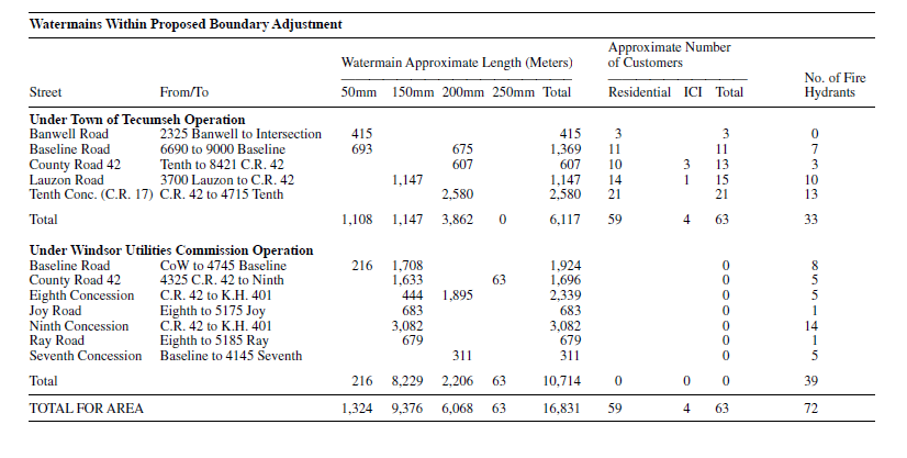
Order Made Under The Municipal Act R.S.O 1990, c.M.45
County Of Grey City Of Owen Sound, Township Of Georgian Bluffs
Definitions
-
In this Order,
“annexed area” means the area comprised of the lands described in the Schedule A to this Order;
“City” means The Corporation of the City of Owen Sound; and
“Township” means The Corporation of the Township of Georgian Bluffs.
Annexation
-
- On January 1, 2003, the portion of The Corporation of the Town- ship of Georgian Bluffs described in Schedule A is annexed to The Corporation of the City of Owen Sound.
- All real property including any highway, street fixture, waterline, easement and restrictive covenant running with the land of the hip located in the annexed area vests in the City on January 1, 2003.
Assessment
- For the purposes of the assessment roll to be prepared for the City for the 2003 taxation year, the annexed area shall be deemed to be part of the City and the annexed area shall be assessed on the same basis that the assessment roll for the City is prepared.
Taxes, etc.
-
- All real property taxes under any general or special Act levied and uncollected in the annexed area which are due and unpaid on December 31, 2002, shall be deemed on January 1, 2003, to be taxes, charges and rates due and payable to the City and may be collected by the City.
- Prior to March 1, 2003, the clerk of the Township shall prepare and furnish to the clerk of the City a special collector’s roll showing all arrears of real property taxes or special rates assessed against the land in the annexed area up to and including December 31, 2002, and the persons assessed for them.
- On the first day of the month following the month in which the real property taxes or special rates are collected under subsection (1), the City shall pay to the Township an amount equal to the amount of the real property taxes or special rates collected by the City.
- procedures under the Municipal Tax Sales Act for the annexed area and the procedures are not completed by January 1, 2003 City may continue the procedures.
By-Laws
-
- On January 1, 2003, the by-laws of the City extend to the annexed area and the by-laws of the Township cease to apply to such area except,
- by-laws of the Township,
- that were passed under section 34 or 41 of the Planning Act or predecessor of those sections; and
- that were passed under the Highway Traffic Act or the Municipal Act that regulate the use of highways by vehicles and pedestrians and that regulate the encroachment or projection of buildings or any portion thereof upon or over highways,
which shall remain in force until repealed by the council of the City;
- by-laws of the Township passed under section 45, 58, or 61 of the Drainage Act or a predecessor of these sections; and
- by-laws conferring rights, privileges, franchises, immunities or exemptions that could not have been lawfully repealed by the council of the Township.
- by-laws of the Township,
- The official plan of the County of Grey, as it applies to the annexed area and approved under the Planning Act or a predecessor of that Act, becomes the official plan of the City and shall remain in force until amended or repealed.
- If the Township has commenced procedures to enact a by-law under any Act or to adopt an official plan or an amendment thereto under the Planning Act, and that by-law, official plan or amendment applies to the annexed area in the Schedule and is not in force on January 1, 2003, the council of the City may continue the procedures to enact the by-law or adopt the official plan or amendment to the extent that it applies to the annexed area.
- On January 1, 2003, the by-laws of the City extend to the annexed area and the by-laws of the Township cease to apply to such area except,
Dated on this 25th day of November, 2002.
Chris Hodgson
Minister of Municipal Affairs and Housing
Schedule A
Description of the Lands to be Annexed
Lands in the former Corporation of the Township of Derby, now in The Corporation of the Township of Georgian Bluffs, being composed of all of Lot 74, Registered Plan 828.
Order Made Under The Municipal Act R.S.O 1990, c.M.45
City Of Bellevile City Of Quinte West
Order to Implement Amended Restructuring Proposal
This is an Order of the Minister of Municipal Affairs and Housing made pursuant to subsection 25.2(4.1) of the Municipal Act implementing a restructuring proposal that amends the restructuring proposal that was implemented by the Minister by an Order dated December 22, 1999, and published in the Ontario Gazette on January 8, 2000,
- Subsection 2(2) is amended by striking out “January 1, 2004” and substituting “January 1, 2003”.
- Subsection 4(2) is amended by striking out “January 1, 2004” and substituting “January 1, 2003”.
- Subsection 5(2) is amended by striking out “January 1, 2004” and substituting “January 1, 2003”.
- Subsection 6(4) is amended by striking out “December 31, 2003” and substituting “December 31, 2002”.
- Clause 7(1)(b) is repealed and the following substituted:
- the sum of 1,938,122 million dollars on or before January 1, 2003.
- Subsections 8(2), (4) and (5) are amended by striking out “January 1, 2004” wherever it occurs and substituting “January 1, 2003”.
- Subsection 9(2) is amended by striking out “2004” and substituting “2003”.
- Schedule “B” (Phase Two Lands) is amended by striking out “January 1, 2004” and substituting “January 1, 2003”.
Dated at Toronto on November 27th, 2002.
Chris Hodgson
Minister of Municipal Affairs and Housing