Technical guidance document for hydrogeological studies in support of category 3 applications
This document provides guidance to consultants for completing hydrogeological studies for category 3 Permit to Take Water applications. The document outlines information that is required to be provided in order for a technical review of the Permit to be completed.
Part A - Introductory Statements and Key Considerations
Purpose of this Document
This document provides guidance and a consistent, structured approach for a hydrogeological study in support of category 3 Permit to Take Water (PTTW) applications (or for Category 2 applications, where applicable). The document also aims to expedite the approval process of the PTTW application by providing ministry staff with sufficient information up front that is normally required to complete a technical review. The information provided herein is not intended to be used to replace professional judgment.
This Guidance Document does not address all aspects of the Permit to Take Water program. The reader should ensure that this document is read and used within the context of information provided by the following documents (references provided in Appendix 1):
- Ontario Water Resources Act
- Ontario Regulation 387/04. "Water Taking Regulation"
- Permit to Take Water (PTTW) Manual
- Guide To Permit to Take Water Application Form
- Water Management Policies Guidelines and Provincial Water Quality Objectives (the "Blue Book")
Purpose of Category 3 Hydrogeological Study
Applications for PTTW are classified within Category 3 based on risk management criteria. These criteria are intended to identify proposals which have a greater potential risk to existing water users or to the natural functions of the ecosystem. Applications in this category must be accompanied by a hydrogeological study that evaluates the potential for unacceptable impacts to occur as a result of the water taking. Therefore, the purpose of the hydrogeological study is to evaluate whether the proposed taking is likely to result in unacceptable impacts. The ministry will not issue a PTTW until it is satisfied that the proposed taking is unlikely to result in unacceptable impacts. The study must also propose contingency and mitigative measures that will be implemented in the event that unforeseen unacceptable impacts occur.
Key Considerations for this Document
The principles and policies of the PTTW program are outlined in the documents listed above. As an aid to the reader, a number of Key Considerations that should be addressed during the design of the taking and during the completion of a hydrogeological study are included below. Most of these Key Considerations are identified in the documents above, though some represent working interpretations of existing policies and principles. Some of these principles and policies are subject to interpretation by the ministry and therefore, pre-consultation is strongly encouraged. A successfully completed hydrogeological study will demonstrate that all of the following key considerations (if applicable) have been taken into account.
Scope of the Study
Hydrogeological studies must be prepared by a Qualified Person (QP). For the purposes of this document, a QP is a licensed Professional Geoscientist or exempted Professional Engineer as set out in the Professional Geoscientists Act of Ontario. The QP must sign and stamp a completed report which is submitted to the ministry, and shall take professional responsibility for its content and the accuracy of the information contained therein. For issues of professionalism and data integrity, the QP is directed to guidelines and codes of ethics maintained by the Association of Professional Geoscientists of Ontario (APGO) or the Professional Engineers of Ontario (PEO).
The study area that should be considered by the QP should normally encompass the land surface area covering the largest possible area of influence that could result from the proposed taking. This may include potential influences to water level, flow direction and water quality.
The level of detail required in the hydrogeological study is normally expected to be commensurate with the level of risk posed by the taking, and level of uncertainty of the available information. In their report, the QP should provide clear rationale for the level of work performed and the methodology or study approach utilized. For example:
- Where there is a lower risk of unacceptable impacts, a QP may be able to complete their report by applying hydrogeological principles to existing information, such as in the form of a desk-top study.
- Where there is a higher risk of unacceptable impacts, a QP will normally be expected to undertake field work to reduce the uncertainty associated with their assessment of the potential risks. Additional data should be collected if the Qualified Person can not confidently evaluate the risk of interference based on existing, available data.
- When the QP cannot conclusively determine that unacceptable impacts to surface water features will not occur, an appropriate QP for surface water studies will need to be consulted. The requirements for a QP for a surface water evaluation are outlined in the companion document for surface water applications.
- The ministry recognizes that there are limitations to any predictive assessment of future impact. This is particularly true for large, continuous water takings. In such cases, adaptive management plans may be an acceptable means of addressing the uncertainties.
Impacts of the Taking
A water taking may result in some degree of impact to an established water use or to the natural function of the ecosystem. This is also called interference. An unacceptable impact is normally considered to occur when an impact prevents an established water user from continuing their established pattern of use, or when an impact hinders the ability of the water resource to support existing natural functions of the ecosystem. This is also called unacceptable interference.
Water takings may not cause unacceptable impacts with an established pattern of water use. This includes water takings for which a PTTW is required and any uses for which a PTTW is not required.
Where an unacceptable impact is predicted or observed to occur, the ministry will only issue a Permit if the applicant first takes reasonable actions to restore or modify the existing user’s water supply system so that they may continue with their established pattern of water use.
Where a new taking causes a loss of free-flowing, artesian conditions in an existing well, the ministry will not consider this to be an unacceptable impact, if the existing user can restore their established use by the installation of pumping equipment.
Water takings may not cause unacceptable impacts to the natural functions of the ecosystem. This includes, but is not necessarily limited to, any function of the aquifer to provide baseflow to streams, maintain water levels in wetlands or lakes, or provide recharge to other aquifers.
Water takings may not cause irreversible impacts to the aquifer such as those that may occur if a confined aquifer is over-pumped. In addition, the taking of ground water should not normally result in the deterioration of quality on a neighbouring property.
Even if the hydrogeological study demonstrates that there will not be any unacceptable impacts, the report must propose contingency and mitigative measures that will be implemented in the event of unforeseen unacceptable impacts.
Fate of Direct Discharge Water
Wherever practical, the ministry encourages that water directly discharged from an operation be returned to its source in order to conserve ground water resources (this would not apply in takings for pumping tests or some dewatering operations, but would apply in ground-source heat-exchange systems). A direct discharge is normally considered to occur where water is returned to the environment from a point source.
The study must address the physical impacts to the natural environment that may result from a direct discharge (e.g. erosion and sedimentation).
The study may need to address water quality impacts to the natural environment that may result from a direct discharge. Water quality impacts may be regulated by Section 53 OWRA approval. The applicant should consult with the Environmental Assessment and Approvals Branch to determine if an approval is required.
In cases where essentially all of the water taken is directly returned to the source, it may be possible to base the evaluation of impacts resulting from the taking on the net taking of water from a source. Careful consideration must be given to the timing and location of the return of water to its source and the accuracy of the method used to determine the net taking. The discharge of water to the natural environment may also be regulated by a s. 53 approval. Pre-submission consultation with Regional staff is strongly encouraged.
Technical Pre-Submission Consultation
This Technical Guidance Document is intended to provide sufficient direction to enable a qualified person to undertake a detailed hydrogeological study that will address ministry requirements in most cases. Regional Staff will be able to provide additional guidance with respect to procedural or technical issues. Technical pre-submission consultation meetings with MOE Regional Qualified Persons is encouraged and can be held via telephone or in person to ensure, that among other things, the following are addressed:
- Questions regarding Ontario’s PTTW Manual, operational practices and legislative requirements are answered.
- Questions regarding the Hydrogeological Technical Guidance Document are answered and MOE Surface water staff are consulted if appropriate.
- Standard conditions for monitoring, reporting, and mitigation are discussed.
- The proponent is referred to Environmental Assessment and Approvals Branch where separate approvals for water works or discharge of waste water may be required under the Ontario Water Resources Act or the Safe Drinking Water Act.
- Conceptual acceptance regarding the type of mitigative measures being considered (if potential impacts have already been identified at this stage).
- The ministry may bring to the proponents' attention any cumulative impact or contamination concerns of which they are aware in the study area.
- Relevant MOE data and information sources have been identified.
Pre-submission consultation is not a forum to review permit classifications and is not a document review. MOE concurrence with a study approach does not guarantee that the study will lead to permit approval. For the purpose of clarification of report findings, details of proposed monitoring programs, contingency plans, etc., consultation with the ministry is not restricted to the pre-submission stage, but may be undertaken post-submission. In some cases, the ministry may not be able to disclose information due to requirements of the Freedom of Information and Protection of Individual Privacy Act.
In addition to discussions with the Ministry, pre-submission consultation may be necessary with one or more other agencies. Where appropriate, the applicant is expected to consult with external agencies prior to submitting an application for a Permit to Take Water. Consultation is necessary to identify any other necessary approvals or prohibitions that may limit the Ministry’s ability to issue a Permit. To expedite the Ministry’s technical review, the applicant is expected to provide documentation of any external consultations. The applicant may need to consult with organizations such as the local municipality, conservation authority, Niagara Escarpment Commission, or, once implemented, local Source Water Protection agencies.
Schematic of preparation of typical hydrogeologic study
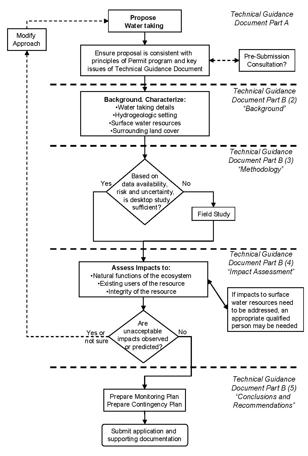
Schematic outline
- Propose water taking
- Ensure proposal is consistent with principles of permit program and key issues of technical guidance document; at this time technical pre-submission consultation meetings with MOECC regional staff are encouraged.
- Prepare the background for the study; including a characterization of the study area and a description of the water taking, hyrdogeologic setting, surface water resources and surrounding land cover.
- Based on data availability, risk and uncertainty if a desktop study is not sufficient conduct a field study.
- If the desktop study is sufficient or once the field study is complete; assess the impacts to the natural functions of the ecosystem, existing users of the resource and the integrity of the resource.
- If impacts to surface water resources need to be addressed, an appropriate qualified person may be needed.
- If unacceptable impacts are observed or predicted the approach must be modified and a new water taking will have to be proposed (return to step 1).
- If no unacceptable impacts are observed or predicted; prepare a monitoring plan and a contingency plan.
- Submit application and supporting documentation.
Recommended Report Structure
The following structure is suggested as a standard format for the hydrogeological study report. Depending on the characteristics of a proposed taking, some sections may not be necessary, while additional sections may be required.
Report Outline
The suggested report format and main section headings are as follows:
- Introduction
- Background
- Description of Taking
- Characterization of the Hydrogeological Setting
- Key Figures, Tables and Graphs
- Quaternary and Bedrock Geology
- Physical Hydrogeology
- Well Survey
- Local Surface Water Features
- Other Background Information
- Methodology
- Pumping Test & Drawdown Analysis
- Water Quality Monitoring (if applicable)
- Additional Analysis (if applicable)
- Impact Assessment
- Impact to Existing Ground Water Users
- Impact to Surface Water (if applicable)
- Other Potential Impact Considerations
- Conclusions and Recommendations
- Summary of Results and Impact Assessment
- Recommended Monitoring Program
- Recommended Contingency Plan
(Note: Omit those sections that are not relevant to your application.)
Part B - Document Structure and Content
Provided below are more detailed explanations of what should be included within each section of the hydrogeological report.
Introduction
The "Introduction" section should identify and briefly describe the general location and ownership of the property and intended use of the proposed water taking, who performed the hydrogeological study, when it was conducted and outline the scope of work performed. The purpose, rates, volume, location and predicted impact of the proposed water taking should also be summarized. The surrounding land uses and natural features located adjacent to, and/or near the property should also be provided.
Background
Description of Taking
- Outline the purpose, and justify the requested rates and volume of the proposed taking.
- Confirm that the water is required within the life of the Permit and is not being reserved for future uses other than documented planned municipal water supply purposes. It is not the purpose of the PTTW system to reserve water resources for unspecified or speculative land uses that are not likely to be approved in the immediate future.
- Briefly describe the water source, the water taking mechanism and the likely taking schedule. For example, "A high volume suction pump will empty the quarry sump which collects water from the bedrock aquifer and from surface runoff. The sump will normally be pumped for 6-8 hours/day for 4 days/week. During wet periods, we might pump for up to 24 hours/day for 4 days per week".
- Describe the locations of all proposed takings, specify the capacity of equipment that will take the water and explain any variability in taking rates and durations.
- Describe the quantity and quality of any water discharged back into the environment (see section 3b). If there is an existing approved discharge, specify the CofA number.
- If the water is from a well, include the following:
- Water well record or detailed well log showing wellhead completion (and date, if known);
- Assessment of production records and any existing water quality data;
- History of any well interference or other concerns;
- Maximum instantaneous pumping rate;
- Maximum 30 day pumping rate and volume expressed as a daily average;
- Average and maximum number of days per year of water taking.
- If the ground water taking is not from a well, include the dimensions of the source, the method (and date, if known) of construction, geologic structure, and any alterations made to the source.
Characterization of the Hydrogeologic Setting
The purpose of this section of the study report is to characterize local physiographic and hydrogeological setting, including ground water and surface water features and functions so that the potential for interference can be evaluated. This section usually includes a brief description of the local physiographic features and characterization of the relevant hydrostratigraphic units, including a determination of the ground water flow direction and may include characterizing local ground water quality.
The study area should not be limited to the property boundary, but should focus on the area delineated by the maximum predicted area of influence. An iterative approach is often needed for defining the study area; the type of information needed to estimate the area of influence is usually gained through aquifer testing. The study area should be broad enough to consider local ground water flow conditions (including local flow boundaries, constant head boundaries and aquifer boundaries) that may be relevant to the assessment of interference.
It is strongly recommended that the APGO Professional Practices Guidelines for Ground Water Resources be followed. These guidelines require field sampling and measurement to establish and confirm the Hydrogeologic characterization both spatially and temporally.
Key Figures, Tables and Graphs
As a minimum, each report should include:
- A 1:50,000 site location map that illustrates a regional overview (coloured map strongly preferred; although a clearly marked, high quality black and white/grayscale map may be acceptable).
- A study area plan drawn to scale which illustrates all significant site features, as is practical, including all on-site wells, buildings, property boundaries, all identified wells within the study area (with corresponding MOE Water Well Record identifier (WWR ID, when present)), permitted water takings, watercourses, and drainage features within the study area.
- Pumping test data, graphs, and a summary of the pumping test data and analysis. In some cases, the ministry may request that data be submitted in electronic format, preferably in a common spreadsheet format (e.g. Excel, Quattro Pro).
- Hydrogeological cross-sections with geology, borehole locations and water level measurements.
- MOE water well records (with WWR ID Numbers) or borehole logs with accurate geological descriptions.
- Table of hydrostratigraphic units and their properties.
Quaternary and Bedrock Geology
A site-specific conceptual hydrogeological model should be developed based on published geological and hydrogeological mapping, supplemented with site-specific hydrogeological information. Wherever possible, this should be done within the context of existing regional scale watershed studies or ground water studies, which commonly include pertinent information such as local recharge rates and surface water base flows. Show key topographic / geological features and describe, to an appropriate level of detail; soil materials, including thicknesses, composition, and texture. The geological stratigraphic framework should be described. In addition, in bedrock environments, known fractures, joints, bedding planes, faults, and shear zones should, where applicable, be described.
Physical Hydrogeology
Define key hydrogeological features of local aquitards and aquifers (confined, semi-confined and unconfined) that the Qualified Person considers relevant to the proposed taking. This may include details of their depth, thickness, lateral continuity, porosity, vertical/horizontal hydraulic gradients, hydraulic conductivity, transmissivity, storativity/specific storage and the location / nature of aquifer recharge supplying the well. Where available, historical/seasonal ground water level trends should be identified and interpretations of pumping tests provided.
Well Survey
The purpose of the well survey is to collect baseline data that can help prevent and resolve interference complaints. At this stage of the study, the focus is on gathering current information about the existing hydrogeological conditions. Enhanced monitoring of wells may be performed during a pumping test (see section 3), where the focus would be on impacts that occur as a result of water taking. The following information should be collected and included in the study report:
- Obtain a copy of the ministry’s water well records, or tabulated well record data (in areas with a relatively large number of wells) for all wells located within the study area.
- Reasonable effort should be made to field verify the type, location (NAD83 datum UTM coordinates), and characteristics of all registered and unregistered wells within the study area or 500 m of the pumping well (whichever is less). Beyond 500 m, drilled wells in areas predicted to experience more than 1 m of drawdown should be identified and dug or bored wells should be identified if they may have more than 0.25 meters drawdown. (these numbers provide a practical limit to the required level of effort where the zone of influence is predicted to extend for a considerable distance). Reasonable effort is normally considered to include at least one attempt to interview the owner or occupant during normal business hours and at least one repeat visit during evening hours to those locations where there was no initial response. If contact cannot be made, a note should be left in a mailbox with a contact name and telephone number.
- Where there are a relatively large number of existing wells, a representative subset of wells can be assessed if the qualified person clearly identifies the criteria used to select the wells and that all wells at higher risk of experiencing unacceptable interference are included. At a minimum, reasonable effort should be made to obtain static water level readings in the wells closest to the production well that are screened in the same aquifer.
- Where a record for a well exists but the well is buried or cannot be found, the well may be assumed to be located at the center of the front yard of the subject property.
- Where owners or occupants are unreachable, deny access or later refuse to cooperate with either the survey or monitoring, that inability to make contact or refusal should be documented by the Qualified Person. Confidentiality issues of private land owners and local residents should be respected. No individuals should be named in the reports, but should be referred to by referenced numbers (water well record numbers, if available) and locations. All private information should remain in the Qualified Person’s project files to be provided to the ministry upon request.
Local Surface Water Features
The purpose of this part of the study is to describe all surface water features in the study area so that potential interference can be evaluated. A brief description of the surface water system should be provided. All surface water features (including streams, ponds, lakes and wetlands) within the study area should be identified using Ontario Base Maps of 1:10,000 scale in southern Ontario and 1:20,000 scale, or better, in northern Ontario. If this scale of mapping is unavailable, 1:50,000 scale maps may be used. This should be supplemented with air photo interpretation wherever necessary. For more detail, please see MOE Surface Water Permit to Take Water Guidance Document.
Other Background Information
The purpose of this part of the study is to describe nearby known existing water takings (both permitted and large non-permitted takings). Local land uses which may be impacted by new or expanded water takings should also be briefly described.
Methodology
The purpose of this section is to document, describe and justify the selection of the methods used to evaluate potential interference that could be caused by the taking.
Drawdown Analysis
Where the ground water taking is from a well, a pumping test is normally required for each pumping well in the PTTW application (see Appendix 1). The results of a pumping test at one well may be applied to other nearby wells provided the Qualified Person can confidently demonstrate that the hydrogeology at the other wells is comparable. However, if the Permit Holder is applying to use more than one well simultaneously during the term of the Permit, test data approximating the aggregate maximum pumping should be provided. To obtain this test data, simultaneous pumping of the wells in order to determine the cumulative effects of the proposed taking on local water resources may be required. All water levels should be referenced to a surveyed common datum, preferably mean sea level. A description of how discharge water was managed during the pumping test should also be provided.
Water Quality
According to the Water Taking and Transfer Regulation -O. Reg. 387/04 - 4(2)(1)(ii), potential impacts of water takings on water quality should be considered. Although it is not required, it is considered good practice to conduct a baseline water quality study. This may help to determine if the water quality is suitable for the long-term intended use of the water taking, and to provide baseline data for comparison in the event of future negative impacts to water quality that may arise from other contaminant sources. Water quality study considerations are provided in Appendix 2.
Additional Analysis
This section should describe any other field studies and any numerical computer modeling conducted, and summarize any water budgets or estimates of sustainable yield that are made.
Please note that numerical computer ground water modeling is not normally required in order to obtain approval of a PTTW application. Where sufficient data are not available, modeling results must not be solely relied upon. However, if the Qualified Person decides to use numerical computer models to assist in estimating long-term ground water flow impacts, some general guidance on key components of ground water modeling that should be described in the report is provided below.
- Modeling software details - i.e., name, version, vendor, and type of hydrogeological systems for which it is designed;
- Justification of analyzing steady-state vs. transient conditions;
- Justification of hydrogeological conceptualization used to develop the model with support of real field data;
- Justification of initial and boundary conditions with support of field data;
- Discussion and justification of any assumptions made to develop the model;
- Rationale for hydrostratigraphic property selection and distribution with support of field data;
- Number, resolution, and extent of model layers;
- Model calibration;
- Model validation;
- Sensitivity analysis;
- Uncertainty (error) estimates for all calculations and predictions;
- Discussion and conclusion (conceptual model understanding, data quality assessment, model parameter sensitivity output interpretation and potential range of uncertainty for the predictions provided).
There are many modeling methods available that may be used that best suit the site-specific problem. To provide some guidance on basic procedures or considerations commonly used in ground water modeling, a number of the standards of the American Society for Testing and Materials (ASTM) are listed in the Reference section as a suggested resource. These standards are for information purposes and are not intended to be prescribed or to exclude other available and more applicable methods.
All of the above items should be accompanied with graphical presentation of the results. In addition, the model input and output may be submitted in digital format (CD/DVD) along with reports that contain a computer modeling component. Note that the level of effort required to obtain adequate data to support a model that provides useful results is often very substantial. The ministry generally considers that this level of effort is warranted only for more complex situations.
Impact Assessment
The purpose of this section is to determine whether the taking will cause unacceptable water quantity or quality interference including any of the following:
- Interference with existing ground water users;
- Impacts to natural functions of the ecosystem (including, but not limited to, reductions in stream flow and surface water availability, including effects on aquatic habitats);
- Other interference such as land stability and subsidence (including but not limited to sinkhole development) caused by lowering the water table, uncontrolled artesian flow, or discharge of water from the taking.
Assessments of potential interference should be based on the maximum possible area of influence calculated using conservative assumptions and input data or based on actual field data obtained from aquifer testing. In addition to pumping test data, aquifer characterization should consider chemical data, field-verified survey data and other hydrogeological data. Uncertainty regarding the Transmissivity (T) and Storativity Coefficient (S) / Specific Yield (Sy) values caused by variable fracture permeability, limited aquifer extent, etc., where relevant, should be discussed.
Note that it is the permit applicant’s responsibility to ensure that the quantity and quality of water that is taken is suitable for its long-term intended use. The PTTW approval process does not consider the suitability of the quantity or quality of the raw water for the intended use nor does it assess water treatment needs.
Impact to Existing Ground Water Uses
Assessment of potential impacts with existing ground water uses will typically include the following steps:
Step 1: Identify Existing Users and Potential Water Quality Concerns. Use the well survey to identify existing ground water uses within the area of influence. Based on any publicly accessible database or other sources that may be provided by the ministry or other information available to the Qualified Person, identify potential contaminant sources or naturally-occurring sources of poor water quality within the area of influence.
Step 2: Assess Interference Potential. Assess interference potential for representative ground water users within the area of influence. Potential well interference effects may be evaluated using distance/time drawdown graphs based on aquifer parameter values determined from pumping tests or determined from other information available to the Qualified Person. Predicted drawdown in wells, ponds and excavations not connected to surface water should be compared to the:
- available head (depth of water above the top of the aquifer or the completion interval, whichever is less);
- pump intake depth in area wells (based on MOE well records and well survey); and,
- depth and pumping level of local ponds (where used for water supply).
Step 3: Take Action to Avoid Unacceptable Interference: Evaluate whether measures should be taken to avoid unacceptable interference with existing users. Unacceptable interference usually means that the new water taking results in existing water users within the same hydrostratigraphic unit(s) being unable to maintain their established pattern of water use.
If there is a potential for unacceptable interference, these impacts should be quantitatively assessed using direct field measurements, such as water level measurements, during the pumping test.
Additional quantitative predictions may be made with numerical ground water models (such as Modflow or FEFlow). Larger withdrawals, such as municipal well fields, are more likely to warrant the use of numerical ground water models. If ground water models are used, the modeling process should be documented in the report, as indicated previously in section 3(c).
Impact to Surface Water and Natural Functions of the Ecosystem
If surface water bodies have been identified within the predicted maximum area of influence of the ground water taking, then potential impacts to surface water and their related natural functions of the ecosystem need to be considered. A reasonable effort should also be made to conduct field verification of all surface water bodies within the study area, with a greater focus in areas that are more likely to be impacted by the proposed water taking.
The assessment of impacts to surface water features should not necessarily be limited to the prediction of losses of stream baseflow. Even when changes to stream discharge are small, the loss of ground water discharge to the stream ecosystem may impact aquatic ecosystems. Ground water discharge may be isolated to selected reaches of a stream. Other potential impacts due the loss of ground water input include: thermal impacts and changes in water quality. These factors may be as important as reductions to stream discharge and may need to be considered. The studies also need to consider the timing of ground water taking in relation to the corresponding ecological conditions in the aquatic ecosystem. Assessment of potential impacts to natural functions of the ecosystem may be completed using the following process:
Step 1: Evaluate System Isolation. Consider whether identified surface water features are isolated from the aquifer from which water will be taken. For example, if the aquifer is deep and confined, it is unlikely that pumping water from the aquifer will have measurable impacts on the identified surface water features. System isolation needs to be assessed in the context of the magnitude of the water taking. Large, on-going takings have greater potential to induce unacceptable amounts of leakage through an aquitard compared to small and intermittent takings. If system isolation can be demonstrated, then there is no need to proceed with step 2.
Step 2: Assess Potential Impacts to Surface Water. Predict how the proposed ground water taking may change ground water flux into the surface water features within the study area. To reduce the uncertainty commonly associated with ground water-surface water interactions, the use of tracer tests, isotope analysis or installation and monitoring of steam bed mini-piezometers and/or near-shore piezometers during pumping tests is encouraged.
The following set of guidelines may be used to help the Qualified Person assess potential risks to natural functions of the ecosystem. Where more than one method is applicable, the Qualified Person is encouraged to use the most conservative method. Further surface water field studies are likely required where:
- ground water flux to any surface water feature is predicted to decrease by more than 10% in the zone of influence or 50,000 litres/day, whichever is greater; or
- the maximum predicted reduction of ground water discharge to any 1st or 2nd order river/stream is less than 50,000 litres/day but may exceed 10% of flow at any time (based on conservative calculations or on direct measurements during the taking); or
- the maximum predicted amount of stream depletion in a 3rd or higher order river/stream is greater than 5% of 7Q20. In this case, a surface water qualified person would need to perform the equivalent of a Category 2 submission for PTTW; or
- ground water is discharging into a known fish spawning area.
The values discussed above are not intended to be prescribed standards, but are only intended to indicate that such changes in ground water flux are generally considered to pose a low risk of causing negative impacts to the natural functions of the ecosystem. Furthermore, exceedence of these limits does not immediately signify a need to contract a surface water hydrologist or aquatic ecologist/biologist, but rather may indicate that additional investigations are required to provide more accurate and reliable data. (Note: 10% is usually within the range of error and uncertainty for ground water measurements. As a result, it is not possible to economically and reasonably measure changes in surface water flow/levels below this amount and to attribute these changes to the ground water taking.)
If the proposed taking is predicted to stay approximately within the limits outlined above within a reasonable degree of uncertainty, and there is an insignificant risk of unacceptable impacts to the natural functions of the ecosystem in the connected water bodies, then there is no need to proceed to Step 3.
Step 3: Hydro-ecological Study. Where the study indicates that the proposed taking may cause significant changes in the amount of ground water flowing between the hydrostratigraphic unit and connected surface water, more detailed field studies performed by Qualified Person(s) with expertise in surface water hydrology and aquatic ecology or biology may be required. The ministry’s Technical Guidance document for Category 3 Surface Water Takings may serve as a reference to evaluate and assess potential impacts to surface water and natural functions of the ecosystem.
Other Potential Impact Considerations
Other potential unacceptable interference effects within the maximum area of influence should be considered, including the following:
- Stability of geotechnically sensitive soils such as marine clay or peat;
- Subsidence and potential damage to structural integrity;
- Potential for uncontrolled artesian flow;
- Any other considerations not mentioned in this guidance document that the Qualified Person feels is relevant.
Conclusions and Recommendations
Summary of Results and Impact Assessment
The purpose of this section is to summarize pumping test results and/or historical monitoring data and identify any potential negative impacts on the natural environment and/or existing water uses. A clear summary statement must be provided by the Qualified Person indicating whether or not they anticipate any unacceptable interference and under what circumstances this may occur.
Proposed Monitoring Plan
The purpose of this section is to recommend an appropriate monitoring program. A ground water monitoring plan should be designed for long-term takings to:
- confirm that the taking does not result in unacceptable impacts to either the natural functions of the ecosystem or to existing water uses;
- ensure that ground water elevation levels do not fall below an unacceptable level;
- confirm over time whether there is significant deviation between actual and predicted impacts; and,
- initiate contingency action in the event that unforeseen unacceptable impacts do occur.
The contingency plan can be put into action if the monitoring results indicate that the thresholds for action have been reached. Note that in all cases daily records of water taking amounts are required of a permit holder. Additional monitoring that may be required includes measuring water levels and determining water quality changes over time (if applicable). Where impact on surface water features is possible, biological monitoring and flow monitoring may also be required. In conjunction, this section should also recommend water taking conditions that will help ensure that the proposed water taking does not result in unacceptable impacts. Monitoring plans should identify the following:
- Frequent or continuous water-level monitoring of production and observation wells using automatic digital recording is strongly encouraged. All monitoring data should be submitted in graphical and digital formats (i.e., Microsoft Excel) as part of the supporting documentation.
- The number of wells or piezometers required to effectively monitor ground water levels and quality need to be identified.
- Specific hydrostratigraphic units that are being monitored.
- Frequency and type of data collection (i.e. water levels, water quality).
- Field sampling methods.
- Methods of reporting and data analysis.
- Field and laboratory sample quality assurance and quality control procedures.
Proposed Contingency Plan
The purpose of this section is to develop contingency plans and establish trigger limits to govern when the plans are to be put into action. Contingency plans should contain a description of mitigative measures that will be taken in the event that unforeseen and unacceptable impacts occur as a result of the proposed taking. Contingency plans should include the following:
- Incorporation of low water response plans (where applicable).
- Description of mitigative measures to minimize or restore any negative impacts that may occur (this may include plans to reduce and/or cease water taking activities, temporary and permanent water supply restoration measures to affected parties, etc.).
- A trigger mechanism which specifies the circumstance(s) that will trigger the implementation of the contingency plan.
- Continued monitoring after pumping activity is reduced or ceased to assess recovery of static water levels.
In many cases a simple contingency plan is appropriate. For example, when a complaint is received or the ministry determines that unacceptable interference is occurring, the water taking could be stopped until the problem is rectified. In cases where stopping the water taking has unacceptable impacts to the permit holder, a more elaborate contingency plan may be needed.
Part C - References and Appendices
References and Suggested Resources
Association of Professional Geoscientists of Ontario. General Professional Practice Guidelines for Environmental Geoscience (Online). September 2003.
ASTM D 5447-04, "Standard Guide for Application of a Ground-Water Flow Model to a Site-Specific Problem", ASTM International.
ASTM D 5490-93(2002), "Standard Guide for Comparing Ground-Water Flow Model Simulations to Site-Specific Information", ASTM International.
ASTM D 5609-94(2002), "Standard Guide for Defining Boundary Conditions in Ground-Water Flow Modeling", ASTM International.
ASTM D 5610-94 (Re-approved 2002), "Standard Guide for Defining Initial Conditions in Ground-Water Flow Modeling", American Society for Testing and Materials (ASTM) International.
ASTM D 5611-94(2002), "Standard Guide for Conducting a Sensitivity Analysis for a Ground-Water Flow Model Application", ASTM International.
ASTM D 5718-95(2000), "Standard Guide for Documenting a Ground-Water Flow Model Application", ASTM International.
ASTM D 5730-04, "Standard Guide for Site Characterization for Environmental Purposes with Emphasis on Soil, Rock, the Vadose Zone and Groundwater", ASTM International.
ASTM D 5880-95(2000), "Standard Guide for Subsurface Flow and Transport Modeling", ASTM International.
ASTM D 5979-96(2002), "Standard Guide for Conceptualization and Characterization of Ground-Water Systems", ASTM International.
ASTM D 5981-96(2002), "Standard Guide for Calibrating a Ground-Water Flow Model 18 Application", ASTM International.
Bear, J., Beljin, M. S., and R. R. Ross. 1992. Fundamentals of Ground-Water Modeling. EPA/540/S-92/005. Office of Solid Waste and Emergency Response, U.S. Environmental Protection Agency, Washington, D.C.
Guide to Permit to Take Water Application Form
Ontario Ministry of the Environment and Climate Change. Technical Guidance Document for Surface Water Studies In Support of Category 3 Applications for Permit to Take Water. Queen’s Printer for Ontario, March 2006. No availability. April 2005.
Ontario Ministry of the Environment and Climate Change. Water Management – Policies, Guidelines, Provincial Water Quality Objectives (Also known as the MOE's "Blue Book"). (PIBS 3303e) Queen’s Printer for Ontario, July 1994.
Ontario Ministry of the Environment. Soil, Groundwater and Sediment Standards for Use Under Part XV.1 of the Environmental Protection Act. (PIBS 4697e) Queen’s Printer for Ontario, March 9, 2004.
Professional Engineers of Ontario. Guideline – Professional Practice (Online).
Water Taking Regulation (O. Reg. 387/04)
Appendix 1: Pumping Test Design and Data Analysis
This appendix provides suggested guidance on designing pumping tests, analyzing the data and preparing the report for the purpose of evaluating the hydrogeological properties of the applicable hydrostratigraphic unit(s) and assessing potential impacts that may result from the proposed water taking. This appendix applies to pumping tests carried-out as part of category 2 and category 3 ground water Permit to Take Water studies. Note that pumping tests themselves require a PTTW.
Pumping Test Design
Pumping tests are typically required for each pumping well in the PTTW application. If more than one well will be pumped simultaneously during the life of the Permit, then all such wells should be used during the pumping test in order to more accurately determine the cumulative impacts of the combined takings. The following items should be considered when designing pumping tests:
- Duration: Testing should be carried-out until, in the opinion of a Qualified Person, the presence of relevant boundary conditions and impacts on other users and natural features has been adequately assessed. This normally takes at least 24 hours (although a 72-hour pumping test is generally recommended), but the period may be shorter if the Qualified Person is satisfied that the system has been adequately characterized (i.e., a prolonged period of stable water levels are recorded in the pumping well during the test).
- Flow Rate: An initial step drawdown test is recommended in order to determine the optimum constant rate for the continuous pumping test. Where possible, the flow rate for the pumping test should meet or exceed the rate requested on the PTTW application. In regards to multiple wells, the Qualified Person should consider whether separate tests for each individual well or simultaneous pumping tests, or some other combination, is appropriate to assess potential impacts of the proposed taking.
- Discharge: The pumping test design should ensure that the discharge of extracted water will not interfere with the pumping test results or cause serious erosion, scouring, or sediment deposition.
- Timing: The pumping test design should consider the timing of the test. For example, there may be preferred times of the year to conduct the pumping test or, conversely, there may be periods of the year that should be avoided, such as when pumping may cause unacceptable impacts with coldwater fish spawning habitat or incubation of eggs/fry.
Monitoring Requirements
- Flow Records: An accurate and properly calibrated flow metering device should be installed on the pumping well or an alternative accurate flow metering methodology should be used. Flow readings should be made as frequently as required to confirm that there are no fluctuations in the pumping rate or, when intentional changes in pumping rates are made, to confirm that the intended change has been made. Periodic manual checks on flow rate should be made to calibrate the metering device.
- Observation Wells: Observation well(s) should be sited at the best location(s) to characterize local hydrogeological conditions and to assess potential off-site interference. The ministry recognizes there may be access constraints. Observation well(s) need to be screened within the same formation as the pumping well in order to assess drawdown and additional wells may need to be screened at different depths to evaluate hydraulic connectivity between hydrostratigraphic units and surface water features.
- Water Level Measurements: Water level measurements are a critical part of every pumping test. Their collection should consider the following points:
- The pumping test should include water level measurements both during and after pumping, typically until 95% recovery occurs or until sufficient data have been collected to confidently establish the recovery curve. In many circumstances, it may be necessary to perform continuous water level measurements, especially near the beginning of the test. Continuous measurement would be considered to be at a frequency of a minute or less. This is normally accomplished using pressure transducers and data loggers or similar instrumentation, as opposed to manual measurement.
- All water levels should be measured with respect to depth below ground surface, or a fixed benchmark, such as top of casing, and referenced to elevation above mean sea level, where practical. Where a fixed benchmark is established, the height above grade should be determined, in addition to the elevation above mean sea level. All wells used for data collection should be georeferenced to NAD83 coordinates using UTM projection.
- Static water level measurements should be monitored at all available monitoring wells at least once daily, over a period of several days, prior to the start of the pumping test in order to obtain background static water level conditions.
- Whenever possible, collect water level measurements from wells on neighbouring properties before, during, and immediately after the pumping test in order to more accurately assess potential for interference.
- If available, pressure transducers with data logging capability should normally be used to record water levels at the pumping well and at least one observation well, if available. Data may be recorded on a logarithmic time cycle for short term (less than 72 hour) tests beginning at a frequency of one minute or less. For longer term testing, the measurement interval using pressure transducers should not normally increase beyond one hour.
Electronic recordings should be supplemented by periodic manual readings at select well(s) for verification. It is recommended to make manual readings at the following time intervals:
Example Elapsed Time (minutes) Manual Measurement Time Intervals (minutes) 0-10 0.5 10-15 1 15-60 5 60-120 30 120-end of test 60 Longer measurement intervals may be appropriate for tests of durations greater than 72-hours.
- Surface Water Monitoring: Potential impacts to surface water may need to be assessed through the pumping test. If the ground water taking is potentially connected to a surface water feature within the period of time that the drawdown cone might reasonably be expected to stabilize, surface water levels should be monitored before, during and after the pumping test. The assessment should include precipitation records and should specify the exact location of discharged water with respect to surface water. Shallow piezometers should be installed near local surface water to assess potential changes in hydraulic gradients towards the surface water feature, especially where these surface water features are very sensitive to any change in baseflow. Where the pumping is from a confined or semi-confined aquifer, monitoring of overlying aquitard and aquifer units may also be needed to assess the potential effect on surface water.
Pumping Test Reporting
Pumping test details that should be outlined in the report, include, but are not limited to the:
- name of the certified pump installer and the Qualified Person supervising the test;
- construction details of the pumping well(s) and observation wells (including their location, radial distance from the pumping well(s), Water Well Record identification number and construction details);
- water levels measured before and during the test in the pumping well, observation wells, potentially affected off-site wells and at surface water stations (the ministry may request that data files be submitted electronically instead of, or in addition to written tables);
- pumping test set-up details (pump size, pump depth, flow control and measurement, discharge location);
- type of test (step, constant rate, recovery);
- date and time when pumping started and ended;
- field observations (e.g. pH, conductivity, temperature);
- weather observations during tests (barometric pressure, rainfall etc.);
- pumping flow rate adjustments;
- consideration of other sources of pumping that may interfere with data interpretation and,;
- any reported cases of interference with private wells.
Pumping Test Analysis
A detailed graphical and/or analytical analysis of the pumping test and step drawdown test data should be provided in the report. This analysis should include, but is not limited to the following:
- Calculations of transmissivity and hydraulic conductivity and (where observation wells exist) storativity or specific yield.
- Identification of boundary conditions.
- Assessment of the potential drawdown at various times and selected distances from the pumping well. A map drawn to scale should show the estimated radius of influence.
- Predicted drawdown in the potentially affected neighbouring wells compared to the amount of available head and to the pump intake depth.
- The rationale for selecting a specific analytical method (including a discussion of its assumptions and limitations) should be clearly stated. Recognized methods for analyzing pumping test data include, but are not limited to, the following:
- Cooper-Jacob (1946) Straight Line Approximation (confined, unsteady state)
- Theis (1935) Curve Matching Method (confined, unsteady state, pumping or recovery)
- Neuman (1975) Curve Fitting Method (unconfined, unsteady state, delayed response)
- Hantush-Jacob (1955) Method (leaky, unsteady state, no storage in aquitards)
- Hantush (1960) Method (leaky, unsteady state, with storage in aquitards)
- Thiem (1906) Method (confined, steady state)
- Neuman and Witherspoon (1972) Method (leaky aquifers)
Examples of circumstances where a detailed evaluation of aquifer properties and boundary conditions are not warranted are:
- Where minimal drawdown occurs in the pumping well and that drawdown stabilizes during the test.
- Where an application is for discontinuous taking, the pumping test is conducted for the maximum requested daily duration and at the maximum daily amount and where all at-risk receptors are monitored during the test. In that case the monitoring data during the test provides a direct indication of the potential for interference.
Pumping Test References
Cooper, H. H. and Jacob, C. E., 1946. A generalized graphical method for evaluating formation constants and summarizing well field history: American Geophysical Union Trans., vol. 27, pp. 526-534.
Hantush, M. S., 1960. Modification of the theory of leaky aquifers: Journal of Geophysical Research, vol. 65, no. 11, pp. 3713-3725.
Hantush, M. S. and Jacob, C. E., 1955. Non-steady radial flow in an infinite leaky aquifer: American Geophysical Union Trans., vol. 36, pp. 95-100.
Neuman, S. P., 1975. Analysis of pumping test data from anisotropic unconfined aquifers considering delayed yield: Water Resources Research, vol. 11, no. 2, pp. 329-342.
Neuman, S. P. and Witherspoon, P. A., 1972. Field determination of hydraulic properties of leaky multiple-aquifer systems: Water Resources Research, vol. 8, no. 5, October 1972, pp. 1284-1298.
Thiem, G., 1906. Hydrologische Methoden. Gebhardt, Leipzig, 56 p.
Theis, C. V., 1935. The relation between the lowering of the piezometric surface and the rate and duration of discharge of a well using groundwater storage: American Geophysical Union Trans., vol. 16, pp. 519-524.
Appendix 2: Water Quality Monitoring Considerations
The following are key considerations that should be incorporated into the study:
- New water takings should not result in water quality impacts that unacceptably interfere with existing ground water uses or natural functions of the ecosystem.
- Water quality impact assessments should address the following:
Water quality impacts to a neighboring well(s) by induced mixing of water of differing quality caused by the proposed water taking activity. This may be water of naturally poor quality or water that is contaminated by human activity.
Example 1: A well screened in a bedrock aquifer over time may begin to withdraw ground water from deeper zones that may contain brine or other non-desirable natural chemicals. This may adversely impact neighbouring wells that provide domestic water supply or other water uses.
Example 2: The owner of Property A applies for a PTTW to pump ground water from a well. Property C has contaminated ground water and is located within the well’s capture zone. Property B is located in-between Properties A and C, and has a domestic water supply well within the same aquifer in question. Continuous pumping from the Property A's well may cause the contaminant plume from Property C to migrate onto Property B and may in turn cause adverse impacts to the domestic water supply well on Property B.
The Qualified Person should make a reasonable effort to determine if there are any known or potential contaminant sources within the cone of influence of the water taking site, which may negatively impact water quality induced by the water taking. This may involve a general site reconnaissance of the immediate area surrounding the site of the water taking to identify potential sources of contamination. No specific field investigation is required by the Permit applicant to address contaminant sources for which it is not responsible. If the Qualified Person deems it necessary, detailed records of specific contaminant sources from the ministry may be obtained through a Freedom of Information request.
In accordance with "Water Management Policies, Guidelines, Provincial Water Quality Objectives of the Ministry Of Environment and Energy", Section 5.1.3, all reasonable and practical measures should be taken to maximize the availability of ground water for existing or potential uses. As such, where induced contamination is identified by the Qualified Person as a significant risk, and where the source of that contamination is not the responsibility of the applicant, responsibility for addressing that impact will normally rest with the party responsible for the contamination. The Director will consider the Qualified Person’s evaluation in determining what action the responsible party must take to address the contamination.
- Physical impacts associated with discharge water (including construction dewatering). Common concerns include: flooding, erosion, and sedimentation when discharging to surface water. Water quality impacts associated with discharge water to a receiving water body may need to be addressed through a Certificate of Approval issued by the Environmental Assessment and Approvals Branch.
- Potential physical and/or ecological impacts to surface water systems resulting from losses in ground water input.
- Where the potential for an induced water quality impact on an existing water user related to naturally-occurring compounds has been identified, it is acceptable for the water taker to address that potential induced impact by incorporating a contingency plan for the provision of treatment devices or alternative water supply should the impact occur. Only a reasonable degree of effort is required to predict the likelihood of such an impact, such as, if background ground water quality information from regional studies is readily available.
- Aesthetic problems related to microbiological activity such as iron-reducing or sulphate-reducing bacterial infestations, are not within the scope of evaluation of induced water quality problems. Because these are naturally-occurring organisms and the factors involved in the creation of infestations are poorly understood, the occurrence of an infestation cannot be adequately predicted or attributed to any given cause.
- Category 3 PTTW hydrogeological studies do not need to duplicate water quality monitoring and control issues that are addressed by legal instruments. For example, water quality concerns associated with a PTTW for a ground water pump-and-treat system that discharges to surface water should be addressed in a Section 53 Certificate of Approval.
- If there is a significant risk of water quality impacts that may result from the proposed water taking, a water quality sampling program may need to be developed. Sampling frequency depends on the level of risk.
- Potential water quality impacts on ground water uses should be assessed using applicable water quality standards or guidelines based on the type of potential receptor(s). Potential impacts to drinking water supplies should assessed using the Ontario Drinking Water Quality Standards and the Ontario Drinking Water Objectives. Potential water quality impacts on natural functions of the ecosystem should be assessed using criteria from Table 4 of Ontario Regulation 153/04 for un-regulated anthropogenic contaminant sources or the relevant Provincial Water Quality Objectives for natural compounds or regulated contaminant sources.
- Any historical water quality data collected during the pumping test stage or under an existing Permit should be presented in a table comparing results with the applicable standards or guidelines. The report should include an interpretation of the water quality analysis using applicable analytical methods (such as Piper or Durov or similar plots for major ion geochemical analyses). Time-trend graphs are very helpful and should be used whenever samples have been collected over time.
- A contingency plan is required in the event of water quality impacts occurring to other existing uses or on the site itself resulting from the proposed water taking. Notification to the Regional OWRA s. 34 Director and local District Office (during regular business hours), or the Spills Action Centre (1-800-268-6060; emergencies) may be required and/or to seek further assistance.