Technical guidance document for surface water studies in support of category 3 applications
Technical guidance document for surface water studies.
Part A - Introductory Statements and Key Considerations
Purpose of this Document
This document provides guidance and a consistent, structured approach for a surface water study (hydrological and or ecological) study in support of a category 3 Permit to Take Water (PTTW) applications (or for Category 2 applications, where applicable). The document also aims to expedite the approval process of the PTTW application by providing ministry staff with sufficient information up front that is normally required to complete a technical review. The information provided herein is not intended to be used to replace professional judgment.
This Guidance Document does not address all aspects of the Permit to Take Water program. The reader should ensure that this document is read and used within the context of information provided by the following documents (on-line references provided in Part C of this document):
- Ontario Water Resources Act (OWRA)
- Ontario Regulation 387/04. "Water Taking Regulation"
- Permit to Take Water Manual
- Guide To Permit to Take Water Application Form
- Water Management Policies, Guidelines and Provincial Water Quality Objectives (the Blue Book)
Purpose of Category 3 Surface Water Study
Applications for PTTW are classified within Category 3 based on risk management criteria. These criteria are intended to identify proposals which have a greater potential risk to existing water users or to the natural functions of the ecosystem. Applications in this category must be accompanied by a surface water study that evaluates the potential for unacceptable impacts to occur as a result of the water taking. Therefore, the purpose of this study is to evaluate whether the proposed taking is likely to result in unacceptable impacts. The ministry will not issue a PTTW until it is satisfied that the proposed taking is unlikely to result in unacceptable impacts. The study must also propose contingency and mitigative measures that will be implemented in the event that unforeseen unacceptable impacts occur.
Key Considerations for this Document
The principles and policies of the PTTW program are outlined in the documents listed above. As an aid to the reader, a number of Key Considerations that should be addressed during the design of the taking and during the completion of a surface water study are included below. Most of these Key Considerations are identified in the documents above, though some represent working interpretations of existing policies and principles. Some of these principles and policies are subject to interpretation by the ministry and therefore, pre-consultation is strongly encouraged. A successfully completed surface water study will demonstrate that all of the following key considerations (if applicable) have been taken into account.
Scope of the Study
Surface water studies must be prepared by a Qualified Person (QP). For the purposes of this document, a QP is a person holding at minimum a bachelor degree with specialization in hydrology, aquatic ecology, limnology, biology, physical geography and/or water resource management or engineering. The type of scientific work that a qualified person performs must be consistent with that person’s education and experience. The QP must sign a completed report which is submitted to the ministry, and shall take professional responsibility for its content and the accuracy of the information contained therein.
QP's licensed by the Association of Professional Geoscientists of Ontario (APGO) or the Professional Engineers of Ontario (PEO) must sign and stamp a completed report which is submitted to the ministry. For issues of professionalism and data integrity, the QP is directed to guidelines and codes of ethics maintained by their respective associations. On-line references are provided in Part C of this document.
The study area that should be considered by the QP should normally encompass the land and water surface area reasonably expected to be impacted by the proposed taking. This includes for lotic (flowing) systems, areas both upstream and downstream of the water taking.
The level of detail required in the surface water study is normally expected to be commensurate with the level of risk posed by the taking, and level of uncertainty of the available information. In their report, the QP should provide clear rationale for the level of work performed and the methodology or study approach utilized. For example:
- Where there is a lower risk of unacceptable impacts, a QP may be able to complete their report may be based on existing information or secondary research, such as in the form of a desk-top study. The study must demonstrate the relevance of the existing information to the water taking in question. Some confirmatory field data collection may be necessary to validate the existing information.
- Where there a higher risk of unacceptable impacts, a QP will normally be expected to undertake field work to reduce uncertainty associated with their assessment of potential risks. The extent of the field work may be reduced if:
- the ministry considers the taking to be well-understood and the potential impacts easily mitigated; or
- the ministry has firm knowledge about the study area; or
- the QP can show that an existing study adequately addresses significant concerns and demonstrate its relevance to the specific water taking.
- If there is a reasonable uncertainty about the potential for impact to ground water, an appropriate QP for hydrogeological studies (licensed Professional Geoscientist or exempted Professional Engineer as set out in the Professional Geoscientists Act of Ontario) will need to assess such impacts. The study area may need to be adjusted to account for ground water concerns.
- The ministry recognizes that there are limitations to any predictive assessment of future impact. This is particularly true for large, continuous water takings. In such cases, adaptive management plans may be an acceptable means of addressing the uncertainties that cannot be resolved through any pre-operational study. The adaptive management approach must describe how the water taking will be adjusted in response to contingencies.
Impacts of the Taking
Every water taking results in some degree of impact to the resource, potentially also impacting an established water use or natural function of the ecosystem. This is also called interference. An unacceptable impact is normally considered to occur when an impact prevents an established water user from continuing their established pattern of use, or when an impact hinders the ability of the water resource to support existing natural functions of the ecosystem. This is also called unacceptable interference and the study must affirm that this will not occur or is unlikely to occur. Environmental impact or interference with the natural function of the surface water source will not be permitted. In an adaptive management approach, the taking will be curtailed to the extent necessary, including eliminating the taking, until such environmental impact is removed.
Where an unacceptable impact is predicted or observed to occur, the ministry will only issue a Permit if the applicant first takes reasonable actions to mitigate impacts and restore or modify the existing user’s water supply system so that they may continue with their established pattern of water use.
Existing users are expected to allow new users to take reasonable actions to maintain the existing users established pattern of use and thereby allow fair sharing of the water resource. If permission to restore or modify an existing water supply system is refused, the ministry will not normally consider subsequent impacts to the same system resulting from the taking to be unacceptable.
Even if the surface water study demonstrates that there will not be any unacceptable impacts, the report must propose contingency and mitigative measures that will be implemented in the event of unforeseen unacceptable impacts.
Fate of Direct Discharge Water
Where almost all of the water taken is directly returned to its source in the same quality, such as once-through cooling water, it may be possible to evaluate impacts based on the net taking of water. The assessment must consider the timing and location of the water return and the accuracy of the method used to determine the net taking. The impact assessment must also include the physical effects of the water intake (entrainment) and discharge (energy dissipation).
Technical Pre-Submission Consultation
This Technical Guidance Document is intended to provide sufficient direction to enable a qualified person to undertake a detailed surface water study that will address ministry requirements in most cases. Regional Staff will be able to provide additional guidance with respect to procedural or technical issues. Technical pre-submission consultation meetings with MOE Regional Qualified Persons is encouraged and can be held via telephone or in person to ensure, that among other things, the following are addressed:
- Interpretation of Ontario’s water management policies, practices and legislative requirements.
- Permit standard conditions for monitoring, reporting, and impact mitigation.
- Other environmental or resource-related approvals required and which agencies to contact for these approvals.
- Ministry local knowledge, data and information sources, especially related to cumulative impact or contamination concerns in the study area.
Pre-submission consultation is not a forum to review permit classifications and is not a document review. MOE concurrence with a study approach does not guarantee that the study will lead to permit approval. For the purpose of clarification of report findings, details of proposed monitoring programs, contingency plans, etc., consultation with the ministry is not restricted to the pre-submission stage, but may be undertaken post-submission. In some cases, the ministry may not be able to disclose information due to requirements of the Freedom of Information and Protection of Individual Privacy Act.
In addition to discussions with the Ministry, pre-submission consultation may be necessary with one or more other agencies. Where appropriate, the applicant is expected to consult with external agencies prior to submitting an application for a Permit to Take Water. Consultation is necessary to identify any other necessary approvals or prohibitions that may limit the Ministry’s ability to issue a Permit. To expedite the Ministry’s technical review, the applicant is expected to provide documentation of any external consultations. The applicant may need to consult with organizations such as the local municipality, conservation authority, Niagara Escarpment Commission, or, once implemented, local Source Water Protection agencies.
Schematic of preparation of typical surface water study
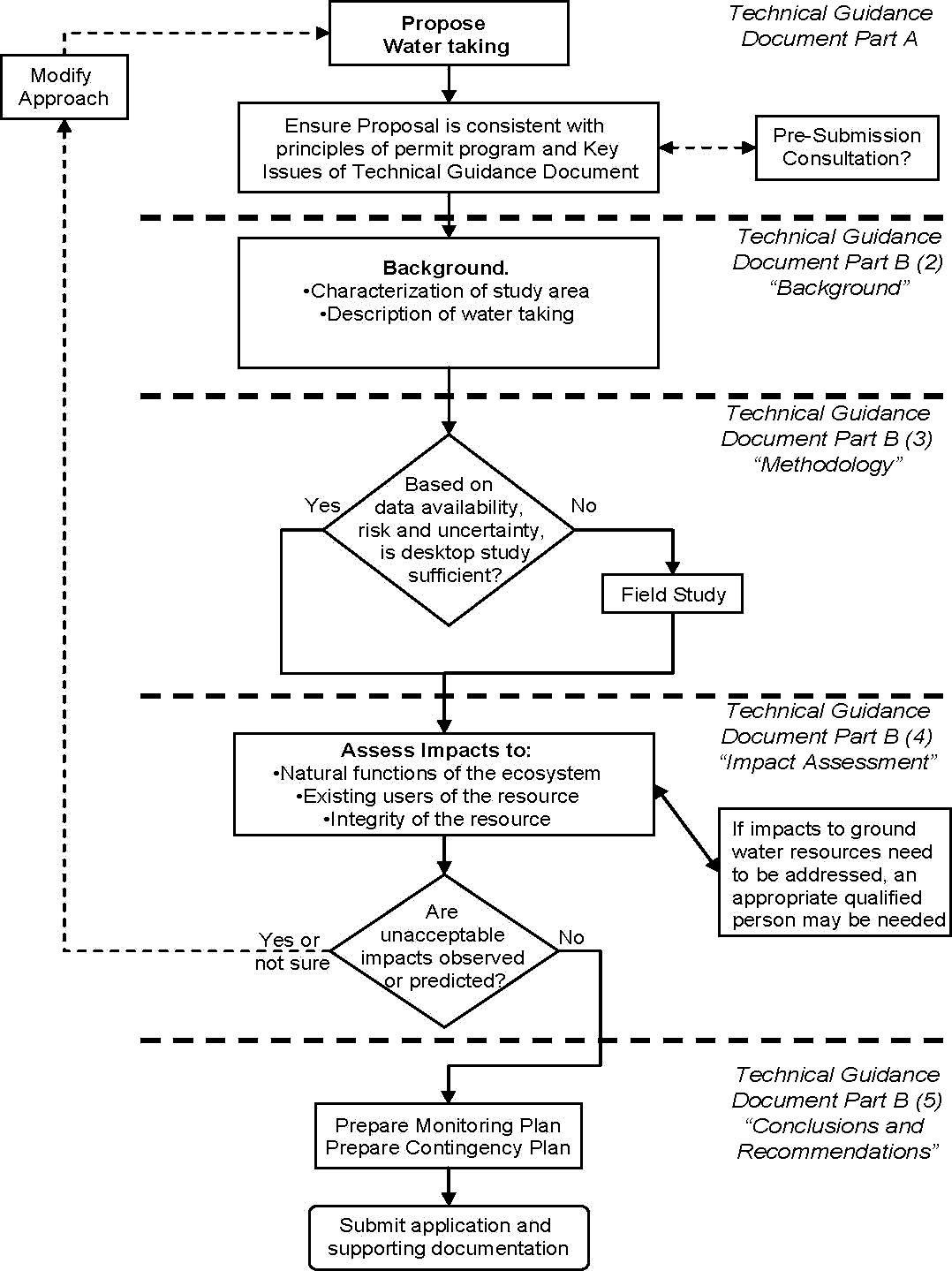
Schematic outline
- Propose water taking
- Ensure proposal is consistent with principles of permit program and key issues of technical guidance document; at this time technical pre-submission consultation meetings with MOECC regional staff are encouraged.
- Prepare the background for the study; including a characterization of the study area and a description of the water taking.
- Based on data availability, risk and uncertainty if a desktop study is not sufficient conduct a field study.
- If the desktop study is sufficient or once the field study is complete; assess the impacts to the natural functions of the ecosystem, existing users of the resource and the integrity of the resource.
- If impacts to ground water resources need to be addressed, an appropriate qualified person may be needed.
- If unacceptable impacts are observed or predicted the approach must be modified and a new water taking will have to be proposed (return to step 1).
- If no unacceptable impacts are observed or predicted; prepare a monitoring plan and a contingency plan.
- Submit application and supporting documentation.
Recommended Report Structure
The following structure is suggested as a standard format for the surface water study report. Depending on the characteristics of a proposed taking, some sections may not be necessary, while additional sections may be required.
Report Outline:
The suggested report format and main section headings are as follows:
- Introduction
- Background
- Description of Taking
- Characterization of the Study Area
- Methodology
- Streams and Rivers
- Pro-rating Flow Information
- Lakes and Ponds
- Impact Assessment
- Conclusions and Recommendations
- Proposed Monitoring Plan
- Proposed Contingency Plan
(Note: Omit those sections that are not relevant to your application.)
Part B - Document Structure and Content
Provided below are more detailed explanations of what should be included within each section of the surface water report.
Introduction
The "Introduction" section should identify and briefly describe: the organization and individuals who performed the surface water study; when it was conducted and outline the scope of work performed; the watershed by name and identify the basin and study area location including the street address (if available) and the lot, concession and geographic township; the ownership of the property and intended use of the proposed water taking; the water taking details such as rates, volume, and location; the water resource to be protected and the predicted impact of the taking; and the surrounding land uses and natural features located adjacent to, and/or near the property should also be provided.
Background
Description of Taking
A description of the taking is required for the permit application. The study report should confirm that the taking description is complete and provide any additional details or explanation which would improve the characterization of the water taking beyond the application information.
Characterization of the Study Area
In this section the physiographic, hydraulic, hydrologic and geomorphic processes of the surface water source and its current and historical natural functions are characterized so that the potential for interference can be assessed. Surface water features include swales, wetlands, intermittent or permanent streams, large rivers, drains, headwaters, lakes, ponds (on-stream, or otherwise connected to surface water) and abandoned pits.
A description of the aquatic habitat and aquatic community (benthos, fish, plants) in the nearest viable habitat upstream and downstream and the human uses of the water resource, e.g., cold water or warm water fishery, irrigation, recreation, power production should be included in this section.. Flow regimes and water levels, in the context of water availability for the taking, should be characterized.
The Ministry of Natural Resources (MNR), Conservation Authorities (CA's), and Environment Canada (Water Survey of Canada) monitor stream flow or weather/climate data. MNR's Surface Water Monitoring Centre in Peterborough collects data from stream flow and precipitation gauges weekly for the Ontario Low Water Response Program. CA's and/or MNR have fisheries and aquatic habitat information for many watersheds. These agencies may be sources of relevant information.
All surface water features including wetlands within the study area should be identified using appropriate layers on a Geographic Information System-based map, or failing GIS availability, Ontario Base Maps with a minimum scale of 1:10,000 southern Ontario and 1:20,000 northern Ontario,. Only if this scale of mapping is unavailable, may a 1:50,000 map be used. Mapping should be supplemented with air photo interpretation wherever necessary.
Information on historical and current water resource conditions, water uses, and watershed management objectives helps to define the resource to be protected. Identify, geo-locate and describe nearby existing water takings, both permitted and large non-permitted takings. Air photos, topographical maps, previous technical reports, watershed studies, water-taking permits and land use records are sources of information. At a minimum, information on the study area land use, topography, soils and other water-takings should be included in the report. Where little or no information exists for the watershed, the methods for deriving existing conditions should be rationalized.
In terms of field work, verification of surface water features should be conducted; stations should be located by GPS and stream order identified for all river systems. For a stream channel, cross-sectional measurements for width (wet and bank-full), depth, and cross-sectional velocity paneling are commonly used to characterize stream discharge or flow. Stream flow gauging is of primary importance, but a longitudinal survey of stream reach also can provide data on bed substrate, meander patterns, riffle-pool sequences and the presence of in-stream barriers (dams/weirs), diversions and outfalls. Information on stream bank condition and riparian vegetation can be used to evaluate fluctuations in water level and influences on the thermal regime. Temperature data, even spot measurements, can be useful. This information together forms the benchmark with which to assess future changes in aquatic environmental conditions.
Assess available information with respect to location, period of record, and currency to determine if the data may be helpful, for example for calibrating model simulations. Caution should be exercised in interpreting data in areas where landscape changes, such as urbanization or deforestation, are occurring rapidly because the effects of these changes may not be fully realized. Differences in field sampling techniques and flow monitoring methods should be considered when combining data sets.
Methodology
The purpose of this section is to document, describe and justify the selection of the methods used to evaluate potential interference that could be caused by the taking.
Environmental conditions vary tremendously across Ontario, so an in-stream minimum flow or water level requirement will be determined by a site-specific assessment. Each stream is unique in terms of watershed condition, channel morphology, flow pattern, and aquatic community. It is not feasible to recommend one assessment method or low flow index for all situations. While acceptable methods cannot be prescribed, some common ones are identified below.
A minimum or low flow requirement must be capable of sustaining aquatic habitat to support the growth, survival and reproduction of all stages of resident aquatic life throughout the year. Critical factors for a watercourse include water velocity, depth and temperature. A minimum instantaneous flow which sustains only the acute survival of aquatic life is not acceptable as a long-term low flow requirement.
The QP should review alternative assessment methods and select the most appropriate one (or more), with a justification that it produces a conservative assessment. It may be necessary to compare the results of several different methods as a basis to recommend a minimum flow requirement. Where possible, define the low flow or water level requirement based on hydraulic, hydrologic, biologic and/or geomorphic analyses and include error estimates or confidence levels. A low flow requirement is not necessarily a single fixed value but may be expressed as seasonal or monthly values.
The complete definition of an in-stream flow requirement for a study area or stream reach would require multi-disciplinary surveys and studies including physiography, biology, hydrology and water chemistry over many years. Most watersheds in Ontario have not been studied to this degree. In practice, the Ministry does not expect this level of detail in all cases.
Streams and Rivers
In Ontario, stream low flow has typically been derived from a frequency analysis of the 7Q20 which the Ministry uses as a minimum flow criterion for an assimilative capacity assessment of a municipal or industrial direct discharge. Several methods are available to calculate 7Q indices, and they serve as a practical screening tool for a desk-top assessment. Since these indices do not have a quantitative relationship to aquatic life protection, this type of analysis may not be suitable on a site-specific basis as a stand-alone assessment to derive a low flow requirement.
In a frequency analysis of 7Q20, defining the starting date of the twelve-month water year period is crucial to minimizing the likelihood of ending a year with the annual minimum. The randomness, independence, homogeneity and trend of the flow data series should be checked before performing the analysis. Environment Canada software for low flow frequency analysis, LFA, is one useful tool. It uses the widely-accepted Weibull (or Gumbel Extreme Value Type III) distribution for the analysis. This analysis tool performs data screening; tests data homogeneity, trends, independence and randomness; graphs the screening results; defines the water year; estimates various n-day low flows; and it has Hydat data compatibility.
Various procedures are available from ecological studies for determining an in-stream low flow requirement. Examples include the Tennant Method, Tessmann Method, and Range of Variability Approach (which includes Indicators of Hydrological Alternatives). An appropriate ecological flow assessment technique is selected based on the scale of effect, watershed sensitivity, and the magnitude of the water taking.
Hydrological conditions should be evaluated considering cumulative impacts of various uses, return flows and discharges through the use of watershed modeling techniques. A variety of modelling tools are available for this purpose.
Pro-rating Flow Information
If sufficient data on reach-specific stream flow are unavailable (as is usually the case), one or more seasons of gauging will be required to develop a valid correlation between the selected location and an existing gauging location or locations with a long term record. Where there is no flow-related information available, flow may have to be estimated based entirely on flows from adjacent areas. Regional methods for pro-rating flow data are published in hydrological text books for low flows as well as for other flow regimes. The methods are commonly known as: isoline, graphical index, statistical index and regression. The use of these methods is generally qualified based on the transferability of the data. Caution should be exercised when using these extrapolation techniques and their selection thoroughly justified.
Transferability of flow data to an ungauged watershed depends on several factors: type and characteristics of the system, proximity, drainage area, water use requirements and in-stream flow method used. The potential to transfer approaches across watersheds is increased where common characteristics can be identified, such as physiography, stream order, ground water regime, regulated versus unregulated flows, availability of historic information, cold water fish communities.
A preliminary estimate of base flow for one site can be obtained using an area reduction formula and data from a known station as follows:
Qsite=Qstation × (Asite/Astation)c
Qsite and Qstation are measured flows at the site and an established hydrometric station, respectively;
Asite and Astation are catchment areas of the site and the known station, respectively; and c is a coefficient which needs to be calibrated.
Lakes and Ponds
The corresponding water quantity objective for a lentic (stationary) water body is to maintain the existing regime of inflows and outflows by maintaining a normal volume in the water body, within seasonal fluctuations. In a related water quality sense, a taking should also not significantly interfere with lake stratification. Where a watercourse emerges from a lake or pond, it may be necessary to assess both the in-stream flow requirement of the watercourse as well as the water level requirement of the water body.
If a water-taking could expose productive fish habitat in the littoral zone, then documentation from the local CA, MNR and/or Fisheries and Oceans Canada office should be appended to the study affirming that the taking is not expected to cause a harmful alteration or destruction of fish habitat. If the water source is a larger lake managed on a whole-lake basis for a specific purpose (for example, power generation or navigation), then the study should consider any water level regulation and justify the water taking accordingly.
In the absence of other significant takings, one screening approach involves simple calculations based on a water body’s estimated surface area and volume. This can help determine whether a taking is likely to have any potential for significant long-term impact.
Depending on the water body, where the taking is large or if other takings are present, then a detailed assessment may be necessary. An estimate should be made of the five-year, mean annual inflow to the lake or pond, minus the five-year mean annual outflow. This should be calculated using additional morphometric data (water surface area, volume, mean depth, maximum depth). Inflow sources should be identified including streams, direct runoff, ground water discharge and their relative contributions measured or estimated. Likewise outflow or water loss should be calculated for streams, evaporation and ground water recharge. If the main source is overland runoff, a water budget for the catchment may be appropriate. If the main source is ground water, then a hydrogeological assessment should be completed on the ground water and surface water interaction.
Impact Assessment
The purpose of this section is to determine whether the taking will cause interference. The assessment should be based on conservative assumptions and input data. The study report should inventory the potential impacts and show how each one was assessed to reach a conclusion.
A water taking can only be permitted at rates which do not reduce water levels below the low flow or water level requirement derived for the surface water source. The report must show that the addition of the water taking to the aquatic regime will not result in a violation of the low flow requirement. Headwater streams (first and second order) invariably have little flow, so excess water for a taking may not be available year-round after reserving the flow to sustain natural function.
Water quality impacts which may arise from the quantity of water which is taken or discharged back to source must be assessed. It may be possible to mitigate these impacts by adjusting the taking or discharge rate and by monitoring the water quality of the source and/or receiver. Potential impacts arising from the quality of a discharge, including thermal impacts, are normally covered by a sewage works approval under section 53 of the OWRA. If a section 53 approval is not required, water quality-based discharge requirements may need to be developed and proposed in the water-taking study for the permit.
If a taking is predicted to cause interference then mitigative measures or alterations to the original taking must be assessed.
Conclusions and Recommendations
The QP should summarize the study area data set and the results of the impact assessment. A clear and conclusive summary statement must be provided indicating the risks of any unacceptable impacts and under what circumstances these may occur.
The QP is responsible for recommending permit conditions to ensure that the proposed water taking does not result in interference. If proposed conditions can not be made acceptable to the ministry, the permit will be denied.
Proposed Monitoring Plan
The QP recommends an appropriate surface water monitoring program to complement the monitoring data gathered under Regulation 387/04. A monitoring plan should be designed to:
- confirm that the taking does not result in unacceptable impact;
- ensure that water flows and levels do not fall below the low flow threshold;
- affirm any significant deviation between actual and predicted impact; and
- trigger contingency measures if unacceptable impacts do occur.
Monitoring plans should identify the following:
- Water-level monitoring locations, frequency and method, preferably with data reported in graphical and digital formats (i.e., Microsoft Excel).
- Field measuring/sampling methods;
- Methods of reporting and data analysis;
- Quality assurance and quality control procedures.
Proposed Contingency Plan
A contingency plan shall be developed to identify the mitigative measures which will be implemented to safeguard aquatic life and pre-existing water users in the event of interference from a permitted water-taking. The contingency plan should include measurable triggers to initiate mitigative measures, as well as complaint and notification procedures.
Mitigative measures are required to be implemented if monitoring indicates that the thresholds or triggers for action have been reached as unacceptable impacts are expected if the taking continues and mitigation is not enacted. Biological monitoring may be appropriate as an integrated measure of the water resource condition, but it may not be useful for establishing trigger levels due to time-scale issues and the effects of other species-specific variables. For example, benthic invertebrates respond to flow regime changes but this is not the only factor affecting their distribution and abundance.
A contingency plan developed as part of a category 3 study should:
- Incorporate water-taking reduction measures to be used with low water response plans as well as possible additional water conservation measures (where applicable);
- Outline a staged approach to reduce and/or stop a water taking, rapidly investigate any occurrence of interference and provide temporary and permanent water supply restoration.
- Include triggers which specify when each stage of the contingency plan will be implemented.
In many cases a simple, flexible contingency plan is acceptable. For example the water taking could be stopped when a complaint is received or the Ministry determines that interference is occurring, until the problem is rectified. In cases where stopping the water taking would have unacceptable impacts on the permit holder, a more elaborate contingency plan would be needed.
Part C - Selected References and On-line Information Sources
Association of Professional Geoscientists of Ontario. General Professional Practice Guidelines for Environmental Geoscience (Online). September 2003.
Conservation Ontario. Establishing Environmental Flow Requirements.
Gartner Lee Limited, Oglive & Company, Huber Environmental Consulting. Final Report Best Practices for Assessing Water Taking Proposals. November, 2002
Guide to Permit to Take Water Application Form.
Instream Flow Council. Instream Flow References.
Ontario Ministry of the Environment and Climate Change. Technical Guidance Document for Hydrogeological Studies In Support of Category 3 Applications for Permit to Take Water. Queen’s Printer for Ontario, March 2006. No availability. April 2005.
Ontario Ministry of the Environment and Climate Change. Water Management – Policies, Guidelines, Provincial Water Quality Objectives (Also known as MOE's "Blue Book"). (PIBS 3303e) Queen’s Printer for Ontario, July 1994.
Professional Engineers of Ontario. Guideline – Professional Practice (Online).
Pryce, R. Watershed Science Centre, Trent University. Hydrological Low Flow Indices and Their Uses. WSC Report No. 04-2004; and Considering Baseflow as a Low Flow or Instream Flow. WSC Report No. 04-2004 Appendix.
Water Taking Regulation (O. Reg. 387/04).