Bickford Oak Woods Conservation Reserve Management Plan
This document provides policy direction for the protection, development and management of the Bickford Oak Woods Conservation Reserve and its resources.
Management Plan
Final
Cette publication hautement spécialisée « Bickford Oak Woods Conservation Reserve : Management Plan » n'est disponible qu'en anglais en vertu du Règlement 411/97, qui en exempte l'application de la Loi sur les services en français. Pour obtenir des renseignements en français, veuillez communiquer avec le ministère de l’Environnement, de la Protection de la nature et des Parcs au
Aylmer District
Ontario Ministry of Natural Resources
© 2009, Queen’s Printer for Ontario
Office of the Minister
Room 6630, Whitney Block
99 Wellesley Street West
Toronto ON M7A IW3
Tel: 416-314-2301
Fax: 416-314-2216
I am pleased to approve the Management Plan for Bickford Oak Woods Conservation Reserve.
Bickford Oak Woods Conservation Reserve has been designated for protection due toits biodiversity and significant natural heritage features which consist of numerous rare plant and animalspecies including many species at risk.
The intent to regulate Bickford Oak Woods as a conservation reserve was estabilshed through an amendment to the Chatham District Land Use Guidelines on March 31, 2004. Bickford Oak Woods was regulated as a conservation reserve under the Provincial Parks and Conservation Reserves Act.
The specific direction for managing this conservation reserve will be in the form of a management plan, which defines the area to which the plan applies, provides the purpose for which the conservation reserve has been proposed, and outlines the Ministry of Natural Resources' (MNR) management intent for the protected area. This management plan has been created with input from program specialists within the MNR Aylmer District and Chatham Area offices as well as the MNR Southern Region office. A number of public engagement activities and consultation periods were provided to the public during the development of this plan. Consultation occurred at the invitation to participate, issues and options and draft management plan stages.Consultation included direct mail outs, newspaper advertisements,and postings on the Environmental Bill of Rights registry. Comments from the review period have been considered in the development of this document. The Bickford Oak Woods Management Plan will provide both the foundation for the continued monitoring of activities and guidance for the management of the conservation reserve.
The management direction outlined in the management plan will be implemented by the MNR Chatham Area Supervisor. The need for an amendment or review shall be determined after 10 years.
The Honourable Donna Cansfield
Ontario Minister of Natural Resources
Date: October 1, 2009
Executive Summary
Bickford Oak Woods Conservation Reserve (BOW CR) is the largest protected Carolinian clay plain forest in Canada. Located in the County of Lambton, this 314 hectare property is predominantly forested with scattered wetland pockets that provide habitat for a diversity of Carolinian species and communities including the provincially rare pin oak, Shumard oak, buttonbush thicket, cerulean warbler, tufted titmouse, and Carolina wren. In 2002, the first occurrence in Canada of swamp cottonwood was reported in Bickford Oak Woods Conservation Reserve. Swamp cottonwood is a tree that is a candidate for endangered species status, both provincially and nationally.
This conservation reserve is located in the Carolinian Life Zone. This zone provides habitat for species more typically found south of the Canadian border. It represents the extreme southwest region of Ontario where the eastern deciduous forest of North America has its most northern limits. Approximately 215 hectares of the site is considered interior forest, a type of habitat that is not well represented in southern Ontario due to extensive forest loss and fragmentation. Protection of this interior Carolinian forest is highly important to the conservation of biological diversity and natural heritage in southern Ontario.
Ontario’s goal for Bickford Oak Woods Conservation Reserve is to:
Protect the significant natural heritage values of Bickford Oak Woods Conservation Reserve and maintain biodiversity while providing compatible recreational opportunities.
Three key objectives for Bickford Oak Woods Conservation Reserve are:
Protection: Protect biodiversity and provincially significant elements of the natural landscape of Ontario and manage the area to ensure ecological integrity is maintained.
Recreation: Provide day use recreational opportunities and permit traditional public land uses which are compatible with natural heritage protection.
Research: Facilitate scientific research and provide points of reference to support monitoring of ecological change on the broader landscape.
This management plan defines the policies that will be used to guide management to achieve the goal and meet the stated objectives for Bickford Oak Woods Conservation Reserve.
The operational policies for recreational activities are as follows:
Recreational Activities
Recreational activities and their impacts will be monitored. If a recreational activity is found to have an adverse effect on the natural heritage values of BOW CR, then the activity will be appropriately limited through an administrative amendment to this plan, as well as through the use of enforcement and mitigative measures. The property will be managed to meet the long-term goal of protecting the biodiversity and significant natural heritage values, while providing compatible recreational opportunities.
Permitted Activities
Horseback riding is permitted on MNR authorized trails designated for this use. Cross- country skiing is permitted on MNR authorized trails. Non-consumptive activities such as hiking, photography, wildlife viewing, and nature appreciation are permitted to occur.
Hunting and fishing are permitted according to provincial and federal legislation. Only temporary non-damaging tree stands, such as 'self-climbing' ones, are permitted.
Prohibited Activities
The following activities are prohibited within BOW CR:
- Overnight camping,
- Open fires,
- Private hunt camps,
- Mountain biking,
- Motorized vehicle use,
- Paint-ball activities,
- Put-and-take fish stocking, and
- Fuel wood collection.
There are no MNR authorized trails for the public to use motorized vehicles within BOW CR. Motorized recreational and utility vehicles are prohibited within BOW CR except within designated parking areas. MNR may authorize the use of motorized vehicles for enforcement, emergency, and management purposes.
Aylmer District office should be contacted in regards to other uses as identified in this plan.
Statement of Environmental Values and the Environmental Bill of Rights
The Ministry of Natural Resources' Statement of Environmental Values (SEV) under the Environmental Bill of Rights (EBR) describes how the purposes of the EBR are to be considered whenever decisions are made in the Ministry that might significantly affect the environment. This includes decisions made as a result of preparing management direction for a protected area.
The Ministry’s SEV has been considered throughout the planning process. The management direction for Bickford Oak Woods Conservation Reserve will further the objectives of managing Ontario’s resources on an environmentally sustainable basis.
1. Introduction
The land that comprises Bickford Oak Woods Conservation Reserve (BOW CR) was acquired through agreement between the Nature Conservancy of Canada (NCC) and Ontario Parks, a branch of the Ministry of Natural Resources (MNR). Ownership was transferred to MNR in June 2002. The Ministry’s natural heritage interest in the site has been ongoing since the 1970s, culminating in its acquisition. Conservation reserves complement provincial parks as part of a system that protects representative natural areas and special landscapes in Ontario. Maintenance of ecological integrity shall be the first priority in the planning and management of BOW CR.
1.1 Size and Location
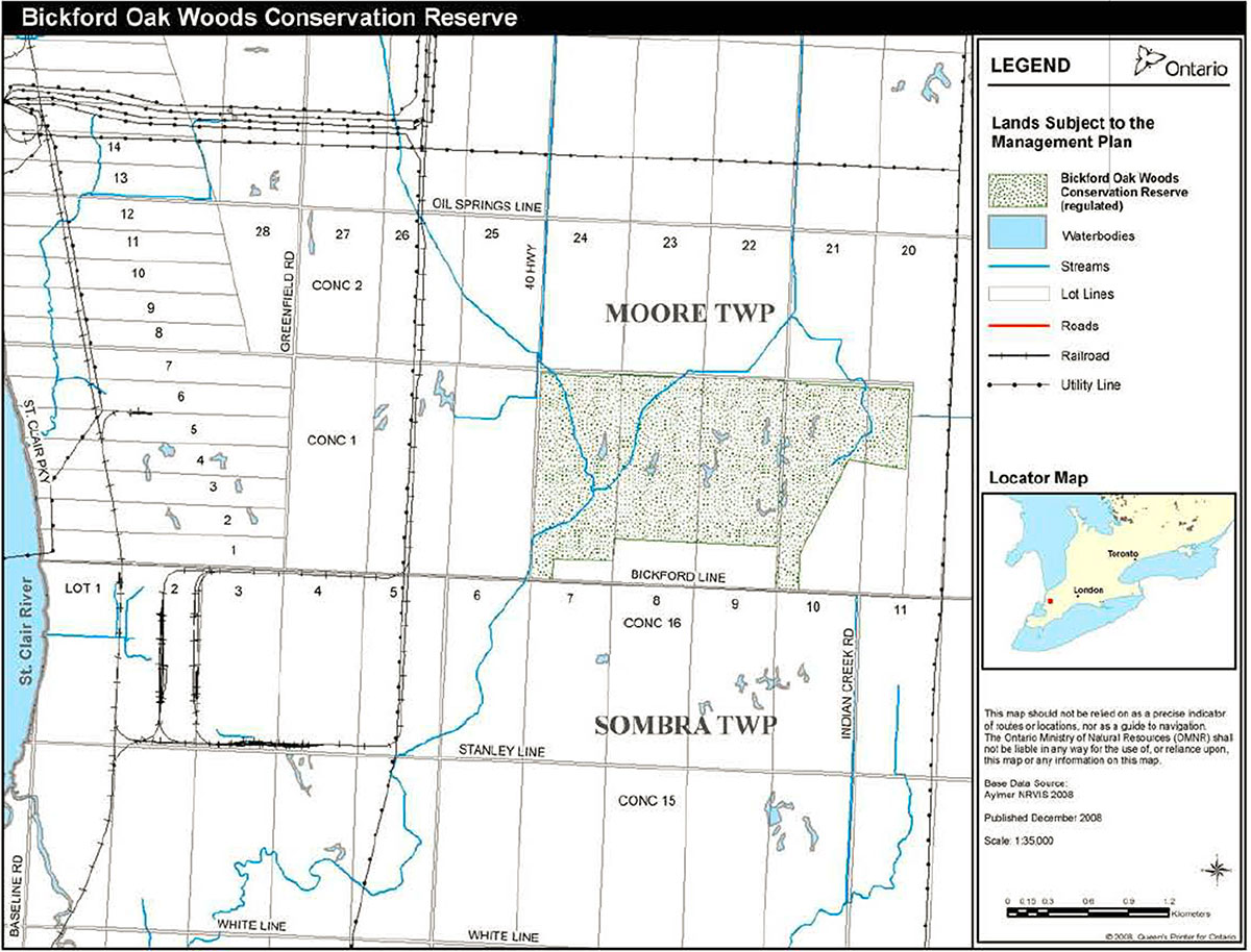
BOW CR is a 314 hectare property located in the Township of St. Clair, geographic township of Moore, in the County of Lambton (Figure 1). It is 25 kilometres south of Sarnia, just east of Highway 40 and north of Bickford Line. This site is the eastern limit of a six kilometre wooded corridor to the St. Clair River. This corridor is what remains of a larger forest complex locally known as the '1800 Block'.
1.2 Significance
BOW CR is the largest protected Carolinian clay plain forest in Canada. It is predominantly forested with scattered wetland pockets that provide habitat for a diversity of Carolinian species and communities including the provincially rare pin oak, Shumard oak, buttonbush thicket, cerulean warbler, tufted titmouse, and Carolina wren. In 2002, the first occurrence in Canada of swamp cottonwood was reported in BOW CR. Swamp cottonwood is a tree that is a candidate for endangered species status, both provincially and nationally.
This conservation reserve is located in Ecodistrict 7E2 and in the Carolinian Life Zone. This zone provides habitat for species more typically found south of the Canadian border. It represents the extreme southwest region of Ontario where the eastern deciduous forest of North America has its most northern limits. Approximately 215 hectares of the site is considered interior forest, which is defined as 100 metres or more from the forest edge. This type of habitat is not well represented in southern Ontario due to extensive forest loss and fragmentation. Protection of this interior Carolinian forest is highly important to the conservation of biological diversity and natural heritage in southern Ontario.
The '1800 Block' including BOW CR is a candidate for designation as a Life Science Area of Natural and Scientific Interest (ANSI). The conservation reserve will be managed in accordance with the ecological principles of Ontario’s Biodiversity Strategy.
1.3 Site History
BOW CR lies within the Lambton Clay Plain sub-region of the St. Clair Clay Plains physiographic region. The Lambton Clay Plain is a till plain overlain with a thin layer of clay deposited by a glacial lake.
Clearing, drainage and cultivation has altered BOW CR since the turn of the last century.
The site has been explored for petroleum potential. Seven petroleum wells have been drilled within the site; all wells are plugged or inactive. One natural gas pipeline crosses the southern portions of the site and a second abuts its northern and eastern limits.
Previous owners allowed cattle to pasture the site, which was a very common agricultural practice until about the 1970s when feedlot cattle operations replaced free range pasturing. This woodland has been logged until the 1980s. An apiary exists on the south west corner.
The natural hydrology of the site has been altered by artificial drainage. Agricultural drains cross the site with the western portion of the property being most heavily impacted. The presence of heavy clay soils and wetlands has probably contributed to the majority of BOW CR not being converted to cropland.
Hunting and trapping are known to have occurred within this site historically.
1.4 Planning Process
Bickford Oak Woods was designated as a conservation reserve, after public consultation, by amending the Chatham District Land Use Guidelines on March 31, 2004.
Bickford Oak Woods Life Science Inventory (Ambrose et al., 2005) provides additional information regarding the natural heritage found within BOW CR. Public and agency response to the Bickford Oak Woods Conservation Reserve: Issues and Options document and the Bickford Oak Woods Conservation Draft Management Plan were used to develop policies to conserve habitat, maintain natural heritage systems, and ensure permitted uses are compatible with the natural heritage values located within BOW CR. These sources of information assisted in the development of this management plan.
This management plan prescribes the policy direction for a 20-year period (2008 – 2028) that governs the use of the land that has been regulated as BOW CR.
This site has been regulated under the Provincial Parks and Conservation Reserves Act , by amending Ontario Regulation 199/08, to protect this important natural heritage and public recreation area.
Figure 1. Bickford Oak Woods Conservation Reserve
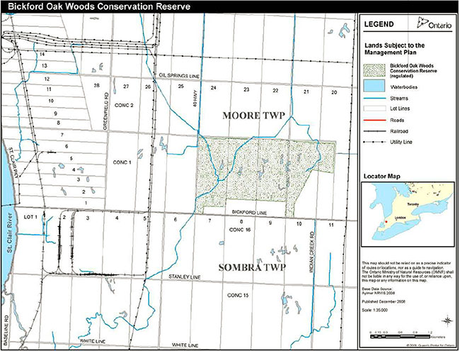
Enlarge Figure 1. Bickford Oak Woods Conservation Reserve
2. Goal
Ontario’s goal for Bickford Oak Woods Conservation Reserve is to:
Protect the significant natural heritage values of Bickford Oak Woods Conservation Reserve and maintain biodiversity while providing compatible recreational opportunities.
3. Objectives
MNR has established conservation reserves to offer protection for natural heritage in specific areas of public lands, while permitting recreational public land uses that are compatible with natural heritage protection. The maintenance of ecological integrity shall be considered in decision making.
The following three objectives will guide the management planning process:
Protection: Protect biodiversity and provincially significant elements of the natural landscape of Ontario and manage the area to ensure ecological integrity is maintained.
Recreation: Provide day use recreational opportunities and permit traditional public land uses which are compatible with natural heritage protection.
Research: Facilitate scientific research and provide points of reference to support monitoring of ecological change on the broader landscape.
4. Resource Stewardship Policies
Species at risk, vegetation, and wildlife resource stewardship policies may be further addressed in subsidiary management or implementation plans. Adaptive management principles, as defined in section 4.8 of this plan, will be used for the protection and restoration of the natural heritage values of BOW CR.
4.1 Species at Risk
Populations of species at risk (identified on the Species at Risk in Ontario list) and their habitats will be protected. Direction provided by species and ecosystem recovery strategies will be implemented where feasible.
4.2 Habitat Management
There are four main types of vegetation communities within the forested lands of this conservation reserve (as defined by the Ecological Land Classification for Southern Ontario): 1) swamp white oak mineral deciduous swamp, 2) green ash mineral deciduous swamp, 3) gray dogwood cultural thicket, and 4) a mosaic of swamp white oak mineral deciduous swamp and fresh-moist oak-sugar maple deciduous forest. The remainder of the site is composed of active agriculture fields (~8 ha).
The vegetation communities will be maintained, enhanced or restored as appropriate. Some of the communities will be managed by allowing natural ecosystems, processes and features to function normally. Where feasible and appropriate, more active management techniques will be used to meet other policies of this plan. Over time the existing agricultural fields will be converted to a more natural state that may include an appropriate complementary matrix of woodlands, wetlands and grasslands.
Restoration projects will use only locally occurring native species. Native species that were previously known to occur in the area may be re-introduced if appropriate.
BOW CR contains, and is surrounded by agricultural land and roads, which includes the presence of tile drains and agricultural drains. Activities and projects intended to restore natural drainage will be permitted where feasible. This may include the installation of appropriate water retention and control structures and the closing, rerouting or modification of existing drains. It could also include appropriate water retention works, including the creation of ponds on the existing agricultural fields. Any works that could impact agricultural drains would require municipal approval under the Drainage Act.
4.2.1 Fire Suppression and Prescribed Burning
Special management techniques may be required to maintain and restore vegetation communities of BOW CR. If ecologically appropriate, prescribed burns may be used in accordance with the Fire Management Policy for Provincial Parks and Conservation Reserves (PL 3.03.09) and the Class Environmental Assessment for Provincial Parks and Conservation Reserves to maintain and restore vegetation communities. For all other fires, the municipality provides fire response and suppression, as needed.
4.3 Wildlife and Fish
Wildlife and fish will continue to be managed in accordance with provincial and federal policies and regulations prevailing in the area. Recreational sport hunting will be permitted.
Activities and projects that protect and enhance wildlife and their habitat will be considered, such as the installation and maintenance of nest boxes. Native species that were previously known to occur in the area may be re-introduced, if appropriate.
Appropriate management techniques will be used to address threats to human health and safety presented by wildlife (e.g. rabies control). Management approaches for the control of fish and wildlife populations that threaten natural heritage values will be developed where feasible and appropriate. Access may be restricted to sensitive wildlife areas (e.g. heronry during breeding season).
BOW CR offers limited potential for fish habitat management; however future restoration projects that improve existing watercourses and water retention on the site may allow for the development of fish habitat and stocking of native fish species.
4.4 Insect Pests and Disease Suppression
Populations of native insects and diseases affecting vegetation or fish and wildlife within the conservation reserve will normally be allowed to develop undisturbed. Non-native insects and diseases may be controlled where feasible and necessary. Where control is undertaken, it will be directed as narrowly as possible to the specific insect or disease so as to have minimal effects on other components of the environment of the conservation reserve.
4.5 Non-native Species Introductions
Non-native species will not be deliberately introduced. Certain permitted uses within the conservation reserve disturb soil, thereby increasing the potential for invasive flora species to establish. Invasive non-native species may negatively impact native vegetation development. Management approaches for the eradication or control of non-native species that threaten natural heritage values will be developed.
4.6 Cultural Heritage
If archeological resources are discovered, appropriate steps will be taken in consultation with local First Nations and the Ministry of Culture to protect them. A Memorandum of Understanding with the Ministry of Culture requires that the cultural heritage resource screening process be implemented, should significant clearing of vegetation or soil disturbance or altering of land within this conservation reserve be considered.
Where a project involves ground disturbance in an area with archaeological potential, the project will be considered for impacts to archaeological resources. Where a project may impact on structures or cultural heritage landscapes, the project will be considered for potential effects to cultural heritage resources and appropriate mitigation measures will be considered. Staff will consult MNR's Technical Guideline for Cultural Heritage Resources.
4.7 Research and Education
Education and interpretation will be encouraged to provide a better understanding of the management and protection of the natural heritage values within BOW CR.
Scientific research by qualified individuals contributes to the knowledge of natural and cultural history and to environmental and recreational management. This type of research will be encouraged in BOW CR. All research programs will be reviewed on a case-by-case basis in the context of natural heritage protection. They will require the approval of MNR and will be subject to Ministry legislation and policy.
The local MNR office may approve the collection of specimens and/or parts of plants for an authorized research project. Specimens collected remain the property of MNR.
4.8 Inventory, Monitoring and Assessment
The Bickford Oak Woods Life Science Inventory provides the baseline inventory for the site. Additional inventories will be undertaken as necessary. For example, the site will be evaluated under the Ontario Wetland Evaluation System – Southern Manual to determine the significance of the wetlands. Inventory, monitoring and assessment will be used to determine the effectiveness of Resource Stewardship and Operational Policies. This may indicate a need to use adaptive management if expected results are not realized.
Adaptive management is a process for continually improving management policies and practices by learning from the outcomes of operational programs. Monitoring to assess whether management techniques are achieving the stated objectives is an essential component to adaptive management. All activities permitted, prohibited, or not yet identified to occur on the site will be monitored, as required, to ensure that natural heritage values and public safety are not compromised. Where monitoring indicates techniques are not effective, adjustments will be made to the operation and management of the site.
5. Operational Policies
5.1 Recreational Activities
Recreational activities and their impacts will be monitored. If a recreational activity is found to have an adverse effect on the natural heritage values of BOW CR, then the activity will be appropriately limited through an administrative amendment to this plan, as well as through the use of enforcement and mitigative measures. The property will be managed to meet the long-term goal of protecting the biodiversity and significant natural heritage values, while providing compatible recreational opportunities.
5.1.1 Permitted Activities
Horseback riding is permitted on MNR authorized trails designated for this use. Cross- country skiing is permitted on MNR authorized trails. Non-consumptive activities such as hiking, photography, wildlife viewing, and nature appreciation are permitted to occur.
Hunting and fishing are permitted according to provincial and federal legislation. Only temporary non-damaging tree stands are permitted.
5.1.2 Prohibited Activities
The following activities are prohibited within BOW CR:
- Overnight camping,
- Open fires,
- Private hunt camps,
- Mountain biking,
- Motorized vehicle use,
- Paint-ball activities,
- Put-and-take fish stocking, and
- Fuel wood collection.
There are no MNR authorized trails for the public to use motorized vehicles within BOW CR. Motorized recreational and utility vehicles are prohibited within BOW CR except within designated parking areas. MNR may authorize the use of motorized vehicles for enforcement, emergency, and management purposes.
5.2 Commercial Activities
5.2.1 Permitted Activities
Commercial fur harvesting is permitted according to provincial legislation.
Agricultural use on existing fields will be permitted until habitat restoration projects begin.
The existing beehives will be allowed to remain in designated areas. New beehive operations or expansions are prohibited. If land use conflicts arise, this use can be limited, moved or removed from BOW CR.
5.2.2. Prohibited Activities
Industrial activities within BOW CR are prohibited by legislation, including:
- Commercial timber harvest,
- Generation of electricity,
- Prospecting, staking mining claims, developing mineral interests or working mines,
- Extracting aggregate, topsoil or peat, and
- Other industrial uses.
New transmission lines, pipelines, and transportation corridors will be discouraged.
Commercial baitfish harvesting is prohibited.
New commercial activities, including tourism developments, are prohibited.
Pasturing of livestock is prohibited.
5.3 Infrastructure
There are two parking areas located on Bickford Line. To ensure public safety, direct access from Highway 40 is prohibited.
There are no authorized existing roads within BOW CR and private access roads are prohibited from being constructed.
Existing trails will be inventoried and rationalized to determine if they are sited and aligned in an environmentally sensitive manner. Trails may be opened, closed, abandoned, seasonally restricted, or moved in accordance with the provision of recreational opportunities that do not adversely affect the natural heritage values of the conservation reserve. Subsequently, an authorized trail network will be created and adequately marked. MNR may authorize individuals to clear obstructions from trails, and the deadfall must be left on site.
The signage at the conservation reserve will be improved to clearly communicate permitted and prohibited uses, authorized trails and boundaries.
A historical water well exists and will be decommissioned.
Major infrastructure will not be considered.
5.3.1 Pipeline Easements
One natural gas pipeline crosses the southern portions of the site and a second abuts its northern and eastern limits. The pipelines and their easements are considered to be an existing use of the site and will be permitted indefinitely. MNR management activities in the easement will conform to the terms and conditions of the existing agreement. The easements should be replanted with native forbs and grasses, to reduce opportunities for noxious weeds and exotic species invasions. MNR will work with the easement holder to ensure best management practices are followed to protect conservation reserve values when maintaining the pipeline easements.
Any trails, parking lots or fences over the pipeline or in the easement will require prior approval as per the National Energy Board guidelines.
5.3.2 Abandoned Petroleum Wells
Records indicate that seven petroleum wells have been drilled. All seven have been inspected by MNR's Petroleum Resources Section and are deemed to be safe.
5.4 Land Tenure and Adjacent Lands
Any unauthorized occupation of lands within the conservation reserve will be managed in accordance with MNR policies and relevant legislation and will be removed at the occupier’s expense. In addition, enforcement action may be taken.
Leasing or sale of parts or all of the conservation reserve is prohibited. Crown land dispositions (e.g. land use permit) in BOW CR will occur only in accordance with existing tenure documents, the landholding agreement with the Nature Conservancy of Canada and relevant policies and procedures. Existing land tenure may be transferred, renewed or amended as deemed appropriate.
Through municipal plan input and review, applications for large-scale development on private lands adjacent to the conservation reserve will be reviewed regarding impacts on the natural heritage values of BOW CR.
5.5 Enforcement
Enforcement will be carried out in accordance with MNR policies and relevant legislation to provide for the safety of visitors and the protection of resources.
5.6 Partnership Development
BOW CR became available to the public through partnerships. Future opportunities for partnerships and further cooperation will be encouraged in accordance with the policies of this plan. MNR may consider protecting, restoring or acquiring adjacent parcels of land.
6. Implementation
In the implementation of the approved management plan, MNR will pursue opportunities for partnerships with other agencies and groups. Undertaking resource stewardship projects and operations will be contingent upon approval and the availability of funding. Implementation of this management plan and operation of the conservation reserve will meet the requirements of the Environmental Assessment Act, Environmental Bill of Rights, Provincial Parks and Conservation Reserves Act, Fish and Wildlife Conservation Act, Endangered Species Act, and other pertinent legislation. All projects must be screened and completed in accordance with the Class Environmental Assessment for Provincial Parks and Conservation Reserves as well as ensure the maintenance of ecological integrity is addressed in accordance with the Provincial Parks and Conservation Reserves Act.
The following list of activities has been identified:
Stage 1
- Clean-up debris at petroleum well site
- Convert agricultural field to more suitable habitat including woodlands, wetlands and grasslands and consider viewing platform
- Restore natural hydrology where appropriate (e.g. remove tile drains)
- Control invasive and non-native species (e.g. control garlic mustard, Phragmites, Norway maple)
- Develop parking area(s) with associated trail access point(s)
- Inventory, assess and authorize trail network
- Install permitted/ prohibited use and boundary signage
- Pursue partnerships
Stage 2
- Complete application of Ontario Wetland Evaluation System to determine boundary and significance of wetlands
- Decommission water well
- Design and institute appropriate inventory and monitoring protocols
- Develop trails as appropriate
- Create educational signage and fact sheets
Ongoing
- Implement species at risk recovery strategies as appropriate
- Improve resource inventories and continue effectiveness monitoring
- Continue day-to-day maintenance (e.g. fences, signs, trails)
- Habitat management as required
7. Summary of Public Consultation
The Chatham District Land Use Guidelines (DLUG) was amended to designate Bickford Oak Woods as a conservation reserve on March 31, 2004 via Land Use Amendment (2003-09). Public consultation occurred between January 7, 2004 and February 6, 2004 regarding the designation of this site as a conservation reserve. The Environmental Bill of Rights (EBR) Environmental Registry Number was PB04E3010. Ninety-two responses were received and were considered in the development of this plan.
The management planning process has been posted on the EBR Environmental Registry as PB05E2809 (http://www.ebr.gov.on.ca/ERS-WEB-External/displaynoticecontent.do?noticeId=MjYxNTA=&statusId=MTUzMzc1&language=en). At each stage of the process, the Ministry has notified the public of the opportunity to review. This notice has been given through mailings to First Nations communities, resource users, local and provincial interest groups, government agencies, local landowners, general public and local politicians (municipal and provincial); as well as published in local and regional newspapers and posted on the EBR Environmental Registry.
Stage I: Invitation to Participate / Commencement of Planning included a 47-day comment period from August 22, 2005 to October 6, 2005. Ten comments were received during this consultation period. All comments were supportive to the management of BOW CR and related to permitted uses.
Stage II: Review of the Issues and Options included a 47-day comment period to review the Issues and Options document from October 26, 2005 to December 12, 2005. A public open house was held on November 16, 2005. A total of 110 comments were received during this consultation period; the vast majority of comments (80%) specifically supported hunting as a permitted use while 22 comments considered other issues and options.
Stage III: Public Review of the Draft Management Plan. This stage of the management planning process included a 45-day comment period to review the Draft Management Plan. Comments were accepted from February 3, 2006 to March 20, 2006. A public open house was held on February 15, 2006. A total of 35 comments were received. There were 29 comments in regard to permitted uses including: motorized access for the disabled, hunting, horseback riding, commercial baitfish harvesting, apiaries, fur harvesting, and ATV use.
Stage IV: Public Release of the Approved Management Plan.
Background information will be kept on file and made available as appropriate for public review at the MNR Chatham Area Office.
8. Reviews and Revisions
The Bickford Oak Woods Conservation Reserve Management Plan may be reviewed or amended to address changing issues or conditions. At ten year intervals this plan will be examined for the need for a review or amendment. A review may involve a reassessment of all or part of the plan. An amendment can be considered to address specific issues or needs.
9. Bibliography
Ambrose, J. D., G. Waldron, D. Martin, L. J. Rodger and P. A. Woodliffe. 2005. A Life Science Inventory of Bickford Oak Woods, Lambton County, Ontario. Ontario Ministry of Natural Resources. 67 p.
Chapman, L.J., and D.F. Putnam. 1984. The Physiography of Southern Ontario. Third Edition. Ontario Geological Survey, Special Volume 2. Ontario Ministry of Natural Resources. Government of Ontario. 270 p.
Jalava, J.V., P.J. Sorrill, J. Henson and K. Brodribb. 2000. The Big Picture Project: Developing A Natural Heritage Vision for Canada’s Southernmost Ecological Region. Science and Management of Protected Areas Association (SAMPA IV) Conference Proceedings. Manuscript submitted.
Lee, H., W.Bakowsky, J.Riley, J.Bowles, M.Puddister, P.Uhlig and S. McMurray. 1998. Ecological Land Classification for Southern Ontario, First Approximation and Its Application. SCSS Field Guide FG-02 September 1998. Ontario Ministry of Natural Resources, Southcentral Science Section, Science Development and Transfer Branch, North Bay, ON. 225 p.
Natural Heritage Information Centre, http://nhic.mnr.gov.on.ca/nhic_.cfm
Ontario Ministry of Natural Resources. 2006. Technical Guideline for Cultural Heritage Resources. 145 p.
Ontario Ministry of Natural Resources. 2005. Bickford Oak Woods Conservation Reserve: Issues and Options. 18 p.
Ontario Ministry of Natural Resources. 2005. Ontario’s Biodiversity Strategy: Protecting what sustains us. 44 p.
Ontario Ministry of Natural Resources. 2005. A Class Environmental Assessment for Provincial Parks and Conservation Reserves. 134 p.
Ontario Ministry of Natural Resources. 2004. Fire Management Policy for Provincial Parks and Conservation Reserves. Ontario Parks/Aviation and Forest Fire Management/Lands and Waters Branches. Directive No. FM 2:12; PM 11.03.03; PL 3.03.09. 5 p.
Ontario Ministry of Natural Resources. 2003. A Class Environmental Assessment for MNR Resource Stewardship and Facility Development Projects. 80 p.
Ontario Ministry of Natural Resources. 1991. Prescribed Burning. Policy No. FM 2:10. Aviation and Forest Fire Management Branch. Amended 1995. 2 p.
Rodger, L. 1998. Tallgrass Communities of Southern Ontario, A Recovery Plan. Prepared by Lindsay Rodger for World Wildlife Fund Canada and the Ontario Ministry of Natural Resources. World Wildlife Fund, Toronto.
Rowe, J.S. 1972. Forest Regions of Canada. Canadian Forestry Service Publication No. 1300. Department of Fisheries and the Environment. Ministry of Supply and Services Canada, Ottawa, Ontario.
Sit, V. and B. Taylor (editors). 1998. Statistical Methods for Adaptive Management Studies. Res. Br., British Columbia Ministry of Forests, Research Branch, Victoria, BC, Land Management Handbook. No. 42.