Campus Lake Conservation Reserve Management Statement
This document provides policy direction for the protection, development and management of the Campus Lake Conservation Reserve and its resources.
Campus Lake Conservation Reserve (C2299) Resource Management Plan
Ministry of Natural Resources
Atikokan Area
Fort Frances District
April 2005
John Munroe
District Planner
Approval Statement
I am pleased to approve the Campus Lake Conservation Reserve Resource Management Plan.
This resource management plan will provide guidance for the management of the conservation reserve and the basis for the ongoing monitoring of activities.
The public was widely consulted during the regulation process for this site. The Campus Lake Conservation Reserve will be managed by Fort Frances District and Dryden District of the Ministry of Natural Resources.
Signed by:
Wm. Darby
District Manager
Fort Frances District
Date: November 10, 2005
Signed by:
Mark Sobchuk
Acting District Manager
Dryden District
Date: February 16, 2006
Signed by:
Charles Lauer
Regional Director
Northwest Region
Date: April 18, 2006
1.0 Introduction
On July 16, 1999, the Ontario Government released the Ontario’s Living Legacy Land Use Strategy to guide the planning and management of Crown lands in central and parts of northern Ontario. A major part of the Ontario’s Living Legacy Land Use Strategy (OMNR, 1999a) was a government intent to establish 378 new protected areas. The Campus Lake Conservation Reserve is part of this expansion of Ontario’s protected areas system. In May, 2003 the site was regulated as a conservation reserve under the Public Lands Act.
Conservation reserves are areas of Crown land set aside by regulation under the Public Lands Act, complementing provincial parks in protecting representative natural areas and special landscapes. Most recreational (e.g. hiking, skiing, tourism related uses, nature appreciation) and non-industrial (e.g. fur harvesting, commercial fishing and bait harvesting) activities that have traditionally been enjoyed in the area will continue, provided that these uses do not impact on the natural features needing protection. Hunting and fishing is permitted within all new conservation reserves proposed through Ontario’s Living Legacy.
Commercial timber harvesting, mining, aggregate extraction and commercial hydroelectric development are prohibited in conservation reserves.
The Campus Lake Conservation Reserve was designated to conserve representative landform and vegetation types, including wetland communities and mixed conifer and deciduous forest types on weakly broken beach and aeolian deposits and weakly broken ground moraine. It also encompasses some spectacular scenic and recreational areas adjacent to Turtle River - White Otter Lake Provincial Park (OMNR, 1999a). This Resource Management Plan for the Campus Lake Conservation Reserve describes the features, values and uses within the area, outlines the policies that apply, and states the management direction to be taken in terms of objectives and implementation strategies. Planning, management and the uses permitted within this conservation reserve are consistent with the commitments of the Ontario’s Living Legacy Land Use Strategy and Conservation Reserves Policy and Procedure (OMNR, 1997a).
Public consultation was carried out in the preparation of this plan in conjunction with the preparation of a Management Guideline for the adjacent White Otter Enhanced Management Area. Notices of opportunities to participate in the planning exercise were mailed to potentially interested persons, including nearby landowners, resource users and other stakeholders, municipalities and others who may have an interest in the areas. First Nation organizations with a potential interest in the area were also notified. Advertisements inviting public participation were placed in local newspapers, and notices were posted on the Environmental Bill of Rights Environmental Registry website. Information sessions were held in the communities of Ignace and Atikokan at various times throughout the process. The input received during consultation was taken into consideration in the decision-making process in preparing the resource management plan. Consultation is further discussed under section 6.0 of this plan and a summary of the public consultation carried out and input received is contained within Appendix F.
2.0 Location, Area and Status
Campus Lake Conservation Reserve is located in northwestern Ontario in the Fort Frances and Dryden Administrative Districts of the Ontario Ministry of Natural Resources, approximately 12 kilometres south of the community of Ignace and 33 kilometres north of the town of Atikokan. The site is approximately 19,452 hectares in size. Highway 17 lies to the north, Highway 11 to the south and Highway 622 to the west, although the conservation reserve itself is not directly accessible by road. The area encompasses Campus, Elsie, Mable and Sandford Lakes, portions of the Turtle River and associated waters. The boundary of the Campus Lake site adjoins Turtle River-White Otter Lake Provincial Park to the west, and the White Otter Enhanced Management Area to the southwest. The remainder of the area surrounding the conservation reserve consists of largely undeveloped Crown land in which the dominant land uses are recreation and forestry. A power transmission corridor bisects the conservation reserve, running north and south to the west of Sandford, Mable and Campus Lakes. Figure 1 displays the location of the conservation reserve in a regional context.
The area lies entirely within the Northwest Region of the Ontario Ministry of Natural Resources, and management of the area overall will be a co-operative effort between Dryden and Fort Frances Districts, with the Fort Frances District taking the lead role in planning matters. Planning for the area will also be conducted in consultation with Ontario Parks, who have responsibility for planning and management of the adjacent Turtle River - White Otter Lake Provincial Park.
The area occupied by the Campus Lake Conservation Reserve was originally a part of the Greytrout land use area designated under the Atikokan District Land Use Guidelines (OMNR, 1983a), and the Kathleen/Phyllis Lakes and Megikons/Crystal River land use areas designated under the Ignace District Land Use Guidelines (OMNR, 1983b). A project was initiated by MNR in 2000 to consolidate the land use policy direction contained within the District Land Use Guidelines and the Ontario’s Living Legacy Land Use Strategy. The result was the web-based Crown Land Use Policy Atlas (OMNR, 2003a). The area of the conservation reserve is identified as a unique land use area within the Atlas with its own policies drawn from the Land Use Strategy and the Conservation Reserves Policy and Procedure (OMNR, 1997a).
In addition to the extensive consultation that was carried out during the Ontario’s Living Legacy planning exercise, public consultation on the boundaries of the site was carried out in 2000 to assist in the preparation of the regulation plan. In May 2003, the site was formally regulated as a conservation reserve under the Public Lands Act.
Reconnaissance earth science, life science and recreational inventory surveys were carried out for the site between 2000 and 2003 to provide basic resource management information to supplement the pre-existing knowledge and sources of information relating to the conservation reserve.
This relatively large conservation reserve straddles two eco-districts and contains portions of eco-regions.
The policies, guidelines and other provisions outlined in this document do not supersede any Aboriginal or Treaty rights that may exist, or other legal obligations. The area lies entirely within the Treaty Three area.
Figure 1. Location of Campus Lake Conservation Reserve
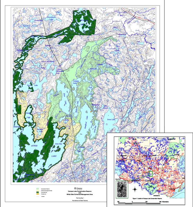
Enlarge Figure 1. Location of Campus Lake Conservation Reserve
3.0 Values, Features and Uses
3.1 Values and Features
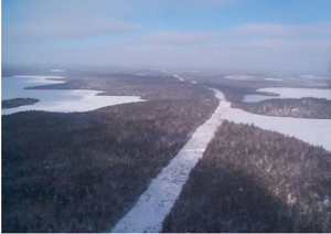
3.1.1 Infrastructure
Little development has occurred within the area of the Campus Lake Conservation Reserve. Apart from those few privately owned parcels in the area, infrastructure is essentially limited to the hydro transmission corridor that runs through the site between Elsie Lake and Campus and Mable Lakes. A rudimentary access trail follows this corridor.
Figure 2: Hydro transmission corridor through the conservation reserve (Elsie Lake on the left, Campus Lake on the right).
There are six small, patented (private) properties on lakes within the reserve: three on Sandford Lake, one on Mable Lake and two on Elsie Lake. Although surrounded by conservation reserve lands, these properties are not part of the conservation reserve. All the properties contain buildings and associated structures and all but one are summer homes or camps. One property on the north end of Sandford Lake supports a main base tourist lodge and guest cabins.
Three trapper’s cabins are located within the conservation reserve: one on Fish Lake, one on Sandford Lake and one on lower half of Halfmoon Lake. One commercial tourist outpost cabin exists within the boundaries of the conservation reserve, on Halfmoon Lake.
3.1.2 Access Points and Facilities
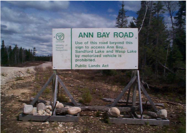
No direct road access exists to the conservation reserve, although forest access roads do approach from both the north and south. In the south, where an extension to the Ann Bay road crosses the Ann Bay portage, access restrictions are in place that expressly prohibits vehicles from using the Ann Bay Road to access either Sandford Lake or White Otter Lake. This area and areas to the north and west of the conservation reserve comprise the White Otter Enhanced Management Area (EMA) that was designated under Ontario’s Living Legacy Land Use Strategy for the purpose of carrying out forest management activities in a manner that will facilitate future eco-tourism activities and backcountry recreation. Controlled access is a fundamental principle in the management of the area. The forest management plans for the area must contain road use strategies for any roads constructed within the EMA with the guiding principles being that forest access roads will be kept to a minimum, planned to the lowest class possible, closed to public travel and physically abandoned when no longer required for forestry purposes.
Figure 3: Access restrictions on the Ann Bay Road.

Enlarge Figure 3: Access restrictions on the Ann Bay Road
Tertiary forest access roads associated with forestry operations predating the Land Use Strategy enter the reserve to the south of Bentarm Lake and to the northeast of Campus Lake and Campus Creek, but these have not been maintained and the limited access that this represents is deteriorating over time.
Traditionally the area has been accessed by water and portage through Turtle River- White Otter Lake Provincial Park, or by floatplane. Access to the park may be gained from the south via the Ann Bay Road off Highway 622 and a landing on White Otter Lake; from the northwest from an access point on Highway 622 where it crosses the Turtle River; and from Ignace via Agimak Lake, McNamara Lake and the Balmoral River. From White Otter Lake, the conservation reserve may be accessed by portage across the Ann Bay Portage between White Otter and Sandford Lakes, or by traveling upstream on the Turtle River. Portages also exist connecting Sandford Lake to the Gamble River and Wasp Lake to the south and to Irene Lake to the east. Campus Creek to the northeast is not considered navigable.
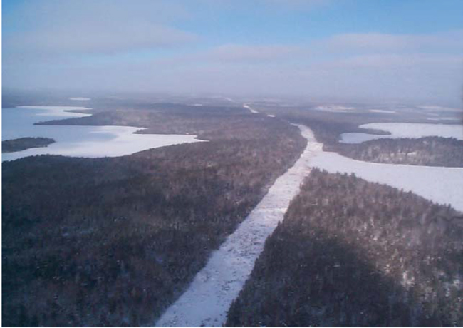
A portion of the Ontario Federation of Snowmobile Clubs provincial trail network runs north south through the conservation reserve, connecting the communities of Ignace and Atikokan. Trail permits are required to use sanctioned trails groomed and maintained by the snow machine clubs.
A trail for service purposes follows the hydro corridor running between Elsie Lake and Mable and Campus Lakes. The snow machine clubs in Atikokan and Ignace requested authorization to use this trail as an alternative to the previous route that ran over the ice of Sandford, Mable and Campus Lakes in the winter, as a safer and more reliable alternative. This option was included in consultation materials made available to the public in the preparation of this plan. A decision to permit this use was made based upon recognition of the safety concerns identified, the fact that the area was already accessible by snow machine and that the proposal would be largely confined to an existing trail see (Section 4.5.13).
Portages and trails within the conservation reserve are not regularly maintained, nor are other facilities provided.
3.1.3 Cultural Heritage and Historical Development
Little historical documentation exists specific to the area of the Campus Lake Conservation Reserve. Much of the history of the area must therefore be inferred from sources that describe the history of surrounding areas or the region in which it lies as a whole. Some of this can be substantiated in part by physical evidence that remains of past human activities. The locations of some cultural heritage sites that have been identified within the conservation reserve are kept confidential owing to the sensitivity of such sites to disturbance.
It is known that the earliest inhabitants of the region following the last ice age approximately 9000 years ago were the Palaeo-Indian people of the Plano culture. Although little is known about these people, it is believed, based upon artifacts that have been discovered, that they were hunters of large game, presumably caribou that ranged across the open park land and tundra along the ice margins. Their campsites were located along the old shorelines of Glacial Lake Agassiz (Ross, 1979; Wright, 1972). At the time of the lake’s greatest extent, it is believed that the upland area occupied by the conservation reserve stood as part of a large peninsula (Prest, 1976; Teller et al, 1983). It is therefore unlikely that more permanent campsites exist within the site itself, although the early hunters may have ranged across the area in search of game.
With the changes in climate that followed the recession of the glaciers, the plant and animal communities of the area changed as well, to those favouring the warmer, drier conditions. The advance of prairie grasslands into the area from the south and west appears to have drawn a new group not related to the Plano people, known as Plains Archaic peoples (Ross, 1979). Artifacts left by the people of the Archaic period, that began about 7000 years ago, included fishing implements as well as hunting points. The points tended to be smaller than those of earlier peoples, perhaps reflecting smaller or more diverse game.
Following the Archaic cultures were three periods known as the Initial, Middle and Terminal Woodland periods, beginning approximately 2500 years ago (OAS, 2003). The major discriminating factor differentiating these later cultures, known as the Laurel culture, from earlier peoples was the appearance of ceramic pottery. It is unknown whether these people were descended from the Archaic peoples or whether they entered the area later. Evidence supports the theory that elaborate trade routes existed between the groups across North America at the time, with artifacts indicating the exchange of goods from as far away as the Atlantic (Wright, 1972). These trade routes followed the major waterways, and so it is probable that the area of the conservation reserve, being outside of such areas, was sparsely populated then, as it is today. It is likely that the area enjoyed some use by itinerant hunter-gatherer parties. Certainly, the Turtle River would have provided an access route to and from the interior, and there has been evidence discovered of such use.
The Terminal Woodland period gave rise to what is known as the Blackduck culture, known by its distinctive style of pottery. These people may have been the ancestors of the present-day Ojibway peoples, although this is not known for certain. This period is also noted for the practice of rock painting or producing pictographs, representations of animals and spirits in mixtures of red ochre placed upon exposed rock faces. Examples of such pictographs have been found within the conservation reserve, as well as the adjacent Turtle River-White Otter Lake Provincial Park. The latter part of the Woodland period coincides with the arrival of Europeans in North America in the late 1600's.
Early European explorers first arrived in the area west of Lake Superior in 1688, and this heralded the beginning of the fur trade in the area, with the establishment of forts and posts along the trade routes. The main routes were located to the south of the conservation reserve along the boundary waters and the larger rivers and lakes. Again, it is likely that native people throughout this period used the area of the site for trapping, but it did not see the development that occurred elsewhere. The fur trade continued up until the advent of the railways, beginning with construction of the Canadian Pacific line in 1882 followed by the Canadian Northern Railway (later the Canadian National Railway) in 1899. The routes followed by these rail lines passed to the north and south of the area in which the conservation reserve is located and once again, development tended to occur along the transportation corridors, with the Campus Lake area remaining undeveloped. Mineral exploration and development during this time was also taking place, but focused on greenstone belts outside of the area of the conservation reserve.
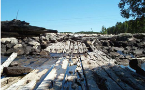
During the construction of the railways and subsequent mining operations, there was a great demand for timber for both ties and mine timbers. This demand resulted in the rapid development of a sawmilling industry in the region. Of particular interest to logging companies in the early part of the 20th century were the stands of red and white pine that were common throughout the district. The principal company harvesting timber in the area was the Shevlin-Clarke company, to feed its sawmill in Fort Frances. This company conducted operations throughout the district, including operations in the White Otter Lake area adjacent to the conservation reserve, up until 1946 (OMNR, 1981; OMNR, 2000b). Beginning in the 1930, the J.A. Mathieu Company also harvested timber in the White Otter Lake country, to feed mills first in Fort Frances, and later in Sapawe, located to the east of Atikokan. The wood from these operations was floated down the rivers in the area to the mills, beginning with the Turtle River, and later the Little Turtle River. Various structures were constructed along these log drive routes to facilitate the movement of the timber, including dams, weirs and sluiceways, and channels were often modified to allow unobstructed passage or to direct the logs. Remnants of many of these works remain today along the Turtle River within the conservation reserve. It is unknown how extensive the logging within the conservation reserve itself was, with operations centered to the west around White Otter Lake. Certainly, the log drive structures within the area suggested that harvesting did take place, although other overt signs of this are not evident today. By the early 1950, the emphasis had shifted to dimension lumber using jack pine and spruce, and pulpwood, and the log drive ended with the development of the road haul using trucks. Operations then shifted to more accessible areas to the south and north, off highways 11 and 17.
Figure 4: Abandoned log sluice below weir at the outlet of Mable Lake.
Enlarge Figure 4: Abandoned log sluice below weir at the outlet of Mable Lake
3.1.4 Natural Values and Features
3.1.4.1 Earth Science
3.1.4.1.1 Bedrock Geology
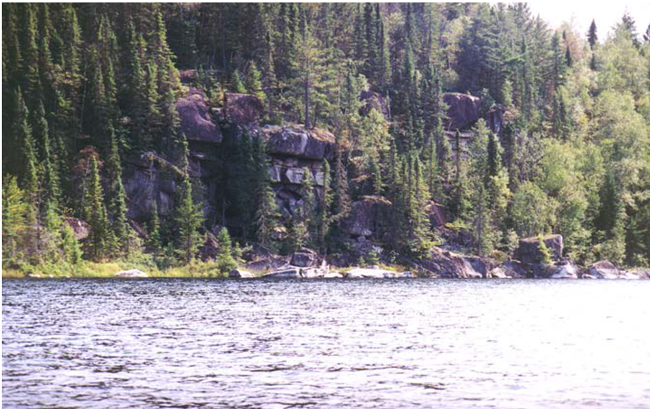
The Campus Lake Conservation Reserve lies within the central Wabigoon Sub-province plutonic belt with rock types dominated by massive granites and granodiorites ranging from 2.5 to 3.4 billion years of age (Cowell, 2000). The reserve sits entirely atop the White Otter Lake Pluton. Bedrock scarps and cliffs occur periodically throughout the southern portions of the area, most dramatically along the shorelines of the larger lakes. The area is classified as having low (least) mineral potential (Springer, 1978).
Figure 5: Bedrock cliff on Halfmoon Lake.

Enlarge Figure 5: Bedrock cliff on Halfmoon Lake
3.1.4.1.2 Surficial Geology and Landforms
The northern portions of the conservation reserve differ significantly from the southern portions in terms of landform. The northern portion lying north of Campus Lake is generally of low topographic relief, has only a few, small lakes and is dominated by poorly drained peatlands. The southern parts of the conservation reserve, by contrast, are dominated by large lakes, are moderately to steeply rolling and are mostly uplands. Elevations across the site range from 420 to 520 metres. The site is located approximately midway between the Eagle-Finlayson terminal moraine, which lies to the southwest, and the Hartmann terminal moraine located to the north at Ignace.
Surficial deposits within the conservation reserve include silty sand till (ground moraine), glaciofluvial outwash, and glaciolacustrine sands and silts resulting from reworking of the till and glaciofluvial deposits by shallow glacial waters (Cowell, 2000). A discontinuous mantle of sandy till overlying bedrock covers much of the area of the site. Of particular note is the occurrence of a layer of glacial wind blown materials (loess) up to 45 cm thick overlying ground moraine. These deposits have been noted elsewhere in this part of the District (Zoltai, 1961) and are considered regionally significant. The organic terrain along Campus Creek is underlain by an extensive sandy outwash plain.
Figure 6: Glacial melt water channel along the course of the present-day Turtle River, between Elsie and Mable Lakes.
Recent (post-glacial) deposits within the conservation reserve are represented by the extensive peat deposits along Campus Creek at the north end of the reserve, sand beaches, which are common along the lakeshores and sand bars and spits along the Turtle River, especially on the western side of the site. Organic deposits of recent origin also occupy the small depressions between the bedrock-dominated uplands.
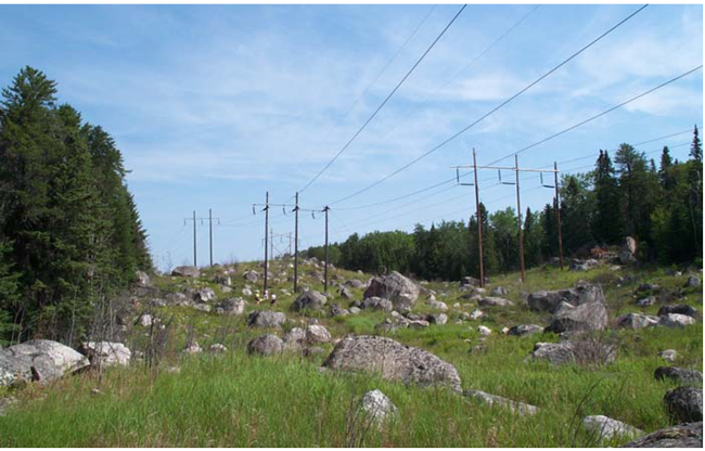
Figure 7: Glacial erratics along power line between Elsie and Mable Lakes.

Enlarge Figure 7: Glacial erratics along power line between Elsie and Mable Lakes
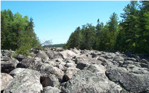
Other surficial features that are noteworthy within the conservation reserve are boulder-strewn melt water channels that occur distinctively throughout, and the localized profusion of very large glacial erratics in the southern portions of the area.
3.1.4.2 Life Science
The Campus Lake Conservation Reserve straddles the boundaries between revised eco-regions 4W and 4S, in eco-districts 4W-1 and 4S-5 (refer to Figure 8). The eco-regions of Ontario are geographic designations or subdivisions of the land base within which specific plant communities occur upon specific landform positions (Burger, 1993; Hills, 1961). Such regions are defined based upon a combination of climatic factors, physiography and vegetation.
Figure 8: Location of the conservation reserve on the boundary of Eco-regions 4S and 4W.
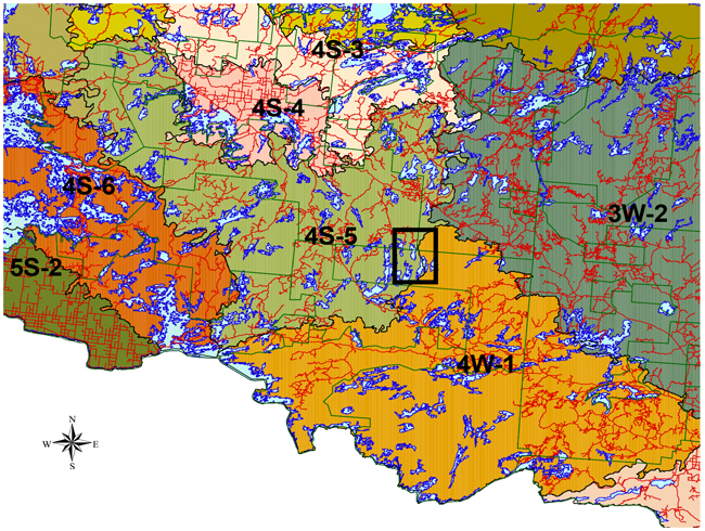
Enlarge Figure 8: Location of the conservation reserve on the boundary of Eco-regions 4S and 4W
3.1.4.2.1 Forest Cover and Ecosite Types
The Campus Lake Conservation Reserve lies within an area of northwestern Ontario that is transitional between the Great Lakes-St. Lawrence Forest Region and the Boreal Forest Region. It is recognized as part of a separate section that is influenced by the northward movement of the southern forest, the prairie to the west and the northern forest (Rowe, 1972). The most overt manifestation of this transition is the presence of abundant red and white pine in the area.
As noted earlier under Section 3.1.4.1.2, the northern portions of the conservation reserve differ significantly from the southern portions. The north is dominated by peat lands with low topographic relief and forest cover tends to be dominated by black spruce and tamarack (larch). By contrast, the southern portions of the conservation reserve, surrounding and between the larger lakes, tend to be upland with mineral soils and moderately to steeply rolling terrain. This southern portion tends to be dominated by conifer and hardwood mixed woods. Overall, not including water, 17% of the area of the conservation reserve is classified as wetlands. Of this wetland area, 33% is open wetland while the balance is treed or forested wetland types.
Jack pine, black spruce, white birch and aspen in that order dominate the most abundant forest stand types, with jack pine dominating 35% of the forested area. Most of the forest within the conservation reserve arose from fires that burned through the area in the 1920's and 1930's. The origins of some stands predate this period, with the oldest stands in the conservation reserve being over 200 years old, represented by white pine. Some lowland black spruce stands on the area are up to 150 years of age. Overall, approximately 3% of the forest within the site is greater than 120 years of age and approximately 5% is greater than 100 years of age. Younger forest is also represented, largely as a consequence of more recent logging on the margins of the northern portions of the area. Approximately 3% of the total forested area is currently less than 20 years of age. Maps 4 and 5 in Appendix C display forest cover types and ecosites, respectively, within the conservation reserve, and Appendix D contains detailed forest stand information.
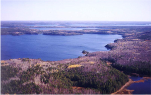
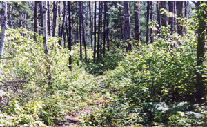
Figure 9: Mixed wood forest of the conservation reserve, looking southeast across Elsie Lake towards Mable and Sandford Lakes.
A total of 36 ecosite types have been identified within the area, based upon the Northwestern Ontario Forest Ecosystem Classification (Sims et al, 1989), (Racey et al, 1996), including 23 upland types as well as 13 wetland types. Mapped ecosites include:
- ES1 Beach / Bar
- ES7 Rock Barren
- ES11 Red Pine - White Pine - Jack Pine: Very Shallow Soil
- ES12 Black Spruce - Jack Pine: Very Shallow Soil
- ES13 Jack Pine - Conifer: Dry - Moderately Fresh, Sandy Soil
- ES14 Pine - Spruce Mixed wood: Sandy Soil
- ES15 Red Pine - White Pine: Sandy Soil
- ES16 Hardwood-Fir-Spruce Mixed wood: Sandy Soil
- ES18 Red Pine - White Pine: Fresh, Coarse Loamy Soil
- ES19 Hardwood-Fir-Spruce Mixed wood: Fresh, Sandy - Coarse Loamy Soil
- ES20 Spruce-Pine / Feathermoss: Fresh, Sandy- Coarse Loamy Soil
- ES21 Fir - Spruce Mixed wood: Fresh, Coarse Loamy Soil
- ES22 Spruce-Pine / Ledum / Feathermoss: Moist, Sandy - Coarse Loamy Soil
- ES23 Hardwood-Fir-Spruce Mixed wood: Moist, Sandy - Coarse Loamy Soil
- ES24 Red Pine - White Pine: Fresh, Fine Loamy Soil
- ES26 Spruce-Pine / Feathermoss: Fresh, Fine Loamy - Clayey Soil
- ES27 Fir - Spruce Mixed wood: Fresh, Silty - Fine Loamy Soil
- ES29 Hardwood-Fir-Spruce Mixed wood: Fresh, Fine Loamy - Clayey Soil
- ES30 Black Ash Hardwood: Fresh, Silty - Clayey Soil
- ES31 Spruce-Pine / Feathermoss: Moist, Silty - Clayey Soil
- ES32 Fir - Spruce Mixed wood: Moist, Silty - Clayey Soil
- ES34 Treed Bog: Black Spruce / Sphagnum: Organic Soil
- ES35 Poor Swamp: Black Spruce: Organic Soil
- ES36 Intermediate Swamp: Black Spruce (Tamarack): Organic Soil
- ES39 Open Bog: Ericaceous Shrub / Sedge / Sphagnum: Organic Soil
- ES40 Treed Fen: Tamarack - Black Spruce / Sphagnum: Organic Soil
- ES41 Open Poor Fen: Ericaceous Shrub - Sedge / Sphagnum: Organic Soil
- ES42 Open Moderately Rich Fen: Ericaceous Shrub / Sedge: Organic Soil
- ES44 Thicket Swamp: Organic-Mineral Soil
- ES45 Shore Fen: Organic Soil
- ES46 Meadow Marsh: Organic - Mineral Soil
- ES47 Sheltered Marsh: Emergent: Sedimentary Peat Substrate
- ES48 Exposed Marsh: Emergent: Mineral Substrate
- ES49 Open Water Marsh: Submergent / Floating-leaved: Sedimentary Peat Substrate
- ES55 Shallow Water: Sparsely Vegetated: Cobble
- ES56 Shallow Water: Sparsely Vegetated: Stone
The dominant ecosite types within the reserve are ES19 and ES20, Hardwood-Fir- Spruce mixed wood and Spruce-Pine / Feathermoss on fresh, sandy to coarse loamy soils. Together, these two ecosites represent approximately 44% of the area of the conservation reserve exclusive of water. The least abundant ecosite types represented are ES48 Exposed Marsh, ES1 Beach / Bar and ES47 Sheltered Marsh. Although these species are visually dominant within the conservation reserve, it is worthy of note that the white and red pine ecosites (ES11, ES15, ES18 and ES24) represent only 5% of the non-water area of the site.
It should be noted that the classification represents a generalization of the ecosites occurring on the area, and that considerable variation within a designated ecosite may be found as one-type grades into another. Smaller areas of other ecosites may also occur within the area. Map 5 in the appendices displays the distribution of the ecosites represented within the conservation reserve.
3.1.4.2.2 Species and Diversity
No detailed survey of the life science features of the conservation reserve has been completed at this time. Reconnaissance surveys completed on the area have, nevertheless, identified some of the primary features and species found within the site.
The landscape diversity represented within the site, with fully 36 of 56 ecosite types and 32 of the 40 forested and wetland ecosite types in the classification system represented, is significant. Also at a landscape level, the site has representation for conifer, conifer mixed woods, hardwood, and hardwood mixed woods and sparse forest, on moderate to steeply broken ground moraine, weakly to moderately broken outwash plain and weakly to steeply broken bedrock knob terrain.
Tree species known to occur within the conservation reserve include white pine, red pine, jack pine, black spruce, white spruce, tamarack, balsam fir, eastern white cedar, trembling aspen, white birch and black ash. The presence of white cedar on the site is significant. Although not abundant, this species is normally associated with carbonatized rocks of the greenstone belts, not the acidic igneous rocks that dominate the conservation reserve. Its presence here might indicate carbonate content in the glacial drift derived from rocks elsewhere. The vegetation of the conservation reserve is typical of the ecosites represented, with no rare plants listed in the Natural Heritage Information Centre database having been documented for this site.
There are five identified bald eagle nesting sites and one identified osprey-nesting site within the conservation reserve. Eagles are quite common in this area despite the fact that they are listed as an endangered species in the province as a whole. One Great Blue Heron colony has also been documented on the border of the reserve. Other avian species commonly found within the site include Common Raven, Pileated Woodpecker, Belted Kingfisher, Herring Gull, Ruffed Grouse, Spruce Grouse, Common Loon, Turkey Vulture and Canada Jay.
There are 12 moose aquatic feeding areas that have been identified within the conservation reserve, all in the northern portions of the site surrounding the wetlands, which dominate this location. Other animals noted within the site include black bear, white-tailed deer, snowshoe hare, beaver, river otter, red squirrel, Eastern garter snake and snapping turtle.
Fish species found within the waters of the conservation reserve include lake trout, whitefish, walleye, yellow perch, white sucker, northern pike, and smallmouth bass. The lake trout in Sandford Lake are known to grow to quite a large size, and the largest on record in Ontario for inland waters came from this lake.
3.1.4.3 Water Resources
The waters of Campus Lake Conservation Reserve lie within the Arctic watershed and drain to the west through the Turtle River, representing a headwater area for Rainy Lake, which lies approximately 80 kilometres to the southwest.
The conservation reserve contains 46 lakes, in whole or in part, ranging in size from less than a hectare to almost 3000 hectares in the case of the largest lake in the reserve, Sandford Lake. The total water area within the conservation reserve, including lakes, rivers, streams and ponds, is approximately 7000 hectares or 35% of the total area of the site. The reserve also contains approximately 80 kilometres of river and stream. The larger lakes within the site tend to be deep, clear, coldwater lakes, often with a distinctive blue-green tint to the waters when seen from a distance. Some of the smaller lakes, particularly those associated with the peatlands to the north, are the more typical tannin-stained warm water lakes so commonly found in the boreal forest.
Only the larger lakes within the conservation reserve have been surveyed, and include Sandford, Elsie, Mable, Campus and Fish Lakes. Sandford is the deepest lake in the conservation reserve, with a maximum-recorded depth of 115 metres (377 feet), and a mean depth of 37 metres (121 feet). Although the larger lakes tend to be deep, coldwater lakes, considerable variation does exist, both within the basins occupied by individual lakes and between lakes. Campus is the shallowest of the larger lakes, with a mean depth of 8 metres (26 feet) and a maximum-recorded depth of 22 metres (72 feet). It also has the greatest area of littoral zone (shallow water) at 47%. The other surveyed lakes have littoral zones ranging from 14% (Sandford Lake) to 30% (Fish Lake).
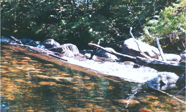
The conservation reserve tends to slope from a maximum of approximately 520 metres above sea level, north of Campus Creek, in a southwesterly direction to an elevation of approximately 420 metres. It is situated along the shore of Halfmoon Lake and the Turtle River where it enters White Otter Lake. Within the conservation reserve, the steeply rolling topography displays considerable topographic variation, particularly in the southern portions, and the drainage pattern is therefore somewhat complex, although the overall drainage trend is from northeast to southwest. The effects of these changes in elevation are most obvious along the sinuous course of the Turtle River, which contains five sections of rapids. During the logging period, various water control structures were constructed along the Turtle River to assist in the movement of logs. Such structures included weirs that were constructed to raise water levels in some of the lakes. Remnants of these structures remain today, although their effect on water levels is marginal, as they have deteriorated to the point were they retain relatively little water.
Figure 10: Low timber and boulder weir on the Turtle River, upstream from Halfmoon Lake.

Enlarge Figure 10: Low timber and boulder weir on the Turtle River, upstream from Halfmoon Lake
The total volume of water contained within the conservation reserve has not been calculated, but the large percentage of lakes within the site, coupled with their depths, would indicate that it is significant. In addition, the peatlands within the reserve, particularly those of the extensive wetlands surrounding Campus Creek in the north, occupy 12% of the area of the site, and also contribute to the overall retention capacity of the drainage area. The importance of such headwater areas to the overall drainage system is often understated in describing the values of such protected areas.
Figure 11: Shallow rapids on the Turtle River at the inflow to Elsie Lake.
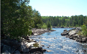
Enlarge Figure 11: Shallow rapids on the Turtle River at the inflow to Elsie Lake
3.2 Resource Uses and Activities
3.2.1 Fisheries Resource Use
The Campus Lake Conservation Reserve lies partially within fisheries management Division 22 and partially within Division 32, with the boundary conforming to the administrative boundary between OMNR Fort Frances and Dryden Districts.
A survey of angling use on the larger lakes within the conservation reserve, including Sandford, Elsie, Mable, Campus and Fish Lakes, was conducted in 2000. Boats were counted on the lakes over the period from May through September on sixteen days including both weekends and weekdays. The results showed a significant variation in use between lakes and seasonally. Although use was not consistently high, as one might expect for such a remote location, as many as 10 boats were observed on some of the lakes on a given day. Generally, the use on the largest lake within the conservation reserve, Sandford, was highest in early spring, little summer use and with some increased use towards the fall. By contrast, the smaller lakes surveyed, notably Campus and Elsie, showed greatest use in June, as users switched to these lakes from Sandford. The majority of the users are assumed to be guests of the tourist facility on Sandford Lake and the few cottagers in the area, due to access limitations. Some incidental use may be attributed to canoe parties passing through the area. Little information is available on winter angler use, although there is evidence of modest ice fishing on the lakes within the reserve.
No commercial fishing for human consumption exists within the conservation reserve. The conservation reserve contains portions of commercial baitfish blocks 492913, 492914, 493913, AT04, AT05 and AT15. No facilities associated directly with these areas exist within the conservation reserve. Existing trails within the conservation reserve are used by bait fishermen within the baitfish blocks for accessing minnow traps, as well as rudimentary trails maintained expressly for this purpose.
3.2.2 Forest Resource Use
The conservation reserve once comprised portions of the three adjacent Sustainable Forest License (SFL) areas: the Sapawe Forest, the English River Forest and the Wabigoon Forest. Amendments to the three sustainable forest licenses removed these portions from the licensed areas as part pf the regulation process for the conservation reserve.
Interim protection measures were implemented in 1999 prior to regulation to ensure that no further road development or harvesting took place. Some relatively recent harvesting had taken place within the boundaries of what is now the conservation reserve, prior to implementing interim protection, confined to relatively small areas between Fish Lake and Owl Lake south of Campus Creek, and to the north of Campus Lake along the boundary of the site, on the English River Forest. Tertiary forest access roads enter the reserve to the south of Bentarm Lake and to the northeast of Campus Lake and Campus Creek, but these have not been maintained and the limited access that this represents is deteriorating over time. All harvested areas in these locations have received regeneration treatments. Tending of the developing forest regeneration was originally intended, but a decision has been made, in consultation with the former licensee, to allow these areas to develop naturally from this point on.
All other areas that have been subject to past logging activity within the conservation reserve are approximately fifty years old at this time and no evidence of such disturbance is readily apparent. The exception would be the remnant river drive structures mentioned earlier.
3.2.3 Water Resource Use
Apart from the past use of the waters of the conservation reserve for log driving, neither currently functional dams nor other water-control structures are maintained on the system, nor are there power generation facilities.
Commercial wild rice harvesting currently does not occur within this conservation reserve, nor have any stands been identified.
3.2.4 Wildlife Resource Use
The Campus Lake Conservation Reserve lies entirely within Wildlife Management Unit 12A.
Hunting activity currently taking place specifically within the conservation reserve is largely confined to big game hunting by guests of the lodge on Sandford Lake.
Wildlife viewing is possible in a variety of habitats by canoe parties passing through the area on the rivers, lakes and portages. It is believed that such activity is currently incidental to other activities taking place within the reserve such as cottaging, canoeing, fishing or hunting.
The conservation reserve contains portions of trap lines IG50, IG57, AT46 and AT47. Three trap line cabins associated with IG50, AT46 and AT47 are located within the boundaries of the reserve. Existing trails within the conservation reserve are used by trappers within the trap line areas for accessing trap sets, as well as rudimentary trails maintained expressly for this purpose. The site also contains portions of Bear Management Areas (BMA's) IG-12A-02, IG-12A-09, AT-12B-010, AT-12A-019, AT-12A-020 and a small portion of AT-12A-022. No facilities associated directly with BMA's exist within the conservation reserve.
3.2.5 Recreational and Tourism Use
Recreational fishing within the conservation reserve has already been discussed under section 3.2.1.
No direct road access to the conservation reserve currently exists. Access to the conservation reserve is principally by floatplane, or by water and portage. Recreational use of the area is therefore relatively low in comparison to more accessible surrounding areas of comparable size and attributes.
The conservation reserve contains one main base commercial tourism lodge on Sandford Lake, and one outpost cabin on Halfmoon Lake. A second lodge once operated on Sandford Lake but is now used as a private camp. The operating lodge consists of a main lodge and individual guest cabins capable of accommodating up to 40 guests. This facility does not currently operate during the winter months. Guests are flown into the site by floatplane. The commercial operator who has tenure to the outpost cabin on Halfmoon Lake currently employs a voluntary policy of allowing guests to eat fish caught while staying at the cabin, but no fish are flown out upon leaving in order to limit consumption of the resource. Although catering to fishing parties through most of the season, the tourist facilities also operate in the fall to accommodate hunters. The lodge on Sandford Lake also promotes nature appreciation and other non-consumptive uses by prospective guests, as well as family-oriented activities. However, hunting and fishing remain the primary pursuits of guests at this time.
Figure 12: Tourist lodge on Sandford Lake.
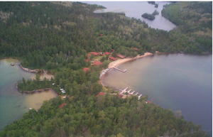
Enlarge Figure 12: Tourist lodge on Sandford Lake
The six Bear Management Areas that overlap the conservation reserve are active and represent the means by which the hunting of bears on Crown land by non-resident clients of commercial outfitters is managed.
A portion of the conservation reserve falls within a designated "green zone" area that places some restriction on the use of Crown lands by non-residents. Section 4.2.7 provides further information regarding these restrictions.
There are a total of six private camps or cottages on the lakes within the conservation reserve, used primarily during the summer. Cottagers gain access primarily by floatplane.
Although not part of a formally designated canoe route within the district, a route does exist, with well-used portages, forming a loop through the conservation reserve from the adjacent Turtle River-White Otter Lake Provincial Park. The Ann Bay portage provides access from Ann Bay on White Otter Lake to Sandford Lake to the east, then the route follows Sandford Lake north to Mable Lake, south on Mable Lake to Elsie Lake, north on Elsie Lake to Halfmoon Lake, south on Halfmoon and down the Turtle River back to Ann Bay. There are rapids between Sandford and Mable, Mable and Elsie and Elsie and Halfmoon Lakes requiring portaging. None of the portages within the conservation reserve are maintained, apart from users. Portages also exist within the conservation reserve connecting Campus Lake to Elsie Lake, Sandford Lake to Irene Lake to the east of the conservation reserve, and Sandford Lake to Wasp Lake and the Gamble River south of the reserve. Boat caches do not exist within the southern portions of the conservation reserve; however, lakes within the northern portions of the reserve are in accordance with MNR's boat cache policies. (Refer to discussion under Section 4.0)
Figure 13: Portage trail between Halfmoon and Elsie Lakes.
Enlarge Figure 13: Portage trail between Halfmoon and Elsie Lake
The area does possess a significant number of excellent swimming and bathing beaches. Although much of the shoreline of the lakes within the reserve is rock, boulders or cobble, sand beaches do exist on Sandford, Mable, Campus, Elsie and Halfmoon Lakes. No formally designated campsites exist on lakes within the reserve, but informal and well-used sites exist throughout along the course of the Turtle River. (Refer to Map 2 in Appendices).
Figure 14: Sand beaches at the north end of Irene Bay, Sandford Lake.
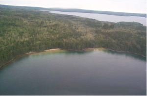
Enlarge Figure 14: Sand beaches at the north end of Irene Bay, Sandford Lake
A portion of the sanctioned provincial snow machine trail network passes through the conservation reserve, connecting the communities of Atikokan to the south with Ignace to the north. This trail (D114A) is maintained and groomed co-operatively by the snowmobile clubs in the two communities. The original route passed over the frozen waters of Sandford, Mable and Campus Lakes, then across the wetlands to the north. During consultation associated with the preparation of this plan a proposal was received from the two clubs to move the trail onto land, citing safety and liability concerns associated with unreliable ice conditions on the lakes, with the proposed route to follow the existing hydro transmission line trail between Elsie, Mable and Campus Lakes. Most users of the trail employ it on an excursion basis for traveling between the communities, rather than a means to access the conservation reserve itself. A second trail (D115A) passes north south through Turtle River-White Otter Lake Provincial Park to the west and is used primarily to provide winter access to the White Otter Castle in winter from the north and the south. Permits from the respective clubs are required to use the groomed trails in winter.
No quantitative information exists regarding the level of recreational use of the conservation reserve, apart from the boat survey information discussed under section 3.2.1. Given the lack of road access to the site, the primary users are guests of the tourist facilities and the few cottagers in the area. The amount of use by canoeists is not known, however the condition of portage trails within the site suggests that use is higher than might be expected given that the area is not on a major canoe route.
One of the reasons for proposing the site as a conservation reserve was recognition of the excellent potential of the area, in conjunction with Turtle River-White Otter Lake Provincial Park, for eco-tourism and backcountry camping activities. Although some use of the area for such non-consumptive uses presently occurs, the true potential is not yet realized, with hunting and fishing remaining the primary recreational pursuits. Both commercial and non-commercial use of the area for activities such as wildlife viewing, nature study and appreciation or more traditional pursuits such as hiking, camping, canoeing and swimming, all within a remote, natural setting have yet to be fully explored.
4.0 Management Objectives, Guidelines and Policies
The objectives in preparing this Resource Management Plan are as follows:
- To describe the planning area in terms of its ecological, cultural, economic and recreational resources. More specifically, geospatial databases will be prepared to include:
- earth and life science features such as bedrock and surficial geological features and ecological and vegetation types, as well as discrete features such as nesting sites and the locations of rare plant species where known;
- cultural heritage features, such as archeological sites;
- tourist establishments and other commercial facilities and activities such as trap lines, baitfish blocks and bear management areas and cabins;
- recreational features such as points of interest, trails and portages, campsites and beaches.
- To describe the current levels of activities and/or uses of the planning area and projected future demands. More specifically, the area will be described in terms of the types of recreational and commercial uses currently existing, including hunting, fishing, camping, canoeing and others. Additionally, potential for future development or uses such as eco-tourism will be identified where they may exist.
- To assess the role of the area in relation to the surrounding landscape, including the adjacent Turtle River - White Otter Lake Provincial Park and White Otter Enhanced Management Area. More specifically, to ensure that the goals, objectives and management direction for the area are consistent with those of the adjacent Provincial Park and plans through consultation with Ontario Parks staff.
- To provide recommendations for management of the area and permitted uses within the framework provided by existing provincial policy. More specifically, to ensure that all stakeholders and other interested parties are provided with the opportunity to participate in the preparation of the planning documents and potentially influence the management direction for the area.
- To ensure that other resource management plans and policies for the surrounding areas recognize the planning direction of the Campus Lake Conservation Reserve Resource Management Plan. More specifically, to ensure that the goals, objectives and management direction for the area are consistent with those of the adjacent Sustainable Forest License areas: the Sapawe Forest, the English River Forest and the Wabigoon Forest, through consultation with the planning bodies for those areas.
- To establish a process for maintaining and updating the plans, as required. More specifically, to identify any further study or information needs associated with the planning area which would assist in future planning, and determine appropriate periods for periodic plan review in order to ensure that management direction remains current into the future.
4.1 Land Use Direction
Six principal policy documents have outlined principles for management of conservation reserves, and remote or resource-based tourism values. These principles will be reflected in the planning process and plan documents that will be applied to the Campus Lake Conservation Reserve. The applicable policy documents are:
- Ontario’s Living Legacy Land Use Strategy (OMNR, 1999a)
- District Land Use Guidelines (OMNR, 1983a and 1983b)
- Ontario’s Approach To Wilderness: A Policy (OMNR, 1997b)
- Resource-based Tourism Policy (OMNR, 1997c)
- Conservation Reserves Policy And Procedure (OMNR, 1997a)
- MNR's Crown Land Use Policy Atlas (OMNR, 2003a)
The intent is to protect the identified values of the conservation reserve through the application of management guidelines for existing and potential uses in this area. Uses and activities which are permitted, not permitted or conditionally permitted are also governed by the policies applying to conservation reserves as stated. Any new uses, and commercial activities associated with them, will be considered on a case-by-case basis, and must pass a test of compatibility (see Appendix A) to be acceptable. Compatibility is normally determined through a planning process. The policies outlined in this resource management plan do not supersede any Aboriginal or treaty rights that may exist, or other legal obligations.
Specific policies and implementation measures applicable to the conservation reserve are described for uses associated with commercial activities, land and resource management activities and recreational activities and facilities, which follow.
4.2 Commercial Activities
Most commercial activities previously occurring within the conservation reserve will be allowed to continue, with the exception of forest management activities. No mining or hydroelectric development has occurred or is permitted, within the site. Some activities may be subject to stricter controls or limits in order to protect the values of the conservation reserve.
4.2.1 Aggregate Extraction
Management Direction: Aggregate extraction is not permitted within the conservation reserve.
No aggregate pits currently exist within the conservation reserve.
4.2.2 Commercial Bait fishing
Management Direction: Existing use permitted to continue, unless significant demonstrated conflicts arise. New operations can be considered, subject to the "test of compatibility".
Currently the entire area is under license and therefore no new operations are anticipated. Changes in licensees are not considered new operations and will be subject to the provincial policies governing such transfers. Existing roads and trails may continue to be used for access purposes.
4.2.3 Commercial Fishing
Management Direction: New operations can be considered, subject to the "test of compatibility".
No commercial food fisheries currently exist within the conservation reserve. Although new operations can be considered, this will be subject to the strategies contained within the district Fisheries Management Plans and take into account the sustainability of the fisheries resource.
4.2.4 Commercial Fur Harvesting
Management Direction: Existing use permitted to continue, unless significant demonstrated conflicts arise. Existing trap cabins can continue; new cabins are not permitted. New operations can be considered, subject to the "test of compatibility".
The entire area is currently under license. Changes in licensees are not considered new operations and will be subject to the provincial policies governing such transfers. Existing roads and trails may continue to be used for access purposes. There are currently three trap cabins within the conservation reserve and these may continue to be used.
4.2.5 Commercial Hydro Development
Management Direction: Commercial hydro development is not permitted within the conservation reserve.
There are no existing facilities within the site.
4.2.6 Commercial Timber Harvest and Forest Operations
Management Direction: Commercial timber harvesting and forestry operations are not permitted within the conservation reserve.
Operations within those portions of the conservation reserve subject to harvesting prior to Ontario’s Living Legacy have been regenerated and no further operations are planned or permitted. Logging roads and trails will be allowed to continue to deteriorate naturally. No water crossings associated with such roads exist within the conservation reserve.
4.2.7 Commercial Tourism
Management Direction: Existing authorized facilities can continue, unless significant demonstrated conflicts arise. New tourism facilities can be considered through an amendment to this Resource Management Plan.
- Bear Hunting by Non-residents (guided): Existing authorized operations permitted to continue. New operations not permitted.
- Outfitting Services: Existing authorized operations permitted to continue. New operations can be considered subject to planning and amendment.
- Outpost camp: Existing authorized operations permitted to continue. New operations can be considered subject to planning and amendment.
- Resorts/lodges: Existing authorized facilities permitted to continue. New facilities can be considered subject to planning and amendment.
The existing main base lodge on Sandford Lake and outpost cabin on Halfmoon Lake will continue to operate. Any proposals for new or expanded facilities will take into account the potential impact on the fisheries and other resources.
The development of the area’s potential for eco-tourism and other non-consumptive tourism activities will be encouraged.
A portion of the conservation reserve falls within a designated "green zone" area that places some restriction on the use of Crown lands by non-residents. This zone, regulated area under the Public Lands Act, includes the area surrounding Halfmoon Lake and the Turtle River to the south on the western side of the conservation reserve. Camping on Crown land by non-residents of Canada is not permitted. Non-residents may use the regulated area for day use only. Overnight accommodations must be at a registered tourist accommodation facility. Camping by non-residents outside this zone on Crown land within the area requires a valid Crown land camping permit, or rental of camping unit from a registered Ontario tourist outfitter. Further information regarding non-resident Crown land camping may be obtained by contacting the MNR offices in Ignace or Atikokan.
The entire conservation reserve is comprised of portions of Bear Management Areas.
4.2.8 Energy Transmission and Communications Corridors
Management Direction: Existing corridors may continue to be used. New facilities should avoid conservation reserve lands wherever possible.
One double line hydro transmission corridor passes through the conservation reserve from north to south. The use of manual or mechanical line clearing techniques will be encouraged. The use of the existing access trail along this line will be permitted to continue. Disturbance of the weir and remnant sluice at the outlet of Mable Lake is not permitted.
4.2.9 Food Harvesting (Commercial)
Management Direction: Written authority required.
Commercial food harvesting, such as berry picking, will be considered subject to the "test of compatibility". Such proposals will be directed to surrounding non-conservation reserve lands wherever possible.
4.2.10 Mineral Exploration and Development
Management Direction: Mineral exploration and development are not permitted within the conservation reserve.
No such activities have previously occurred within the conservation reserve.
4.2.11 Commercial Peat Extraction
Management Direction: Commercial peat extraction is not permitted within the conservation reserve.
Any proposals for commercial peat extraction will be directed to areas outside of the conservation reserve.
4.2.12 Commercial Wild Rice Harvesting
Management Direction: New operations will be subject to the "test of compatibility".
No known significant wild rice stands exist within the conservation reserve, nor are any known commercial operations taking place at this time.
4.2.13 Other Commercial Activities
Management Direction: New proposals for commercial activities may be considered on a case-by-case basis subject to the "test of compatibility" and may require planning and an amendment to this resource management plan.
Should new proposals for activities not currently occurring on the conservation reserve be received, such as proposals associated with ecotourism, these will be considered within the broad framework of all current policies and potential impacts on the values of the site. Planning for any new activities will involve public consultation and any requirements under the Environmental Assessment Act.
4.3 Land and Resource Management Activities
Management of the conservation reserve is carried out within the context of policy documents applying specifically to conservation reserves such as the Land Use Strategy, Conservation Reserves Policy and the Crown Land Use Policy Atlas, as well as policies that apply more broadly, such as those governing the management of fish and wildlife resources.
4.3.1 Crown Land Disposition
Management Direction: Sale of lands is not permitted, except for minor dispositions in support of existing uses (e.g., reconstruction of a septic system). Renewals of existing leases and land use permits are permitted. Requests for transfer of tenure may be considered in the context of the direction contained in this resource management plan. New leases or land use permits may be permitted for approved activities. Tourism facilities can apply to upgrade tenure from LUP to lease.
The rationale behind potentially allowing sale of small amounts of land to upgrade or reconstruct a septic system is that the beneficial effects on the conservation reserve of a more effective septic system outweigh the limited detrimental effects of disposing of small parcels. This scenario only applies to adjacent patented properties within the reserve, of which there are few.
4.3.2 Fire Suppression
Management Direction: Fire suppression policies are similar to adjacent Crown lands, unless alternative fire policies have been developed through a planning process.
The MNR recognizes fire as an essential process fundamental to the ecological integrity of conservation reserves. In accordance with existing Conservation Reserve Policy and the Forest Fire Management Strategy for Ontario, forest fire protection will be carried out as on surrounding lands.
Whenever feasible, the MNR fire program will endeavour to use "light on the land" techniques, which do not unduly disturb the landscape, in this conservation reserve. Examples of light on the land techniques may include limiting the use of heavy equipment or limiting the number of trees felled during fire response efforts.
4.3.3 Fish Habitat Management
Management Direction: Fish habitat management may be permitted.
Fish habitat management, where desirable, such as spawning bed rehabilitation or enhancement, may be undertaken subject to the District Fisheries Management Plans and fulfilling any requirements under the Environmental Assessment Act.
4.3.4 Fish Stocking
Management Direction: Conservation Reserves policy indicates that "featured species management" may be permitted.
Fish stocking, where desirable, may be undertaken subject to the District Fisheries Management Plans and fulfilling any requirements under the Environmental Assessment Act.
4.3.5 Insect/disease Suppression
Management Direction: Insect or disease suppression may be permitted.
Outbreaks of insect infestations or disease considered detrimental to the values of the conservation reserve or surrounding lands may be suppressed where necessary. Techniques employed will favour biological control measures wherever feasible over alternatives. Control of non-native species will be considered a priority.
4.3.6 Inventory/Monitoring
Management Direction: Inventory and monitoring of the values and uses of the conservation reserve are permitted.
Ongoing monitoring of the health and status of the natural values and level of uses within the conservation reserve are essential to management. Such activities include monitoring of compliance with the regulations and policies applicable to the reserve. Additionally, updating and maintaining the earth science, life science and recreational inventories for the site as time and resources allow is desirable.
4.3.7 Prescribed Burning
Management Direction: The use of prescribed burning or prescribed natural fire may be permitted.
Opportunities for prescribed burning to achieve ecological or resource management objectives may be considered. These management objectives will be developed with public consultation prior to any prescribed burning, and reflected in the resource management plan. Plans for any prescribed burning will be developed in accordance with the MNR Prescribed Burn Planning Manual, and the Class Environmental Assessment for Provincial Parks and Conservation Reserves.
4.3.8 Road Development and Maintenance
Management Direction: Existing roads can continue to be used. New roads for resource extraction will not be permitted, except where prior agreement under the provisions of the Ontario Forest Accord takes precedence.
The Sustainable Forest License holder for the area surrounding the southern portions of the conservation reserve identified the need to access the area to the east of Sandford Lake by passing through a narrow gap between Sandford and Wasp Lakes. The topography in this location dictates that the required road must pass through a portion of the conservation reserve in this location, for a distance of approximately half of a kilometre. If future forest management planning indicates that no suitable alternative exists, this use is permitted under the terms of the Forest Accord. However, the conditions that will apply include keeping the road to the minimum standard necessary, including keeping the right-of-way to a minimum width. Additionally the road is to be kept as far from Sandford Lake as possible and the buffer between the road and the lake is to be kept in an undisturbed state. Public access restrictions will also apply. Measures are also to be taken to maintain the utility and safe use of the portage that crosses the proposed route, connecting Sandford and Wasp Lakes. Finally, upon completion of forest operations, the road is to be physically removed and rehabilitated. These measures are to be incorporated into the road use strategy in the Forest Management Plan for the area. This is the only new road to be permitted within the conservation reserve.
All other pre-existing roads are no longer required for forest management purposes and will not be maintained, but will be allowed to deteriorate and re-vegetate naturally.
4.3.9 Vegetation Management
Management Direction: Conservation Reserves policy indicates that Featured Species Management and Natural Systems Management may be permitted. Vegetation management can be considered in a planning process and may require an amendment to this resource management plan.
Where vegetation management is considered necessary or desirable, more natural measures such as the use of prescribed burning will be favoured over artificial means wherever available and possible. The use of herbicides in vegetation management within the conservation reserve will be discouraged. Control of non-native species will be considered a priority.
4.4 Science, Education and Heritage Appreciation
The Campus Lake Conservation Reserve contains features that may hold interest for amateur and professional naturalists. There is the potential for a number of low impact, non-consumptive recreational activities such as wildlife viewing and photography, although access difficulties are expected to continue to limit use, especially within the large wetland portions of the site.
4.4.1 Collecting
Management Direction: Collecting within the conservation reserve is not permitted.
The only exception to this applies to those granted a valid scientific collection permit for the site and those licensed under the Ontario Heritage Act.
4.4.2 Historical Appreciation
Management Direction: Permitted.
This non-consumptive, "low impact" type of activity is encouraged. Users are reminded that collection is not permitted and heritage and archaeological sites are not to be disturbed. The location and specific details regarding some cultural heritage resources may be kept confidential in order to ensure protection of such values and sites.
4.4.3 Nature Appreciation
Management Direction: Permitted.
This non-consumptive, "low impact" type of activity is encouraged.
4.4.4 Photography and Painting
Management Direction: Permitted.
This non-consumptive, "low impact" type of activity is encouraged.
4.4.5 Research
Management Direction: Permitted.
Approved research activities, which do not detrimentally affect the values, which the conservation reserve is, designed to protect, will be encouraged. Potential research projects may include monitoring of the succession in the vegetation within disturbed and undisturbed portions of the site. Further, more detailed surveys and documentation of the wetland site types and species would be desirable. Refer to comments under Section 4.4.1.
4.4.6 Wildlife Viewing
Management Direction: Permitted.
This non-consumptive, "low impact" type of activity is encouraged.
4.5 Recreational Activities and Facilities
Normal application of controls such as quotas and seasons are designed to ensure that fish and wildlife populations remain sustainable. Use of existing trails can be allowed to continue. Proposals for the development of new trails to permit access for these activities will be considered carefully to ensure that the values of the conservation reserve are protected. New trails within the wetland features will be discouraged. Recreational hunting will be permitted, although it is expected that access limitations and the mature forest will limit the level of use.
4.5.1 All Terrain Vehicle Use
Management Direction: Existing use on trails is permitted to continue where it does not adversely affect the values being protected. ATV use off trails is not permitted except for direct retrieval of game.
Existing trails are shown on maps contained within the appendices, with the exception of those trails used to access trap lines and baitfish blocks. Trappers and bait fishermen are permitted to use their trails to access their trap sets.
4.5.2 Campgrounds
Management Direction: The development of new campgrounds is not permitted.
The use of existing campsites is permitted. Permanent structures are not permitted without prior approval. New campground proposals will not be permitted within the conservation reserve.
4.5.3 Food Gathering
Management Direction: Permitted.
The gathering of edible materials such as berries for personal consumption is permitted.
4.5.4 Horseback Riding (trail)
Management Direction: Existing use on trails permitted.
The conservation reserve does provide some opportunities for trail riding, although some sections of trail may be grown-in or too wet for this purpose.
4.5.5 Hunting
Management Direction: Permitted.
The regulations under the Fish and Wildlife Conservation Act apply.
4.5.6 Mountain Bike Use
Management Direction: Existing use on trails permitted.
The conservation reserve does provide some opportunities for mountain biking on trails, although not all trails may be passable by this means.
4.5.7 Motor Boat Use
Management Direction: Traditional use of motor boats is permitted.
Authority to cache commercial and private boats is required within that portion of the conservation reserve within the Dryden Administrative District (refer to Map 1 in the appendices). Boat cache authority is not required within that portion of the conservation reserve lying within the Fort Frances Administrative District. Users are advised to check with local MNR offices to verify requirements.
Existing boat cache authority (commercial tourism, resource user, recreation) is permitted to continue, unless there are significant demonstrated conflicts. New commercial tourism boat cache authority may be permitted through an amendment to the Resource Management Plan. Resource user and private recreation boat caches may be permitted subject to the “test of compatibility”.
4.5.8 Non-motorized Recreational Travel
Management Direction: Permitted.
The conservation reserve does provide some opportunities for backpacking and hiking, both on and off trails.
4.5.9 Private Recreational Camps
Management Direction: No new private recreation camps are permitted.
No private recreation camps (i.e. hunt camps) exist within the conservation reserve.
4.5.10 Rock Climbing
Management Direction: Rock climbing may be permitted within the conservation reserve.
Some cliffs exist at locations within the conservation reserve that are sufficiently high to offer limited potential opportunities for rock climbing. Utilization of equipment or techniques that damage or deface these features is not permitted.
4.5.11 Snowmobiling
Management Direction: Existing use permitted to continue where it does not adversely affect the values being protected. Snowmobiling use off of trails is not permitted, except that snowmobiles may be used for direct retrieval of game.
The use of the frozen surfaces of lakes within the conservation reserve is permitted for travel by snow machine, although users are cautioned to ensure that ice conditions are safe for doing so. Elsewhere, travel is restricted to the use of existing trails, including portages. Trappers and commercial bait fishermen are permitted use of snow machines on their trails to access their traps.
The use of the trails groomed by the snowmobile clubs in Ignace and Atikokan that form part of the provincial trail system running through the conservation reserve require the purchase of a trail permit. The clubs are currently in the process of relocating that trail off Sandford, Mable and Campus Lakes to the hydro access trail that follows the transmission corridor through the reserve.
4.5.12 Sport Fishing
Management Direction: Permitted.
The regulations under the Fish and Wildlife Conservation Act apply. Excellent angling opportunities for lake trout, northern pike and smallmouth bass exist within the reserve.
4.5.13 Trail Development
Management Direction: Development of trails for a variety of activities (e.g., hiking, cross-country skiing, cycling, horseback riding, and snowmobiling) can be considered through a planning process.
The proposal by the snow machine clubs in Ignace and Atikokan to relocate the existing provincially sanctioned snow machine trail running through the reserve to a new location using the existing upland trail following the hydro transmission corridor has been subject to public consultation during the preparation of this plan. The rationale behind the proposal was that unsafe or unreliable ice conditions on the lakes that the trail originally followed created safety and liability issues that the upland route would avoid. Alternative routes were considered for this relocated trail in addition to the route proposed by the proponents. Other alternatives all involved cutting of new trail. Given that public response was largely supportive or neutral in respect of the original proposal, that other upland alternatives involved greater impacts on the natural environment and that no specific issues were identified with the proposed new route, the intent is that the proposal will be accepted upon approval of this plan. That approval of the new route is contingent upon the clubs obtaining the necessary permission from the utility company to use portions of their right-of-way. Additional conditions that apply are that no disturbance of the weir or sluiceway at the outlet of Mable Lake occurs, that no new trail will be constructed without prior written approval and potential further public consultation, and that maintenance within the reserve be confined to the existing trail and includes packing, brushing and removal of obstacles such as wind thrown trees. Signage for safety purposes is permitted.
Proposals by any other individual, group or organization for new trail development within the conservation reserve will require approval and are subject to a similar planning process and the "test of compatibility".
5.0 Implementation
The Atikokan Area of the Fort Frances Ministry of Natural Resources District and the Ignace Area of the Dryden Ministry of Natural Resources District will be responsible for implementing the management policies and guidelines for the area. The Fort Frances District will assume the lead role in planning matters in consultation with Dryden District. All MNR resource management plans or land use documents have been revised as necessary to exclude timber harvesting and other non-permitted activities from the conservation reserve. All stakeholders and clients have been informed through mail and media notices of the changes that have taken affect in respect of the site. Ongoing consultation between Area staff of MNR responsible for management of the conservation reserve and Ontario Parks staff associated with the adjacent Turtle River- White Otter Lake Provincial Park is imperative to ensure that policies and practices are complimentary.
Much of the forest within the conservation reserve is of an advanced age. Some upland forest types, particularly those with a significant pine component, rely upon cyclical wildfire to maintain themselves. Sustaining these values in the long-term may require development of a vegetation management plan and natural disturbance strategy.
Further, more detailed surveys of the earth science, life science, cultural heritage and other values of the conservation reserve are desirable as time and resources allow.
During the logging period in the White Otter area, various water control structures were constructed along the Turtle River designed to raise water levels to aid in the movement of logs. Most of these structures within the conservation reserve were in the form of boulder and timber weirs. Although remnants of these structures still exist today, they have largely deteriorated over the years to the point where they have only marginal influence on lake levels. Removal of such structures is not proposed. Additionally, these remnant structures are considered cultural heritage sites, providing some insight into the area’s history.
No marketing associated specifically with this conservation reserve for tourism and recreational purposes is planned at this time. No on-site facilities or client services exist within the conservation reserve, nor are any proposed at this time. Users are responsible for removal and proper disposal of all garbage and waste materials. No maintenance of trails or portages is currently carried out or proposed.
6.0 Plan Maintenance, Review and Revisions
The policies that form the basis of this resource management plan are specified in the approved Ontario’s Living Legacy Land Use Strategy. A policy statement defining the land use intent and specific policies applicable to this conservation reserve may also be found posted on the internet as part of the Crown Land Use Policy Atlas. Should revisions to the policies applying to this conservation reserve be required over time, such revisions will be subject to the provisions of the Land Use Strategy regarding amendments.
The Campus Lake Conservation Reserve Resource Management Plan will be revised as needed in accordance with any new information or policy direction. Revisions to the resource management plan will be subject to the requirements as specified in the Class Environmental Assessment for Provincial Parks and Conservation Reserves. Significant changes as defined under the Class EA will involve a public consultation process and approval from the District Manager and Regional Director of the Ministry of Natural Resources.
7.0 Public Consultation
7.1 Past Consultation
The Campus Lake Conservation Reserve was included amongst the proposed protected areas subject to the consultation process throughout the Lands for Life/Ontario’s Living Legacy land use planning exercise. Consultation associated with the land use planning initiative occurred at a number of stages in the process:
- Lands For Life round table consultations June 1997-July 1998
- Ontario’s Living Legacy Land Use Strategy consultations 1999
- OLL Site Regulation Public Consultation Process 2000.
Further information on past consultation is available from MNR offices in Fort Frances, Dryden, Ignace and Atikokan.
7.2 Present and Future Consultation
Public notification and consultation was undertaken for the preparation of this document to meet MNR's policy requirements with respect to the preparation of resource management plans as identified in the policy document A Framework For Resource Management Planning In MNR (1986). Consultation was also conducted for the preparation of the Management Guideline for the adjacent White Otter Enhanced Management Area in conjunction with that associated with the preparation of the Resource Management Plan for the Campus Lake Conservation Reserve. The purpose of this consultation was to provide an opportunity for public participation in the specific measures to be taken in implementing the policies of the Land Use Strategy as they applied to the area, in particular those relating to access.
Consultation during the preparation of the management plan occurred at various stages throughout the planning process:
- Invitation to Participate - March 6 to April 4, 2003
- Review of Management Options - July 14 to August 28, 2003
- Review of the Draft Resource Management Plan (internal MNR) – March 2004 to May 2005
- EBR Posting for the Draft Resource Management Plan – July 14, 2003 to September 05, 2003
- EBR Posting for the Final Resource Management Plan
Notices of opportunities included newspaper advertisements placed in local news media, posting on the Environmental Bill of Rights website and direct mail notification. Those contacted directly by mail included identified stakeholders, interest groups, aboriginal and treaty organizations, government organizations and individuals with a known interest in the area. Information centres were held in Ignace on March 19 and July 30, 2003 and in Atikokan on March 20 and July 31, 2003.
Comments received included:
- Eleven that indicated support for the snow machine trail relocation, three that were neutral on the issue and one that did not support the proposal, although the latter respondent gave no specific rationale beyond a desire for things to remain as they were.
- Five comments were received indicating support for the creation of the protected area and expressing appreciation for the beauty of the area.
- Two comments were received expressing the view that there were too many protected areas.
- Three individuals expressed the opinion that greater enforcement was required in the protected areas.
- Three respondents stressed the need to allow continued use of trails within the area by commercial bait fishermen and trappers.
- A forest licensee operating in the adjacent area re-iterated an earlier concern expressed during the Living Legacy process and carried forward to the Forest Accord Board, that access to the area lying to the immediate east of the conservation reserve required that a road be constructed through a portion of the conservation reserve at the extreme southern tip, between Wasp and Sandford Lakes. This proposal was considered the only viable alternative for accessing the area in question.
- Some respondents were primarily interested in reviewing the material and obtaining further information.
Input received throughout the planning process was taken into consideration in decision-making and is reflected in the direction contained within this management plan. The results of the public consultation are summarized in the table contained in Appendix F. One issue that was addressed through the consultation process was a proposal to utilize the existing hydro transmission corridor access trail within the conservation reserve as an alternative to the existing water route forming part of the provincial TOPS snowmobile trail system.
More detailed Consultation Documentation is available on file at the Fort Frances and Dryden District offices of the Ministry of Natural Resources.
8.0 References
Barnett, P.J., Henry, A.P. and Babuin, D., 1991: Quaternary Geology of Ontario, West Central Sheet. Ontario Geological Survey. Map 2554. scale 1:1,000,000.
Baycroft, R., 2001. Campus Lake Conservation Reserve Recreation Inventory Checklist. Ontario Ministry of Natural Resources, Fort Frances District. unpublished report. 1 p. + attachments.
Burger, D., 1993. Revised Site Regions of Ontario: Concepts, Methodology and Utility. Ont. For. Res. Institute. Sault Ste. Marie, Ont. For. Res. Rep. No. 129. 24 pp.
Cowell, D.W., 2000. Campus Lake Conservation Reserve Earth Science Checksheet. North-South Environmental Inc. 6 p. + Map.
CCRS, 1999. Canada Land Inventory Classification for Recreation. The Canadian Centre for Remote Sensing, Natural Resources Canada. Ottawa.
Hills, G.A., 1961. The Ecological Basis for Land-Use Planning. Ont. Dept. Lands and Forests. Toronto, Ont. Res. Rep. No. 42. 63 pp.
Mollard, D. G., 1980. Gulliver River Area (NTS 52G/SW), District of Kenora: Ontario Geological Survey, Northern Ontario Geology Terrain Study 39, 14 p. Accompanied by Map 5064, scale 1:100,000.
NHIC, 2003. Natural Heritage Information Centre Database. Ontario Ministry of Natural Resources. Page.<http://mnrweb.mnr.gov.on.ca/nhic/nhic.cfm>. Accessed 2003, December.
OAS, 2003. The Archaeology of Ontario. Ontario Archaeological Society. Page: <http://www.ontarioarchaeology.on.ca/>. Accessed December, 2003. (after original text by Jeff Bursey, Hugh Daechsel, Andrew Hinshelwood and Carl Murphy: Discovering Ontario Archaeology: Speakers Kit.).
Ontario Geological Survey, 1991. Bedrock Geology of Ontario., West Central Sheet. Ontario Geological Survey. Map 2542. scale 1:1,000,000.
OMNR, 1977. A Ready Reference: Ontario Land Inventory (draft). Ontario Ministry of Natural Resources. unpublished. 75 pp.
OMNR, 1981?. Atikokan Land Use Plan: Background Information. Ontario Ministry of Natural Resources. Toronto, Ont. 76 pp.
OMNR, 1983a. Atikokan District Land Use Guidelines. Ontario Ministry of Natural Resources. Toronto, Ont. 75 pp. + map.
OMNR, 1983b. Ignace District Land Use Guidelines. Ontario Ministry of Natural Resources. Toronto, Ont. 74 pp. + map.
OMNR, 1996. Forest Resources Inventory - Wabigoon Forest. Ontario Ministry of Natural Resources Digital G.I.S. database.
OMNR, 1997a. Conservation Reserves Policy and Procedure. Ontario Ministry of Natural Resources. PL 3.03.05.
OMNR, 1997b. Ontario’s Approach To Wilderness: A Policy. Ontario Ministry of Natural Resources. 16 pp. + appendices.
OMNR, 1997c. Resource-based Tourism Policy. Ontario Ministry of Natural Resources. 4 pp.
OMNR, 1999a. Ontario’s Living Legacy - Land Use Strategy. Ontario Ministry of Natural Resources Toronto, Ont. 136 pp.
OMNR, 1999b. Forest Resources Inventory - English River Forest. Ontario Ministry of Natural Resources Digital G.I.S. database.
OMNR, 2000a. Forest Resources Inventory - Sapawe Forest. Ontario Ministry of Natural Resources Digital G.I.S. database, original 1996 inventory updated to year 2000.
OMNR, 2000b. Early White Pine Logging: Sapawe Forest. Ontario Ministry of Natural Resources. Background documentation for the 2000 Forest Management Plan. Unpublished. 7 p. + Appendices.
OMNR, 2000c. Protected Areas Regulation Implementation Manual; Ontario Ministry of Natural Resources. Internal Document.
OMNR, 2003a. Crown Land Use Policy Atlas. Ontario Ministry of Natural Resources. /page/crown-land-use-policy-atlas
OMNR, 2003b. Natural Resources Values Information System (NRVIS). Ontario Ministry of Natural Resources, Fort Frances District.
OMNR, 2003c. Campus Lake Conservation Reserve (C2299) Fact sheet. Northwest Region. Thunder Bay. 2p.
Pye, E. G. and Fenwick, K. G., 1964. Atikokan - Lakehead Sheet. Ontario Department of Mines. Geological Compilation Series, Map 2065. scale 1:253,440.
Racey, G.D., Harris, A.G., Jeglum, J.K., Foster, R.F. and Wickware, G.M., 1996. Terrestrial and Wetland Ecosites of Northwestern Ontario. Ont. Min. Natur. Resour., Northwest Sci. & Technol. Field Guide FG-02. 94 pp. + Append.
Ross, W. A., 1979. The Archaeology of North-Central Ontario: Prehistoric Cultures North of Superior. Historical Planning and Research Branch, Ontario Ministry of Culture and Recreation. 11 pp.
Rowe, J.S., 1972. Forest Regions of Canada. Dept. Environ., Can. For. Serv. Ottawa, Ont. Publ. No. 1300 172 pp.
Sims, R.A., Towill, W.D., Baldwin, K.A. and Wickware, G.M., 1989. Field Guide to the Forest Ecosystem Classification for Northwestern Ontario, Ont. Min. Natur. Resour., Northwest. Ont. For. Technol. Dev. Unit, & Technol.. 191 pp.
Springer, J., 1978. Ontario Mineral Potential, Ignace Sheet, Districts of Thunder Bay, Kenora and Rainy River. Ontario Geological Survey Prelim. Map P.1529, Mineral Deposits Ser., Scale 1:250,000
Teller, J.T., Thorleifson, L.H., Dredge, L.A., Hobbs, H.C. and Schreiner, B. T., 1983. Maximum Extent and Major Features of Lake Agassiz. in Glacial Lake Agassiz. Geological Association of Canada. Special paper 26, p. 43-45. incl. map, 1:3,000,000.
Wright, J. V., 1972. Ontario Prehistory: An Eleven Thousand Year Archaeological Outline. Archaeological Survey of Canada/Canadian Museum of Civilization. Ottawa.
Zoladeski, C., 2000. Campus Lake Conservation Reserve Life Science Checksheet. North-South Environmental Inc. 7 pp.
Zoltai, S.C., 1961. Glacial History of Part of Northwestern Ontario. Proceedings of the Geological Association of Canada, v.13, p.61-83.