Common Hoptree Recovery Strategy
This document advises the ministry on ways to ensure healthy numbers of the Common Hoptree, a threatened or endangered species, return to Ontario.
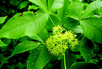
Photo: Rob Tervo
Recovery strategy prepared under the Endangered Species Act, 2007
2013
About the Ontario Recovery Strategy Series
This series presents the collection of recovery strategies that are prepared or adopted as advice to the Province of Ontario on the recommended approach to recover species at risk. The Province ensures the preparation of recovery strategies to meet its commitments to recover species at risk under the Endangered Species Act (ESA) and the Accord for the Protection of Species at Risk in Canada.
What is recovery?
Recovery of species at risk is the process by which the decline of an endangered, threatened, or extirpated species is arrested or reversed, and threats are removed or reduced to improve the likelihood of a species' persistence in the wild.
What is a recovery strategy?
Under the ESA a recovery strategy provides the best available scientific knowledge on what is required to achieve recovery of a species. A recovery strategy outlines the habitat needs and the threats to the survival and recovery of the species. It also makes recommendations on the objectives for protection and recovery, the approaches to achieve those objectives, and the area that should be considered in the development of a habitat regulation. Sections 11 to 15 of the ESA outline the required content and timelines for developing recovery strategies published in this series.
Recovery strategies are required to be prepared for endangered and threatened species within one or two years respectively of the species being added to the Species at Risk in Ontario list. There is a transition period of five years (until June 30, 2013) to develop recovery strategies for those species listed as endangered or threatened in the schedules of the ESA. Recovery strategies are required to be prepared for extirpated species only if reintroduction is considered feasible.
What’s next?
Nine months after the completion of a recovery strategy a government response statement will be published which summarizes the actions that the Government of Ontario intends to take in response to the strategy. The implementation of recovery strategies depends on the continued cooperation and actions of government agencies, individuals, communities, land users, and conservationists.
For more information
To learn more about species at risk recovery in Ontario, please visit the Ministry of Natural Resources Species at Risk webpage at: www.ontario.ca/speciesatrisk
Recommended citation
Ontario Ministry of Natural Resources. 2013. Recovery Strategy for the Common Hoptree (Ptelea trifoliata) in Ontario. Ontario Recovery Strategy Series. Ontario Ministry of Natural Resources, Peterborough, Ontario. iii + 5 pp + Appendix vi + 61 pp. Adoption of Recovery Strategy for the Common Hoptree (Ptelea trifoliata) in Canada (Parks Canada Agency 2012).
© Queen’s Printer for Ontario, 2013
ISBN 978-1-4606-0535-6 (PDF)
Content (excluding the cover illustration) may be used without permission, with appropriate credit to the source.
Cette publication hautement spécialisée Recovery strategies prepared under the Endangered Species Act, 2007, n'est disponible qu'en anglais en vertu du Règlement 411/97 qui en exempte l'application de la Loi sur les services en français. Pour obtenir de l'aide en français, veuillez communiquer avec Cathy Darevic au ministère des Richesses naturelles au
Declaration
The recovery strategy for the Common Hoptree was developed in accordance with the requirements of the Endangered Species Act, 2007 (ESA). This recovery strategy has been prepared as advice to the Government of Ontario, other responsible jurisdictions and the many different constituencies that may be involved in recovering the species.
The recovery strategy does not necessarily represent the views of all of the individuals who provided advice or contributed to its preparation, or the official positions of the organizations with which the individuals are associated.
The goals, objectives and recovery approaches identified in the strategy are based on the best available knowledge and are subject to revision as new information becomes available. Implementation of this strategy is subject to appropriations, priorities and budgetary constraints of the participating jurisdictions and organizations.
Success in the recovery of this species depends on the commitment and cooperation of many different constituencies that will be involved in implementing the directions set out in this strategy.
Responsible jurisdiction
Ontario Ministry of Natural Resources
Environment Canada – Canadian Wildlife Service, Ontario
Parks Canada Agency
Adoption of recovery strategy
The Endangered Species Act, 2007 (ESA) requires the Minister of Natural Resources to ensure recovery strategies are prepared for all species listed as endangered or threatened on the Species at Risk in Ontario (SARO) List. Under the ESA, a recovery strategy may incorporate all or part of an existing plan that relates to the species.
The Common Hoptree (Ptelea trifoliata) is listed as threatened on the SARO List. The species is also listed as threatened under the federal Species at Risk Act (SARA). Parks Canada Agency prepared the Recovery Strategy for the Common Hoptree in Canada in April, 2012 to meet its requirements under the SARA. This recovery strategy is hereby adopted under the ESA. With the additions indicated below, the enclosed strategy meets all of the content requirements outlined in the ESA.
Species assessment and classification
Common name: Common Hoptree
Scientific name: Ptelea trifoliata
SARO List Classification: Threatened SARO List History: Threatened (2004)
COSEWIC Assessment History: Threatened (2002), Special Concern (1984)
SARA Schedule 1: Threatened (January 12, 2005)
Conservation status rankings: GRANK: G5 NRANK: N3 SRANK: S3
The glossary provides definitions for technical terms, including the abbreviations above.
Area for consideration in developing a habitat regulation
Under the ESA, a recovery strategy must include a recommendation to the Minister of Natural Resources on the area that should be considered in developing a habitat regulation. A habitat regulation is a legal instrument that prescribes an area that will be protected as the habitat of the species. The recommendation provided below will be one of many sources considered by the Minister when developing the habitat regulation for this species.
Section 7 of the federal recovery strategy provides an identification of critical habitat (as defined under the SARA). Identification of critical habitat is not a component of a recovery strategy prepared under the ESA. However, it is recommended that the approach used to identify critical habitat in Section 7 be considered when developing a habitat regulation under the ESA.
Glossary
Committee on the Status of Endangered Wildlife in Canada (COSEWIC): The committee established under section 14 of the Species at Risk Act that is responsible for assessing and classifying species at risk in Canada.
Committee on the Status of Species at Risk in Ontario (COSSARO): The committee established under section 3 of the Endangered Species Act, 2007 that is responsible for assessing and classifying species at risk in Ontario.
Conservation status rank: A rank assigned to a species or ecological community that primarily conveys the degree of rarity of the species or community at the global (G), national (N) or subnational (S) level. These ranks, termed G-rank, N-rank and S-rank, are not legal designations. The conservation status of a species or ecosystem is designated by a number from 1 to 5, preceded by the letter G, N or S reflecting the appropriate geographic scale of the assessment. The numbers mean the following:
1 = critically imperilled
2 = imperilled
3 = vulnerable
4 = apparently secure
5 = secure
Endangered Species Act, 2007 (ESA): The provincial legislation that provides protection to species at risk in Ontario.
Species at Risk Act (SARA): The federal legislation that provides protection to species at risk in Canada. This act establishes Schedule 1 as the legal list of wildlife species at risk. Schedules 2 and 3 contain lists of species that at the time the Act came into force needed to be reassessed. After species on Schedule 2 and 3 are reassessed and found to be at risk, they undergo the SARA listing process to be included in Schedule 1.
Species at Risk in Ontario (SARO) List: The regulation made under section 7 of the Endangered Species Act, 2007 that provides the official status classification of species at risk in Ontario. This list was first published in 2004 as a policy and became a regulation in 2008.
Appendix 1 - Recovery Strategy for the Common Hoptree (Ptelea trifoliata) in Canada
Recovery Strategy for the Common Hoptree (Ptelea trifoliata) in Canada
2012
Recommended citation:
Parks Canada Agency. 2012. Recovery Strategy for the Common Hoptree (Ptelea trifoliata) in Canada. Species at Risk Act Recovery Strategy Series. Parks Canada Agency. Ottawa. vi + 61 pp.
For copies of the recovery strategy, or for additional information on species at risk, including COSEWIC Status Reports, residence descriptions, action plans, and other related recovery documents, please visit the Species at Risk Public Registry (www.sararegistry.gc.ca).
Cover illustration: Parks Canada Agency collection.
Également disponible en français sous le titre « Programme de rétablissement du ptéléa trifolié (Ptelea trifoliata) au Canada »
© Her Majesty the Queen in Right of Canada, represented by the Minister of the Environment, All rights reserved.
ISBN no. 978-1-100-19166-9
Catalogue no. En3-4/117-2012E-PDF
Content (excluding the illustrations) may be used without permission, with appropriate credit to the source.
Preface
The federal, provincial, and territorial government signatories under the Accord for the Protection of Species at Risk (1996) agreed to establish complementary legislation and programs that provide for effective protection of species at risk throughout Canada. Under the Species at Risk Act (S.C. 2002, c.29) (SARA), the federal competent ministers are responsible for the preparation of recovery strategies for listed Extirpated, Endangered, and Threatened species and are required to report on progress within five years.
The Minister responsible for the Parks Canada Agency and Environment Canada (the Minister of the Environment) is the competent minister for the recovery of the Common Hoptree and has prepared this strategy, as per section 37 of SARA. It has been prepared in cooperation with Caldwell, Walpole Island, and Six Nations First Nations; Ontario Ministry of Natural Resources, including Ontario Parks; Long Point Region Conservation Authority; Nature Conservancy of Canada; Ontario Nature; Carolinian Canada Coalition; and experts John Ambrose, Jane Bowles, and Peter Kevan.
Success in the recovery of this species depends on the commitment and cooperation of many different constituencies that will be involved in implementing the directions set out in this strategy and will not be achieved by Parks Canada Agency and Environment Canada, or any other jurisdiction alone. All Canadians are invited to join in supporting and implementing this strategy for the benefit of the Common Hoptree and Canadian society as a whole.
This recovery strategy will be followed by one or more action plans that will provide information on recovery measures to be taken by Parks Canada Agency and Environment Canada and other jurisdictions and/or organizations involved in the conservation of the species. Implementation of this strategy is subject to appropriations, priorities, and budgetary constraints of the participating jurisdictions and organizations.
Recommendation and approval statement
The Parks Canada Agency led the development of this federal recovery strategy, working together with the other competent minister(s) for this species under the Species at Risk Act. The Chief Executive Officer, upon recommendation of the relevant Park Superintendent(s) and Field Unit Superintendent(s), hereby approves this document indicating that Species at Risk Act requirements related to recovery strategy development have been fulfilled in accordance with the Act.
Recommended by: Marian Stranak
Superintendent, Point Pele National Park of Canada, Parks Canada Agency
Geoffrey Hancock
Field Unit Superintendence, Southwestern Ontario Field Unit, Parks Canada Agency
Approved by: Alan Latourelle
Chief Executive Officer, Parks Canada Agency
Acknowledgments
A detailed species description, following recovery strategy guidelines of the day, was prepared by Dougan & Associates (2006) as part of recovery planning for Lake Erie Sand Spit Savannas in Canada. Additional background information was gathered and assembled into the recovery strategy template by James Kamstra, Melanie Croft and James MacKay of AECOM Canada (formerly Gartner-Lee). The recovery components of the recovery strategy were developed during a two-day recovery strategy writing workshop involving the following participants who provided significant input into the formation of this document: Vicki McKay, Lindsay Rodger, Gary Allen, Kim Borg and Dan Reive (PCA), Josie and Lonnie Dodge (Caldwell First Nation), Clint Jacobs and Aimee Johnson (Walpole Island First Nation Heritage Centre), Paul General (Six Nations/ Haudenosaunee Confederacy), Sandy Dobbyn and Jennifer Hoare (Ontario Parks, Ontario Ministry of Natural Resources [OMNR]), Amy Brant and Karine Beriault (OMNR), Paul Gagnon (Long Point Region Conservation Authority), Mhairi McFarlane (Nature Conservancy of Canada), Maria Papoulias (Ontario Nature), Jane Bowles (University of Western Ontario), Jarmo Jalava (Carolinian Canada Coalition), John Ambrose (botanical consultant), and James Kamstra and James MacKay. Thanks are also due to workshop facilitators Steve and Cobi Sauder (Kayak Consulting). A draft document was then assembled by James Kamstra and James MacKay, Mike Oldham, Wasyl Bakowsky, Don Sutherland, Martina Furrer, and Mikhail Paramonov (Natural Heritage Information Centre, OMNR); Rob Tervo, Amy Brant, Donald Kirk, and Allen Woodliffe (OMNR); Sandy Dobbyn; Mhairi McFarlane; Maria Papoulias and Mark Carabetta (Ontario Nature); John Ambrose; Robert Ritchie (formerly Niagara Parks Commission), Dan Lebedyk (Essex Region Conservation Authority), and Graham Buck (Ontario Stewardship) provided significant records, data layers, and/or insight into species observations. Marie Archambault (PCA) and Sandy Dobbyn, Laura Bjorgan, and Melody Cairns (Ontario Parks) are thanked for their contributions to critical habitat development on PCA and Ontario Parks' properties respectively. Josh Keitel and Kevin Leclair (PCA) completed critical habitat and Canadian distribution mapping and extent of occurrence calculations, while Richard Pelltier (U.S. Geological Survey) determined the Canadian range extent. Allan Harris (Northern Bioscience) is thanked for his contributions to the Insect Herbivores section. Valerie Minelga (PCA) reviewed the strategic environmental assessment, now part of Appendix A. Thanks are also extended to the following reviewers for their valuable input: Marie Archambault, Briar Howes, Kent Prior, Marian Stranak, and Kara Vlasman (PCA); Lisa Isaacman, Ken Tuininga, Madeline Austen, and Krista Holmes (Canadian Wildlife Service – Ontario Region); Marie-Jose Ribeyron (Environment Canada, Headquarters); Rhonda Donley and Anita Imrie (OMNR); John Ambrose; Mark Carabetta; Sandy Dobbyn; Clint Jacobs; Jarmo Jalava; Peter Kevan (University of Guelph, Environmental Biology); Mhairi McFarlane; James MacKay; and Maria Papoulias. The recovery strategy was edited and placed into its current format by Vicki McKay.
Executive summary
The Common Hoptree (Ptelea trifoliata), designated as Threatened in Canada, is a short-lived, shade intolerant tree of diminutive stature. It is found primarily on sandy, well-drained, often dry, naturally-disturbed shorelines, in adjacent open areas, and on alvars. These habitats are naturally limited in their distribution and thus Common Hoptree is always believed to have been rare in Canada where its range is primarily restricted to the north shore of Lake Erie and the western Lake Erie islands. A few inland populations occur along historic shorelines in southern Ontario. Male and female trees, usually separate, do not occur at all sites. Pollinators are required and although the seeds are wind-borne, they do not typically travel far.
The species, at the northern edge of its range, occurs in seven, naturally-fragmented core areas (Middle Island, Pelee Island, Essex County [including Point Pelee National Park], Walpole Island First Nation, Rondeau Provincial Park/Erieau, Port Burwell Provincial Park, and the Regional Municipality of Niagara). The largest occur at the east and west ends of Lake Erie, as well as on Middle and Pelee Islands in the western basin of Lake Erie. Smaller populations are scattered along the intervening Lake Erie shoreline, as well as at Walpole Island, along the Niagara River, and on historic beach ridges near Thamesville and Brantford. Thirty-five of 39 populations are extant. Of those remaining, one has been transplanted, one has been lost, and two are considered historic. Many others are of cultivated origin. The majority (possibly 96%) of Canadian trees are found in a 1.75 km2 area within the mainland portion of Point Pelee National Park. The remaining individuals can be found within a relatively small area of occupancy.
Range-wide, populations appear to be in a slight decline. Primary threats include the impacts of landscape management; hyperabundant, nesting Double-crested Cormorants; insect herbivores; altered coastal processes; habitat succession; and invasive, exotic plants.
The Common Hoptree population and distribution objectives are:
- to maintain Common Hoptree populations in the seven core areas previously mentioned, within suitable habitat types (sandy shoreline and alvar),
- to ensure that the number of mature individuals does not decline below 1 000, and
- where feasible, to increase the size and reproductive capability of the smaller Common Hoptree populations that are currently considered unviable.
The broad strategies to be taken to address the threats to the survival and recovery of the species are presented in Section 6.2, Strategic Direction for Recovery.
This recovery strategy identifies critical habitat for the Common Hoptree in Canada, to the extent possible at this time, based on the best available information. Occupancy-based approaches (suitable, occupied vegetation types where available and an area within which critical habitat [based on biophysical characteristics described] is found around known populations) are used. Activities likely to result in the destruction of critical habitat have been identified, while a schedule of studies lists the additional steps required to complete identification. Methods of habitat conservation on different lands are also summarized.
One or more action plans related to this recovery strategy will be completed by June 2016.
Recovery feasibility summary
Recovery of the Common Hoptree in Canada is considered biologically and technically feasible. The species meets all four criteria for assessing the feasibility of recovery presented in the draft Species at Risk Act Policies (Government of Canada 2009), as described below.
-
Individuals of the wildlife species that are capable of reproduction are available now or in the foreseeable future to sustain the population or improve its abundance.
Yes. Substantial reproductive populations remain in the protected areas of Point Pelee National Park (mainland and Middle Island), Fish Point and Lighthouse Point Provincial Nature Reserves, Rondeau Provincial Park/Erieau, Point Abino, Bertie Township/Fort Erie, Port Burwell Provincial Park, and along the edge of West Shore Road on Pelee Island. At least seven additional sites have more than five trees of reproductive age. These populations will help to ensure the survival of Common Hoptree and could act as sources for augmenting existing populations or repatriating extirpated populations if feasible.
-
Sufficient suitable habitat is available to support the species or could be made available through habitat management or restoration.
Yes. Sufficient habitat is currently available to support the species, particularly in its core Canadian range along the north shore of Lake Erie. Ambrose and Aboud (1984) actually suggested that the species has not fully exploited available shoreline habitats. Suitable habitat is constantly being maintained and/or restored through natural coastal processes acting in the dynamic shoreline environment where Common Hoptree is typically found (Ambrose 2002).
-
The primary threats to the species or its habitat (including threats outside Canada) can be avoided or mitigated.
Yes. There are no unavoidable threats to the species or its habitat that preclude recovery. Human actions related to shoreline modification and inappropriate recreational use can be curbed through education, stewardship and enforcement. Further alteration of natural processes can be prevented and work can be done to restore the damage already done. Steps can and are being taken to manage hyperabundant species, habitat succession, and invasive, exotic species impacts. Broader efforts also continue to address the effects of climate change. The degree of threat posed by identified insect herbivores is unknown. However, at the present time, they are not known to occur at all Common Hoptree sites.
-
Recovery techniques exist to achieve the population and distribution objectives or can be expected to be developed within a reasonable timeframe.
Yes. The recovery techniques required (see #3 above) are scientifically well-established and can be effective, and so are expected to positively contribute to the survival of the species.
1. COSEWIC species assessment information
Date of assessment: November 2002
Common name: Common Hoptree
Scientific name: Ptelea trifoliata
COSEWIC status: Threatened
Reason for designation: A species of restricted range in Canada with a small population size occurring primarily along sandy shoreline habitats. It has experienced substantial losses at some sites from cottage land development, damage to habitats by increasing numbers of nesting cormorants and other unknown factors. A newly recognized potential threat of unknown impact is posed by a recently discovered twig-boring beetle, which is causing damage to flowers and large portions of the tree crown.
Canadian occurrence: Ontario
COSEWIC status history: Designated Special Concern in April 1984. Status re-examined and up-listed to Threatened in November 2002. Last assessment based on an update status report.
2. Species status information
The Common Hoptree, which has likely always been rare in Canada due to the restricted range of its habitat, is listed as Threatened on both Schedule 1 of the Species at Risk Act (SARA) and the Species at Risk in Ontario List (Ontario Ministry of Natural Resources [OMNR] 2010) under the Endangered Species Act, 2007. It is considered Vulnerable in Ontario (S3) and Canada (N3), although Secure in the United States (N5) and around the globe (G5) (NatureServe 2011). The species is introduced in Québec (Rousseau 1974). Less than 0.2% of the species' range is found within Canada (Little 1976).
3. Species information
3.1 Species description
The Common Hoptree (Ptelea trifoliata) is a short-lived
3.2 Population and distribution
Key characteristics of the distribution of Common Hoptree in Canada are:
- The species reaches the northern edge of its range in southern Ontario (Figure 1).
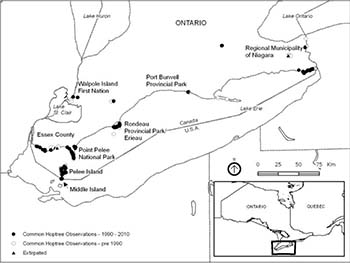
- Most populations currently occur in seven, well-separated, core areas: Middle Island, Pelee Island, Essex County (including Point Pelee National Park), Walpole Island First Nation, Rondeau Provincial Park/Erieau, Port Burwell Provincial Park, and the Regional Municipality of Niagara (Figure 2).
- The overall Canadian extent of occurrence is approximately 10 174 km2, while the area of occupancy is estimated at 7.5 km2 (Ambrose 2002).
Figure 1: North American distribution of all Common Hoptree subspecies (Ambrose and Aboud 1984)
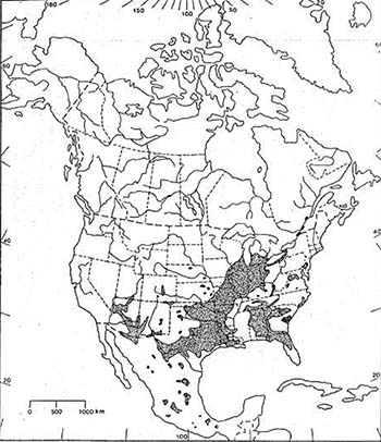
Figure 2: Canadian distribution of the Common Hoptree (Note: Not all points represent GPS-level accuracy)
- The species' distribution in Canada is believed to be naturally fragmented, with the two largest core areas occurring at the west (Essex County) and east (Regional Municipality of Niagara) ends of Lake Erie. This pattern of occupation, with only a few intervening populations, likely represents colonization from opposite ends of the lake following retreat of the glaciers 8 000 years ago (Ambrose et al. 1985).
- The species is found mainly in sandy shoreline habitats, which are harsh, dynamic and naturally limited in their availability.
- Thirty-five of 39 known populations are extant (see Table 1). This is a slight increase from the 34 extant locations reported in Ambrose (2002). Of those remaining, one has been transplanted (Long Point National Wildlife Area), one has been extirpated
footnote 4 (Linden Beach), and two are considered historicfootnote 5 (Niagara Glen/Niagara Gorge and four miles north of Queenston). Many others are believed to be of cultivated origin (see Appendix C). Two populations, believed to have been extirpated (Seacliff Park and Erie Beach), have been rediscovered and new populations continue to be located (Ambrose 2002, OMNR unpub. data).
Since the 2002 COSEWIC assessment, new information has become available. Key characteristics of the population sizes and trends of Common Hoptree in Canada are:
- The estimated 920 to 1 025 mature individuals in Canada (Ambrose 2002) is now believed to be an underestimate.
- A recent, targeted survey in Point Pelee National Park found nearly 16 900 stems of all age classes within a 1.75 km2 area of occupancy (Jalava 2008). Additional trees have since been found along the eastern shoreline (Parks Canada unpub. data). This represents the majority, possibly 96%, of Canadian trees based on previous population estimates.
- The Lighthouse Point population on Pelee Island is believed to be underestimated in size, perhaps by a factor of ten (Woodliffe pers. comm. 2009).
- Available population sizes (Ambrose 2002) for many other populations require updating.
- At least eighteen new locations have been discovered since 1984. While some do represent previously undiscovered populations, none are believed to signify species recovery since the 2002 COSEWIC report. Many expand the known area covered by existing populations.
- Population trends, based on available information, can be summarized as follows:
- In 2002, six populations were shown to have an overall decline of 12%, with reproductive individuals having dropped by 43% across 17 populations (where data were available for comparison), and 60% at Fish Point Provincial Nature Reserve alone over the previous 17 years. When all populations were considered, the decline in the number of mature individuals was suspected to be lower and less drastic than this 43% decline (Ambrose 2002), although this figure was used by COSEWIC to designate the species as Threatened.
- Current information suggests that the Point Pelee National Park mainland Common Hoptree population is likely relatively stable (Jalava 2008), while the Middle Island population increased slightly from 322 to 342 individuals of all age classes between 2000 and 2008 (Ambrose 2002, Jalava et al. 2008). However, substantial Double-crested Cormorant (Phalacrocorax auritis) impacts were noted on Middle Island that are likely to have long term, population level effects (Jalava et al. 2008).
Table 1: Extant Common Hoptree population locations
| Core area | Population | City/Township |
|---|---|---|
| Middle Island | Middle Island, Point Pelee National Park (critical habitat parcel #225_1) | Township of Pelee |
| Pelee Island | Fish Point Provincial Nature Reserve (#255_2) | Township of Pelee |
| Pelee Island | Red Cedar Savanna: NCC's Richard & Beryl Ivey/Stead-Martin property (#255_3) | Township of Pelee |
| Pelee Island | Stone Road Alvar (#255_4, #255_5, #255_6, and #255_7): including Mill Point and South Bay Shore | Township of Pelee |
| Pelee Island | West Shore Pump Station: includes the rocky limestone wooded area on west side of the island near abandoned quarry (#255_8) | Township of Pelee |
| Pelee Island | Middle Point: NCC's Novatney (#255_9 and #255_11) and Florian Diamante/Brown’s Road properties (#255_10) | Township of Pelee |
| Pelee Island | Lighthouse Point Provincial Nature Reserve (#255_12) | Township of Pelee |
| Essex County | Holiday Beach Conservation Area (also known as/Big Creek Marsh) | Amherstburg |
| Essex County | 1.5 km west of Comet | Amherstburg |
| Essex County | Lypps Beach | Essex |
| Essex County | Colchester Public Beach | Essex |
| Essex County | 1 km north of Colchester | Essex |
| Essex County | Fox Creek Conservation Area | Essex |
| Essex County | Cedar Beach Conservation Area (#255_13) | Kingsville |
| Essex County | Seacliff Beach (west of Leamington ferry dock) | Leamington |
| Essex County | Point Pelee National Park (#255_14) | Leamington |
| Essex County | Hillman Marsh Conservation Area sand spit/barrier beach (#255_15) | Leamington |
| Walpole Island First Nation | Chematogan: River Road | Walpole Island First Nation |
| Walpole Island First Nation | Old Ferry Road and Snye Roads | Walpole Island First Nation |
| Rondeau PP/Erieau (Municipality of Chatham-Kent) | Erieau/Rondeau: Laverne Kelly Memorial Park and adjacent lands, Erieau (#255_16), and Rondeau PP South Point barrier beach (#255_17 and #255_18) and Marsh Trail | Erieau and Morpeth |
| Rondeau PP Marsh Trail | Morpeth | |
| Rondeau PP Northwest (Lakeshore Road and dunes) (#255_19 and #255_20) | Morpeth | |
| 3.5 km east of Thamesville | Thamesville | |
| Port Burwell PP (Elgin County) | Port Burwell (formerly Iroquois Beach) PP (#255_21) | Bayham |
| Hardy Road | Brantford | |
| RM of Niagara | Nickel Beach (#225_22 and #255_23) and Lorraine (Cassaday) Point (#255_24) | Port Colborne |
| RM of Niagara | Lorraine Bay (#255_25) | Port Colborne |
| RM of Niagara | Cedar Bay Road beach access (#255_26) | Port Colborne |
| RM of Niagara | Sherkston Shores west (#255_27 and #255_28) | Port Colborne |
| RM of Niagara | Point Abino: Sherkston Shores east (Park) (#255_29), Pleasant Beach Road beach access (#255_30), Point Abino west shore (#255_31), Point Abino (#255_32), Point Abino peninsula sandland forest, Point Abino sand hills, and Marcy’s Woods | Port Colborne and Fort Erie |
| RM of Niagara | Terrace Lane, Crystal Beach (#255_33) | Fort Erie |
| RM of Niagara | Bertie Township/Fort Erie: Yacht Harbour Road (#255_34), Ridgeway, beach access points at Burleigh Road (#255_35), Bernard Ave. (#255_36), Colony Road (#255_37), and Windmill Point Road (#255_38), Stone Mill Road, Bertie Bay Road Allowance (#255_39), and beach accesses at Rose Hill Road (#255_40) and Buffalo Road/Crescent Beach (#255_41) | Fort Erie |
| RM of Niagara | Kraft Drain Mouth (#255_42) | Fort Erie |
| RM of Niagara | Erie Beach/Waverly Beach Park (#255_43) | Fort Erie |
| RM of Niagara | Navy Island | Niagara Falls |
3.3 Needs of the common hoptree
In Canada, the Common Hoptree is limited to extreme southwestern Ontario by climate, growing degree days, and its specialized habitat requirements. The small Canadian population has a restricted area of occupancy (only 7.5 km2), focussed almost entirely along the sandy, well-drained, often xeric
4. Threats
COSEWIC (2002) designated Common Hoptree as Threatened based on its restricted range, small population size, and the impacts of land development for cottages, nesting Double-crested Cormorants, and a twig-boring beetle. In the report leading to the designation, Ambrose (2002) also identified beach grooming, deer browse, invasive exotics, and storm erosion as threats to particular populations. Threats to the species were reassessed in December 2008 at a recovery strategy writing workshop. Habitat succession, recreational activities, livestock and vole browse, garbage dumping, and climate change were recognized as additional threats to the species (see individual sections below for discussion and justification). In addition, the term "Landscape Management" was used to encompass the impacts of both land development and beach grooming, while the impacts of storm erosion were included under the heading of "Altered Coastal Processes". More recently, Harris (pers. comm. 2011) has identified a second twig-boring insect (a moth) and a leaf-roller moth as potential threats. The impacts of the three insects have been combined under "Insect Herbivory". Table 2 provides additional detail surrounding each of these threats, including the overall level of concern (high, medium, or low), extent (range wide or local), occurrence (current or anticipated), frequency (continuous or unknown), severity (high, medium, or low), causal certainty (high, medium, or low), and ranked priority for action for each.
4.1 Threat assessment
Table 2: Threat assessment table
| Priority | Threat | Level of concern | Extent | Occurrence | Frequency | Severity | Causal certainty |
|---|---|---|---|---|---|---|---|
| 1 | Habitat loss or degradation: Landscape management | M-H | Range wide | Current | Continuous | M | H |
| 2 | Changes in ecological dynamics or natural processes: Hyperabundant, nesting double-crested cormorants | M | Localized | Current | Continuous | H | H |
| 3 | Changes in ecological dynamics or natural processes: Altered coastal processes | M | Range wide | Current | Continuous | M | M |
| 4 | Changes in ecological dynamics or natural processes: Habitat succession | M | Localized range wide? | Current | Continuous | M | H |
| 5 | Natural processes or activities: Insect herbivory | M | Localized | Current | ? | M | M |
| 6 | Exotic, invasive, or introduced species/genome: Invasive, exotic plants | M-L | Range wide | Current | Continuous | M | M |
| 7 | Disturbance or harm and biological resource use: Recreational activities (off-road vehicles, firewood collection, camping, trampling) | L | Localized | Current | Continuous | L | M |
| 8 | Natural processes or activities: Mammal herbivory (White-tailed Deer, livestock, vole) | L | Localized | ? | ? | ? | L |
| 9 | Habitat loss or degradation: Garbage dumping | L | Localized | Current | Continuous | ? | L |
| 10 | Climate and natural disasters: Climate change | L | Range wide | Anticipated | Continuous | ? | L |
4.2 Description of threats
4.2.1 Landscape management
The greatest threat to most Common Hoptree populations today (of medium severity range wide, with a high causal certainty and medium to high overall level of concern) is from plant (Common Hoptree or other) or whole habitat removal, and, in some cases, replacement. Shoreline development is intensive along much of Lake Erie’s north shore and habitat loss is occurring as land is developed for cottages. Many shoreline owners desire easier access to, and/or a view of, the water, or a manicured look to their beachfront property and therefore groom their private beaches or convert much of the area to lawn. Incompatible development has been observed at Fox Creek, Lypps, Linden, and Erie beaches and Thamesville, with extirpation of the Linden Beach population. Maintenance of roadsides and ditches (Thamesville, Walpole Island First Nation Snye Road at Old Ferry Road, Hillman Marsh Conservation Area, Lighthouse Point Provincial Nature Reserve, Point Pelee National Park, and around Pelee Island’s west shore pumping station), as well as the grooming of beaches (Cedar Beach; Holiday Beach; Colchester, Seacliff, Erieau, Erie, and Crescent Beach to Windmill Point) has also led to the damage or loss of individuals and/or habitat. Removal of Common Hoptrees also occurs due to the species' superficial resemblance to Poison Ivy (Rhus radicans). (Ambrose 2002). Historical landscape management impacts to Common Hoptree habitat include logging of Eastern Red Cedar (Juniperus virginiana) on Pelee Island and at Point Pelee National Park.
4.2.2 Hyperabundant, nesting double-crested cormorants
Hyperabundant, nesting Double-crested Cormorants impact the second largest Canadian Common Hoptree population, located on Middle Island. Since 2000, an average of 5 000 nests have been recorded on the island (Dobbie 2008). Research has shown that guano deposition can affect photosynthesis, resulting in damage and death to foliage and stems, as well as effecting soil chemistry changes (Hobara et al. 2001, Hebert et al. 2005). Areas under nesting trees are typically devoid of vegetation. A 2007 Common Hoptree inventory revealed that almost 20% of the population was severely damaged (50% or less of the plant in leaf) and another 19% was moderately damaged (51% to 90% of the plant living and in leaf). Thirteen percent had live stems clustered around a dead, central/main stem (Jalava et al. 2008). Although this is a localized threat, its high severity, established causal certainty, and potential, without management intervention, to extirpate this large population make it a threat of medium overall concern.
4.2.3 Altered coastal process
Altered coastal processes pose a medium level threat on Common Hoptree and its habitat. Extensive shoreline protection, stabilization, and alteration have led to disruption of the natural coastal processes that shape the dynamic shorelines and sand spits of Lake Erie’s north shore. The western shoreline of Point Pelee National Park has historically been an accreting or expanding shoreline. Between 2004 and 2006, this shoreline eroded 11 m. The Colchester to Southeast Shoal Beach Nourishment Study (Baird 2010a) determined that, without erosion mitigation measures and sand replenishment in the littoral cell, 126 ha could be lost from the western shore within the next 50 years. The eastern shoreline of the Point Pelee peninsula, from Port Alma to the tip of Point Pelee National Park, is a naturally eroding shoreline, but erosion rates have increased to an average of 4 m per year north of the national park due to shoreline development (Baird 2010b). Similar erosion issues exist along the south shore of Rondeau Provincial Park due to sand entrapment by the harbour breakwaters at Erieau. Decreased sand delivery and increased erosion means that less suitable habitat is available for germination and that established trees are closer to the shore and therefore more susceptible to the uprooting action of storm waves and ice. At a minimum, population level effects are expected at Point Pelee National Park. Habitat loss along the south shore of Rondeau Provincial Park may be offset by gains at Laverne Kelly Memorial Park where much of the sand destined for the provincial park is captured behind by the Erieau breakwater.
4.2.4 Habitat succession
The threat of habitat succession is also of a medium level of concern. Much of the alvar and savanna habitats of Pelee Island (Stone Road Alvar, Brown’s Road, Lighthouse Point and Fish Point Provincial Nature Reserves, and Red Cedar Savanna) and the Lake Erie Sand Spit Savannas of Point Pelee National Park are moderately to severely threatened by habitat succession (Nature Conservancy of Canada 2008, Dougan & Associates and McKay 2009). Habitat succession is considered the main threat to alvar habitats on Pelee Island. Habitat succession, woodland canopy shading, and vine cover is also affecting both of the Walpole Island First Nation Common Hoptree populations (Jacobs pers. comm. 2010). Population level effects are expected at these locations as canopy cover progresses beyond optimal conditions for Common Hoptree. The presence of this threat and its impact at other sites remains to be determined. The prevention of disturbance regimes such as fire, as well as the alteration of others like coastal processes, has allowed native species that would normally be excluded from these habitats to move in. Without intervention, these habitats may convert to thickets of Rough-leaved/Drummond’s Dogwood (Cornus drummondii), Common Prickly Ash (Aralia spinosa), Red Ash (Fraxinus pennsylvanica), Fragrant Sumac (Rhus aromatica), Staghorn Sumac (R. typhina), hawthorns (Crataegus spp.), and Dog Rose (Rosa canina), woodlands, or forests dominated by Eastern Red Cedar, oak (Quercus spp.), and maple (Acer spp.). Common Prickly Ash is successful as it is avoided by browsing species due to its prickles. Many pioneering tree and shrub species have allelopathic
4.2.5 Insect herbivory
A twig-boring bark beetle, identified by Steve Marshall (University of Guelph) as Phloeotribus scabricollis, is considered "a potential threat of unknown impact" (COSEWIC 2002). This species was found feeding on the flowering parts of Common Hoptrees at Fish Point and Lighthouse Point Provincial Nature Reserves, areas north of Point Pelee National Park, and at Hillman Marsh Conservation Area during surveys conducted for the 2002 COSEWIC report (Ambrose pers. comm. 2010). Large parts of the afflicted trees were affected, with decreased flowering and reduced tree crown resulting (Ambrose 2002). This beetle is likely native to Canada, given how specific beetles in this group are associated to their host plant. However, based on the fact that the species has only recently been located in the most southern areas of Canada, it may be adventive
A small moth, the Hop-tree Borer (Yponomeuta atomocella), is much rarer, with only four confirmed Canadian records. Further evidence of about 60 larvae at Point Pelee National Park and about 20 on Pelee Island was found in 2010. The larvae bore into the tips of young twigs, killing them. (Harris pers. comm. 2011). While recent occurrence levels suggest that this species may not affect Common Hoptree to any great extent, its impact in combination with other insect herbivores or if it periodically irrupts in larger numbers may be much greater, and therefore of concern.
The Hop-tree Leaf-roller Moth (Agonopterix pteleae), which is abundant at Point Pelee National Park, poses another possible threat (Harris pers. comm. 2011). Its larvae live in and feed on the rolled up edges of Common Hoptree leaves. Intensive and extensive defoliation (25% to 75% in 2005/6 [Scarr et al. 2007] and similar levels in 2009/10 [Harris pers. comm. 2011]) has been observed. At this time, however, it is unknown if the tens of thousands of insects observed in 2009/10 represent an irruption of a species that has long been present and that will eventually die back or if the moth is a recent arrival that may decrease Common Hoptree growth or survivorship (Harris pers. comm. 2011).
Based on the potential of these insects to cause significant population level effects, there is moderate concern regarding the threat that they pose to Common Hoptree. Further investigation is required to determine their basic life history, along with their full extent and frequency of occurrence, and the severity of the impacts of each range wide.
4.2.6 Invasive, exotic plants
Exotic and/or invasive plants and allelopathic tree species are a threat of medium to low level concern as they compete with Common Hoptree for water, nutrient, and light resources range-wide. Invasive, exotic plants are of concern at Fish Point Provincial Nature Reserve, Stone Road Alvar, Port Burwell Provincial Park (Ambrose 2002), and Erieau (McKay pers. obs. 2010). Of particular concern are Common Reed (Phragmites australis), White/Silver Poplar (Populus alba), Black Locust (Robinia pseudoacacia), Norway Maple (Acer platanoides), Scots Pine (Pinus sylvestris), Silver Birch (Betula pendula), White Mulberry (Morus alba), Black/European/Common Alder (Alnus glutinosa), Kentucky Bluegrass (Poa pratensis), Canada Bluegrass (Poa compressa), Quackgrass (Agropyron repens), Spotted Knapweed (Centaurea maculosa), Bouncing Bet (Saponaria officinalis), Japanese Barberry (Berberis thunbergii), and White Sweet Clover (Melilotus alba). Nitrogen-fixing species, like White Sweet Clover, improve soil conditions for other species that normally could not establish themselves in the nutrient depleted environments that Common Hoptree can, and therefore increase competition and shading by other species. On the alvars of Pelee Island, Eurasian pasture grasses are forming mats over bedrock, likely facilitating succession by shrubs (McFarlane pers. comm. 2010). Overall population level effects are considered moderate.
4.2.7 Other threats
Other low level, localized threats to Common Hoptree populations are believed to include the impacts of recreational activities that cause damage and/or breakage of all age classes (e.g. use of off-road vehicles [Stone Road Alvar], bicycling, firewood collection, camping, and trampling [Stone Road Alvar]), mammal herbivory (historically by White-tailed Deer at Point Pelee National Park and Rondeau Provincial Park prior to species management, by livestock browsing on foliage and flowering parts, and vole girdling), and garbage dumping (Stone Road Alvar, Lighthouse Point Provincial Nature Reserve, Erieau). The range-wide, potential threat of climate change may increase the frequency, severity, and timing of severe storm events and resultant wind and wave driven shoreline erosion, while reducing the amount of ice cover and associated scour. This can accelerate habitat succession and shoreline stabilization. Seedlings in already harsh environments may not be able to survive more severe temperature extremes of dryness and heat. In addition to these current threats, historical impacts to Common Hoptree habitat include soil compaction caused by cattle grazing on the Pelee Island alvars.
5. Population and distribution objectives
The current Threatened designation of the species based on a slight decline in area of occupancy (Ambrose 2002), less than 2 500 mature individuals in Canada, and less than 1 000 in any population (COSEWIC 2002) is likely no longer valid. Given the small distribution of the species in Canada and the large gaps that occur naturally among the core areas, it is neither realistic nor appropriate to expand its extent of occurrence and area of occupancy beyond 20 000 km2 (COSEWIC's Threatened category threshold) and 500 km2 (COSEWIC's Endangered category threshold) respectively, or to focus on reducing population fragmentation. It is also not warranted to manage the population so that the number of locations will not decline from the 34 currently documented in the COSEWIC report (Ambrose 2002), for two reasons. First, a decline in the number of populations may actually occur if a more comprehensive survey of the Lake Erie shoreline locates the species in new areas close to a previously known population(s) resulting in the merging of populations formerly considered to be separate. Second, Common Hoptree is short- lived, and 40% of its populations have less than five mature individuals, making them very susceptible to extirpation from natural disturbances caused by severe weather events. Given the natural rarity of the species' habitat, as well as the gaps that still occur in knowledge relating to population size across the species' range, population targets for recovery are difficult to establish at this time. As such, maintenance of the current, known state of the Common Hoptree population in Canada is the short-term focus with aspirations to improve both knowledge and sustainability of individual populations and core areas over the longer term. As such, the population and distribution objectives for the Common Hoptree are as follows:
- to maintain Common Hoptree populations in seven core areas: Middle Island, Pelee Island, Essex County (including Point Pelee National Park), Walpole Island First Nation, Rondeau Provincial Park/Erieau, Port Burwell Provincial Park, and the Regional Municipality of Niagara, within suitable habitat types (sandy shoreline and alvar),
- to ensure that the number of mature individuals does not decline below 1 000, and
- where feasible, to increase the size and reproductive capability of the smaller Common Hoptree populations that are currently considered unviable.
Key to the achievement of these population and distribution objectives over the long term is the restoration and maintenance of the natural disturbance mechanisms that provide for long term persistence of Common Hoptree critical habitat.
6. Broad strategies and general approaches to meet objectives
6.1 Actions already completed or currently underway
Efforts to update the population size and distribution data for the Common Hoptree in Canada have been initiated. Recent surveys have been completed in Point Pelee National Park (Jalava et al. 2008) and Rondeau Provincial Park (Dobbyn 2005) and are on-going in the Niagara region (OMNR unpubl. data). Population enhancement efforts have been ongoing at the Walpole Island First Nation since 2007 (Jacobs pers. comm. 2011) and an ecosystem protection plan is currently being developed based on the Community’s Traditional Ecological Knowledge (Macbeth pers. comm. 2011). Communication products include a Common Hoptree identification card (OMNR 2009a), poster (OMNR 2009b), sticker (OMNR 2009c), and magnet (OMNR 2009d) being used primarily with property owners in the Niagara area and messaging incorporated into programming and communications at Point Pelee National Park and Rondeau and Port Burwell Provincial Parks. Little research has been conducted across the species range. Table 3 outlines and prioritizes the broad strategies and approaches needed to address the threats (Section 4) and meet the population and distribution objectives (Section 5).
6.2 Strategic direction for recovery
In order to attain the Population and Distribution Objectives, the recovery planning approaches are summarized and ranked in Table 3 by their degree of urgency. Threats to the populations and information requirements are addressed. These approaches will be planned with due regard for negative impacts on other species at risk.
6.3 Narrative to support the recovery planning table
Population and habitat surveys and monitoring
Much of the survey data for Common Hoptree were gathered eight to ten years ago. More recent surveys at Point Pelee National Park inventoried the number of stems rather than the number of individuals, thus making population estimates and trends through time difficult to determine. A thorough investigation of extant, historic, and extirpated sites, as well as areas of suitable habitat (e.g. the Lake Erie shore between Essex County and Regional Municipality of Niagara and the shores and islands of the Niagara River) is needed to update information regarding each population.
Communicate best management practices, traditional ecological knowledge, and other important facts
There are many activities that can be undertaken by landowners and land managers independently or jointly to promote Common Hoptree recovery. Communication of appropriate activities and promotion and support of stewardship is key to Common Hoptree recovery. Naturally occurring coastal processes, fire, wind throw, insect infestation, disease, and other disturbances would have maintained the open gaps and edges for Common Hoptree colonization and persistence in the past. To the extent possible, such natural processes should be allowed to continue, or should be restored or mimicked. It should be noted that habitat restoration activities required to address the threats of exotic and/or invasive species and/or habitat succession will result in some reduction of canopy cover. These actions, in locations where these issues have been identified as a threat(s), are deemed necessary and are not considered destruction of critical habitat, provided that the alterations promote greater use of the habitat by Common Hoptree.
First Nation communities have maintained local ecosystems for generations through the use of community Traditional Ecological Knowledge. It is important to work with Knowledge Holders as a means for species and ecosystem protection and recovery. Traditional Ecological Knowledge and western science can, together, better inform assessment, monitoring, and recovery of the ecosystems that support specific species at risk.
Table 3: Recovery planning table
| Threat or limitation | Priority | Broad strategy to recovery | General description of research and management approaches |
|---|---|---|---|
| All | High | Conduct population and habitat surveys and monitoring |
|
| All | High | Communicate Best Management Practices (BMPs), and other important facts |
|
| Hyperabundant, nesting Double-crested Cormorants | High | Manage the impacts of nesting Double-crested Cormorants and communicate the need for such management |
|
| Altered coastal processes Landscape management Habitat succession | High | Mitigate erosion threats |
|
| All | Medium | Engage landowners to plan and implement protection and recovery measures. |
|
| All | Medium | Implement stewardship agreements |
|
| Landscape management Altered coastal processes Habitat succession Invasive, exotic plants Recreational activities | Medium | Manage vegetation |
|
| Hyperabundant, nesting Double-crested Cormorants | Medium | Research and assess cormorant impacts |
|
| Insect herbivores | Medium | Research and assess insect herbivore threats |
|
| Lack of basic information | Medium | Research basic biology and ecology |
|
| All | Medium | Adaptive management |
|
| Recreational activities | Low | Minimize recreational impacts |
|
| Animal browse/herbivory | Low | Manage hyperabundant White-tailed Deer and communicate the need for such management |
|
| All | Low | Research genetics |
|
| Landscape management Recreational activities | Low | Population repatriation and augmentation |
|
| Climate change | Low | Reduce climate change |
|
Research
There has been relatively little research on the Common Hoptree across its range, let alone more locally in Canada. As such, Table 3 identifies research needed to complete critical habitat identification and achieve the recovery strategy objectives for Common Hoptree. This includes research to gain basic biological and ecological facts about the species, as well as key information regarding genetics, finalizing threat assessments on the insect herbivores and cormorant impacts, and gathering the information necessary to allow for adaptive management.
Basic, local, life history information is lacking. Research into limiting resources/conditions (light, nutrients, erosion, and deposition patterns); interspecific interactions (pollinators, competitors, predators, and parasites); sex ratios; the means, distance, and frequency of seed dispersal; seed bank viability; seed setting rate; germination success in the wild; seedling survivorship; longevity; and Common Hoptree’s specific role in and impacts of succession is needed to inform species' recovery.
Genetic analysis is needed to guide site-based restoration to determine the native or introduced origin of trees at inland sites, the genetic differences within and between populations, the species' ability to clone (which could change the current understanding regarding the true number of individuals in Canada), site-specific diversity that may contribute to long-term retention or loss from certain sites, and the genetic significance of each site. This information will inform any restoration and augmentation activities deemed feasible.
7. Critical habitat
Critical habitat is defined in section 2(1) of SARA (2002) as "the habitat that is necessary for the survival or recovery of a listed wildlife species and that is identified as the species' critical habitat in the recovery strategy or in an action plan for the species". In order to achieve the population and distribution objectives, this recovery strategy identifies critical habitat for the Common Hoptree across its range in Canada, to the extent possible at this time.
7.1 Identification of the species' critical habitat
The locations and attributes of critical habitat were identified using the best available information, including observation data, indicating the presence of a single tree or a cluster of trees. In other circumstances, while specific point locations were not available, the species had been documented as occurring within a particular vegetation type(s) on a specific property. These data were collected by regional, provincial and federal agencies and their contractors, as well as by non- government organizations and individuals over the course of many years. Locations of known Common Hoptrees were obtained from Jalava et al. (2008), Dobbyn (2005), Natural Heritage Information Centre (NHIC unpub. data), Nature Conservancy of Canada (unpub. data), OMNR (unpub. data), and Ontario Nature (unpub. data). Additional map components were provided by the North American Atlas (Figures 4-35), OMNR's Land Information Ontario (Figures 4-14 and 16-35), Parks Canada Agency (Figure 5-8, 13-15, and 35), Nature Conservancy of Canada (Figures 5-7), Dougan and Associates (2007 – Figure 8), Essex Region Conservation Authority (2010 – Figures 6, 14, and 15), OMNR (Figure 12), Ontario Nature (Figure 6), and Ontario Parks (Figure 9).
Biophysical attributes of critical habitat
Across the species' range, the biophysical attributes of Common Hoptree critical habitat include open to moderately vegetated areas, often with a relatively high level of natural disturbance or harsh environmental conditions. These attributes occur in the following locations and situations:
- in open shoreline; graminoid
footnote 12 tallgrass prairie; graminoid, shrub, and treed sand dune and thicket Ecological Land Classification (ELC)footnote 13 vegetation types and ecosites (where vegetation types have not been identified); as well as the open forest edges that occur in sandy, well-drained, often xeric soils along the highly disturbed shorelines (beaches and sand dunes) of Lake Erie, - in other droughty substrates such as thin soil over limestone (i.e. the open, shrub, and treed alvar and thicket vegetation types and ecosites [where vegetation types have not been identified] of Pelee Island),
- at the forest and thicket edge interfacing with the bedrock/open beach/bar shoreline of Middle Island and Pelee Island,
- in the lake-bottom clays and clay-loams of Pelee Island drainage ditches (Ambrose 2002), and
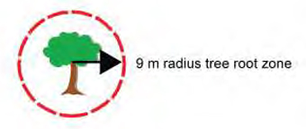
- a circle with a radius of 9 m
footnote 14 surrounding the trunk of each known, live, individual, naturally occurring Common Hoptree (see Figure 3) at identified locations (i.e. where data points currently exist), based on a critical root zone definition, used as a zone of protection for trees, of up to 36 times the diameter at breast height (dbhfootnote 15 ) of a tree (Johnson 1997).
Figure 3: Conceptual illustration of critical habitat (9 m radius tree root zone) around a single Common Hoptree
Geographic locations of critical habitat
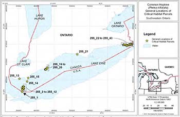
General locations of Common Hoptree critical habitat are shown in Figure 4. Site-specific critical habitat maps for 43 critical habitat parcels, covering 22 of 35 extant populations and six of seven core areas, are provided in Appendix B.
Figure 4: General locations of critical habitat for Common Hoptree in Canada
Critical habitat based on vegetation type
Ecological land classification vegetation type mapping
A number of approaches were used to identify critical habitat for the Common Hoptree across its Canadian range based on the type and availability of information. Where data were available to identify a Common Hoptree or trees within one or more ELC units (vegetation type or ecosite, where vegetation types were not available), critical habitat was identified as the boundaries of the occupied ELC unit(s), provided that they were considered suitable for survival and recovery of the species, as follows:
- Richard and Beryl Ivey (Stead - Martin) property, Pelee Island, Ontario (critical habitat parcel #255_3, Figure 5): the occupied Chinquapin Oak – Nodding Onion Treed Alvar Vegetation Type (Nature Conservancy of Canada unpub. data).
- Stone Road Alvar, Pelee Island, Ontario (parcel #255_4, #255_5, #255_6, and #255_7, Figure 6): the occupied Chinquapin Oak – Nodding Onion Treed Alvar, Red Cedar Alvar Woodland (Red Cedar Treed Alvar), and Dry Annual Open Alvar Pavement Vegetation Types, as well as the Shrub Alvar and Mineral Cultural Thicket Ecosites (Nature Conservancy of Canada unpub. data, Ontario Nature unpub. data).
- Florian Diamante (Brown’s Road) property, Pelee Island, Ontario (parcel #255_10, Figure 7): the occupied Mineral Cultural Thicket Ecosite (Nature Conservancy of Canada unpub. data).
- Point Pelee National Park, Leamington, Essex County, Ontario (parcel #255_14, Figure 8): the occupied Sea Rocket Sand Open Shoreline (SHOM1-2
footnote 16 ), Beach Grass – Wormwood Open Graminoid Sand Dune (SBOD1-3), Little Bluestem – Switchgrass– Beachgrass Open Graminoid Sand Dune (SBOD1-1), Hoptree Shrub Sand Dune (SBSD1-2), Red Cedar Treed Sand Dune (SBTD1-3), Dry – Fresh Drummond’s Dogwood Deciduous Shrub Thicket, and Fresh – Moist Cottonwood Deciduous Forest (FODM8-3) Vegetation Types adjacent to the shores of Lake Erie (Lee 2004, Dougan & Associates 2007, Jalava et al. 2008). - Rondeau Provincial Park, Morpeth, Municipality of Chatham-Kent, Ontario (parcel #255_17, #255_18, #255_19, and #255_20, Figure 9): the occupied Little Bluestem – Switchgrass – Beachgrass Open Graminoid Sand Dune, Dry Big Bluestem Graminoid Tallgrass Prairie (MEGM1-2), Cottonwood Treed Sand Dune (SBTD1-1), and Willow Shrub Sand Dune (SBSD1-3) Vegetation Types (Dobbyn and Pasma 2009).
- Fish Point Provincial Nature Reserve, Pelee Island (parcel 255_2, Figure 10): all occupied ELC vegetation types and ecosites (where no vegetation types are defined).
- Lighthouse Point Provincial Nature Reserve, Pelee Island (parcel 255_12, Figure 11): all occupied ELC vegetation types and ecosites (where no vegetation types are defined).
Critical habitat has been mapped in all but the latter two locations where the area within which critical habitat is found has been mapped. This is due to the fact that the location of all Common Hoptrees at these two sites is not currently known.
Other types of habitat mapping
When ELC data were not available, other types of vegetation mapping were used to identify Common Hoptree critical habitat, as follows:
Erieau, Municipality of Chatham-Kent, Ontario (parcel #255_16, Figure 12): all areas of naturally-occurring vegetation within and in the vicinity of Laverne Kelly Memorial Park.
Critical habitat based on observations of trees
Bounding area
Where no vegetation community mapping was available, an occupancy approach, based on the observation of trees, was applied. Critical habitat was based on UTM (Universal Transverse Mercator coordinate system) locations of individual trees or clusters of trees, obtained using a GPS (geographic positioning system) unit. Coordinates obtained using this technology are expected to be accurate to at least 10 m.
In these situations, the area within which critical habitat (based on biophysical attributes) is found is identified as a rectangle that stretches 150 m perpendicular to the water’s edge to encompass the tree(s) and extends along and parallel to the shoreline 150 m on either side of the Common Hoptree(s). The 150 m value was chosen as surveyors in the Niagara Region indicated that most populations seemed to be a maximum of 150 m long (Brant pers. comm. 2009).
As some data points represent multiple trees and it is unclear where within the tree cluster the coordinates were taken, the 150 m distance has been applied in either direction parallel to the shoreline to ensure critical habitat protection along a 300 m stretch of shoreline. This approach was applied in the following locations:
Pelee Island
- West Shore Pumping Station, Pelee Island, Ontario (parcel #255_8, Figure 13): (NHIC unpub. data),
- Novatney Property, Pelee Island, Ontario (parcel #255_9 and 255_11, Figure 7) (Nature Conservancy of Canada unpub. data),
Essex County (NHIC unpub. data):
- Cedar Beach Conservation Area, Kingsville, Ontario (parcel #255_13, Figure 14),
- Hillman Marsh Conservation Area, Leamington, Ontario (parcel #255_15, Figure 15),
Elgin County (Dobbyn pers. comm. 2011)
- Port Burwell Provincial Park, Port Burwell, Ontario (parcel 255_21, Figure 16): the width of the Park shoreline is included as the exact location of all trees is unknown,
Regional Municipality of Niagara (OMNR unpub. data):
- Nickel Beach, Port Colborne, Ontario (parcel #255_22 and 255_23, Figure 17),
- Lorraine Point, Humberstone, Port Colborne, Ontario (parcel #255_24, Figure 18),
- Lorraine Bay, Humberstone, Port Colborne, Ontario (parcel #255_25, Figure 19),
- Cedar Bay Road beach access, Port Colborne, Ontario (parcel #255_26, Figure 20),
- Sherkston Shores, Port Colborne, Ontario (parcel #255-28 and #255_29, Figures 21 and 22),
- Point Abino, west shore, Fort Erie, Ontario (parcel #255_31, Figure 23),
- Point Abino, Fort Erie, Ontario (parcel #255_32, Figure 24),
- Terrace Lane, Crystal Beach, Fort Erie, Ontario (parcel #255_33, Figure 25),
- Yacht Harbour Road, Fort Erie, Ontario (parcel #255_34, Figure 26),
- Burleigh Road beach access, Fort Erie, Ontario (parcel #255_35, Figure 26),
- Bernard Ave beach access, Fort Erie, Ontario (parcel #255_36, Figure 27),
- Colony Road beach access, Fort Erie, Ontario (parcel #255_37, Figure 28),
- Windmill Point Road beach access, Fort Erie, Ontario (parcel #255_38, Figure 29),
- Bertie Bay Road Allowance, Fort Erie, Ontario (parcel #255_39, Figure 30),
- Rose Hill Road beach access, Fort Erie, Ontario (parcel #255_40, Figure 31),
- Kraft Drain Mouth, Fort Erie, Ontario (parcel #255_42, Figure 32), and
- Waverly Beach Park, Fort Erie, Ontario (parcel #255_43, Figure 33).
Where trees were found more than 150 m away from the shoreline, the area within which critical habitat is found is identified as a circle with a radius of 150 m from the trunk of each live, individual, naturally occurring Common Hoptree or a data point representing multiple individuals. This approach was applied in the following locations:
Regional Municipality of Niagara (OMNR unpub. data):
- Sherkston Shores, Port Colborne, Ontario (parcel #255_27, Figure 21),
- Pleasant Beach Road beach access, Port Colborne, Ontario (parcel #255_30, Figure 22), and
- Buffalo Road beach access, Fort Erie, Ontario (parcel #255_41, Figure 34).
Critical habitat based on historic and expected restored conditions
Documentation, prior to severe degradation of all Middle Island vegetation layers (ground cover to canopy) by hyperabundant, nesting Double-crested Cormorants, indicates that Common Hoptrees were found along the shoreline, as would be expected of a species that does not flower or germinate in partial to full shade (Rennie 1982, Kamstra et al. 1995, Ambrose 2002). Efforts are underway to protect and restore the ecological integrity of the Carolinian ecosystem on Middle Island. Specific aims include significantly reducing the loss of dense (healthy) forest canopy cover on the island due to the impacts of Double-crested Cormorant nesting and protecting SARA-listed species at risk (Dobbie 2008). Given that this goal, linked to historic conditions on the island, is expected, as a result of light availability, to once again limit reproductive and germinating Common Hoptrees to the vegetation/shoreline interface, critical habitat is identified as follows:
- Middle Island, Point Pelee National Park, western Lake Erie basin, Ontario (parcel #225_1, Figure 35): an 18 m zone (the diameter of a single tree root zone) around the entire island, extending inland from the vegetation/shoreline interface, exclusive of marsh and shallow water vegetation communities.
Existing trees growing outside of this area may persist, but are not expected to contribute reproductively to the population once a dense, healthy forest canopy cover is restored. They are therefore not expected to contribute to the long-term recovery of the species, although they are still protected under the SARA [S. 32].
Critical habitat exclusions
Common Hoptree is a shade intolerant species, known to be limited in its ability to flower and germinate under forest canopy (Ambrose 2002). As such, occupied forest vegetation types, with the exception of those forming a narrow edge between more open habitats and more broad expanses of forest, were excluded from critical habitat as these areas cannot be expected to contribute to short- or long-term population and distribution objectives but rather may result in local extirpations. Unvegetated beach/bar and bedrock areas are excluded from critical habitat as Common Hoptree tends to establish in areas where substrate stabilization has been initiated by grasses. Open water is also excluded from critical habitat.
Critical habitat has not been identified for Common Hoptree populations (e.g. Walpole Island First Nation populations) at this time where GPS coordinates accurate to 10 m are not currently available. Critical habitat has not been identified for trees that are known to have been planted or transplanted. Records that are older than 20 years (pre 1990), with no verification through follow-up surveys, were deemed historical and were also not considered during critical habitat identification. Existing anthropogenic features are excluded from critical habitat as they are not suitable habitats for the long-term persistence of this species. These features include, but are not limited to, existing infrastructure (e.g., roads, trails, parking lots, utility corridors, and buildings), existing cultivated areas (e.g. agricultural fields), or unnatural vegetation types (e.g., baseball fields, grassed areas, and septic beds). Areas where Common Hoptrees are found in or adjacent to anthropogenic features (e.g. in utility corridors like hydro, or adjacent to roads and trails etc.) are also excluded from critical habitat in locations where their presence is opportunistically related to the existence of these features (i.e. in locations other than suitable, naturally-occurring vegetation types where the species would be expected to be found without the presence of the anthropogenic feature). Should these anthropogenic features disappear in areas of unsuitable habitat (e.g. through trail, road, or hydro corridor removal or abandonment), the Common Hoptrees present might remain for some time, but would not be expected to continue to reproduce, nor would seedlings be anticipated to germinate under the full canopy cover that would eventually result from natural succession. As on-going maintenance of these areas as suitable habitat for Common Hoptree cannot be guaranteed, and without utility corridor maintenance these areas would quickly become unsuitable for Common Hoptree, these areas cannot be expected to contribute to short- or long-term population and distribution objectives. They are therefore excluded from critical habitat. In addition, it is not believed that these sites are required in order to achieve the population and distribution objectives.
7.2 Schedule of studies to identify critical habitat
While critical habitat has been identified for 22 of the 35 extant Common Hoptree populations in six of the seven core areas, further work is required to complete critical habitat identification. This work is outlined in Table 4. Further questions may arise as this work proceeds.
Table 4: Schedule of studies
| Description of activity | Rationale | Timeline |
|---|---|---|
|
Survey extant populations to determine:
|
This information is needed to ensure protection of sufficient critical habitat to support the population and distribution objectives and to prioritize critical habitat selection should all areas of habitat not be required to support these objectives. | 2011 - 2015 |
| Assess data collected to determine the features, quantity, and spatial arrangement of critical habitat required, including important limiting resources and conditions. | Determine what critical habitat is, how much is required and where it needs to be located within the core areas in order to achieve the population and distribution objectives. | 2011 - 2015 |
| Complete critical habitat modeling and/or identification and delineation by refining critical habitat identification using the most appropriate method(s) (ELC, supervised classification of satellite imagery, aerial photography, tree root zone, and/or other). | Complete identification and delineation of critical habitat. | 2011 - 2016 |
7.3 Activities likely to result in the destruction of critical habitat
Understanding what constitutes destruction of critical habitat is necessary for the protection and management of critical habitat. Destruction is determined on a case by case basis. Destruction would result if part of the critical habitat were degraded, either permanently or temporarily, such that it would not serve its function when needed by the species. Destruction may result from single or multiple activities at one point in time or from the cumulative effects of one or more activities over time.
Common Hoptree critical habitat may be destroyed by activities that have the following effects:
- alteration of the natural processes and/or disturbance regimes within or outside of critical habitat, including coastal and aeolian Aeolian refers to something of or related to, produced or carried by the wind; in this case, wind-generated. processes that affect sand deposition/accretion and erosion rates and/or the seral A seral stage is an intermediate phase during ecological succession of an ecosystem as it advances toward its climax community. stage of vegetation communities within critical habitat;
- excessive alteration of the canopy cover (resulting in increased shading or sun scald with excessive canopy removal), or the understory vegetation (resulting in the loss of germination sites) within critical habitat, and
- soil compaction within critical habitat (e.g. can reduce or eliminate germination and/or reduce the availability of water and/or nutrients to trees).
Examples of activities in or near critical habitat that may result in the destruction of critical habitat include, but are not limited to:
- development/construction of new infrastructure within critical habitat (homes; sheds; industrial or other buildings; roads, trails and paths [logging purposes included]; parking lots, clearings, and areas for stockpiling timber; pipelines and water mains; sewage systems; wind power structures; etc.) or adjacent to critical habitat (docks, piers, groynes, or shoreline hardening structures etc. that will affect the delivery of sediment to critical habitat);
- upgrades and/or maintenance to existing infrastructure within critical habitat (e.g. building additions, cutting, trimming, and/or removal of vegetation that has not met environmental assessment requirements) or adjacent to critical habitat (modifications to docks, piers, groynes, or shoreline hardening structures etc. that will affect the delivery of sediment to critical habitat);
- aggregate extraction (e.g. sand and/or gravel mining/quarrying within critical habitat, or offshore sand mining near critical habitat that alters sand deposition rates in critical habitat),
- agricultural activities within critical habitat (land clearing, tilling soil, livestock grazing);
- unregulated use of off-road vehicles or other acts vandalism within critical habitat;
- removal of large quantities of associated native species or whole habitats within critical habitat (e.g. through beach grooming, cutting, mowing, and/or raking that results in sun scald to Common Hoptrees or the loss of suitable seedling germination sites); and
- deliberate planting of non-indigenous (exotic), and/or invasive species into critical habitat.
8. Measuring progress
The performance indicators presented below provide a way to define and measure progress toward achieving the population and distribution objectives. Specific progress towards implementing the recovery strategy will be measured against indicators outlined in subsequent action plans. Within five years of final posting, implementation of this recovery strategy will be measured against the following:
- Common Hoptree populations have been maintained in six core areas (Pelee Island, Essex County, Walpole Island First Nation, Rondeau Provincial Park/Erieau, Port Burwell Provincial Park, and the Regional Municipality of Niagara),
- the Middle Island Common Hoptree population has not been extirpated,
- the number of mature individuals is 1 000 or more, and
- Common Hoptree habitat suitability, as identified in the biophysical characteristics of critical habitat in Section 7.1, has been maintained in areas identified as critical habitat.
9. Statement on action plans
One or more action plans related to this recovery strategy will be completed by June 2016, providing details regarding specific recovery measures to be undertaken.
10. References
Ambrose, J.D. 2002. Update COSEWIC Status Report on the Common Hoptree (Ptelea trifoliata) in Canada, in COSEWIC Assessment and Update Status Report on the Common Hoptree (Ptelea trifoliata) in Canada. Committee on the Status of Endangered Wildlife in Canada. Ottawa, Ontario. 14 pp.
Ambrose, J.D., pers. comm. 2010. Telephone conversation with V. McKay. Private Consultant, Guelph, Ontario.
Ambrose, J. and S. Aboud. 1984. Status report on the Hop Tree (Ptelea trifoliata). Committee on the Status of Endangered Wildlife in Canada. Ottawa, Ontario. 26 pp.
Ambrose, J.D., P.G. Kevan, and R.M. Gadawski. 1985. Hop tree (Ptelea trifoliata) in Canada: population and reproductive biology of a rare species. Canadian Journal of Botany 63: 1928-1935.
Baird, W.F. & Associates Coastal Engineers Ltd. 2010a. Colchester to Southeast Shoal Beach Nourishment Study. Prepared for Essex Region Conservation Authority, Essex, Ontario. Project No. 11395.101. 78 pp. + Appendices A–D.
Baird, W.F. & Associates Coastal Engineers Ltd. 2010b. Point Pelee Peninsula Eastern Shoreline Erosion Mitigation Study. Prepared for Essex Region Conservation Authority, Essex, Ontario. Project No. 11329.101. 65 pp. + Appendices A–F.
Brant, A., pers. comm. 2009. Telephone conversation with V. McKay. December 2009. Species at Risk Technician, OMNR, Guelph District, Vineland Area, Vineland, Ontario.
COSEWIC. 2002. COSEWIC Assessment and Update Status Report on the Common Hoptree (Ptelea trifoliata) in Canada. Committee on the Status of Endangered Wildlife in Canada, Ottawa, Ontario. vi + 14 pp.
Dobbie, T. 2008. Point Pelee National Park of Canada Middle Island Conservation Plan. Parks Canada Agency, Leamington, Ontario. 44 pp.
Dobbyn, S. 2005. An Inventory of the Common Hoptree (Ptelea trifoliata) in Rondeau Provincial Park. Ontario Parks, Morpeth, Ontario. 7 pp.
Dobbyn, S. and L. Pasma. 2009. Life Science Inventory and Evaluation of Rondeau Provincial Park. Draft. Ontario Parks, Morpeth, Ontario.
Dougan & Associates. 2006. Species Descriptions for Species Occurring in Lake Erie Sand Spit Savannas in Canada. Prepared for Point Pelee National Park, Parks Canada Agency, Leamington, Ontario. 132 pp.
Dougan & Associates. 2007. Point Pelee National Park Ecological Land Classification and Plant Species at Risk Mapping and Status. Prepared for Point Pelee National Park, Parks Canada Agency, Leamington, Ontario. 109 pp. + Appendices A–I.
Dougan & Associates and V.L. McKay. 2009. An Ecosystem-based Recovery Strategy for the Eastern Prickly Pear Cactus (Opuntia humifusa) – Lake Erie Sand Spit Savannas in Canada (Draft). Species at Risk Act Recovery Strategy Series. Parks Canada Agency, Ottawa, Ontario. xiv + 147 pp.
Farrar, J.L. 1995. Trees in Canada. Fitzhenry and Whiteside Limited, Markham, Ontario. 502 pp.
Government of Canada. 2009. Species at Risk Act Policies: Overarching Policy Framework. Draft. Environment Canada, Ottawa, Ontario. Electronic monograph in PDF format. 38 pp.
Harris, A., pers. comm. 2011. E-mail correspondence to V. McKay. February 2011. Northern Bioscience, Thunder Bay, Ontario.
Hebert, C.E., J.A. Duffe, D.V. Weseloh, E.M.T. Senese, and G.D. Haffner. 2005. Unique island habitats may be threatened by double-crested cormorants. Journal of Wildlife Management 69(1): 68-76.
Hobara, S., T. Osono, K. Koba, N. Tokuchi, S. Fujiwara, and K. Kameda. 2001. Forest floor quality and N transformations in a temperate forest affected by avian-derived N deposition. Water, Air, and Soil Pollution. 130: 679-684.
Hutchinson, B.C., W.B. Ranta, and T. Mosquin. 1988. White-tailed Deer Management Plan for Point Pelee National Park. Environment Canada, Parks Service, Natural Resource Conservation, Leamington, Ontario. 72 pp. + appendices.
Jacobs, C., pers. comm. 2010. E-mail correspondence to V. McKay. April 2010. Natural Heritage Co-ordinator, Walpole Island First Nation Heritage Centre, Walpole Island First Nation, Ontario.
Jacobs, C., pers. comm. 2011. E-mail correspondence to K. Borg. April 2011. Natural Heritage Co-ordinator, Walpole Island First Nation Heritage Centre, Walpole Island First Nation, Ontario.
Jalava, J.V. 2008. COSEWIC-designated Plant Species at Risk Inventories, Point Pelee National Park, including Sturgeon Creek Administrative Centre and Middle Island, 2007. Volume 2: Managed Area Element Status Assessments. Prepared for Point Pelee National Park, Parks Canada Agency, Leamington, Ontario. ii + 103 pp.
Jalava, J.V., P.L. Wilson, and R.A. Jones. 2008. COSEWIC-designated Plant Species at Risk Inventories, Point Pelee National Park, including Sturgeon Creek Administrative Centre and Middle Island, 2007. Volume 1: Summary Report. Prepared for Point Pelee National Park, Parks Canada Agency, Leamington, Ontario. vii + 126 pp.
Johnson, G.R. 1997. Tree preservation during construction: a guide to estimating costs. Minnesota Extension Service, University of Minnesota, Minnesota.
Kamstra, J., M.J. Oldham, and P.A. Woodliffe. 1995. A Life Science Inventory and Evaluation of Six Natural Areas in the Erie Islands, Essex County, Ontario: Fish Point Provincial Nature Reserve, Lighthouse Point Provincial Nature Reserve, Stone Road Complex, Middle Point, East Sister Island Provincial Nature Reserve, and Middle Island. Aylmer District (Chatham Area), OMNR, Chatham, Ontario. 140 pp. + 8 Appendices + folded maps.
Lebedyk, D. 2010. E-mail correspondence to V. McKay. December 2010. Conservation Biologist, Essex Region Conservation Authority, Essex, Ontario.
Lee, H.T. 2004. Provincial ELC Catalogue Version 8. OMNR, Southcentral Science Section, Science Development and Transfer Branch, London, Ontario. Microsoft Excel File.
Lee, H.T., W.D. Bakowsky, J. Riley, J. Bowles, M. Puddister, P. Uhlig, and S. McMurray. 1998. Ecological Land Classification for Southern Ontario: First Approximation and its Application. OMNR, Southcentral Science Section, Science Development and Transfer Branch, London, Ontario. SCSS Field Guide FG-02. 225 pp.
Little, E.L., Jr. 1976. Atlas of United States trees, volume 3, minor Western hardwoods: U.S. Department of Agriculture Miscellaneous Publication 1314. 13 pp. + 290 maps.
Macbeth, J., pers. comm. 2011. E-mail correspondence to K. Borg. April 2011. Project Review Coordinator, Walpole Island First Nation Heritage Centre, Walpole Island First Nation, Ontario.
McFarlane, M., pers. comm. 2010. E-mail correspondence to V. McKay. March 2010. Conservation Biologist, Southwestern Ontario, Nature Conservancy of Canada, London, Ontario.
McLeod, K.W. and P.G. Murphy. 1983. Factors affecting growth of Ptelea trifoliata seedlings. Canadian Journal of Botany. 61: 2410-2415.
Nature Conservancy of Canada. 2008. Management Guidelines: Pelee Island Alvars. Nature Conservancy of Canada, Southwestern Ontario Region, London, Ontario. 43 pp. Web site: http://www.carolinian.org/Documents/student_assistantship_program/Reports/Pelee%20Alvar%20Mgmt%20Guide%20CURRENT.pdf [link inactive].
NatureServe. 2011. NatureServe Explorer: An Online Encyclopedia of Life. Web site: http://www.natureserve.org/explorer/ [Accessed: February 8, 2011].
Oldham, M.J., pers. comm. 2010. E-mail correspondence to V. McKay. December 2010. Botanist/Herpetologist, NHIC, Peterborough, Ontario.
OMNR. 1991. Rondeau Provincial Park Management Plan. Queens Printer for Ontario, Toronto, Ontario. ii +27 pp. + amendments.
OMNR. Guelph_Common_Hoptree.xls and COHO 2009 Niagara ab.xls. Excel Files. Unpublished Data covering years 2005 - 2009.
OMNR. 2009a. Common Hoptree Species at Risk. Identification card. OMNR, Vineland, Ontario.
OMNR. 2009b. Common Hoptree Species at Risk. Poster. OMNR, Vineland, Ontario.
OMNR. 2009c. Threatened Species. Common Hoptree Ptelea trifoliata. Help Protect Sand Dunes. Sticker. OMNR, Vineland, Ontario.
OMNR. 2009d. Threatened Species. Common Hoptree Ptelea trifoliata. Help Protect Sand Dunes. Magnet. OMNR, Vineland, Ontario.
OMNR. 2010. Species at Risk in Ontario List. OMNR, Peterborough, Ontario. Web site: /page/species-risk. [Accessed: February 8, 2011].
Rennie, F. 1982. An Assessment of the National Significance of Middle Island, Ontario. Parks System Planning, National Parks Branch, Parks Canada Agency, Ottawa, Ontario. 96 pp.
Ritchie, R., pers. comm. 2010. E-mail correspondence to V. McKay. December 2010. Retired Park Naturalist, Niagara Parks Commission, Niagara Falls, Ontario.
Rousseau, C. 1974. Géographie floristique du Québec-Labrador. Travaux et documents du centre d'Études Nordiques. Les Presses de l'Université Laval, Laval, Québec. 799 pp.
Scarr, T., A. Hopkin, and J. Pollard (eds). 2007. Forest Health Conditions in Ontario, 2006. Queen’s Printer for Ontario, Toronto, Ontario. 81 pp.
Stone, E.L. and P.J. Kalisz. 1990. On the maximum extent of tree roots. Forest Ecology and Management 46: 59-102.
Sutherland, D.A., pers. comm. 2010. E-mail correspondence to V. McKay. December 2010. Zoologist, NHIC, Peterborough, Ontario.
Waldron, G. 2003. Trees of the Carolinian Forest. The Boston Mills Press, Erin, Ontario. 275 pp.
Woodliffe, P.A., pers. comm. 2009. Telephone conversation with V. McKay. December 2009. District Ecologist, Aylmer District, OMNR, Chatham, Ontario.
Woodliffe, P.A., pers. comm. 2010. E-mail correspondence to V. McKay. November 2010. District Ecologist, Aylmer District, OMNR, Chatham, Ontario.
Appendix A: Effects on the environment and other species
A strategic environmental assessment (SEA) is conducted on all SARA recovery planning documents, in accordance with the Cabinet Directive on the Environmental Assessment of Policy, Plan, and Program Proposals. The purpose of a SEA is to incorporate environmental considerations into the development of public policies, plans, and program proposals to support environmentally sound decision-making.
Recovery planning is intended to benefit species at risk and biodiversity in general. However, it is recognized that strategies may also inadvertently lead to environmental effects beyond the intended benefits. The planning process, based on national guidelines, directly incorporates consideration of all environmental effects, with a particular focus on possible impacts upon non-target species or habitats. The results of the SEA are incorporated directly into the strategy itself, but are also summarized below in this statement.
Most broad strategies and approaches to recover Common Hoptree are expected to have either no significant adverse impacts or to have a positive effect on the environments in which it is found, as well as on the other species occupying those areas.
Common Hoptrees are almost entirely restricted in their range to Lake Erie coastal habitats that are, in at least some locations, home to other nationally and/or provincially designated species at risk (e.g. Eastern Prickly Pear Cactus [Opuntia humifusa], Dwarf Hackberry [C. tenuifolia], Fowler’s Toad [Anaxyrus fowleri], Five-lined Skink [Plestiodon fasciatus], Eastern Foxsnake [Pantherophis gloydi], and Eastern Hog-nosed Snake [Heterodon platyrhinos], to name a few). The Common Hoptree plays an important role in shoreline stabilization, so its recovery is expected to help prevent physical loss of shoreline areas and habitats needed by many other species. As such, Common Hoptree recovery is expected to benefit species associates. Protection of Common Hoptree and its habitat will help to maintain robust and intact coastal dune ecosystems, and limestone alvars and their plant communities, habitats which are, in themselves, provincially, and in some cases even globally, rare (Dougan & Associates and McKay 2009). This tree is also the preferred host plant, and one of only two species, on which the provincially rare Giant Swallowtail (Papilio cresphontes) butterfly larvae feed (Ambrose 2002). A twig-boring beetle and two moths have also been found to feed on Common Hoptree (see Section 4.2.5).
Common Hoptree surveys and research may result in the location of other species at risk and/or identify the threats acting on them and the associated level of concern. Critical habitat protection and the implementation of best management practices, restoration of coastal processes, removal of invasive, exotic species from suitable habitat, and other work to reduce the impacts of unchecked habitat succession would similarly be expected to benefit the suite of open habitat species typically found in association with Common Hoptree, particularly in dynamic shoreline areas. Increased public awareness of the species, including information on where it occurs, threats to it and actions that individuals can take to aid its recovery are likely to result in benefits to the suite of species found in sensitive shoreline areas through reduced recreational and residential impacts. Similarly, management of hyperabundant species will benefit many species that are impacted by deer browse or by the guano and altered habitat conditions brought about by mass nesting of Double-crested Cormorants on Middle Island. Implementation of erosion mitigation measures on both sides of the Point Pelee peninsula, over the long-term, should slow the physical loss of habitat that Common Hoptree and many other species depend upon.
Negative environmental effects arising from this strategy will likely be confined to species having detrimental effects on Common Hoptree (e.g. hyperabundant White-tailed Deer and Double-crested Cormorants) or its habitat (i.e. through vegetation succession to closed canopy habitats).
Different plant species have varying levels of shade tolerance. Favourable open canopy conditions for the Common Hoptree may not be optimal for co-occurring species. Common Hoptree management may include the control of other plants to maintain an optimal early to mid successional stage. Effects could include potential loss of individuals of other species, including other species at risk, or a decrease in their fitness; potential loss of mature forest, woodland, and/or thicket habitats; loss of downed, woody debris that can provide important microhabitat for other species; displacement of existing vegetation; and the potential disturbance of soil contaminants that may affect other species. The potential loss of individual plants from trampling and disturbance due to research and/or monitoring activities could also occur. An ecosystem- based approach to implementation of the broad strategies to achieve Common Hoptree recovery, which considers the needs of the multitude of significant and common species and habitats found in proximity to Common Hoptree, is therefore recommended as crucial to their persistence, maintenance, and recovery. Implementation of habitat management approaches in particular needs to be done in such a way as to ensure that a mosaic of open and closed habitats are maintained to ensure viability of all species in that environment. Restricting vegetation management activities to portions of the habitat and managing the timing of activities should reduce disturbance to all species by providing "refuge" areas.
Where necessary, potential negative impacts of habitat modification, invasive species removals, shoreline alterations, and/or species management projects at Point Pelee National Park or as part of other federally funded projects will be addressed and corresponding mitigation measures will be developed in a project level environmental assessment under the Canadian Environmental Assessment Act. The same is done at provincial park sites under A Class Environmental Assessment for Provincial Parks and Conservation Reserves. Environmental assessments may require follow-up to determine the success of the techniques implemented, and the accuracy of the effects predicted. This will allow for adaptive management, the mitigation of potential environmental effects, and continual adjustment and improvement of recovery efforts. Hyperabundant species management of Double-crested Cormorants (Middle Island, Point Pelee National Park) and White-tailed Deer (mainland Point Pelee National Park and Rondeau Provincial Park) have been reviewed via environmental assessments and other processes and been deemed to be in the best interests of maintaining overall ecological integrity in the areas that they currently occur. Mitigation measures to address potential negative environmental effects are included in these reports and are applied during management activities. New iterations of these plans will continue to be reviewed using these environmental assessment processes. Consultation with archaeologists and increased visitor and public awareness of damaging activities are expected to alleviate the potential to damage archaeological resources, and negative impacts on the experiences of visitors to public areas respectively.
Appendix B: Critical habitat maps
Figure 5: Location and extent of critical habitat parcel #255_3 for Common Hoptree
Critical habitat does not include existing infrastructure, existing cultivated areas, unnatural vegetation types, unvegetated beach, or areas in or adjacent to anthropogenic features where the presence of Common Hoptree is opportunistically related to the existence of these features, as described in Section 7.1.
Note: The term "Protected Areas" used in the critical habitat maps has no relation to protection requirements under SARA.
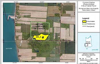
Figure 6: Location and extent of critical habitat parcel #255_4, #255_5, #255_6, and #255_7 for Common Hoptree
Critical habitat does not include existing infrastructure, existing cultivated areas, unnatural vegetation types, unvegetated beach/bar and bedrock, or areas in or adjacent to anthropogenic features where the presence of Common Hoptree is opportunistically related to the existence of these features, as described in Section 7.1.
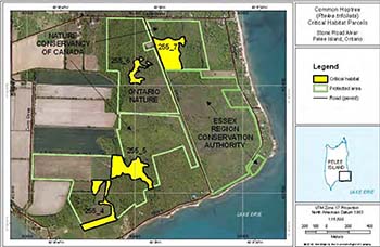
Figure 7: Area within which critical habitat for Common Hoptree is found (critical habitat parcel #255_9 and #255_11 – please refer to Section 7.1 for the description of biophysical attributes to help locate the critical habitat within these areas) and location and extent of critical habitat parcel #255_10 for Common Hoptree
Critical habitat does not include existing infrastructure, existing cultivated areas, unnatural vegetation types, unvegetated beach/bar and bedrock, or areas in or adjacent to anthropogenic features where the presence of Common Hoptree is opportunistically related to the existence of these features, as described in Section 7.1.
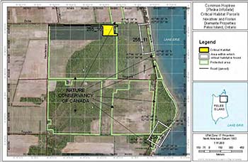
Figure 8: Location and extent of critical habitat parcel #255_14 for Common Hoptree
Critical habitat does not include existing infrastructure, existing cultivated areas, unnatural vegetation types, unvegetated beach/bar and bedrock, or areas in or adjacent to anthropogenic features where the presence of Common Hoptree is opportunistically related to the existence of these features, as described in Section 7.1.
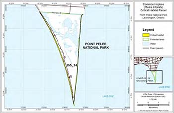
Figure 9: Location and extent of critical habitat parcel #255_17, #225_18, #225_19, and #225_20 for Common Hoptree
Critical habitat does not include existing infrastructure, existing cultivated areas, unnatural vegetation types, unvegetated beach/bar and bedrock, or areas in or adjacent to anthropogenic features where the presence of Common Hoptree is opportunistically related to the existence of these features, as described in Section 7.1.
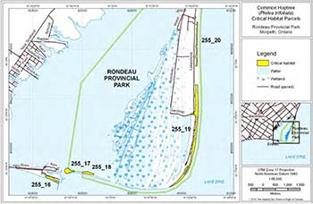
Figure 10: Area within which critical habitat for Common Hoptree is found (critical habitat parcel #255_2)
Please refer to Section 7.1 for the description of biophysical attributes to help locate the critical habitat within this area. Critical habitat does not include existing infrastructure, existing cultivated areas, unnatural vegetation types, unvegetated beach/bar and bedrock, or areas in or adjacent to anthropogenic features where the presence of Common Hoptree is opportunistically related to the existence of these features, as described in Section 7.1.
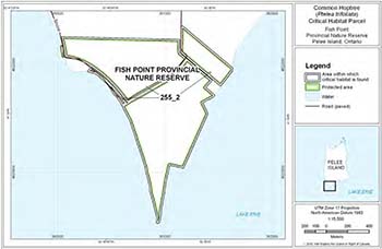
Figure 11: Area within which critical habitat for Common Hoptree is found (critical habitat parcel #255_12)
Please refer to Section 7.1 for the description of biophysical attributes to help locate the critical habitat within this area. Critical habitat does not include existing infrastructure, existing cultivated areas, unnatural vegetation types, unvegetated beach/bar and bedrock, or areas in or adjacent to anthropogenic features where the presence of Common Hoptree is opportunistically related to the existence of these features, as described in Section 7.1.
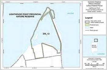
Figure 12: Location and extent of critical habitat parcel #255_16 for Common Hoptree
Critical habitat does not include existing infrastructure, existing cultivated areas, unnatural vegetation types, unvegetated beach/bar and bedrock, or areas in or adjacent to anthropogenic features where the presence of Common Hoptree is opportunistically related to the existence of these features, as described in Section 7.1.
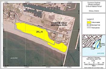
Figure 13: Location and extent of critical habitat parcel #255_8 for Common Hoptree
Critical habitat does not include existing infrastructure, existing cultivated areas, unnatural vegetation types, unvegetated beach/bar and bedrock, or areas in or adjacent to anthropogenic features where the presence of Common Hoptree is opportunistically related to the existence of these features, as described in Section 7.1.
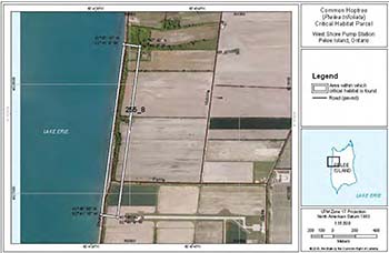
Figure 14: Area within which critical habitat for Common Hoptree is found (critical habitat parcel #255_13)
Please refer to Section 7.1 for the description of biophysical attributes to help locate the critical habitat within this area. Critical habitat does not include existing infrastructure, existing cultivated areas, unnatural vegetation types, unvegetated beach/bar and bedrock, or areas in or adjacent to anthropogenic features where the presence of Common Hoptree is opportunistically related to the existence of these features, as described in Section 7.1.
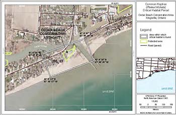
Figure 15: Area within which critical habitat for Common Hoptree is found (critical habitat parcel #255_15)
Please refer to Section 7.1 for the description of biophysical attributes to help locate the critical habitat within this area. Critical habitat does not include existing infrastructure, existing cultivated areas, unnatural vegetation types, unvegetated beach/bar and bedrock, or areas in or adjacent to anthropogenic features where the presence of Common Hoptree is opportunistically related to the existence of these features, as described in Section 7.1.
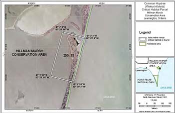
Figure 16: Area within which critical habitat for Common Hoptree is found (critical habitat parcel #255_21)
Please refer to Section 7.1 for the description of biophysical attributes to help locate the critical habitat within this area. Critical habitat does not include existing infrastructure, existing cultivated areas, unnatural vegetation types, unvegetated beach/bar and bedrock, or areas in or adjacent to anthropogenic features where the presence of Common Hoptree is opportunistically related to the existence of these features, as described in Section 7.1.
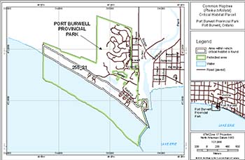
Figure 17: Area within which critical habitat for Common Hoptree is found (critical habitat parcel #255_22 and #225_23)
Please refer to Section 7.1 for the description of biophysical attributes to help locate the critical habitat within these areas. Critical habitat does not include existing infrastructure, existing cultivated areas, unnatural vegetation types, unvegetated beach/bar and bedrock, or areas in or adjacent to anthropogenic features where the presence of Common Hoptree is opportunistically related to the existence of these features, as described in Section 7.1.
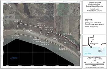
Figure 18: Area within which critical habitat for Common Hoptree is found (critical habitat parcel #255_24)
Please refer to Section 7.1 for the description of biophysical attributes to help locate the critical habitat within this area. Critical habitat does not include existing infrastructure, existing cultivated areas, unnatural vegetation types, unvegetated beach/bar and bedrock, or areas in or adjacent to anthropogenic features where the presence of Common Hoptree is opportunistically related to the existence of these features, as described in Section 7.1.
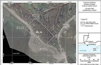
Figure 19: Area within which critical habitat for Common Hoptree is found (critical habitat parcel #255_25)
Please refer to Section 7.1 for the description of biophysical attributes to help locate the critical habitat within this area. Critical habitat does not include existing infrastructure, existing cultivated areas, unnatural vegetation types, unvegetated beach/bar and bedrock, or areas in or adjacent to anthropogenic features where the presence of Common Hoptree is opportunistically related to the existence of these features, as described in Section 7.1.
Figure 20: Area within which critical habitat for Common Hoptree is found (critical habitat parcel #255_26)
Please refer to Section 7.1 for the description of biophysical attributes to help locate the critical habitat within this area. Critical habitat does not include existing infrastructure, existing cultivated areas, unnatural vegetation types, unvegetated beach/bar and bedrock, or areas in or adjacent to anthropogenic features where the presence of Common Hoptree is opportunistically related to the existence of these features, as described in Section 7.1.
Figure 21: Area within which critical habitat for Common Hoptree is found (critical habitat parcel #255_27 and #225_28)
Please refer to Section 7.1 for the description of biophysical attributes to help locate the critical habitat within these areas. Critical habitat does not include existing infrastructure, existing cultivated areas, unnatural vegetation types, unvegetated beach/bar and bedrock, or areas in or adjacent to anthropogenic features where the presence of Common Hoptree is opportunistically related to the existence of these features, as described in Section 7.1.
Figure 22: Area within which critical habitat for Common Hoptree is found (critical habitat parcel #255_29 and #228_30)
Please refer to Section 7.1 for the description of biophysical attributes to help locate the critical habitat within these areas. Critical habitat does not include existing infrastructure, existing cultivated areas, unnatural vegetation types, unvegetated beach/bar and bedrock, or areas in or adjacent to anthropogenic features where the presence of Common Hoptree is opportunistically related to the existence of these features, as described in Section 7.1.
Figure 23: Area within which critical habitat for Common Hoptree is found (critical habitat parcel #255_31)
Please refer to Section 7.1 for the description of biophysical attributes to help locate the critical habitat within this area. Critical habitat does not include existing infrastructure, existing cultivated areas, unnatural vegetation types, unvegetated beach/bar and bedrock, or areas in or adjacent to anthropogenic features where the presence of Common Hoptree is opportunistically related to the existence of these features, as described in Section 7.1.
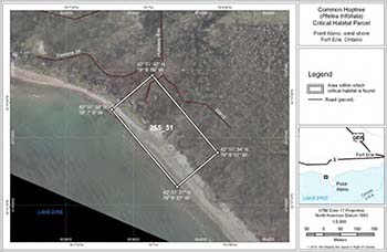
Figure 24: Area within which critical habitat for Common Hoptree is found (critical habitat parcel #255_32)
Please refer to Section 7.1 for the description of biophysical attributes to help locate the critical habitat within this area. Critical habitat does not include existing infrastructure, existing cultivated areas, unnatural vegetation types, unvegetated beach/bar and bedrock, or areas in or adjacent to anthropogenic features where the presence of Common Hoptree is opportunistically related to the existence of these features, as described in Section 7.1.
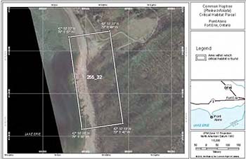
Figure 25: Area within which critical habitat for Common Hoptree is found (critical habitat parcel #255_33)
Please refer to Section 7.1 for the description of biophysical attributes to help locate the critical habitat within this area. Critical habitat does not include existing infrastructure, existing cultivated areas, unnatural vegetation types, unvegetated beach/bar and bedrock, or areas in or adjacent to anthropogenic features where the presence of Common Hoptree is opportunistically related to the existence of these features, as described in Section 7.1.
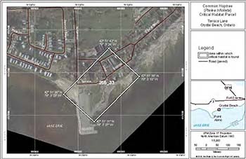
Figure 26: Area within which critical habitat for Common Hoptree is found (critical habitat parcel #255_34 and #255_35)
Please refer to Section 7.1 for the description of biophysical attributes to help locate the critical habitat within this area. Critical habitat does not include existing infrastructure, existing cultivated areas, unnatural vegetation types, unvegetated beach/bar and bedrock, or areas in or adjacent to anthropogenic features where the presence of Common Hoptree is opportunistically related to the existence of these features, as described in Section 7.1.
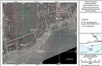
Figure 27: Area within which critical habitat for Common Hoptree is found (critical habitat parcel #255_36)
Please refer to Section 7.1 for the description of biophysical attributes to help locate the critical habitat within this area. Critical habitat does not include existing infrastructure, existing cultivated areas, unnatural vegetation types, unvegetated beach/bar and bedrock, or areas in or adjacent to anthropogenic features where the presence of Common Hoptree is opportunistically related to the existence of these features, as described in Section 7.1.
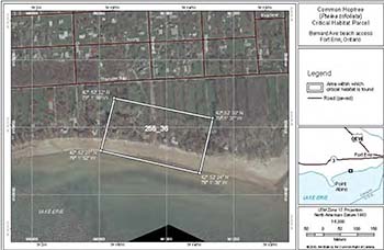
Figure 28: Area within which critical habitat for Common Hoptree is found (critical habitat parcel #255_37)
Please refer to Section 7.1 for the description of biophysical attributes to help locate the critical habitat within this area. Critical habitat does not include existing infrastructure, existing cultivated areas, unnatural vegetation types, unvegetated beach/bar and bedrock, or areas in or adjacent to anthropogenic features where the presence of Common Hoptree is opportunistically related to the existence of these features, as described in Section 7.1.
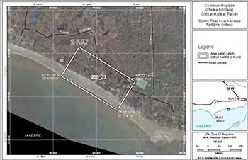
Figure 29: Area within which critical habitat for Common Hoptree is found (critical habitat parcel #255_38)
Please refer to Section 7.1 for the description of biophysical attributes to help locate the critical habitat within this area. Critical habitat does not include existing infrastructure, existing cultivated areas, unnatural vegetation types, unvegetated beach/bar and bedrock, or areas in or adjacent to anthropogenic features where the presence of Common Hoptree is opportunistically related to the existence of these features, as described in Section 7.1.
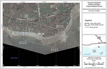
Figure 30: Area within which critical habitat for Common Hoptree is found (critical habitat parcel #255_39)
Please refer to Section 7.1 for the description of biophysical attributes to help locate the critical habitat within this area. Critical habitat does not include existing infrastructure, existing cultivated areas, unnatural vegetation types, unvegetated beach/bar and bedrock, or areas in or adjacent to anthropogenic features where the presence of Common Hoptree is opportunistically related to the existence of these features, as described in Section 7.1.
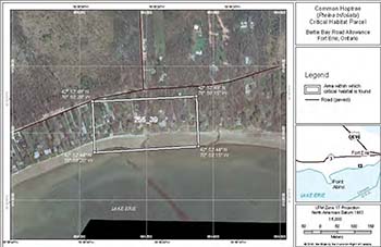
Figure 31: Area within which critical habitat for Common Hoptree is found (critical habitat parcel #255_40)
Please refer to Section 7.1 for the description of biophysical attributes to help locate the critical habitat within this area. Critical habitat does not include existing infrastructure, existing cultivated areas, unnatural vegetation types, unvegetated beach/bar and bedrock, or areas in or adjacent to anthropogenic features where the presence of Common Hoptree is opportunistically related to the existence of these features, as described in Section 7.1.
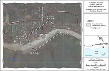
Figure 32: Area within which critical habitat for Common Hoptree is found (critical habitat parcel #255_42)
Please refer to Section 7.1 for the description of biophysical attributes to help locate the critical habitat within this area. Critical habitat does not include existing infrastructure, existing cultivated areas, unnatural vegetation types, unvegetated beach/bar and bedrock, or areas in or adjacent to anthropogenic features where the presence of Common Hoptree is opportunistically related to the existence of these features, as described in Section 7.1.
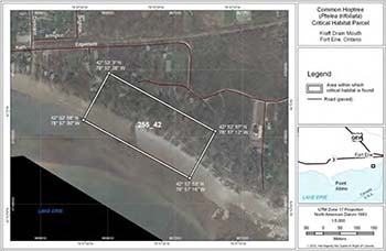
Figure 33: Area within which critical habitat for Common Hoptree is found (critical habitat parcel #255_43)
Please refer to Section 7.1 for the description of biophysical attributes to help locate the critical habitat within this area. Critical habitat does not include existing infrastructure, existing cultivated areas, unnatural vegetation types, unvegetated beach/bar and bedrock, or areas in or adjacent to anthropogenic features where the presence of Common Hoptree is opportunistically related to the existence of these features, as described in Section 7.1.
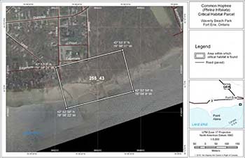
Figure 34: Area within which critical habitat for Common Hoptree is found (critical habitat parcel #255_41)
Please refer to Section 7.1 for the description of biophysical attributes to help locate the critical habitat within this area. Critical habitat does not include existing infrastructure, existing cultivated areas, unnatural vegetation types, unvegetated beach/bar and bedrock, or areas in or adjacent to anthropogenic features where the presence of Common Hoptree is opportunistically related to the existence of these features, as described in Section 7.1.
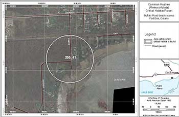
Figure 35: Location and extent of critical habitat parcel #255_1 for Common Hoptree
Critical habitat does not include existing infrastructure, existing cultivated areas, unnatural vegetation types, unvegetated beach/bar and bedrock, or areas in or adjacent to anthropogenic features where the presence of Common Hoptree is opportunistically related to the existence of these features, as described in Section 7.1.
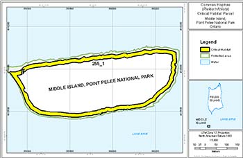
Appendix C: Populations known or suspected to be cultivated
Essex County
- Hillman Marsh canoe launch (NHIC unpub. data, Lebedyk pers. comm. 2010, Oldham pers. comm. 2010).
Lambton County
- Ausable River Cut Conservation Authority (Woodliffe pers. comm. 2010).
Elgin County
- Aylmer (Ambrose and Aboud 1984).
Middlesex County
- University of Western Campus, Thames River, and waste places, London (Ambrose and Aboud 1984).
Regional Municipality of Niagara
- Niagara Parks Commission School of Horticulture and possibly other trees in the vicinity (Ambrose and Aboud 1984).
- Upper Whirlpool Woods – two saplings planted by the Niagara Parks Commission in 2003 or 2004 with funding from the Habitat Stewardship Program (Ritchie pers. comm. 2010).
- Fonthill – var. mollis at edge of a Norway Spruce shelter belt, near Woodstream and Forest Hill Boulevards (Ambrose and Aboud 1984).
- Ridgeville – 1.5 km north northwest – edge of Norway Spruce shelterbelt (Ambrose and Aboud 1984), near the site of a plantation (OMNR unpub. data) and former tree nursery.
- Ridgeville Cemetery – now extirpated (Ambrose and Aboud 1984).
Municipality of Hamilton-Wentworth
- Hamilton Harbour – shrubby hillside (Ambrose and Aboud 1984).
Metro Toronto
- Don Valley and other waste places and ravines (Ambrose and Aboud 1984).
Quebec
12-15. Four populations (Rousseau 1974, Ambrose and Aboud 1984, Ambrose 2002).
Footnotes
- footnote[1] Back to paragraph Ambrose (2002) reported a scarcity of very large individuals and surmised a high turnover within populations.
- footnote[2] Back to paragraph Deciduous trees shed their leaves each year.
- footnote[3] Back to paragraph In dioecious plants, male and female flowers are found on separate individuals.
- footnote[4] Back to paragraph An extirpated designation means that the species has been confirmed to no longer exist at a site.
- footnote[5] Back to paragraph An historic designation means the species is previously known from the site, but has not been verified within the last 20 years.
- footnote[6] Back to paragraph Xeric plants require only a small amount of moisture.
- footnote[7] Back to paragraph In the Great Lakes basin, “alvar” refers to naturally open areas with shallow soils over relatively flat, limestone bedrock, with trees absent or at least not forming a continuous canopy (Reschke et al. 1999, Brownell and Riley 2000).
- footnote[8] Back to paragraph Allelopathic plants suppress or inhibit the growth of other plants through the release of chemical toxins.
- footnote[9] Back to paragraph An adventive species is not native or fully established in a new area.
- footnote[10] Back to paragraph Repatriation restores a species to a location where it was formerly found, but is not currently present.
- footnote[11] Back to paragraph Augmentation adds individuals of a species to an existing population in order to increase population size.
- footnote[12] Back to paragraph Graminoid refers to grasses.
- footnote[13] Back to paragraph ELC is a land and resource classification system that describes and delineates ecosystem units based on ecological factors including vegetation, soil, and geological conditions (Lee et al. 1998).
- footnote[14] Back to paragraph Given that the maximum-recorded DBH for Common Hoptree in Canada is 24 cm (Middle Island, Ontario [Waldron 2003]), the maximum critical root zone is then calculated to be 9 m (24 cm x 36 = 8.64 m rounded up to the nearest metre). This is supported by a 7.9 m rooting radius reported for an 18 year old tree of a species belonging to the same family (Rutaeae) as Common Hoptree (Stone and Kalisz 1990).
- footnote[15] Back to paragraph Diameter at breast height is the diameter of a tree as measured 1.3 m above ground level.
- footnote[16] Back to paragraph ELC Code based on ELC Provincial Catalogue 8 (Lee 2004).