Dunmore Township Balsam Fir Outwash Deposit Conservation Reserve Management Statement
This document provides policy direction for the protection, development and management of the Dunmore Township Balsam Fir Outwash Deposit Conservation Reserve and its resources.
August 2004
Kirkland Lake District
Ministry of Natural Resources
Approval statement
I am pleased to approve this Statement of Conservation Interest (SCI) for the Dunmore Township Balsam Fir Outwash Deposit Conservation Reserve.
Direction for establishing, planning and managing conservation reserves is defined under the Public Lands Act, the Ontario’s Living Legacy Land Use Strategy, and other applicable policies. The specific direction for managing this Conservation Reserve is in the form of a basic SCI, which defines the area to which the plan applies, provides the purpose for which the Conservation Reserve has been proposed, and outlines the Ministry of Natural Resources’ management intent for the protected area. This SCI has been created with input from program specialists within Kirkland Lake District.
This SCI will provide guidance for the management of the conservation reserve and the basis for the ongoing monitoring of activities. More detailed direction at this time is not anticipated. Should significant facility development be considered or complex issues arise requiring additional studies, more defined management direction, or special protection measures, than a more detailed Resource Management Plan will be prepared with full public consultation.
Public and Aboriginal consultation occurred prior to the regulation of this Conservation Reserve. Furthermore, the public, Aboriginals and other interested parties were notified during a 30 day period commencing November 20, 2004 concerning a draft of this SCI. Comments from the notification period have been considered in the development of this document.
The conservation reserve will be managed under the jurisdiction of the Kirkland Lake/Claybelt Area Supervisor of the Ministry of Natural Resources, Kirkland Lake District.
Plan authors:
Jennifer Telford and Jody Bissett
Ontario’s Living Legacy Resource Managers
Kirkland Lake District
Approved by: Corrinne Nelson, District Manager
Date: March 24, 2005
Approved by: Rob Galloway, Regional Director
Date: April 24, 2005
1.0 Introduction
Ontario’s network of natural heritage sites has been established to protect and conserve areas representative of the diversity of the natural regions of the province, including species, habitats, features and ecological systems which comprise that natural diversity. Protected natural heritage areas are a key component in sustainable management of natural resources. They ensure that representative sites within the larger sustainably managed landscape are permanently retained in their natural state.
Natural heritage areas are considered to be sensitive, requiring protection from incompatible activities if their values are to endure over time. The Ministry of Natural Resources (MNR) has established conservation reserves as a new tool to offer protection for these areas on public lands, while permitting many traditional public lands uses to continue. Such uses include the traditional activities of Aboriginal Peoples.
Ontario’s Living Legacy Land Use Strategy (OLL LUS) (MNR, 1999) and the Crown Land Use Policy Atlas sets the direction for the administration and management of parks and protected areas on Crown lands within three planning regions; the Boreal West, Boreal East and Great Lakes - St. Lawrence areas. This strategy’s natural heritage objectives include protection of natural and cultural heritage values and the provision of opportunities for outdoor recreation, heritage appreciation and tourism (MNR, 1999).
Protected areas designated within the OLL LUS (MNR, 1999) have been selected based on their representation of the spectrum of the province’s ecosystems and natural features including both biological and geological features, while minimizing impacts on other land uses. Representation is described using landform and vegetation (L:V) combinations based on Hill’s (1959) site district concept.
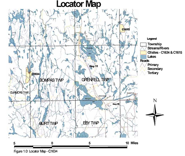
The Dunmore Township Balsam Fir Outwash Deposit (DTBFOD) Conservation Reserve (C1634) is a 203 ha parcel of Crown land that is situated approximately 30 kilometers west of the Town of Kirkland Lake, within Dunmore and Bompas Townships (Locator Maps, Appendix #7). These townships are located in the Kirkland Lake District within the MNR’s Northeast Region. This Conservation Reserve was regulated on April 6th, 2001 and will be managed under a Statement of Conservation Interest (SCI).
SCI documents consist of brief management plans and are the minimum level of management direction established for any conservation reserve. This SCI will govern the lands and waters within the regulated boundary of the Dunmore Township Balsam Fir Outwash Deposit Conservation Reserve. However, to ensure MNR protection objectives are being fully met within the Conservation Reserve, the surrounding landscape and related activities should consider site’s objectives and heritage values. In addition, it is the intent of this SCI to create public awareness that will promote responsible stewardship of the protected area and surrounding lands. MNR District staff, along with management partners such as Ontario Parks, industry and local governments, will pursue and advance sound environmental, economic and social strategies and policies related to the protection of conservation reserves and provincial parks.
The purpose of this SCI is to identify and describe the values of the Dunmore Township Balsam Fir Outwash Deposit Conservation Reserve and outline the Ministry’s management intent for the Conservation Reserve. The management direction will protect the site’s natural heritage values and demonstrate its compatibility within the larger sustainable landscape. This direction will comply with land use intent as stated by the OLL Land Use Strategy (MNR, 1999).
2.0 Goals and objectives
2.1 Goal of Statement of Conservation Interest
This Statement of Conservation Interest is intended to guide the management decisions that will ensure the Dunmore Township Balsam Fir Outwash Deposit Conservation Reserve remains a protected natural heritage value on public lands, while permitting compatible land use strategies.
2.2 Objectives of SCI
2.2.1 Short term objectives
The short-term objectives are to identify the State of Resource with respect to natural heritage values and current land use activities for the Dunmore Township Balsam Fir Outwash Deposit Conservation Reserve. A priority will be placed on the protection of the site’s natural values via specific guidelines, strategies and prescriptions detailed in this plan. Finally, legislated planning requirements will be met (i.e. SCI development within three years of regulation).
2.2.2 Long term objectives
The long-term objectives will be to establish representative targets (e.g. future forest conditions) and validate the site as a potential scientific benchmark. To ensure protection of natural and cultural heritage features and values, this SCI will establish an evaluation process to address future new uses and commercial activities associated with them (e.g. Test of Compatibility Procedural Guideline B in Conservation Reserve Policy PL 3.03.05, Appendix #4).
3.0 Management planning
3.1 Planning area
The planning area for this site will consist of the area within the regulated boundary for the Dunmore Township Balsam Fir Outwash Deposit Conservation Reserve (Locator Maps, Appendix #7). This landbase will form the area directly influenced by this SCI. The SCI will recognize the protection of values within the planning area; however, to fully protect values within the conservation reserve, the lands beyond the regulated boundary may require additional consideration within larger land use or resource management plans. Nevertheless, any strategies noted within this plan related to the site’s boundary or beyond will need to be presented for consideration within a larger planning context.
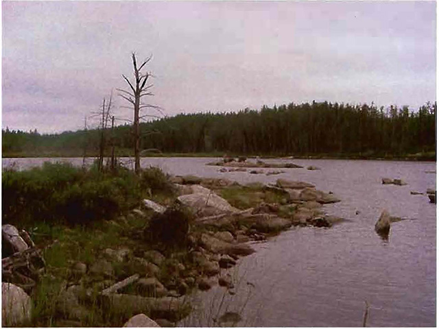
Figure 2.0: Rib Lake, Dunmore Township Balsalm Fir Outwash Deposit CR
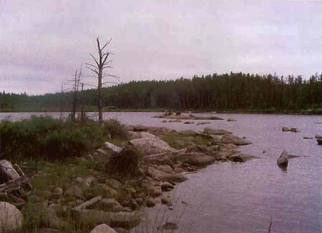
Photo taken July 2003
3.2 Management planning context
The Dunmore Township Balsam Fir Outwash Deposit Conservation Reserve was first designated as a candidate conservation reserve by MNR in the OLL Proposed Land Use Strategy (MNR March, 1999) and ultimately as a conservation reserve in the final OLL Land Use Strategy (MNR, 1999). The site was regulated with the filing of Ontario Regulation 86/01 made under the Public Lands Act on April 6, 2001. The management and planning direction for this site will follow the OLL LUS (MNR, 1999) as well as this SCI. The area encompassed by this site has been removed from the Timiskaming Forest Alliance Inc. Sustainable Forest License (SFL) landbase.
The regulation of this Conservation Reserve will prohibit the following commercial activities; commercial forest harvest, pat/aggregate extraction, mining or hydroelectric power development (MNR, 1999). Traditional activities within this reserve may continue such as fishing, hunting, trapping, baitfish and existing bear management. This SCI document and future management will resolve conflicts regarding incompatibility between uses and to ensure that identified values are adequately protected.
This SCI will only address known issues or current proposals with respect to permitted uses or potential economic opportunities brought forward to the District Manager during this planning stage. However, in terms of approving future permitted uses and/or development(s), there are established mechanisms in place to address such proposals. Any future proposals will be reviewed using the Procedural Guideline B - Land Uses - Test of Compatibility Public Lands Act Policy PL 3.03.05 (MNR, 1997) (Appendix #4) or other standard MNR environmental screening processes.
Consideration of proposals pertaining to cultural resources may be screened through Conserving a Future for our Past: Archaeology, Land Use Planning & Development in Ontario, Section 3 (MCzCR, 1997), or in processes such as that used by MNR to establish Area of Concern (AOC) descriptions and prescriptions for cultural heritage resources within forest management plans (FMPs).
These planning tools will help refine the review process once the proposal satisfies the direction and intent of the Public Lands Act, associated policies and this planning document.
3.3 Planning process
Once a conservation reserve is passed into regulation, it must be determined what level of management planning is required to fulfill the protection targets. There are two policy documents involved. A Statement of Conservation Interest (SCI) is the minimal requirement for providing planning direction, a Resource Management Plan (RMP) deals with more complex issues where several conflicting demands are placed on the resources. The guidelines for the preparation of these documents are outlined in Procedural Guideline A - Resource Management Planning (Conservation Reserves Procedure PL3.03.05 Public Lands Act). The appropriate plan must be completed within three years of the regulation date.
For current planning purposes, the Dunmore Township Balsam Fir Outwash Deposit Conservation Reserve will be managed under the auspices of a Statement of Conservation Interest (SCI). Interested parties from the private and public sector were consulted during the planning process, from candidate conservation reserve to regulation. The public was widely consulted during the regulation process and further consultation is not required at this time (Appendix #1). In addition, a public notification of a draft of this SCI document occurred for a period of 30 days commencing November 20, 2004 (Appendix #2).
The revised SCI was reviewed by the Kirkland Lake District Manager (DM). Upon approval by the DM the SCI was presented to the Regional Director (RD) for final approval.
Following RD approval, interested public, user groups and industry were notified that the Statement of Conservation Interest for the Dunmore Township Balsam Fir Outwash Deposit Conservation Reserve was approved.
Public consultation will be solicited as part of any future reviews of land use proposals that would require new decisions to be made. In addition, any new significant management direction considered will be published on the Environmental Bill of Rights Registry (EBR).
The SCI is a planning document that will provide background information, identify values to be protected and establish management guidelines for use in the administration of the reserve.
The implementation of the SCI will be the mandate of the MNR at the District level; however, associations with various partners may be sought to assist in the delivery. This SCI is a working document, and as a result, it may be necessary to make revisions to it from time to time.
4.0 Background information
4.1 Location and site description
4.1.1 Location
The following table describes the location and provides administrative details for the Dunmore Township Balsam Fir Outwash Deposit Conservation Reserve:
Table 1.0: Location data and administrative details
| Name | Dunmore Township Balsam Fir Outwash Deposit Conservation Reserve |
|---|---|
| Eco. Region- Eco. District (Hills, 1959; Crins, 2000) | Eco. Region 3E, Eco. District 6 |
| MNR administrative region/district area | Northeast Region/Kirkland Lake District in the Kirkland Lake/Claybelt Area |
| Total area | 203 ha |
| UTM co-ordinates | 17 543926 5332466 |
| Nearest town/municipality | West of Kirkland Lake |
| Township(s) | Dunmore, Bompas |
| OBM numbers | 5400/53300 |
| Topographical map name/number | Kirkland Lake 42 A/01 |
| Wildlife management unit | 28 |
| Forest management unit | Timiskaming Forest |
4.1.2 Site description
4.1.2.1. Physical description
The Dunmore Township Balsam Fir Outwash Deposit Conservation Reserve, which encompasses 203 hectares of land, is located approximately 30 km west of the Town of Kirkland Lake within Dunmore and Bompas Townships in the District of Timiskaming (Locator Map, Appendix #7). The Conservation Reserve is located in Hills’ Kirkland Lake Ecodistrict 3E-6 (Hills, 1959), which is characterized by moderately to gently rolling bedrock, generally covered by deep deposits of clay, silt and sand. Almost the entire CR is made up of moderately broken outwash deposits, with only a small section in the south-east corner consisting of lacustrine deposits (Map 1b, Appendix #8). Based on aerial photograph interpretation by Rik Kristjansson, a Geoscientist, the CR is underlain by area of bedrock-drift complex with small areas of till deposits and organic deposits. For more information relating to the geology of the site refer to Earth Science Inventory, Appendix #9.
Most of the site’s boundaries are formed by a series of line segments. Only the boundaries to the south and north are biological in nature. The northern boundary follows the shoreline of Rib Lake and the southern boundary follows an unnamed creek. Dunmore Township Balsam Fir Outwash Deposit Conservation Reserve is located within the Missinaibi-Cabonga Boreal Forest Region (Rowe, 1972). The Missinaibi-Cabonga Forest is characterized by mixed forests of balsam fir, black spruce and white birch, with scattered spruce and trembling aspen. Jack pine, tamarack and cedar can also be found within the region.
The section of forest contained within the Dunmore Township Balsam Fir Outwash Deposit Conservation Reserve is largely made up of black spruce (Map 2a, Appendix #8). The black spruce is found along the site’s western boundary and extends into the center. A small stand is also located in the northeast corner of the CR. During aerial reconnaissance of the site it was discovered that the black spruce stand in the center of the site contains trembling aspen and white birch as well. This information was not provided in the Forest Resource Inventory (FRI) data. Treed muskeg is found in the western and southern portions of the site and open muskeg surrounds Rib Creek, which runs through the center of the CR. The rest of the CR contains mixed woods of jack pine, white birch, poplar and balsam fir with a few pure jack pine stands along the eastern border. The aerial survey showed balsam fir as a regenerating species amongst poplar and jack pine stands.
Stocking is defined as an expression of the adequacy of tree cover of an area, or how well trees are distributed across the site (OMNR, 2003). Stocking is usually expressed as a percent value, the higher the percent the more even the distribution pattern. The vast majority of stocking levels in this site are between 60-80% (Map2b, Appendix #8). Most of the forest stands within the site are between 30-59 and 60-89 years old. There is an old growth stand (90-119 years) in the northwest corner of the site (Map 2c, Appendix #8).
The areas of treed and open muskeg add to the wetland diversity of the Dunmore Township Balsam Fir Outwash Deposit Conservation Reserve. The wetlands in the site are found mainly along Rib Creek. Open bog, a sheltered open water marsh, poor fen, poor shore fen and a beaver meadow make up the wetlands in the center and southern areas of the site. To the north, an open water marsh and conifer swamp exists along the shores of Rib Lake. In the southern tip of the CR a small unnamed lake exists, surrounded by a beaver meadow (Map 3b, Appendix #8).
4.2 Administrative description
The legal boundaries of the Dunmore Township Balsam Fir Outwash Deposit Conservation Reserve were "filed on January 12, 2001 with the Office of the Surveyor General, Ministry of Natural Resources in Peterborough, Ontario. This site was passed into regulation on April 6, 2001(O. Reg. 86/01) (Regulation Maps, Appendix #10). This Conservation Reserve falls within the Kirkland LakeClaybelt Area of the Kirkland Lake District and will be administered by the Kirkland Lake-Claybelt Area Supervisor. The site is located within the Timiskaming Forest Alliance Inc. Sustainable Forest License (SFL) area.
4.3 History of site
Historically this site has been used for wildlife related activities, such as trapping and fishing. These activities continue today. Portions of two Bear Management Areas (KL-28-017 & KL-28-018) and two trap line areas (KL047 & KL055), as well as a moose wintering area are located within the CR boundaries (Map 3a, Appendix #8). The numerous small lakes and creeks within the site contribute to the potential for recreational activities such as fishing, hunting and wildlife viewing. During the aerial reconnaissance survey two hunting blinds were observed within the CR.
Some logging and silviculture work has taken place within the CR boundaries in the past 20 years. However, with the designation of this area as a conservation reserve, harvesting is no longer permitted within the official boundaries.
4.4 Inventories
The following table indicates the natural heritage inventories that have occurred or are required in the future.
Table 2.0: Inventory data status
| Type of inventory | Method | Date | Report |
|---|---|---|---|
| Life science | Aerial reconnaissance | August 2002 | Authors: J. Noordhof, J. Thompson, L. King, S. Longyear; OMNR |
| Earth science | Aerial reconnaissance | August 2002 | Author: R. Kristjansson; OMNR |
| Recreation | Aerial reconnaissance | June 2002 | Author: J. Telford; OMNR |
5.0 State of the resource
Representation:
The Dunmore Township Balsam Fir Outwash Deposit Conservation Reserve is located in the mid-humid, mid-boreal forest climate type (Hills, 1959; Poser, 1992). Conifers, such as black spruce, jack pine and balsam fir, dominate the Dunmore Township Balsam Fir Outwash Deposit Conservation Reserve. In most areas of the site, white birch and trembling aspen are the complementary tree species found. There are a few pure jack pine stands in the CR along the eastern boundary.
Logging has occurred outside the site in the recent past and a few small areas within the site have been logged and replanted within the last 20 years. Areas to the east of the Conservation Reserve have been logged including a few sections on the eastern boundary. Jack pine is regenerating successfully and the old logging roads into the eastern section of the CR are now completely overgrown. There is also a harvest area just outside the northern boundary. Access to the CR from the north can only be gained by walking along an old logging road and then cutting into the dense brush for approximately 400m to the shores of Rib Lake. Due to the limited access of this CR, the level of disturbance has remained low.
Forest age distribution within the Conservation Reserve ranges from a high of 90-119 years (old growth) in the northwest corner to a low of 0-29 years along the eastern boundary. The majority of age distribution falls within the 60-89 year category (Map2c, Appendix #8).
The wetland sites within the Conservation Reserve are quite extensive. Approximately one third of the CR, 163 acres, from the banks of Rib Creek to the shores of an unnamed lake in the southern end of the site, is wetlands (Map 3b, Appendix #8).
Quality of representation:
The quality of the representation or the current characteristics of the natural features found within a conservation reserve are as important as the overall representative features that are being protected. A number of factors are considered in evaluating a site and they include the following criteria: diversity, condition, ecological factors, special features and current land use activities.
a) Diversity:
Diversity is a measure of the site’s life and earth science heterogeneity. The evaluation is based on the number and range (variety) of the natural landscape features and landforms for earth science values and the relative richness and evenness of the site’s life science components. Natural landscapes and known generalized vegetation communities will be the scale used for this SCI. Future aerial or ground reconnaissance surveys will enhance the MNR’s knowledge of these features and possibly allow verification at a lower scale (e.g. species assemblages).
There are two major landform or earth science features present within the site including moderately broken outwash deposit and lacustrine deposit (Map 1b, Appendix #8). The original gap analysis for this site found eight landforms with a site size of 126 ha however no associated diversity rating was provided. The Dunmore Township Balsam Fir Outwash Conservation Reserve has since been enlarged to a size of 203 ha and so, in all likelihood, has an increased level of diversity, however a landform: vegetation analysis using the site’s current size and configuration has not yet been completed.
The FRI forest community data was further grouped into Standard Forest Units (SFUs) (Map 2d, Appendix #8). This analysis resulted in five SFUs however the PJ1 SFU should not be included in the landform: vegetation analysis since these areas have been harvested. If we compare the four SFUs (PJ1 excluded) with Kristjansson (2002) landforms interpretation we see that there would be approximately seven landform: vegetation_combinations, however this is just a rough estimate and a landform: vegetation analysis for this site is still required. When considering the seven potential landform: vegetation combinations the diversity of the site is considered low. Diversity would have been slightly increased if developmental stages were considered in the grouping of FRI into SFUs. If developmental stages are included in the grouping of FRI into SFUs the number of SFUs would increase from 4 to 7 and would subsequently increase the number of landform: vegetation combinations.
Conifers, such as jack pine, black spruce and balsam fir, are the dominant tree species in the Conservation Reserve, with white birch and trembling aspen being the most common deciduous species (Map 2a, Appendix #8). Wetland communities are located in the center and along the western edge of the Reserve, with treed muskeg being the most prominent form of wetland (Map 3b, Appendix #8). The Conservation Reserve also contains a beaver meadow, open bog, thicket swamp and a cedar conifer swamp. The faunal diversity of the site is likely normal for the boreal forest region; however a more definitive assessment of floral and faunal diversity cannot be made at present given that only a reconnaissance level survey has been performed. A full biological inventory and evaluation would provide a more complete species list.
b) Condition:
Condition refers to the amount of disturbance that the site has experienced, including both human and natural types of disturbance. For this site, disturbance is rated at low to moderate. A section along the eastern side of the site was logged and re-planted with jack pine 10 to 20 years ago. The old logging roads leading to the eastern boundary of the site are completely overgrown, making access nearly impossible. Timber harvesting has occurred just outside the northern boundary of the site. The logging roads in this area provide access to the northern boundary of the site; however there are no trails that lead directly into the Conservation Reserve. Dead trees were spotted in the western part of the reserve during the reconnaissance survey, suggesting beaver activity.
c) Ecological factors:
Wherever possible, the site’s boundaries should be created to include the greatest diversity of life and earth science feature to provide the maximum ecological integrity. It should be ecologically self contained, bounded by natural features and include adequate area to buffer the core ecosystems from adjacent land use activities (OMNR, 1992). Ecological factors refer to the current design of the conservation reserve as noted by its size, shape, and buffering capacity to adjacent land use activities.
A large portion of this reserve is contained by vectored boundaries (i.e. straight line boundaries which are characterized mathematically by direction and magnitude, not by natural features). This type of boundary dominates the eastern, western and much of the southern boundary. Biological boundaries do exist along the northern and parts of the southern boundary. A section of the northern boundary follows the south to west shoreline of Rib Lake and part of the southern boundary follow an unnamed creek. These are the only natural boundaries for this site. Due to the strong presence of vectored boundaries many of the sites major forest communities are fragmented. This may diminish the sites ability to protect core values and also make the management and protection of the site a greater challenge. The size of the Conservation Reserve (203 ha) is also a concern for the protection of the areas ecological features, as a buffer zone around the core features is lacking. The small size and lack of major waterways and trails limits the recreational potential of this Conservation Reserve.
d) Special features:
The major features present within this Conservation Reserve are:
- The shoreline of Rib Lake.
- The wetland areas that extend the length of Rib Creek through the reserve.
- The balsam fir mixed wood forest along the southern shore of Rib Lake.
- A moose wintering area along the north-west shore of Rib Lake and a small section of a second moose wintering area in the southwest edge of the CR.
e) Current land use activities
A small number of uses are known to be associated with this site. Activities include ATVs use, fishing, hunting and trapping. There is also opportunity for backcountry hiking and nature observation; however with the lack of trails in the Reserve it is unknown whether people are utilizing the area for these activities at this time.
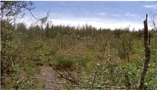
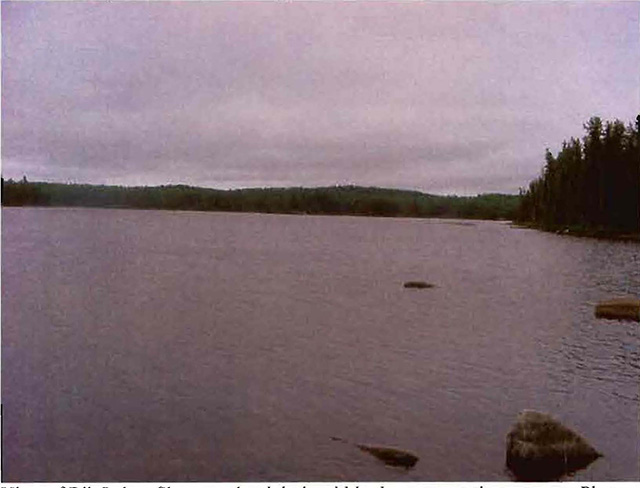
Figure 3.0: Rib Lake
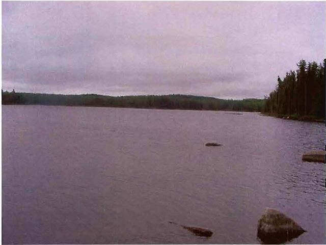
The shore on the right is part of the northern boundary of the Conservation Reserve.
Photo by Jennifer Telford, July 2003.
Summary:
The Dunmore Township Balsam Fir Outwash Deposit Conservation Reserve is a small site with a limited capacity for recreation. Access is limited to old logging roads, some of which are now overgrown. Disturbance within the Conservation Reserve has been restricted to a few areas that were logged a number of years ago. There are more recent clear cuts just outside of the site and as a result the northern sections of forest do not have a safeguard from adjacent activities.
The main features of interest within the reserve are; a moose wintering area, the presence of large and small mammals, extensive wetlands and an interesting semi-treed bog wetland complex. The most sensitive sections of the reserve are the wetlands, as extensive traffic may disturb or even destroy wetland vegetation.
Natural heritage representative features
This site consists of one small, unnamed lake, Rib Creek and the southern shore of Rib Lake. Moderately broken outwash deposits are the main landform present with a few lacustrine deposits located at the southern end of the site (Map 1b, Appendix #8). There are also a number of organic deposits associated with the wetland areas and the unnamed lake. Some pure jack pine stands and old growth white birch were observed during an aerial reconnaissance survey.
Table 3.0: Landform - vegetation (LV) types
| Landform | Vegetation |
|---|---|
| Lacustrine deposit | Black Spruce |
| Lacustrine deposit | Jack Pine |
| Lacustrine deposit | Treed Muskeg |
| Moderately broken outwash deposit | Treed Muskeg |
| Moderately broken outwash deposit | Jack Pine/White Birch True Mixed |
| Moderately broken outwash deposit | Poplar/Jack Pine True Mixed |
| Moderately broken outwash deposit | Balsam Fir Mixed Wood |
| Moderately broken outwash deposit | Jack Pine |
| Moderately broken outwash deposit | Black Spruce |
| Moderately broken outwash deposit | Poplar Mixed Wood |
Forest Resource Inventory (FRI) data
- Dominant species, wetlands, and depleted areas
- See Forest Communities Map (Map 2a, Appendix #8)
5.1 Social/economic interest in area
a) Linkage to local communities:
The Dunmore Township Balsam Fir Outwash Deposit Conservation Reserve is a 203 ha parcel of crown land that is situated west of Highway 11 and approximately 30 km west of Kirkland Lake, Ontario. The Conservation Reserve is located within Dunmore and Bompas townships (Locator Maps, Appendix #7). The site is the westernmost site in the Kirkland Lake 3E-6 Ecodistrict. Ecodistrict 3E-6 is found within the Lake Abitibi Ecoregion 3E.
Current uses are related to consumption of fish and wildlife resources and ATVs riding. Potential recreational activities could include snowmobiling, canoeing, camping and possible non-consumptive uses such as bird watching, photography or nature study.
b) Heritage estate contributions
The Dunmore Township Balsam Fir Outwash Deposit Conservation Reserve contributes to the province’s parks and protected areas system through its regulation, representation and the long-term management of natural heritage values. By allocating these lands to the parks and protected areas system, the province has ensured a certain level of permanence by distinguishing the site and its values from the broader general use or more extensively managed landscape. In addition, its natural features are, and will be available for present and future generations to enjoy and explore.
c) Aboriginal groups
Due to the relative proximity of the Dunmore Township Balsam Fir Outwash Deposit Conservation Reserve to the Matachewan First Nation’s Reserve, they have been consulted throughout the planning and implementation of this CR.
d) Mining interests:
This Conservation Reserve has no mining tenure within it. Mining and surface rights were withdrawn from staking within the conservation reserve’s boundaries under the Mining Act (RSO 1990 Chapter M.14). This interim protection was established in 1999 to ensure the core values of the site remain until the conservation reserve could be formally regulated in April of 2001.
e) Forest and fire management history:
This site has been affected by forest management activities. An aerial reconnaissance survey showed pre-OLL harvest areas slightly within and adjacent to the site. The harvested areas within the site are now regenerating with jack pine. Harvesting was completed prior to the OLL Land Use Strategy (MNR, 1999) and the interim protection standards.
The site has no recent burned areas within its boundary.
5.2 Natural heritage stewardship
Analysis of the life science targets based on landform/vegetation combinations have shown that the conservation reserve contains a minimum of seven landform: vegetation combinations. A total of nine separate forest communities were identified (Map 2a, Appendix #8) with old growth white birch present within the site (Map 5, Appendix #8). Jack pine, black spruce and balsam fir communities dominate the site with trembling aspen and white birch complementing the other forest communities (Table 3.0 - Vegetation Types). Finally, wetlands and the shoreline of Rib Lake further enhance the site’s natural heritage values and diversity. Various wetland types cover approximately one third of the Conservation Reserve.
Figure 4.0 Photo of an unnamed lake found within the Conservation Reserve
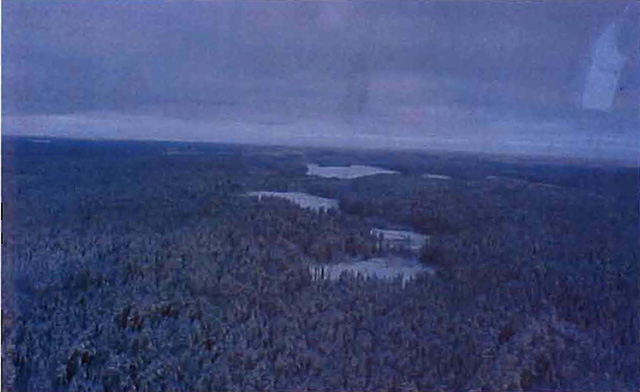
Photo by Erica Coulson. December 2000.
5.3 Fish and wildlife
Currently, no "fisheries information is available for Rib Lake or the other isolated lake and creeks within the site.
This area is used for hunting and trapping. There are two bear management areas (KL-28-017 & KL-28-018) and two trap line areas (KL047 & KL055) within the CR. The dominant forest stands, open wetland and bogs provide year round habitat for moose and other species. A variety of animals inhabit the site including black bear, moose, snowshoe hare, grouse and marten.
5.4 Cultural heritage stewardship
To date, a detailed assessment of cultural resources has not been carried out.
5.5 Land use/existing development
The Conservation Reserve is situated entirely on Crown Land and is unencumbered by any patented land, land use permits, leases or mining claims. Mining and surface rights have been withdrawn from the reserve (MNDM G-Plan M-0282 December 12, 2001) and no new claims will be allowed to be established within the CR boundaries.
5.6 Commercial land use
Present commercial use activities include two bear management areas (KL-28-017, KL-28-018) and two traplines (KL047, KL055) (Map 3a, appendix #8).
5.7 Tourism/recreation use/opportunities
Some of the features within this site associated with possible recreational use include large and small mammals, mixed forests, and aquatic flora and fauna. Existing recreational uses in this site and immediately surrounding the site include trapping, large game hunting, small game hunting, ATVs riding, snowmobiling, and possibly fishing. There is also potential for activities such as bird watching and nature study. The lack of major waterways and trails limit the recreational potential of this site.
For a more detailed report and summary of the recreational use and potential, refer to the Recreational Inventory Check-sheet (Appendix #3).
5.8 Client services
Currently, visitor services are limited to responding to inquiries regarding access, natural heritage features and boundaries. No formal information or interpretive facilities currently exist within the Conservation Reserve. Other client services include providing clients with maps, fact sheets, and other information gathered on the area, such as the Earth/Life Sciences and Recreational Inventory work.
6.0 Management guidelines
6.1 Management planning strategies
The land use intent outlined in the OLL LUS (MNR, 1999) provides context and direction for land use, resource management, and operational planning activities on Crown Land in the planning area and within OLL site boundaries. Commitments identified in the OLL LUS and current legislation (Policy 3.03.05 PLA) form the basis for land use within the Dunmore Township Balsam Fir Outwash Deposit Conservation Reserve. Management strategies for these uses must consider the short and long-term objectives for the conservation reserve.
For up to date information on permitted uses refer to the Crown Land Use Atlas (MNR, 2002) (Appendix #6).
Proposed new uses and development will be reviewed on a case-by-case basis. A Test of Compatibility, (Procedural Guideline B - Land Uses (PL 3.30.05), (Appendix #4) must be completed before proposals can be accepted. In all cases, ensuring that the natural values of the conservation reserve are not negatively affected by current and future activities will be the priority. Therefore any application for new specific uses will be carefully studied and reviewed.
6.2 “State of the Resource” management strategies
The development of this SCI and the long term management and protection of the Dunmore Township Balsam Fir Outwash Deposit Conservation Reserve will be under the direction of the MNR’s Kirkland Lake District, Kirkland Lake/Claybelt Area Supervisor. The following management strategies have been created to achieve the goal and objectives stated earlier in this management document.
Natural heritage stewardship
The management intent for Dunmore Township Balsam Fir Outwash Deposit Conservation Reserve is to allow for natural ecosystems, processes and features to operate undisturbed with minimal human interference while providing educational, research and recreational activities. Forest ecosystem renewal will only be entertained via a separate vegetation management plan. As part of any future vegetation management plan the site and its Site District will be reevaluated with respect to their known landform/vegetation features to determine if the past harvested areas could contribute additional landform/vegetation values to the Site District.
In addition, the vegetation management plan will need to determine but not be limited to:
- the restoration ecology objectives (e.g. representation) for the area in context with the Site District;
- consider current provincial strategies (e.g. management of white pine);
- consider larger long-term conservation reserve (e.g. recreational objectives) and possibly landscape objectives (e.g. contributions to landscape wildlife objectives).
The MNR recognizes fire as an essential process fundamental to the ecological integrity of conservation reserves. In accordance with existing Conservation Reserve Policy and the Forest Fire Management Strategy for Ontario, forest fire protection will be carried out as on surrounding lands.
Whenever feasible, the MNR fire program will endeavor to use “light on the land” techniques, which do not unduly disturb the landscape, in conservation reserves. Examples of “light on the land” techniques include limiting the use of heavy equipment and limiting the number of trees felled during fire response efforts.
Opportunities for prescribed burning to achieve ecological or resource management objectives may be considered. These management objectives will be developed with public consultation prior to any prescribed burning, and reflected in the document that provides management direction for this conservation reserve. Plans for any prescribed burning will be developed in accordance with the MNR Prescribed Burn Planning Manual, and the Class Environmental Assessment for Provincial Parks and Conservation Reserves (approval pending).
Defining compatible uses, enforcing regulations and monitoring and mitigating issues will protect all earth and life science features. Industrial activities such as commercial timber harvest and new hydro generation will not be permitted within the Conservation Reserve. Permits for fuel-wood will not be issued. New energy transmission, communication and transportation corridors or construction of facilities are not permitted within the boundaries of the conservation reserve. Such structures negatively impact the quality of the representative features that require protection. Alternatives should be reviewed via larger landscape planning processes. New roads for resource extraction will not be permitted. Other activities that do not pass a Test of Compatibility will be prohibited (MNR Policy 3.03.05, 1997).
The intentional introduction of exotic and/or invasive species will not be permitted. Programs may be developed to control forest insects and diseases where they threaten significant heritage, aesthetic, or economic values. Where control is desirable, it will be directed as narrowly as possible to the specific insect or disease. Biological or non-intrusive solutions should be applied whenever possible.
The collection/removal of vegetation and parts thereof will not be permitted; however, subject to a Test of Compatibility, the Area Supervisor may authorize such activities for purposes of rehabilitating degraded sites within the reserve, collecting seeds for maintaining genetic stock and/or for inventory or research purposes.
MNR will provide leadership and direction for maintaining the integrity of this site as a heritage estate. To ensure MNR protection objectives are fully met within the conservation reserve, activities on the surrounding landscape must consider the site’s objectives and heritage values. Research, education and interpretation will be encouraged to provide a better understanding of the management and protection of the natural heritage values and will be fostered through local and regional natural heritage programs, initiatives and partnerships.
The Conservation Reserve will be managed by allowing natural ecosystems, processes, and features to function normally, with minimal human interference.
Fish and wildlife
Fish and wildlife resources will continue to be managed in accordance with specific policies and regulations defined by the Ontario Ministry of Natural Resources under the Fish and Wildlife Conservation Act and the Kirkland Lake District, Kirkland Lake/Claybelt Area Supervisor.
Fishing and hunting are expected to continue at a low level of intensity. Any future trail development will require a Test of Compatibility.
Cultural heritage
When possible, the Ministry of Natural Resources will continue to work with the Ontario Ministry of Culture, Tourism and Recreation in identifying archaeological sites to be protected. To more fully manage and protect sites, the development of field surveys would be required. However, at this time additional field surveys within this Conservation Reserve are not recommended.
Development, research and education proposals may be considered in accordance with the Test of Compatibility and Conserving a Future for our Past: Archaeology, Land Use Planning & Development in Ontario, Section 3 (MCzCR, 1997).
Land use and development
The sale of lands within conservation reserves is not permitted as per the OLL LUS (MNR, 1999). Existing authorized trails can continue to be used and maintained, unless there are significant demonstrated conflicts. New trails will only be allowed if a Test of Compatibility is passed. Any new trail development will require an amendment to the SCI. The cutting of trees for non-commercial purposes (e.g. fuelwood) is not permitted except as required for approved development activity (e.g. trail, viewing site, etc.).
New roads for resource extraction will not be permitted. Abandoned forest extraction roads will not be actively maintained.
There are no other forms of tenure in the Conservation Reserve other than legal agreements with registered trappers and bear management area operators.
Traditional uses within the Conservation Reserve will continue to be permitted; however, the goal will be to resolve conflicts regarding incompatibility between uses and to ensure that identified values are adequately protected.
Commercial use
Commercial bear hunting (within BMA) operations may continue and the transfer of existing licenses is allowed, providing the activity has been licensed/permitted since January 1, 1992. Licences to provide Bear Hunting Services will not be issued in areas where issuance has not occurred since January 1, 1992.
Existing commercial fur harvesting operations are permitted to continue. New operations may be considered subject to a Test of Compatibility.
Aboriginal interests
Aboriginal and treaty rights will continue to be respected throughout the management of this Conservation Reserve. Any future proposal(s) and or decision(s) that have potential impact(s) on individual aboriginal values and or communities will involve additional consultation with the affected aboriginal groups.
Tourism/recreation
The earth and life science features and their protection shall be the overall theme for tourism. Small-scale infrastructures for enhancing tourism and recreation (i.e., warm-up shelter) may be considered, providing they pass a Test of Compatibility and other MNR requirements.
Most recreational activities that have traditionally been enjoyed in the area can continue provided they pose no threat to the natural ecosystems and features protected by the conservation reserve. These permitted activities include walking, hiking, wildlife viewing, fishing, hunting, snow shoeing, and cross-country skiing.
Snowmobiles and all-terrain vehicles (ATVs) are permitted on existing trails and forest access roads within the Conservation Reserve. Under the OLL LUS (MNR, 1999), all mechanized travel is restricted to existing trails. Off trail vehicle use is permitted for the retrieval of game only. The use of existing trails, within the Dunmore Township Balsam Fir Outwash Deposit Conservation Reserve, does not degrade the values of this site.
Existing trails used for hiking, snowmobiling, ATVs use, cycling, horseback riding and cross-country skiing can continue. New trails can be considered through a Test of Compatibility.
Finally, conflict resolution between recreational uses will be a priority. This will be achieved by adhering to the objectives of this SCI with input from relevant user groups. The level of safety and compatibility between activities will determine permitted uses (i.e. Test of Compatibility).
Client services
Clients indicating their interest in the management, planning and future use of this Conservation Reserve will be put on a mailing list and notified of any future planning related to the site.
Present client services such as supplying maps, fact sheets and other information will also continue. Information may be delivered from different sources; however, MNR will be the lead agency for responding to inquiries regarding access, permitted and restricted activities, values and recreation opportunities. A management agreement may be pursued with an appropriate partner to share responsibilities for information services and the delivery of other aspects of this SCI in the future.
6.3 Specific feature/area/zone management strategies
There are no specific management strategies maintenance/protection/enhancement of selected resources conservation reserve Development of such strategies will amendment to the SCI.
6.4 Promote inventory, monitoring and assessment reporting (IMAR), and research
Scientific research by qualified individuals, which contributes to the knowledge of natural and cultural history, and to environmental and recreational management, will be encouraged.
Additional life science inventory or research is required at this time to refine values and features. Research related to the study of natural processes will be encouraged provided it does not harm the values of the reserve (Procedural Guidelines C - Research Activities in CR, Appendix #5). The Kirkland Lake/Claybelt Area Supervisor or District Manager may approve the removal of any natural or cultural specimen by qualified researchers. All such materials removed remain the property of the Ministry of Natural Resources. All research programs will require the approval of the Ministry of Natural Resources and will be subject to Ministry policy and other legislation.
New developments such as campsites, privies, trails or developed access points or activities will not be considered until a Test of Compatibility is conducted and the proposal is approved by the Kirkland Lake/Claybelt Area Supervisor or District Manager. Existing roads can continue to be used, but new roads for resource extraction will not be permitted, with the exception of necessary access for mineral exploration and development. The Test of Compatibility or environmental screening process could include a review of the demand for structures or activities and may require more detailed life or earth science or cultural information and possibly more detailed management plan.
Approved research activities and facilities will be compatible with the site’s protection objective. Permanent Sample Plots (PSP’s) or observation stations may be established to which researchers can return over time. Any site that is disturbed will be rehabilitated as closely as possible to its original state.
6.5 Implementation, and plan review strategies
Dunmore Township Balsam Fir Outwash Deposit Conservation Reserve SCI will be reviewed on an ongoing basis and as required.
Implementation of the SCI and management of the reserve are the responsibility of the Kirkland Lake/Claybelt Area Supervisor. Partnerships may be pursued to address management needs.
If changes in management direction are needed at any time, the significance of the changes will be evaluated. Minor changes that do not alter the overall protection objectives may be considered and approved by the District Manager without further public consultation and the plan will be amended accordingly. In assessing major changes, the need for a more detailed Resource Management Plan will first be considered. Where a Resource Management Plan is not considered necessary or feasible, a major amendment to this SCI may be considered with public consultation. The Regional Director must approve major amendments.
6.6 Marketing strategies
Dunmore Township Balsam Fir Outwash Deposit Conservation Reserve will be marketed as a representative natural area having earth and life science values, as well as certain recreational values. Marketing efforts to increase use are not a priority and will be kept to a minimum.
6.7 Boundary identification
There is no stated policy to mark the boundaries of a Conservation Reserve. Local management discretion can be used to determine where boundary marking may be appropriate. In order for restrictions to be enforceable, signs must be placed in accordance with the Trespass to Property Act or subsection 28 (1) of the Public Lands Act to advise against any recreational activities.
Figure 5.0: Regenerating jack pine stand (in the background)
On the eastern edge of the Conservation Reserve. Photo by J. Telford, July 2003
7.0 References
Boissonneau, A.N. , 1968. Timiskaming and Nipissing, Surficial Geology; Cartography by Lands and Surveys Branch.
Crins, W.J. and P.W.C. Uhlig. 2000. Ecoregions of Ontario: Modifications to Angust Hill’s Site Regions and Site Districts-Revisions and Rationale.
Geomatics International. 1994. CCEA Case Studies on Ecoregions Gary Analysis: Proposed Methodology for Determination of Representatives. Report prepared for the Canadian Council on Ecological Areas.
Hills, G.A. 1959a. A Ready Reference to the Description of the Land of Ontario and its Productivity.
Hills, G.A. 1959b. Hills Mapping.
Kristjansson, R. 2002. Earth Science Planning Summary- Dunmore Township Balsam Fir Outwash Deposit (C1634) and aeriallandform/survicial material interpretation.
Ministry of Citizenship, Culture and Recreation. 1997. Archaeology, Land Use Planning & Development in Ontario: An Education Primer and Comprehensive Guide.
Noordhof, J., Thompson, J., King, L., and Longyear, S. 2003. Natural Heritage Area - Life Science Checksheet.
NTS topographic mapping (41K/16 and 41K/9).
OFRI. 1994a. Boreal East Landforms Mapping - Satellite Imagery.
Ontario Ministry of Natural Resources. 2003. Silvicultural Treatment Assessment and Reporting System (STARS): Background and Field Manual.
Ontario Ministry of Natural Resources. 1992. Ontario Provincial Parks: Planning and Management Policies. 1992 Update.
Ontario Ministry of Natural Resources. 1999. Ontario’s Living Legacy Land Use Strategy, Queens Printer for Ontario, Toronto, ON. 136p.
Ontario Ministry of Natural Resources. 1983. Kirkland Lake District Land Use Guidelines.
Ontario Ministry of Natural Resources. 1:20 000 1994 Air Photos.
Ontario Ministry of Natural Resources. 1995. Forest Resource Inventory Mapping (Ages Corrected).
Ontario Ministry of Natural Resources. 1997c. Ontario Watershed Mapping.
Ontario Ministry of Natural Resources. Lakes 1:600 000 Mapping.
Ontario Ministry of Natural Resources. MTO Roads 1:600 000 Mapping.
Ontario Ministry of Natural Resources. Patent 1:600 000 Mapping.
Ontario Ministry of Natural Resources. Railway 1:600 000 Mapping.
Ontario Ministry of Natural Resources. Townships 1:600 000 Mapping.
Ontario Ministry of Natural Resources. Transmission Lines 1:600 000 Mapping.
Poser, S. 1992. Report of the status of provincial parks in the site region and districts of Ontario. Ministry of Natural Resources Report.
Rowe, J.S. 1972. Forest Regions of Canada.
Thompson, J.E. 2001. Aerial Reconnaissance Notes.
Appendix 1: Public consultation summary
SCI public consultation summary (C1634)
<
| Date received | Client | Comment | Action taken | Date responded |
|---|---|---|---|---|
| 06-Oct-00 | #1 | Was not happy with consultation package or map sizes. Also was concerned with fishing and hunting in OLL sites. Also wanted information on roads and access to sites. | Explained that because of the variety of sizes of the sites it is not possible to have both scale and paper sizes the same for all sites. Also, fishing and hunting could continue as it had in the past, as well that existing roads would continue to be available for access including maintenance and upgrading. | 23-Oct-00 |
| 08-Sep-00 | #2 | Client was concerned that the MNR will not be able to monitor and protect these new proposed protected areas because of the staff shortage. | She was sent a package of the 26 sites currently being proposed for OLL including maps and fact sheets. | 08-Sep-00 |
| 08-Feb-01 | #3 | Requested maps and some info regarding all OLL sites, as he was speaking on behalf of a snowmobile club. He was asking about trails and development of new trails for the purpose of snowmobiling. | He was sent, via mail, info on existing and new trails, as well as provided with the strategy and all 26 site maps. | 08-Feb-01 |
| 18-Jan-02 | #4 | Wanted to know if there were any changes from previous correspondence on OLL sites (Bear Management Areas). Was also interested in updated maps for comparison. | Advised client that there is a website regarding OLL. Forwarded copy of permitted uses for OLL sites. | 18-Jan-02 |
| 18-Jan-02 | #5 | Requested better maps showing boundaries of OLL sites. | Sent email with web address for OLL. | 18-Jan-02 |
| 27-Jan-02 | #6 | Client had questions regarding forest reserves within conservation reserves. Also had questions on mining activities in OLL sites. | Explained that no information specifically on forest reserves was in the report. Forwarded sections on natural heritage stewardships to help answer any questions. Also sent info on mining interest. | 28-Jan-02 |
Appendix 2: Public consultation advertisement
Appendix 3: Recreational inventory checksheet
October 23, 2003
Prepared for: OMNR, Northeast Region
Jennifer Telford
Kirkland Lake District, OMNR
Recreation inventory report
C1634 Dunmore Township Balsam Fir Outwash Deposit Conservation Reserve
Comments:
The Dunmore Township Balsam Fir Outwash Deposit Conservation Reserve is located approximately 30 km west of Kirkland Lake. It is found in Dunmore and Bompas townships and occupies an area of 203 ha. The site is the westernmost site in the Kirkland Lake 3E-6 Ecodistrict. Ecodistrict 3E-6 is found within the Lake Abitibi Ecoregion 3E. This area contains features of exposed bedrock (J06), wetlands (E08), creeks and lakes.
Rib Creek runs through the site from Rib Lake. The Southern shore of Rib Lake makes up part of the northern border of the site. A clear cut also borders the site to the north. The majority of the remaining boundaries are occupied by straight line or vectored boundaries. Logging roads on current maps that appear to lead to the eastern edge of the site were found to no longer exist during a recent ground survey. However, more recent clear cuts to the north provide logging road access to the northern edge of the site. It is possible to walk into Rib Lake from the end of the logging road even though no trail exists. There were no trails found to lead directly into the conservation reserve. Rib Lake is approximately 400 metres from the end of the logging road. A GPS unit was used to reach the lake because the forest is quite dense in this area.
The site is dominated by black spruce, white birch/jack pine mixed and balsam fir forest communities (E03, E05). The shore features (B00) of the site can be found along an unnamed lake and along the shore of Rib Lake. The site also contains wetland vegetation (E08) in most of the eastern section of the site with large portions of the south and west of the site also containing wetlands. The wetlands cover about one-third of the conservation reserve and are the site’s most unique feature. The wetlands are also the feature most sensitive to resource development.
Two Bear Management Areas are found within the site as well as two traplines. The small lakes and creeks within the site hold the potential for recreational activities such as fishing (f00), hunting (h00) and wildlife viewing (q00). Rib Lake is a rocky lake. There are no current fisheries values for Rib Lake. The conservation reserve also offers opportunities for camping (k00).
The most scarce feature in C1634 is the exposed bedrock. This site contains a lot of wetland area and therefore higher and drier ground is hard to find. The feature scarcity is low because although exposed bedrock is not prominent within the conservation reserve, it is not scarce in areas nearby. The most unique feature is wetland vegetation. For the size of this site it contains a large amount of wetlands and associated vegetation.
The activity attraction capability of the Dunmore Township Balsam Fir Outwash Deposit Conservation Reserve is low. The site is very hard to reach and there are no existing trails within C1634. The scenic attractiveness is listed as moderate and was listed as such because the shore of Rib Lake provides a unique view of the lake from within the conservation reserve. The geographic significance of the site is low. This site is representative of the area. It does not have any unique geography within the boundary of the conservation reserve.
The most sensitive feature to recreation use and resource development is the wetland vegetation. It is sensitive to recreation use because it can be easily disturbed or destroyed by people walking through it or by driving an ATVs in or around the wetlands. Since there are no trails into C1634 it is highly unlikely that an ATVs will be driven into the wetlands but people may still be able to walk through sensitive wetland vegetation. Due to the remoteness of the conservation reserve the sensitivity level for the feature is low.
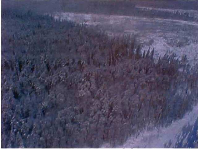
View of northern tip of the site. Rib Lake is at the bottom right and the harvested area is not in the conservation reserve. Photo taken by Erica Coulson December, 2000.
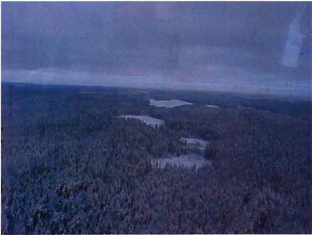
View of the unnamed lake within the site. Photo taken by Erica Coulson December 2000.
View of Rib Lake. The shore in the foreground is within the conservation reserve. Photo taken by Jennifer Telford July, 2003.
View of Rib Lake. Shore on the right is within the conservation reserve. Photo taken by Jennifer Telford July, 2003.
Appendix A: Dunmore Township Balsam Fir Outwash Deposit C1634 locator map
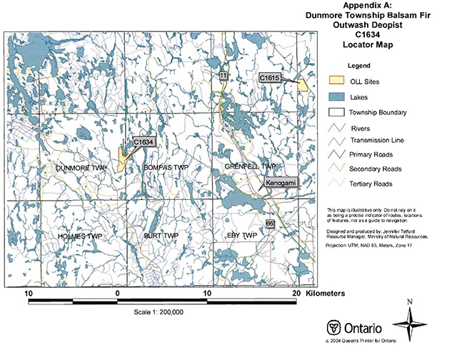
Enlarge Dunmore Township Balsam Fir Outwash Deposit C1634 locator map
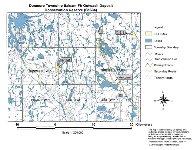
Appendix B: Map of Ontario’s Living Legacy sites in the area of C1634
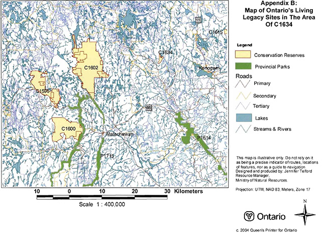
Enlarge Map of Ontario’s Living Legacy sites in the area of C1634
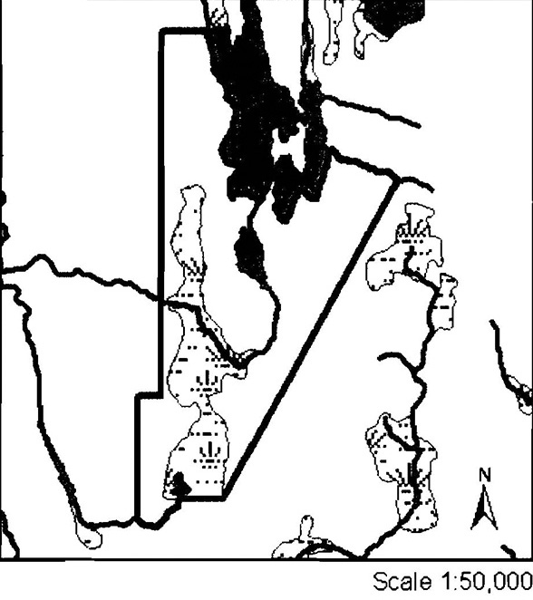
Appendix C: Wildlife management area’s in C1634
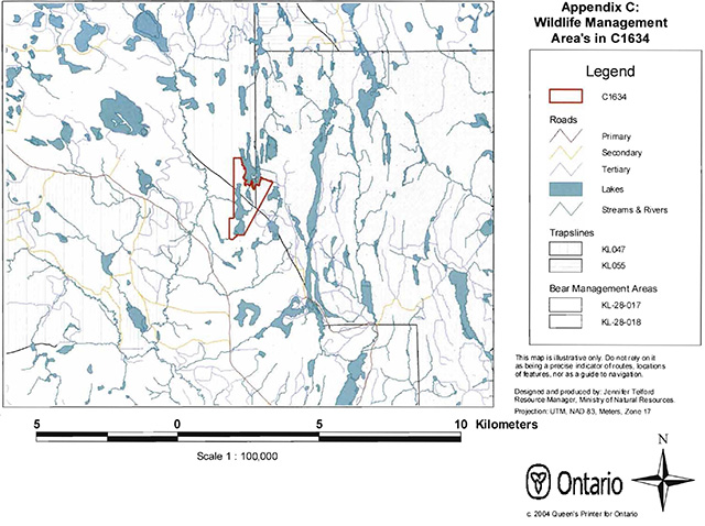
Enlarge Wildlife management areas in C1634 map
Appendix D: Dunmore Township Balsam Fir Outwash Deposit Conservation Reserve C1634 site access map
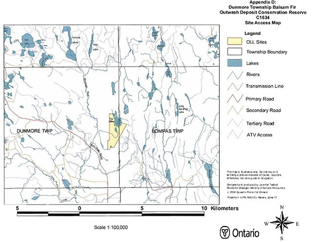
Enlarge Dunmore Township Balsam Fir Outwash Deposit Conservation Reserve C1634 site access map
Appendix 4: Procedural guideline B
Land uses - Test of Compatibility (PL Procedure 3.03.05)
The Conservation Reserve policy provides broad direction with regard to the permitted uses. The policy provides only an indication of the variety of uses that will be considered acceptable in Conservation Reserves. The only caution is that “any new uses, and commercial activities associated with them, will be considered on a case by case basis and, they must pass a test of compatibility to be acceptable.”
What does a “test of compatibility” mean? An examination of this must start from the premise of why an area is set aside-specifically, its representative natural heritage values. Criteria are then identified to guide compatibility considerations. These criteria apply to the long-term acceptability of both existing uses and new uses.
-
Conformity to SCI/RMP: SCI describes values for which an area has been set aside and the range of appropriate uses that will be permitted in the area. SCI may also speak to the acceptability of other ’new’ uses currently not occurring in the area.
The first ’test’ is: “do proposed new land uses and/or commercial activities conform to the direction of the SCI/RMP for the Conservation Reserve? Would the new use(s) depart from the spirit of appropriate indicator land uses in the SCI/RMP?”
- Impact assessment: If the proposed use(s) pass test 1 it is important to determine their impact on the area before they are approved. This should include the following:
- Impact on natural heritage values: "will the new use(s) impact any natural values in the area? If so, how and to what degree? Is it tolerable?
- Impact on cultural values: "will the new use(s) impact any historical or archaeological values in the area?
- Impact on research activities: “will the new use(s) affect research activities in the area?”
- Impact on current uses: “will the new use(s) have any negative impact on the array of current uses?”
- Impact on area administration: “will the new use(s) increase administrative cost and/or complexity?” (For example, the cost of area monitoring, security or enforcement).
- Impact on accommodating the use outside the Conservation Reserve: “Could the use(s) be accommodated as well or better outside the Conservation Reserve?”
- Impact on socio-economics of the area: “will the new use(s) affect the community (ies) surrounding the area in a positive or negative way?” (For example, will the new use make an area less remote thereby affecting a local tourism industry that is dependent on the area’s remoteness for its appeal?).
- Impact on area accessibility: “does the new use(s) give someone exclusive rights to the area or a portion of the area to the exclusion of other existing uses?”
Appendix 5: Procedural guideline C
Research activities in conservation reserves
Purpose
To encourage contributions to the goal of conservation reserves by:
- Providing direction for research activities associated with conservation reserves: and
- Establishing a process for the review and approval of proposals by researchers, which could have an impact on the values protected by the conservation reserve.
Definition
Research means any investigation or study of the natural, cultural, social, economic, management or other features of characteristics of conservation reserves.
Guidelines
Research will be encouraged to provide a better understanding of the natural values protected by a conservation reserve and to advance their protection, planning and management. The Statement of Conservation Interest will define, for each conservation reserve, the key research issues, set out the parameters within which research may occur and identify research needs.
Applications and approvals
Researchers must apply in writing to the Area Supervisor for permission to conduct research. The request letter must contain a statement explaining why the proposed research should be undertaken in the particular conservation reserve in preference to another location.
Proposals will be reviewed and approved by the Area Supervisor, guided by the Statement of Conservation Interest prepared for each reserve (See Guideline A Resource Management Planning) and using Guideline 8- Land Uses-Test of Compatibility. Permission must be granted in writing, including any conditions to be met in conducting the research, prior to the undertaking of any research project.
Terms and conditions
Permission to conduct research under this policy will be valid for a period of 12 consecutive months from date of issue. Permission to continue a research project for additional periods of 12 months or less may be granted upon submission of a written request and progress report. The Ministry may require the posting of collateral to assure that the terms and conditions of granting permission are to be met.
The Area Supervisor may suspend or revoke permission at any time for failure on the part of the researcher to meet:
- The intent or conditions of this policy.
- The requirements under the Public Lands Act, including all amendments, where applicable.
- The requirements under any other Act or Regulations or Ontario or Canada, including those governing the taking, handling, storing, confining, trapping, excavating and marketing any specimen, artifact, information or action (for example, scientific collector’s permit).
- The conditions and agreements specified in granting permission.
Final report
The researcher will submit copies of reports, publications and theses following from the results of the project to the Area Supervisor.
Appendix 6: Crown Land Use Atlas
Crown Land Use Policy Atlas - Policy report
C1634
Dunmore Township Balsam Fir Outwash Plain
Updated: January 16, 2004
Identification:
ID: C1634
Area Name: Dunmore Township Balsam Fir Outwash Plain
Area (ha): 203
Designation: Conservation Reserve (Ontario’s Living Legacy)
MNR District(s): Kirkland Lake
Description:
This site contains some balsam fir, open and treed muskeg and older birch on moderately broken outwash deposits.
Dunmore Township Balsam Fir Outwash Plain was regulated as a conservation reserve on April 6, 2001.
Land use intent:
Management of this area is also governed by the general policies contained in the Land Use Strategy (1999).
Management direction:
Those uses and management activities not listed in the following table are governed by existing conservation reserve policy. Over time the management direction will be elaborated in a Statement of Conservation Interest or Resource Management Plan. Any new uses, and commercial activities associated with conservation reserves, will be considered on a case by case basis, and they must pass a test of compatibility to be acceptable. Compatibility is normally determined through a planning process.
Commercial activities
| Activity | Permitted | Guidelines |
|---|---|---|
| Aggregate extraction | No | |
| Bait fishing: existing | Yes | Existing use permitted to continue, unless there are significant demonstrated conflicts. |
| Bait fishing: new | Maybe | New operations can be considered, subject to the “test of compatibility”. |
| Commercial fishing: existing | Yes | Existing use permitted to continue, unless there are significant demonstrated conflicts. |
| Commercial fishing: new | Maybe | New operations can be considered, subject to the “test of compatibility”. |
| Commercial fur harvesting: existing | Yes | Existing use permitted to continue, unless there are significant demonstrated conflicts. Existing trap cabins can continue; new cabins are not permitted. |
| Commercial fur harvesting: new | Maybe | New operations can be considered, subject to the “test of compatibility”. |
| Commercial hydro development | No | |
| Commercial timber harvest | No | |
| Commercial tourism: existing | Yes | Existing authorized facilities can continue, unless there are significant demonstrated conflicts. |
| Commercial tourism: new | Maybe | New tourism facilities can be considered during the planning for an individual reserve. |
| Bear hunting by non-residents (guided): existing | Yes | Existing authorized operations permitted to continue. |
| Bear hunting by non-residents (guided): new | No | New operations not permitted. |
| Outfitting services: existing | Yes | Existing authorized operations permitted to continue. |
| Outfitting services: new | Maybe | New operations can be considered during the planning for an individual reserve. |
| Outpost camps: existing | Yes | Existing authorized operations permitted to continue. |
| Outpost camps: new | Maybe | New operations can be considered during the planning for an individual reserve. |
| Resorts/lodges: existing | Yes | Existing authorized facilities permitted to continue. |
| Resorts/lodges: new | Maybe | New facilities can be considered during the planning for an individual reserve. |
| Energy transmission and communications corridors: existing | Yes | These facilities should avoid conservation reserve lands wherever possible. |
| Energy transmission and communications corridors: new | No | These facilities should avoid conservation reserve lands wherever possible. |
| Food harvesting (commercial): existing | Maybe | |
| Food harvesting (commercial): new | Maybe | |
| Mineral exploration and development | No | |
| Peat extraction | No | |
| Wild rice harvesting: existing | Yes | |
| Wild rice harvesting: new | Maybe |
Land and resource management activities
| Activity | Permitted | Guidelines |
|---|---|---|
| Crown land disposition private use: | Maybe | Sale of lands is not permitted, except for minor dispositions in support of existing uses (e.g. reconstruction of a septic system). Renewals of existing leases and land use permits are permitted. Requests for transfer of tenure will be considered in the context of the Statement of Conservation Interest or Resource Management Plan. New leases or land use permits permitted for approved activities. Tourism facilities can apply to upgrade tenure from LUP to lease. |
| Crown land disposition commercial use: | Maybe | Sale of lands is not permitted, except for minor dispositions in support of existing uses (e.g. reconstruction of a septic system). Renewals of existing leases and land use permits are permitted. Requests for transfer of tenure will be considered in the context of the Statement of Conservation Interest or Resource Management Plan. New leases or land use permits permitted for approved activities. Tourism facilities can apply to upgrade tenure from LUP to lease. |
| Fire suppression | Yes | Fire suppression policies are similar to adjacent Crown lands, unless alternative fire policies have been developed through a planning process. |
| Fish habitat management | Maybe | Conservation Reserves policy indicates that “featured species management” may be permitted. |
| Insect/disease suppression | Maybe | |
| Inventory/monitoring | Yes | |
| Prescribed burning | Maybe | |
| Roads (resource access) existing: | Yes | Existing roads can continue to be used. Continued use will include maintenance and may include future upgrading. |
| Roads (resource access) new: | Maybe | New roads for resource extraction will not be permitted, with the exception of necessary access to existing forest reserves for mineral exploration and development. |
| Vegetation management | Maybe | Conservation Reserves policy indicates that Featured Species Management and Natural Systems Management may be permitted. Vegetation management can be considered in a planning process. |
| Wildlife population management | Maybe |
Science, education and heritage appreciation
| Activity | Permitted | Guidelines |
|---|---|---|
| Collecting | No | |
| Historical appreciation | Yes | |
| Nature appreciation | Yes | |
| Photography and painting | Yes | |
| Research | Yes | |
| Wildlife viewing | Yes |
Recreation activities and facilities
| Activity | Permitted | Guidelines |
|---|---|---|
| All terrain vehicle use on trails | Yes | Existing use permitted to continue where it does not adversely affect the values being protected. |
| All terrain vehicle use off trails | No | ATVs use off trails is not permitted, except for direct retrieval of game. |
| Campgrounds | Maybe | |
| Food gathering | Yes | |
| Horseback riding (trail) | Yes | Existing use on trails permitted. |
| Hunting | Yes | |
| Mountain bike use | Yes | Existing use on trails permitted. |
| Motor boat use commercial | Yes | |
| Motor boat use private | Yes | |
| Non-motorized recreation travel | Yes | |
| Private recreation camps (hunt camps): existing | Yes | Existing camps permitted to continue, and may be eligible for enhanced tenure, but not purchase of land. |
| Private recreation camps (hunt camps): new | No | Existing camps permitted to continue, and may be eligible for enhanced tenure, but not purchase of land. |
| Rock climbing | Maybe | |
| Snowmobiling on trails | Yes | Except for the direct retrieval of game. |
| Snowmobiling off trails | No | |
| Sport fishing | Yes | |
| Trail development: existing | Yes | Development of trails for a variety of activities (e.g., hiking, cross-country skiing, cycling, horseback riding, snowmobiling) can be considered as part of planning for an individual reserve. |
| Trail development: new | Maybe | Development of trails for a variety of activities (e.g., hiking, cross-country skiing, cycling, horseback riding, snowmobiling) can be considered as part of planning for an individual reserve. |
Note: The policies outlined in this table do not supersede any Aboriginal or treaty rights that may exist, or other legal obligations.
Management of this conservation reserve is carried out within the context of Conservation Reserve policy as amended by the policies for new conservation reserves outlined in the Ontario’s Living Legacy Land Use Strategy.
Source of direction:
Ontario’s Living Legacy Land Use Strategy (1999)
Conservation Reserves Policy (1997)
Explanation of edits:
Area Name has been edited.
Appendix 7: Locator map
Dunmore Township Balsam Fir Outwash Deposit Conservation Reserve (C1634)
Enlarge Dunmore Township Balsam Fir Outwash Deposit Conservation Reserve (C1634) map
Appendix 8: Natural heritage - life science checksheet
Name
C1634 - Dunmore Township Balsam Fir Outwash Deposit
Map Name
Kirkland Lake
Map Number
42-A-01
UTM Ref.
544533
Locality
Timiskaming
Lat.
49°05’02"N
Long.
81°42’46"W
NAD
83 CNT
Min. Alt.
340m
Max. Alt.
360m
Township·
Dunmore, Bompas
Area
203 ha
Ownership
Crown
MNR Region
Northeast
MNR District
Kirkland Lake
Ecoregion and Ecodistrict
3E-6 (Hills, 1959; Grins, 2000)
Landform Unit(s)
9- Organic Deposits
3b,2a - Till Deposits with Bedrock-Drift Complex
2ac- Bedrock-Drift Complex
Aerial Photographs
Year - Roll - Flight Line - Numbers
1986 - 02 - 4805 - 110 and 111
1986-02-4806- 168 and 169
C1634 Dunmore Township Balsam Fir Outwash Deposit CR
Physical and biological features
Representation
The Dunmore Township Balsam Fir Outwash Deposit Conservation Reserve is located approximately 30 km west of Kirkland Lake in Dunmore and Bompas townships. This site consists largely of vectored boundaries with the exception of a biological boundary in the northern part of the site along Rib Lake and a biological boundary along a small unnamed creek in the southern part of the site. Access to the outer limits of the site may be available via an old logging road that has most likely grown over since the road was shown on an aerial photo taken in 1986. The only available access to the interior of the site is by air. The original gap analysis for this site describes the site as having balsam fir, open and treed muskeg and older birch on moderately broken outwash deposits at a size of 125 ha (Ritchie and Thompson 1998).
This conservation reserve is the westernmost site in the Kirkland Lake 3E-6 Ecodistrict. Ecodistrict 3E-6 is found within the Lake Abitibi Ecoregion, which is characterized by moderately to gently rolling bedrock, generally covered by deep deposits of clay, silt and sand. The Kirkland Lake Ecodistrict is found to contain moderate plains of granitic and low base bedrock generally thinly covered with granitic and low-base sand and silty sand. The forest climate type for Lake Abitibi Site Region is mid-humid, mid-boreal (Hills, 1959; Poser, 1992).
The Dunmore Township Balsam Fir Outwash Deposit Conservation Reserve is found within the Abitibi upland physiographic region. This region contains broad rolling surfaces that reach about 1500 feet near its southern borders and is underlain by crystalline Archean rocks (Bostock, 1970). The provincial landform coverage shows this site to be dominated by moderately broken outwash deposit with a small area of lacustrine deposit located in the southern part of the site (Map 1b). Kristjansson offered a preliminary landform analysis, which shows a large portion of the site to contain bedrock-drift complex with smaller areas of till deposits with subordinate areas of bedrock-drift complex located south of the unnamed lake in the center of the site. There are also a number of organic deposits, which are associated with the wetland areas and the unnamed lake.
The Dunmore Township Balsam Fir Outwash Deposit Conservation Reserve is found within the Missinaibi-Cabonga Section of Rowe’s (1972) Boreal Forest Region. The Missinaibi-Cabonga Section contains mixed forests of balsam fir, black spruce and white birch with scattered white spruce and trembling aspen. The presence of eastern white and red pine can be found on rocky shores and ridges but only to a small degree due to past logging practices. Jack pine is situated along rivers and found in association with black spruce on poor rocky soils. Black spruce are also found in combination with tamarack and white cedar in wet lowland areas (Rowe, 1972).
The Forest Communities Map 2a shows this site to be largely made up of black spruce predominant conifer
The stocking for this site is almost equally split between stands stocked between 61-80 percent and 81-99 percent with the exception of a small stand stocked at 100 percent and one at 41-60 percent (Map 2b). The majority of the stands within this site are aged between 30-59 and 60-89 years. There is a stand aged between 90-119 years in the northwest corner of the site, which is the site’s old growth community (Map 2c).
There is a good diversity of wetlands
The Dunmore Township Balsam Fir Outwash Conservation Reserve falls within the Ottawa River Basin in tertiary watershed 2JC. The site borders Rib Lake and contains two small unnamed lakes and Rib Creek. Wildlife values for this site include two traplines (KL047) (KL055), two bear management areas (KL-28-017) (KL-28-018) and a moose wintering area (Map 3a).
Condition
Disturbance on the inside of the site was rated low with only two small harvested pure jack pine stands located along the eastern boundary of the conservation reserve. However, there was significant harvest activity in areas surrounding the site. There were two hunters blinds observed during the aerial reconnaissance survey located at (543520E, 5331919W) and (543757E, 5331698 W). Dead trees were spotted in the western part of the site during the reconnaissance survey, which suggests the possibility of beaver activity.
Diversity
Diversity is a measure of the site’s life and earth science heterogeneity
Upon review of the forest communities map (Map 2a) and the FRI data it is apparent that approximately half of the vegetative communities within the site are fractured from the presence of vectored boundaries and are less then 10 ha in size. These communities do not significantly contribute to the overall diversity of the site. The diversity for this site was evaluated using the five most dominant vegetative communities, which are relatively equally represented within the conservation reserve giving a somewhat even distribution of communities. However, diversity for this site is rated low considering the lack of core forest communities and the fragmentation of existing core forest communities, the lack of forest communities providing a buffer to protect core values and the overall small size of the site.
The FRI data was further grouped using Standard Forest Units (SFUs) to provide more of an ecological depiction of the site’s forest communities. This analysis resulted in five SFUs however the PJ1 SFU should not be included in the landform: vegetation analysis since these areas have been harvested. If we compare the four SFUs (PJ1 excluded) with Kristjansson’s landforms interpretation we see that there would be approximately 7 landform: vegetation combinations, however this is just a rough estimate and a landform: vegetation analysis for this site is still required. When considering the 7 potential landform: vegetation combinations the diversity of the site is considered low. Diversity would have been slightly increased if developmental stages were considered in the grouping of FRI into SFUs. If developmental stages are included in the grouping of FRI into SFUs the number of SFUs would increase from 4 to 7 and would subsequently increase the number of landform: vegetation combinations.
Overall diversity for this conservation reserve is considered to be low given the low number of potential landform: vegetation combinations, the fragmentation of core forest communities, the significant number of vectored boundaries and the small size of the site. Diversity is expected to increase slightly once a landform: vegetation analysis is completed using SFUs, Kristjansson’s landforms, developmental stages and wetland communities.
Ecological considerations
Wherever possible, a site’s boundaries should be created to include the greatest diversity of life and earth science features to provide the maximum ecological integrity. It should be ecologically self-contained, bounded by natural features and include adequate areas to buffer the core ecosystems from adjacent land use activities (OMNR, 1992). A large portion of this conservation reserve is contained by vectored boundaries, which dominate the east, west and the majority of the southern parts of the site. Biological boundaries do exist in the northern and southern parts of the site. The northern boundary follows the south to west shoreline of Rib Lake and the site’s southern boundary follows an unnamed creek. Due to the strong presence of vectored boundaries many of the sites major forest communities are fragmented which diminishes the sites ability to protect core values. Furthermore, the few forest communities that offer a buffer for the site’s interior core communities have either been harvested or are too small in size thus reducing the protective capacity of the site even further. The presence of vectored boundaries may also result in greater number of tress passes from adjacent land use activities which could negatively affect the site’s core values.
Currently we do not have minimum size standards for conservation reserves under different landscape conditions. However, a minimum size standard of 2000 ha has been established for natural environment parks by Ontario Parks (OMNR, 1992). This minimum standard was considered necessary to protect representative landscapes as well as allow for low intensity recreational activities. The Dunmore Township Balsam Fir Outwash Deposit Conservation Reserve is 203 ha in size and therefore falls short of meeting the 2000 ha minimum standard. The size of the site and lack of major waterways and trails limit the recreational potential for this conservation reserve. Furthermore, the combination of the site’s small size and the strong presence of vectored boundaries inhibit the site’s ability to protect core values.
Special features
Special features for this site include the shoreline of Rib Lake, which acts as the site’s northern boundary. Secondly, the peninsula of mixed forest in the center of the site surrounded by wetland complexes and leading into the large semi treed bog wetland complex is an interesting arrangement of vegetative communities.
Major information sources
Arnup, R., G.D. Racey and R.E. Whaley. 1999. Training manual for photo interpretation of ecosites in northwestern Ontario. NWST Technical Manual TM-003. 127 p.
Bostock, H.S. 1970. Geology and economic minerals of Canada- Part A
Bridge, S., R. Watt, G. Lucking and B. Naylor. 2000. Landscape analysis for forest management planning in boreal northeastern Ontario. OMNR, Northeast Science and Technology. 36 p.
Grins, W.J. 2000. Ecoregions of Ontario: modifications to Angus Hills’ Site Regions and Site Districts revisions and rationale.
Hills, G.A. 1959. A steady reference to the description of the land of Ontario and its productivity.
Kristjansson, R. 2002. Dunmore Township Balsam Fir Outwash Deposit Conservation Reserve Earth Science Checksheet. Draft MNR report. 2 p.
Ontario Ministry of Natural Resources. 1992. Ontario Provincial Parks: Planning and Management Policies, 1992 Update.
Ontario Ministry of Natural Resources. 1999. Ontario’s Living Legacy Land Use Strategy, Queens Printer for Ontario, Toronto, ON. 136 p.
Ontario Ministry of Natural Resources. 2002. MNR districts and major basins of Ontario.
Poser, S. 1992. Report on the Status of Provincial Parks in the Site Regions and Districts of Ontario.
Rowe, J.S. 1972. Forest regions of Canada. Dept. of Fisheries and the Environment. Canadian Forestry Service. Publ. No. 1300. 172 pp.
Taylor, K.C., R.W. Arnup, B.G. Merchant, W.J. Parton and J. Nieppola. 2000. A field guide to forest ecosystems of northeastern Ontario. 2nd Edition. Northeast Science and Technology NEST Field Guide FG-001.
Thompson, J. 2002. Aerial Reconnaissance Surveys for Dunmore Township Balsam Fir Outwash Deposit Conservation Reserve. September 16, 2002.
Uhlig, P., A. Harris, G. Craig, C. Bowling, B. Chambers, B. Naylor and G. Beemer. 2001. Old growth forest definitions for Ontario. Ont. Ministry of Natural Resources, Queen’s Printer for Ontario, Toronto. ON. 27 p.
Significance level (Provincial/Regional/Local) and brief summary of major representative values
Since this site’s configuration has changed and it has increased in size its significance for life science representation and contribution to the parks and protected areas system is currently unknown. However, the original gap analysis captured this site for its wetlands, balsam fir and birch communities which are still included in the site’s new configuration and therefore may still be significant (Appendix 1, History Map). Any future gap analysis for Ecodistrict 3E-6 must consider this conservation reserve. The rather low diversity and small size could limit the site’s ability to contribute significantly to the parks and protected areas system.
Sensitivity
The most sensitive features of this site are the wetland communities, which are sensitive to recreational activities and resource development depending on the season and the type of activity.
Recommendations
- This second step checksheet should be advanced to a fourth step by digitizing the earth science data based on Kristjansson’s interpretations and used with SFUs and developmental stage information to complete a current landform: vegetation analysis. In addition, photos and sampling areas should be mapped and added to the checksheet. Finally, the checksheet could be advanced to a fifth step by comparing the fourth step checksheet with the current provincial landform layers based on the new regulated boundary. This would show the comparisons that can be made between the above local analysis and the provincially run analysis and would determine more fully the site’s significance and contribution to the parks and protected areas program.
- The vectored defined boundaries for the site should be marked and biological boundaries more clearly defined to ensure that the values within the site are protected from surrounding land use activities. Further analysis and assessment may require additional management prescription to ensure long-term protection of the site’s natural heritage values.
- Funding should be secured in the near future to determine the number and location of any trails currently present within the site using current global positioning technologies. Location of trails as well as current condition and potential problems or required rehabilitation should be part of any future trail analysis.
- Areas of the site that are regenerating poorly may need to be reviewed by silvicultural and natural heritage specialists to determine if additional management action is required. The impact of the various trails in these areas on the regeneration process may need to be looked at.
- Any future economic or development proposals should go through a Test of Compatibility to ensure the natural heritage features are well protected. For example, any future trail development must consider the values found within the boundaries of the site, the rationale for developing trails within the site and the availability of current access through the site and surrounding areas. Furthermore, any new trail development will require a ’Test of Compatibility’. Sensitive areas previously discussed should be avoided.
- Future additions to the parks and protected areas system should consider improving the design of the site to enhance core features. Additions to this conservation reserve should only occur if a vegetative rehabilitation plan is funded in the near future.
- Overall custodial management is the responsibility of the district office with support from the regional natural heritage specialist and Ontario Parks. To advance conservation reserve custodial management, future managers will need to monitor the current state of the CR’s resources at least at the community and landscape levels within and adjacent to the conservation reserve and its surrounding environment. Such monitoring could include: evaluating and reporting on changes such as; natural disturbances (i.e. fire, insect/disease, wind throw, etc.), human disturbances (i.e. forest harvesting, access and/or other land use activities) as well as management prescriptions (i.e. rehabilitation efforts and/or vegetative management planning).
- Ongoing evaluations and reports will have to rely on current and new technologies such as satellite imagery, global positioning systems (GPS), supplementary aerial photography (SAP) and/or aerial/ground reconnaissance surveys/assessments conducted periodically and placed within a GIS database. Such tools could help managers spatially record areas affected, severity of perturbations or management action as well as consider the sensitivity of values, the design of CR and determine the future desired condition of the site. Monitoring efficiencies could be enhanced via partnerships and internal coordination within MNR
footnote 5 .
Time Effort Spent on Site
September 16, 2002 10:12 am to 11:50 am
Date Compiled
May 28, 2003
Compiler(s)
Jake Noordhof, John Thompson, Lori King and Sean Longyear.
Date Reviewed
Reviewer
C1634 Dunmore Township Balsam Fir Outwash Deposit CR map 1a
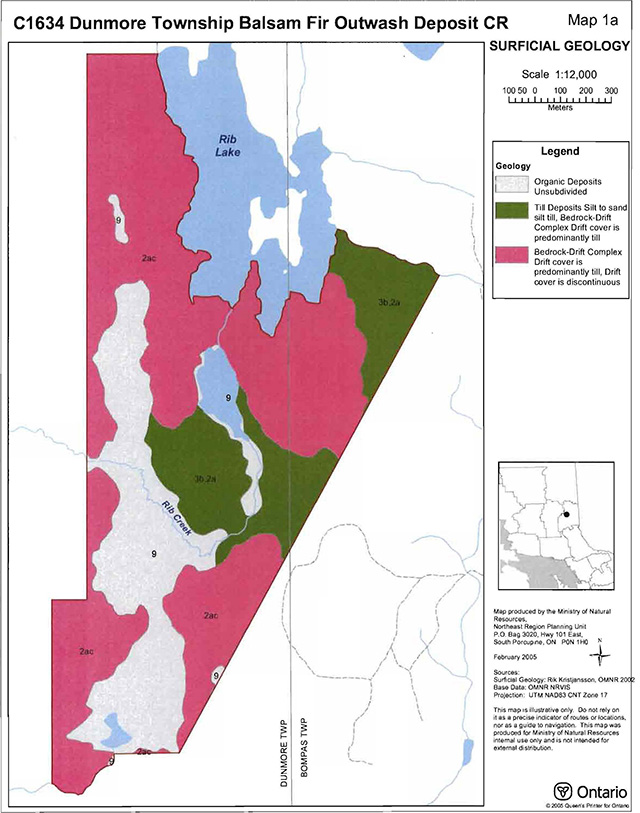
Enlarge C1634 Dunmore Township Balsam Fir Outwash Deposit Conservation Reserve map 1a
C1634 Dunmore Township Balsam Fir Outwash Deposit CR map 1b
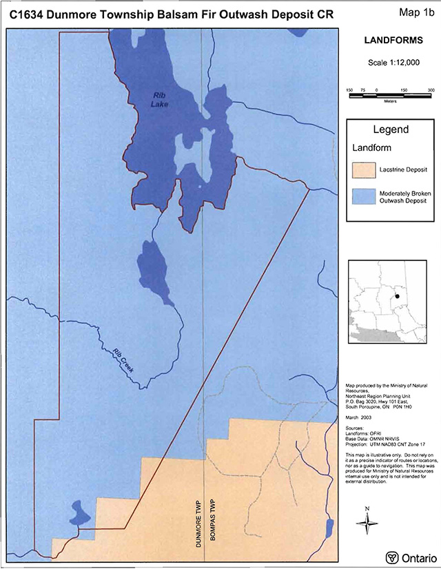
Enlarge C1634 Dunmore Township Balsam Fir Outwash Deposit Conservation Reserve map 1b
C1634 Dunmore Township Balsam Fir Outwash Deposit CR map 2a
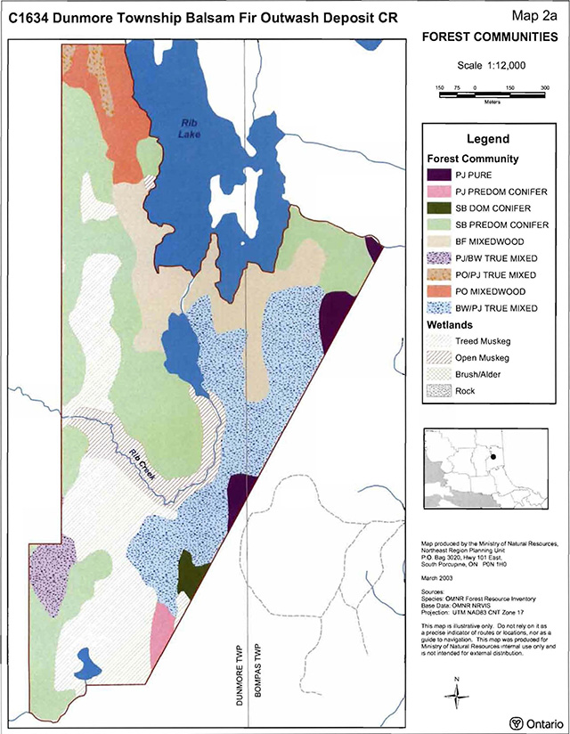
Enlarge C1634 Dunmore Township Balsam Fir Outwash Deposit Conservation Reserve map 2a
C1634 Dunmore Township Balsam Fir Outwash Deposit CR map 2b
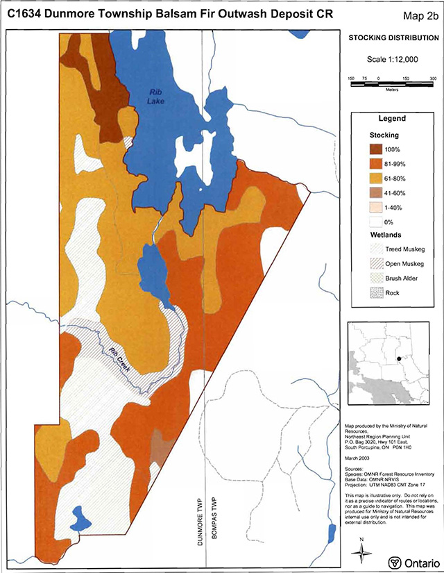
Enlarge C1634 Dunmore Township Balsam Fir Outwash Deposit Conservation Reserve map 2b
C1634 Dunmore Township Balsam Fir Outwash Deposit CR map 2c
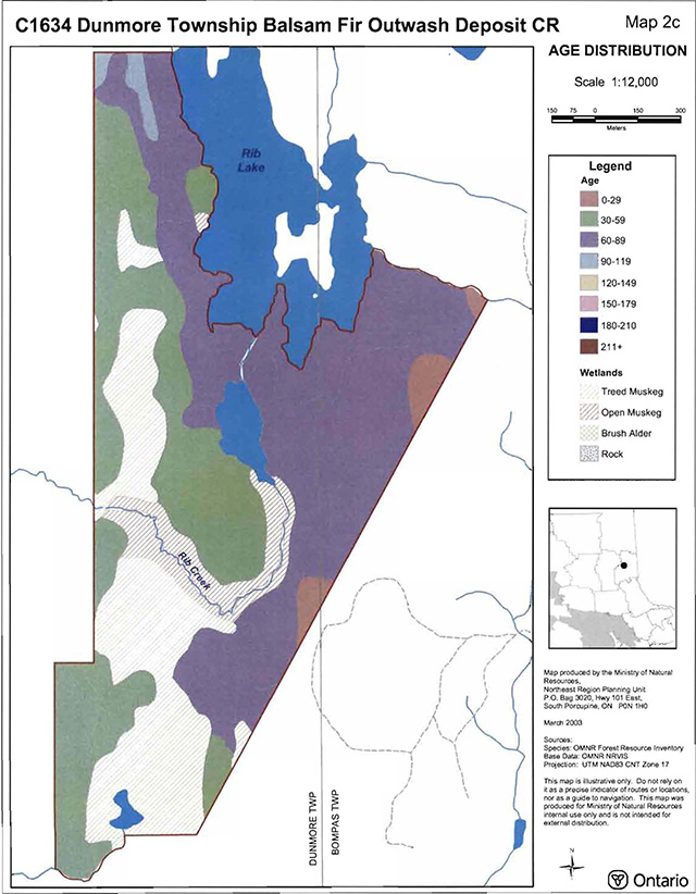
Enlarge C1634 Dunmore Township Balsam Fir Outwash Deposit Conservation Reserve map 2c
C1634 Dunmore Township Balsam Fir Outwash Deposit CR map 2d
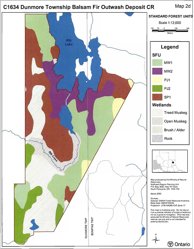
Enlarge C1634 Dunmore Township Balsam Fir Outwash Deposit Conservation Reserve map 2d
C1634 Dunmore Township Balsam Fir Outwash Deposit CR map 3a
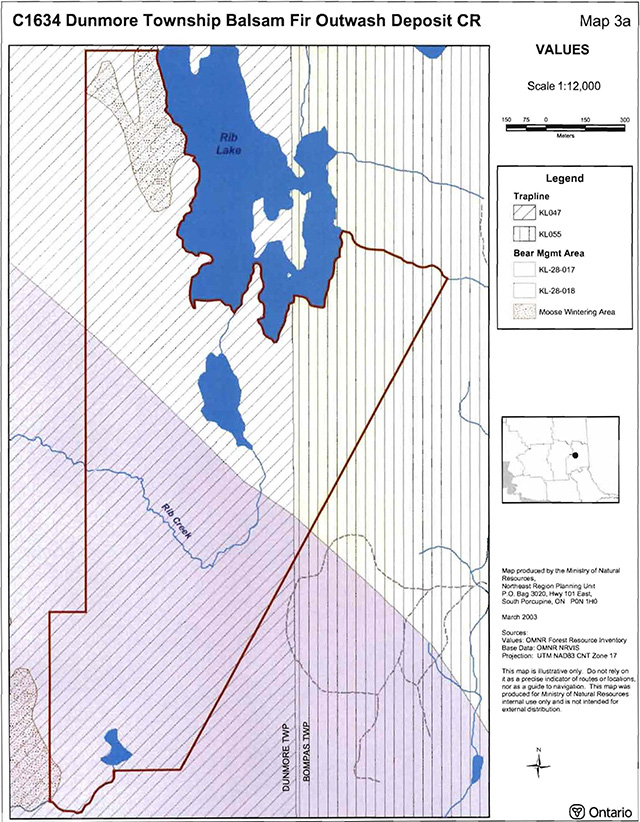
Enlarge C1634 Dunmore Township Balsam Fir Outwash Deposit Conservation Reserve map 3a
C1634 Dunmore Township Balsam Fir Outwash Deposit CR map 3b
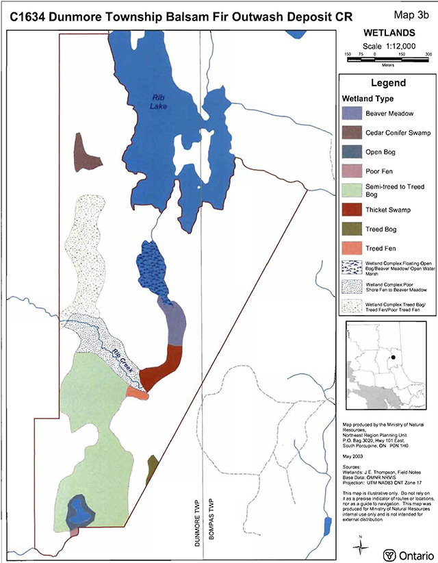
Enlarge C1634 Dunmore Township Balsam Fir Outwash Deposit Conservation Reserve map 3b
C1634 Dunmore Township Balsam Fir Outwash Deposit CR map 5
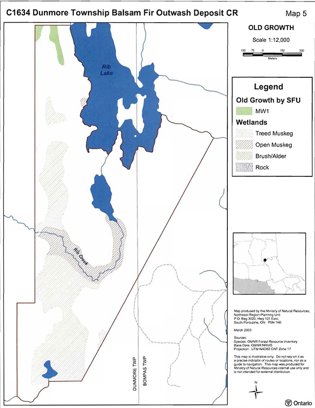
Enlarge C1634 Dunmore Township Balsam Fir Outwash Deposit Conservation Reserve map 5
Appendix 9: Earth science checksheet
Dunmore Township Conservation Reserve (C1634) approved earth science checksheet
Kirkland Lake
February 8, 2005
Prepared by: F.J. (Rik) Kristjansson
Earth science inventory checklist
Name:
Dunmore Township Balsam Fir (C1634)
Map Name:
Kirkland Lake
NTS Number:
42 A/01
UTM Ref. (Datum):
544533
Latitude:
48° 08’ 34" N
Longitude:
80° 24’ 37" w
Elevation (Min):
340m asl
Elevation (Max):
360m asl
Locality:
Timiskaming
Township:
Dunmore, and Bompas
Area (ha):
203 ha
MNR District:
Kirkland Lake
MNR Region:
Northeast
Aerial Photographs:
86-02, 4806, 110 and 111
86-02, 4805, 168 and 169
Prepared by:
F.J. (Rik) Kristjansson, Consulting Geoscientist
Reviewed by:
Phil Kor, Senior Conservation Geologist
Date:
February 8, 2005
Earth science features
Bedrock geology:
Based on Map 2543 (Ontario Geological Survey, 1991), the Dunmore Township Balsam Fir Conservation Reserve is entirely underlain by undifferentiated igneous intrusive rocks of the Abitibi Subprovince, Superior Province, Precambrian Shield. A compound map unit designation (in this case, Unit 15, 14) is used to classify the area containing the conservation reserve. Unit 15 is described as “massive to foliated granodiorite to granite”, and Unit 14 is described as a “Diorite-monzonite granodiorite suite” (Ibid.).
Surficial geology:
Based on a brief helicopter reconnaissance survey, review of terrain geological mapping (Lee, 1979, Data Base Map 5030), review of surficial geological mapping (Baker, 1980, Map P.2382), and interpretation of available aerial photography, the Dunmore Township Balsam Fir Conservation Reserve is immediately underlain by areas of Bedrock-Drift Complex (Unit 2ac), Till Deposits (with subordinate areas of Bedrock-Drift Complex; Unit 3b,2a), and Organic Deposits (Unit 9). Please refer to the attached preliminary surficial geological mapping for the occurrence and distribution of these surficial geological units within the conservation reserve (Appendix A).
Three areas of Bedrock-Drift Complex (Unit 2ac) are present within the conservation reserve. A relatively extensive area of bedrock-drift complex is located in the north half of the conservation reserve. This northern area of bedrock-drift complex dominates the surficial geology of the north half of the conservation reserve. In addition, two moderately extensive areas of bedrock-drift complex are situated in the southeast and southwest parts of the conservation reserve. With reference to the morphology of the bedrock surface, bedrock ridge forms are predominant with respect to the north and southeast areas of bedrock-drift complex. In contrast, bedrock knob (or knoll) forms are predominant in relation to the southwest area of bedrock-drift complex. Moderate bedrock exposure associated with a discontinuous cover of till is anticipated within these areas of bedrock-drift complex.
Two moderately extensive areas of Till Deposits (Unit 3b, 2a) are located in the central to central east part of the conservation reserve, and in the northeast part. As indicated by the compound surficial geological map unit designation, subordinate, but difficult to delineate, areas immediately underlain by bedrock-drift complex (i.e., bedrock-till complex) might also be present within these moderately extensive areas of till deposits. During the helicopter reconnaissance survey, a brief landing was made to examine in greater detail the surficial geology of the conservation reserve. A shovel test pit was excavated within the area of till deposits, which immediately underlies the central to central east part of the conservation reserve. At the test pit location, a gravelly, silt (to sandy silt) till was observed. The gravel component included granules, pebbles, cobbles, and small boulders. In the general area of the shovel test pit, occasional small boulders were observed at the ground surface.
Finally, in addition to several minor areas of Organic Deposits (Unit 9), a relatively extensive area of organic deposits located in the northwest, southwest, and southeast parts of the conservation reserve is noteworthy (Photo. C1634-01).
Significance:
The geological features described above are commonly encountered throughout this region, and are considered to be of only local significance.
Sensitivity:
Considering the relatively passive land uses anticipated within a conservation reserve (e.g., hunting), the various surficial geological units (with the exception of the areas of organic deposits) are considered to have low sensitivity. The areas of organic deposits (i.e., peatlands) may be sensitive to ATVs (i.e., “all-terrain vehicle”) traffic.
Recommendations:
None
References:
Baker, C.L., 1980; Quaternary Geology of the Kirkland Lake Area, District of Timiskaming; Ontario Geological Survey, Map P.2382, Geological Series, Preliminary Map, Scale 1:50,000. Geology 1978 and 1979.
Lee, H.A., 1979; Northern Ontario Engineering Geology Terrain Study, Data Base Map, Kirkland Lake; Ontario Geological Survey, Map 5030, Scale 1:100,000.
Ontario Geological Survey, 1991; Bedrock Geology of Ontario, East-Central Sheet; Ontario Geological Survey, Map 2543, Scale 1:1,000,000.
Appendices:
Appendix A Preliminary Surficial Geology of the Dunmore Township Balsam Fir Conservation Reserve (C1634).
Photographs:
Photo. C1634-0l
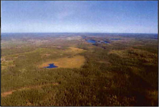
Provides a general view approximately north across the conservation reserve. The relatively extensive area of organic deposits, located in the northwest, southwest, and southeast parts of the conservation reserve, is evident in the central part of the photograph (the tan brown to very pale green area).
Appendix A
Preliminary Surficial Geology of the Dunmore Township Balsam Fir Conservation Reserve (C1634).
Appendix 10: Regulation map
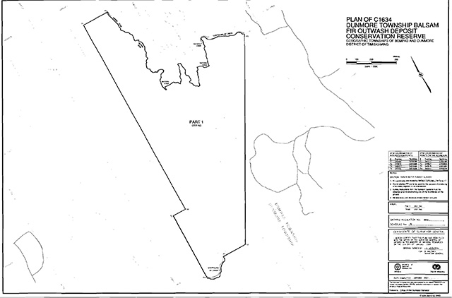
Footnotes
- footnote[1] Back to paragraph Conifer stands are defined as follows: pure conifer stands contain 100 percent conifer trees in the canopy, domiinant conifer stands contain less than 10 percent cover of hardwoods in the main canopy and predominant conifer stands contain less than 20 percent cover of hardwoods in the main canopy. Similarly, hardwood stands may contain no conifer in canopy (pure hardwood), less than 10 percent conifer (dominant hardwood) or less than 20 percent conifer cover (predominant hardwood) (modified after Taylor et al. 2000).
- footnote[2] Back to paragraph Mixedwoods are defined as follows: hardwood mixedwoods are stands dominated by hardwoods with less than 30 percent cover of conifer in the main canopy, similarly conifer mixedwoods contain less than 30 percent hardwoods in the canopy. Mixedwoods contain approximately equal percentages of conifer and hardwood trees and true mixedwoods contain a 50:50 split between conifers and hardwoods (modified after Taylor et al. 2000).
- footnote[3] Back to paragraph Wetlands were classified after Arnup et al. 1999
- footnote[4] Back to paragraph Age class includes pre-sapling, immature, mature and old (modified after Bridge et al. 2000).
- footnote[5] Back to paragraph Coordination could include a variety of expertise from the following: Field Services Division, Ontario Parks, Aviation and Forest Fire Management Branch, Forest Health and Silvicultural and Forest Management Planning Sections, Northeast Science and Information etc. Additional expertise within and outside the MNR could be sought as required.