Dwarf Hackberry Recovery Strategy
This document advises the ministry on ways to ensure healthy numbers of the Dwarf Hackberry, a threatened or endangered species, return to Ontario.
About the Ontario recovery strategy series
This series presents the collection of recovery strategies that are prepared or adopted as advice to the Province of Ontario on the recommended approach to recover species at risk. The Province ensures the preparation of recovery strategies to meet its commitments to recover species at risk under the Endangered Species Act (ESA) and the Accord for the Protection of Species at Risk in Canada.
What is recovery?
Recovery of species at risk is the process by which the decline of an endangered, threatened, or extirpated species is arrested or reversed, and threats are removed or reduced to improve the likelihood of a species' persistence in the wild.
What is a recovery strategy?
Under the ESA a recovery strategy provides the best available scientific knowledge on what is required to achieve recovery of a species. A recovery strategy outlines the habitat needs and the threats to the survival and recovery of the species. It also makes recommendations on the objectives for protection and recovery, the approaches to achieve those objectives, and the area that should be considered in the development of a habitat regulation. Sections 11 to 15 of the ESA outline the required content and timelines for developing recovery strategies published in this series.
Recovery strategies are required to be prepared for endangered and threatened species within one or two years respectively of the species being added to the Species at Risk in Ontario list. There is a transition period of five years (until June 30, 2013) to develop recovery strategies for those species listed as endangered or threatened in the schedules of the ESA. Recovery strategies are required to be prepared for extirpated species only if reintroduction is considered feasible.
What’s next?
Nine months after the completion of a recovery strategy a government response statement will be published which summarizes the actions that the Government of Ontario intends to take in response to the strategy. The implementation of recovery strategies depends on the continued cooperation and actions of government agencies, individuals, communities, land users, and conservationists.
For more information
To learn more about species at risk recovery in Ontario, please visit the Ministry of Natural Resources Species at Risk webpage at: www.ontario.ca/speciesatrisk
Recommended citation
Ontario Ministry of Natural Resources. 2013. Recovery Strategy for the Dwarf Hackberry (Celtis tenuifolia) in Ontario. Ontario Recovery Strategy Series. Ontario Ministry of Natural Resources, Peterborough, Ontario. iii + 5 pp + Appendix vi + 43 pp. Adoption of Recovery Strategy for Dwarf Hackberry (Celtis tenuifolia) in Canada (Parks Canada Agency 2011).
© Queen’s Printer for Ontario, 2013
ISBN 978-1-4606-0537-0 (PDF)
Content (excluding the cover illustration) may be used without permission, with appropriate credit to the source.
Cette publication hautement spécialisée Recovery strategies prepared under the Endangered Species Act, 2007, n'est disponible qu'en anglais en vertu du Règlement 411/97 qui en exempte l'application de la Loi sur les services en français. Pour obtenir de l'aide en français, veuillez communiquer avec Cathy Darevic au ministère des Richesses naturelles au 705-755-5580.
Declaration
The recovery strategy for the Dwarf Hackberry was developed in accordance with the requirements of the Endangered Species Act, 2007 (ESA). This recovery strategy has been prepared as advice to the Government of Ontario, other responsible jurisdictions and the many different constituencies that may be involved in recovering the species.
The recovery strategy does not necessarily represent the views of all of the individuals who provided advice or contributed to its preparation, or the official positions of the organizations with which the individuals are associated.
The goals, objectives and recovery approaches identified in the strategy are based on the best available knowledge and are subject to revision as new information becomes available. Implementation of this strategy is subject to appropriations, priorities and budgetary constraints of the participating jurisdictions and organizations.
Success in the recovery of this species depends on the commitment and cooperation of many different constituencies that will be involved in implementing the directions set out in this strategy.
Responsible jurisdictions
Ontario Ministry of Natural Resources
Environment Canada – Canadian Wildlife Service, Ontario
Parks Canada Agency
Adoption of recovery strategy
The Endangered Species Act, 2007 (ESA) requires the Minister of Natural Resources to ensure recovery strategies are prepared for all species listed as endangered or threatened on the Species at Risk in Ontario (SARO) List. Under the ESA, a recovery strategy may incorporate all or part of an existing plan that relates to the species.
The Dwarf Hackberry (Celtis tenuifolia) is listed as threatened on the SARO List. The species is also listed as threatened under the federal Species at Risk Act (SARA). Parks Canada Agency prepared the Recovery Strategy for the Dwarf Hackberry in Canada in September, 2011 to meet its requirements under the SARA. This recovery strategy is hereby adopted under the ESA. With the additions indicated below, the enclosed strategy meets all of the content requirements outlined in the ESA.
Species assessment and classification
Common Name: Dwarf Hackberry
Scientific Name: Celtis tenuifolia
SARO List Classification: Threatened
SARO List History: Threatened (2004)
COSEWIC Assessment History: Threatened (2003), Special Concern (1985)
SARA Schedule 1: Threatened (July 27, 2005)
Conservation Status Rankings:
GRank: G5 NRank: N2 SRank: S2
The glossary provides definitions for technical terms, including the abbreviations above.
Area for consideration in developing a habitat regulation
Under the ESA, a recovery strategy must include a recommendation to the Minister of Natural Resources on the area that should be considered in developing a habitat regulation. A habitat regulation is a legal instrument that prescribes an area that will be protected as the habitat of the species. The recommendation provided below will be one of many sources considered by the Minister when developing the habitat regulation for this species.
Section 7 of the federal recovery strategy provides an identification of critical habitat (as defined under the SARA). Identification of critical habitat is not a component of a recovery strategy prepared under the ESA. However, it is recommended that the approach used to identify critical habitat in Section 7 be considered when developing a habitat regulation under the ESA.
Glossary
Committee on the Status of Endangered Wildlife in Canada (COSEWIC): The committee established under section 14 of the Species at Risk Act that is responsible for assessing and classifying species at risk in Canada.
Committee on the Status of Species at Risk in Ontario (COSSARO): The committee established under section 3 of the Endangered Species Act, 2007 that is responsible for assessing and classifying species at risk in Ontario.
Conservation status rank: A rank assigned to a species or ecological community that primarily conveys the degree of rarity of the species or community at the global (G), national (N) or subnational (S) level. These ranks, termed G-rank, N-rank and S-rank, are not legal designations. The conservation status of a species or ecosystem is designated by a number from 1 to 5, preceded by the letter G, N or S reflecting the appropriate geographic scale of the assessment. The numbers mean the following:
1 = critically imperilled
2 = imperilled
3 = vulnerable
4 = apparently secure
5 = secure
Endangered Species Act, 2007 (ESA): The provincial legislation that provides protection to species at risk in Ontario.
Species at Risk Act (SARA): The federal legislation that provides protection to species at risk in Canada. This act establishes Schedule 1 as the legal list of wildlife species at risk. Schedules 2 and 3 contain lists of species that at the time the Act came into force needed to be reassessed. After species on Schedule 2 and 3 are reassessed and found to be at risk, they undergo the SARA listing process to be included in Schedule 1.
Species at Risk in Ontario (SARO) List: The regulation made under section 7 of the Endangered Species Act, 2007 that provides the official status classification of species at risk in Ontario. This list was first published in 2004 as a policy and became a regulation in 2008.
Appendix 1 - Recovery strategy for the Dwarf Hackberry (Celtis tenuifolia) in Canada
Dwarf Hackberry
2011
Recommended citation:
Parks Canada Agency. 2011. Recovery Strategy for Dwarf Hackberry (Celtis tenuifolia) in Canada. Species at Risk Act Recovery Strategy Series. Parks Canada Agency. Ottawa. vi + 43 pp.
For copies of the recovery strategy, or for additional information on species at risk, including COSEWIC Status Reports, residence descriptions, action plans, and other related recovery documents, please visit the Species at Risk Public Registry (www.sararegistry.gc.ca).
Également disponible en français sous le titre
« Programme de rétablissement du micocoulier rabougri (Celtis tenuifolia) au Canada »
© Her Majesty the Queen in Right of Canada, represented by the Minister of the Environment, 2011. All rights reserved.
ISBN : 978-1-100-19304-5
Catalogue no.: En3-4/118-2011E-PDF
Content (excluding the illustrations) may be used without permission, with appropriate credit to the source.
Preface
The federal, provincial, and territorial government signatories under the Accord for the Protection of Species at Risk (1996) agreed to establish complementary legislation and programs that provide for effective protection of species at risk throughout Canada. Under the Species at Risk Act (S.C. 2002, c.29) (SARA), the federal competent ministers are responsible for the preparation of recovery strategies for listed Extirpated, Endangered, and Threatened species and are required to report on progress within five years.
The Minister responsible for the Parks Canada Agency and Environment Canada (the Minister of the Environment) is the competent minister for the recovery of the Dwarf Hackberry and has prepared this strategy, as per section 37 of SARA. It has been prepared in cooperation with Ontario Ministry of Natural Resources, including Ontario Parks, the Department of National Defence, First Nations, local government and non-government organizations, and independent experts.
Success in the recovery of this species depends on the commitment and cooperation of many different constituencies that will be involved in implementing the directions set out in this strategy and will not be achieved by Parks Canada Agency and Environment Canada, or any other jurisdiction alone. All Canadians are invited to join in supporting and implementing this strategy for the benefit of the Dwarf Hackberry and Canadian society as a whole.
This recovery strategy will be followed by one or more action plans that will provide information on recovery measures to be taken by Parks Canada Agency and Environment Canada and other jurisdictions and/or organizations involved in the conservation of the species. Implementation of this strategy is subject to appropriations, priorities, and budgetary constraints of the participating jurisdictions and organizations.
Recommendation and approval statement
The Parks Canada Agency led the development of this federal recovery strategy, working together with the other competent minister for this species under the Species at Risk Act. The Chief Executive Officer, upon recommendation of the relevant Park Superintendent and Field Unit Superintendent, hereby approves this document indicating that Species at Risk Act requirements related to recovery strategy development (sections 37-42) have been fulfilled in accordance with the Act.
Recommended by:
Marian Stranak
Superintendent, Point Pelee National Park of Canada, Parks Canada Agency
Recommended by:
Geoffrey Hancock
Field Unit Superintendent, Southwestern Ontario Field Unit, Parks Canada Agency
Approved by:
Alan Latourelle
Chief Executive Officer, Parks Canada Agency
Acknowledgments
Background information was gathered and assembled into this recovery strategy by Katherine Dunster of Unfolding Landscapes. The recovery components of this document were developed during a two-day recovery strategy writing workshop. The final document was then assembled and refined by Katherine Dunster and Vicki McKay, Species at Risk Recovery Specialist, Parks Canada Agency (PCA), following reviews by agencies, non-government organizations, and individuals.
The following recovery strategy writing workshop participants provided significant input into the formation of this document: Marie Archambault, Vicki McKay, and Kara Vlasman (PCA); Jennifer Rowland (Department of National Defence); Chief Louise Hillier and Liz Wenzler (Caldwell First Nation); Sandy Dobbyn and Margie Wilkes (Ontario Parks, Ontario Ministry of Natural Resources [OMNR]); Malcolm Boyd (Lambton Wildlife Inc.); and John Ambrose and Katherine Dunster (independents). Thanks are also due to workshop facilitators Steve and Cobi Sauder of Kayak Consulting. Mike Oldham, Wasyl Bakowsky, Sam Brinker, Martina Furrer, and Mikhail Paramonov (Natural Heritage Information Centre, OMNR); Todd Norris and Karen Hartley (OMNR); Mhairi McFarlane (Nature Conservancy of Canada); Muriel Andreae and Chris Durand (St. Clair Region Conservation Authority); Tracey Boitson (Ausable Bayfield Conservation Authority); Sharlene Polman (Lower Trent Conservation); Amy Dickens (Quinte Conservation); and John Ambrose, Malcolm Boyd, Vivian Brownell, and Donald Craig (independents) provided records, data layers, and/or insight into species observations and locations. Marie Archambault and Sandy Dobbyn and Laura Bjorgan (Ontario Parks, OMNR) are thanked for their critical habitat contributions. Josh Keitel (PCA) determined the Canadian extent of occurrence and completed critical habitat and Canadian distribution mapping. Valerie Minelga (PCA) assisted with the strategic environmental assessment and Richard Pelltier (U.S. Geological Survey) determined the proportion of Dwarf Hackberry’s area of occupancy within Canada.
Executive summary
Dwarf Hackberry (Celtis tenuifolia), designated as Threatened in Canada, is a small, stiffly- branched, tree. It typically reproduces sexually and requires fruit-eating birds for long-distance seed dispersal. A number of species depend on it and other hackberry species for their life cycles.
As a disjunct species, Dwarf Hackberry is found over 1000 km north of the geographical centre of its range in six naturally isolated and fragmented southern Ontario populations. Here, it has adapted to two very different, marginal substrates – dry, sandy soils found along the dynamic shores of Lake Erie, in the more stabilized inland dunes paralleling the Lake Huron shoreline, and on kame ridge tops above the Trent River and on Hastings County and formerly on Pelee Island alvars. It is moderately shade intolerant, requiring prairie or savanna habitats or forest canopy edges or openings for seedling survival. Dwarf Hackberry is restricted to several rare plant communities, with a limited southern Ontario distribution. In Essex and Lambton Counties, it occurs in popular, coastal recreation areas. In Hastings County, it is found on private properties valued for their sand and limestone resources.
With the exception of Point Pelee National Park, population sizes are thought to be relatively stable. A new Lambton County survey has documented many more trees than were previously thought to exist and more are expected to be discovered with future surveys. The range wide number of known, naturally-occurring, mature (fruit-producing) trees and saplings (over 1.0 m in height) is currently around 7200 individuals. In addition, over 1500 seedlings occur, most in the Lambton County population.
In order to recover the species, altered or lost disturbance regimes that normally limit habitat succession, detrimental species (bark beetles; snails; White-tailed Deer (Odocoileus virginianus); as well as exotic, invasive, and allelopathic plants), inappropriate logging, development, aggregate extraction, and the impacts of recreational activities need to be addressed.
The population and distribution objectives for Dwarf Hackberry are 1) to halt the apparently steep decline in the species' population size at Point Pelee National Park and 2) to maintain populations at the other five extant locations (Pelee Island, Lambton County, Point Anne Alvar, Stirling Slope Complex Area of Natural and Scientific Interest [ANSI], and Salmon River Alvar ANSI [Lonsdale]) in suitable habitat.
The broad strategies to be taken to address the threats to the survival and recovery of the species are presented in Section 6.2, Strategic Direction for Recovery.
This recovery strategy identifies critical habitat for the Dwarf Hackberry in Canada, to the extent possible at this time, based on the best available information. Occupancy-based approaches (appropriate vegetation types where available and a tree root zone approach that includes intervening, suitable habitat in other situations) are used. Activities likely to result in the destruction of critical habitat have been identified, while a schedule of studies lists the additional steps required to complete critical habitat identification. One or more action plans will be completed for the Dwarf Hackberry by June 2016.
Recovery feasibility summary
Recovery of Dwarf Hackberry in Canada is considered biologically and technically feasible. The species meets all four criteria for assessing the feasibility of recovery presented in the draft Government of Canada Species at Risk Act Policies (2009), as described below.
-
Individuals of the wildlife species that are capable of reproduction are available now or in the foreseeable future to sustain the population or improve its abundance
Yes. Reproductive populations remain in the protected areas of Point Pelee National Park (mainland), Fish Point Provincial Nature Reserve (Pelee Island), and The Pinery Provincial Park (Lambton County). Substantial reproductive populations also remain in and around the Lambton County Heritage Forest (Lambton County). Six additional Lambton County sites have several to multiple trees of reproductive age. These populations will help to ensure the survival of Dwarf Hackberry and could act as source populations should plantings be required for species recovery. In addition, the University of Guelph Arboretum maintains a living gene bank of Dwarf Hackberry trees from Canadian (Ontario) populations that are producing seeds suitable for repatriation efforts.
-
Sufficient suitable habitat is available to support the species or could be made available through habitat management or restoration
Yes. Sufficient habitat is currently available to support the species, particularly in its core Canadian range along the eastern shore of Lake Huron and the north shore of Lake Erie. Dunster (1992) suggests that the species has not fully exploited available habitats, or reached its potential climatic range limits. Suitable habitat is being maintained through natural processes acting in the dynamic, coastal shoreline environments where Dwarf Hackberry is typically found and/or is being restored there (e.g. at Point Pelee National Park). Habitat at inland sites is being maintained to some extent by other forms of disturbance and/or limiting conditions (e.g. the temperature extremes and limited nutrient availability found in alvars).
-
The primary threats to the species or its habitat (including threats outside Canada) can be avoided or mitigated
Yes. There are no unavoidable threats to the species or its habitat that preclude recovery. Human actions related to development, shoreline modification, and inappropriate recreational use can be curbed through education, stewardship, and enforcement. Limestone quarrying in eastern Ontario alvars and the potential expansion of sand extraction activities at other sites can also be avoided or mitigated. Further alteration of natural processes can be prevented and work can be done to restore the damage already done. Steps can and are being taken to manage habitat succession and the impacts of plant competition. While the degree of threat posed by bark beetles and snails at Point Pelee National Park is known, the reasons for infestations are not. Infestations are not known to occur in other populations.
-
Recovery techniques exist to achieve the population and distribution objectives or can be expected to be developed within a reasonable timeframe
Yes. The recovery techniques required (see #3 above) are scientifically well-established and can be effective, and so are expected to positively contribute to the survival of the species.
1. COSEWIC species assessment information
Date of Assessment: November 2003
Common Name (population): Dwarf Hackberry
Scientific Name: Celtis tenuifolia
COSEWIC Status: Threatened
Reason for Designation: A shrub of dry sandy or calcareous alvar woodland habitats found only at six disjunct and fragmented sites adjacent to the Great Lakes. Fewer than 1000 plants have been documented. Threats include potential loss of habitat due to quarrying operations and sand pit expansion in eastern Ontario sites and significant losses in some years due to beetle infestations.
Canadian Occurrence: Ontario
COSEWIC Status History: Designated Special Concern in April 1985. Status re-examined and up-listed to Threatened in November 2003. Last assessment based on an updated status report.
2. Species status information
The Dwarf Hackberry is listed as Threatened on Schedule 1 of the Species at Risk Act (SARA). It is considered imperilled in Ontario (S2) and Canada (N2). Although generally secure in the United States (N5) and around the globe (G5), it is less secure in several states: New Jersey (S2), Michigan (S3), North Carolina (S3), Ohio (S3), and Illinois (S3?) (NatureServe 2009). Less than 0.2% of the Dwarf Hackberry’s range is found within Canada (Little 1977).
3. Species information
3.1. Species description
Dwarf Hackberry is a small, deciduous
3.2. Population and distribution
Key characteristics of the distribution of Dwarf Hackberry in Canada are:
- The species reaches the northern limits of its distribution in southern Ontario, over 1000 km north of the geographical centre of its range (Figure 1) (Dunster 1992).
- Six isolated populations, all extant, have been identified: Pelee Island, Point Pelee National Park, Lambton County, and three in Hastings County (Point Anne Alvar
footnote 4 , Stirling Slope Complex Area of Natural and Scientific Interest [ANSI], and the Salmon River Alvar ANSI [previously known as the Lonsdale population]) (Figure 2 and Table 1). - The species' distribution in Canada is believed to be naturally fragmented, with intervening areas of seemingly suitable habitat (e.g. Caradoc, Bothwell, and Norfolk sand plains) apparently unoccupied.
- Distribution patterns coincide with two harsh, but naturally occurring substrate types that are limited in their availability (the dry sands of dynamic shorelines, more stable inland dunes, and kame ridge tops and dry limestone alvar/broken bedrock sites) as well as major migratory bird flyways in Ontario (Dunster 1992).
- The overall Canadian extent of occurrence (approximately 26587 km2) exceeds the threshold of 20000 km2 for the Threatened category under criteria B of COSEWIC, while the area of occupancy (about 18.5 km2) is well below the threshold of 500 km2 for the Endangered category.
Figure 1: North American distribution of Dwarf Hackberry (Dunster 1992).
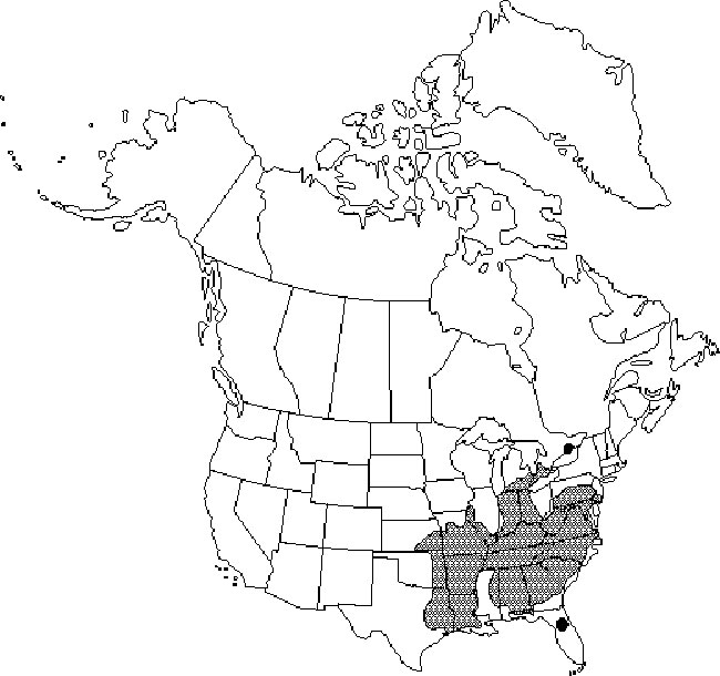
Figure 2: Canadian distribution of Dwarf Hackberry (based on Ambrose 2003).
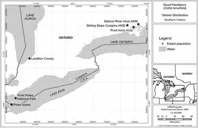
Enlarge Figure 2: Canadian distribution of Dwarf Hackberry (based on Ambrose 2003)
Table 1: Extant Dwarf Hackberry population locations and land management.
| Population | County | Property name | Management | |
|---|---|---|---|---|
| Pelee Island | Essex | Fish Point PNR | Ontario Parks | |
| Pelee Island | Essex | Fish Point road allowance | Township of Pelee Island | |
| Point Pelee NP | Essex | Point Pelee National Park | Parks Canada Agency | |
| Lambton County (aka Ipperwash/ Port Franks/ Northville/ The Pinery Provincial Park) | Lambton | Lambton Co. Heritage Forest | Lambton County (managed by St. Clair Region CA) | |
| Lambton County (aka Ipperwash/ Port Franks/ Northville/ The Pinery Provincial Park) | Lambton | Van Valkenburg property | Nature Conservancy of Canada | |
| Lambton County (aka Ipperwash/ Port Franks/ Northville/ The Pinery Provincial Park) | Lambton | Watson Property (Port Franks Wetlands and Forested Dunes) | Nature Conservancy of Canada | |
| Lambton County (aka Ipperwash/ Port Franks/ Northville/ The Pinery Provincial Park) | Lambton | L-Lake Management Area L-Lake Management Area | Ausable Bayfield CA | |
| Lambton County (aka Ipperwash/ Port Franks/ Northville/ The Pinery Provincial Park) | Lambton | Ausable River Cut (formerly Thedford) Conservation Area | Ausable Bayfield CA | |
| Lambton County (aka Ipperwash/ Port Franks/ Northville/ The Pinery Provincial Park) | Lambton | Port Franks Properties | Ausable Bayfield CA | |
| Lambton County (aka Ipperwash/ Port Franks/ Northville/ The Pinery Provincial Park) | Lambton | The Pinery Provincial Park | Ontario Parks | |
| Lambton County (aka Ipperwash/ Port Franks/ Northville/ The Pinery Provincial Park) | Lambton | Former Ipperwash Military Reserve | Department of National Defence (current steward) Chippewas of Kettle and Stony Point First Nation | |
| Lambton County (aka Ipperwash/ Port Franks/ Northville/ The Pinery Provincial Park) | Lambton | Others | Private | |
| Stirling Slope Complex ANSI | Hastings | Stirling Slope Complex ANSI | Private | |
| Point Anne Alvar | Hastings | Point Anne Alvar | Private | |
| Salmon River Alvar ANSI (aka Lonsdale) | Hastings | Salmon River Alvar ANSI (Lonsdale) | Private |
Key characteristics of the sizes and trends of Dwarf Hackberry populations in Canada are:
- The estimate of 893 mature individuals reported in Canada (Ambrose 2003) is now believed to be an underestimate. New information is available as follows:
- A detailed 2007/8 survey of the Lambton County Heritage Forest, L-Lake Management Area, and Thedford (now Ausable Cut) Conservation Area in the Port Franks/Northville (Lambton County) area documented an estimated 7074 mature trees plus 1518 saplings and seedlings for a total of 8592 Dwarf Hackberry plants. Based on time of year, time constraints, and survey methodology, this is still believed to underestimate population size (Mills and Craig 2008). The current Lambton County population size is now estimated at 13083 trees of all age classes (Mills and Craig 2008, MacKenzie pers. comm. 2010, Ausable Bayfield Conservation Authority unpub. data, Nature Conservancy of Canada unpub. data), but again is likely underestimated.
- More detailed surveys stretching from Grand Bend south to Kettle Point in Lambton County, including a resurvey of the above three sites, are expected to locate a much larger population, including new sites, than has been documented to date (Boyd pers. comm. 2009, Craig pers. comm. 2009, Wilkes pers. comm. 2009).
- Approximate sizes of the other five populations are: Pelee Island (12 trees – Ontario Ministry of Natural Resources [OMNR] unpub. data), mainland Point Pelee National Park (47 trees – Jalava et al. 2008), Point Anne Alvar (10 trees – Ambrose 2003, Natural Heritage Information Centre [NHIC] unpub. data), Stirling Slope Complex ANSI (54 trees – Ambrose 2003, Parks Canada Agency unpub. data), and Salmon River Alvar ANSI (Lonsdale - 5 trees – Ambrose 2003). However, surveys of some private lands at the Point Anne Alvar site have not been undertaken. Further field work is required to evaluate other areas along the ancient Lake Iroquois shoreline in Hastings County where suitable Dwarf Hackberry habitat may exist.
- Overall population trends are considered relatively stable, despite previous concerns raised (Ambrose 2003):
- Although it requires verification, the Point Pelee National Park mainland Dwarf Hackberry population is believed to be experiencing a decline (Ambrose 2003, Jalava et al. 2008).
- Only a few individuals appear to reach a maximum age of 40 to 65 years (Dunster 1992), with much mortality of juveniles and some continuing losses of reproductive individuals due to natural and human disturbances (Ambrose 2003).
- Although the Pelee Island Red Cedar (Juniperus virginiana) Savanna Dwarf Hackberry site has been lost, with the disappearance of the single, mature individual that was located there, no extirpations of any of the six known populations have occurred. The Pelee Island Dwarf Hackberry population persists at Fish Point.
- While it is possible that some Lambton County population gains noted since 2003 may be attributed to a decline in White-tailed Deer (Odocoileus virginianus) abundance, lack of other predators, and/or changing climatic conditions that favour increased recruitment and population expansion, the substantial increase in population size does not likely represent population expansion, but rather is the result of more rigorous surveys locating trees that were already present.
- Range wide, two of six populations have less than ten mature individuals, making them susceptible to extirpation from natural or human disturbances. However, because Dwarf Hackberry is apomictic or self-fertile (Whittemore and Townsend 2007), it is possible for these populations to persist in very low numbers for many decades, as has been noted in Hastings County (Ambrose 2003).
3.3. Needs of the Dwarf Hackberry
In Canada, Dwarf Hackberry occurs in open habitats on dry sand or limestone-based substrates. In sandy sites, it occurs in open habitats near the dynamic, early successional shores of Lake Erie (Point Pelee and Fish Point [Pelee Island]), in open woods further inland on the ridges and south facing slopes of the more aged and stabilized dunes adjacent to Lake Huron’s shoreline (Grand Bend to Kettle Point, Lambton County), and on kame ridge top prairies and savannas above the Trent River (Stirling Slope Complex ANSI). In limestone-based sites (alvars), Dwarf Hackberry occurred in open woods, maintained by extreme droughty conditions, in the interior of Pelee Island (Red Cedar Savanna), and continues to occur at the Point Anne Alvar and the Salmon River Alvar ANSI (Lonsdale) in Hastings County (Ambrose 2003). Other disturbances, such as trails, help, in some cases, to maintain suitable open habitat. The sandy soils where Dwarf Hackberry occurs tend to have a large calcareous component and a pH above 7. At the most inland site (Stirling Slope Complex ANSI), soils are dry to wet-mesic sand and gravel loams, with a slightly acid to neutral pH (NHIC 2010d).
Several plant communities in which Dwarf Hackberry occurs are considered rare to extremely rare (e.g. shrub and treed sand dunes, oak savannas, and Red Cedar treed alvars), and have limited distribution in southern Ontario (Ambrose 2003). Oak savannas are known to require occasional fires to ensure maintenance of the ecosystem. Although the fire ecology of Dwarf Hackberry in Canada is unknown, research from the United States indicates that prescribed burns in Dwarf Hackberry habitat resulted in the emergence and persistence of the species where it was previously absent (Taft 2003). Sand dune habitats require the active disturbance mechanisms of wind, wave, and ice action to maintain them in the early successional stages favoured by Dwarf Hackberry. Location (dune ridges) and aspect (south facing slopes), along with wind throw, fire, insect infestations, and/or disease may help to maintain suitable habitat on older, more stabilized dunes. Alvar habitats are prone to extremes of temperature and moisture that make them inhospitable for many species, but suitable, in at least some locations, for Dwarf Hackberry.
As a moderately shade intolerant species, the availability of light becomes a limiting factor for the species as ecosystem disturbances naturally slow or are altered by humans. Forest openings and edges appear to be important for effective seedling germination and recruitment, as is some level of soil disturbance. Within Dwarf Hackberry habitat, fruits fall onto microsites that have the following optimum conditions necessary for seed germination and seedling survival:
- the site is protected from desiccating (drying) winds and burial by shifting sand;
- the soil contains humus, which retains moisture and provides nutrients;
- seeds are covered, but not buried, by leaf litter or plant debris, which reduces the chances of consumption by wildlife and provides protection from frost kill; and
- the site is positioned to receive the required amount of light and heat necessary to break dormancy and allow the seedlings to photosynthesize (Dunster 1992).
Primary long-distance seed dispersal is most likely carried out by fruit-eating birds, although the species responsible in Canadian populations are unknown. Germination is stimulated by weakening of the seed coat by acids in a bird’s gut (Dunster 1992) and fruit-eating birds have been observed to disperse more seeds in tree fall gaps than the surrounding forest (Hoppes 1988). How the seeds are consumed and dispersed have implications for the distance of individual dispersal events, and thus the genetic mixing or isolation of sub-populations. Squirrels, mice and other small mammals may also play a secondary dispersal role, but they are more likely to consume or otherwise damage a higher proportion of the seeds that they come in contact with. Long-distance seed dispersal is therefore believed to be a limiting factor (Dunster 1992).
4. Threats
Since Dwarf Hackberry was designated as Threatened (COSEWIC 2003), additional threats have come to light, including the role of altered disturbance regimes in accelerating habitat succession, the grazing impacts of snails, inappropriate logging activities, development, certain recreational activities, and others (Section 4.2.9). Threats to the species were reassessed in 2009 at a recovery strategy writing workshop. Major threats are presented in order of priority in Table 2. The overall level of concern (high, medium, or low), extent (range wide or local), occurrence (current or anticipated), frequency (one-time, seasonal, continuous, recurrent, or unknown), severity, and causal certainty of the threats on Dwarf Hackberry populations are presented in the table for each.
4.1. Threat assessment
Table 2: Threat assessment table.
Changes in ecological dynamics or natural processes
| Priority | Threat | Level of concern | Extent | Occurrence | Frequency | Severity | Causal certainty |
|---|---|---|---|---|---|---|---|
| 1 | Altered disturbance regimes (coastal processes, fire, wind throw, disease) | Medium | Range wide | Current | Continuous | Medium | Medium |
Natural processes or activities
| Priority | Threat | Level of concern | Extent | Occurrence | Frequency | Severity | Causal certainty |
|---|---|---|---|---|---|---|---|
| 2 | Bark beetles | Medium | Local | Unknown | Unknown | High | High |
| 3 | Snails | Medium | Local | Unknown | Unknown | Low-High | High |
Disturbance or harm
| Priority | Threat | Level of concern | Extent | Occurrence | Frequency | Severity | Causal certainty |
|---|---|---|---|---|---|---|---|
| 4 | Inappropriate logging activities | Medium | Local | Historic Current anticipated | Seasonal | Low | Medium |
Habitat loss or degradation
| Priority | Threat | Level of concern | Extent | Occurrence | Frequency | Severity | Causal certainty |
|---|---|---|---|---|---|---|---|
| 5 | Development (e.g. cottage, rural residential, agricultural and commercial) | Medium | Almost range wide | Historic current? anticipated |
Continuous | Unknown | Low |
| 6 | Aggregate extraction | Medium | Almost range wide | Historic current? anticipated |
Unknown | Unknown | Low |
Exotic, invasive, or introduced species/genome
| Priority | Threat | Level of concern | Extent | Occurrence | Frequency | Severity | Causal certainty |
|---|---|---|---|---|---|---|---|
| 7 | Plant competition (e.g. allelopathic tree species, exotic or invasive plants) | Low-Medium | Range wide | Current | Continuous | Low-Medium | Low-Medium |
Disturbance or harm
| Priority | Threat | Level of concern | Extent | Occurrence | Frequency | Severity | Causal certainty |
|---|---|---|---|---|---|---|---|
| 8 | Recreational activity (off-road vehicle traffic, trampling, trail maintenance, horses, and firewood collection) | Low | Range wide | Current | Continuous | Low | Low-Medium |
4.2. Description of threats
4.2.1. Altered disturbance regimes
At many sites, a lack of natural disturbances (fire) or altered patterns, frequency, and severity of disturbance regimes (coastal processes at Point Pelee National Park and Fish Point [Pelee Island], wind throw and disease) threatens Dwarf Hackberry and its habitat. European settlement brought with it fire suppression. The resultant resource (water, nutrient, and light) competition from other plants (native, clonal, allelopathic
Extensive shoreline protection and alteration has disrupted the natural coastal processes that shape the dynamic Point Pelee and Fish Point sand spits. The western shoreline of Point Pelee National Park was historically an accreting or growing shoreline. Between 2004 and 2006 however, it eroded an average of 5.5 m per year. The Colchester to Southeast Shoal Beach Nourishment Study (Baird 2010) determined that, without erosion mitigation measures and sand replenishment in the littoral cell, 126 hectares could be lost from the western shore within the next 50 years. Increased erosion means less land is available for Dwarf Hackberry germination and that trees are closer to the shore and more susceptible to the uprooting action of storm waves and ice.
4.2.2. Bark Beetles
Between 1989 and 1991, there was an epidemic infestation of the large reproducing Dwarf Hackberry trees in Point Pelee National Park. Tree mortality was documented at 10% per year for a two-year period, rising to 17% in the third year (Dunster 1992). Seven native species of bark beetles (Hickory Bark Beetle [Chramesus hicoriae], Beech Bark Beetle [Scolytus fagi], Hackberry Engraver Beetle [Scolytus muticus], Asian Ambrosia Beetle [Xyleborinus saxeseni], Black Stem Borer [Xylosandrus germanus], an ambrosia beetle [Hypothenemus eruditus], and Phloeotribus dentrifrons) were found. The Asian Ambrosia Beetle was also recorded from the Port Franks (Lambton County Heritage Forest [Lambton County]) area (Dunster 1992, Bright et al. 1994). Bark beetles are integral species in forest ecosystems and are attracted to trees by chemicals, called monoterpenes, produced in resin, and released from freshly damaged bark. Bark beetles are known to detect stress in plants and invade weakened trees. Adults burrow through the bark to lay eggs, while their larvae burrow and feed under tree bark. Natural predators of bark beetles include woodpeckers and parasitic insects. Given the impact of other bark beetles (16.3 million ha. of dead Lodgepole Pine [Pinus contorta] in British Columbia due to the Mountain Pine Beetle [Dendroctonus ponderosae] and millions of dead trees in southwestern Ontario and the Great Lakes states due to the Emerald Ash Borer [Agrilus planipennis]), this threat should not be taken lightly. The reasons for a stress event at Point Pelee National Park are unknown and could be attributed to many factors such as climate change, plant overcrowding, and loss of bark beetle predators. The extent to which these beetle species also utilize Common Hackberry (C. occidentalis), which occurs in habitat adjacent to Dwarf Hackberry, is also unknown. Bark beetle problems were not observed during the 2002 survey to update the COSEWIC report (Ambrose pers. comm. 2009). The presence and current level of impact at sites where these beetles were originally detected is unknown. Several of the bark beetle species are known to be expanding their ranges northwards from the United States (Dunster 1992), and warmer winter weather due to climate change could result in another northwards expansion toward the Lake Huron population.
4.2.3. Snails
Seedling grazing by the native Webbhelix [syn. Triodopsis] multilineata, a very rare to rare species tracked by the NHIC, was observed in epidemic proportions in 1989/90 at Point Pelee National Park and is considered a major threat to population demographics. In an experiment, 62% of 365 Dwarf Hackberry seedlings were chewed to the ground by three snails within 24 hours of having been located (Dunster 1992). Whether this snail species is present and having the same level of impact today is unknown.
High intensity grazing is thought to be related to the high density of a species in one place (Ridley 1930, quoted in Harper 1977). Since Dwarf Hackberry is not an abundant species at Point Pelee National Park, it may be a victim of snail grazing due both to its proximity to the abundant Common Hackberry and to the morphological similarity between the two species (Dunster 1992). It is suspected that grazing events may be episodic, potentially related to climate conditions that stress all hackberry species and lead to epidemic grazing (Dunster 1992). Consistent seedling grazing reduces both population numbers and the opportunities for seedlings to become reproductive adults that yield seed for local recruitment and long distance dispersal.
It is uncertain whether the seed bank contains sufficient seeds to perpetuate the population at Point Pelee National Park if continued snail grazing occurs. No snails were observed around Dwarf Hackberry in the Lambton County Heritage Forest (Lambton County) and it is unknown if snail grazing is an issue at any other site in Lambton County or within the Hastings County populations.
4.2.4. Inappropriate logging activities
Active forest management can lead to habitat loss or creation. Uninformed, poorly planned and/or implemented forest management can be detrimental to the health and survival of Dwarf Hackberry populations. Negative effects include understory removal and the breaking, crushing, or bark abrasion of Dwarf Hackberry trees due to the felling and skidding of trees; smothering of seedlings by slash piles; soil erosion and compaction; reforestation with monoculture pine stands or other inappropriate species; and loss of habitat connectivity. Over time, this can result in a species' decreased ability to adapt to change and its potential extirpation from sites.
4.2.5. Development
Habitat conversion through land development for cottage, rural residential, agricultural, and commercial purposes poses a moderate threat to Dwarf Hackberry populations. The Lambton County population south of Grand Bend, the largest in Canada, currently faces the greatest development pressures. The northeast corner of the Salmon River Alvar ANSI (Lonsdale), where Dwarf Hackberry is located, is also being surrounded by development. Habitat fragmentation leading to less suitable habitat between populations and sub-populations and the respective dwindling number of individuals may reduce opportunities for seed dispersal and gene exchange, leading to genetic bottlenecks and a reduction in population size. Over time, this can result in a decreased ability to adapt to change, which can lead to extirpation. Fragmentation likely also impacts habitat for seed dispersers, reducing optimal seed dispersal through loss of suitable habitat.
4.2.6. Aggregate extraction
Sand and limestone removal has the potential to lead to habitat loss, fragmentation, and isolation in four of six populations. The Point Anne Alvar population in Hastings County occurs on an alvar, portions of which are within a privately owned, active, licensed, limestone quarry. The Port Franks Road (Lambton County) site is adjacent to a sand pit used for road maintenance. Expansion of an adjacent, active sand pit is considered a threat to the Stirling Slope Complex ANSI Dwarf Hackberry population, while the potential for future limestone quarrying to expand from a quarry to the south of the Salmon River Alvar ANSI (Lonsdale) may also be a concern.
4.2.7. Plant competition
Exotic and/or invasive plants and allelopathic tree species compete with Dwarf Hackberry for water, nutrient, and light resources. Invasive, exotic species of concern at Point Pelee National Park include Garlic Mustard (Alliaria petiolata), European/Common Buckthorn (Rhamnus cathartica), Norway Maple (Acer platanoides), White Mulberry (Morus alba), and White Sweet Clover (Melilotus alba). Nitrogen-fixing species, like the latter, improve soil conditions for other species that normally could not establish themselves in the nutrient depleted environments that Dwarf Hackberry can, and therefore increase competition and shading by other species. Garlic Mustard and White Mulberry are also present at Fish Point (Pelee Island), while the former is also a concern in the Lambton County population (Grand Bend to Kettle Point). European/ Common Buckthorn is of concern in the Port Franks/Northville (Lambton County) area and at the Point Anne Alvar (Brinker pers. comm. 2010).
As hackberries are themselves known to be allelopathic, the positive, negative, and synergistic (combined) impacts of allelopathic inhibition by other species on Dwarf Hackberry trees and plant communities are unknown. However, allelopathic species that may be of concern include Common Hackberry, Fragrant Sumac (Rhus aromatica), Red Cedar, and Common Juniper (Juniperus communis). Poison Ivy (Toxicodendron radicans), Drummond’s Dogwood (Cornus drummondii), Fragrant Sumac, Common Juniper, and Witch Hazel (Hamamelis virginiana) can crowd out Dwarf Hackberry through their growth habits. In the Lambton County Heritage Forest (Lambton County), areas with dense populations of Witch Hazel have little or no Dwarf Hackberry and vice versa (Mills and Craig 2008). Low populations of both species were found growing amongst each other, which would eliminate competitive exclusion
This relationship may be due to niche differentiation
4.2.8. Recreational activity
A variety of recreational activities result in damage to Dwarf Hackberry trees of all age classes, soil disturbance, erosion, and/or the introduction of invasive and/or exotic plants into critical habitat. Unregulated recreational activities noted on private lands in the Port Franks area (Lambton County) include off-road vehicle use on steep dune slopes that may cause direct damage to Dwarf Hackberry as well as its habitat through erosion and dune blowouts. As Dwarf Hackberry seedlings often germinate in forest gaps, including trailside locations, off-road vehicle use, horseback riding, and hiking, even when confined to trails, can potentially lead to the trampling, crushing, and destruction of seedlings. Although many sites do not permit off-road vehicle use, such vehicles have been noted as a problem to varying degrees in the Lambton County Heritage Forest (Lambton County), Nature Conservancy of Canada’s Van Valkenburg property (Lambton County), and Fish Point (Pelee Island) where trees occur next to a parking area on a road allowance.
Lake Erie (Point Pelee National Park and Pelee Island) and Lake Huron (Lambton County) populations occur within and adjacent to a national park and several provincial parks, nature reserves, county forests, and conservation areas. These areas receive high volumes of visitors during the summer months. Collection of firewood, even when not permitted, could be an issue where campfires and/or the use of rustic barbecues are permitted. Trail brushing and maintenance, typically a winter activity, can also have a direct impact on Dwarf Hackberry that grows alongside trails at several sites.
4.2.9. Other threats
Other threats identified in 2009, but considered unsubstantiated, unavoidable, or currently of lesser importance to Dwarf Hackberry are:
- Unexploded ordinance removal and chemical contaminant clean-up – unavoidable, recurrent events that must be undertaken to ensure public safety at the former Camp Ipperwash Military Reserve (Lambton County) have a high likelihood of destroying some Dwarf Hackberry trees and habitat. Population level impacts are expected to be small. Application of specific measures identified in the Canadian Environmental Assessment Act assessment may mitigate the impacts.
- Chemicals - seasonal fertilizer and herbicide use (low causal certainty, severity, and level of concern) adjacent to the Lambton County Heritage Forest (Lambton County).
- Deer and domestic animal browse – Browsing of Dwarf Hackberry by White-tailed Deer (low causal certainty, severity, and overall concern) occurs range wide. Normally confined to the winter months, it becomes a continuous threat when deer populations are high. Browsing by cows is a current and continuous concern of medium causal certainty, low severity, and low overall level of concern along the south edge of the Lambton County Heritage Forest west of the Port Franks Road (Lambton County).
- Climate change – Climate change is widespread, current, and continuous. However, its potential effects on Dwarf Hackberry are unknown. Drier conditions could provide Dwarf Hackberry with a competitive advantage over Witch Hazel. However, if changes are too severe and quick for Dwarf Hackberry to adapt, extirpations may result. Seedlings in already harsh alvar environments may not be able to survive greater extremes of dryness and heat. Drought conditions are already thought to be responsible for making the species more susceptible to attack by detrimental species at Point Pelee National Park (Dunster 1992). In addition, severe drought could kill other dune-stabilizing vegetation, causing erosion, dune destabilization, and blowouts that would result in the loss of plants and habitat. In addition, climate change is expected to intensify storm events, increasing wind and wave driven shoreline erosion, while reducing the amount of ice cover and associated scour. On the other hand, if Dwarf Hackberry survives the new and changing environment, seeds could be dispersed to suitable, but previously unoccupied, habitats further north of its current range extent.
- Road construction – the construction of Outer Drive and Port Franks Road 3 likely had historic impacts on the Lambton County Dwarf Hackberry population. At the former Camp Ipperwash Military Reserve (Lambton County), temporary roads will be used during clean-up of the unexploded ordinance and contaminants. They will be located, to the extent possible, in areas that do not contain species at risk in order to avoid population-level effects.
Several Dwarf Hackberry sites, especially those in Hastings County, have small populations that are isolated from others. A few populations appear to be based on single or a few reproductive individuals. The cumulative effects of the above threats may be compounded by the small size of these populations, which are predisposed to stochastic (random) events and demographic collapse (i.e. populations may become too small to sustain themselves). Hybridization with Common Hackberry is no longer considered to be a threat (Whittemore and Townsend 2007).
5. Population and distribution objectives
The designation of Dwarf Hackberry based on a decline in area, extent, and quality of habitat, less than 2500 mature individuals in Canada, less than 1000 in any population and an extent of occurrence less than 20000 km2 is no longer valid based on the findings of Mills and Craig (2008). Given the naturally small area of occupancy of the species in Canada and the large gaps that occur between populations, it is neither realistic nor appropriate to expand its area of occupancy beyond 500 km2 or to focus on reducing population fragmentation. For these reasons, the main focus for the recovery of this species is to maintain existing populations and prevent declines and extirpations. The population and distribution objectives for Dwarf Hackberry are therefore:
- to halt the apparently steep decline in the species' population size at Point Pelee National Park and
- to maintain populations at the other five extant locations (Pelee Island, Lambton County, Point Anne Alvar, Stirling Slope Complex ANSI, and Salmon River Alvar ANSI [Lonsdale]) in suitable habitat.
Special focus is placed on the Point Pelee National Park population as survey information suggests that it is currently in a steep decline (Jalava et al. 2008). All other populations appear to be stable.
Key to the achievement of these population and distribution objectives over the long term is the restoration and maintenance of the natural disturbance mechanisms that provide for long term persistence of critical habitat. This is particularly true at Point Pelee National Park where the alteration of coastal processes, and potentially the suppression of fire, has contributed to aggressive plant competition and the unnaturally rapid succession of open vegetation communities suitable for Dwarf Hackberry maintenance to more closed, shaded conditions.
6. Broad strategies and general approaches to meet objectives
6.1. Actions already completed or currently underway
Efforts to update the population size and distribution data for the Dwarf Hackberry in Canada have been initiated. Recent surveys have been completed in Point Pelee National Park (Jalava et al. 2008), the Lambton County Heritage Forest (Lambton County) (Mills and Craig 2008), and one Stirling Slope Complex ANSI property (Parks Canada Agency unpub. data). Dwarf Hackberry is a nested conservation target species of the Carolinian Canada Coalition’s Ausable River – Kettle Point to Pinery Conservation Action Plan (Jalava et al. 2010). A community- based biodiversity strategy for the Port Franks area of Lambton County is now in preparation (Jalava pers. comm. 2010). Dwarf Hackberry has been a key consideration in the development and implementation of management plans for Nature Conservancy of Canada sites managed by Lambton Wildlife Incorporated in this area. The species will also benefit from conservation goals and actions to improve the viability of the "beaches and shorelines" biodiversity target in the Essex Forests and Wetlands Conservation Action Plan, where it has been recognized as a significant species (Essex Forests and Wetlands Conservation Action Plan Team 2009). Communications include a web based species at risk fact sheet (Royal Ontario Museum and OMNR 2008) and messaging incorporated into programming and communications at Point Pelee National Park. The Carolinian Canada Coalition has published numerous conservation and stewardship guidance and information documents to assist landowners in the overall protection and management of species and ecosystems at risk.
6.2. Strategic direction for recovery
In order to attain the Population and Distribution Objectives, the recovery planning approaches are summarized and ranked in Table 3 by their degree of urgency. Threats to the populations and information requirements are addressed. These approaches will be planned with due regard for negative impacts on other species.
Table 3: Recovery planning table.
| Threat or limitation | Priority | Broad strategy to recovery | General description of research and management approaches |
|---|---|---|---|
| All | High | Conduct population and habitat surveys and monitoring |
|
| All | High | Communicate Best Management Practices (BMPs) and other important facts |
|
| All | High | Coordinate recovery approaches |
|
| Altered disturbance regimes | High | Mitigate erosion threats |
|
| All | Medium | Engage landowners to plan and implement protection and recovery measures. |
|
| All | Medium | Encourage the use of Traditional Ecological Knowledge in decision making |
|
| Inappropriate logging Development Aggregate extraction | Medium | Implement stewardship agreements |
|
| Aggregate extraction | Medium | Protect Dwarf Hackberry trees and habitat from resource extraction |
|
| Altered disturbance regimes Plant competition | Medium | Vegetation management |
|
| Snails Deer browse | Medium | Investigate and implement measures to manage herbivory |
|
| Bark beetles Snails Plant competition | Medium | Complete/refine threat assessment |
|
| Altered disturbance regimes | Medium | Research niche differentiation |
|
| Lack of basic Information | Medium | Research seed dispersal |
|
| Altered disturbance regimes | Medium | Research fire effects |
|
| Lack of basic information | Medium | Research small, isolated populations |
|
| Lack of basic information | Medium | Research genetic differences |
|
| All | Low | Population repatriation and augmentation |
|
| Recreational activity | Low | Minimize recreational impacts |
|
| Climate change | Low | Reduce climate change |
|
6.3. Narrative to support the recovery planning table
Surveys
Sutherland et al. (1994) reported that Dwarf Hackberry was found at Parkhill in Middlesex County. The origin of this information is unknown and the record does not appear to have been field checked or verified. Gartshore (pers. comm. 2009) and others have reported possible Dwarf Hackberry trees on the rim of the Niagara Gorge at the Niagara Butterfly Conservancy in Niagara Falls. Slight differences in morphology suggest that they might be escapees from the Niagara School of Horticulture (Niagara Parks Commission). Verification is required.
Additional suitable habitat may exist along the Lake Erie shore, Niagara River islands and shoreline, Lake Huron shore from Grand Bend to Kettle Point, on Pelee Island and Hastings County alvars, and the shoreline of historic Lake Iroquois in Hastings County. These areas need to be investigated for new individuals and/or populations.
Research
Knowledge about Dwarf Hackberry ecology in Canada is the result of a single PhD thesis (Dunster 1992) that examined two populations (Point Pelee National Park and Northville/Port Franks [Lambton County]). Significant knowledge gaps remain regarding the other four populations. As such, Table 3 identifies research that is needed to complete critical habitat identification and achieve the recovery strategy objectives for Dwarf Hackberry. Knowledge gained regarding genetic differences within and between populations, in particular, will inform any restoration and augmentation activities deemed feasible.
First Nation communities have maintained local ecosystems for generations through the use of community Traditional Ecological Knowledge. It is important to work with knowledge holders as a means for species and ecosystem protection and recovery. Traditional Ecological Knowledge and western science can, together, better inform assessment, monitoring, and recovery of the ecosystems that support specific species at risk.
Communicate best management practices and other important facts
There are many activities that can be undertaken by landowners and land managers independently or jointly to promote Dwarf Hackberry recovery. Communication of appropriate activities and promotion and support of stewardship is key to Dwarf Hackberry recovery. Naturally occurring fire, wind throw, insect infestation, disease, and other disturbances would have maintained the open gaps and edges for Dwarf Hackberry colonization and persistence in the past. To the extent possible, such natural processes should be allowed to continue, or should be restored or mimicked. While inappropriate logging practices can threaten Dwarf Hackberry, selective harvesting using good forestry practices can also provide the critical open edge and/or forest gap conditions that promote establishment and regeneration of Dwarf Hackberry and can potentially reduce the impacts of competing species like Witch Hazel. Well-planned and carefully implemented forest management practices need to be considered in some areas, such as the Lambton County Heritage Forest (Lambton County), to promote recovery and prevent population declines (i.e. remove exotic pine plantations and restore more open habitat). It should be noted that habitat restoration activities required to address the threats of exotic and/or invasive species and/or habitat succession will result in some reduction of canopy cover. These actions, in locations where these issues have been identified as a threat(s), are deemed necessary and are not considered destruction of critical habitat, provided that the alterations promote greater use of the habitat by Dwarf Hackberry.
7. Critical habitat
Critical habitat is defined in section 2(1) of SARA (2002) as "the habitat that is necessary for the survival or recovery of a listed wildlife species and that is identified as the species' critical habitat in the recovery strategy or in an action plan for the species." In order to achieve the population and distribution objectives, this recovery strategy identifies critical habitat for the Dwarf Hackberry across its range in Canada, to the extent possible at this time.
7.1. Identification of the species' critical habitat
The locations and attributes of critical habitat were identified using the best available information, including observation data, indicating the presence of a single tree or a cluster of trees. In other circumstances, while specific point locations were not available, the species had been documented as occurring within a particular vegetation type(s) on a specific property. These data were collected by regional, provincial, and federal agencies and their contractors, as well as by non-government organizations and individuals over the course of many years. Locations of known Dwarf Hackberry trees were obtained from Norris (1994), Brownell and Blaney (1995), Mills and Craig (2008), Ambrose (unpub. data), Ausable Bayfield Conservation Authority (unpub. data), OMNR (unpub. data), Nature Conservancy of Canada (unpub. data), NHIC (unpub. data), and Parks Canada Agency (unpub. data). Additional map components were provided by OMNR's Land Information Ontario and the North American Atlas (Figures 4 – 12, 14, and 16), Ausable Bayfield Conservation Authority (Figures 6 and 9), St. Clair Region Conservation Authority (Figures 10 and 11), Nature Conservancy of Canada (Figures 5 and 10), and Dougan and Associates (2007) and Parks Canada Agency (Figure 4).
Biophysical attributes and geographic locations of critical habitat
Across the species' range, the biophysical attributes of Dwarf Hackberry critical habitat include open to moderately vegetated areas, often with a relatively high level of natural disturbance or harsh environmental conditions. These attributes occur in the following locations and situations:
- dry, sandy, well-drained sites with open, early successional habitats near the shores of:
- Lake Erie: along the leading edge of woody, shoreline vegetation adjacent to woodland or forest and in adjacent shrub and/or treed sand dune, shrub shoreline, and deciduous thicket communities at Point Pelee National Park (Jalava et al. 2008) and Fish Point (Pelee Island),
- Lake Huron: at inland, ancient Lake Warren dune sites in tallgrass savanna communities and along dry oak/pine woodland and forest edges, in natural forest canopy gaps, on the tops of dune ridges and mounds, and on steep, south-facing dune slopes from Grand Bend to Kettle Point (Lambton County – Dunster 1992, Mills and Craig 2008) and,
- Hastings County (Stirling Slope Complex ANSI): on kame ridge top prairie and savanna remnants above the Trent River along the ancient Lake Iroquois shoreline (Brownell and Blaney 1995), and
- open woods, maintained by extreme droughty conditions, on dry, calcareous, alvar and/or treed rock barren sites at Point Anne Alvar, the Salmon River Alvar ANSI (Lonsdale), and historically in the interior of Pelee Island (Red Cedar Savanna) (Norris 1994, Ambrose 2003, NHIC 2010a, 2010b, 2010c).
General locations of Dwarf Hackberry critical habitat are shown in Figure 3. Site-specific critical habitat maps for 20 critical habitat parcels, covering the six extant populations, are provided in Appendix B.
Critical habitat based on vegetation type
Ecological land classification vegetation type mapping
Occupancy-based approaches were used to identify critical habitat for the Dwarf Hackberry across its Canadian range: Where data were available to identify a Dwarf Hackberry tree or trees within one or more Ecological Land Classification
- Point Pelee National Park, Leamington, Essex County, Ontario (critical habitat parcel #247_3, Figure 4): the occupied Red Cedar Treed Sand Dune and Hoptree Shrub Sand Dune ELC vegetation types adjacent to the shores of Lake Erie (Lee 2004, Dougan & Associates 2007, Jalava et al. 2008).
- Van Valkenburg property (Lambton County), Lambton Shores, Lambton County, Ontario (parcel #247_4, Figure 5): the occupied Dry Black Oak – Pine Tallgrass Savanna ELC vegetation type (Nature Conservancy of Canada unpubl. data).
- Port Franks Properties (Lambton County), Port Franks, Lambton County, Ontario (parcel #247_11, Figure 6): the ELC vegetation type labelled PFP06 (Ausable Bayfield Conservation Authority unpub. data). Given that the specific ELC vegetation type associated with the PFP06 polygon has not yet been defined, only the areas within this boundary that meet the biophysical description of critical habitat outlined in this section are considered critical habitat.
Other types of habitat mapping
When ELC data was not available, other types of available habitat mapping were used to identify Dwarf Hackberry critical habitat, as follows:
- Salmon River Alvar ANSI (Lonsdale), Lonsdale, Hastings County, Ontario (parcel #247_20, Figure 7): the occupied Very Dry Treed Barrens on Limestone Bedrock plant community (Norris
1994, Ambrose 2003). - Stirling Slope Complex ANSI, Frankford, Hastings County, Ontario (parcel #247_13, #247_15, and 247_17, Figure 8): vegetation community 2e, a Kame Ridge Top Dry-Mesic Prairie Remnant and vegetation community 3e, Kame Ridge Top Savannas (Brownell and Blaney 1995, Ambrose 2003). Additional critical habitat and an area within which critical habitat is found are identified within this ANSI based on the known locations of individual trees (Parks Canada Agency unpub. data).
Figure 3: General locations of critical habitat for Dwarf Hackberry in Canada.
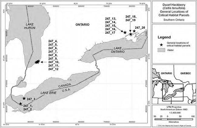
Enlarge Figure 3: General locations of critical habitat for Dwarf Hackberry in Canada
Critical habitat based on observations of trees
Areas of Dwarf Hackberry occurrence
Where no vegetation community mapping was available, but areas of Dwarf Hackberry occurrence had been mapped within the last 20 years, these areas were identified as critical habitat, as follows.
- Ausable River Cut (formerly Thedford) Conservation Area (Lambton County), Northville, Lambton County, Ontario (parcel #247_10, Figure 9): the Dwarf Hackberry area delineated on the property in Mills and Craig (2008).
- Lambton County Heritage Forest (Lambton County), Port Franks, Lambton County, Ontario (parcel #247_9, Figure 10): vegetation unit 3B (Mills and Craig 2008). An additional area within which critical habitat is found is identified on this property based on the known locations of individual trees (Nature Conservancy of Canada unpub. data).
- L-Lake Management Area (Lambton County), Port Franks, Lambton County, Ontario (parcel #247_6, Figure 11): the Dwarf Hackberry area delineated on the property in Mills and Craig (2008). An additional area of critical habitat is identified on this property based on the location of a few trees near the entrance to the property (Mills and Craig 2008).
Point data representing Dwarf Hackberry occurrences
Dwarf Hackberry is a moderately shade intolerant species that does not typically occur within closed canopy forest. Forest succession and canopy closure creates unsuitable habitat that can result in local extirpations. ELC and other available mapped vegetation community data are not detailed enough within forested habitats to identify tree gaps, southern facing slopes, dune ridges, and ecotones or open edges that provide localized suitable habitat. As such, occupied ELC forest vegetation types have been excluded from critical habitat. Instead, where possible, an occupancy approach, based on the observation of trees, was applied, as it is better able to represent localized microhabitats in the forest that are suitable for Dwarf Hackberry. Where habitat data are not available or suitable (e.g. closed canopy forest) and areas of the species' occurrence have not been mapped, critical habitat is based on UTM (Universal Transverse Mercator coordinate system) locations of individual trees or clusters of trees, obtained using a GPS (geographic positioning system) unit. Coordinates obtained using this technology are expected to be accurate to at least 10 m.
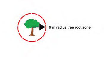
Critical habitat is identified as a circle with a radius of 9 m surrounding the trunk of each known, live, individual, naturally occurring Dwarf Hackberry tree (see Figure 12) at identified locations. This is based on a critical root zone definition, used as a zone of protection for trees, of up to 36 times the diameter at breast height (dbh
Figure 13: Conceptual illustration of critical habitat (9 m radius tree root zone) around a single Dwarf Hackberry tree.
For single data points representing more than one Dwarf Hackberry tree, the number of trees that the point represents was multiplied by the critical habitat area for a single tree (π r2 = π 92 = 254 m2 rounded to the nearest m2), and then dividing by pi (π). The square root of the result, rounded to the nearest metre, was then applied as the radius of the tree root zone around the known GPS data point in order to delineate an area within which critical habitat is found for the number of trees in that cluster. Critical habitat within this area is represented by any area satisfying any one of the biophysical attributes of critical habitat previously described along with the full tree root zone of each individual tree falling within this area (this tree root zone may extend beyond the area within which critical habitat is found). This approach was applied to create critical habitat parcel #247_5 (Figure 11) at L-Lake Management Area, Port Franks, Lambton County, Ontario (Lambton County – Mills and Craig 2008) and parcel #247_2 (Figure 14) along the municipal right of way at Fish Point, Pelee Island, Ontario (Pelee Island – OMNR unpub. data).
For locations where more than one Dwarf Hackberry data point exists:
- Watson Property (Lambton County), Port Franks, Lambton County, Ontario (parcel #247_7, Figure 10): (Nature Conservancy of Canada unpub. data),
- Lambton County Heritage Forest (Lambton County), Port Franks, Lambton County, Ontario (parcel #247_8, Figure 10): (Nature Conservancy of Canada, unpub. data),
- Stirling Slope Complex ANSI, Frankford, Hastings County, Ontario (parcel #247_16, Figure 8): (Parks Canada Agency unpub. data), and
- Point Anne Alvar, Point Anne, Hastings County, Ontario (parcel #247_18, Figure 12): (Ambrose 2003, NHIC unpub. data),
the area within which critical habitat (based on biophysical attributes) is found also includes all habitats, excluding wetlands, that fall within a shape that encompasses the tree root zone of all Dwarf Hackberry trees or clusters of trees for which data points exist (see Figure 15A). In these instances, the area within which critical habitat is found is represented by a minimum convex polygon
Figure 15: Conceptual illustration of A) the area within which critical habitat is found for locations that have two or more Dwarf Hackberry trees separated by 100 m or less and B) a distance greater than 100 m between Dwarf Hackberry trees resulting in separate polygons related to critical habitat for each population.
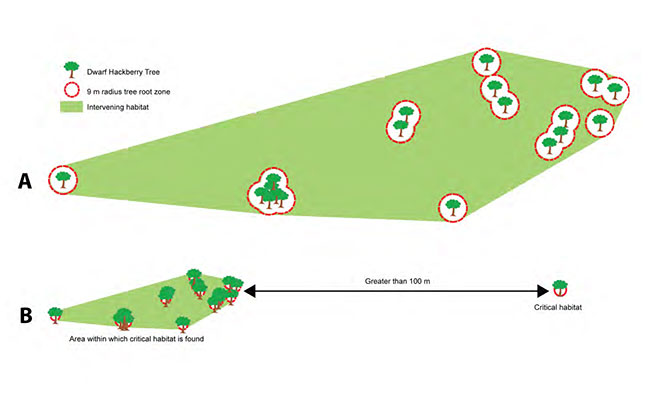
Within Fish Point Provincial Nature Reserve (Pelee Island) (parcel #247_1, Figure 14) and The Pinery Provincial Park, Lambton Shores (Lambton County) (parcel #247_12, Figure 16), an area within which critical habitat is found is delineated as a circle of 9 m radius surrounding the trunk of each individual, naturally occurring Dwarf Hackberry within each park, plus all habitats within a shape that encompasses the tree root zone of all Dwarf Hackberry trees that are within 100 m from one or more other Dwarf Hackberry trees, excluding wetlands, which are unsuitable habitat. The area within which critical habitat is found has been mapped.
Critical habitat exclusions
Critical habitat has not been identified for trees that are known to have been planted or transplanted. Records that are older than 20 years (pre 1990), with no verification through follow-up surveys, were deemed historical and were also not considered during critical habitat identification. Existing anthropogenic features, including existing infrastructure (e.g. roads, trails, parking lots, utility corridors, and buildings), existing cultivated areas (e.g. agricultural fields), or unnatural vegetation types (e.g. grassed areas and septic beds) are excluded from critical habitat as they are not suitable habitats for the long-term persistence of this species. Areas where Dwarf Hackberry trees are found in or adjacent to anthropogenic features (e.g. in utility corridors like hydro or adjacent to roads and trails etc.) are also excluded from critical habitat in locations where their presence is opportunistically related to the existence of these features (i.e. in locations other than suitable, naturally-occurring vegetation types where the species would be expected to be found without the presence of the anthropogenic feature). Should these anthropogenic features disappear in areas of unsuitable habitat (e.g. through trail, road, or hydro corridor removal or abandonment), the Dwarf Hackberry trees present might remain for some time, but would not be expected to continue to reproduce, nor would seedlings be anticipated to germinate under the full canopy cover that would eventually result from natural succession. As on-going maintenance of these areas as suitable habitat for Dwarf Hackberry individuals cannot be guaranteed, and without utility corridor maintenance these areas would quickly become unsuitable for Dwarf Hackberry, these areas cannot be expected to contribute to short- or long-term population and distribution objectives. In addition, it is not believed thatthese sites are required in order to achieve the population and distribution objectives.
7.2. Schedule of studies to identify critical habitat
While critical habitat has been identified for each of the six Dwarf Hackberry populations, further work is required to refine critical habitat identification and determine if additional critical habitat is required to achieve the population and distribution objectives for the species. This work is outlined in Table 4 below.
Table 4: Schedule of studies.
| Description of activity | Rationale | Timeline |
|---|---|---|
|
Survey extant populations to determine:
|
This information is needed to ensureprotection of sufficient critical habitat to support the population and distribution objectives and to prioritize critical habitat selection should all areas of habitat not be required to support these objectives. | 2011-2015 |
| Assess data collected to determine the features,quantity, and spatial arrangement of critical habitat required, including important limiting resources and conditions. | Determine what critical habitat is. | 2011-2015 |
| Complete critical habitat modeling and/oridentification and delineation by refining critical habitat identification using the most appropriate method(s) (ELC, supervised classification of satellite imagery, aerial photography, tree root zone, and/or other). | Complete identification and delineation ofcritical habitat. | 2011-2016 |
7.3. Activities likely to result in the destruction of critical habitat
Understanding what constitutes destruction of critical habitat is necessary for the protection and management of critical habitat. Destruction is determined on a case by case basis. Destruction would result if part of the critical habitat were degraded, either permanently or temporarily, such that it would not serve its function when needed by the species. Destruction may result from a single or multiple activities at one point in time or from the cumulative effects of one or more activities over time.
Dwarf Hackberry critical habitat may be destroyed by activities that have the following effects:
- loss or fragmentation of critical habitat,
- alteration of the natural processes or disturbance regimes within or outside of critical habitat, including coastal and aeolian (wind-generated) processes that affect sand deposition or accretion and erosion rates or the seral
footnote 13 stage of vegetation communities within critical habitat; - excessive alteration of the canopy cover (resulting in increased shading or sun scald with excessive canopy removal) or the understory vegetation (resulting in the loss of germination sites) within critical habitat, and
- soil compaction within critical habitat.
Examples of activities in or near critical habitat that may result in the destruction of critical habitat include, but are not limited to:
- development or construction of new infrastructure within critical habitat (homes; sheds; industrial or other buildings; roads, trails, and paths [logging purposes included]; parking lots, clearings, and areas for stockpiling timber; pipelines and water mains; sewage systems; wind power structures; etc.) or adjacent to critical habitat (docks, piers, groynes, or shoreline hardening structures etc. that will affect the delivery of sediment to critical habitat);
- upgrades or maintenance to existing infrastructure within critical habitat (e.g. building additions, cutting, trimming, or removal of vegetation that has not met environmental assessment requirements) or adjacent to critical habitat (modifications to docks, piers, groynes, or shoreline hardening structures etc. that will affect the delivery of sediment to critical habitat);
- aggregate extraction (e.g. sand or limestone quarrying within critical habitat or offshore sand mining near critical habitat that alters sand deposition rates in critical habitat);
- agricultural activities within critical habitat (land clearing, tilling soil, livestock grazing);
- the removal of trees within critical habitat using practices (e.g. clear-cutting, high-grading, and diameter limit cuts) that do not conform to low impact logging standards (e.g. Forest Stewardship Council 2004),
- unregulated use of off-road vehicles or other acts vandalism within critical habitat;
- removal of large quantities of associated native species or whole habitats within critical habitat (e.g. through beach grooming, cutting, mowing, or raking that results in sun scald to Dwarf Hackberry trees or the loss of suitable seedling germination sites); and
- deliberate planting of non-indigenous (exotic) or invasive species into critical habitat.
8. Measuring progress
The performance indicators presented below provide a way to define and measureprogress toward achieving the population and distribution objectives. Specific progress towards implementing the recovery strategy will be measured against indicators outlined in subsequent action plans. Within five years of final posting, implementation of this recovery strategy willbe measured against the following:
- the Point Pelee National Park Dwarf Hackberry population trend is stable;
- the six Canadian Dwarf Hackberry populations have been maintained at the following approximate population sizes (all age classes included):
- Pelee Island: 12 (OMNR unpub. data),
- Point Pelee National Park (mainland): 47 (Jalava et al. 2008),
- Lambton County: 13 083 (Mills and Craig 2008, MacKenzie pers. comm. 2010, Ausable Bayfield Conservation Authority unpub. data, Nature Conservancy of Canada unpub. data),
- Point Anne Alvar: 10 (Ambrose 2003, NHIC unpub. data)
- Stirling Slope Complex ANSI: 54 (Ambrose 2003, Parks Canada Agency unpub. data), and
- Salmon River Alvar ANSI (Lonsdale): 5 (Ambrose 2003); and
- Dwarf Hackberry habitat suitability, as defined in the biophysical characteristics of critical habitat in Section 7.1, has been maintained in areas identified as critical habitat.
9. Statement on action plans
One or more action plans related to this recovery strategy will be completed by June 2016, providing details regarding specific recovery measures to be undertaken.
10. References
Ambrose, J.D. 2003. Update COSEWIC status report on the Dwarf Hackberry Celtis tenuifolia in Canada in COSEWIC assessment and update status report on the Dwarf Hackberry Celtis tenuifolia in Canada. Committee on the Status of Endangered Wildlife in Canada, Ottawa, Ontario. 15 pp. Web site: http://www.sararegistry.gc.ca/document/dspText_e.cfm?ocid=987.
Ambrose, J.D. pers. comm. 2009. Private Consultant, Guelph, Ontario.
Baird, W.F. & Associates Coastal Engineers Ltd. 2010. Colchester to Southeast Shoal Beach Nourishment Study. Prepared for Essex Region Conservation Authority, Essex, Ontario. Project No. 11395.101. 78 pp. + Appendices A – D.
Boyd, M. pers. comm. 2009. E-mail correspondence to V. McKay. June 2009. Former Planner, County of Lambton and Past President, Lambton County Wildlife Inc., Sarnia, Ontario.
Bright, D.E., R.E. Skidmore, and K. Dunster. 1994. "Scolytidae (Coleoptera) associated with Dwarf Hackberry, Celtis tenuifolia Nuttall, in Ontario, Canada" The Coleopterists Bulletin, 48(1): 93-94.
Brinker, S. pers. comm. 2010. E-mail correspondence to V. McKay. January 2010. Project Botanist, NHIC, OMNR, Peterborough, Ontario.
Brownell, V.R. and C.S. Blaney. 1995. Stirling Slope Complex. Lower Trent Region Natural Areas Inventory – Volume 1: A Biological Inventory and Evaluation of 20 Natural Areas in the Lower Trent Region, 1994. Prepared for the Lower Trent Region Conservation Authority, Trenton, Ontario. Pp. 98-103 + map.
Brownell, V.R. and J.L. Riley. 2000. The Alvars of Ontario: Significant Alvar Natural Areas in the Ontario Great Lakes Region. Federation of Ontario Naturalists, Don Mills, Ontario. ix + 269 pp.
COSEWIC. 2003. COSEWIC assessment and update status report on the Dwarf Hackberry Celtis tenuifolia in Canada. Committee on the Status of Endangered Wildlife in Canada, Ottawa, Ontario. vi + 15 pp. (http://www.sararegistry.gc.ca/document/dspText_e.cfm?ocid=985).
Craig, D. pers. comm. 2009. Phone conversation with V. McKay. November 2009. Retired Forester, St. Clair Region Conservation Authority, Newbury, Ontario.
Dougan & Associates. 2007. Point Pelee National Park Ecological Land Classification and Plant Species at Risk Mapping and Status. Prepared for Parks Canada Agency, Point Pelee National Park, Leamington, Ontario. 109 pp. + Appendices A – I.
Dunster, K.J. 1992. The ecology of two northern marginal disjunct populations of Celtis tenuifolia Nutt. in Ontario, Canada. Ph.D. dissertation, University of Toronto, Toronto, Ontario. 191 pp.
Essex Forests and Wetlands Conservation Action Plan Team. 2009. Essex Forests and Wetlands Conservation Action Plan (CAP). The Nature Conservancy of Canada, Essex Region Conservation Authority, Essex County Stewardship Council, Carolinian Canada Coalition. Carolinian Canada Coalition, London, Ontario. iv + 64 pp.
Farrar, J.L. 1995. Trees in Canada. Fitzhenry & Whiteside Limited, Markham and the Canadian Forest Service, Natural Resources Canada, Ottawa, Ontario in cooperation with Public Works and Government Services Canada. 502 pp.
Gartshore, M.E. pers. comm. 2009. E-mail correspondence to V. McKay. October 2009. Private Consultant, Pterophylla Native Plants and Seeds, Walsingham, Ontario.
Government of Canada. 2009. Species at Risk Act Policies: Overarching Policy Framework. Draft. Environment Canada. Ottawa, Ontario. Electronic monograph in PDF format. 38 pp.
Ridley, H.N., 1930. The Dispersal of Plants Throughout the World. Reeve, Ashford, 292 pp. as cited in Harper, J.L., 1977. Population Biology of Plants. Academic Press, London, 892 pp.
Hoppes, W.G. 1988. Seedfall patterns of several species of bird-dispersed plants in an Illinois woodland. Ecology. 69(2): 320-329.
Hutchinson, B.C., W.B. Ranta, and T. Mosquin. 1988. White-tailed Deer Management Plan for Point Pelee National Park. Environment Canada, Parks Service, Natural Resource Conservation, Leamington, Ontario. 72 pp. + Appendices.
Jalava, J.V. 2010. E-mail correspondence with V. McKay. March 2010. Recovery Strategy Coordinator, Carolinian Canada, Paisley, Ontario. Jalava, J.V., M. Andreae, J.M. Bowles, G. George, K. Jean, A. MacKenzie, M. McFarlane, and P. Scherer. 2010. Ausable River – Kettle Point to Pinery Conservation Action Plan (CAP). The Ausable River – Kettle Point to Pinery Conservation Action Planning Team (Ausable Bayfield Conservation Authority, Carolinian Canada Coalition, University of Western Ontario, Chippewas of Kettle and Stony Point First Nation, Ontario Parks, Nature Conservancy of Canada, Municipality of Lambton Shores, Lambton Federation of Agriculture. Carolinian Canada Coalition, London, Ontario. ix + 69 pp.
Jalava, J.V., P.L. Wilson, and R.A. Jones. 2008. COSEWIC-designated Plant Species at Risk Inventory, Point Pelee National Park, including Sturgeon Creek Administrative Centre and Middle Island, 2007. Volume 1: Summary Report and Volume 2: Managed Area Element Status Assessments. Prepared for Parks Canada Agency, Point Pelee National Park, Leamington, Ontario. Vol. 1: vii + 126 pp., Vol. 2: ii + 103 pp.
Johnson, G.R. 1997. Tree preservation during construction: a guide to estimating costs. Minnesota Extension Service, University of Minnesota, Minnesota.
Lee, H.T. 2004. Provincial ELC Catalogue Version 8. OMNR, Southcentral Science Section, Science Development and Transfer Branch, London, Ontario.
Lee, H.T., W.D. Bakowsky, J. Riley, J. Bowles, M. Puddister, P. Uhlig, and S. McMurray.1998. Ecological Land Classification for Southern Ontario: First Approximation and its Application. OMNR, Southcentral Science Section, Science Development and Transfer Branch, London, Ontario. SCSS Field Guide FG-02.
Little, E.L. Jr. 1977. Atlas of United States Trees. Volume 4: Minor Eastern Hardwoods. U.S. Department of Agriculture. Miscellaneous Publication 1342. 17 pp. + Original Map No. 31, Celtis tenuifolia.
MacKenzie, A. 2010. E-mail correspondence to V. McKay from Simon Dodsworth. October 2010. Natural Heritage Education and Resource Management Supervisor, The Pinery Provincial Park, Ontario Parks, Grand Bend, Ontario.
Mills, C. and D. Craig. 2008. Woodland Species At Risk Inventory in the St Clair Region Conservation Authority" Prepared for St. Clair Region Conservation Authority, Strathroy, Ontario. 94 pp.
NatureServe. 2009. Nature Serve Explorer: An Online Encyclopedia of Life. Web site: http://www.natureserve.org/explorer/ [Accessed: November 16, 2010].
NHIC. 2010a. Lonsdale Alvar Natural Areas Report. Area ID 4319. Web site: http://nhic.mnr.gov.on.ca/MNR/nhic/areas/areas_report.cfm?areaid=4319 [Accessed: January 20, 2010] [link is inactive]. /page/natural-heritage-information-centre
NHIC. 2010b. Point Anne Natural Areas Report. Area ID 1537. Web site: http://nhic.mnr.gov.on.ca/MNR/nhic/areas/areas_report.cfm?areaid=1537 [Accessed: January 20, 2010] [link is inactive]. /page/natural-heritage-information-centre
NHIC. 2010c. Salmon River Alvar Natural Areas Report. Area ID 1578. Web site: http://nhic.mnr.gov.on.ca/MNR/nhic/areas/areas_report.cfm?areaid=1578 [Accessed: January 20, 2010] [link is inactive]. /page/natural-heritage-information-centre
NHIC. 2010d. Stirling Slope Complex Natural Areas Report. Area ID 7088. Web site: http://nhic.mnr.gov.on.ca/MNR/nhic/areas/areas_report.cfm?areaid=7088 [Accessed: January 20, 2010] [link is inactive]. /page/natural-heritage-information-centre
Norris, T.A. 1994. A Life Science Inventory of the Salmon River Alvar Area of Natural and Scientific Interest. OMNR, Tweed District, Tweed, Ontario. 68 pp. + 2 maps.
OMNR. 1986. Pinery Provincial Park Management Plan. Queens Printer for Ontario, Ontario. vi + 9 pp + amendments.
Reschke, C., R. Reid, J. Jones, T. Feeney, and H. Potter. 1999. Conserving Great Lakes Alvars: Final Technical Report of the International Alvar Conservation Initiative. Alvar Working Group, The Nature Conservancy Great Lakes Program, Chicago, Illinois. 241 pp. Web site: http://www.epa.gov/ecopage/shore/alvars/alvar.pdf. [Link is inactive.]
Royal Ontario Museum and OMNR. 2008. Ontario’s Biodiversity: Species at Risk: Dwarf Hackberry. Web site: /page/dwarf-hackberry.
Sutherland, D.A., W.D. Bakowsky, M.E. Gartshore, and P.C. Carson. 1994. Biological Inventory and Evaluation of Canadian Forces Camp Ipperwash. Draft Report prepared for the Department of National Defence, edited by Bob Woods, Director General Environment, Department of National Defence Headquarters, Ottawa, Ontario. (#19940030).
Taft, J.B. 2003. Fire effects on community structure, composition and diversity in a dry sandstone barrens. Journal of the Torrey Botanical Society. 130(3): 170-192.
Waldron, G. 2003. Trees of the Carolinian Forest: a guide to species, their ecology and uses. Boston Mills Press, Erin, Ontario. 275 pp.
Whittemore, A.T. and A.M. Townsend. 2007. Hybridization and self-compatibility in Celtis: AFLP analysis of controlled crosses. Journal of the American Society for Horticultural Science.
132: 368-373.
Wilkes, M. pers. comm. 2009. Resource Management Group Leader, The Pinery Provincial Park, Ontario Parks, Grand Bend, Ontario.
Appendix A: Effects on the environment and other species
A strategic environmental assessment (SEA) is conducted on all SARA recovery planning documents, in accordance with the Cabinet Directive on the Environmental Assessment of Policy, Plan and Program Proposals. The purpose of a SEA is to incorporate environmental considerations into the development of public policies, plans, and program proposals to support environmentally sound decision-making.
Recovery planning is intended to benefit species at risk and biodiversity in general. However, it is recognized that strategies may also inadvertently lead to environmental effects beyond the intended benefits. The planning process, based on national guidelines, directly incorporates consideration of all environmental effects, with a particular focus on possible impacts upon non-target species or habitats. The results of the SEA are incorporated directly into the strategy itself, but are also summarized below in this statement.
Dwarf Hackberry does not exist in isolation of other species and is dependent on their presence for ecosystem structure, function, and processes. Areas where Dwarf Hackberry populations are found are, in at least some locations, home to other nationally or provincially designated species at risk (e.g. Common Hoptree [Ptelea trifoliata], Eastern Prickly Pear Cactus [Opuntia humifusa], Five-lined Skink [Plestiodon fasciatus], Eastern Foxsnake [Pantherophis gloydi], and Eastern Hog-nosed Snake [Heterodon platyrhinos] to name a few). Protection of Dwarf Hackberry and its habitat will help to maintain robust and intact coastal dune ecosystems and alvars and their plant communities, many of which are considered rare and at risk in Ontario and, in some cases, the world (Dougan & Associates and McKay 2009).
When other hackberry species are not present in the ecosystem, Dwarf Hackberry serves a critical or keystone ecological function for several invertebrate species known to be dependent upon it for part or all of their life cycles. These include three butterflies: Hackberry Butterfly (Asterocampa celtis), Tawny Emperor (Asterocampa clyton), and American Snout (Libytheana carinenta ssp. bachmanii), as well as various beetles, moths, leaf galls, and at least one powdery mildew. Dwarf Hackberry recovery is expected to benefit these species associates.
In general, efforts to recover the Dwarf Hackberry are expected to have a positive impact on other biota, at risk or common, which live in the same habitats, as well as on the habitats themselves. The broad strategies outlined in this recovery strategy emphasize habitat protection and recovery and will encourage natural processes to occur within the natural bounds of variation. Proposed approaches oriented towards research, monitoring, protection, management, public education and enforcement are expected to result in the return of a mosaic of vegetation communities crucial to the persistence, maintenance, and recovery of Dwarf Hackberry and a suite of other co-occurring species. Dwarf Hackberry surveys and research may result in the location of other species at risk and/or identify the threats acting on them and the associated level of concern. The implementation of critical habitat protection, best management practices, vegetation and detrimental species management, restoration of coastal processes, communications, and land securement would similarly be expected to benefit the suite of open habitat species typically found in association with Dwarf Hackberry.
Increased public awareness and stewardship of the species is likely to result in benefits to the suite of species found in sensitive habitats through more informed habitat management and reduced development, aggregate extraction, and recreational impacts. Similarly, management of hyperabundant species such as White-tailed Deer and snails will benefit other local species that are impacted by browse. Implementation of the erosion mitigation measures should slow the physical loss of habitat for Dwarf Hackberry and many other species.
Negative environmental effects arising from this strategy will likely be confined to species having detrimental effects on Dwarf Hackberry (e.g. the browsing, hyperabundant White-tailed Deer and snails) or its habitat (i.e. through vegetation succession to closed canopy habitats).
Different plant species have varying levels of shade tolerance; therefore favourable conditions for Dwarf Hackberry may not be optimal for nearby species. Management may include the control of other plants to maintain an optimal stage of succession. Effects could include potential loss or decrease in fitness of individuals of other species, including species at risk; potential loss of mature forest, woodland, or thicket habitats; loss of downed, woody debris that can provide important microhabitat to other species; potential displacement of existing vegetation if Dwarf Hackberry is repatriated to historic locations or existing populations are augmented; and the potential disturbance of soil contaminants that may affect other species. The potential loss of individual plants from trampling and disturbance due to research and/or monitoring activities could also occur. An ecosystem-based approach to habitat management, which considers the needs of the multitude of significant and common species found in proximity to Dwarf Hackberry, is therefore recommended. Recovery approaches will be implemented in such a way as to ensure that a mosaic of open and closed habitats are maintained, particularly in coastal areas, to ensure viability of all co-occurring species, both common and at risk, in that environment. The maintenance of a mosaic of vegetation communities, including different age classes, minimizing vegetation management activities to not include the entire habitat at once, and managing the timing of those activities could reduce disturbance to other species and allow for "refuge" areas.
Where necessary, potential negative impacts for habitat modification, shoreline alteration, or species management projects at Point Pelee National Park or as part of other federally funded projects will be addressed and corresponding mitigation measures will be developed in a project level environmental assessment under the Canadian Environmental Assessment Act. The same is done at provincial parks and conservation reserves under A Class Environmental Assessment for Provincial Parks and Conservation Reserves. Environmental assessments may require follow-up to determine the success of the techniques implemented and the accuracy of the effects predicted. This will allow for adaptive management, the mitigation of potential environmental effects, and continual adjustment and improvement of recovery efforts. Potential negative impacts of White-tailed Deer management have been reviewed via environmental assessment and other processes and been deemed to be in the best interests of maintaining overall ecological integrity in the areas that they currently occur. New iterations of deer management plans will continue to be reviewed using these environmental assessment processes. Consultation with archaeologists and increased visitor and public awareness of damaging activities are expected to alleviate the potential to damage archaeological resources, and negative impacts on the experiences of visitors to public areas respectively.
Appendix B: Critical habitat maps
Figure 4: Location and extent of critical habitat parcel #247_3 for Dwarf Hackberry. Critical habitat does not include existing infrastructure, existing cultivated areas, unnatural vegetation types, or areas in or adjacent to anthropogenic features where the presence of Dwarf Hackberry is opportunistically related to the existence of these features, as described in Section 7.1.
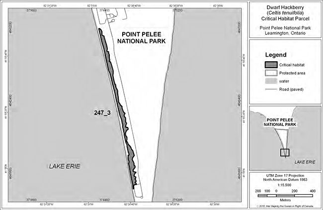
Enlarge Figure 4: Location and extent of critical habitat parcel #247_3 for Dwarf Hackberry
Note: The term "Protected Areas" used in the critical habitat maps has no relation to protection requirements under SARA.
Figure 5: Location and extent of critical habitat parcel #247_4 for Dwarf Hackberry. Critical habitat does notinclude existing infrastructure, existing cultivated areas, unnatural vegetation types, or areas in or adjacent to anthropogenic features where the presence of Dwarf Hackberry is opportunistically related to the existence of these features, as described in Section 7.1.
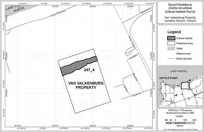
Enlarge Figure 5: Location and extent of critical habitat parcel #247_4 for Dwarf Hackberry
Figure 6: Area within which critical habitat for Dwarf Hackberry is found (critical habitat parcel #247_11). Pleaserefer to Section 7.1 for the description of biophysical attributes to help locate the critical habitat within this area. Critical habitat does not include existing infrastructure, existing cultivated areas, unnatural vegetationtypes, or areas in or adjacent to anthropogenic features where the presence of Dwarf Hackberry is opportunistically related to the existence of these features, as described in Section 7.1.
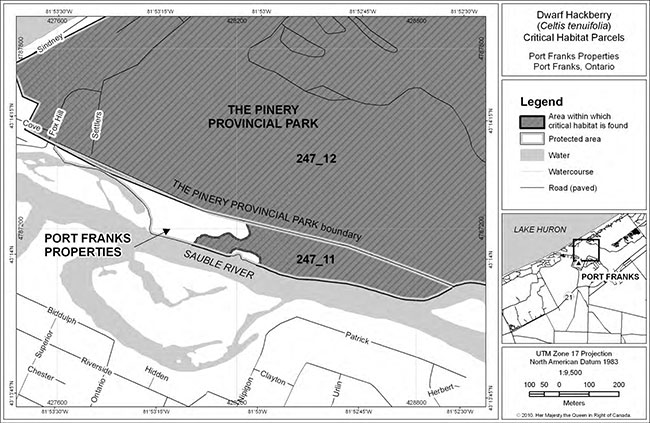
Figure 7: Location and extent of critical habitat parcel #247_20 for Dwarf Hackberry. Critical habitat does not include existing infrastructure, existing cultivated areas, unnatural vegetation types, or areas in or adjacent to anthropogenic features where the presence of Dwarf Hackberry is opportunistically related to the existence of these features, as described in Section 7.1.
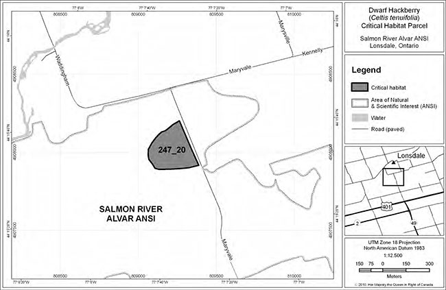
Enlarge Figure 7: Location and extent of critical habitat parcel #247_20 for Dwarf Hackberry
Figure 8: Location and extent of critical habitat parcel #247_13, #247_14, #247_15, and #247_17 and area within which critical habitat for Dwarf Hackberry is found (critical habitat parcel #247_16 – please refer to Section 7.1 for the description of biophysical attributes to help locate the critical habitat within this area). Critical habitat does not include existing infrastructure, existing cultivated areas, unnatural vegetation types, or areas in or adjacent to anthropogenic features where the presence of Dwarf Hackberry is opportunistically related to the existence of these features, as described in Section 7.1.
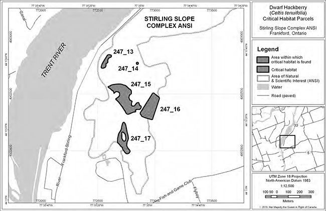
Figure 9: Location and extent of critical habitat parcel #247_10 for Dwarf Hackberry. Critical habitat does notinclude existing infrastructure, existing cultivated areas, unnatural vegetation types, or areas in or adjacent to anthropogenic features where the presence of Dwarf Hackberry is opportunistically related to theexistence of these features, as described in Section 7.1.
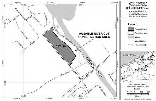
Enlarge Figure 9: Location and extent of critical habitat parcel #247_10 for Dwarf Hackberry
Figure 10: Area within which critical habitat for Dwarf Hackberry is found (critical habitat parcel #247_7 and #247_8 – please refer to Section 7.1 for the description of biophysical attributes to help locate the critical habitat within this area) and location and extent of critical habitat parcel #247_9 for DwarfHackberry. Critical habitat does not include existing infrastructure, existing cultivated areas, unnaturalvegetation types, or areas in or adjacent to anthropogenic features where the presence of DwarfHackberry is opportunistically related to the existence of these features, as described in Section 7.1.
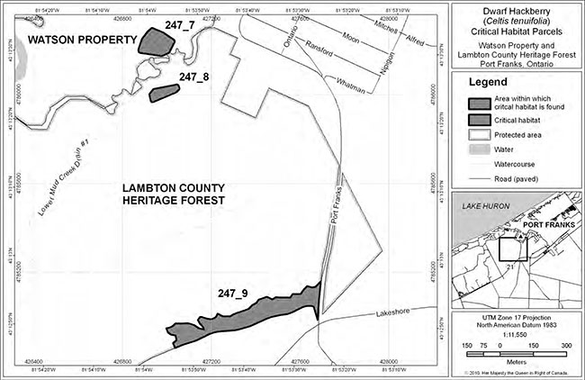
Figure 11: Area within which critical habitat for Dwarf Hackberry is found (critical habitat parcel #247_5 – please refer to Section 7.1 for the description of biophysical attributes to help locate the critical habitat within this area) and location and extent of critical habitat parcel #247_6 for Dwarf Hackberry. Critical habitat does not include existing infrastructure, existing cultivated areas, unnatural vegetation types, or areas in or adjacent to anthropogenic features where the presence of Dwarf Hackberry is opportunistically related to the existence of these features, as described in Section 7.1.
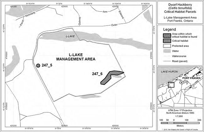
Figure 12: Area within which critical habitat for Dwarf Hackberry is found (critical habitat parcel #247_18 – please refer to Section 7.1 for the description of biophysical attributes to help locate the critical habitat within this area) and location and extent of critical habitat parcel #247_19 for Dwarf Hackberry. Critical habitat does not include existing infrastructure, existing cultivated areas, unnatural vegetation types, or areas in or adjacent to anthropogenic features where the presence of Dwarf Hackberry is opportunistically related to the existence of these features, as described in Section 7.1.
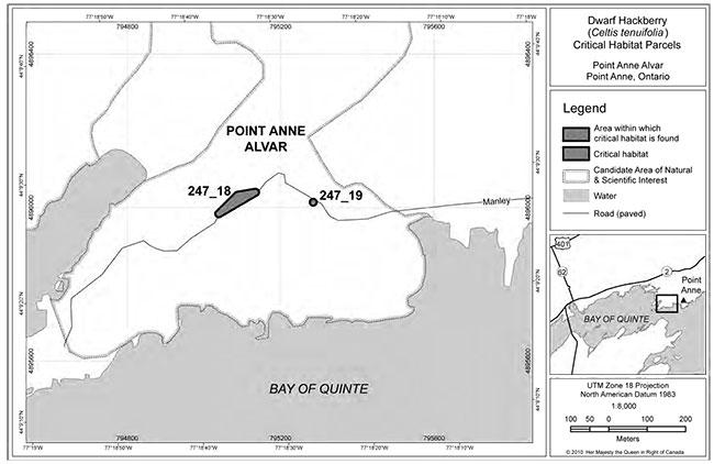
Figure 14: Area within which critical habitat for Dwarf Hackberry is found (critical habitat parcel #247_1 and#247_2). Please refer to Section 7.1 for the description of biophysical attributes to help locate the critical habitat within this area. Critical habitat does not include existing infrastructure, existing cultivated areas, unnatural vegetation types, or areas in or adjacent to anthropogenic features where the presence of Dwarf Hackberry is opportunistically related to the existence of these features, as described in Section 7.1.
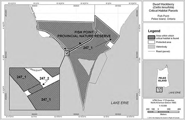
Figure 16: Area within which critical habitat for Dwarf Hackberry is found (critical habitat parcel #247_12). Please refer to Section 7.1 for the description of biophysical attributes to help locate the critical habitat within this area. Critical habitat does not include existing infrastructure, existing cultivated areas, unnatural vegetation types, or areas in or adjacent to anthropogenic features where the presence of Dwarf Hackberry is opportunistically related to the existence of these features, as described in Section 7.1.
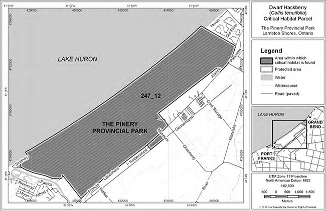
Footnotes
- footnote[1] Back to paragraph Deciduous trees shed their leaves each year.
- footnote[2] Back to paragraph Divaricate branches and twigs spread apart at a wide angle.
- footnote[3] Back to paragraph Hermaphroditic flowers have both male and female sexes borne on a single flower.
- footnote[4] Back to paragraph In the Great Lakes basin, "alvar" refers to naturally open areas with shallow soils over relatively flat, limestone bedrock, with trees absent or at least not forming a continuous canopy (Reschke et al. 1999, Brownell and Riley 2000).
- footnote[5] Back to paragraph Allelopathic plants suppress or inhibit the growth of other plants through the release of chemical toxins.
- footnote[6] Back to paragraph Competitive exclusion relates to two species competing for the same resources that cannot stably coexist if other ecological factors are constant. One of the two competitors will always overcome the other, leading to either the extinction of the weaker competitor or an evolutionary or behavioural shift towards a different ecological niche.
- footnote[7] Back to paragraph Niche differentiation is the process by which natural selection drives competing species into different patterns of resource use or different ecological niches, allowing two species to partition resources so that one species does not out-compete the other as dictated by the competitive exclusion principle. Coexistence is obtained through the differentiation of their realized or actual ecological niches. Resources may be partitioned though space or time.
- footnote[8] Back to paragraph Repatriation restores a species to a location where it was formerly found, but is no longer present.
- footnote[9] Back to paragraph Augmentation adds individuals of a species to an existing population in order to increase population size.
- footnote[10] Back to paragraph ELC is a land and resource classification system that describes and delineates ecosystem units based on ecological factors including vegetation, soil, and geological conditions (Lee et al. 1998).
- footnote[11] Back to paragraph Diameter at breast height is the diameter of a tree 1.3 m above ground level.
- footnote[12] Back to paragraph A minimum convex polygon is the smallest shape, drawn with straight line segments, which will surround all straight line segments that can be drawn between the outside edges of the tree root zones of two trees within a Dwarf Hackberry population. As an analogy, picture an elastic stretched around a group of pegs on a peg board.
- footnote[13] Back to paragraph A seral stage is an intermediate phase during ecological succession of an ecosystem as it advances toward its climax community.