East Bay Conservation Reserve Management Statement
This document provides policy direction for the protection, development and management of the East Bay Conservation Reserve and its resources.
Statement of Conservation Interest
Ministry of Natural Resources
Lakehead Area
Thunder Bay District
November 2001
Shaun Walker
Resource Manager
Approval statement
I am pleased to approve this Statement of Conservation Interest for the East Bay Conservation Reserve.
This Statement of Conservation Interest will provide guidance for the management of the conservation reserve and the basis for the ongoing monitoring of activities. More detailed direction at this time is not anticipated. Should significant facility development be considered or complex issues arise requiring additional studies, more defined management direction, or special protection measures, a more detailed Conservation Reserve Management Plan will be prepared with full public consultation.
The public was widely consulted during the regulation process for this conservation reserve and further consultation is not required at this time.
The conservation reserve will be managed under the jurisdiction of the Lakehead Area Supervisor, Thunder Bay District, Ministry of Natural Resources.
Signed by:
Bill Baker
District Manager
Thunder Bay District
Date: July 12, 2002
Signed by:
Ralph Wheeler
A/Regional Director
Northwest Region
Date: July 15, 2002
1.0 Background information
The East Bay Conservation Reserve is comprised of approximately 1,893 hectares of Crown land along the southern shoreline of Dog Lake’s eastern arm, roughly 35 kilometres north of the City of Thunder Bay. The area’s northern boundary consists of the water’s edge of Dog Lake, East Bay and Walberg Bay. The area’s west, south and east boundaries consist for the most part of straight lines between coordinate points.
| Name | East Bay Conservation Reserve (C2265) |
|---|---|
| Site Region / Site District | 3W / 3W-2 |
| OMNR Administrative Region – District – Area | Northwest Region – Thunder Bay District – Lakehead Area |
| Total Area (ha) | 1893 |
| Regulation Date | - |
| First Nations | Fort William First Nation |
| Ontario Base Map | 16 3200 54000 |
| Latitude / Longitude | 48°45' / 89°23' |
| Basemap | 20 16 32540 |
| Forest Resource Inventory Stands | See Appendix E for stand #'s and descriptions. |
| General Location Description | The East Bay Conservation Reserve is located roughly 35 kilometres north of the City of Thunder Bay, along the southern shoreline of Dog Lake’s eastern arm. |
| Access | The conservation reserve can be accessed directly from highway #589 or by boat via Dog Lake. |
1.1 Targets
| Earth Science Representation | Originally classified and nominated on the basis of representing relatively undisturbed, mature deciduous-dominated mixedwood forests on strongly broken ground moraine. This was however incorrect as the site has since been found to be dominated by moderately to strongly broken bedrock with thin morainal veneers. The area exhibits undulating to hummocky, and ridged to knobbed bedrock overlain by thin (and often discontinuous) morainal and lacustrine materials. |
|---|---|
| Life Science Representation | 1. Upland Forest: The site provides a good example of mature, deciduous-dominated mixedwood forest. Species include trembling aspen, white birch and black spruce with occasional occurrences of jack pine, balsam fir, and tamarack. Vegetation Types include V9 – Trembling Aspen Mixedwood, V4 – White Birch Hardwood and Mixedwood, V34 – Black Spruce / Labrador Tea / Feathermoss (Sphagnum), and Vegetation Type V33 – Black Spruce / Feathermoss. 2. Wetlands: Small open and treed wetland sites with thick organic deposits occur in depressions and bordering small lakes and shoreline areas, as well as along fluvial channels. Species include scattered, stunted black spruce and tamarack and the occasional white Vegetation types include V34 – Black Spruce / Labrador Tea / Feathermoss (Sphagnum), and Vegetation Type V33 – Black Spruce / Feathermoss. |
| Cultural Resources Representation | None identified at this time. ammended |
| Recreational Opportunities | Opportunities exist for hunting, wildlife viewing, hiking, snowshoeing, snowmobiling and ATV use. The site also offers access to sport fishing and other water based recreational opportunities on the adjacent Dog Lake. |
| Survey Level | Earth Science | Life Science | Cultural | Recreational | Other |
|---|---|---|---|---|---|
| Reconnaissance | Completed Fall 2000 | Completed Fall 2000 | - | Completed Fall 2001 | - |
| Detailed | Required only before any additional recreational facilities are constructed | Required only before any additional recreational facilities are constructed | Required only before any additional recreational facilities are constructed | Required only to assess the demand for additional recreational facilities | - |
2.0 Values to be protected
The East Bay Conservation Reserve is comprised of a diversity of upland forest and wetland vegetation types on a variety of landform types including ridged to knobbed bedrock overlain by thin (often discontinuous) morainal and lacustrine materials, as well as areas dominated by thicker morainal and glaciofluvial (outwash) deposits.
Vegetation cover within the site is characteristic of the surrounding area and is predominantly fire-origin, mature mixedwood forest. Aspect, soil thickness and soil drainage all tend to influence forest species composition, with coniferous-dominated stands being more prevalent on north aspects and poorer drained depressional areas as well as along lakeshore fringes. Deciduous-dominated stands occur more commonly on southerly aspects and plateau uplands.
Forest stands tend to be fairly mature throughout the site, with few younger age classes represented. Deciduous stands and deciduous-dominated mixedwood stands are generally comprised primarily of either trembling aspen or white birch. Patches of feathermoss exist throughout the site, however moss cover is generally low.
The diversity of vegetation and forest cover types provide an equally diverse assemblage of wildlife habitats. Deciduous-dominated mixedwood stands provide excellent moose forage opportunities, while coniferous-dominated mixedwood and pure coniferous stands afford thermal habitats. The presence of ericaceous shrubs in the understory of mixedwood forest components also provides good habitat for black bears and smaller furbearers. OMNR records indicate that one registered trapline traverses the East Bay Conservation Reserve, on which beaver and fisher were the reported catches. Browsing (by moose) was evident on aspen and birch trees and on alder and maple in the tall shrub layers.
The intent of this Statement is to protect these values by establishing management guidelines for existing and potential uses in this conservation reserve given the level of past disturbances and the nature of existing features.
3.0 Management guidelines
3.1 Land tenure
The East Bay Conservation Reserve consists entirely of Crown land. Patented lands associated with several water access cottage lots and a commercial tourism operation have all been removed from the conservation reserve. Several land use permits (LUP's) exist within the boundaries of this conservation reserve. These permits have been issued for a range of purposes including recreational use, gate locations, a boat launch and a waste disposal site. The LUP for recreational use was deemed to be a compatible use and was therefore not removed from the conservation reserve. Likewise it was determined that the two LUP's issued for gate locations would not significantly impact either the conservation reserve’s features nor any individual’s use and/or enjoyment of those features, and so they too remain as part of the conservation reserve. The regulation of this conservation reserve will not have any effect on the re-issuance of these LUP's. Landfilling and waste disposal activities associated with the LUP issued for these purposes were, however, deemed to be conflicting uses and therefore the area affected by these activities was removed from the conservation reserve. This area will be monitored to ensure that Conservation Reserve values are not being negatively impacted by the continued operation of this waste disposal site.
Sale of lands is not permitted, except for minor dispositions in support of existing uses (e.g., reconstruction of a septic system). The renewal of existing land use permits will be permitted. New leases or land use permits permitted for approved activities. Tourism facilities may apply to upgrade tenure from land use permit to lease. Private recreation camps will not be permitted.
Water levels on Dog Lake are currently subject to fluctuation due to the operation of the Silver Falls generating station.
New transmission lines, pipelines, highways, and road corridors will be discouraged. Expansion of road or utility line right-of-ways may be permitted to meet essential public service needs. Before disposing of conservation lands for these purposes, the Ministry of Natural Resources will work closely with the proponent to ensure that all reasonable alternatives have been considered and that impacts on heritage values are minimized. Industrial uses such as mining, hydroelectric development, and extraction of aggregates, peat, soils, and other similar materials will not be permitted.
Any unauthorized occupations of lands within the conservation reserve will be managed in accordance with approved policy.
3.2 Existing / proposed development
The road system within the East Bay conservation reserve consists of one main road (the Dog Lake Road - an extension of Highway #589), an old logging road and several short trails. The use of these existing roads and trails will be allowed to continue. This continued use will include maintenance and may include future upgrading. Development of trails for a variety of activities (i.e., hiking, cycling, horseback riding, snowmobiling) can be considered as part of a planning process. New roads for resource extraction will not be permitted.
New development such as campsites, parking lots, and privies will not be considered unless a demand for such recreation facilities becomes apparent; more detailed earth and life science information is collected; and a more detailed management plan is prepared.
3.3 Recreation activities
Recreational uses such as hunting, fishing, camping, hiking, wildlife viewing and snowshoeing will be allowed to continue within the Conservation Reserve.
Mechanized travel is permitted only on existing roads and trails with the exception that ATV's and snowmobiles may also be used for the direct retrieval of game. New trails may be considered where compatible with other recreational uses and the environmental values being protected.
3.4 Commercial activities
The conservation reserve forms part of an active trapline and three Bait Fish Harvest Areas. These uses will continue to be permitted with the condition that no new trails or other development will be allowed without specific authorization. New baitfish and commercial fur harvest operations can be considered subject to the ‘test of compatibility'. There are currently no trap cabins within the Conservation Reserve, and no new ones will be permitted.
The site also falls within an active Bear Management Area. Existing baitfish and BMA licenses that become vacant may be re-issued, and will be considered on a case-by-case basis. New BMA's will not be permitted.
Timber harvesting, mining, aggregate extraction and commercial hydroelectric development will not be permitted.
The Dog Lake Resort commercial tourism operation and its associated patented lands have been excluded from the conservation reserve. New tourism facilities, outfitting services, outpost camps and resorts/lodges can be considered as part of a planning process.
The conservation reserve area will be removed from the licence area of the Black Sturgeon Forest.
3.5 Aboriginal interests
Any specific aboriginal values or interests within the conservation reserve remain unidentified at this time. Aboriginal and treaty rights will continue to be respected.
3.6 Natural resource stewardship
3.6.1 Vegetation management
Conservation Reserve policy indicates that Featured Species Management and Natural Systems Management may be permitted. Vegetation management can be considered in a planning process.
Forest fire suppression policies will be similar to adjacent Crown lands, unless alternative fire policies have been developed through a planning process.
Vegetation control will be permitted where necessary for public utilities and rights-of-way. Existing personal use permits for wood harvesting may continue on an interim basis for patent properties that do not have road access. The long term continuation will be determined through management planning.
The control of insects and diseases will be addressed on a case-by-case basis.
3.6.2 Fisheries and wildlife management
Fish and wildlife within the conservation reserve will continue to be managed in accordance with policies and regulations prevailing in the area. Conservation Reserves policy indicates that "featured species management" may be permitted. Sport fishing and hunting will continue as permitted uses within the conservation reserve.
3.6.3 Landforms
The landforms represented within this Conservation Reserve will not be altered through any landform modification activities such as trail development. The extraction of aggregates, peat, soils or any other similar materials will not be permitted.
3.7 Cultural resources stewardship
Any culturally significant sites within the conservation reserve remain unidentified at this time. The Ministry of Natural Resources will continue to work with the Ministry of Tourism, Culture and Recreation in identifying archaeological sites that should be protected.
3.8 Client services
Thunder Bay District and the Information Management staff will be the primary contact for responding to inquiries about the basic level of information such as boundary locations, access, permitted uses, natural heritage appreciation and wildlife viewing opportunities.
3.9 Research
Scientific research by qualified individuals that will contribute to the knowledge of natural and cultural history and to environmental and recreational management, will be encouraged.
All research programs will require the approval of the Ministry of Natural Resources and will be subject to ministry policy and other legislation. The ministry may approve the removal of any natural or cultural specimen by qualified researchers. All such materials removed remain the property of the Ministry of Natural Resources.
Approved research activities and facilities will be compatible with the protection objectives. Permanent plots or observation stations may be established to which researchers can return over time. Any site that is disturbed will be rehabilitated as closely as possible to its original state.
3.10 Marketing
Marketing efforts to increase use are not a priority and will be kept to a minimum. A fact sheet has been produced and is readily available to the public via either the Internet or through contact with the Thunder Bay District office.
4.0 Implementation
Implementation of this Statement of Conservation Interest will primarily involve monitoring activities to ensure adherence to the management guidelines. Implementation of this Statement and management of the conservation reserve are the responsibility of the Lakehead Area Supervisor.
5.0 Review and revisions
The East Bay Conservation Reserve Statement of Conservation Interest will be reviewed on an ongoing basis. If changes in management direction are required at any time, the significance of those changes will be evaluated. Minor changes that do not alter the overall protection objectives may be considered and approved by the area supervisor without further public consultation and the Statement of Conservation Interest would be amended accordingly. In assessing major changes, the need for a more detailed Conservation Management Plan will first be considered. Where a management plan is not considered necessary or feasible, a major amendment may be considered with public consultation. Major amendments will require approval by the Regional Director.
6.0 Public consultation
6.1 Results of past consultation
Consultation on the proposed East Bay Conservation Reserve was conducted as part of the consultation associated with the Ontario’s Living Legacy Land Use Strategy from 1997 through to 1999. Subsequent consultation for the purpose of boundary refinement was held from June 15 - July 15, 2001.
Consultation efforts involved the mailing of District Manager letters and information packages to adjacent landowners, local First Nations, forest industry (SFL holder), the Local Citizens Committee, local trappers, Bear Management Area and Baitfish license holders as well as the Northern Ontario Sportsman’s Alliance and any other affected or interested parties. Newspaper advertisements were placed in Thunder Bay’s Chronicle Journal as well as the Thunder Bay Post.
One comment was received concerning the impact of the Conservation Reserve designation on the surrounding, adjacent private landowners in terms of permitted uses within the area.
Aboriginal consultation has consisted of a pre-consultation letter sent June 16, 2000. A formal letter of consultation followed in August 2000. On November 20, 2000 the District Manager, Area Supervisor and Acting Information Management Supervisor met with the Fort William First Nation Chief, Band Manager and Land Claim representative. Subsequent meetings were scheduled for August 16th and 17th, September 10th and 12th and October 9th, 2001. All were cancelled.
6.2 Present and future consultation
An additional attempt will be made to consult with the Fort William First Nation. If it fails MNR may choose to proceed with the regulation of the Conservation Reserve. Fort William First Nation will be advised of this decision and will be offered an invitation to participate in any future management decisions.
7.0 References
Geowest Environmental Consultants Ltd. Earth and Life Science Reconnaissance Surveys. 2000.
Ontario Ministry of Natural Resources, Conservation Reserve’s Policy and Procedure. PL 3.03.05. 1997.
Ontario Ministry of Natural Resources, East Bay Conservation Reserve Fact Sheet. Thunder Bay District. 2001.
Ontario Ministry of Natural Resources, Ontario’s Living Legacy Land Use Strategy. Queen’s Printer for Ontario, Ontario, Canada, 1999.
Figure 1. Site Map
Enlarge site map of East Bay Conservation Reserve
Appendix A
East Bay Conservation Reserve permitted uses table
Policy Report (revised August 23, 2001)
Identification:
| New ID: | C2265/TB11 |
|---|---|
| District: | Thunder Bay |
| Region: | Northwest |
| ID: | C2265 |
| Area Name: | East Bay |
| Area (ha): | 1551 |
| Land Use: | Conservation Reserve |
| Category: |
Description:
This site contains a representative upland forest around the access area to the east arm of Dog Lake.
Land use intent:
The intent is to regulate this area as a Conservation Reserve. Management of this area is also governed by the general policies contained in the Land Use Strategy (1999).
Management direction:
Those uses and management activities not listed in the following table are governed by existing Conservation Reserve policy. Over time the management direction will be elaborated in a Statement of Conservation Interest or Resource Management Plan. Any new uses, and commercial activities associated with them, will be considered on a case by case basis, and they must pass a test of compatibility to be acceptable. Compatibility is normally determined through a planning process.
Commercial activities:
| Activity | Permitted | Guidelines |
|---|---|---|
| Aggregate extration | No | |
| Bait fishing - Existing | Yes | Existing use permitted to continue, unless there are significant demonstrated conflicts. |
| Bait fishing - New | Maybe | New operations can be considered, subject to the "test of compatibility". |
| Commercial fishing - Existing | No | |
| Commercial fishing - New | No | |
| Commercial fur harvesting - Existing | Yes | Existing use permitted to continue, unless there are significant demonstrated conflicts. |
| Commercial fur harvesting - New | Maybe | New operations, including associated trails, can be considered, subject to the "test of compatibility". New trap cabins are not permitted. |
| Commercial hydro development | No | |
| Commercial timber harvest | No | |
| Commercial tourism - Existing | Yes | Existing authorized facilities can continue, unless there are significant demonstrated conflicts. |
| Commercial tourism - New | Maybe | New tourism facilities can be considered as part of a planning process. |
| Bear hunting by non-residents (guided) - Existing | Yes | Existing authorized operations permitted to continue. |
| Bear hunting by non-residents (guided) - New | No | New operations not permitted. |
| Outfitting services - Existing | Yes | Existing authorized operations permitted to continue. |
| Outfitting services - New | Maybe | New operations can be considered as part of a planning process. |
| Outpost camps - Existing | No | |
| Outpost camps - New | Maybe |
New operations can be considered as part of a planning process. |
| Resorts/lodges - Existing | Yes | Existing authorized facilities permitted to continue. |
| Resorts/lodges - New | Maybe | New facilities can be considered as part of a planning process. |
| Energy transmission and communications cooridors - Existing | Yes |
These facilities should avoid conservation reserve lands wherever possible. |
| Energy transmission and communications cooridors - New | No |
These facilities should avoid conservation reserve lands wherever possible. |
| Food harvesting (commercial) - Existing | Maybe | |
| Food harvesting (commercial) - New | Maybe | |
| Mineral exploration and development | No | |
| Peat extraction | No | |
| Wild rice harvesting - Existing | Yes | |
| Wild rice harvesting - New | Maybe |
Land and resource management activities:
| Activity | Permitted | Guidelines |
|---|---|---|
| Crown land disposition private use | Maybe | Sale of lands is not permitted, except for minor dispositions in support of existing uses (e.g., reconstruction of a septic system). Renewals of existing leases and land use permits are permitted. New leases or land use permits permitted for approved activities. Tourism facilities can apply to upgrade tenure from LUP to lease. |
| Crown land disposition commercial use | Maybe | Sale of lands is not permitted, except for minor dispositions in support of existing uses (e.g., reconstruction of a septic system). Renewals of existing leases and land use permits are permitted. New leases or land use permits permitted for approved activities. Tourism facilities can apply to upgrade tenure from LUP to lease. |
| Fire suppression | Yes | Fire suppression policies are similar to adjacent Crown lands, unless alternative fire policies have been developed through a planning process. |
| Fish habitat management | Maybe | |
| Fish stocking native species | Maybe | Conservation Reserves policy indicates that "featured species management" may be permitted. No explicit guidelines are included on fish stocking. |
| Fish stocking Non-native species | No | Conservation Reserves policy indicates that "featured species management" may be permitted. No explicit guidelines are included on fish stocking. |
| Insect / disease suppression | Maybe | Control of insects and diseases will be addressed on a case-by-case basis. |
| Inventory / monitoring | Yes | |
| Personal use permits for wood harvesting | Maybe | Existing permits may continue on an interim basis for properties that do not have road access. The long term status will be determined through management planning. |
| Prescribed burning | No | |
| Roads (resource access) - Existing | Yes | Existing roads can continue to be used. Continued use will include maintenance and may include future upgrading. |
| Roads (resource access) - New | No | New roads for resource extraction will not be permitted. |
| Vegetation management | Maybe | Conservation Reserves policy indicates that Featured Species Management and Natural Systems Management may be permitted. Vegetation management can be considered in a planning process. |
| Wildlife management | No |
Science, education and heritage appreciation:
| Activity | Permitted | Guidelines |
|---|---|---|
| Collecting | No | |
| Historial appreciation | Yes | |
| Nature appreciation | Yes | |
| Photography and painting | Yes | |
| Research | Yes | |
| Wildlife viewing | Yes |
Recreation activities and facilitation:
| Activity | Permitted | Guidelines |
|---|---|---|
| All-terrain vehicle use On trails | Yes | Existing use permitted to continue where it does not adversely affect the values being protected. |
| All-terrain vehicle use Off trails | No | ATV use off trails is not permitted except for direct retrieval of game. |
| Campgrounds | Maybe | |
| Food gathering | Yes | |
| Horseback riding (trail) | Yes | Existing use on trails permitted. |
| Hunting | Yes | |
| Mountain bike use | Yes | Existing use on trails permitted. |
| Motor boat use Commercial | Yes | |
| Motor boat use Private | Yes | |
| Non-motorized recreation travel | Yes | |
| Private recreation camps (hunt camps) - Existing | No | |
| Private recreation camps (hunt camps) - New | No | |
| Rock climbing | Maybe | |
| Snowmobiling on trails | Yes | Existing use permitted to continue where it does not adversely affect the values being protected. |
| Snowmobiling off trails | Maybe | Snowmobile use off trails is not permitted except for direct retrieval of game. |
| Sport fishing | Yes | |
| Trail development | Maybe | Development of trails for a variety of activities (e.g., hiking, cross-country skiing, cycling, horseback riding, snowmobiling) can be considered as part of a planning process. |
Note: The policies outlined in this table do not supersede any Aboriginal or treaty rights that may exist, or other legal obligations.
Source: OLL Land Use Strategy, Table 4, and Conservation Reserve Policy.
Management of this Conservation Reserve is carried out within the context of conservation reserve policy as amended by the policies for new conservation reserves outlined in the OLL Land Use Strategy.
Source of Direction: Land Use Strategy
Explanation of Edits:
Potential Revisions (for internal use only):
Appendix B
East Bay Conservation Reserve
Recreation Inventory Report
East Bay Conservation Reserve (C2265)
Recreation Inventory Report
November 2001
Ontario Ministry of Natural Resources
Northwest Region
Prepared By: Shaun Walker
Thunder Bay District, 2001
1.0 Introduction
This report constitutes a summary of background information and fieldwork pertaining to the recreational resource inventory conducted for the East Bay Conservation Reserve. This report is intended for internal use as background information for future planning and management decisions regarding the East Bay Conservation Reserve.
The East Bay Conservation Reserve is located approximately 40 kilometers north of Thunder Bay. The site is approximately 1893 hectares in size and can be accessed from secondary Highway 589.
A recreational resource assessment was conducted for the conservation reserve in order to determine:
- the most significant biophysical features which support recreation
- the existing and potential recreational uses of the conservation reserve
- the environmental impacts associated with recreational use
- the variety of human influences and land uses in the conservation reserve
2.0 Map overview
Enlarge map overview of East Bay Conservation Reserve
3.0 Description of the study area
3.1 General setting:
The East Bay Conservation Reserve is located along the southern shoreline of the eastern arm of Dog Lake and is composed of approximately 1893 hectares of Crown land around the access area to this east arm. The area’s northern boundary consists of the water’s edge of Dog Lake, East Bay and Walberg Bay. The sites West, South and East boundaries consist for the most part of straight lines between coordinate points. The conservation reserve can be accessed directly from highway # 589 or by boat via Dog Lake.
3.2 Cultural values
Aside from the area’s proximity to major settlements, little is known about the cultural values of the conservation reserve. To date, there has been no formal documentation of cultural values within or adjacent to the proposed conservation reserve.
3.3 Life science values
Geowest Environmental Consultants Ltd. conducted a reconnaissance life science inventory for this conservation reserve in the fall of 2000. The following represents a brief summation of their findings. To obtain more detailed information on these life science values the original checksheet should be consulted.
The East Bay Conservation Reserve is comprised of a diversity of upland forest and wetland vegetation types on a variety of landform types including ridged to knobbed bedrock overlain by thin (often discontinuous) morainal and lacustrine materials, as well as areas dominated by thicker morainal and glaciofluvial (outwash) deposits.
Vegetation cover within the site is characteristic of the surrounding area and is predominantly fire-origin, mature mixedwood forest. Aspect, soil thickness and soil drainage all tend to influence forest species composition, with coniferous-dominated stands being more prevalent on north aspects and poorer drained depressional areas and along lakeshore fringes. Deciduous-dominated stands occur more commonly on southerly aspects and plateau uplands.
Forest stands tend to be fairly mature throughout the site, with few younger age classes represented. Deciduous stands and deciduous-dominated mixedwood stands are generally comprised primarily of either trembling aspen or white birch. Patches of feathermoss exist throughout the site, however moss cover is generally low.
The East Bay Conservation Reserve is drained by a number of small, permanent and ephemeral, unnamed creeks that flow northward into the East Bay of Dog Lake. Several small, unnamed lakes occur along the southern boundary of the site. Dog Lake is drained by the Kaministiquia River, which flows south into Lake Superior. Water levels on Dog Lake are currently subject to fluctuation due to the operation of the Silver Falls generating station. Dog Lake is a relatively deep, cool water lake home to walleye, northern pike and lake whitefish. These characteristics have made it a locally popular sport fishing lake.
The conservation reserve area is relatively undisturbed except for the road right-of-way accessing the Dog Lake Resort at the south end of Walberg Bay. Areas of disturbance excluded from the Conservation Reserve include the Dog Lake Resort, a small landfill site south of the Dog Lake Resort, and a small area of cottage development along the northwest shore of Walberg Bay.
The diversity of vegetation and forest cover types provide an equally diverse assemblage of wildlife habitats. Deciduous-dominated mixedwood stands provide excellent moose forage opportunities, while coniferous-dominated mixedwood and pure coniferous stands afford thermal habitats. The presence of ericaceous shrubs in the understory of mixedwood forest components also provides good habitat for black bears and smaller furbearers. OMNR records indicate that one registered trapline traverses the East Bay Conservation Reserve, on which beaver and fisher were the reported catches. Browsing (by moose) was evident on aspen and birch trees and on alder and maple in the tall shrub layers.
3.4 Earth science values
Geowest Environmental Consultants Ltd. conducted a reconnaissance earth science inventory for this conservation reserve in the fall of 2000. The following represents a brief summation of their findings. To obtain more detailed information on these earth science values the original checksheet should be consulted.
The East Bay Conservation Reserve provides examples of topography associated with the Late Wisconsian period (surficial materials) and the Late Archean Volcanic Islands/Sedimentary Basin (bedrock). The reserve exhibits topography, bedrock and surficial materials and distribution typical to a shield terrain in this part of Ontario. These features are well represented in other parks and conservation reserves, and should be considered to have local significance.
4.0 Methodology
Information for this recreational inventory report was gathered from aerial photographs, maps, earth and life science reports (completed by Geowest Environmental Consultants Ltd.), area reports (values information, Forest Resource Inventory, fisheries information) as well as two site visits and several discussions with MNR District staff. Site visits were conducted in late summer and early fall of 2001.
5.0 Recreational features
Recreation features are biophysical or cultural attributes that may be able to support recreational activity. A total of three features were recorded and ranked according to their recreational value and importance on the Recreation Inventory Checklist. Features were selected from a list of known recreation features as outlined in the Ontario’s Living Legacy Guidelines for Recreation Resource Assessment, Version 2 – April, 2001. Each feature listed had a corresponding code. The following three sections provide more detail on each of these features.
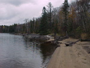
5.1 Sandy beaches (B17)
As depicted in the accompanying map, the East Bay Conservation Reserve includes several sandy beaches. These beaches are among some of the areas nicest, with one of them being frequently used by both tourists and locals in search of a variety of recreational pursuits. Sport fishermen on Dog Lake commonly use each of these beaches as shore lunch sites.
5.2 Wildlife - general (W00)
The diversity of vegetation and forest cover types provide an equally diverse assemblage of wildlife habitats. Deciduous-dominated mixedwood stands provide excellent moose forage opportunities, while coniferous-dominated mixedwood and pure coniferous stands afford thermal habitats. The presence of ericaceous shrubs in the understory of the mixedwood forest components also provides good habitat for black bear and smaller furbearers. Browsing (by moose) was evident on aspen and birch trees and on alder and maple in the tall shrub layers. The interspersion and juxtaposition of security, thermal, and foraging habitats for ungulates and furbearers is a key feature of this site. In addition, breeding bird diversity can be expected to be relatively high due to the diversity of habitats present.
5.3 Waterbodies - general (M00)
The Conservation Reserve is comprised of approximately 1893 ha of crown land around the access point to the East Bay of Dog Lake. Although this conservation reserve does not actually include any portion of Dog Lake, it was thought that because it secures such a large area of crown land around one of the access points to this lake, many of the potential users would be interested in the general water sport opportunities that this adjacent lake provides.
6.0 Recreational activities
Recreation activities are closely related to recreation features, although there is not necessarily a direct correlation, as one feature may have the potential to support a wide variety of recreational activities. During the recreation inventory, six activities were recorded and ranked on the Recreation Inventory Checklist. Activities were selected from a list of known recreation activities as outlined in the Ontario’s Living Legacy Guidelines for Recreation Resource Assessment, Version 2 – April, 2001.
Each activity listed below has a corresponding code. Existing activities were differentiated from potential activities by using a capital letter in their activity code. The following six sections provide more detail on each of these features and have been organized by their rankings, and listed by activity and activity code.
6.1 Beach activities - (K01)
The East Bay conservation reserve includes several sandy beaches that are currently receiving a moderate degree of recreational use. This existing use includes camping, shore lunch sites and swimming. Evidence of these uses exists on several beaches in the form of fire pits, constructed tables and cleared vegetation. These beaches will most likely receive the majority of recreational use within the entire conservation reserve.
6.2 Hunting - general (H00)
The East Bay Conservation Reserve provides hunting opportunities for large game, upland game (grouse), and migratory birds. Site visits revealed evidence, in the form of spent shotshell casings, of both waterfowl and upland game hunting. Discussions with the owners of the ‘Dog Lake Resort' revealed that the area is also frequently used by moose and bear hunters during the designated fall seasons.
6.3 Nature Activities – general (n00)
The East Bay conservation reserve provides opportunities for hiking, wildlife viewing and nature interpretation/appreciation. The site’s approximate 1.5 kilometre logging trail provides a suitable route for hiking and snow-shoeing and leads to a small cut-over ideal for berry picking in the summer months as well as wildlife viewing.
6.4 Camping – general (K00)
There are presently no formal backcountry campsites, however site visits revealed evidence of lakeside camping in the form of fire pits, constructed tables and vegetation clearing at the end of an existing trail as well as several sites along the southern shoreline of East Bay.
6.5 Watersports – general (B00)
The Conservation Reserve consists of approximately 1893 ha of crown land around the access point to the East Bay of Dog Lake. While no portion of Dog Lake is actually located within the conservation reserve, the access and many sandy beaches and shore lunch sites that the area provides are quite beneficial to individuals participating in various water based recreational pursuits such as sport fishing, swimming, boating and water-skiing.
6.6 Trapping (H06)
OMNR records indicate that one registered trapline traverses the East Bay Conservation Reserve, on which beaver and fisher were the reported catches.
6.7 Traveling – general (t00)
While the Conservation Reserve’s logging road is relatively short (approximately 1.5 kilometres) it does provide some potential opportunity for ATV and snowmobile use.
Mechanized travel will be permitted only on existing roads and trails with the exception that ATV's and snowmobiles may also be used for the direct retrieval of game.
7.0 Recreational factors
Recreational factors provide a context for the information collected during the recreation inventory, as they are meant to provide some insight on how the site will contribute to outdoor recreation at the regional level.
7.1 Feature significance
Feature significance is in effect a summary of feature scarcity and uniqueness, activity attraction capability, scenic attractiveness, and geographic significance. A rating of moderate is given for this area’s feature significance. This designation is primarily due to the fact that the majority of recreational features located within this conservation reserve can also be found in abundance throughout the surrounding area as well as in other local protected areas. An explanation of each of the factors contributing to this rating is provided below.
An evaluation of the recreation features described above concluded that the site’s sandy beaches represent the area’s scarcest feature. Each of the other features can be found in abundance throughout the surrounding area. While these sandy beaches did constitute the conservation reserve’s most scarce feature they should not be considered extremely rare or scarce. Similar features can be found on surrounding crown land (especially in times of draw down or periods of low water levels) and within other local protected areas such as the Silver Falls Provincial Park.
These sand beaches were also deemed to be the most unique feature within the site. This designation was once again due to the fact that each of the other features can be found in abundance throughout adjacent areas.
While this conservation reserve’s sandy beaches greatly enhance it’s scenic attractiveness and geographic significance, these factors were ranked as moderate due to the fact that this feature is also quite well represented in other local crown land and protected areas, including the Silver Falls Provincial Park. It was deemed unlikely that this area would receive more visitors than other similar Crown land or protected areas located within the region. The area will most likely continue to be used primarily by local residents in search of relatively solitary recreational experiences.
The East Bay Conservation Reserve’s activity attraction capability was also ranked as moderate. While the area does offer its users a wide variety of recreational experiences, a ranking of moderate was assigned primarily due to the fact that each of these experiences are also available locally on other crown land and protected areas. In addition, access to the site’s most unique features, the sand beaches, can really only be gained by water and since the conservation reserve does not have a public boat launch onto Dog Lake, the attraction capability of even these most unique features is somewhat limited. It should be noted that the adjacent Dog Lake Resort derives a great deal of business from the access they offer to Dog Lake.
7.2 Feature sensitivity to recreational use
Given this area’s limited access, the availability of its recreational features and the type of activities currently and/or potentially taking place within the area, it was not felt that any of the Conservation Reserve’s recreational features were at any significant risk from recreational use.
7.3 Feature sensitivity to resource development
It has been deemed unlikely that this Conservation Reserve will experience any increased use above that of other similar crown land or protected areas and subsequently the demand for any future resource development will most likely be rather minimal. After considering the area’s limited access, the widespread availability of its recreational features and the type of activities currently and/or potentially taking place within the area, it was not felt that any of the Conservation Reserve’s recreational features are at any significant risk from resource development.
7.4 Cultural / historic and archeological features
Aside from the area’s proximity to major settlements, little is known about the cultural values of the conservation reserve. To date, there has been no formal documentation of cultural values within or adjacent to the conservation reserve.
8.0 Recommendations
9.1 Additional research
Field visits should be made during the winter months to confirm and document additional recreational activities within the Conservation Reserve, keeping in mind that this winter recreation is most likely not lake related as the large winter draw down of Dog Lake creates un-safe ice conditions.
9.2 Future management
Management direction for this Conservation Reserve is provided by the Statement of Conservation Interest, which was prepared by Shaun Walker in November of 2001.
9.0 References
Geowest Environmental Consultants Ltd. Earth and Life Science Inventory Reports. Edmonton, Alberta. March, 2001.
Mulrooney, Dan. Ontario’s Living Legacy Guidelines for Recreation Resource Assessment, Version 2 – April 2001. Ontario Parks, September 2000.
Ontario Ministry of Natural Resources, East Bay Conservation Reserve Fact Sheet. Thunder Bay District. 2001.
Ontario Ministry of Natural Resources, Ontario’s Living Legacy Land Use Strategy. Queen’s Printer for Ontario, Ontario, Canada, 1999.
Appendix C
East Bay Conservation Reserve
Life Science Checklist
(Geowest Environmental Consultants Ltd. 2000)
Natural Heritage area - life science checklist
| Name: | East Bay Conservation Reserve (C2265) |
|---|---|
| Map Name: | Onion Lake East Bay |
| NTS No.: | 52A11 52A14 |
| UTM Reference: | 5404000N 324000E |
| County: | District of Thunder Bay |
| Latitude/Longitude: | 48°46'/89°25' |
| NAD: | 27 |
| Elevation (Min): | 430 m |
| Elevation (Max): | 520 m |
| Locality: | Dog Lake |
| Township: | N/A |
| Area: | 1551 ha |
| Ownership: | Crown |
| MNR Region: | Northwest |
| Ecoregion and Ecodistrict: | 3W-2 |
| Landform Unit(s): | Weakly to Strongly Broken Bedrock |
| MNR District: | Thunder Bay |
| Aerial Photographs: | Year-Roll-Flight Line-Numbers 92-4825-20-56, 57, 58, 59 & 60 92-4826-24-48, 49, 50, 51 & 52 |
Physical and biological features
Representation
The East Bay Conservation Reserve (C2265) is located along the southern shoreline of the eastern arm of Dog Lake. It is approximately 40 km north of the city of Thunder Bay, Ontario and can be accessed by Secondary Highway 589.
The area is comprised of a diversity of upland forest and wetland vegetation types as well as various shoreline communities on a variety of landform types. Forested communities occur on upland terrain throughout the site including significant areas with undulating to hummocky, and ridged to knobbed bedrock overlain by thin (often discontinuous) morainal and lacustrine materials, as well as areas dominated by thicker, hummocky morainal deposits, lacustrine deposits, and glaciofluvial (outwash) or ice-contact deposits. Bedrock knobs and ridges are common, especially in the western portion of the site.
Depressional sites and margins of small waterbodies typically have accumulations of organic materials of variable thickness.
Deciduous-dominated mixedwood forest dominates upland, well drained sites with lesser amounts of coniferous-dominated mixedwood forest and pure coniferous and deciduous forest communities. Deciduous stands and deciduous-dominated mixedwood stands are generally comprised primarily of either trembling aspen or white birch. Trembling aspen mixedwood stands (Vegetation Type V9 – Trembling Aspen Mixedwood; see Sims et al. 1997) generally have a variable component of associated tree species such as white birch, white and black spruce, balsam fir and jack pine. The understory is generally shrub and herb rich, comprised of species such as Corylus cornuta, Diervilla lonicera, Alnus crispa, Vaccinium myrtilloides, Cornus canadensis, Aster macrophyllus, Linnaea borealis, Rubus pubescens, Pyrola spp. and Calamagrostis canadensis. Moss cover is generally low with patches of feathermoss such as Pleurozium schreberi and Ptilium crista-castrensis.
White birch dominated stands (Vegetation Type V4 – White Birch Hardwood and Mixedwood) are also extensive in the area, particularly along shoreline areas typically with weakly broken bedrock overlain with thin lacustrine veneers. Canopy associates are white and black spruce and balsam fir. The understory cover is variable but is often dominated by species such as Alnus crispa, Vaccinium spp., Diervilla lonicera, Cornus canadensis, Lycopodium spp., Clintonia borealis and Aster macrophyllus
Depressional or lowland sites with thin to moderately thick organic veneers overlying morainal or lacustrine deposits are generally dominated by black spruce with occasional occurrences of jack pine, balsam fir, tamarck and white birch (Vegetation Type V34 – Black Spruce / Labrador Tea / Feathermoss (Sphagnum), and Vegetation Type V33 – Black Spruce / Feathermoss). Ericaceous species typically dominate the understory with a prevalence of Ledum groenlandicum, Vaccinium myrtilloides, and Gaultheria hispidula. Common herbaceous species, with generally lower cover, include Cornus canadensis, Lycopodium spp., Linnaea borealis and Carex spp. The forest floor is primarily covered by a continuous mat of feathermoss with patches, often extensive, of Sphagnum spp.
Small open and treed wetland sites with thick organic deposits also occur in depressions and bordering small lakes and shoreline areas, as well as along fluvial channels. Species composition is variable but common species include scattered, stunted black spruce and tamarack and occasional white cedar, Chamaedaphne calyculata, Kalmia polifolia, Ledum groenlandicum, Carex spp. and Sphagnum spp.
Condition
This site is generally undisturbed except for the road right-of-way accessing the Dog Lake Resort at the south end of Walberg Bay. Areas of disturbance excluded from the Conservation Reserve include the Dog Lake Resort, a small landfill site south of the Dog Lake Resort, and a small area along the northwest shore of Walberg Bay (for cottage development).
Diversity
A variety of landform/vegetation complexes occur within the East Bay Conservation Reserve. Also present are numerous small water bodies and associated wetlands as well as extensive shoreline habitat within Walberg Bay and East Bay of Dog Lake. Upland forests are comprised of a variety of deciduous, deciduous mixed, conifer and conifer mixed stands. Sparsely vegetated bedrock outcrops occur sporadically throughout the site, especially in the western portion. Landform types represented included weakly to moderately broken bedrock with thin, often discontinuous, morainal and lacustrine veneers, lacustrine deposits and sandy outwash deposits. Various wetland communities are also represented, varying from treed and semi-treed fens to marsh and open water marsh communities. Numerous small fluvial channels are also present, as well as a number of small water bodies.
Ecological considerations
Vegetation cover within the site is characteristic of the surrounding area and is predominantly fire-origin, mature mixedwood forest. Aspect and soil thickness and drainage tend to influence forest species composition, with coniferous-dominated stands being more prevalent on north aspects and poorer drained depressional areas, and deciduous-dominated stands occurring more commonly on southerly aspects and upper slopes. Forest stands tend to be fairly mature throughout the site, with few younger age classes represented. The site tends to be relatively undisturbed with no evidence of recent timber harvesting or areas of significant blowdown.
The diversity of vegetation and forest cover types provide an equally diverse assemblage of wildlife habitats. Deciduous-dominated mixedwood stands provide excellent moose forage opportunities, while thermal habitats are afforded by coniferous-dominated mixedwood and pure coniferous stands. The presence of ericaceous shrubs in the understory of mixedwood forest components also provides good habitat for black bear and smaller furbearers. OMNR records indicate that one registered trapline traverses the East Bay Conservation Reserve, on which beaver and fisher were the reported catches. Browsing (by moose) was evident on aspen and birch trees and on alder and maple in the tall shrub layers.
The interspersion and juxtaposition of security, thermal, and foraging habitats for ungulates and furbearers is a key feature of this site. In addition, breeding bird diversity can be expected to be relatively high due to the diversity of habitats present.
The East Bay site is drained by a number of small, permanent and ephemeral, unnamed creeks that flow northward into the East Bay of Dog Lake. Several small, unnamed lakes occur along the southern boundary of the site. Dog Lake is drained by the Kaministiquia River, which flows south into Lake Superior.
Special features
No evidence of vulnerable, threatened or endangered species, or "S" ranked species were encountered during the reconnaissance survey of the site.
Field survey
The East Bay Conservation Reserve was inventoried on October 3 and 5, 2000. Five (5) sites were established throughout the area, four by vehicle and the other by helicopter. A surficial geologist, a vegetation ecologist and a wildlife biologist completed the reconnaissance inventory. An Earth Science Checklist has also been prepared for the East Bay Conservation Reserve.
Major information sources
Baldwin, K. A. and R. A. Sims. 1997. Field guide to the common forest plants in northwestern Ontario. Ont. Min. Natur. Resour., Northwest Sci. & Technol. Thunder Bay, Ont. Field Guide FG-04. 359 pp.
Harris, A.G., S.C. McMurray, P.W.C. Uhlig, J.K. Jeglum , R.F. Foster and G.D. Racey. 1996. Field guide to the wetland ecosystem classification for northwestern Ont. Min. Natur. Resour., Northwest Sci. & Technol. Thunder Bay, Ont. Field Guide FG-01. 74 pp. + Append.
Noble, T.W. 1979. Life Science report, Phase II, Site Region 3W, North Central Region. Ontario Ministry of Natural Resources.
Sims, R.A., W.D. Towill, K.A. Baldwin, P. Uhlig and G.M. Wickware. 1997. Field guide to the forested ecosystem classifi cation for northwestern Ontario. Ont. Min. Natur. Resour., Northwest Sci. & Technol. Thunder Bay, Ont. Field Guide FG-03. 176 pp.
Field Reconnaissance, Oct. 2000.
Ontario Ministry of Natural Resources trapline information for 1999.
Significance level (Provincial/Regional/Local) and brief summary of major representative values
Regionally Significant: The site provides a good example of mature, deciduous-dominated mixedwood forest on undulating to hummocky, and ridged to knobbed bedrock overlain by thin (and often discontinuous) morainal and lacustrine materials. It is representative of upland areas within Site District 3W-2.
Date Compiled: October 18, 2000
Compiler (s): J. Bentz, A. Saxena, D. O'Leary, Geowest Envi ronmental Consultants Ltd.
Appendix D
East Bay Conservation Reserve
Earth Science Checklist
(Geowest Environmental Consultants Ltd. 2000)
Earth science inventory checklist
| Name: | East Bay Conservation Reserve (C2265) |
|---|---|
| Map Name: | Onion Lake East Bay |
| NTS No.: | 52A11 52A14 |
| UTM Reference: | 5404000N 324000E |
| OBM No.: | 163205410 |
| Latitude/Longitude | 48° 46'/89° 25' |
| Elevation (Max): | 520 m |
| Elevation (Min): | 430 m |
| County: | N/A |
| Township: | N/A |
| Lot: | N/A |
| Consession: | N/A |
| Area: | 1,551 ha |
| Ownership: | Crown |
| Air Photos: | 92-4825 20-56, 57, 58, 59, 60, 24-48, 49, 50, 51, 52 |
| MNR Region: | Northwest |
| MNR District: | Thunder Bay |
| Park Zone: | Thunder Bay |
| Survey Type: | Reconnaissance |
Earth science features
The East Bay Conservation Reserve (C2265) is found along the southern shoreline of the eastern arm of Dog Lake. It is approximately 40 km north of the City of Thunder Bay, Ontario and can be accessed by Secondary Highway 589.
The East Bay Conservation Reserve is found within the Quetico Subprovince of the Superior Structural Province (Thurston 1992a, Card et. al. 1993). The Superior Province is the largest Archean craton in the world and is characterized by easterly trending belts of Archean supracrustal volcanic and sedimentary rocks separated by large areas of granitic rocks (Thurston 1992b; Davidson 1981). The Quetico Subprovince is a sedimentary basin characterized by linear structures that tend easterly contrasting with the curvilinear structures in the granitic terrains beyond the borders of the subprovince (i.e., Wabigoon and Wawa Subprovinces).
Regionally, the Quetico Subprovince is composed of highly metamorphosed sediments, migmatites, granitized gneisses, and gneissic or massive grantic rocks of approximate granodiorite composition (Stockwell et. al. 1968). However, within the East Bay Conservation area, bedrock includes, mainly granite, granodiorite, gneissic granite, diorite, porphyritic granite (gneiss), quartz, and feldspar porphyries, migmatite, syenite and pegmatite (Ontario Geological Survey 1991b); Geological Survey of Canada 1968; Pye and Fenwick 1964) and gneissic and foliated tonalite suites (Williams 1992). Metasedimentary rocks including wacke, arkose, argillite, slate, marble, and chert have been described as occurring along the Dog Lake shoreline (within the Conservation Reserve) by the Ontario Geological Survey (1991b), however, sites located along the shoreline suggest that granites and granodiorite are common. The occurrence of granites was documented at two of the five sites visited in the field inventory and was observed during the fly-over. The bedrock is folded vertically along the east/west running Quetico Fault found immediately south of East Bay (Williams 1992). Local relief is in the order of 90 m. Erosion of bedrock surfaces has occurred resulting in smooth surfaces being exposed along shorelines and outcrops.
Recent work by Barnett (1992) suggests that the East Bay / Dog Lake area was ice-free somewhere around 10 kaBP. Labrador Sector ice covered the area from 18 kaBP (Nissouri Stade) till between 11 kaBP (post Greatlakean Stade) and 10 kaBP (initiation of Holocene). Around 10 kaBP, the ice sheet was located to the north and east of the Dog Lake / East Bay area. As well, glacial Lake Kaministikwia was formed at the lower end of Dog Lake along the Kaministikwia River. By 9 kaBP, the ice had retreated north of Lake Nipigon. The ice retreated in a northward direction as evidenced by glacial straie (Zoltai 1965). Earlier work by Prest (1968) suggests that the area may have been ice-free as early as 12.5 kaBP. As Barnett (1992) has so properly emphasised "much more work is needed in this area to unravel the very complex history of deglaciation (in northwestern Ontario)."
The gap analysis undertaken for this Conservation Reserve suggests that the area is characterized by moderately to strongly broken ground moraine (and is not bedrock controlled). However, researchers (Mollard and Mollard 1981; Zoltai 1965a) have mapped the area as consisting primarily of bedrock knobs with thin sandy morainal materials with scattered organics and outwash materials. Field surveys undertaken by Geowest (in September 2000) indicate that the area is far more complex, consisting of subglacial and proglacial landforms, including undulating to hummocky , and ridged to knobbed bedrock overlain by thin (and often discontinuous) morainal and lacustrine materials, thick, and often hummocky , morainal deposits, thick lacustrine deposits (with ice-rafted stones), ice-contact deposits (eskers), outwash plains, talus, and thick organic accumulations. This diversity of topography and parent materials is typical of the Dog Lake area and an area that has been extensively modified by glacial and post-glacial events. The attached map provides information on the approximate location of the various parent materials. The legend has been modified from Zoltai (1965a) to include organics, tulus and to improve upon bedrock classification.
Bedrock knobs and ridges (unit 7b on surficial geology map) are most widespread (Plate 1), especially in the western portion of the area. These knobs and ridges are overlain by thin, discontinuous (generally < 50 cm) moderately coarse textured till. The topography is more subdued to the east and north. The thickness of the surficial materials generally increases to the east (7c). The moraine on bedrock dominated landscapes varies from sandy loams to loamy sands with up to 25% subangular fragments. These materials are generally well drained with slopes ranging up to 50-70% (on exposed bedrock).
Thick till (unit 1a) in excess of 5 m thick were noted in low-lying positions (Plates 2 and 3). This till consists of loams overlying sandy loams with up to 40% subrounded and subangular gravels and cobbles; it is non-plastic and poorly graded as a result of the low percentage of silt- and clay-sized particles. Numerous boulders and stones were scattered on the surface.
Weakly broken bedrock with thin lacustrine veneers (unit 7d) is typical of the shoreline areas (Plate 4). The lacustrine materials were generally less than 30 cm in thickness and consisted of well to rapidly drained, very fine sand. Occasional ice-rafted stones were observed. Granite and granodiorite bedrock outcrops are common.
Thick lacustrine deposits (unit 4) were noted in some of the low-lying areas. These deposits were fine- to moderately-fine textured and imperfectly to poorly drained. They consisted of a silty clay matrix with inter-bedded sands and clays. Up-rooted trees showed ice-rafted stones. Low-relief topography is common (< 2% slopes).
Sandy outwash (or possibly lacustrine) materials (unit 5) occur in a low-lying area north of the Dog Lake Resort. Although not field checked, the even-aged appearance of the jack pine stands (on the aerial photographs) suggests coarse-textured sandy parent materials. The occurrence of water lain deposits in this area may suggest that the land to the north was an island at one time. Two bedrock knobs outcrop in the middle of these outwash materials.
A small esker (unit 3a) is found along the northeast shore of a small-unnamed lake along the southern boundary of East Bay. This esker is approximately 650-800 m in length and has a distinct ridged, sinuous appearance. Soils consist of well-developed Eluviated Brunisols. Zoltai (1965a) has identified a larger esker feature as occurring immediately adjacent to the northwest corner of the area.
A small area of talus (unit 9) deposits was mapped along the eastern shoreline of Walberg Bay. This material is the result of post-glacial erosion (rockfall) and subsequent deposition of materials at the base of steep bedrock slopes.
Thick organic accumulations (unit 8) are found throughout the East Bay area. They consist primarily of mesic materials, commonly with a well-decomposed upper tier of humic materials. These accumulations commonly exceed 100 cm in thickness.
Field survey
The East Bay Conservation Reserve was inventoried on October 3 and 5, 2000. Five (5) sites were established throughout the area, four by vehicle and the other by helicopter. A surficial geologist, a vegetation ecologist and a wildlife biologist completed the reconnaissance inventory. A Life Science Checklist has also been prepared for the East Bay Conservation Reserve.
Mapping
A reconnaissance surficial geology map has been prepared for the East Bay Conservation Reserve at 1:20 000 to accompany this checklist. The mapping legend follows Zoltai’s (1965) classification scheme; however, it has been modified somewhat to account for additional parent materials and topographic considerations.
Sensitivity
Road access is very limited within the East Bay Conservation Reserve. One gravel road provides access to the Dog Lake Resort at the south end of Walberg Bay.
Three (3) areas have been omitted from the East Bay Conservation Reserve. These areas include the Dog Lake Resort at the south end of Walberg Bay, a small dump south of the Dog Lake Resort and a small area along the north shore of Walberg Bay (for cottage development). Access to the later area is provided by boat.
The only areas that are considered to be sensitive to disturbance include the low-lying wetland (unit 8) and lacustrine (unit 4) areas and steep, bedrock controlled topography (unit 7). Disturbance to the wetland and low-lying sites may result in altered hydrologic regimes, which may negatively impact vegetation through raised water tables, flooding, etc. Any future trail systems should avoid these areas and, if needed, parallel the boundaries (so as to provide viewing access to wetland sites). Clay-rich lacustrine materials will be subject to soil compaction. On steeper bedrock dominated topography where moderately coarse-textured morainal veneers are found, erosion potential is considered to be moderate to high. Any disturbance to these materials on steep slopes will result in enhanced erosion.
Recommendations
It is recommended that the East Bay Conservation Reserve be protected, as it is representative of the Late Wisconsinan period (surficial materials) and the Late Archean Volcanic Islands/Sedimentary Basin (bedrock). The Reserve exhibits topography, bedrock and surficial materials and distribution typical to a shield terrain in this part of Ontario. These features are well represented in other parks and conservation reserves, and should be considered to have local significance.
It should be noted that the site was originally classified and nominated on the basis of "representing relatively undisturbed, mature deciduous-dominated mixedwood forests on strongly broken ground moraine". This designation should be considered incorrect, as the area is dominated by moderately to strongly broken bedrock with thin morainal veneers (similar to what was suggested by Mollard and Mollard 1981, and Zoltai (1965a and b) and confirmed in the field survey). Other surficial materials include lacustrine sediments, ice-contact deposits, outwash plains, talus and thick organic accumulations.
References
Barnett, P.J. 1992. Quaternary geology of Ontario; in Geology of Ontario, Ontario Geological Survey, Special Volume 4, Part 2, Ontario Ministry of Northern Development and Mines. p. 1011-1088.
Card, K.D., J.A. Percival and B.V. Sanford. 1993. Bedrock Geology Lake Nipigon Ontario - USA, Map NM-16-G, Scale 1:100 000 . Geological Survey of Canada, Energy, Mines and Resources Canada.
Davidson, R.J. 1981. A framework for the conservation of Ontario’s earth science features. Ontario Ministry of Natural Resources.
Davidson, R.J. and P.S.G. Kor. 2000. Research, mapping and reporting guidelines for earth science inventories in provincial parks, conservation reserves and areas of natural and scientific interest. Ontario Ministry of Natural Resources, Ontario Parks. Open File Earth Science Report 2000-3.
Geologic Survey of Canada. 1968. Geological Map of Canada 1250A, 1:5 000 000. Department of Energy, Mines and Resources (Geology compiled by R.J.W. Douglas, 1966, 1967).
Kor, Phil. 2000. Ontario Ministry of Natural Resources, Peterborough Ontario. Personal communication.
Mollard , D.G. and J.D. Mollard . 1981. Northern Ontario Engineering Geology Terrain Study 57: Kaministikwia Area, (NTS 52A/NW) District of Thunder Bay. Ontario Geologic Survey, Ministry of Natural Resources.
Ontario Geological Survey. 1991(a). Bedrock Geology of Ontario, Explanatory Notes and Legend. Map 2545. Ontario Ministry of Northern Development and Mines
Ontario Geological Survey. 1991(b). Bedrock Geology of Ontario, West-Central Sheet. Map 2542. Ontario Ministry of Northern Development and Mines.
Ontario Geological Survey. 1991(c). Quaternary Geology of Ontario, West-Central Sheet. Map 2554. Ontario Ministry of Northern Development and Mines.
Ontario Parks. 2000. Guidelines for preparing earth science inventory checklists. Ontario Ministry of Natural Resources, Ontario Park. Open File Earth Science Report 2000-2.
Prest, V.K. 1968. Quaternary geology of Canada. in Geology and Economic Minerals of Canada . R.J.W. Douglas, Scientific Editor. Geological Survey of Canada, Department of Energy, Mines and Resources. Economic Geology Report No. 1. pp. 676-758.
Pye, E.G. and K.G. Fenwick. 1965. Atikokan-Lakehead Sheet Geological Compilation Series Map 2065, Scale 1:253 440. Ontario Department of Mines.
Stockwell, C.H., J.C. McGlynn, R.F. Emslie, B.V. Sanford, A.W. Norris, J.A. Donaldson, W.F. Fahrig and K.L. Currie. 1968. Geology of the Canadian Shield . In Geology and Economic Minerals of Canada . R.J.W. Douglas, Scientific Editor. Geological Survey of Canada, Department of Energy, Mines and Resources. Economic Geology Report No. 1. pp. 45-145.
Thurston, P.C. 1992(a). Geology of Ontario: Introduction; in Geology of Ontario, Ontario Geological Survey, Special Volume 4, Part 1, Ontario Ministry of Northern Development and Mines. p. 2-26.
Thurston, P.C. 1992(b). Archean Geology of Ontario: Introduction; in Geology of Ontario, Ontario Geological Survey, Special Volume 4, Part 1, Ontario Ministry of Northern Development and Mines. p. 73-78.
Thurston, P.C., H.R. Williams, R.H. Sutcliffe and G.M. Stott. 1992. Geology of Ontario. Ontario Geological Survey, Special Volume 4, Parts 1and 2. Ontario Ministry of Northern Development and Mines.
Williams, H.R. 1992. Quetico Subprovince; in Geology of Ontario, Ontario Geological Survey, Special Volume 4, Part 1, Ontario Ministry of Northern Development and Mines. p. 383-403.
Zoltai, S.C. 1963. Glacial features of the Canadian Lakehead areas. Can. Geograph. Vol. 7, No. 3, pp. 101-115.
Zoltai, S.C. 1965(a). Surficial Geology, Thunder Bay, Map S265 Scale 1:506 880. Ontario Department of Lands and Forests, Research Branch.
Zoltai, S.C. 1965(b). Glacial features of the Quetico-Nipigon area, Ontario. Can. J. Earth Sci. Vol. 2, No. 4, pp. 247-269
Date Compiled: October 26, 2000
Compiler: Dennis O'Leary, B.A., Surficial Geologist, Geowest Environmental Consultants Ltd.
List of plates:
Plate 1. Granitic outcrops typical of upland area s (unit 7b)
Plate 2. Undulating to hummocky morainal materials typical of low-lying topographic positions (unit 1a)
Plate 3. Coarse, sandy loam till (unit 1a)
Plate 4. North shoreline of East Bay showing granitic outcrops and sandy beach materials (unit 7d))
Field Notes :
| Site: | East Bay (C2265) |
|---|---|
| Plot No. | 1 |
| Date: | October 3, 2000 |
| Picture No. | Disk 3, pictures 5-6 |
| Surveyor: | Dennis O'Leary, Geowest Environmental Consultants Ltd. |
| Notes: | Thick organic accumulations in excess of 100 cm; 35 cm of humic materials overlying mesic material; subhygric; no coarse fragments; poor to very poorly drained; Typic Mesisol; site appears to be representative of lowland black spruce areas within study area; site accessed by vehicle. |
| Site: | East Bay (C2265) |
|---|---|
| Plot No. | 2 |
| Date: | October 3, 2000 |
| Picture No. | Disk 3, pictures 7-10 |
| Surveyor: | Dennis O'Leary, Geowest Environmental Consultants Ltd. |
| Notes: | Weakly to moderately broken bedrock overlain by morainal veneers and blankets; exposed granitic bedrock along shoreline and within site (see picture 7); loamy sand to sandy loams with ~ 20% subangular fragments; well drained; slope ~ 32%; mesic (moist); undulating to hummocky topography; site appears to be representative of upland areas within area; site is adjacent road to Dog Lake Resort; road presents disturbance to overall site; site accessed by vehicle. |
| Site: | East Bay (C2265) |
|---|---|
| Plot No. | 3 |
| Date: | October 3, 2000 |
| Picture No. | Disk 3, pictures 13-14 |
| Surveyor: | Dennis O'Leary, Geowest Environmental Consultants Ltd. |
| Notes: |
Morainal veneers and blankets; uncertain if site is a thick hummocky and undulating moraine (possible end moraine) or unconsolidated materials overlying undulating and hummocky bedrock - no outcrops of bedrock in vicinity; loams (10 cm) over sandy loam with up to 40% subrounded and subangular gravels and cobbles; this high coarse fragment content may suggest end moraine as site 2 (moraine over bedrock) had only 20% coarse fragments) was significantly less stony and bedrock was visible throughout site; also, the quarry pit to the north exhibits cuts > 5 m suggesting that this site may not be bedrock controlled; numerous boulders and stones on surface - much of till may have been washed away exposing a high percentage of coarse fragments on the surface. Moderately well to well drained; mesic (fresh); 32% slopes; northwest aspect; site appears to be representative of upland areas , despite the fact that site appears to be sediment controlled as opposed to bedrock controlled. Pictures 9-12 are of the disturbed area (near garbage dump and old quarry pit) |
| Site: | East Bay (C2265) |
|---|---|
| Plot No. | 4 |
| Date: | October 3, 2000 |
| Picture No. | Disk __, pictures __-__ |
| Surveyor: | Dennis O'Leary, Geowest Environmental Consultants Ltd. |
| Notes: | Site is difficult to classify; although site appears to be thick lacustrine deposit with thin organic veneers (< 20 cm thick), silty clay, no coarse fragments (site has been augured), with sands interbedded with lacustrine clays, up-rooted trees have gravels and cobbles exposed, suggesting materials may in fact be clay-rich morainal materials; imperfect to poorly drained; slopes less than 2%; hydric (very moist); site accessed by vehicle. |
| Site: | East Bay (C2265) |
|---|---|
| Plot No. | 5 |
| Date: | October 3, 2000 |
| Picture No. | Disk 7, pictures 8-9 |
| Surveyor: | Dennis O'Leary, Geowest Environmental Consultants Ltd. |
| Notes: | Weakly broken bedrock; thin lacustrine veneers overlying undulating and inclined bedrock (granites and granodiorite); lacustrine veneers less than 30 cm thick; lacustrine veneers are very fine sand; well to rapidly drained; slopes up to 5%; few drop stones on surface (not till); site appears to be representative of shoreline; site accessed by helicopter - flew significant portions of shoreline and all appears to be characterized by this site. |
Plate 1. Granitic outcrop typical of unit 7b (bedrock with thin or discontinuous morainal materials) (Plot 2).
Plate 2. Thick ablation till in excess of 5 m is typical of lowland depressional areas between bedrock knobs (Plot 3). ~5 m exposure of till.
Plate 3. Ablation till; sandy loams with up to 40% subrounded and subangular gravels, cobbles and stones (Plot 3).
Plate 4. Weakly broken bedrock with thin sandy lacustrine veneers (Plot 5). Weakly broken grnite outcrops. Sandy lacustrine beach materials.
Key words / glossary
Archean: A term, meaning ancient, which has been applied to the oldest rocks of the Precambrian; as more physical measurements of geological time are made, the usage is changing; the term Early Precambrian is preferred.
Craton: The large, relatively immobile portion of continents consisting of both shield and platform areas.
Erosion: The loosening and transportation of rock debris at the earth’s surface; the wearing away of the land, chiefly by rain and running water.
Esker: A sinuous ridge of constructional form, consisting of stratified accumulations, glacial sands, and gravel.
Fold: A bend in rock strata or other planar structures usually produced by deformation; folds are recognised where layered rocks have been distorted into wavelike form.
Glacial: striae Scratches commonly parallel, on smooth rock surfaces due to glacial abrasion.
Glaciation: Alteration of any part of the earth’s surface by passage of a glacier, chiefly by glacial erosion or deposition.
Greatlakean: Stade The Greatlakean Stade, which followed the Two Creeks Interstade approximately 11,800 years ago, was a period of glacial advance; this stade is recognized in Michigan, but not in Ontario.
Ground moraine: Rock material carried and deposited in the base of a glacier; also known as bottom moraine, subglacial moraine.
Holocene: An epoch of the Quaternary Period from the end of the Pleistocene, around 10,000 years ago, to the present; also known as post-glacial; recent.
Ice rafting: The transportation of rock and other minerals, of all sizes, on or within icebergs, ice flows, river drift, or other forms of floating ice.
Interbedded: Having beds lying between other beds with different characteristics.
Lacustrine: Belonging to or produced by a lake; sediments that are deposited in a lake.
Landform: All the physical, recognizable, naturally formed features of land, having a characteristic shape; includes major forms such as a plain, mountain, or plateau, and minor forms such as hill, valley, or alluvial fan.
Metamorphic rock: The earth’s crust as well as being intruded by magma, is from time to time subjected to huge stresses which are sufficiently great to cause it to break to form faults, and also to bend forming folds; these forces are generally concentrated near to subduction zones; at these destructive plate margins, the rocks that form the plates are compressed, folded and heated; the result is a broad, linear zone of rocks which are altered, to varying degrees, by the high temperatures and pressures.
Metasediment: A sediment or sedimentary rock which shows evidence of metamorphism.
Moraine: An accumulation of glacial drift deposited chiefly by direct glacial action and possessing initial constructional form independent of the floor beneath it.
Nissouri Stade: The Nissouri Stade is the initial stade of ice advancing during the Late Wisconsinan; during the stade, the Laurentide ice sheet reached the Niagara Escarpment by about 23,000 years ago.
Organic soil: Any soil or soil horizon consisting chiefly of, or containing at least 30% of organic matter; examples are peat soils and muck soils; results from the activity of organisms such as the secretion of skeletal matter.
Outwash: Sand and gravel transported away from a glacier by streams of meltwater and either deposited as a floodplain along a pre-existing valley bottom or broadcast over a pre-existing plain in a form similar to an alluvial fan; also known as glacial outwash; outwash drift.
Parent material: The unconsolidated mineral or organic material from which the true soil develops.
Proglacial: Of streams, deposits, and other features, being immediately in front of or just beyond the outer limits of a glacier or ice sheet, and formed by or derived from glacier ice.
Relief: The configuration of part of the earth’s surface, with reference to altitude and slope variations and to irregularities of the land surface.
Sedimentary rock: A rock formed in the sea; sedimentary rocks are formed by processes which are active at the earth’s surface; includes
Subglacial: Pertains to the area in or at the bottom of, or immediately beneath a glacier.
Supracrustal: Rocks that overlie basement rock.
Talus: Also known as rubble; scree; coarse and angular rock fragments derived and accumulated at the base of a cliff or steep, rocky slope; the accumulated heap of such fragments.
Till: Unsorted and unstratified drift consisting of a heterogeneous mixture of clay, sand, gravel, and boulders which is deposited by and underneath a glacier.
Volcanic rock: Finely crystalline or glassy igneous rock resulting from volcanic activity at or near the surface of the earth; also known as extrusive rock.
Wisconsinan: A period between 115,000 years before present and 10,000 years before present; preceding the Holocene; divided into three stages, including Early Wisconsinan (115,000– 60,000 years before present), Middle Wisconsinan (60,000-30,000 years before present and Late Wisconsinan (30,000-10,000 years before present).
Appendix E
Forest resource inventory stand numbers and descriptions
C2265 East Bay Conservation Reserve
Forest Resource Inventory Stands

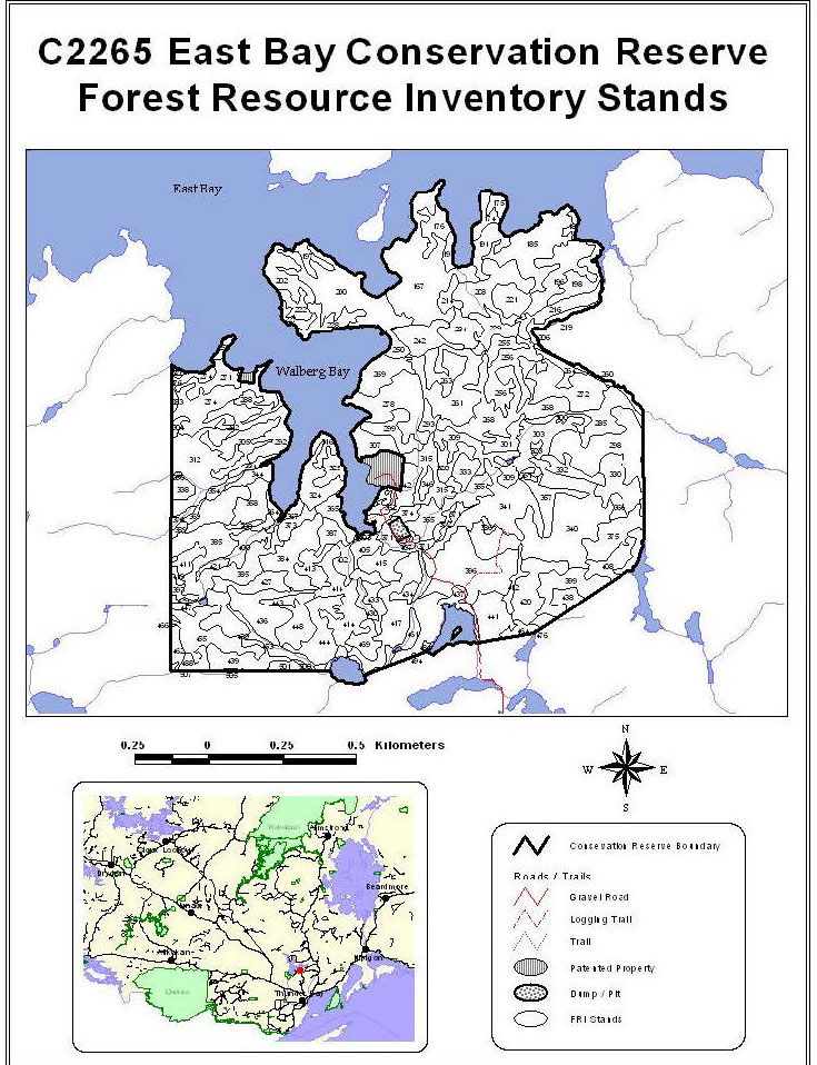
| Stand # | Working Group | Height | Stocking | Species |
|---|---|---|---|---|
| 167 | 7 | 20.0 | 0.8 | PJ 4PO 2BW 2SB 1B 1 |
| 174 | 11 | 18.0 | 0.8 | SB 5PO 3SW 1B 1 |
| 175 | 13 | 18.0 | 0.7 | B 4BW 3PO 2SB 1 |
| 176 | 13 | 18.0 | 0.5 | B 6PO 2SB 1BW 1 |
| 185 | 7 | 18.0 | 0.8 | PJ 4SB 2BW 2PO 1B 1 |
| 187 | 33 | 15.0 | 0.5 | PO 4SB 3BW 2B 1 |
| 191 | 11 | 20.0 | 0.6 | SB 4PO 3B 2PJ 1 |
| 193 | 36 | 16.0 | 0.6 | BW 4B 3PJ 2PO 1 |
| 196 | 33 | 22.0 | 0.9 | PO 7PJ 1BW 1B 1 |
| 197 | 11 | 14.0 | 0.8 | SB 5BW 3PO 1B 1 |
| 198 | 33 | 21.0 | 0.8 | PO 5PJ 3SB 1B 1 |
| 200 | 36 | 13.0 | 0.9 | BW 6SB 1PO 1PJ 1B 1 202 11 |
| 202 | 11 | 14.0 | 0.8 | SB 5BW 3PO 1B 1 |
| 206 | 33 | 22.0 | 0.7 | PO 5PJ 2SB 1BW 1B 1 |
| 208 | 7 | 17.0 | 0.8 | PJ 5SB 2PO 2B 1 |
| 214 | 11 | 19.0 | 0.6 | SB 8B 2 |
| 216 | 33 | 21.0 | 0.8 | PO 4B 3BW 2PJ 1 |
| 219 | 0 | 0.0 | 0.0 | |
| 221 | 33 | 20.0 | 0.9 | PO 4PJ 2B 2SB 1BW 1 |
| 222 | 33 | 20.0 | 0.8 | PO 4BW 3PJ 2SW 1 |
| 227 | 7 | 18.0 | 0.7 | PJ 4PO 2BW 2B 2 |
| 228 | 36 | 17.0 | 0.5 | BW 5SW 2SB 1PO 1B 1 |
| 229 | 0 | 0.0 | 0.0 | |
| 233 | 36 | 18.0 | 0.8 | BW 5PO 3SW 1B 1 |
| 234 | 7 | 17.0 | 0.9 | PJ 5SB 2PO 2B 1 |
| 242 | 11 | 14.0 | 0.8 | SB 5CE 3B 2 |
| 250 | 0 | 0.0 | 0.0 | |
| 255 | 11 | 18.0 | 0.7 | SB 5PJ 3SW 1B 1 |
| 256 | 36 | 15.0 | 0.9 | BW 6B 2PO 1PJ 1 |
| 258 | 33 | 24.0 | 0.7 | PO 4SB 3B 2PJ 1 |
| 260 | 0 | 0.0 | 0.0 | |
| 261 | 7 | 19.0 | 0.8 | PJ 7SB 2PO 1 |
| 263 | 11 | 19.0 | 0.7 | SB 4PJ 2BW 2B 2 |
| 264 | 11 | 17.0 | 0.8 | SB 5PO 2PJ 2B 1 |
| 268 | 36 | 16.0 | 0.7 | BW 4PO 2PJ 2B 2 |
| 269 | 36 | 14.0 | 0.8 | BW 5SB 2B 2SW 1 |
| 270 | 0 | 0.0 | 0.0 | |
| 271 | 7 | 18.0 | 0.7 | PJ 4BW 3SB 1PO 1B 1 |
| 272 | 7 | 19.0 | 0.8 | PJ 5PO 3BW 1B 1 |
| 274 | 36 | 14.0 | 0.9 | BW 5PO 2SW 1PJ 1B 1 |
| 278 | 7 | 19.0 | 0.7 | PJ 4SB 2PO 2B 2 |
| 283 | 7 | 17.0 | 0.9 | PJ 4BW 3B 2SB 1 |
| 285 | 11 | 15.0 | 0.7 | SB 5PJ 3PO 1B 1 |
| 288 | 36 | 14.0 | 0.5 | BW 4PO 2PJ 2B 2 |
| 292 | 36 | 14.0 | 0.7 | BW 4PO 3PJ 2B 1 |
| 293 | 11 | 18.0 | 0.6 | SB 9B 1 |
| 298 | 33 | 20.0 | 0.8 | PO 4BW 3SB 1PJ 1B 1 |
| 299 | 11 | 19.0 | 0.8 | SB 5PJ 3PO 1B 1 |
| 300 | 0 | 0.0 | 0.0 | |
| 301 | 36 | 15.0 | 0.5 | BW 4B 3PJ 2PO 1 |
| 303 | 33 | 17.0 | 0.6 | PO 3PJ 2BW 2B 2SB 1 |
| 304 | 36 | 14.0 | 0.6 | BW 7SW 2PJ 1 |
| 305 | 36 | 14.0 | 0.5 | BW 4PO 2PJ 2B 2 |
| 307 | 11 | 16.0 | 0.7 | SB 5B 3PJ 1BW 1 |
| 309 | 7 | 16.0 | 0.8 | PJ 4PO 3B 2BW 1 |
| 312 | 36 | 15.0 | 0.8 | BW 4PO 3B 2PJ 1 |
| 315 | 33 | 0.0 | 0.0 | PO 0 |
| 316 | 13 | 17.0 | 0.6 | B 5BW 3SB 1PJ 1 |
| 320 | 13 | 17.0 | 0.7 | B 5PO 2BW 2PJ 1 |
| 323 | 0 | 0.0 | 0.0 | |
| 324 | 36 | 18.0 | 0.7 | BW 4PJ 3B 2PO 1 |
| 329 | 7 | 18.0 | 0.7 | PJ 5SB 2PO 2BW 1 |
| 330 | 33 | 22.0 | 0.7 | PO 5BW 2B 2SB 1 |
| 332 | 11 | 14.0 | 0.9 | SB 4PJ 3PO 2B 1 |
| 333 | 7 | 18.0 | 0.5 | PJ 4B 3BW 2PO 1 |
| 334 | 13 | 18.0 | 0.5 | B 4BW 3SB 2PJ 1 |
| 340 | 11 | 15.0 | 0.9 | SB 4PO 3BW 2B 1 |
| 341 | 33 | 20.0 | 0.8 | PO 4B 3BW 2PJ 1 |
| 342 | 33 | 21.0 | 0.7 | PO 7BW 2B 1 |
| 344 | 13 | 21.0 | 0.8 | B 4SW 2PO 2BW 2 |
| 346 | 33 | 21.0 | 0.7 | PO 7BW 2B |
| 347 | 00 | 0.0 | 0.0 | |
| 351 | 0 | 0.0 | 0.0 | B 4SW 2BW 2SB 1PO 1 |
| 354 | 13 | 18.0 | 0.6 | PJ 5PO 3BW 1B 1 |
| 355 | 7 | 18.0 | 0.9 | |
| 356 | 0 | 0.0 | 0.0 | |
| 357 | 36 | 16.0 | 0.7 | BW 4PO 3SB 1PJ 1B 1 |
| 358 | 33 | 23.0 | 0.7 | PO 4BW 3B 2PJ 1 |
| 362 | 0 | 0.0 | 0.0 | |
| 364 | 0 | 0.0 | 0.0 | |
| 365 | 0 | 0.0 | 0.0 | |
| 366 | 11 | 14.0 | 0.7 | SB 9PJ 1 |
| 367 | 0 | 0.0 | 0.0 | |
| 368 | 11 | 15.0 | 0.5 | SB 8B 2 |
| 369 | 0 | 0.0 | 0.0 | |
| 371 | 0 | 0.0 | 0.0 | |
| 372 | 11 | 15.0 | 0.8 | SB 6PO 2SW 1B 1 |
| 373 | 11 | 9.0 | 0.7 | SB 7PJ 2B 1 |
| 374 | 11 | 12.0 | 1.0 | SB 9B 1 |
| 375 | 36 | 15.0 | 0.7 | BW 4SB 2PO 2B 2 |
| 376 | 36 | 14.0 | 0.9 | BW 7SB 1PO 1B 1 |
| 384 | 33 | 21.0 | 0.8 | PO 4BW 3B 2SB 1 |
| 385 | 36 | 17.0 | 0.7 | BW 4SB 2PJ 2PO 1B 1 |
| 386 | 0 | 0.0 | 0.0 | |
| 387 | 11 | 12.0 | 0.7 | SB 6PJ 3B 1 |
| 388 | 0 | 0.0 | 0.0 | |
| 389 | 0 | 0.0 | 0.0 | |
| 396 | 36 | 18.0 | 0.8 | BW 5PO 3PJ 1B 1 |
| 397 | 0 | 0.0 | 0.0 | |
| 399 | 11 | 15.0 | 0.7 | SB 5PJ 2BW 2B 1 |
| 400 | 11 | 11.0 | 0.4 | SB 8L 2 |
| 402 | 11 | 14.0 | 0.5 | SB 9L 1 |
| 403 | 0 | 0.0 | 0.0 | |
| 405 | 7 | 23.0 | 0.9 | PJ 6PO 3B 1 |
| 407 | 7 | 23.0 | 0.9 | PJ 6PO 3B 1 |
| 408 | 33 | 22.0 | 0.8 | PO 5BW 2B 2SB 1 |
| 411 | 11 | 15.0 | 0.6 | SB 8CE 1B 1 |
| 412 | 11 | 8.0 | 0.4 | SB 8L 2 |
| 413 | 36 | 16.0 | 0.7 | BW 5B 3SB 1PO 1 |
| 414 | 7 | 20.0 | 0.9 | PJ 6PO 2SB 1BW 1 |
| 415 | 33 | 23.0 | 0.8 | PO 4PJ 3SW 1BW 1B 1 |
| 417 | 7 | 23.0 | 0.9 | PJ 7PO 2B 1 |
| 419 | 11 | 10.0 | 0.4 | SB 6L 1CE 1BW 1B 1 |
| 420 | 33 | 18.0 | 1.0 | PO 4BW 3PJ 2B 1 |
| 421 | 0 | 0.0 | 0.0 | |
| 427 | 36 | 15.0 | 0.9 | BW 7B 2PO 1 |
| 429 | 36 | 15.0 | 0.6 | BW 5PO 2B 2SB 1 |
| 430 | 11 | 16.0 | 0.5 | SB 7B 2CE 1 |
| 433 | 33 | 23.0 | 0.8 | PO 4PJ 3SW 1BW 1B 1 |
| 434 | 33 | 23.0 | 0.8 | PO 4PJ 3SW 1BW 1B 1 |
| 436 | 7 | 19.0 | 0.8 | PJ 4SB 2BW 2SW 1B 1 |
| 437 | 11 | 16.0 | 0.6 | SB 8PO 1B 1 |
| 438 | 36 | 15.0 | 0.8 | BW 4PO 3SB 2PJ 1 |
| 439 | 36 | 16.0 | 0.7 | BW 4SW 2PO 2SB 1B 1 |
| 441 | 33 | 24.0 | 0.7 | PO 4SB 2BW 2PJ 1B 1 |
| 443 | 11 | 15.0 | 0.6 | SB 6BW 2B 2 |
| 444 | 36 | 16.0 | 0.7 | BW 4SB 2PO 2B 2 |
| 447 | 0 | 0.0 | 0.0 | |
| 448 | 36 | 16.0 | 0.9 | BW 6PO 2B 2 |
| 453 | 0 | 0.0 | 0.0 | |
| 455 | 36 | 14.0 | 0.9 | BW 8PO 1B 1 |
| 461 | 0 | 0.0 | 0.0 | |
| 466 | 36 | 15.0 | 0.6 | BW 4SB 3PO 2PJ 1 |
| 469 | 11 | 17.0 | 0.7 | SB 0 |
| 476 | 0 | 0.0 | 0.0 | |
| 484 | 7 | 22.0 | 0.9 | PJ 4PO 3BW 2B 1 |
| 488 | 36 | 12.0 | 0.4 | BW 4PO 3B 2SW 1 |
| 494 | 11 | 15.0 | 0.7 | SB 7L 2PO 1 |
| 500 | 11 | 15.0 | 0.6 | SB 0 |
| 505 | 11 | 16.0 | 0.6 | SB 7B 2BW 1 |
| 276 | 36 | 17.0 | 0.7 | BW 4SW 2SB 1PO 1PJ 1B 1 |
| 338 | 36 | 14.0 | 1.0 | BW 6SW 1SB 1PO 1B 1 |
| 393 | 36 | 15.0 | 1.0 | BW 8PO 1B 1 |
| 462 | 36 | 14.0 | 0.8 | BW 5SB 2PO 2PJ 1 |
| 464 | 7 | 19.0 | 0.9 | PJ 4PO 3SB 2BW 1 |
| 501 | 36 | 16.0 | 0.9 | BW 7PO 2B 1 |
| 507 | 36 | 15.0 | 0.9 | BW 8PO 1B 1 |