East Larder River Bedrock Conifer Conservation Reserve Management Statement
This document provides policy direction for the protection, development and management of the East Larder River Bedrock Conifer Conservation Reserve and its resources.
Kirkland Lake District
Ministry of Natural Resources
Approval Statement
I am pleased to approve this Statement of Conservation Interest (SCI) for the East Larder River Bedrock Conifer Conservation Reserve.
Direction for establishing, planning and managing conservation reserves is defined under the Public Lands Act and current policy. "Ontario’s network of natural heritage areas has been established to protect and conserve areas representative of the diversity of the natural regions of the province, including species, habitats, features, and ecological systems which comprise that natural diversity." (Policy 3.03.05, MNR 1997).
This SCI will provide guidance for the management of the East Larder River Bedrock Conifer Conservation Reserve and the basis for the ongoing monitoring of activities. More detailed direction at this time is not anticipated. Should significant facility development be considered or complex issues arise requiring additional studies, more defined management direction, or special protection measures, a more detailed Conservation Reserve Management Plan will be prepared with full public consultation.
The public was consulted on this site prior to its regulation during the planning for Ontario’s Living Legacy (MNR, 1999). Furthermore, the public was notified during a 30 day period in September, 2002 concerning a draft of this SCI. Comments from the notification period have been considered in the development of this document.
The East Larder River Bedrock Conifer Conservation Reserve will be managed under the jurisdiction of the Kirkland Lake/Claybelt Area Supervisor of the Ministry of Natural Resources, Kirkland Lake District.
Plan Author:
William Foy
Ontario’s Living Legacy Resource Manager
Kirkland Lake District
Approved by:
Craig Greenwood
District Manager:
Approved by:
Rob Galloway
Regional Director:
1.0 Introduction
Ontario’s network of natural heritage areas has been established to protect and conserve areas representative of the diversity of the natural regions of the province, including species, habitats, features and ecological systems which comprise that natural diversity. Protected natural heritage areas are a key component in sustainable management of natural resources. They ensure that representative sites within the larger sustainably managed landscape are permanently retained in their natural state.
Natural Heritage areas are considered to be sensitive, requiring protection from incompatible activities if their values are to endure over time. The Ministry of Natural Resources has established conservation reserves as a new tool to offer protection for these areas on public lands, while permitting many traditional public uses to continue. Such uses include the traditional activities of Aboriginal Peoples.
Ontario’s Living Legacy Land Use Strategy (OLL LUS) MNR, 1999) sets the direction for the administration and management of parks and protected areas on Crown lands within three planning regions including; the Boreal West, Boreal East and Great Lakes – St. Lawrence areas. This strategy’s natural heritage objectives include protection of natural and cultural heritage values and the provision of opportunities for outdoor recreation, heritage appreciation and tourism.
Protected areas designated within the OLL LUS have been selected based on their representation of the spectrum of the province’s ecosystems and natural features including both biological and geological features, while minimizing impacts on other land uses. Representation was described using landform and vegetation combinations based on Hill’s (1959) site district concept.
The East Larder River Bedrock Conifer Conservation Reserve is a 7,003 ha parcel of Crown land that is situated about 27.5 km northeast of the town of Englehart. It is located in the townships of McFadden, Rattray, Bayly and Mulligan and in the Township of Skead in the municipal township of Larder Lake. These townships are located in the Kirkland Lake District within the MNR’s Northeast Region. The East Larder River Bedrock Conifer Conservation Reserve will be managed under a Statement of Conservation Interest (SCI).
SCI documents are the minimum level of management direction established for any conservation reserve and generally are brief management plans. This SCI will govern the lands and waters within the regulated boundary of the East Larder River Bedrock Conifer Conservation Reserve. However, to ensure MNR protection objectives are being fully met within this conservation reserve, management of the surrounding landscape and related activities should consider the site’s objectives and heritage values. In addition, it is the intent of the SCI to create public awareness that will promote responsible stewardship of protected areas and surrounding lands. With management partners such as Ontario Parks, industry, and local governments. MNR District staff will be able to pursue and advance sound environmental, economic and social strategies and policies related to the protection of conservation reserves and provincial parks.
The purpose of this SCI is to identify and describe the values of the East Larder River Bedrock Conifer Conservation Reserve and outline the Ministry’s management intent for the conservation reserve. The management direction will protect the site’s natural heritage values and demonstrate its compatibility within the larger sustainable landscape. This direction will comply with land use intent as stated by the OLL Land Use Strategy (MNR, 1999).
2.0 Goals and Objectives
2.1 Goals of Statement of Conservation Interest
The goal of this SCI is to describe and protect natural heritage values on public lands while permitting compatible land use strategies.
2.2 Objectives of SCI
2.2.1 Short Term Objectives
The short-term objectives are to identify the State of Resource with respect to natural heritage values and current land use activities for the East Larder River Bedrock Conifer Conservation Reserve. A priority will be placed on the protection of the site’s natural values via specific guidelines, strategies and prescriptions detailed in this plan. Finally, legislated planning requirements will be met (e.g. SCI development within three years of regulation).
2.2.2 Long Term Objectives
The long-term objectives are to establish representative targets (e.g. future forest conditions) and validate the site as a potential scientific benchmark. To ensure protection of natural and cultural heritage features and values, this SCI will establish an evaluation process to address future new uses and commercial activities associated with them (e.g. Test of Compatibility Procedural Guideline B in Conservation Reserve Policy PL 3.03.05). Finally, this SCI will identify research/client services and marketing strategies.
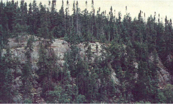
Figure 1. North Facing plateau cliffs located within the conservation reserve.
3.0 Management Planning
3.1 Planning Area
The planning area for this site will consist of the area within the regulated boundary for the East Larder River Bedrock Conifer Conservation Reserve (Locator Map, Appendix #7). The SCI will recognize the protection of values within the planning area; however, to fully protect values within the conservation reserve, the lands beyond the regulated boundary may require additional consideration within larger land use or resource management plans. Nevertheless, any strategies noted within this SCI related to the site’s boundary or beyond will need to be presented for consideration within a larger planning context.
3.2 Management Planning Context
The East Larder River Bedrock Conifer Conservation Reserve was first designated as a candidate conservation reserve by MNR in the OLL Proposed Land Use Strategy (MNR, March, 1999) and ultimately as a conservation reserve in the final OLL Land Use Strategy (MNR, 1999). The site was regulated with the filing of Ontario Regulation 148/02 made under the Public Lands Act on May 8, 2002. Management and planning direction for this site will follow the OLL LUS (MNR, 1999) and this management statement. The area encompassed by this site has also been removed from the Timiskaming Forest Alliance Inc. Sustainable Forest License (SFL) landbase.
By regulation, this conservation reserve cannot be used for commercial forest harvest, mining or hydroelectric power development. Existing permitted uses within this reserve may continue such as fishing, hunting and trapping. This SCI document and future management of the site will continue to try to resolve conflicts regarding incompatibility between uses and to ensure that identified values are adequately protected.
This SCI will only address known issues or current proposals with respect to permitted uses or potential economic opportunities brought forward to the District Manager during this planning stage. However, in terms of approving future permitted uses and/or development(s), there are established mechanisms in place to address such proposals. Any future proposals will be reviewed using the Procedural Guideline B - Land Uses – Test of Compatibility Public Lands Act Policy PL 3.03.05 (MNR, 1997) or other standard MNR environmental screening processes.
Consideration of proposals pertaining to cultural resources may be screened through Conserving a Future for our Past: Archaeology, Land Use Planning & Development in Ontario, Section 3 (MCzCR, 1997), or in processes such as that used by MNR to establishing Area of Concern (AOC) descriptions and prescriptions for cultural heritage resources within forest management plans (FMPs).
These planning tools will help refine the review process once the proposal satisfies the direction and intent of the Public Lands Act, associated policies and this planning document.
3.3 Planning Process
Once a conservation reserve is passed into regulation, it must be determined what level of management planning is required to fulfill the protection targets. There are two possible planning documents. A Statement of Conservation Interest (SCI) is the minimal requirement for providing planning direction. A Resource Management Plan (RMP) deals with more complex issues where several conflicting demands are placed on the resources. The guidelines for the preparation of these documents are outlined in Procedural Guideline A – Resource Management Planning (Conservation Reserves Procedure PL3.03.05 Public Lands Act). The appropriate plan must be completed within three years of the regulation date.
For current planning purposes, the East Larder River Bedrock Conifer Conservation Reserve will be managed under the auspices of a Statement of Conservation Interest. Interested parties from both the private and public sector were consulted during the OLL planning process from candidate conservation reserve to regulation. A 30-day public review of a draft of this SCI document occurred during late November and December 2002. The intent of this SCI is to fulfill the commitments made within the OLL LUS (MNR, 1999).
The revised SCI was reviewed by the Kirkland Lake District Manager (DM). Upon approval by the DM the SCI will be presented to the Regional Director (RD) for final approval.
Following RD approval, interested public, user groups and industry will be notified that the Statement of Conservation Interest for the East Larder River Bedrock Conifer Conservation Reserve was approved.
Public consultation will be solicited as part of any future reviews of land use proposals that would require new decisions to be made. In addition, any future proposal and/or any new, significant management direction considered will be published on the Environmental Bill of Rights Registry (EBR).
The SCI is a planning document that will provide background information, identify values to be protected and establish management guidelines for use in the administration of the reserve.
The implementation of the SCI will be the mandate of the MNR at the District level; however, associations with various partners may be sought to assist in the delivery. This SCI is a working document, and as a result, it may be necessary to make revisions to it from time to time.
Background Information
4.1 Location and Site Description
4.1.1 Location
The following table describes the location and provides administrative details of the site:
Table 1: Location Data
| Name | East Larder River Bedrock Conifer Conservation Reserve |
|---|---|
| Site Region – Site District (Hills) | 4E/5 |
| MNR Administrative Region/District Area | Northeast Region/Kirkland Lake District in the Kirkland Lake/Claybelt Area |
| Total Area | 7,003 ha |
| UTM co-ordinates | 066131 |
| Nearest Town/Municipality | Located within the municipal township of Larder Lake |
| Township(s) | McFadden, Skead, Rattray, Bayly, Mulligan |
| OBM Numbers | 5900 53000 / 5900 53100 / 6000 52900 6000 53000 / 6000 53100 / 6000 53200 |
| Topographical Map Name/Number | 31 M/13 and 32 D/4 |
| Wildlife Management Unit | 28 |
| Forest Management Unit | Timiskaming Forest |
4.1.2 Site Description
4.1.2.1. Physical Description
The East Larder River Bedrock Conifer Conservation Reserve is located about 27.5 km northeast of the town of Englehart. The conservation reserve is a 7,003 ha parcel of land located in McFadden, Skead, Bayly, Rattray and Mulligan townships. Bedrock in the conservation reserve is of the early and middle Precambrian Age and includes Archean metavolcanics, metasediments and plutonic rocks and Huronian sedimentary rocks (McKenzie and Lall, 1984). During the last ice age, material such as glacial till, glaciolacustrine clay and silt, glaciofluvial sand and gravel and ice-contact deposits such as eskers were deposited (McKenzie and Lall, 1984). The elevations in the conservation reserve range from 261 to 430 meters above sea level with the maximum height located near Icefish Lake in Rattray Township. The topography of the site is characterized by steep escarpment faces, talus slopes and high hills (Brownell, 1992).
4.2 Administrative Description
The legal boundaries of the East Larder River Bedrock Conifer Conservation Reserve were filed on December 18, 2001 with the Office of the Surveyor General, Ministry of Natural Resources in Peterborough, Ontario. This site was passed into regulation on May 8, 2002 (O.Reg. 148/02).
4.3 History of Site
The conservation reserve does not have any documented historical uses. Fishing, hunting and trapping have most likely occurred within the site. The site contains three Bear Management Areas, five baitfish areas, and three traplines.
4.4 Inventories
The following table indicates the current status of natural heritage inventory that has occurred or is required in the near future.
Table 2. Inventory Data
| Survey Level | Earth Science | Life Science | Cultural | Recreational | Other |
|---|---|---|---|---|---|
| Reconnaissance | Sept. 2000 | Sept. 2000 | Not required at this time | September2000 November 2002 |
|
| Detailed | |||||
| Requirement |
5.0 State of the Resource
Representation:
The majority of the East Larder River Bedrock Conifer Conservation Reserve consists of moderately broken bedrock with a large area of weakly broken bedrock in the eastern section of the site. The landform types include bedrock plateau, glaciolacustrine plain, glaciofluvial sediments, bedrock knob and outwash plain (Thompson, 2001).
Mixed spruce stands with significant past harvest disturbance dominate the eastern portions of the conservation reserve. Jack pine and associated mixed stands can be found south of Adamson Lake and on the bedrock plateaus northeast and south of Big Moose Lake. An area of old burn contains mixed stands of spruce, jack pine, white birch and poplar. Mixed stands of spruce, poplar and white birch cover the area east of Ward Lake south to Big Moose Lake. The glaciolacustrine plain southeast of Ginn Lake has been significantly altered and now contains some old white birch with white spruce and shrubs.
Wetlands are limited within the East Larder River Bedrock Conifer Conservation Reserve. The wetlands that are present range from low shrub shore fen to wet meadows with isolated open spruce bogs. There are a number of rivers, creeks and lakes found within or bordering the site. Included in these are Big Moose lake, Ginn Lake, Adamson Lake, Larder River, Raven Lake and Wendigo Lake.
Quality of Representation:
The quality of the representation or the current characteristics of the natural features found within the conservation reserve are as important as the overall representative features that are being protected. A number of factors are considered in evaluating a site and they include the following criteria: diversity, condition, ecological factors, special features and current land use activities.
a) Diversity:
Diversity is a measure of the site’s life and earth science heterogeneity. The evaluation is based on the number and range (variety) of the natural landscape features and landforms for earth science values and the relative richness and evenness of the site’s life science components. Natural landscapes and known generalized vegetation communities will be the scale used for this Statement of Conservation Interest.
Life science diversity for this site is rated as low based on the relatively few forest communities represented compared to the size of the site. The high disturbance level as a result of forest harvesting and the lack of extensive wetland and aquatic communities also contributes to a low diversity level. Future aerial or ground reconnaissance surveys will enhance the MNR’s knowledge of these features and possibly allow verification at a lower scale (e.g. species assemblages).
b) Condition:
Condition is the degree of past human and natural disturbances observed or recorded for the site.
Disturbance within the East Larder River Bedrock Conifer Conservation Reserve is considered high. Extensive harvesting has taken place in and around the site in the past fifteen years with the most recent activity in the eastern and southeastern parts of the conservation reserve. The regeneration of these areas has been poor or nonexistent. As a result of logging in this site logging roads are found running through many sections of the conservation reserve. In addition, the site contains cottages on Ginn Lake, a trappers cabin and three Land Use Permits (LUP) on Big Moose Lake.
c) Ecological Factors:
Ecological factors refer to the current design of the conservation reserve as noted by its size, shape, and buffering capacity to adjacent land use activities.
The East Larder River Bedrock Conifer Conservation Reserve is bounded by the Larder River Provincial Park to the southwest, west and northwest and by creeks in the southwest and south central parts of the site. Overall the boundaries of the site are a combination of biological and vectored. Vectored boundaries are formed by a series of points and line segments. The vectored boundaries and past disturbance in the conservation reserve limit the potential number of core values within the site.
d) Special Features:
The major features that are present within this conservation reserve include:
- Ginn Lake Plateau and Slope Complex
- Icefish Lake Area Plateau and Slope Complex
- Ward Lake Mixed Forest and Wetland Complex
- Middle Plateau and Slope Complex
- Big Moose Lake Wetland Complex
e) Current Land Use Activities
Activities include hunting, trapping, ATV use, snowmobiling, and hiking.
Summary:
East Larder River Bedrock Conifer Conservation Reserve is listed in the OLL LUS (MNR, 1999) as protecting a landform type represented by moderately broken bedrock with dense coniferous forests, mixed coniferous forests, mixed deciduous forests, and sparse forests. The diversity of species and condition of the conservation reserve have been affected by past forest harvesting practices in the area. The number of roads and trails leading into the conservation reserve increases the potential for further disturbance to the site. Future planning should consider present values and existing uses within the conservation reserve.
Forest Resource Inventory (FRI) Data
- Dominant species, wetlands, and depleted areas
- See Tree Species Composition Map, Appendix #8
5.1 Social/Economic Interest in Area
a) Linkage to Local Communities:
The East Larder River Bedrock Conifer Conservation Reserve is located about 27.5 km northeast of the town of Englehart. The conservation reserve is a 7,003 ha parcel of land located in McFadden, Skead, Bayly, Rattray and Mulligan townships.
Current uses are related to consumption of wildlife resources, such as hunting and trapping. Ridges, cliff faces and current access routes would favour potential recreational activities such as rock climbing, landscape viewing and hiking.
b) Heritage Estate Contributions
The East Larder River Bedrock Conifer Conservation Reserve contributes to the province’s parks and protected areas system through its regulation, representation and the long-term management of its natural heritage values. By allocating these lands to the parks and protected areas system, the province has ensured a certain level of permanence by distinguishing the site and its values from the broader general use and more extensively managed landscape. In addition, its natural features are, and will be available for present and future generations to enjoy and explore.
c) Aboriginal Groups
The site is located within the Beaverhouse Aboriginal Community’s area of interest.
d) Mining Interests:
There are no known current mining interests within the conservation reserve. Mining and surface rights have been withdrawn from staking within the conservation reserve’s boundaries under the Mining Act (RSO 1990 Chapter M.14).
e) Forest and Fire Management History:
Extensive clear cutting occurred in Bayly township during the 1950’s. There have been recent forest management practices within the boundary of the conservation reserve. The site also has no recent burned areas within its boundary. Fire disturbances occurred during the 1920’s in the northwest portion of the conservation reserve.
5.2 Natural Heritage Stewardship
5.3 Fish and Wildlife
Only one large moose aquatic feeding area is found within the conservation reserve and is assessed as a class 4 (very high potential). Moose Aerial Inventory Surveys done by the Ministry of Natural Resources indicate a sustainable moose population with heavy summer use within the conservation reserve. In 1989 and 1990, white-tailed deer were sighted during winter flights by the Ministry of Natural Resources.
A survey of Big Moose Lake indicates the presence of pike, white sucker and yellow perch. The lake has a maximum depth of 12 m and is 76 ha in size. A survey of Ginn Lake indicated that no fish were present. The lake has a maximum depth of 17 m and is 19.5 ha in size. A survey of Adamson Lake indicates the presence of yellow perch. The lake was stocked with brook trout in 1954; however, no brook trout were caught during assessments conducted in 1987. The lake has a maximum depth of 8.5 m and is 34.8 ha in size.
5.4 Cultural Heritage Stewardship
To date, a detailed assessment of cultural resources has not been carried out.
5.5 Land Use/Existing Development
The conservation reserve is situated entirely on Crown Land and is unencumbered by any leases or mining claims. Three land use permits are located on the west shore of Big Moose Lake. Mining and surface rights have been withdrawn from the reserve (MNDM G-Plan M-0282 December 12, 2001).
5.6 Commercial Land Use
Present commercial use activities include two bear management areas (KL-28-027, KL-28-007), four traplines (KL-73, KL-74, KL-75, KL-80), and five baitfish operations. (Values Map, Appendix #8).
5.7 Tourism/Recreation Use/Opportunities
Some of the features of the site and surrounding area, associated with possible recreation use, include large and small mammals, mixed forests, ridges and cliff faces. Existing recreational uses in this site and the area immediately surrounding the site include trapping, large game hunting, small game hunting, ATV use, snowmobiling, and fishing. There is also potential for activities such as rock climbing, bird watching, canoeing and nature study.
For a more detailed report and summary of the recreational use and potential, refer to the Recreational Inventory Checksheet (Appendix 3).
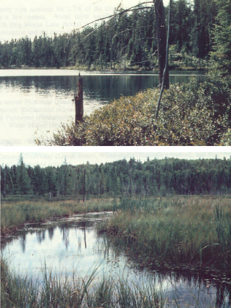
Figure 2. North side of Ginn Lake (top) and bog community on west shoreline of Big Moose Lake (bottom).
5.8 Client Services
Currently, visitor services are limited to responding to inquiries about access, natural heritage features and boundaries. No formal information or interpretive facilities currently exist within the conservation reserve. Other client services include providing clients with access to maps, fact sheets, and other information gathered on the area, such as the Earth/Life Sciences and recreational inventory work.
6.0 Management Guidelines
6.1 Management Planning Strategies
The land use intent outlined in the OLL LUS (MNR, 1999) provides context and direction to land use, resource management, and operational planning activities on Crown Land in the planning area and within OLL site boundaries. Commitments identified in the OLL LUS and current legislation (Policy 3.03.05 PLA) forms the basis for land use within the East Larder River Bedrock Conifer Conservation Reserve. Management strategies for these uses must consider the short and long-term objectives for the reserve. For up to date information on permitted uses refer to the Crown Land Use Atlas (MNR, 2002) (/page/crown-land-use-policy-atlas)
Proposed new uses and development will be reviewed on a case-by-case basis. A Test of Compatibility, (Procedural Guideline B – Land Uses (PL 3.30.05) must be passed before they are deemed acceptable. In all cases, ensuring that the natural values of the conservation reserve are not negatively affected by current and future activities will be a priority. Therefore any application for new specific uses will be carefully studied and reviewed.
6.2 "State of the Resource" Management Strategies
The development of this SCI and the long term management and protection of the East Larder River Bedrock Conifer Conservation Reserve will be under the direction of the MNR’s Kirkland Lake District, Kirkland Lake/Claybelt Area Supervisor. The following management strategies have been created to achieve the goal and objectives stated earlier in this management document.
Natural Heritage Stewardship
The management intent for the East Larder River Bedrock Conifer Conservation Reserve is to allow for natural ecosystems, processes and features to operate undisturbed with minimal human interference while providing educational, research and recreational activities.
Forest fire protection will be carried out as on surrounding public lands, under the direction of the provincial fire strategy. All wildfire occurrences will be considered a high priority and will actively be suppressed. Prescribed burning will be conducted only under the direction of the provincial fire strategy and authorized for the conservation reserve under a separate vegetation management plan. Prescribed burning may be utilized if deemed necessary to emulate natural disturbances and renew forest communities, prepare seed beds for research and/or education purposes or to meet additional objectives determined within a separate vegetation management plan.
Defining compatible uses, enforcing regulations and monitoring and mitigating issues will protect all earth and life science features. Industrial activities such as commercial timber harvest and new hydro generation will not be permitted within the conservation reserve. Permits for fuel-wood will not be issued. New energy transmission, communication and transportation corridors or construction of facilities are not permitted within the boundaries of the conservation reserve. Such structures negatively impact the quality of the representative features that require protection. Alternatives should be reviewed via larger landscape planning processes. New roads for resource extraction will not be permitted. Other activities that do not pass a Test of Compatibility will be prohibited (MNR Policy 3.03.05, 1997).
The introduction of exotic and/or invasive species will not be permitted. Programs may be developed to control forest insects and diseases where they threaten significant heritage, aesthetic, or economic values. Where control is desirable, it will be directed as narrowly as possible to the specific insect or disease. Biological or non-intrusive solutions should be applied whenever possible.
The collection/removal of vegetation and parts thereof will not be permitted; however, subject to a Test of Compatibility, the Area Supervisor may authorize such activities for purposes of rehabilitating degraded sites within the reserve, collecting seeds for maintaining genetic stock and/or for inventory or research purposes.
MNR will provide leadership and direction for maintaining the integrity of this site as a heritage estate. To ensure MNR protection objectives are fully met within the conservation reserve, activities on the surrounding landscape must consider the site’s objectives and heritage values. Research, education and interpretation will be encouraged to provide a better understanding of the management and protection of the natural heritage values and will be fostered through local and regional natural heritage programs, initiatives and partnerships.
The conservation reserve will be managed by allowing natural ecosystems, processes, and features to function normally, with minimal human interference.
Fish and Wildlife
Fish and wildlife resources will continue to be managed in accordance with specific policies and regulations defined by the Ontario Ministry of Natural Resources under the Fish and Wildlife Conservation Act and the Kirkland Lake District, Kirkland Lake/Claybelt Area Supervisor.
Fishing and hunting is expected to continue at a low level of intensity. A planned trail and viewing area development may enhance wildlife viewing activities. Any future trail development will require a test of compatibility.
Cultural Heritage
When possible, the Ministry of Natural Resources will continue to work with the Ontario Ministry of Culture, Tourism and Recreation in identifying archaeological sites to be protected. To more fully manage and protect sites, the development of field surveys would be required. However, at this time additional field surveys within this conservation reserve are not recommended.
Development, research and education proposals may be considered in accordance with the Test of Compatibility and Conserving a Future for our Past: Archaeology, Land Use Planning & Development in Ontario, Section 3 (MCzCR, 1997).
Land Use and Development
The sale of lands within the conservation reserve is not permitted as per the OLL LUS (MNR, 1999). Existing authorized trails can continue to be used and maintained, unless there are significant demonstrated conflicts. New trails will only be allowed if a Test of Compatibility is passed. The cutting of trees for non- commercial purposes (e.g. fuelwood) is not permitted except as required for approved development activity (e.g. trail, viewing site, etc.).
New roads for resource extraction will not be permitted. Abandoned forest extraction roads will not be actively maintained. There are no other forms of tenure in the conservation reserve other than legal agreements with registered trappers, bear management area operators and baitfish licensees. No new trap cabins will be permitted.
Traditional uses within the conservation reserve will continue to be permitted; however, the goal will be to resolve conflicts regarding incompatibility between uses and to ensure that identified values are adequately protected.
Commercial Use
All existing commercial bait fishing and commercial bear hunting (within BMAs) operations are permitted to continue. Commercial bear hunting operations is permitted and the transfer of existing licenses is allowed.
Existing commercial fur harvesting operations are permitted to continue. New operations may be considered subject to a Test of Compatibility.
Aboriginal Interests
The East Larder River Bedrock Conifer Conservation Reserve is within the Beaverhouse Aboriginal Community’s area of interest. Aboriginal and treaty rights will continue to be respected throughout the management of this conservation reserve. Any future proposal(s) and or decision(s) that have potential impact(s) on individual aboriginal values and or communities will involve additional consultation with the affected aboriginal groups.
Tourism/Recreation
The earth and life science features and their protection, shall be the overall theme for tourism. Small-scale infrastructures for enhancing tourism and recreation (i.e., warm-up shelter) may be considered, providing they pass a Test of Compatibility and other MNR requirements.
Most recreational activities that have traditionally been enjoyed in the area can continue provided they pose no threat to the natural ecosystems and features protected by the conservation reserve. These permitted activities include walking, hiking, wildlife viewing, fishing, hunting, snow shoeing, and cross-country skiing.
Snowmobiles and All Terrain Vehicles (ATVs) are permitted on existing trails and forest access roads within the Conservation Reserve. Under the OLL LUS (MNR, 1999), all mechanized travel is restricted to existing trails. Off trail vehicle use is permitted for the retrieval of game only. The use of existing trails, within the East Larder River Bedrock Conifer Conservation Reserve, does not degrade the values of this site.
Existing trails for hiking, snowmobiling, ATV use, cycling, horseback riding and cross-country skiing can continue. To ensure the quality of the representation is maintained, all trails and old forest access roads within the site should be identified via new technologies (i.e. GPS) to ensure a record of these features exist. New trails can be considered through a Test of Compatibility.
Finally, conflict resolution between recreational uses will be a priority. This will be achieved by adhering to the objectives of this SCI with input from relevant user groups. The level of safety and compatibility between activities will determine permitted uses (i.e.Test of Compatibility).
Client Services
Clients indicating their interest in the management, planning and future use of this conservation reserve will be put on a mailing list and notified of any future planning related to the site.
Present client services such as supplying maps, fact sheets and other information will also continue. Information may be delivered from different sources; however, MNR will be the lead agency for responding to inquiries regarding access, permitted and restricted activities, values and recreation opportunities. A management agreement may be pursued with an appropriate partner to share responsibilities for information services and the delivery of other aspects of this SCI in the future.
6.3 Specific Feature/Area/Zone Management Strategies
There are no specific management strategies for the maintenance/protection/enhancement of selected resources within the conservation reserve. Development of such strategies will require an amendment to the SCI.
6.4 Promote Inventory, Monitoring and Assessment Reporting (IMAR), and Research
Scientific research by qualified individuals, which contributes to the knowledge of natural and cultural history and to environmental and recreational management, will be encouraged.
Additional life science inventory or research is required at this time to refine values and features. Additional assessment and monitoring of the disturbed areas, including trail and old road locations, within the site should occur prior to any additional management direction being finalized in a vegetation management plan for the area.
Research related to the study of natural processes will be encouraged provided it does not harm the values of the reserve. The Kirkland Lake/Claybelt Area Supervisor or District Manager may approve the removal of any natural or cultural specimen by qualified researchers. All such materials removed remain the property of the Ministry of Natural Resources. All research programs will require the approval of the Ministry of Natural Resources and will be subject to Ministry policy and other legislation.
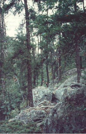
Figure 3. Open Jack Pine forest at the edge of a plateau
New research developments such as campsites, privies, trails or developed access points or activities will not be considered until a Test of Compatibility is conducted and the proposal is approved by the Kirkland Lake/Claybelt Area Supervisor or District Manager. The Test of Compatibility or environmental screening process could include a review of the demand for structures or activities and may require more detailed life or earth science or cultural information and possibly a more detailed resource management plan.
Approved research activities and facilities will be compatible with the site’s protection objective. Permanent plots or observation stations may be established to which researchers can return over time. Any site that is disturbed will be rehabilitated as closely as possible to its original state.
6.5 Implementation, and Plan Review Strategies
East Larder River Bedrock Conifer Conservation Reserve Statement of Conservation Interest will be reviewed on an ongoing basis and as required.
Implementation of the SCI and management of the reserve are the responsibility of the Kirkland Lake/Claybelt Area Supervisor. Partnerships may be pursued to address management needs.
If changes in management direction are needed at any time, the significance of the changes will be evaluated. Minor changes that do not alter the overall protection objectives may be considered and approved by the District Manager without further public consultation and the SCI will be amended accordingly. In assessing major changes, the need for a more detailed Resource Management Plan will first be considered. Where a management plan is not considered necessary or feasible, a major amendment to this SCI may be considered with public consultation. The Regional Director must approve major amendments.
6.6 Marketing Strategies
East Larder River Bedrock Conifer Conservation Reserve will be marketed as a representative natural area having earth and life science values, as well as certain recreational values. Marketing efforts to increase use are not a priority and will be kept to a minimum.
6.7 Boundary Identification
There is no stated policy to mark the boundaries of a conservation reserve.Local management discretion can be used to determine where boundary marking may be appropriate. In order for restrictions to be enforceable, signs must be placed in accordance with the Trespass to Property Act or subsection 28 (1) of the Public Lands Act to advise against any recreational activities.
7.0 References
1983. Ontario Ministry of Natural Resources. Kirkland Lake District Land Use Guidelines.
1990. Trespass to Property Act. Government of Ontario. Queen’s Printer. Toronto.
1992. Mining Act. Government of Ontario. Queen’s Printer. Toronto.
1993. Public Lands Act. Government of Ontario. Queen’s Printer. Toronto.
1997. Fish and Wildlife Conservation Act. Government of Ontario. Queen’s Printer. Toronto.
1997. Conservation Reserve Policy and Procedure PL 3.03.05. Ontario Ministry of Natural Resources. 30pp.
Ontario Ministry of Natural Resources, Ontario Living Legacy Land Use Strategy, July 1999.
Saturday, 21st April, 2001. The Ontario Gazette, Volume 134-16. Queen’s Printer. Toronto.
Bostock, H. S. Physiographic Subdivisions of Canada. Geology and Economic Minerals of Canada.
Harris, A. G., et. al. Field Guide to the Wetland Ecosystem Classification for Northwestern Ontario. Natural Resources Canada. May 1996.
Rowe, J. S. Forest Regions of Canada. Department of Fisheries and the Environment Canadian Forestry Service. 1972.
Brownell, V.R. A Biological Inventory and Evaluation of the Larder River Area of Natural and Scientific Interest. Ontario Ministry of Natural Resources. Kirkland Lake District. February 1992.