Echo River Hardwoods Conservation Reserve Management Statement
This document provides policy direction for the protection, development and management of the Echo River Hardwoods Conservation Reserve and its resources.
Statement of Conservation Interest (C246)
Ministry of Natural Resources
Sault Ste. Marie District
Algoma Area
February, 2004
Ce document est seulement disponsible en anglais.
Approval statement
I am pleased to approve this Statement of Conservation Interest (SCI) for Echo River Hardwoods Conservation Reserve (C246).
Echo River Hardwoods Conservation Reserve protects an area of spectacular rugged topography that is relatively inaccessible. The conservation reserve is considered to be a provincially significant site due to the presence of red oak mixed-wood communities near the northern limits of their range in Ontario, and due to a series of sugar maple dominated forests unique to Site District 4E-3. Regulated on April 6, 2001, this 10,244 hectare conservation reserve is situated approximately 35 kilometres east of the City of Sault Ste. Marie, in Chesley, Gillmor, Kane, Chesley Additional, McMahon, and Morin Townships.
Direction for establishing, planning and managing conservation reserves is defined under the Public Lands Act, the Ontario’s Living Legacy Land Use Strategy, and other applicable policies. The specific direction for managing this conservation reserve is in the form of a basic SCI, which defines the area to which the plan applies, provides the purpose for which the conservation reserve has been proposed, and outlines the Ministry of Natural Resources' management intent for the protected area. This SCI has been created with input from program specialists within Sault Ste. Marie District. It will provide both the foundation for the continued monitoring of activities and guidance for the management of the conservation reserve. More detailed direction at this time is not anticipated. However, should significant facility development be considered or complex issues arise requiring additional studies, more detailed management direction in the form of special protection measures, or a detailed Resource Management Plan, will be prepared with full public consultation.
Public and Aboriginal consultation occurred prior to the regulation of this conservation reserve. An additional 15-day consultation period took place in December 2003 that provided stakeholders with an opportunity to comment on the draft SCI. Comments from the review period have been considered in the development of this document.
The management guidelines outlined in this SCI will be implemented by the Algoma Area Supervisor, and will be reviewed every five years and amended as required by the District Planner, Sault Ste. Marie District, Ministry of Natural Resources.
Written by:
Gerry Morin,
OLL Tech. and Marjorie Hall,
OLL Planner
Date: February 2, 2004
Submitted by:
Erin Nixon,
District Planner
Date: February 5, 2005
Recommended for approval by:
Ron Reffle
Algoma Area Supervisor
Date: February 24, 2004
Recommended for approval by:
Serge Tenaglia R.P.F.
District Manager, Sault Ste., Marie District
Date: February 24, 2004
Approved by:
Rob Galloway
Regional Director, Northeast Region
Date: April 2, 2004
1.0 Introduction
The following document is a Statement of Conservation Interest (SCI) for Echo River Hardwoods Conservation Reserve (C246). The purpose of this SCI is to identify and describe the natural, recreational, and cultural values of Echo River Hardwoods Conservation Reserve and to outline the Ministry of Natural Resources' management intent for this area. The first three sections of this document highlight the provincial context in which it was produced, state its goal and objectives, and summarize the planning process for conservation reserves. Sections 4 through 7 are specific to Echo River Hardwoods Conservation Reserve and provide background information and management direction for the site. Section 8 outlines the requirements for continued implementation and review of this document.
Management direction specified in this SCI will serve to protect the conservation reserve for the benefit of all Ontario residents. This direction will comply with the land use intent stated in the Ontario’s Living Legacy Land Use Strategy (LUS) (OMNR 1999) and associated policy clarification statements. Additionally, this conservation reserve will be managed under the Public Lands Act (OMNR 1997a), and will comply with all legal requirements as specified under the Environmental Assessment Act (R.S.O. 1990, Chapter E.18).
1.1 Provincial context
Ontario’s network of natural heritage areas has been established to protect and conserve areas representative of the diversity of the natural regions of the province, including the species, habitats, features, and ecological systems which comprise that natural diversity. Protected natural heritage areas are a key component in the sustainable management of natural resources. They ensure that representative sites within the larger managed landscape are retained in as natural state as possible.
On July 16, 1999, the LUS (OMNR 1999) was released to guide the planning and management of much of Ontario’s Crown lands. Extensive consultation was conducted during the development of the LUS (OMNR 1999). The objectives of the LUS (OMNR 1999) are to complete Ontario’s system of parks and protected areas; recognize the land use needs of the resource-based tourism industry; provide forestry, mining and other resource industries with greater certainty around land and resource use; and, enhance hunting, angling and other Crown land recreational opportunities (OMNR 1999).
The LUS (OMNR 1999) contributes to completing Ontario’s system of protected natural heritage areas by designating 378 new areas to be protected. These areas are considered to be significant and require protection from incompatible activities in order for their values to endure over time. Echo River Hardwoods Conservation Reserve forms part of Ontario’s network of natural heritage areas. It protects a pattern of extensive uplands and deep valleys associated with the Upper Echo River and its tributaries. The site is considered to be provincially significant due to the presence of red oak (Quercus rubra L.) mixed-wood communities near their northern limits in Ontario and the best example of extensive sugar maple (Acer saccharum Marshall) dominated forests growing on steep hills with shallow sands and exposed bedrock in Site District 4E-3 and SE-1 (Noordhof and Thompson 2003).
The Ministry of Natural Resources has established conservation reserves as a tool to protect natural heritage areas on public lands, while permitting most traditional public land uses to continue. These uses include recreational activities, such as hunting and fishing, and the traditional activities of Aboriginal communities, as defined under applicable Aboriginal treaties. Lands designated as conservation reserves in the LUS (OMNR 1999) are removed from the Sustainable Forest License area, and mining and surface rights are withdrawn from staking under the Mining Act (RSO 1990 Chapter M.14).
The LUS (OMNR 1999) and subsequent policy clarification statements outline the general land use policy and management direction for new conservation reserves. Each new conservation reserve will have a planning document, either a SCI or, in more complex situations, a Resource Management Plan, that details site-specific management direction.
2.0 Goal and objectives of the SCI
2.1 Goal
The goal of this SCI is to provide the framework and the direction to guide management decisions affecting Echo River Hardwoods Conservation Reserve.
2.2 Objectives
The following objectives are identified as the means to achieve the above stated goal:
- To describe the site’s current state of the resource in terms of its values and existing uses and activities.
- To outline the Ministry of Natural Resources' management intent for the protected area.
- To determine the land use compatibility of current land uses, and to develop specific guidelines and prescriptions to manage these uses.
- To create public awareness of the values within this conservation reserve by providing information on the resources it contains and protects, and to support responsible stewardship through partnerships with local stakeholders.
- To identify research, client services, and/or marketing strategies that may contribute to sound long-term management of the conservation reserve.
- To identify the monitoring and/or research necessary to maintain the integrity of protected values.
- To provide direction for the evaluation of proposed new uses or economic ventures through the application of the Test of Compatibility (see Appendix C) and applicable Environmental Assessment Act legislation. This test will evaluate the impact of suggested use(s), either positive or negative, on the protected values of the conservation reserve.
3.0 Management planning
3.1 Planning for a conservation reserve
The planning process for a conservation reserve consists of regulating the site and preparing a site specific management plan. Consultation with the public, Aboriginal communities, and industry occur during site identification, boundary finalization, and management planning. Regulation of a conservation reserve involves preparing a legal description of site boundaries, removing the site from the Sustainable Forest Licence area, and withdrawing the site from staking under the Mining Act (RSO 1990 Chapter M.14). Once a conservation reserve is regulated, the level of management planning required to fulfill the protection targets is determined, and either a basic or enhanced SCI or a Resource Management Plan is prepared.
A basic SCI is prepared when there is no deviation from the land use direction provided in the LUS (OMNR 1999) and there are few to no issues that require resolution. Alternatively, a Resource Management Plan (RMP) is prepared in situations where one or more complex issues have to be addressed, or where there is widespread public interest in a site. An enhanced SCI is an intermediary document which is used when a site requires more detailed management direction than would be provided by a basic SCI, but does not have issues significant enough to warrant the preparation of a RMP. Whichever the determination, the plan must be completed within three years of the conservation reserve’s regulation date. The guidelines for the preparation of these documents are provided in Procedural Guidelines A - Resource Management Planning (Conservation Reserves Procedure PL3.03.05, Public Lands Act, OMNR 1997a) and the Northeastern Region Guidelines on the Planning Process for Conservation Reserves: Statement of Conservation Interest and Resource Management Plan (Thompson 2001).
A SCI is essentially a management plan, which receives its direction from the LUS (OMNR 1999). The purpose of a SCI is to identify the state of the resource in terms of the site’s values and its current land use activities, and to outline the Ministry of Natural Resources' management intent for the conservation reserve. Basic SCIs typically have a 15-day public consultation period, whereas enhanced SCIs and RMPs have a longer consultation period. Upon completion of this public review, the SCI, or RMP, is revised as necessary and approved by the appropriate Regional Director.
Existing permitted uses within conservation reserves may continue, unless they are shown to have a significant negative impact on the values protected by the site. A review/evaluation mechanism is in place to address proposed new permitted uses or land use proposals. The Test of Compatibility (see Appendix C) as outlined in the Public Lands Act Policy PL 3.03.05 (OMNR 1997a), and/or other standard Ministry of Natural Resources' environmental screening processes, are used to screen future proposals. Where cultural resources may be impacted, proposals may be screened through Conserving a Future for our Past: Archaeology, Land Use Planning & Development in Ontario, Section 3 (MC 1997).
Public comment may be solicited during a review of any future land use proposals that require new decisions to be made. Appropriate Environmental Assessment Act (R.S.O. 1990, Chapter E.18) requirements and amendment processes will apply to any future proposal and/or any significant change in management direction being considered for a site.
3.2 Planning process for Echo River Hardwoods Conservation Reserve
Echo River Hardwoods Conservation Reserve was proposed as a conservation reserve in the LUS (OMNR 1999). Consultation has occurred with the public, Aboriginal communities, and industry, and the boundary of the site has been regulated through an amendment to Ontario Regulation 805/94 of the Public Lands Act on April 6, 2001, by Ontario Regulation 86/01. A copy of public consultation documents can be found in Appendix E.
To date, no significant issues related to land use in this area have been identified. For this reason, it was determined that a basic SCI will adequately identify the site’s significant features and serve as the appropriate format for providing the management guidelines. It should be noted that this document addresses only those issues or land use proposals currently known to the District Manager. The direction provided by this SCI, and future management decisions, will work to resolve any potential land use conflicts and to ensure that identified values continue to be adequately protected.
3.2.1 Planning area
The planning area for this SCI consists solely of the regulated boundary for Echo River Hardwoods Conservation Reserve (see Appendix A, Map 1). However, to fully protect values within the conservation reserve, the area beyond the regulated boundary may require additional consideration when larger land use planning initiatives pose potential negative impacts on the conservation reserve. The forest management planning process is an example of how adjacent land management may consider sensitive features within the conservation reserve boundary.
4.0 Background information
4.1 Location and site description
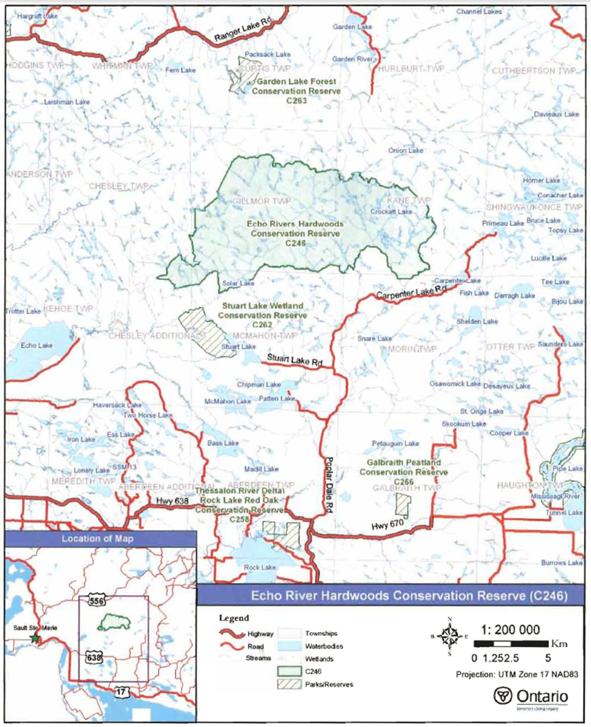
Echo River Hardwoods Conservation Reserve is located approximately 35km east of the City of Sault Ste. Marie and 20 km northeast of the Town of Echo Bay, in Chesley, Chesley Additional, Gillmor, Kane, McMahon and Morin Townships (see Figure 1). This site was regulated on April 6, 2001 and is 10,244 hectares in size. Table 1 summarizes the administrative details of the site.
Whenever possible, recognizable natural and cultural features, such as creeks, shorelines, or old roads have been used to delineate conservation reserve boundaries to facilitate on-the-ground identification (see Appendix A, Map 1). The southern boundary of Echo River Hardwoods Conservation Reserve follows the Echo River and one of its tributaries. The eastern boundary follows the Thessalon River and a series of unnamed creeks. A portion of the site’s northern boundary follows Mink Creek Road, also know as Onion Lake Road. The remainder of the northern boundary and a large portion of the western boundary are defined by a series of unnamed creeks. Vectored boundaries (straight lines connecting two points) generally play a small role in the overall configuration of the site; however, due to a lack of suitable natural or cultural features, vectors were used to delineate portions of the northwest boundary of the site.
Table 1. Location and administrative details for Echo River Hardwoods Conservation Reserve.
| Name | Echo River Hardwoods Conservation Reserve (C246) |
|---|---|
| Site Region- Site District (Hills 1959) | 4E-3 Mississagi and 5E-1 Thessalon |
| Ecoregion - Ecodistrict (Crins and Uhlig 2000) | 4E-3, 5E-1 |
| OMNR Administrative R ion/District/Area | Northeast Region/Sault Ste. Marie District/Algoma Area |
| UTM co-ordinates | NAD 83 17 T 288927 E. 5169654 N |
| SCI Completed | February 2 2004 |
| Regulated | April 6 2001 |
| Area | 10,239 ha |
| Nearest Town | Approximately 35 km east of the City of Sault Ste. Marie; approximately 20km northeast of the Town of Echo Bav |
| Township(s) | Chesley, Gillmor, Kane, Chesley Additional, McMahon and Morin |
| OBM Numbers | 2017280051700, 2017280051600, 2017290051700 2017290051600 |
| Topographical Map Number/Name | 41J 12 Echo Lake |
| Wildlife Management Unit | 36 |
| Forest Management Unit | Algoma Forest |
Echo River Hardwoods Conservation Reserve is remote and relatively inaccessible. Access to the interior of the site is limited to trapper’s trails and two ATV trails that approach the conservation reserve from the south. Maintenance of these trails is dependent upon area users. Two roads provide access to portions of the periphery of the conservation reserve. Mink Creek Road approaches the site from the south and Onion Lake Road forms a segment of the northern boundary (see Figure 1). Both roads branch off of Carpenter Lake Road, which can be accessed by taking Poplar Dale Road north from Hwy 638.
Echo River Hardwoods Conservation Reserve is located primarily within Mississagi Site District 4E-3. Site districts are areas characterized by physiographic similarities, and by the successional trends exhibited by the predominant vegetation types on those physiographic features (Crins and Uhlig 2000). Site District 4E-1 is an ecological unit extending roughly from Gogama and Chapleau in the north to Sudbury and Elliot Lake in the south. A portion of the southern part of the conservation reserve extends into Thessalon Site District 5E-1 (Hills 1959). The conservation reserve is a provincially significant site due to the presence of red oak mixed-wood communities near their northern limits in Ontario, and the best example of extensive sugar maple dominated forests growing on steep hills with shallow sands and exposed bedrock in Site District 4E-3. These sugar maple stands range in age from 40 to 140 years, and are interspersed with a small number of young red maple (Acer rubrum L.) and white birch (Betula papyrifera Marshall) stands. The headwaters of several tributaries of the Echo River occur within the site. Additionally, Crockatt Lake and associated wetlands form a small watershed that ultimately feeds into the Thessalon River. Photos of the conservation reserve can be found in Appendix B.
Figure 1: Location of the Echo River Hardwoods Conservation Reserve (C246)

Enlarge Figure 1: Location of the Echo River Hardwoods Conservation Reserve (C246)
4.2 History of the site
Local knowledge indicates that the area surrounding the Echo River was logged for accessible white pine (Pinus strobus L.) during the late 1800s and early 1900s. Remnants of one old logging camp can still be found within the conservation reserve, in a sand flat area in the vicinity of the Echo River. It is believed that the last logging camp in this area ceased operations around 1910 (Ken Stevens, pers. comm.).
An old wagon trail leads along the Echo River which once provided travel between a booming logging camp located just south of Solar Lake and outside of the conservation reserve boundaries, to the old camp located in the sand flat as mentioned above. Fragments of the trail still remain as evidence of the historic route.
Evidence also remains of trails that were constructed in switchback patterns along the bluffs in order to lessen the grades up and down the steep slopes. Sand was removed from the hill banks to build the embankments that were constructed to hold the road banks in place. Extracted sand was also applied to icy road surfaces to slow the speed of the sleighs as the horses hauled log-laden sleighs down to the water (Ken Stevens, pers. comm., Garnet Greenwood, pers. comm.). Additionally, a steam jenny (an A-frame structure for hauling logs to a landing in rugged terrain) and cable remain within the vicinity of the conservation reserve (Garnet Greenwood, pers. comm.).
Dams were constructed along the Echo River to facilitate the log drives during the high-water conditions of spring. Steel stakes, used in the log drives, can still be found in the rocks at one of the rapids along the portion of the Upper Echo River contained within this conservation reserve (Ken Stevens, pers. comm.).
Since the early 20th century, logging has not played a major role within the Echo River Hardwoods Conservation Reserve. This may be due in part to the rugged and mostly inaccessible terrain. During the 1930s, fire burned throughout much of the central and eastern sections of the conservation reserve. This fire is largely responsible for the current composition and structure of the forest.
4.3 Inventories
Table 2 indicates the current status of natural heritage inventories that have occurred for Echo River Hardwoods Conservation Reserve. Recommendations for future inventory needs are located in Table 3, Section 7.2.
Table 2: Inventory and Survey Information for Echo River Hardwoods Conservation Reserve.
| Type of Inventory | Inventory Method | Date(s) of Inventory | Report |
|---|---|---|---|
| Life Science | Aerial reconnaissance | 7 May 2000 | Noordhof,J. and J. Thompson. 2003. Echo River Hardwoods Conservation Reserve, Natural Heritage Area Checksheet. Unpublished Information. Ontario Ministry of Natural Resources. (in prep.) |
| Earth Science | Aerial reconnaissance | 7 May 2000 | Kor, P. 2002. Earth Science Checksheet for Echo River Hardwoods Conservation Reserve. Unpublished Information. Ontario Ministry of Natural Resources. |
| Recreation | Ground and aerial reconnaissance | Ground: 26 Sept. 2001 Air: 7 May 2000 |
Lajeunesse, M. 2002. Recreation Checksheet for Echo River Hardwoods Conservation Reserve. Unpublished Information. Ontario Ministry of Natural Resources. |
5.0 State of the resource
5.1 Key values
Key values are those values that make this site unique and have led to its designation as a conservation reserve. Their protection is paramount. The key values found within Echo River Hardwoods Conservation Reserve include the following:
- A pattern of extensive uplands and deep valleys associated with the Upper Echo River and its tributaries, and numerous cliff features found in the Echo River area.
- Red oak mixed-wood communities near their northern limits in Ontario and the best example of extensive sugar maple dominated forests growing on steep hills with shallow sands and exposed bedrock in Site District 4E-3; both contribute to the site being ranked as provincially significant.
- Remote and roadless terrain.
Additional values as listed in Section 5.2 through Section 5.6 are also important. Descriptions in this section are not necessarily complete. If new values, key or otherwise, are identified, they will be added to this section. If any new value is considered significant, management guidelines may be modified, if required, to ensure its protection.
5.2 Earth sciences values
Echo River Hardwoods Conservation Reserve is located in a very scenic area of Ontario. Situated approximately 60km east of the Lake Superior coastline and 46 km north of Lake Huron, this site is located primarily within the Mississagi Site District (4E-3); however, the southwest section extends into the Thessalon Site District (5E-1) (Hills 1959; Crins and Uhlig 2000). These site districts are found in a geologic area known as the Abitibi Uplands, which is characterized by undulating, rocky landscape of uplands and valleys with an abundance of lakes, folds and faults, largely underlain by gneiss and granitic intrusions (Noordhof and Thompson 2003). The Mississagi Site District is generally composed of a gently rolling plain of stony sandy till over bedrock with frequent flats and ridges of water-laid sand (Noordhof and Thompson 2003). The Thessalon Site District consists of a lowland area of pockets of lake-laid clay, silt and sand, associated with areas of thinly covered bedrock and ridges of esker and morainal materials (Noordhof and Thompson 2003).
Within the conservation reserve, the topography varies significantly. The south and east sections are very rugged, with steep inclines flanking the Upper Echo River, its associated tributaries, and tributaries of the Thessalon River. Photo 2, Appendix B, provides a view looking north from a ridge located south of Kinahan Lake. In the northeast section, the terrain is flat to gently rolling. Bedrock knob is the dominant landform throughout the site, while the subordinate feature is till ground moraine, strongly broken in the west and moderately broken in the east (see Appendix A, Map 2). Surficial sediments consist of stony, sand till. Sand, gravel, and modern alluvial sediments fill some of the fault-controlled valleys (Kor 2002).
Additional information on the earth science values contained within this conservation reserve can be found in the Earth Science Checksheet for Echo River Hardwoods Conservation Reserve, prepared by Kor (2002).
5.3 Life sciences values
Echo River Hardwoods Conservation Reserve is a highly diverse site, containing a variety of mixed-wood forest communities, as well as a number of single species dominated stands (Noordhof and Thompson 2003). White birch communities are found on both strongly and moderately broken bedrock. Often associated with lakes and watercourses, these stands dominate many of the shoreline areas, particularly in the eastern portion of the site. Sugar maple dominated stands are scattered throughout the site, with the highest concentrations occurring on strongly broken bedrock in the north and western sections. Restricted to the south-central portion of the site, stands dominated by red maple grow on moderately broken bedrock. In the southwest corner of the site, poplar (Populus sp.) dominated stands grow on both strongly and moderately broken bedrock. Poplar dominated stands can also be found in small pockets around a number of lakes and rivers in the southwest section of the site (see Appendix A, Map 3).
Mixed-wood stands of old-growth eastern white pine have also been identified in the eastern portion of the conservation reserve, occurring on both strongly and weakly broken bedrock. Other conifer stands are also found within the conservation reserve, including black spruce (Picea mariana Miller), which is found primarily in the west, cedar (Thuja occidentalis L.), found primarily in the north, and balsam fir (Abies balsamea L.) in the northwest and southeast corners. Red oak mixed-wood stands are present on the top of a plateau adjacent to the Echo River, northeast of Solar Lake. Other mixed-wood stands include yellow birch (Betula alleghaniensis Britton) and larch (Larix laricina >Miller), which occur in small areas along the north and west boundaries respectively (Noordhof and Thompson 2003).
Old-growth stands are scattered throughout the site. White pine, as mentioned previously, is concentrated in the eastern section, while small stands of yellow birch are located along the northwest and southwest boundaries. Black spruce occurs in the west, and eastern white cedar grows along the southern boundary. These old growth stands range in age from 120 to 149 years. Two small black spruce and white pine stands in the west half of the conservation reserve, range in age from 150 to 170 years. While forest stand age distributions vary widely, the majority of stands occur in the 60-to-89-year old range. Stand stocking
Lakes of various sizes and depths, rivers, creeks and wetlands exist within the conservation reserve. Due to the large size of the site, the rugged terrain and relative inaccessibility, and the vast number of wetlands, these resources have not been extensively classified. Wetlands observed to date consist of shoreline fens, beaver meadows and thicket swamps (Noordhof and Thompson 2003). Appendix B contains photos of a number of wetlands protected by the conservation reserve. The headwaters of several Echo River tributaries are situated within the conservation reserve. Cassidy Lake, Crockatt Lake, and associated ponds, located in the eastern half of the conservation reserve, form a small watershed that feeds into the Thessalon River system. An additional value includes an enormous beaver dam that is reputed to exist in a gorge below Solar Lake (Garnet Greenwood, pers. comm.)
Lake survey data indicate brook trout (Salvelinus fontinalis Mitchill), walleye (Stizostedion vitreum vitreum Mitchill), northern pike (Esox lucius L.), white sucker (Catostomus commersoni Lacepede), yellow perch (Perea flavescens Mitchill), common shiner (Notropis cornutus Mitchill) and lake chub (Couesius plumbeus Agassiz) can be found in the water systema of this conservation reserve. In addition, sea lamprey (Petromyzon marinus L.) control programs have been carried out on the Echo River (Great Lakes Fishery Commission 2003).
5.4 Recreational values
Due to the conservation reserve’s inaccessibility and rugged terrain, public recreational activity appears to be minimal. Access into the conservation reserve requires ingenuity, local knowledge and resolve (Refer to Section 4.1 for information on access). Although hunting and fishing do occur within the site, the primary participants in these activities generally have recreation camps located within and adjacent to the conservation reserve. The lack of suitable habitat for some game species, primarily deer, and the absence of a continuous trail system, which complicates game retrieval, contributes to low use of this site for hunting (Ken Stevens, pers. comm.).
Although current recreational use appears to be minimal, the remote location, poor access, size and dramatically rugged topography of Echo River Hardwoods Conservation Reserve make it a potential destination for the wilderness seeker. Features such as cliffs, plateaus, rock outcrops, and numerous lakes, rivers, creeks, and wetland systems are of high potential recreational value (Lajeunesse 2002). For those that have strong backcountry navigation skills, these features offer opportunities for photography, bird and wildlife viewing, rock climbing, hiking, snowshoeing, canoeing, kayaking, fishing and camping (Lajeunesse 2002). Once accessed, the rugged terrain and spectacular vistas can provide an exhilarating experience for a wilderness seeker. See Appendix B for pictures of the conservation reserve.
5.5 Cultural values
This site falls within the Robinson-Huron Treaty area. To date, no First Nation community has identified any specific Aboriginal values within this conservation reserve.
The majority of values identified within this conservation reserve consist of remnants of historic logging activities. For additional information on these values and the history of the conservation reserve, refer to Section 4.2.
5.6 Research values
Apart from sea lamprey control programs that have occurred on the Echo River (Great Lakes Fishery Commission 2003), little known research and/or monitoring activities have occurred within this conservation reserve.
5.7 Site condition
Interpretation of 1994 air photographs for Echo River Hardwoods Conservation Reserve shows little evidence of past human disturbance. This is supported by the aerial reconnaissance survey completed in 2000 by the Ministry of Natural Resources. The condition of the land surrounding the conservation reserve is considered to be healthy, with good connectivity to stands beyond the site’s boundaries (Noordhof and Thompson 2003). Although Onion Lake Road forms portions of the northern boundary, it is a small road and therefore is not considered a substantial break in the connectivity between the conservation reserve and surrounding lands.
6.0 Management guidelines
All management guidelines in this SCI are based on direction contained in the LUS (OMNR 1999) and associated policy clarification statements. The management guidelines outlined in this section are specific to Echo River Hardwoods Conservation Reserve and are intended to protect the site’s unique values. The guidelines in this document may be subject to change and may be amended as necessary. If a conflict between management guidelines exists, the conservation reserve will be managed to protect the integrity of its natural values, while permitting compatible land use activities (OMNR 1997a).
Proposed new uses and/or development, as well as research and education activities, will be reviewed on a case-by-case basis. Before new proposals can be permitted, the Test of Compatibility (see Appendix C) must be passed as well as consideration of cultural values according to Conserving a Future for our Past: Archaeology, Land Use Planning & Development in Ontario, Section 3 (MCzCR 1997). In addition, all new proposals are subject to applicable Environmental Assessment Act (R.S.O. 1990, Chapter E.18) requirements.
The following management strategies have been devised to achieve the goal and objectives of the SCI for Echo River Hardwoods Conservation Reserve. A summary table of the management guidelines for this site can be found in Appendix D. For the most up-to-date version of this summary table, please refer to the Crown Land Use Atlas, located on the internet at /page/crown-land-use-policy-atlas, or contact you local Ministry of Natural Resources Office. The Crown Land Use Atlas is a consolidation of existing local land use policies for Crown lands within the OLL planning area, an area that covers 45 percent of the province and that extends from Lake Simcoe in the south to the Albany River in the north.
6.1 Industrial activities
6.1.1 Commercial timber harvest
The area contained within this conservation reserve (10,236 ha) has been withdrawn from the Algoma Sustainable Forest License area and no commercial timber harvesting will be permitted. Refer to Section 6.4.3 for information regarding non commercial wood harvesting.
6.1.2 Mining and exploration
There are no existing mining claims or leases within this conservation reserve. Mining and surface rights within the conservation reserve’s boundaries have been withdrawn from staking under the Mining Act (RSO 1990 Chapter M.14). Mineral exploration is not permitted.
6.1.3 Extraction of peat, soil, aggregate and other material
Extraction of peat, soil, aggregate and other material is not permitted.
6.1.4 Energy generation
Hydropower development and windpower generation are not permitted.
6.2 Existing and proposed development
6.2.1 Transportation corridors
6.2.1.1 Roads
According to the LUS (OMNR 1999), new roads for resource extraction will not be permitted except for those identified in Forest Management Plans prior to March 31, 1999. No new or existing roads for resource extraction were identified.
6.2.1.2 Trails
Currently, no major organized winter or summer trails have been identified. Trails used by trappers and Land Use Permit holders exist but are not widely accessed by the public. These trails are small and their function relies on maintenance by users.
Any proposed new trails will be subject to the Test of Compatibility (see Appendix C) and applicable Ministry of Natural Resources' policies and procedures. Trail development in low-lying areas and wetlands will be discouraged, as will trail development over shallow soils on rock outcrops. All new and existing trail heads and trail routes must be recorded using new technologies (ie. global positioning systems) to ensure an accurate record of the location of the feature. This location information must be provided to the Sault Ste. Marie District Ministry of Natural Resources.
6.2.2 Other corridor development/maintenance
No communication, energy transmission, or other non-road corridors are located within this conservation reserve. New corridor developments will be actively discouraged. Proposals for new corridors will be subject to the Test of Compatibility (see Appendix C) and applicable Ministry of Natural Resources' policies and procedures.
6.2.3 Natural heritage appreciation facilities/recreational structures
There are currently no existing authorized natural heritage appreciation facilities or recreational structures (ie. boardwalks, bird viewing platforms, kiosks, ski shelters, or interpretative signs). New natural heritage appreciation facilities and recreation structures are permitted, subject to the Test of Compatibility (see Appendix C) and applicable Ministry of Natural Resources' policies and procedures.
6.2.4 Land disposition
Sale of Crown lands is not permitted, except for those situations described in the policy clarification table (OMNR 2000).
Presently, three Land Use Permits (LUPs) have been issued within this conservation reserve for private recreation camps. These existing LUP may be renewed or transferred, subject to normal screening criteria (see list below). While these LUP cannot be sold, enhanced tenure can be considered subject to the Test of Compatibility (see Appendix C) and applicable Ministry of Natural Resources' policies and procedures.
New leases or LUP may be issued for approved public uses (ie. not for private recreation camps), subject to the Test of Compatibility (see Appendix C) and applicable Ministry of Natural Resources' policies and procedures. These leases/permits will not be sold but may be eligible for enhanced tenure or transfer.
Enhanced tenure is defined as anything beyond the term and form of current tenure. All requests for transfer or enhanced tenure will be subject to the following screening criteria:
- Is the transfer or enhanced tenure consistent with the conservation reserve’s land use intent, which is the protection and enhancement of the site’s natural, recreational and cultural values?
- Is it consistent with the land disposition policies outlined in the District Land Use Guidelines, the Crown Land Use Atlas, this SCI and any other applicable document?
- Does it adversely affect the values as identified in Section 5.0, and/or conflict with other uses?
- Is land needed by the Crown to protect significant natural or recreational values outlined in this SCI?
- Does the transfer or enhanced tenure clash with traditional Aboriginal uses, land claims or agreements?
- Are all rents, taxes, fees, rates or charges paid up for the existing LUP or lease?
6.3 Commercial activities
6.3.1 Commercial bait harvesting
Kane, Morin, and McMahon townships are currently allocated for one commercial bait harvesting operation. New operations can be considered subject to the Test of Compatibility (see Appendix C) and applicable Ministry of Natural Resources' policies and procedures.
Under Public Lands Act PL 3.03.08, "Buildings for Bait Harvesting Management", cabins for the purposes of bait harvesting may be constructed on Crown land. However, such buildings should be avoided within this conservation reserve wherever possible and established on Crown land outside of the protected area.
6.3.2 Commercial fishing
There are currently no commercial fisheries. New operations may be considered subject to the Test of Compatibility (see Appendix C) and applicable Ministry of Natural Resources' policies and procedures.
6.3.3 Commercial fur trapping
Portions of Registered Trapline Areas 5537, 5546, and 5547 occur within the boundary of this conservation reserve. These registered trapline areas are currently allocated to head trappers. If a head trapper surrenders a registered trapline, or the head trapper’s privileges are revoked, the registered trapline may be transferred to another trapper following established allocation procedures. If the registered trapline is not transferred in due course, or remains unallocated for a significant period of time, reallocation of the trapline may occur following applicable district screening processes.
The establishment of new trapline trails will be considered following the procedure and criteria for new trails as outlined in Section 6.2.1.2. Two trap cabins currently exist within Echo River Hardwoods Conservation Reserve. Existing trap cabins can be maintained and replaced. Trap cabins may also be relocated if consistent with the protection of conservation reserve values. The establishment of new trap cabins will not be permitted.
6.3.4 Bear management areas
Portions of Bear Management Areas (BMA) 55-36-007 and 55-36-018 occur within the boundary of this conservation reserve. Guided hunting activities associated with a BMA may continue within this conservation reserve. Transfer of the BMA within this conservation reserve may be permitted in cases where the current operator sells thier bear hunting business to another operator and the BMA transfer is approved. If an operator surrenders the BMA or the BMA is revoked, reallocation of the BMA may occur following applicable district screening processes.
6.3.5 Commercial food collection
There are currently no existing commercial food harvesting ventures. Any new ventures requiring permits from the Ministry of Natural Resources will be subject to the Test of Compatibility (see Appendix C) and applicable Ministry of Natural Resources' policies and procedures.
6.3.6 Commercial non-timber forest products
Commercial harvesting of non-timber forest products is not consistent with the intent of the conservation reserve and will not be approved.
6.3.7 Outpost camps/main base lodges
There are currently no existing authorized outpost camps or main base lodges. New outpost camps and main base lodges may be considered through planning and will be subject to the Test of Compatibility (see Appendix C) and applicable Ministry of Natural Resources' policies and procedures. The form of land tenure for these new uses will remain as a land use permit or lease. Sale of Crown land for new outpost camps or main base lodges will not be permitted.
6.4 Non-commercial activities
6.4.1 Nature appreciation/recreation activities
Off-trail hiking, cross-country skiing, snowshoeing, and other non-motorized activities will be permitted within this conservation reserve. However, should the impact of these activities degrade the landscape, the Ministry of Natural Resources will re-evaluate these permitted uses and decide upon a new strategy for this site. New trails to support these activities may be considered. Refer to Section 6.2.1.2 for more details related to trail development.
6.4.2 Camping
There are no maintained campsites or campgrounds within this conservation reserve. Crown land camping policies apply, unless significant adverse effects on protected values necessitate further planning and management for this activity. Existing campsites should be used where they exist and campers should avoid sensitive areas.
6.4.3 Non-commercial consumptive resource use
Cutting of trees for non-commercial purposes may be authorized via a permit issued by the local Ministry of Natural Resources, subject to review and determination of the impact that such cutting would have on the values identified in Section 5.0. Such permits are intended only for leaseholders, Land Use Permit holders, cottagers and other property owners within the conservation reserve who do not have road access to their property and have no alternate wood source outside of the conservation reserve. This permit is intended to cover fuelwood, dock stringers, and other occasional small scale uses.
Non-commercial harvesting of non-timber forest products such as berries, mushrooms, sphagnum moss (Sphagnum spp.), and wild rice (Zizania sp. L.) can occur provided the values of the site, identified in Section 5.0, are not jeopardized.
6.4.4 Hunting and fishing
Hunting is a traditional activity within this conservation reserve. In conjunction with current hunting regulations and conservation reserve policy, hunting is permitted to continue.
Recreational fishing is also permitted to continue in compliance with current fishing regulations.
6.4.5 ATV and snowmobile use
No authorized snowmobile trails have been identified. Refer to Section 6.2.1.2 for more information on trails. In general, off-trail use of ATVs and snowmobiles is not permitted. However, off-trail use is permitted for licenced trappers to access their traplines and for licenced bait harvest operators to conduct bait harvest operations. Off-trail ATVs and snowmobile use is also permitted for the direct retrieval of large game by hunters. In all these cases, off-trail use is only permitted provided the protection of the site’s values is not compromised. Should the impact of off-trail ATVs and snowmobile use degrade the landscape, the Ministry of Natural Resources will re-evaluate these permitted uses and determine a new strategy.
6.5 Resource management activities
Resource management activities refer to those tools used to protect and enhance the values of this conservation reserve. Some management activities may require the use of intrusive techniques. Under normal circumstances, some of these techniques would not be permitted to occur in the conservation reserve; however, if they are found to be necessary, they may be applied under controlled conditions, to achieve a desired result. Infrastructure such as roads, trails, and buildings may need to be constructed to support activities such as prescribed burns, forest regeneration, wildfire control, and insect and disease control. Activities described in this section will be deemed acceptable if the ultimate outcome is in compliance with the management intent for this conservation reserve.
6.5.1 Insect and disease control
This conservation reserve will be maintained in as natural a state as possible. Insect and disease control measures should only be considered if the identified values are significantly threatened.
6.5.2 Fire management
The Ministry of Natural Resources recognizes fire as an essential process fundamental to the ecological integrity of conservation reserves. In accordance with existing conservation reserve policy and the Forest Fire Management Strategy for Ontario, forest fire protection will be carried out as on surrounding lands.
Whenever feasible, the Ministry of Natural Resources' fire program will endeavor to use "light on the land" techniques, which do not unduly disturb the landscape, in this conservation reserve. Examples of light on the land techniques may include limiting the use of heavy equipment or limiting the number of trees felled during the fire response efforts.
Opportunities for prescribed burning to achieve ecological or resource management objectives may be considered. These management objectives will be developed with public consultation prior to any prescribed burning, and will be reflected in the document that provides fire management direction for this conservation reserve. Plans for any prescribed burning will be developed in accordance with the Ministry of Natural Resources Prescribed Burn Planning Manual (OMNR 1997b) and the Environmental Assessment Act (R.S.O. 1990, Chapter E.18).
6.5.3 Fish and wildlife management
No new fish and wildlife management activities are permitted, unless this SCI is modified to include specific management prescriptions, or a separate fish/wildlife management plan is approved for the site and referenced in this SCI. New fish and wildlife management activities are also subject to the Test of Compatibly (see Appendix C) and applicable Ministry of Natural Resources' policies and procedures.
6.5.4 Vegetation management
New fish and wildlife management activities may be considered but will require the approval of a separate fish/wildlife management plan, which must be referenced in this SCI and/or an amendment made to this SCI to include specific management prescriptions. New vegetation management activities are also subject to the Test of Compatibly (see Appendix C) and applicable Ministry of Natural Resources' policies and procedures.
6.5.5 Forest renewal
Preference will be given to natural regeneration following any disturbance in the conservation reserve. In some cases, regeneration may be artificially assisted when it is deemed appropriate to mitigate against human disturbances (e.g. illegal occupation and trespass).
6.6 Research
Scientific research is encouraged, by qualified individuals or institutions, that contributes to a better understanding of the natural and cultural values protected by this conservation reserve or that advances the protection, planning and management of these values. The Sault Ste. Marie District Planner should be contacted for information on research and/or monitoring opportunities within this conservation reserve. Proposals to conduct research should be directed to the Algoma Area Supervisor, Ministry of Natural Resources, Sault Ste. Marie District Office, and will be subject to the Test of Compatibility (see Appendix C) and applicable Ministry of Natural Resources' policies and procedures. Any site that is disturbed during research activities is to be rehabilitated as closely as possible to its original condition. Collecting may only be permitted as part of an authorized research project and may be subject to appropriate permits and conditions.
Existing Forest Resource Inventory surveys and approved resource monitoring activities are permitted to continue.
6.7 Marketing
No active marketing of this conservation reserve is anticipated.
6.8 First Nations
Traditional activities and Aboriginal rights, as defined in the Robinson-Huron Treaty and other applicable legislation, will not be affected within or by the boundaries of this conservation reserve.
Any First Nation land claims within this area will be addressed according to appropriate Ministry of Natural Resources' policies and procedures. When possible, the Ministry of Natural Resources will work with the Ontario Ministry Culture in identifying archaeological sites to be protected.
7.0 Recommendations
7.1 Additions to the reserve
The boundary for Echo River Hardwoods Conservation Reserve captures representative values for this area, including a number of lakes and rivers, and an impressive range of topography consisting of large plateaus and cliff features (Noordhof and Thompson 2003). Additionally, this conservation reserve is considered to have good connectivity with forest stands beyond the site’s boundaries.
The addition of land should be investigated to connect Echo River Hardwoods Conservation Reserve to Stuart Lake Wetland Conservation Reserve (C262), located approximately 500 m south. The Echo River, which drains out of Echo River Hardwoods Conservation Reserve, forms the northern boundary of Stuart Lake Wetland Conservation Reserve and is in Crown ownership. Inclusion of the connecting portion of this river and an appropriate buffer, would be a natural and effective means to enhance the connectivity of these two conservation reserves.
7.2 Future needs and considerations
The values protected by the site should be considered in land use management activities on adjacent properties to ensure sufficient protection of the site’s core values.
Table 3 highlights future needs and considerations for Echo River Hardwoods Conservation Reserve.
Table 3: Future Needs and Considerations for Echo River Hardwoods Conservation Reserve.
| Future Needs/Considerations | Details |
|---|---|
| Detailed Life Science Inventory | The Northeast Region should complete the life science inventory for this site using provincial data sets to determine more fully the site’s significance and contribution to the parks and protected areas program. |
| Trail and access inventory | The location and condition of roads and trails within and surrounding this conservation reserve should be assessed and located using a global positioning system (GPS) to ensure an accurate record of the feature. The SCI would be amended to reflect the results of this inventory. |
| Partnership Development | Efforts should be made to work with partners (such as the Ontario Forest Research Institute (OFRI), Sault College of Applied Arts and Technology) to gather baseline data on this site to assist with future monitoring and inspection activities. |
| Funding | Efforts should be made to obtain funding to support the above listed items, including monitoring, assessment, and inspection requirements for this site. |
7.3 Monitoring
Periodic monitoring of human activities and/or their impacts within this conservation reserve will be conducted. A schedule for cursory field monitoring will be identified within the District’s annual compliance plan and an IFM (Integrated Field Monitoring) inspection report will be filed at the Sault Ste. Marie District Office. The Algoma Area Supervisor will oversee these activities. In addition, Conservation Officers will complete periodic compliance monitoring to ensure the protection mandate is maintained. If at any time human activities are deemed to be negatively impacting the protected features, the activities will be reviewed and measures taken to mitigate any disturbance.
Approved inventory, monitoring, assessment, or research activities that are compatible with protection objectives are encouraged. Any area that is disturbed during research activities is to be rehabilitated as closely as possible to its original condition. The Algoma Area Supervisor may apply additional conditions.
8.0 Implementation, review and revisions
8.1 Responsibility
The Sault Ste. Marie District will be responsible for implementing the management policies and guidelines for Echo River Hardwoods Conservation Reserve. The primary role will be to provide public information and compliance monitoring to ensure adherence to current policies and guidelines.
8.2 Review and revisions
The Echo River Hardwoods Conservation Reserve SCI will be reviewed every five years by the District Planner to confirm and update the information in this document. Revisions to this document will be subject to requirements as specified in the Environmental Assessment Act (R.S.O. 1990, Chapter E.18). If changes in management direction are needed at any time, the significance of the changes will be evaluated. Minor amendments to the plan that do not alter the overall protection objectives may be considered and approved by the Area Supervisor without further public consultation. All minor amendments to the SCIwill be documented in Appendix F. In assessing major amendments, the need for a more detailed Resource Management Plan (RMP) will first be considered. Where a RMP is not considered necessary or feasible, a major amendment to management direction may be considered with public consultation. Major amendments will be recommended by the District Manager and approved by the Regional Director, and will follow the appropriate guidelines (OMNR 2001).
Literature cited
Crins, W.J. and P.W.C. Uhlig. 2000. Ecoregions of Ontario: Modification to Angus Hills' Site Regions and Site Districts- Revisions and Rationale.
Great Lakes Fishery Commission, 2003. Sea Lamprey Control. [Accessed: September 9, 2003] http://www.glfc.org/sealamp/where.asp. (link no longer active)
Hills, G.A. 1959. A Ready Reference for the Description of the Land of Ontario and its Productivity. Preliminary Report. Ontario Department of Lands and Forests. Maple. Ontario.
Kor, P. 2002. Earth Science Checksheet for Echo River Hardwoods Conservation Reserve. Unpublished information. Ontario Ministry of Natural Resources.
Lajeunesse, M. 2002. Recreation Inventory for Echo River Hardwoods Conservation Reserve. Unpublished information. Ontario Ministry of Natural Resources.
Noordhof, J. and J. Thompson. 2003. Echo River Hardwoods Conservation Reserve, Natural Heritage Area- Life Science Checksheet. Unpublished information. Ontario Ministry of Natural Resources.
Ministry of Culture (MC). 1997. Conserving a Future for Our Past: Archeology Land Use Planning and Development in Ontario, Section 3.
Ontario Ministry of Natural Resource. 1997a. Conservation Reserves. Lands and Waters Branch Policy. Public Lands Act, PL 3.03.05. Date Issued: February 11, 1997.
Ontario Ministry of Natural Resources. 1997b. Prescribed Burn Planning Manual. AFFMB Publication No. 313. Ontario Ministry of Natural Resources.
Ontario Ministry of Natural Resources. 1999. Ontario’s Living Legacy Land Use Strategy. Queen’s Printer for Ontario: Ontario, Canada.
Ontario Ministry Natural Resources. 2000. Conservation Reserve Policy- As Amended by the Ontario’s Living Legacy Land Use Strategy. Unpublished document. September 26, 2000.
Ontario Ministry Natural Resources, 2001a. Forest Information Manual. Queen’s Printer for Ontario: Toronto, Ontario.
Ontario Ministry Natural Resources, 2001b. Procedures for the Amendment of Ministry of Natural Resources Land Use Direction. Ontario Ministry of Natural Resources.
Ontario Ministry Natural Resources. 2002. Public Buildings for Bait Harvesting Management. Public Lands Act, PL 3.03.08.
Ontario Ministry Natural Resources, 2001. Procedures for the Amendment of Ministry of Natural Resources Land Use Direction. Ontario Ministry of Natural Resources.
R.S.O. 1990, Chapter E.18. Environmental Assessment Act. [Accessed: September 15, 2003] http://www.e-laws.gov.on.ca/DBLaws/Statutes/English/90e18_e.htm.
R.S.O. 1990, Chapter M.14. Mining Act. [Accessed: September 15, 2003] http://www.e-laws.gov.on.ca/DBLaws/Statutes/English/90m14e.htm.
Thompson, J. 2001. Northeast Region Guidelines on the Planning Process for Conservation Reserves: Statements of Conservation Interest and Resource Management Plan. Unpublished information. Ontario Ministry of Natural Resources.
Appendix A: Echo River Hardwoods Conservation Reserve maps
Map 1: Recreational Values of Echo River Hardwoods Conservation Reserve
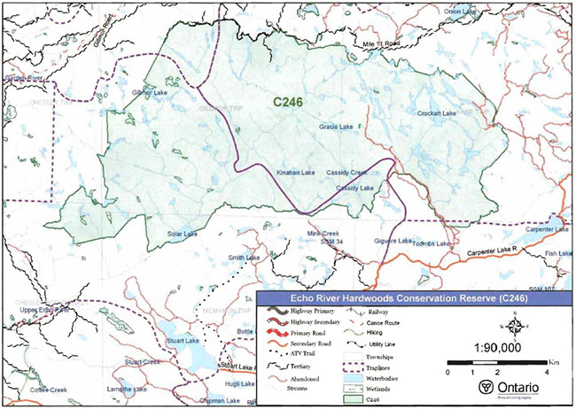
Enlarge Map 1: Recreational Values of Echo River Hardwoods Conservation Reserve
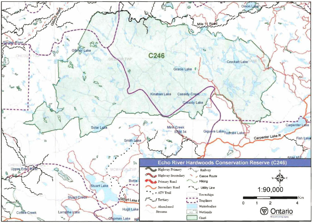
Map 2: Landforms in Echo River Hardwoods Conservation Reserve
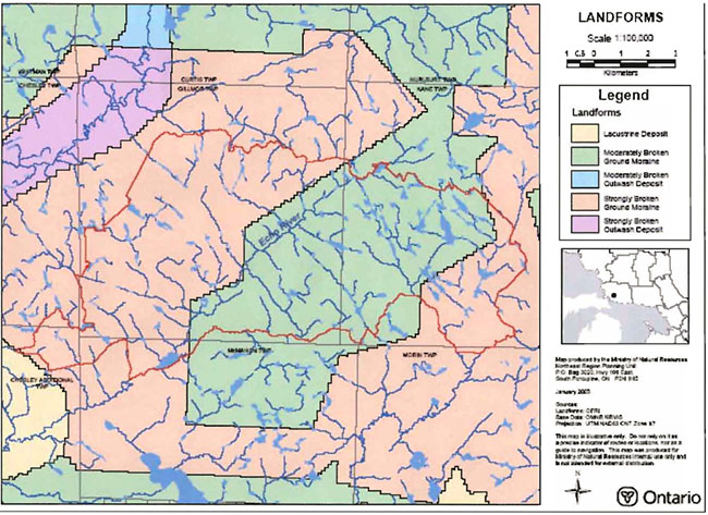
Enlarge Map 2: Landforms in Echo River Hardwoods Conservation Reserve
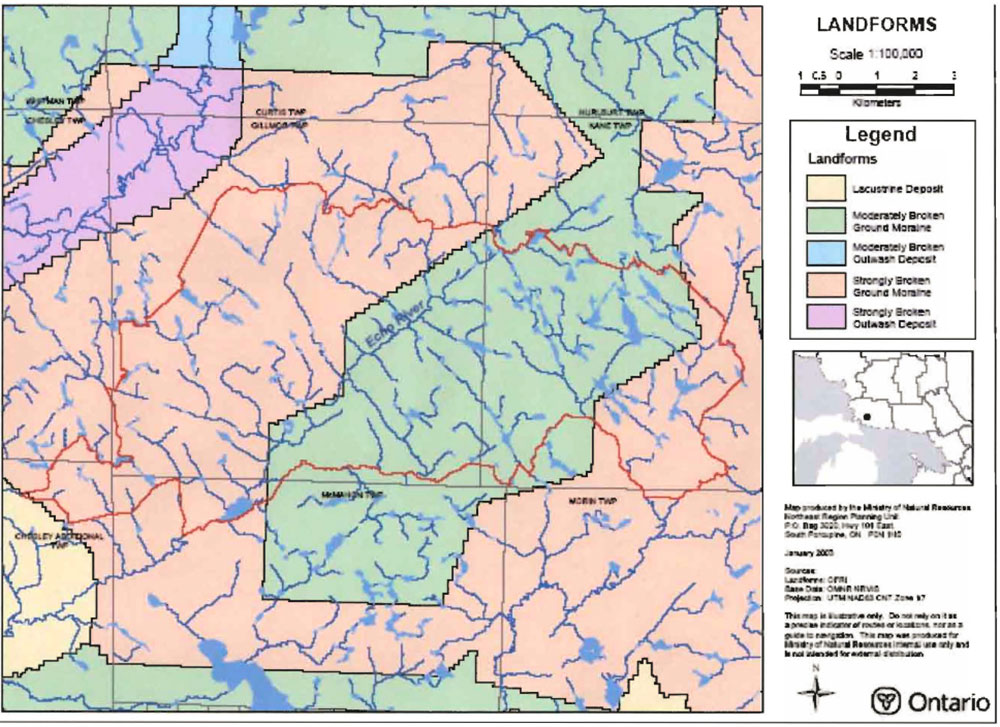
Map 3: Echo River Hardwoods Conservation Reserve Tree Soecies Comoosition
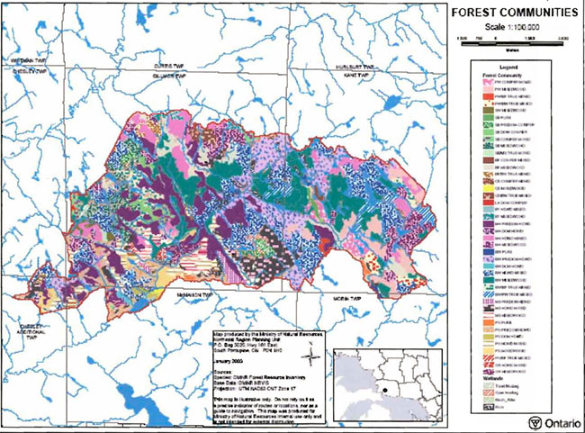
Enlarge Map 3: Echo River Hardwoods Conservation Reserve Tree Species Composition
Appendix B: Echo River Hardwoods Conservation Reserve photos
Photo 1: Upper Echo River, looking north.
(Photo taken by Derek Rice during site visit, OMNR; Sept. 2001)
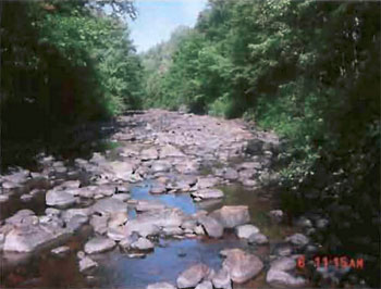
Photo 2: View looking north from ridge located south of Kinahan Lake.
(Photo taken by Gerry Morin during site visit, OMNR; Sept. 2001)
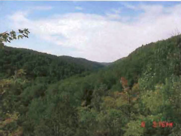
Photo 3: Southwest corner of Kinahan Lake with surrounding wetland.
(Photo taken by Gerry Morin during site visit, OMNR; Sept. 2001)
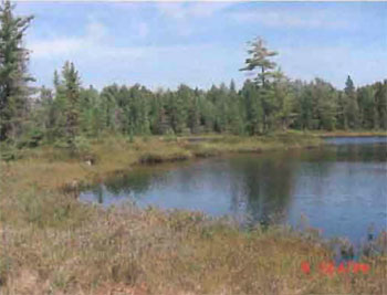
Photo 4: View looking southwest from ridge located south of Kinahan Lake.
(Photo taken by Gerry Morin during site visit, OMNR; Sept. 2001)
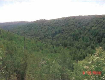
Photo 5: Swamp located close to the north-east boundary of conservation reserve.
(Photo taken by Neeta Nathwani during site visit, OMNR; 26 Sept. 2001)
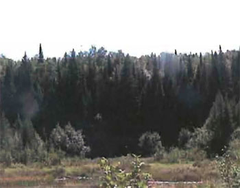
Photo 6: Southwest arm of Kinahan Lake, looking north.
(Photo taken by Gerry Morin during site visit, OMNR; Sept. 2001)
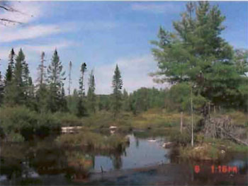
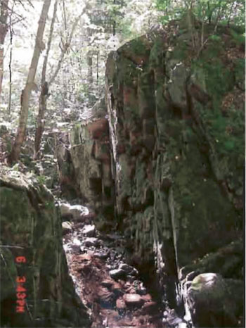
Photo 7: Rock chasm located south of Kinahan Lake.
(Photo taken by Gerry Morin during site visit, OMNR; 26 Sept. 2001)
Appendix C: Test of compatibility
Test of compatibility
The Conservation Reserve policy provides broad direction with regard to the permitted uses. The policy provides onlv an indication of the variety of uses that will be considered acceptable in conservation reserves. Any new uses, and commercial activities associated with them, will be considered on a case by case basis, and, subject to the following test of compatibility. To ensure a standard screening process is followed, reviews of all current and new activities will be subject to the screening criteria as specified by the Environmental Assessment Act (R.S.O. 1900, Chapter E.18).
The following outlines the two steps involved in performing a Test of Compatibility. An assessment of current activities would only follow step two, which focuses on the impacts. An assessment of any new activity would consider the impact of the activity and its conformity to the SCI/RMP.
-
Conformity to SCI/RMP: SCI describe values for which an area has been set aside and the range of appropriate uses that will be permitted in the area. SCI may also speak to the acceptability of other 'new' uses currently not occurring in the area.
The first 'test' is: "do proposed new land uses and/or commercial activities conform to the direction of the SCI/RMP for the conservation reserve? Would the new use(s) depart from the spirit of appropriate indicator land uses in the SCI/RMP?"
- Impact Assessment: If the proposed use(s) pass test 1 it is important to determine their impact on the area before they are approved. This should include the following:
- Impact on natural heritage values: "will the new use(s) impact any natural values in the area? If so how and to what degree? Is it tolerable?"
- Impact on cultural values: "will the new use(s) impact an historical or archaeological values in the area?"
- Impact on research activities: "will the new use(s) affect research activities in the area?"
- Impact on current uses: "will the new use(s) have any negative impact on the array of current uses?"
- Impact on area administration: "will the new use(s) increase administrative costs and/or complexity?" (For example, the cost of area monitoring, security and enforcement).
- Impact on accommodating the use outside the conservation reserve: "Could the use(s) be accommodated as well or better outside the conservation reserve?"
- Impact on socio-economics of the area: "will the new use(s) affect the community(ies) surrounding the area in a positive or negative way?" (For example, will the new use make an area less remote thereby affecting a local tourism industry that is dependent on the area’s remoteness for its appeal?"
- Impact on area accessibility: "does the new use(s) give someone exclusive rights to the area or a portion of the area to the exclusion of other existing uses?"
Appendix D: Summary of permitted uses
For the most recent version of this policy report,please refer to the Crown Land Use Atlas located on the internet at /page/crown-land-use-policy-atlas, or contact your local Ministry of Natural Resources Office.
Crown Land Use Atlas - Policy report
C246
Echo River Hardwoods
Updated: September 25, 2002
Identification:
ID: C246
Area Name: Echo River Hardwoods
Area (ha): 10,236
Designation: Conservation reserve (Ontario’s Living Legacy)
District(s): Sault Ste. Marie
Description:
The best example in Site District 4E-3 of extensive sugar maple dominated forests, ranging from 40 to 140 years old, growing on a landscape of steep hills with shallow sands and bare bedrock. A small number of young red maple stands, white birch stands and open rock outcrop communities are also found here. The headwaters of several tributaries of the Echo River are in this site.
Echo River Hardwoods was regulated as a conservation reserve on April 6, 2001.
Land use intent:
Management of this area is also governed by the general policies contained in the Land use Strategy (1999).
Management direction:
Those uses and management activities not listed in the following table ere governed by existing conservation reserve policy. Over time the management direction will be elaborated In a Statement of Conservation Interest or Resource Management Plan. Any new uses, and commercial activities associated with conservation reserves, will be considered on a case by case basis, and they must pass a test of compatibility to be acceptable. Compatibility is normally determined through a planning process.
Commercial activities
| Activity | Permitted | Guidelines |
|---|---|---|
| Aggregate Extraction: | No | |
| Bait Fishing Existing: | Yes | Existing use permitted to continue, unless there are significant demonstrated conflicts. New operations can be considered, subject to the "test of compatibility" |
| Bait Fishing New: | Maybe | |
| Commercial Fishing Existing: | Yes | Existing use permitted to continue, unless there are significant demonstrated conflicts. New operations can be considered, subject to the "test of compatibility". |
| Commercial Fishing New: | Maybe | |
| Commercial Fur Harvesting Existing: | Yes | |
| Commercial Fur Harvesting New: | Maybe | Existing use permitted to continue, unless there are significant demonstrated conflicts. Existing trap cabins can continue; new cabins are not permitted. New operations can be considered, subject to the "test of compatibility". |
| Commercial Hydro Development: | No | |
| Commercial Timber Harvest: | No | |
| Commercial Tourism Existing: | Yes | |
| Commercial Tourism New: | Maybe | Existing authorized facilities can continue, unless there are significant demonstrated conflicts. New tourism facilities can be considered during the planning for an individual reserve. |
| Bear Hunting by Non residents (guided) Existing: | Yes | Existing authorized operations permitted to continue. New operations not permitted. |
| Bear Hunting by Non residents (guided) New: | No | |
| Outfitting Services Existing: | Yes | Existing authorized operations permitted to continue. New operations can be considered during the planning for an individual reserve. |
| Outfitting Services New: | Maybe | |
| Outpost Camps Existing: | Yes | Existing authorized operations permitted to continue. New operations can be considered during the planning for an individual reserve. |
| Outpost Camps New: | Maybe | |
| Resorts/lodges Existing: | Yes | |
| Resorts/lodges New: | Maybe | Existing authorized facilities permitted to continue. New facilities can be considered during the planning for an individual reserve. |
| Energy Transmission and Communication Corridors Existing: | Yes | |
| Energy Transmission and Communication Corridors New: | No | These facilities should avoid conservation reserve lands wherever possible. |
| Food Harvesting (Commercial) Existing: | Maybe | |
| Food Harvesting (Commercial) New: | Maybe | |
| Mineral Exploration and Development: | No | |
| Peat Extraction: | No | |
| Wild Rice Harvesting Existing: | Yes | |
| Wild Rice Harvesting New: | Maybe |
Land and resource management activities
| Activity | Permitted | Guidelines |
|---|---|---|
| Crown Land Disposition Private Use: | Maybe | |
| Crown Land Disposition Commercial Use: | Maybe | Sale of lands is not permitted, except for minor dispositions in support of existing uses (e.g. reconstruction of a septic system). Renewals of existing leases and land use permits are permitted. Requests for transfer of tenure will be considered in the context of the Statement of Conservation Interest or Resource Management Plan. New leases or land use permits permitted for approved activities. Tourism facilities can apply to upgrade tenure from LUP to lease. |
| Fire Suppression: | Yes | Fire suppression policies are similar to adjacent Crown lands, unless alternative fire policies have been developed through a planning process. |
| Fish Habitat Management: | Maybe | |
| Fish Stocking: | Maybe | Conservation Reserved policy indicates that "featured species management" may be permitted. |
| Insect/disease Suppression: | Maybe | |
| Inventory/Monitoring: | Yes | |
| Prescribed Burning: | Maybe | |
| Roads (Resource Access) Existing: | Yes | |
| Roads (Resource Access) New: | Maybe | Existing roads can continue to be used. Continued use will include maintenance and may include future upgrading. New roads for resource extraction will not be permitted, with the exception of necessary access to existing forest reserves for mineral exploration and development. |
| Vegetation Management: | Maybe | Conservation Reserves policy indicates that Featured Species Management and Natural Systems Management may be permitted. Vegetation management can be considered in a planning process. |
| Wildlife Population Management: | Maybe |
Science, education and heritage appreciation
| Activity | Permitted | Guidelines |
|---|---|---|
| Collecting: | No | |
| Historical Appreciation: | Yes | |
| Nature Appreciation: | Yes | |
| Photography and Painting: | Yes | |
| Research: | Yes | |
| Wildlife Viewing: | Yes |
Recreation activities and facilities
| Activity | Permitted | Guidelines |
|---|---|---|
| All Terrain Vehicle Use On Trails: | Yes | |
| All Terrain Vehicle Use Off Trails: | No | Existing use permitted to continue where it does not adversely affect the values being protected. ATV use off trails is not permitted except for direct retrieval of game. |
| Campgrounds: | Maybe | |
| Food Gathering: | Yes | |
| Horseback Riding (trail): | Yes | Existing use on trails permitted. |
| Hunting: | Yes | |
| Mountain Bike Use: | Yes | Existing use on trails permitted. |
| Motor Boat Use Commercial: | Yes | |
| Motor Boat Use Private: | Yes | |
| Non-motorized Recreation Travel: | Yes | |
| Private Recreation Camps (Hunt Camps) Existing: | Yes | |
| Private Recreation Camps (Hunt Camps) New: | No | Existing camps permitted to continue, and may be eligible for enhanced tenure, but not purchase of land. |
| Rock Climbing: | Maybe | |
| Snowmobiling On Trails: | Yes | |
| Snowmobiling Off Trails: | Maybe | Existing use permitted to continue where it does not adversely affect the values being protected. Snowmobile use off trails is not permitted, except that snowmobiles may be used for direct retrieval of game. |
| Sport Fishing: | Yes | |
| Trail Development: | Maybe | Development of trails for a variety of activities (e.g. hiking, cross-country skiing, cycling, horseback riding, snowmobiling) can be considered as part of planning for an Individual reserve. |
Note: The policies outlined in this table do not supersede any Aboriginal or treaty rights that may exist, or other legal obligations.
Management of this conservation reserve is carried out within the context of Conservation Reserve policy as amended by the policies for new conservation reserves outlined in the Ontario’s Living Legacy Land Use Strategy.
Source of direction:
Ontario’s Living Legacy, Land Use Strategy (1999)
Conservation Reserves Policy (1997)
Blind River District Land Use Guidelines (1983)
Explanation of Edits:
Appendix E: Regulation public consultation material
September 1, 2000
To: Ontario Living Legacy stakeholders
Dear Sir/Madam:
On July 16, 1999, the Ontario Government released the Ontario’s Living Legacy Land Use Strategy, a broad land use approach to the planning and management of much of the Crown lands in central and parts of northern Ontario. A major part of the Ontario’s Living Legacy Land Use Strategy was a government commitment to the biggest expansion of provincial parks and conservation reserves in Ontario’s history. Ontario intends to add 378 new areas to its protected areas system. Ontario’s Living Legacy is a momentous achievement that will be recognized around the world as a significant contribution to sustaining our natural environment. A copy of the Land Use Strategy is available from our office upon request.
In accordance with the recommendations in the Land Use Strategy, the Ministry of Natural Resources (MNR) is now implementing the process of establishing these 378 new protected areas. The first step in this process is for the Ministry to consult on the boundaries of these areas. In November 1999, the MNR held boundary consultations on 64 sites across the OLL Planning Area. Eight of these sites were within Sault Ste. Marie District. At this time, Sault Ste. Marie District has prepared 19 more sites for boundary refinement consultation. Adjacent Districts are consulting an additional two sites, which are also partially contained within Sault Ste. Marie District, on. In future years, the remaining recommended protected areas from the Land Use Strategy will be put forward for similar consultations.
As stated in the Land Use Strategy, the boundary refinement process will consider local ecological information and will attempt to establish regulated boundaries along features that can be identified on the ground. The boundary refinement process may result in modest increases or decreases in the sizes of the protected areas. Any existing commitments for the areas, which were considered during the land use planning process, will be considered in defining the final boundary.
Following is a list of the 21 sites in SSM District scheduled for boundary consultation this year. These sites include both provincial parks and conservation reserves. The Land Use Strategy established the Ministry’s intent to add these Crown lands to Ontario’s protected areas system, following the extensive public consultation associated with Ontario’s Living Legacy and the Lands for Life land use planning initiatives between 1997 and 1999. The Ministry is inviting public comment on the proposed boundaries of these protected areas prior to their finalization and ultimate regulation under the Provincial Parks Act or the Public Lands Act.
- C227 - Glen Crombie Conservation Reserve
- P238 - Mississagi River Provincial Park Additions
- C243 - Wagong Lake Forest Conservation Reserve
- C244 - Rawhide Lake Conservation Reserve
- C246 - Echo River Hardwoods Conservation Reserve
- C247 - Byrnes Lake White Birch Conservation Reserve
- P253 - Goulais River Provincial Park
- C256 - Basswood Lake Hemlock Conservation Reserve
- C258 - Thessalon River Delta/Rock Lake Red Oak Conservation Reserve
- C260 - Rose Lake Dune Peatland Complex Conservation Reserve
- C262 - Stuart Lake Wetland Conservation Reserve
- P273 - Algoma Headwaters Provincial Park
- P274 - Wenebegon River Provincial Park
- P277 - Aubinadong - Nushatogaini Rivers Provincial Park
- P278 - Pancake Bay Provincial Park Additions
- P282 - Batchawana River Provincial Park
- P285 - Sandy Islands Provincial Nature Reserve
- C289 - Searchmont South Forest Conservation Reserve
- C291 - Goulais River Beach Ridges Conservation Reserve
- P292 - Lake Superior Provincial Park Additions
- C307 - Iie Parisienne Conservation Reserve
Your name and address have been included within a Ministry mailing list of persons potentially interested in these boundary consultations. The mailing list includes a range of individuals and groups, such as nearby landowners, resource users, persons with other rights or tenure (e.g. land use permit, Mining Act rights), municipalities, and others who may have an interest in the area. Accompanying this letter, you will find background information (factsheets, maps) for the site(s) we have determined to be of interest to you. More detailed maps and information about the proposed boundaries for all 21 sites are available from this office, or from the Blind River Area Office, 62 Queen Ave., Blind River.
In the future and subject to the intended regulation of these areas as provincial parks and conservation reserves, Ontario Parks and the Ministry of Natural Resources will undertake a management planning process to determine the long-term management of these protected areas. Depending upon the complexity of issues related to the provincial parks, management planning may take the form of a simple Interim Management Statement or a more detailed Park Management Plan. In the case of planning for conservation reserves, a simple Statement of Conservation Interest or a more detailed Resource Management Plan will result. Please let us know if you would like to be notified when planning begins.
Planning, management and permitted uses within these provincial parks and conservation reserves would be consistent with the commitments of the Ontario’s Living Legacy Land Use Strategy.
The Ministry is collecting comments and information regarding these proposed provincial park and conservation reserve boundary reviews under the authority of the Provincial Parks Act and the Public Lands Act respectively. These comments will assist the Ministry in making decisions and determining further public consultation needs. Comments and opinions will be kept on file and may be included in study documentation that is made available for public review. Under the Freedom of Information and Protection of Privacy Act (1987), personal information will remain confidential unless prior consent is obtained. However, the Ministry may use this information as public input on other resource management surveys or projects. For further information regarding this Act, please contact Paul Glassford, Ninformation Management Supervisor, Ministry of Natural Resources, Sault Ste. Marie District ( 705-949-1231).
If you would like to discuss the proposed boundaries and the protection of these areas under the Provincial Parks Act and/or the Public Lands Act, please contact Erin Nixon, District Planner, Ministry of Natural Resources, 64 Church Street, Sault Ste. Marie, Ontario, P6A 3H3; telephone 705-949-1231 ext. 247, fax 705-949-6450, by October 6, 2000. Further information on Ontario’s Living Legacy is available in our office or by visiting the Ministry’s internet website at www.ontario.ca.
Thank you for your interest.
Yours sincerely,
Dick Hagman
A/District Manager
Sault Ste. Marie District
DH/sw
Attachments-
Provincial Park and/or Conservation Reserve Factsheet(s)
Proposed Site Boundary Map(s)
Key Map
Permitted Uses Table(s) for Provincial Parks and/or Conservation Reserves
On peut obtenir Ia version fran ise de Ia presente lettre en s'adressant au bureau du MRN le plus proche, a l'adresse ou au numero de telephone ci-dessous.
Qntario’s Living Legacy
Echo River Hardwoods Conservation Reserve (C246) fact sheet
September, 2000
Background
On July 16, 1999, the Ontario Government released the Ontario’s Living Legacy Land Use Strategy to guide the planning and management of Crown lands in central and parts of northern Ontario. A major part of the Ontario’s Living Legacy Land Use Strategy was a government intent to establish 378 new protected areas. This commitment marks the biggest expansion of provincial parks and conservation reserves in Ontario’s history.
The proposed Echo River Hardwoods Conservation Reserve is part of this significant expansion of Ontario’s protected areas system. Following public and First Nations consultation in late 2000 and early 2001 on refining the boundary on this protected area, Ontario Regulation 805/94 of the Public Lands Act was amended on April 6, 2001 by Ontario Regulation 86/01, to formally establish this conservation reserve.
Size and location
The Echo River Hardwoods Conservation Reserve is located approximately 35 km east of the City of Sault Ste. Marie. The reserve encompasses approximately 10,244 ha of forested land in Gillmor, Kane, McMahon and Chesley Additional Townships. It is bisected by the Upper Echo River.
Area highlights
The Conservation Reserve is located within ecological Site District 4E-3, an ecological unit extending roughly from Gogama and Chapleau in the north to Sudbury and Elliot Lake in the south. Located on the Canadian Shield, Site District 4E-3 is characterized by a rocky landscape dissected by numerous folds and faults. Vegetation communities within this site district are best described as heterogeneous owing to the mix of northern and southern species that occur here. Fire has been an important influence on the vegetation in the past, particularly with regard to the perpetuation of pines.
The Echo River Hardwoods, a provincially significant site, is the best example in Site District 4E-3 of extensive sugar maple dominated forests growing on a landscape of steep hills with shallow sands and bare bedrock. These stands range in age from 40 to 140 years, and are interspersed with a small number of young red maple stands, white birch stands and open rock outcrop communities.
The headwaters of several tributaries of the Echo River occur within the site, while Crockatt Lake and associated ponds form a small watershed that ultimately feeds the Thessalon River system. Due to the remote nature of this conservation reserve, harvesting appears to have occurred mainly in areas beyond the site’s boundaries.
Land use intent
Conservation reserves are areas of Crown land set aside by regulation under the Public Lands Act. Conservation reserves complement provincial parks in protecting representative natural areas and special landscapes. Most recreational (e.g. hiking, skiing, tourism related uses, nature appreciation) and non-industrial (e.g. fur harvesting, commercial fishing and bait harvesting) activities that have traditionally been enjoyed in the area will continue, provided that these uses do not impact on the natural features needing protection. Hunting and fishing are also permitted within all new conservation reserves recommended through Ontario’s Living Legacy.
Commercial timber harvesting, mining, aggregate extraction and commercial hydroelectric development are prohibited in conservation reserves. Careful mineral exploration may occur in specific new conservation reserves proposed through Ontario’s Living Legacy, in areas that have provincially significant mineral potential. If a portion of a new conservation reserve is to be developed for a mine, it would be removed from the reserve, and appropriate replacement lands would be placed in regulation. Please refer to Table 4 from the Land Use Strategy for a detailed summary of permitted uses in conservation reserves.
Next steps
The Land Use Strategy established the Ministry’s intent to add these Crown lands to Ontario’s protected areas system, following the extensive public consultation associated with the Ontario’s Living Legacy and Lands for Life land use planning initiatives between 1997 and 1999. Prior to the finalization of the boundary of this conservation reserve, proposed for regulation under the Public Lands Act, the Ministry is inviting public comment on the proposed boundary from all potentially affected stakeholders and First Nations from September 1 to September 30, 2000.
In the interim, the area has been withdrawn and protected from resource extraction activities such as timber harvesting, hydroelectric development, aggregate extraction and new mineral exploration.
In the future and subject to the intended regulation of the area as a conservation reserve, the Ministry of Natural Resources will prepare a long term management plan for this area. Depending upon the complexity of issues within this conservation reserve, management planning may take the form of a simple Statement of Conservation Interest or a more detailed Resource Management Plan. Please let us know if you would like to be notified when planning begins.
Planning, management and the uses permitted within this conservation reserve will be consistent with the commitments of the Ontario’s Living Legacy Land Use Strategy.
For More Information
For further information on the proposed Echo River Hardwoods Conservation Reserve, please contact Erin Nixon, District Planner, Ministry of Natural Resources, Sault Ste. Marie District ( 705-949-1231 ext. 247). You may also visit the Ministry’s internet website at www.ontario.ca for information about Ontario’s Living Legacy.
64 Church Street
Sault Ste. Marie, ON
P6A 3H3
August 22, 2001
Regulation of Ontario’s Living Legacy Protected Areas in Sault Ste. Marie- District
In July 1999, the Ontario Government released the Ontario’s Living Legacy Land Use Strategy, a broad land use approach to the planning and management of Crown lands in central and parts of northern Ontario. A large component of the Ontario’s Living Legacy Land Use Strategy was a government commitment to add 378 new provincial parks and conservation reserves to Ontario’s protected areas system.
In November 1999 and again in September 2000, we provided you with the opportunity to comment on the proposed boundaries for the park and the conservation reserves in Sault Ste. Marie District. I am pleased to inform you that, as of January 2001, the park and fifteen of these conservation reserves have been regulated. The new park and conservation reserves in the District are:
- P285 Sandy Islands Provincial Nature Reserve
- C243 Wagong Lake Forest Conservation Reserve
- C244 Rawhide Lake Conservation Reserve
- C245 Jollineau Conservation Reserve Conservation Reserve
- C246 Echo River Hardwoods Conservation Reserve
- C258 Thessalon River Delta/Rock Lake Red Oak Conservation Reserve
- C260 Rose Lake Dune Peat/and Complex Conservation Reserve
- C262 Stuart Lake Wetland Conservation Reserve
- C263 Garden Lake Forest Conservation Reserve
- C281 Tilley Creek West Conservation Reserve
- C284 Wabos North Conservation Reserve
- C286 Wabos South Conservation Reserve
- C289 Searchmont South Forest Conservation Reserve
- C294 O'Connor Conservation Reserve
- C298 Harmony Forest Conservation Reserve
- C307 Ile Parisienne Conservation Reserve
Regulation means the park and conservation reserves are now legally mapped and recognized as protected areas of crown land under the jurisdiction of the provincial government. As such, these areas will be protected from industrial activities, including commercial forestry, hydroelectric development, mining, and aggregate and peat extraction. Traditional recreational and resource uses such as hunting, fishing, hiking, canoeing, boating, and fur trapping, will generally be permitted to continue within the conservation reserves. In nature reserve class provincial parks (eg. P285, Sandy Islands), hunting and fur trapping are not permitted; other traditional recreational uses (fishing, hiking, canoeing, boating) may continue.
Ontario Parks staff is responsible for the planning and management of Sandy Islands Provincial Nature Reserve and they will prepare an Interim Management Statement to guide the management of this property. Sault Ste. Marie District is responsible for the management of the conservation reserves and will develop Statements of Conservation Interest (SCI) to guide the management of each new conservation reserve. There will be opportunity for the public to review and comment on draft SCIs for each conservation reserve. Depending upon the complexity of issues related to the sites and their management, more detailed Management Plans may, in due course, be required.
Detailed maps of the regulated boundaries for these new protected areas are available for viewing in the Sault Ste. Marie District office and the Blind River Area office of the Ministry of Natural Resources.
If you have any questions or concerns about the management of Sandy Islands Provincial Nature Reserve, please contact Chris Caldwell, Ontario Parks at the Sault Ste. Marie District Office. Concerns regarding any of the conservation reserves, should be addressed to Sheila Walsh (OLL Resource Planner) also at the Sault Ste. Marie District Office.
Thank you for your interest in Ontario’s Living Legacy.
Yours truly,
Tom Mispel-Beyer
A/District Manager
Sault Ste. Marie District
Telephone: 705-949-1231
Facsimilie: 705-949-6450
E-mail: tom.mispelbeyer@mnr.gov.on.ca
TMB/gm
Appendix F: Amendments to the SCI
Footnotes
- footnote[1] Back to paragraph Stand stocking is defined as follows: a qualitative measure of the density of tree cover in a forest stand. Stocking represents the density of forest stems based on average age, height, and the working group (the dominant tree species) in a forest stand (OMNR 2001).