
Forest fires
Find information about the current danger, activity and fire restrictions of forest fires and grass and brush fires across Ontario.
Restricted Fire Zone in effect
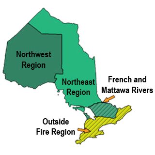
A Restricted Fire Zone (RFZ) is in effect for the Northwest Region and a small portion of the Northeast Region. Learn more about the current RFZ boundaries and restrictions.
Report a fire
To report a wildland fire (including grass, brush and forest fires) call
South of the French and Mattawa rivers call 911.
Call or text 2-1-1
Ontarians impacted by wildland fires can call or text 2-1-1 or visit 211ontario.ca to get non-emergency info about available supports and services.
Interactive fire map
Real time updates.
Our interactive map visually shows active fires, current fire danger across the province and restricted fire zones in effect.
The map now shows perimeters for some fires over 40 hectares in size. Note that not all fires are mapped and perimeters are not updated every day (may differ from the size reported in the table).
Most of the data used in the Interactive Map is available on Ontario GeoHub.
We recommend using Google chrome as your web browser to access the map.
Ontario's fire season starts April 1
Aviation, Forest Fire and Emergency Services reminds the public that outdoor fire rules are in effect throughout Ontario’s legislated fire season, which runs from April 1 to October 31. To dispose of yard waste and woody debris, we encourage the use of alternatives such as composting or utilizing your local landfill. If you must burn, use caution and follow the rules outlined in Ontario’s Wildland Fire Management regulation.
Fires are to be ignited no sooner than 2 hours before sunset and extinguished no later than 2 hours after sunrise. Always ensure you have adequate tools and water available to contain the fire at the site. Know the rules for safe outdoor burning. Read the full set of outdoor fire rules.
Residents within municipal boundaries must also check with their local fire department for burning restrictions or permitting requirements prior to burning.
Wildland Fire Management Act
Effective April 1, several regulatory changes come into effect as a result of updates to the Wildland Fire Management Act. These amendments will help to ensure greater awareness of rules designed to prevent unwanted human-caused fires and include:
- A new Ontario Regulation 44/26 (Administrative Penalties) to establish a framework for issuing administrative monetary penalties for contraventions of the Act or its regulations, generally before a wildland fire has occurred.
- Replacing the Outdoor Fires regulation with the Ontario Regulation 43/26 (Wildland Fire Management) to clarify, streamline, and reduce permit requirements.
- Amendments to the existing cost recovery regulation.
- Updates to short form wordings in an existing regulation.
These amendments will help modernize wildland fire management and protect Ontario communities throughout current and future wildland fire seasons. To learn more about the updates now in effect, keep an eye out for our social media posts this month or visit the Wildland Fire Management Act webpage found on e-Laws.
Learn more about the regulations.
- Ontario Regulation 44/26 (Administrative Penalties)
- Ontario Regulation 43/26 (Wildland Fire Management)
Forest fire updates
Northeast Region
Updated: August 1, 2026 at 6:00 p.m. Eastern Daylight Time (EDT)
One new wildland fire was confirmed in the Northeast Region today:
- Cochrane 49 (COC049) is 350 hectares and located approximately 50 kilometres north of Pledger Lake and 42 kilometres northwest of Jaab Lake. The fire is being observed.
There are currently 45 active wildland fires in the Northeast Region. Of these fires: 3 are not under control, 4 are being held, 4 are under control and 34 are being observed.
To access the current forest fire danger rating in your area visit our interactive fire map.
Northwest Region
Updated: August 1, 2026 at 6:50 p.m. Central Daylight Time (CDT)
There were 8 new wildland fires confirmed in the Northwest Region by the evening of August 1.
- Sioux Lookout 111 (SLK111) is located near Sunlight Lake, approximately 15 kilometers north of Lac Seul. The 0.1-hectare fire is under control.
- Sioux Lookout 112 (SLK112) is located north of Schist Lake, approximately 7 kilometers north of Highway 516. The 1.5-hectare fire is not under control.
- Fort Frances 57 (FOR057) is located near Mang Lake, approximately 4 kilometers northwest of Highway 502. The 0.1-hectare fire is not under control.
- Fort Frances 58 (FOR058) is located between Konigson Lake and Calder Lake. The 0.1-hectare fire is not under control.
- Dryden 60 (DRY060) is located north of Buller Lake, approximately 8 kilometres east of Highway 105. The 0.2- hectare fire is being held.
- Dryden 61 (DRY061) is located near Rafter Lake approximately 9 kilometers west of Highway 72. The 0.1-hectare fire is under control.
- Thunder Bay 70 (THU070) is located in Wabakimi Park, approximately 1 kilometer west of Beagle Lake. The 0.7-hectare fire is not under control.
- Nipigon 88 (NIP088) is located approximately 24 kilometers southwest of Sebert Lake. The 0.3-hectare fire is being observed.
At the time of this update there are 130 active wildland fires in the Northwest Region. Of those fires, 30 are not under control, 10 are being held, 5 are under control 85 are being observed.
To access the current forest fire danger rating in your area visit our interactive fire map.
Fires of note
The Rinker Complex Thunder Bay 36 (THU036), Dryden 34 (DRY034), Dryden 35 (DRY035), and Thunder Bay 54 (THU054)
- An Incident Management Team has assumed command of the Rinker Lake Complex on July 30.
- 14 wildland firefighting crews from Ontario and Alberta, a 20-person crew of wildland firefighters from Mexico are assigned to the complex.
- The Rinker Lake Complex fires have exhibited an increase in fire behaviour over the past few days.
- THU036 is currently measuring 313,930 hectares and is not under control.
- Aerial suppression efforts continue, while ground crews extinguish hot spots. These coordinated efforts are focused on securing the fire perimeters.
- Heavy equipment operators are constructing fire guards to create gaps in forest fuels, helping to limit fire spread and support containment efforts.
- Two Alberta Wildland Urban Interface (WUI) teams have been working on values protection.
- DRY034 is currently measuring 44,954 hectares and remains not under control.
- DRY035 is currently measuring 30,758 hectares and remains not under control.
- A narrow section of the southwestern perimeter of Thunder Bay 54 has now merged with the northern flank of Dryden 35. Please note that these two fires have become one, they will retain the name Dryden 35.
Atikokan Cluster - Fort Frances 13 (FOR013), Fort Frances 14 (FOR014), Fort Frances 15 (FOR015), Fort Frances 38 (FOR038)
- An additional group of wildland fire fighters from Mexico arrived, were briefed and placed on the fire line to join operations on August 1.
- The Atikokan Cluster of fires added Fort Frances 13, a monitored fire in Quetico Park approximately 6 kilometres south of the southernmost perimeter of Fort Frances 15. The fire is 25,279 hectares in size. Its control status is ‘being observed’.
- Carefully coordinated with flight operations, an Aviation Forest Fire and Emergency Services Remotely Piloted Aircraft System (RPAS) Unit are using a drone to scan for hot spots on FOR038 and FOR014 near Baril Lake. High level scans with fixed-wing aircraft are ongoing as weather permits.
- FOR014 has been more accurately remapped to a slightly smaller size of 51,768 hectares.
- Firefighting crews are working from multiple locations along the fire perimeter, using a pump-and-hoseline system and working towards one another.
- Helicopters continue to support suppression efforts by dropping water on hotspots and moving crews and equipment
- FOR015 is currently measuring 42,273 hectares and remains not under control.
- Crews are busy on the north side of FOR015 where fire behaviour has been more active as fuels dry out in the hot weather. Bucketing support from the helicopters is allowing the crews to make good progress in this area of the fire.
- FireRanger Crews on the west side of FOR015 continue to establish and consolidate hose line, patrol the established hoselines and are working inward to approximately 100 feet from the perimeter.
- FOR038, north of Crystal Lake, remains under control at 44.2 hectares in size.
- One crew is working to extinguish remaining hotspots identified by low-level infrared scanning.
Dryden 36 – Upper and Lower Moosehide Lakes
- The fire is now being held at 1,710 hectares.
- This change in status indicates that with currently committed resources, sufficient suppression action has been taken so that the fire is not likely to spread beyond existent or predetermined control boundaries under prevailing or forecasted conditions.
- Ontario FireRangers and Type-2 crews continue suppression efforts alongside bucketing helicopters.
- Low fire behaviour has observed in recent days under favourable weather conditions.
- 20 wildland firefighters from Mexico have arrived on the fire line to help with operations.
Sioux Lookout 72 – Cat Lake First Nation
- Today is the last day that Sioux Lookout 72 (SLK072) will appear as a fire of note.
- The fire is currently measuring 23,597 hectares and is not under control.
- FireRanger crews are making good progress on suppression efforts supported by bucketing helicopters targeting hotspots.
- Hand-held and aerial infrared scanning is being utilized to identify remaining hotspots.
- Minimal fire behaviour was observed today.
Highway 599 Cluster – Sioux Lookout 84 (SLK084), Sioux Lookout 86 (SLK086), Sioux Lookout 89 (SLK089)
- There has been no fire recent growth observed on cluster of fires.
- There are currently 118 personnel assigned to the incident, supported by five helicopters.
- Across all 3 fires, firefighters are using hand tools, pumps, and hose to extinguish remaining sources of heat.
- Crews continue to extinguish hotspots found by infrared scanning aircraft.
- SLK084 is currently measuring 4,796.6 hectares and remains not under control.
- SLK086 is currently measuring 5,644 hectares and remains not under control.
- SLK089 is currently measuring 7,190.1 hectares and remains not under control.
Evacuation Orders
Evacuation Order - Dryden 36
- All persons must immediately evacuate the area indicated on the attached map unless authorized by an exemption permit issued by the Ministry of Natural Resources.
- All persons are prohibited from entering the area indicated on the attached map unless authorized by a exemption permit issued by the Ministry of Natural Resources.
Review the Evacuation Order Map here.
This order is in effect as of July 23, 2026, at 07:01 Central Daylight Time until such time the order is revoked.
For more information on this Evacuation Order, please call
Evacuation Order - Thunder Bay 36, 54 & 56 and Dryden 34 & 35
- All persons must immediately evacuate the area indicated on the attached map unless authorized by an exemption permit issued by the Ministry of Natural Resources.
- All persons are prohibited from entering the area indicated on the attached map unless authorized by a exemption permit issued by the Ministry of Natural Resources.
Review the Evacuation Order Map here.
This Order is in effect as of July 20, 2026 at 07:00 a.m. Eastern Daylight Time until such time as the order is revoked.
For exemption permit information, please call
*Due to the high volume of calls, a representative from the MNR Thunder Bay - Ignace District will return your call as soon as possible.
To support evacuees, a reception centre is open at Fort William Gardens Arena, located at 901 Miles St E, Thunder Bay.
The centre includes sleeping accommodations, food, water, hygiene kits, and medical supports.
Implementation Orders
Restrictions in effect - Dryden 36
The Ministry of Natural Resources’ Dryden - Fort Frances - Atikokan District has invoked an Implementation Order now in effect for the purposes of public safety and fire suppression, for areas near Dryden 36, under the Emergency Area Order EAO 2026-009 declared on July 15, 2026.
- All travel and use of Berglund Road, Ila Road, Moosehide Road, Powerline Road as outlined in the identified area on the attached Implementation Order map within the EAO is prohibited unless authorized by a permit to engage in specified activities issued by the Thunder Bay-Ignace District of the Ministry of Natural Resources (MNR).
- All modes of travel/access into Balmoral River, Bigwalk Lake, Elsie Lake, Nora Lake, Roberts Lake, Turtle River and all Crown lands as outlined in the identified area on the attached Implementation Order map within the EAO is prohibited unless authorized by a permit to engage in specified activities issued by the Thunder Bay - Ignace District of the MNR.
Review the Implementation Order Map here.
This Order is in effect as of July 23, 2026, at 07:01 Central Daylight Time until such time as the order is revoked.
For more information on this Implementation Order, please call
Restrictions in effect - Thunder Bay 36, 54 & 56 and Dryden 34 & 35
The Ministry of Natural Resources’ Thunder Bay - Ignace District has invoked an Implementation Order for the purposes of public safety and/or effectual fire suppression, for areas near Thunder Bay 36, 54 & 56 and Dryden 34 & 35. Under the Emergency Area Order EAO 2026-009 declared on July 15, 2026.
All travel and use of as outlined in the identified area on the attached Implementation Order map within the EAO is prohibited unless authorized by a permit to engage in specified activities issued by the Thunder Bay-Ignace District of the Ministry of Natural Resources (MNR). These include:
- Armistice Rd
- Banksian Road
- Bert Road
- Black Sturgeon Road
- Block 455
- Block 458
- Block Road 11
- Brightsand Road
- Cedar Rapids Road
- Chappelle Road
- Cheek Road
- Cheeseman Road
- Chief Bay Road
- Dog River Road
- Dolly Road
- Empire Loop Road
- Flash Road
- Geikie Loop Road
- Geikie Road
- Glauca Road
- Graham Road
- Gull Road
- Haas Road
- Harry Road
- Hawkowl Road
- Heaven Road 400 North
- Highway 527
- Highway 811
- Jackfish Road
- Kab Road
- Mack Road
- Mack Station Road
- Main Graham Road
- Mcgee Road
- Mile 82 Road
- Mirror Road
- Moberly Lake Road
- Mug Lake Road
- Net 01 (Whalen)
- Numac Road
- Obonga North Road
- Pakashkan Road
- Poshkokagan Access Point
- Railbed Road
- Rd 175
- Rd 570
- Road 1
- Road 180
- Robin Road
- Rondeau Road
- Sideen Road
- Slingshot Road
- South Alley Road
- Sparrow Road
- Tib Road
- Tower Road
- Weaver Road
- Whiddon Road
- Whistle Road
- Willard Road
All modes of travel/access into and all Crown lands as outlined in the identified area on the attached Implementation Order map within the EAO is prohibited unless authorized by a permit to engage in specified activities issued by the Thunder Bay - Ignace District of the MNR. These include:
- Allely Creek
- Aylsworth Creek
- Bad Medicine Lake
- Brightsand River
- Caribou Lake
- Caribou River
- Collaton Lake
- Dazzle Creek
- Dog River
- Duck Creek
- Fallscamp Creek
- Gnome Lake
- Gull River
- Harmon Lake
- Harry Creek
- Heaven Creek
- Hogarth River
- Kabitotikwia River
- Kashishibog River
- Kenna Creek
- Kopka River
- Lake Nipigon
- Little Jackfish River
- Lookout River
- McConnell Creek
- Mojikit Lake
- Moule Lake
- Pikitigushi River
- Poshkokagan River
- Raymond River
- Ricestalk Creek
- Scallop Lake
- Secord Lake
- Seymour Creek
- Shawanabis Lake
- Slant Creek
- South Summit Lake
- Stork Lake
- Wabikon Creek
- Wabinosh River
- Wapikaimaski Lake
- Whitesand River
- Wolf Creek
- Yoho Creek
- Zigzag Lake
Review the Implementation Order map here
This Order is in effect at 12:01 a.m. Eastern Daylight Time on July 20, 2026 until such time as the order is revoked.
For more information on this Implementation Order, please call
Updated restrictions in effect - Fort Frances 14
The Ministry of Natural Resources’ Thunder Bay – Ignace District has invoked an Implementation Order now in effect for the purposes of public safety and fire suppression, for areas near Fort Frances 14, under the Emergency Area Order EAO 2026-009 declared on July 15, 2026.
All travel and use of roads and watercourses as outlined in the identified area on the below Implementation Order map within the EAO are prohibited unless authorized by a permit to engage in specified activities issued by the Thunder Bay-Ignace District of the Ministry of Natural Resources (MNR). This includes All road-accessible lands and all travel and use of all watercourses situated:
- south of Sapawe Road, commencing at the point where Sapawe Road intersects the western boundary of the Territorial District of Thunder Bay; thence easterly along Sapawe Road and continuing along Highway 17, following the western and southern boundaries of Upsala Township; thence easterly along Highway 17 to the eastern boundary of Savanne Township; thence southerly along the eastern boundary of Savanne Township to its intersection with Lac des Mille Lacs (Sawmill Bay); thence southerly along the eastern shoreline of Lac des Mille Lacs (Sawmill Bay) to its intersection with the “Height-of-Land” Portage Route; thence southerly to the eastern shoreline of Kashabowie Lake; thence westerly along the eastern and northern shoreline of Kashabowie Lake to the point of effluence of Crayfish Creek; thence easterly along the northern shore of Crayfish Creek to its intersection with the Canadian National Railway right-of-way; thence westerly along the northern limit of the Canadian National Railway right-of-way to its intersection with the western boundary of the Territorial District of Thunder Bay; thence northerly along the western boundary of the Territorial District of Thunder Bay to its intersection with Sapawe Road, being the point of commencement.
This Order is in effect as of August 01, 2026 at 07:01 Eastern Daylight Time until such time as the order is revoked.
For more information on this Implementation Order, please call
Evacuation Alerts
Evacuation Alert - Fort Frances 13
An evacuation alert has been issued in the Saganaga Lake area by Thunder Bay-Ignace District due to the evolving situation and increased fire behaviour of wildland fire Fort Frances 13 (also known as "Little Knife" fire in Minnesota). People residing in or utilizing the area near the fire, located within Ontario, are strongly encouraged to prepare to evacuate on short notice.
Review the Evacuation Alert Map here.
Please plan ahead and stay connected:
- Make sure you are aware of the current fire situation
- Prepare an emergency bag with your essentials (medicine, passports, legal documents etc.)
- Monitor official channels for updates at ontario.ca/fireupdates
- Be ready to quickly leave if instructed
- Respect evacuation orders, road closures and public officials' direction
- Give crews and aircraft ample space to work
This alert is in effect as of July 24, 2026 at 9:00 a.m. Central Daylight Time until such time as the alert is canceled.
For more information on this evacuation alert, please call
Evacuation Alert - Fort Frances 39 & Minnesota’s ‘Thumb Fire’
An evacuation alert has been issued by Dryden Fort Frances Atikokan District due to the evolving situation and increased fire behaviour of wildland Fire Fort Frances 39 and Minnesota’s ‘Thumb Fire’. People residing or utilizing the area near the fires, located within Ontario, are strongly encouraged to prepare to evacuate on short notice.
This includes all areas accessed by:
- Lagoon Road
And all areas located on the following lakes:
- Blue Lake
- Cranberry Lake
- Lac La Croix
- Lilac Lake
- Loon Lake
- Queer Rock Lake
- Spring Lake
- Thompson Lake
- Trout Lake
Please plan ahead and stay connected:
- Make sure you are aware of the current fire situation
- Prepare an emergency bag with your essentials (medicine, passports, legal documents etc.)
- Monitor official channels for updates at ontario.ca/fireupdates
- Be ready to quickly leave if instructed
- Respect evacuation orders, road closures and public officials' direction
- Give crews and aircraft ample space to work
For more information on this evacuation alert, please call
NOTAM - Thunder Bay 36
There is currently a NOTAM in the area of wildland fire Thunder Bay 36.
This is over and above the standard airspace restrictions imposed by Section 601.15 of the Canadian Aviation Regulations (CARs) which state that the airspace around all active forest fires is restricted to forest fire suppression aircraft only, specifically airspace within 5 nautical miles, up to an altitude of 3000 feet above ground level.
Pilots are reminded that NOTAMs concerning forest fires can be found on NavCanada’s Collaborative Flight Planning Services under the ‘Weather and NOTAM’ tab, when flight planning.
NOTAM - Fort Frances 14
There is currently a NOTAM in the area of wildland fire Fort Frances 14, northeast of Byers Lake.
This is over and above the standard airspace restrictions imposed by Section 601.15 of the Canadian Aviation Regulations (CARs) which state that the airspace around all active forest fires is restricted to forest fire suppression aircraft only, specifically airspace within 5 nautical miles, up to an altitude of 3000 feet above ground level.
Pilots are reminded that NOTAMs concerning forest fires can be found on NavCanada’s Collaborative Flight Planning Services under the ‘Weather and NOTAM’ tab, when flight planning.
Restricted fire zones
Northwest Region Restricted Fire Zone
Due to the high to extreme fire hazard, increased wildland fire activity, the current fire load and to reduce the number of human-caused wildland fires, the Ministry of Natural Resources will be implementing a Restricted Fire Zone (RFZ) effective July 15 at 12:01 a.m. local time for the Northwest Region and a small portion of the Northeast Region.
The areas impacted are from the corner of the borders of the USA, Manitoba and Ontario, north along the Manitoba and Ontario border to a point southwest of the Echoing River, then southeast in a straight line to roughly 40 kilometres northeast of the community of Kitchenuhmaykoosib, then east to a point roughly 73 kilometres northwest of the community of Attawapiskat, then south to roughly 12 kilometres south of Highway 11, then west to the northeast tip of Sandlink Lakes, then south following Sandlink Creek to Northeast Bay on McKay Lake, following the eastern shore of McKay Lake to the entrance of the Pic River, then south along the Pic River to Lake Superior Canada/US border in Lake Superior. This order is required to reduce the number of human-caused wildland fires. We are expecting the current fire hazard to remain, along with the potential for problematic fires to continue and expect a continuation of the increased forest fire activity into the foreseeable future.
No open air burning, including campfires, is permitted within the boundaries of a RFZ. Portable gas or propane stoves may be used for cooking and warmth but must be handled with extreme caution. All burning permits are suspended. The RFZ will be in place until further notice.
If your municipality has also imposed a fire ban, you must comply with both the restricted fire zone (RFZ) and municipal fire ban.
Contact information
Call or text 2-1-1
Ontarians impacted by wildland fires can call or text 2-1-1 or visit 211ontario.ca to get non-emergency info about available supports and services.
Northeast Region
Monitored 8:00 a.m. to 6:30 p.m. Eastern Daylight Time (EDT)
Sydney Morgan-Gervais
Fire Information Officer
Northwest Region
Monitored 8:00 a.m. to 6:30 p.m. Central Daylight Time (CDT)
Victoria Lee and Donna Robinson
Fire Information Officers
Atikokan Cluster (FOR014, FOR015, FOR038)
Chris Marchand
Fire Information Officer
Horan Incident Management Team
For exemption permit information, please call
Thunder Bay 36
Isabelle Chenard
Fire Information Officer
Yanni Incident Management Team
For exemption permit information, please call
Social media
Check out our Facebook, Instagram and X (formerly Twitter) accounts for safety tips and other wildland fire related information.
For highway conditions, including road closures, call
For air quality in your area, visit:
public weather alerts for Canada
For smoke drift conditions across North America, visit:
smoke drift across North America
For information about wildland fire smoke and your health, consult:
smoke and your health
Fires: year to date
These figures represent the year-to-date total number of wildland fires inside Ontario’s fire region for the 2026 fire season, as they compare to the 2025 season and to the 10-year average.
- 655fires in 2026
- 399fires in 2025
- 42210-year average
Fire bans in provincial parks
For all park fire bans visit:
Ontario parks alerts

You are responsible for fires you light
From April through October, people using outdoor fires must follow strict guidelines under the Wildland Fire Management Act of Ontario to ensure their fires are properly managed.
Anyone who starts a fire outdoors must take all necessary steps to tend the fire, keep it under control and make sure the fire is out before leaving the site. A person failing to burn safely could be fined and held responsible for the cost of putting out the fire. People living in municipalities should check with local fire officials for bylaws on outdoor fires.
Hunters
- Check the interactive fire map to find out where the active wildland fires are in Ontario.
- Be aware of FireRangers who may be working in wildland areas.
- Check your surroundings for FireRanger activity before discharging your firearm to help keep everyone safe.
About Aviation, Forest Fire and Emergency Services (AFFES)
Visit our forest, wildland and outdoor fires page for more information on AFFES and wildland fire management, including:
