Ile Parisienne Conservation Reserve Management Statement
This document provides direction on the management of Ile Parisienne Conservation Reserve.
Statement of Conservation Interest
Ministry of Natural Resources
Sault Ste. Marie District
Algoma Area
February, 2005
Ce document est seulement disponsible en anglais.
Approval statement
I am pleased to approve this Statement of Conservation Interest (SCI) for Ile Parisienne Conservation Reserve (C307).
Ile Parisienne Conservation Reserve protects provincially significant Precambrian-aged Jacobsville Sandstone outcrops, postglacial raised beaches, sand dunes and unique boulder lags. Approximately 80 percent of this 4,669 hectare site, located at the northern end of Whitefish Bay in Lake Superior, is marine-based. The island’s shoals serve as spawning grounds for lake trout and whitefish. The land-based portion captures most of the island, which provides important feeding, nesting and breeding habitat for waterfowl, raptors and migratory birds. This site hosts super-canopy white pine and black spruce, candidate stands of old-growth balsam fir and white birch, and various wetland complexes. Regulated on April 6, 2001, located approximately 25 km northwest of the City of Sault Ste. Marie, this conservation reserve is also part of the Great Lakes Heritage Coast Signature Site.
Direction for establishing, planning and managing conservation reserves is defined under the Public Lands Act, the Ontario’s Living Legacy Land Use Strategy, and other applicable policies. The specific direction for managing this conservation reserve is in the form of a basic SCI, which defines the area to which the plan applies, provides the purpose for which the conservation reserve has been proposed, and outlines the Ministry of Natural Resources' management intent for the protected area. This SCI has been created with input from program specialists within Sault Ste. Marie District. It will provide both the foundation for continued monitoring of activities and guidance for managing the conservation reserve. More detailed direction at this time is not anticipated. However, should significant facility development be considered or complex issues arise requiring additional studies, more detailed management direction in the form of special protection measures or a detailed Resource Management Plan will be prepared with full public consultation.
Public and Aboriginal comments were solicited prior to the regulation of this conservation reserve. An additional 15-day consultation review period took place in December, 2004 that provided stakeholders with an opportunity to comment on the draft SCI. Some Aboriginal communities chose not to participate in either of these comment periods. Comments from the review period have been considered in the finalization of this document.
The management guidelines outlined in this SCI will be implemented by the Algoma Area Supervisor, and will be reviewed every five years and amended as required by the District Planner, Sault Ste. Marie District, Ministry of Natural Resources.
Written by:
Jennifer Cywink,
Protected Areas Planning Intern
Date: February 23, 2005
Submitted by:
Erin Nixon,
District Planner
Date: February 24, 2005
Recommended For Approval by:
Ron Reffle
Algoma Area Supervisor
Date: February 25, 2005
Recommended For Approval by:
Trevor Woods
District Manager, Sault Ste. Marie
Date: March 02, 2005
Approval by:
Rolf Galloway
Regional Director, Northeast Region
Date: April 05, 2005
1.0 Introduction
The following document is a Statement of Conservation Interest (SCI) for Ile Parisienne Conservation Reserve (C307). The purpose of this SCI is to identify and describe the natural, recreational, and cultural values of Ile Parisienne Conservation Reserve and to outline the Ministry of Natural Resources' management intent for this area. Sections 1 through 3 of this document highlight the provincial context in which it was produced, state its goal and objectives, and summarize the planning process for conservation reserves. Sections 4 through 7 are specific to Ile Parisienne Conservation Reserve and provide background information and management direction for the site. Section 8 outlines the requirements for continued implementation and review of this document.
Management direction specified in this SCI will serve to protect the conservation reserve for the benefit of all Ontario residents. This direction will comply with the land use intent stated in the Ontario’s Living Legacy Land Use Strategy (LUS) (OMNR 1999) and associated policy clarification statements. Additionally, this conservation reserve will be managed under the Public Lands Act (OMNR 1997a), and will comply with all legal requirements as specified under the Environmental Assessment Act (R.S.O. 1990, Chapter E.18).
1.1 Provincial context
Ontario’s network of natural heritage areas has been established to protect and conserve areas representative of the diversity of the natural regions of the province, including the species, habitats, features, and ecological systems which comprise that natural diversity. Protected natural heritage areas are a key component in the sustainable management of natural resources. They ensure that representative sites within the larger managed landscape are retained in as natural a state as possible.
On July 16, 1999, the Ontario’s Living Legacy Land Use Strategy was released to guide the planning and management of much of Ontario’s Crown lands. Extensive consultation was conducted during the development of the LUS. The objectives of the LUS are to complete Ontario’s system of parks and protected areas; recognize the land use needs of the resource-based tourism industry; provide forestry, mining and other resource industries with greater certainty around land and resource use; and enhance hunting, angling and other Crown land recreational opportunities (OMNR 1999).
The LUS (OMNR 1999) contributes to Ontario’s system of protected natural heritage areas by designating 378 new areas to be protected. These areas are considered to be significant and require protection from incompatible activities in order for their values to endure over time. Ile Parisienne Conservation Reserve is now part of Ontario’s system of protected areas. It protects provincially significant Jacobsville Sandstone outcrops, as well as postglacial raised beaches and boulder lags (Kor 2004), a variety of wetland areas, and forest communities dominated by red maple (Acer rubrum), black spruce (Picea mariana), balsam fir (Abies balsamea) and white birch (Betula papyrifera). The shoals surrounding the island provide important spawning grounds for Jake trout (Salvelinus namaycush) and whitefish (Coregonus clupeaformis), and migratory birds, waterfowl, and raptors utilize the island’s various habitats for breeding, feeding and nesting.
The Ministry of Natural Resources has established conservation reserves as a tool to protect natural heritage areas on public lands, while permitting most traditional public land uses to continue. These uses include recreational activities, such as hunting and fishing, and the traditional activities of Aboriginal communities, as defined under applicable Aboriginal treaties.
Lands designated as conservation reserves in the LUS (OMNR 1999) are removed from the Sustainable Forest License area, and mining and surface rights are withdrawn from staking under the Mining Act (RSO 1990 Chapter M.14).
The LUS (OMNR 1999) and subsequent policy clarification statements (OMNR 2000) outline the general land use policy and management direction for new conservation reserves. Each new conservation reserve will have a planning document, either a SCI or, in more complex situations, a Resource Management Plan, that details site-specific management direction.
2.0 Goal and objectives of the SCI
2.1 Goal
The goal of this SCI is to provide the framework and direction to guide management decisions affecting Ile Parisienne Conservation Reserve.
2.2 Objectives
The following objectives are identified as the means to achieve the above stated goal:
- To describe the site’s current state of the resource in terms of its values and existing uses and activities
- To outline the Ministry of Natural Resources' management intent for the protected area
- To determine the land use compatibility of current land uses, and to develop specific guidelines and prescriptions to manage these uses
- To create public awareness of the values within this conservation reserve by providing information on the resources it contains and protects, and to support responsible stewardship through partnerships with local stakeholders
- To identify research, client services, and/or marketing strategies that may contribute to sound long-term management of the conservation reserve
- To identify the monitoring and/or research necessary to maintain the integrity of protected values
- To provide direction for the evaluation of proposed new uses or economic ventures through the application of the Test of Compatibility (see Appendix C) and applicable Environmental Assessment Act legislation. This test will evaluate the impact of suggested use(s), either positive or negative, on the protected values of the conservation reserve
3.0 Management planning
3.1 Planning for a Conservation Reserve
The planning process for a conservation reserve consists of regulating the site and preparing a site specific management plan. Consultation with the public, Aboriginal communities and industry occur during site Identification, boundary finalization, and management planning; however, it is noted that some Aboriginal communities do not wish to participate in these consultation efforts. Regulation of a conservation reserve involves preparing a legal description of site boundaries, removing the site from the Sustainable Forest License area, and withdrawing the site from staking under the Mining Act (RSO 1990 Chapter M.14). Once a conservation reserve is regulated, the level of management planning required to fulfill the protection targets is determined, and either a basic or enhanced SCI or a Resource Management Plan is prepared.
A basic SCI is prepared when there is no deviation from the land use direction provided In the LUS (OMNR 1999) and there are few to no issues that require resolution. An enhanced SCI is an intermediary document which is used when a site requires more detailed management direction than would be provided by a basic SCI, but does not have issues significant enough to warrant the preparation of a Resource Management Plan (RMP). A RMP is prepared in situations where one or more complex issues have to be addressed, or where there is widespread public interest in a site. Whichever the determination, the plan must be completed within three years of the conservation reserve’s regulation date. The guidelines for the preparation of these documents are provided in Procedural Guidelines A-Resource Management Planning (Conservation Reserves Procedure PL3.03.05, Public Lands Act, OMNR 1997a) and the Northeastern Region Guidelines on the Planning Process for Conservation Reserves: Statement of Conservation Interest and Resource Management Plan (Thompson 2001).
A SCI is essentially a management plan which receives its direction from the LUS (OMNR 1999). The purpose of a SCI is to identify the state of the resource in terms of the site’s values and its current land use activities, and to outline the Ministry of Natural Resources' management intent for the conservation reserve. Basic SCI is typically have a 15-day public consultation period, whereas enhanced SCI is and RMPs have a longer consultation period. Upon completion of this public review, the SCI, or RMP, is revised as necessary and approved by the appropriate Regional Director.
Existing permitted uses within conservation reserves may continue, unless they are shown to have a significant negative impact on the values protected by the site. A review/evaluation mechanism is in place to address proposed new permitted uses or land use proposals. The Test of Compatibility (see Appendix C) as outlined in the Public Lands Act Policy PL 3.03.05 (OMNR 1997a), and/or other standard Ministry of Natural Resources' environmental screening processes, are used to screen future proposals. Where cultural resources may be impacted, proposals may be screened through Conserving a Future for our Past: Archaeology, Land Use Planning & Development in Ontario, Section 3 (Ministry of Culture 1998).
Public comment may be solicited during a review of any future land use proposals that require new decisions to be made. Appropriate Environmental Assessment Act (R.S.O. 1990, Chapter E.18) requirements and amendment processes will apply to any future proposal and/or any significant change in management direction being considered for a site.
3.2 Planning process for Ile Parisienne Conservation Reserve
Ile Parisienne Conservation Reserve was proposed as a conservation reserve in the LUS (OMNR 1999). Consultation has occurred with the public, Aboriginal communities, and industry, although some Aboriginal communities did not wish to participate in the consultation efforts. The boundary of the site has been regulated through an amendment to Ontario Regulation 805/94 of the Public Lands Act on April 6, 2001, by Ontario Regulation 86/01. A copy of the public consultation materials from the boundary regulation phase can be found in Appendix E.
To date, no significant issues related to land use in this conservation reserve have been identified. For this reason, it was determined that a basic SCI will adequately identify the site’s significant features and serve as the appropriate format for delivering the management guidelines. It should be noted that this document addresses only those issues or land use proposals currently known to the District Manager. The direction provided by this SCI, and future management decisions, will work to resolve any potential land use conflicts and to ensure that identified values continue to be adequately protected.
3.2.1 Planning area
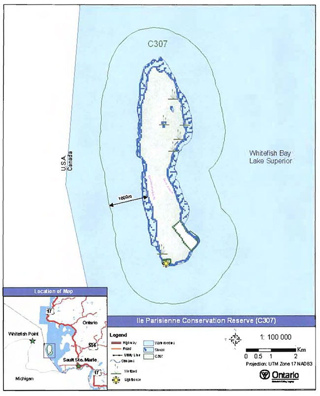
The planning area for this SCI consists solely of the regulated boundary for Ile Parisienne Conservation Reserve (see Figure 2), including a 1.6-km water zone surrounding the island. However, to fully protect values within the conservation reserve, the area beyond the regulated boundary may require additional consideration when larger land use planning initiatives pose potential negative impacts on the conservation reserve.
4.0 Background information
4.1 Location and site description
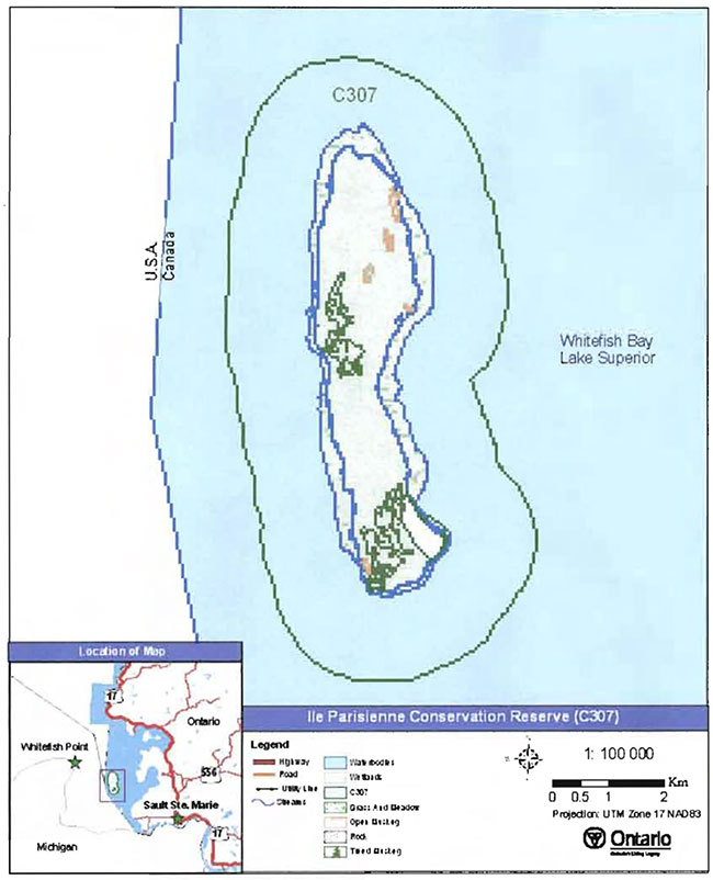
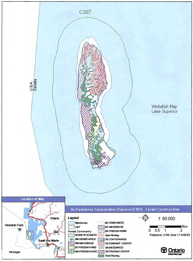
Ile Parisienne Conservation Reserve is located at the north end of Whitefish Bay in Lake Superior, approximately 25 km northwest of the City of Sault Ste. Marie. This site was regulated on April 6, 2001, and is 4,669 hectares in size. It consists of an island approximately 8 km in length north to south, and 2 km at its widest point. The island is surrounded by a 1.6-km marine boundary (extending from the water’s edge) which accounts for approximately 80 percent of the conservation reserve’s entire area (see Figure 2). Table 1 summarizes the administrative details of the site.
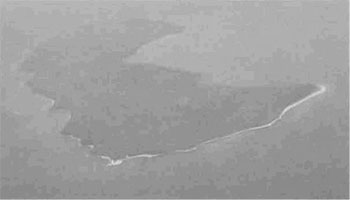
Figure 1: Aerial view of Ile Parisienne looking north.
(Photo by B. Burkhardt; September 2003)
Whenever possible, recognizable natural and cultural features, such as creeks, shorelines or old roads, have been used to delineate conservation reserve boundaries to facilitate on-the-ground identification. The boundaries of Ile Parisienne Conservation Reserve are defined by the marine buffer surrounding the island and extending 1.6 km from the shoreline into Whitefish Bay. On the island itself, two patented parcels are excluded from the conservation reserve. These include a private property located in the southeastern portion of the island, and another property on the southwestern tip of the island occupied by the Department of Transport (see Appendix A, Map 1).
Figure 2: Site Location for Ile Parisienne Conservation Reserve (C307).
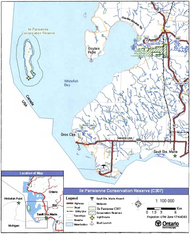
Enlarge Figure 2: Site Location for Ile Parisienne Conservation Reserve (C307).
Ile Parisienne Conservation Reserve is not an easily accessible site due to its marine location. Boat launches at Goulais Point and Gras Cap provide water access to the site, which entails crossing a large expanse of open water. Due to the unpredictable nature of Lake Superior, the ride by boat can vary from between thirty minutes to more than two hours. Ile Parisienne is located 15 km from Gras Cap and 12 km from the nearest point of land at Goulais Point, found in the northern end of Whitefish Bay. Shallow shoals, boulder lag deposits surrounding the island, and cobble spits located at the northern and southern tips inhibit larger marine vessels from traveling within close proximity to the shore. Boats are commonly observed mooring offshore or docking at the Coast Guard facilities on the southern tip of the island.
No permanent trails or roads have been identified by aerial or land reconnaissance surveys on Ile Parisienne. Beaches along the island’s perimeter make walking around the island possible, while traveling throughout the interior is more difficult due to dense forest communities and numerous wetlands. Additionally, the interior is difficult to access from some areas along the western side of the island due to the presence of Jacobsville Sandstone bluffs, up to 6 m in height.
Table 1. Location and administrative details for Ile Parisienne Conservation Reserve.
| Name | Ile Parisienne Conservation Reserve (C307) |
|---|---|
| Site Region - Site District (Hills 1959) | 4E-2 (Batchewana) |
| Eco Region - Eco District (Crins and Uhlig 2000) | 5E-13 (Georgian Bay) |
| OMNR Administrative Region/District/Area | Northeast Region/Sault Ste. Marie District/Algoma Area |
| UTM co-ordinates | Zone 16- 673750, 5173079 |
| Area | Total area: 4,669 ha, Land area: 991 ha, Water area 3,678 ha |
| Nearest City/Town | 25 km northwest of the City of Sault Ste. Marie |
| Township(s) | Not Applicable |
| OBM Numbers | 2016670051700, 2016670051600 |
| Topographical Map Number / Name | Map Sheet 41 K 10- Isle Parisienne |
| Wildlife Management Unit | 36 |
| Forest Management Unit | Algoma Forest |
| Regulated | April 6, 2001 |
| SCI Completed | February, 2005 |
Ile Parisienne Conservation Reserve is located in Hills' Site District
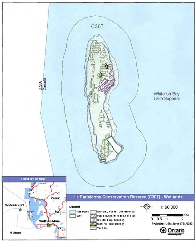
Ile Parisienne Conservation Reserve is reported by King & Longyear (2004) to have medium diversity based on the variety of forest communities and wetlands within its boundaries, and the dominance of mixed hardwood stands on glacial deposits. Dominant tree species on the island include red maple, black spruce, balsam fir and white birch. Other forest communities represented are yellow birch (Betula alleghaniensis), sugar maple (Acer saccharum), silver maple (Acer saccharinum) and white pine (Pinus strobus). Wetlands within the conservation reserve include open bog, treed bog, and various wetland complexes containing moderately rich fen, semi-treed bog, treed bog, and shore fen.
4.2 History of the site
Ile Parisienne has played a major role in maritime travel dating back to the early 1800s. Its location along the primary shipping channel of Lake Superior often brought travelers seeking the island’s protection and safety from storms. Historical documents indicate that a number of shipwrecks are known to have occurred within Whitefish Bay, including the Edmund Fitzgerald in November, 1975. Many authors reference Ile Parisienne, its surrounding shoals, and pictured rocks as a frequent site for collisions, foundering, and sinking of ships during the past two centuries.
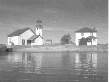
Figure 3: Coast Guard Station located at the most southerly tip of Ile Parisienne.
(Photo by T. Latulippe; August 2002)
Perhaps the first recorded sailing expeditions on Lake Superior occurred years ago by Aboriginal peoples who pursued the copper deposits of Ile Royale (the Keewenaw) at the west end of Lake Superior, and were also involved in fur trade alliances and military partnerships. They traveled in birch bark canoes which later were equipped with sails (SchoolNet Digital Collections Program, Industry Canada 1998) to accommodate more material and passengers. In August of 1816, during a Canadian interfamily feud for domination of the fur trade Industry in North America, one canoe traveling from Montreal to the United States is known to have capsized off Ile Parisienne, Whitefish Bay, with 7 to 11 lives lost. The canoe was being manned by Lord Selkirk’s soldiers of the Hudson Bay Company, carrying Northwest Company leaders as prisoners, and paddled by Iroquois Indians (Wolff 1987).
Ile Parisienne in its entirety was held by the Crown until 1902, at which time a fishing company purchased a parcel of land approximately 46.1 ha (114 acres) in size, in addition to a 4.0 ha (10 acre) water lot located at the southeastern corner of the island. Initially this lot was intended for commercial usage; however, plans for the building of structures dissolved and today the lot remains undeveloped. In 1912, a lighthouse was established at the most southwesterly tip of the island (see Figure 3); three years later, a request was made by the Department of Transport to reserve approximately 4.0 ha of the land to be patented for developments associated with the lighthouse. In years following, additional Coast Guard Station structures were built including a bunkhouse, helicopter landing pad and dock. The Coast Guard Station Is still in existence today, and continues to be active in navigational aid. The lighthouse is visible in the channel from each direction and marks the entrance to the St. Marys River (Baird 1999).
4.3 Inventories
Table 2 (on the following page) indicates the current status of natural heritage Inventories that have been conducted in association with Ile Parisienne Conservation Reserve. Recommendations for future inventory needs are located in Table 3, Section 7.2.
Table 2. Existing inventory and survey information for Ile Parisienne Conservation Reserve.
| Type of Inventory | Inventory Method | Date(s) of Inventory | Report |
|---|---|---|---|
| Life Science | Ground and aerial reconnaissance | Ground: 7 Aug.,2002, 18-21 July, 2003, Aerial: 10 Sept., 2003 | King, L. and Longyear, S. 2004. Ile Parisienne Conservation Reserve, Life Science Checksheet - Step 4. Unpublished Information. Ontario Ministry of Natural Resources. (Draft) |
| Earth Science | Ground and aerial reconnaissance | Ground: 18 July, 2003, Aerial: 10 Sept., 2003 | Kor, P. 2004. Earth Science Inventory Checklist- Ile Parisienne Conservation Reserve. Unpublished Information. Ontario Ministry of Natural Resources. |
| Recreation | Ground and aerial reconnaissance | Ground: 7 August, 2002; 18-21 July 2003; 6 October, 2004, Aerial: 10 Sept.,2003 | Hall, M. 2004. Recreation Inventory Report - Ile Parisienne Conservation Reserve (C307), Version 1. Unpublished Information. Ontario Ministry of Natural Resources. |
5.0 State of the resource
5.1 Key values
Key values are those values that make this site unique and have led to its designation as a conservation reserve. Their protection is paramount. The key values found within Ile Parisienne Conservation Reserve include the following:
- Provincially significant Jacobsville Sandstone outcrop areas
- Beaches, dunes and boulder lags
- Important spawning habitat for lake trout and whitefish within the 1.6-km marine zone
- Old stands of white and birch and balsam fir
- Nesting, breeding and feeding habitat for waterfowl, shorebirds, migratory birds and raptors
- Super-canopy white pine and black spruce located along the ridge of the island
- Historical importance in marine culture and travel
Additional values as listed in Section 5.2 through Section 5.6 are also important. Descriptions in this section are not necessarily complete. If new values, key or otherwise, are identified, they will be added to this section. If any new value is considered significant, management guidelines may be modified, if required, to ensure its protection.
5.2 Earth sciences values
Ile Parisienne Conservation Reserve lies at the southern end of a submerged bedrock ridge which joins Corbeil Point in Ontario to Point Iroquois in Michigan. This ridge, approximately 30 km long, is defined and surrounded by linear troughs over 40 m deep, which are present due to glacial and post glacial erosion activity when the southern portion of Lake Superior was occupied by glacial ice. The ridge on whichlie Parisienne is located may have become ice-free for the last time over 11,000 ybP (years before Present), at which time all or part of the Superior basin was occupied by glacial Lake Algonquin. After a long history of submergence and emergence in glacial and postglacial lakes in the eastern Superior basin, the island emerged for the last time only relatively recently, about 3,000 to 2,000 years ago (Farrand and Drexler 1985).
The historical hydrological activities endured by Ile Parisienne and the effects of postglacial waters surrounding its shores account for the thick coverage of glacial sands and unconsolidated sediments which have been deposited and modified by the continuing action of currents and waves. Ile Parisienne is ringed almost entirely by a narrow beach zone. Fine-grained sandy beaches interspersed between outcrops of sandstone along the western shore, and large concentrations of coarser grained deposits found on the eastern shore, indicate weathering and erosion occurred predominately on the west side of the island. Glacial ice-deposited material in the form of randomly placed boulders in the off-shore zone of the island, and cobble spits and bars, (see Figure 5) generally parallel to the present day shoreline, lie abandoned and vegetated along the length of the eastern portion of the island. Many of these beach ridges, with their thick forest growth, stand out clearly from the low, intervening swales which are dominated by scrub and wetland vegetation (Kor 2004).
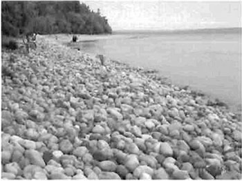
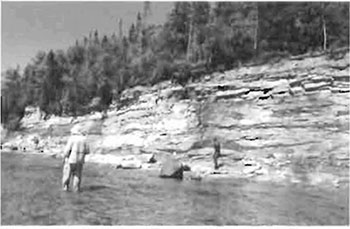
The bedrock of Ile Parisienne formed during the Late Pre-Cambrian era consists predominately of white to red, coarse-grained sandstone in thin-bedded strata belonging to the Jacobsville Group. Commonly called Jacobsville Sandstone, red streaking occurs throughout the outcrops often in parallel, wavelike and circular patterns. Sandstone bedrock shoals surrounding the island are visible from aerial surveys, and vertical bluff outcrops (up to 6 m high) of Jacobsville Sandstone occur on the west side of the island (see Figure 7). Raised sandstone cobble and boulder beaches are located along the western and northeasterly shores, and along the southeastern shore, north of the beach sand dunes (see Figure 4). In Ontario, exposures of Jacobsville Sandstone are restricted to occasional outcrops along the eastern shore of Lake Superior from Sault Ste. Marie to Grindstone Point in Lake Superior Provincial Park (Ayres 1969), and on several islands in the eastern part of the Superior basin including this conservation reserve. According to Kor (2004), the rarity of outcrops within Ontario, the excellent exposure on this island, and its undisturbed nature, result in Jacobsville Sandstone on Ile Parisienne being ranked provincially significant. The surficial features including the raised and modern beaches, dunes, and boulder lags are shared characteristics with those on the nearby North and South Sandy islands and Caribou Island.
Figure 4: Raised sandstone cobble beach merging into a raised modern sandy beach, westcentral shore of Ile Parisienne.
(Photo by D. Hall; July 2003)

Figure 5: Cobble spit and glacial deposited boulders, located along eastern shore of the island.
(Photo by D. Hall; July 2003)
Additionally, several beach localities on Ile Parisienne host unique conglomerate deposits of pebbles, boulders and cobble, dark brown to black in colour, and appearing covered entirely by thick coats of lacquer (see Figure 6). Kor (2004) relates the presence of the shiny rocks as a probable result of continuous seeping of organic material from wetland complexes behind the beaches via seeps and springs, involving chemical reactions with iron. Kor refers to the deposits as boulder lag patina, and provides a proposed explanation for this phenomenon in the Earth Science Inventory Checklist (2004). It remains to be determined whether similar exposures of these unique deposits exist elsewhere.
Figure 6: Boulder lag patina, shiny rock conglomerates, located along central-east shore and southwest tip of island.
(Photo by T. Latulippe; August 2002)
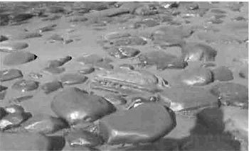
Figure 7: Jacobsville Sandstone bluffs central-western shore of Ile Parisienne
(Photo by 5.Walsh; July 2003)
5.3 Life sciences values
Ile Parisienne Conservation Reserve supports a medium diversity of forest communities and various wetland complexes. Forest stands within the site consist predominately of mixed hardwoods
Stocking
Wetlands and wetland complexes account for a large portion of the conservation reserve’s land area, particularly treed muskegs (bog complexes) located in the west-central and southern portions of the island which account for nearly 60% of the total land area (King and Longyear 2004; see Figure 8; Appendix A, Map 4). Additional wetland communities within the site include open bog and treed bog, and complexes consisting of moderately rich fen, semi-treed bog, open bog, treed bog and shore fen. Common tree, shrub, and herb species identified within the wetland areas of the conservation reserve during ground reconnaissance include Canada yew (Taxus canadensis), tamarack (Larix laricina), pitcher-plant (Sarracenia purpurea), round-leaved sundew (Drosera rotundifolia) and swamp pink orchid (Calopogon tuberosus; see Figure 10).
Figure 8: Aerial view of wetland complexes centrally located on Ile Parisienne.
(Photo by S.Walsh; September 2003)
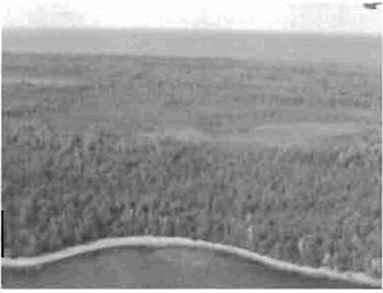
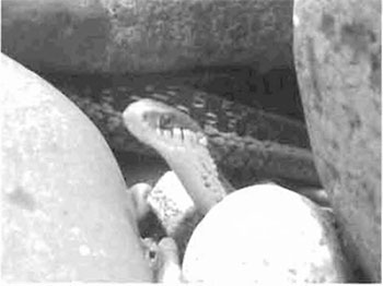
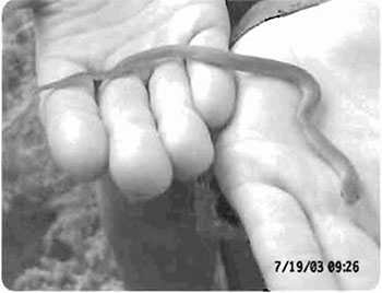
Figure 9: Common garter snake (Thamnophis sirtalis) amongst boulders and cobbles of Ile Parisienne’s beach.
(Photo by M. Hall; July 2003)
The marine boundary surrounding Ile Parisienne accounts for nearly 80% of the entire conservation reserve and provides spawning habitat for lake trout and whitefish along the eastern coast of the island. According to a Ministry of Natural Resources' Conservation Officer, shoals within and outside of the conservation reserve additionally provide habitat for lake herring (Coregonus arteddi), rainbow trout (Oncorhynchus mykiss) and Atlantic salmon (Salmo salar; Oswald pers.comm.).
Ile Parisienne is located within Zone 34 of Lake Superior’s Jake trout management areas. This zone is co-managed by Ontario Ministry of Natural Resources and its United States counterparts (Greenwood pers.comm.). According to the Lake Superior Lake Trout Stocking Review (Powell and Atkinson 1991), management by the OMNR for lake trout will continue, however, stocking will be postponed until the exploitation of lake trout in this zone subsides. In Zone 33, just north of Ile Parisienne, approximately 50,000 yearling lake trout are stocked annually. Population index surveys are conducted periodically for whitefish, and wild and stocked lake trout around Ile Parisienne (Greenwood pers.comm.).
Ile Parisienne is located along a major bird migratory route and the shoals, shore, forest and wetland communities provide habitat for a variety of migratory species, shorebirds, waterfowl and raptors. Forty-four bird species were identified during a 2-day, mid-summer land reconnaissance on the Island, of which breeding evidence was confirmed for 8 species; including, common merganser (Mergus merganser), downy woodpecker (Picoides pubescens), red-breasted nuthatch (Sitta canadensis), cedar waxwing (Bombycilla cedrorum), sparrow (Melospiza spp), and warbler (Dendroica spp) species. A pair of bald eagles (Haliaeetus leucocephalus) and peregrine falcons (Falco peregrinus) were also observed flying above the conservation reserve (Hall et.al. 2003). Both raptor species are classified, provincially, as "Endangered" according to the Committee of the Status of Species at Risk in Ontario (2004). Peregrine falcons are also designated as "Species Threatened" according to the Committee on the Status of Endangered Wildlife in Canada (2003).
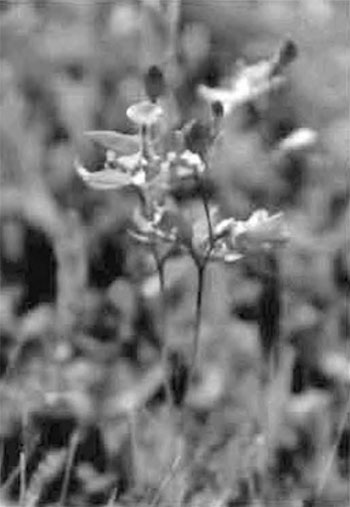
Figure 10: Swamp pink orchid (Calopogon tuberosus), found abundantly within wetlands of the conservation reserve.
(Photos by 5. Walsh; July 2003)
According to Sault Ste. Marie District staff, in 1989 approximately 15-20 white tailed deer (Odocoileus virginianus) were located to Ile Parisienne from the City of Sault Ste. Marie’s Bellevue Park (Dupont; Landry pers.comm.). An aerial survey conducted the following year concluded that the deer did not remain on the island and/or perished during the winter months. Although populations of big game were not identified on Ile Parisienne, sightings recorded in the past have included moose (Alces alces). In 2003, beaver (Castor Canadensis), red squirrel (Tamiasciurus husonicus), red fox (Vulpes vulpes) and snowshoe hare (Lepus americanus) were spotted, and amphibians Included grey tree frog (Hyla chrysoscelis), northern spring peeper (Pseudacris crucifer crucifer), eastern smooth green snake (Liochlorophis vernalis borealis) and common garter snake (Thamnophis sirtalis; see Figure 9). More detailed analysis of life science values is available in the Life Science Inventory Report for Ile Parisienne Conservation Reserve (King and Longyear 2004).
5.4 Recreational values
One of the primary attractions of this conservation reserve is the picturesque Jacobsville Sandstone outcrops. According to the lighthouse keeper, over the years, groups of 15-20 people have been noticed picnicking on the sandy beaches (see Figure 11), swimming and boating along the shore, and photographing the island’s unique bluffs, shoals, boulder lag deposits, sand, cobble and raised beaches, unique polished rocks and cobble spits. Ile Parisienne’s historical maritime features and lighthouse station provide attractions for tourists as well as local diving clubs. Scuba divers have been known to venture along the shores of Ile Parisienne to explore the submerged bedrock shoals and to dive where shipwrecks have been located, just beyond the western boundary of the conservation reserve.
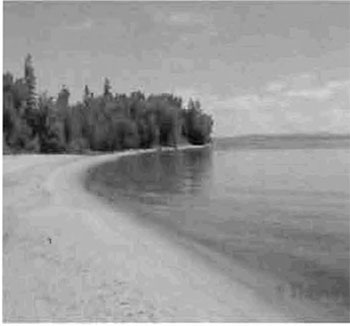
Figure 11: Sandy beach on northeast shore of Ile Parisienne.
(Photo by T. Latulippe; August 2002)
The shoals within the 1.6-km water zone of the conservation reserve provide anglers with opportunities for lake trout, whitefish, lake herring, rainbow trout and Atlantic salmon fishing. Additionally, wetlands, beaches and forest communities provide bird watching and nature appreciation opportunities for visitors exploring the interior of the island or walking the shoreline.
Commercial and recreational boating traffic is commonly observed both in and beyond the site’s boundaries. The shallow water surrounding the island limits the size and type of vessel which can land on the island’s shore. According to the lighthouse keeper, sailboats frequently moor (see Figure 13) off the east shore of Ile Parisienne and access the island by dinghy. Generally, those with canoes, kayaks, and inboard/outboard motors can access the shore. Docking for smaller vessels may be arranged with the Coast Guard Station, at the southerly tip of the island. Within the conservation reserve, there are no campgrounds, facilities or structures of any kind.
Ile Parisienne Conservation Reserve lies within the Great Lakes Heritage Coast Signature Site. More detailed analysis of existing and potential recreational uses is available in the Recreation Inventory Report for Ile Parisienne Conservation Reserve (Hall 2004).
5.5 Cultural values
This site falls within the Robinson-Huron Treaty area. To date, no First Nation community has identified any specific Aboriginal values within this conservation reserve.
Figure 12: Coast Guard lighthouse built in 1912, southern tip of island.
(Photo by J. Cywink; October 2004)

Ile Parisienne’s location along the primary shipping channel of Whitefish Bay on Lake Superior has largely contributed to its marine cultural values as well as marine archaeological history. The frequent rough waters, shoals and dense fog surrounding the island resulted in the loss of many lives due to collisions, foundering, and capsizing of ships (Wolff 1987). Ironically, the island served as a safe haven for those able to reach the shore during storms. Perhaps it was the sizable amount of tragedies and losses throughout the decades that resulted in the construction of the Coast Guard Station on Ile Parisienne (see Figure 12). Built in 1912, the lighthouse is still active in navigational aid, and guides ships in and out of Whitefish Bay with its beacon (Baird 1999).
In 1891, the Frank Perew was in tow of the steamer H.K. Fairbank when it was released in fair weather. Shortly thereafter, the waters became rough and the ship capsized. The Perew had nearly reached the beaches of Ile Parislenne when the mishap occurred. A single survivor from the Perew managed to endure the night on the island by building a fire, and was later rescued by a group of fishermen (Great Lakes Shipwrecks Museum 2004).
The 233-foot, 1,806-ton wooden steam freighter V.H. Ketchum ended its days at Ile Parisienne on September 16, 1905. Fire broke out in the cabins, and the captain beached her off the island in 23 feet of water. As the crew lowered the lifeboat, the boat capsized and resulted in two fatalities. Whitefish Bay’s collision grounds were also added to in the dense fog of June 27, 1916. Off Ile Parislenne, an up bound 478-foot, 6,025-ton steel steamer, of the Pittsburgh Steamship Company, plowed Into a 248-foot, 1,634-ton wooden steamer of the Massey Steamship Company, Duluth (Wolff 1990). Less than a decade later, In 1922, the Canadian freighter Lambton smashed into a reef off Ile Parisienne. By the time the American Coast Guard was able to reach her, the crew had abandoned ship and reached safety, with the exception of two men lost trying to make shore (Wolff 1987).
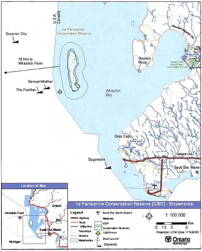
Although many of the documented wrecks reference the Island and the surrounding shoals, it is not known whether any of the archaeological shipwrecks lie within the boundaries of the conservation reserve. Coordinates for several wrecks have been located and plotted (see Appendix A, Map 5). The most proximal to Ile Parisienne Conservation Reserve is the Samuel Mather, located approximately 3 km from the southwestern boundary, and The Panther, roughly 4 km from the site. Both wrecks are located within part of the State of Michigan’s Whitefish Point Underwater Preserve, which serves to protect marine archaeological artifacts and also offers diving experiences on a variety of shipwrecks (Department of Environmental Quality- Michigan Government 2004).
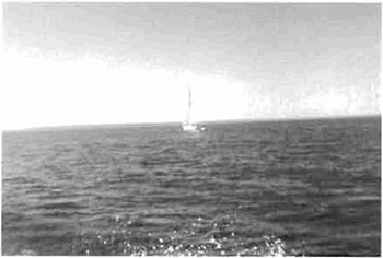
Figure 13: Sailing within the 1.6 km water boundary of the conservation reserve.
(Photo by M.Hall; July 2003)
Marine and aquatic surveys are required to confirm the presence of shipwrecks and/or associated artifacts which may be located within the marine portion of the conservation reserve.
5.6 Research values
This site falls within Region 35, within square numbers 16FS77 (northern part of island) and 16FS76 (southern) of the Ontario Breeding Bird Atlas (OBBA; www.birdsontario.org). The atlas is a repository of survey data for breeding birds across the province. Volunteers survey 10 km2 areas to assess bird species and breeding populations. To date, entries for 16FS77 have confirmed the presence of 8 species. Surveying for the OBBA will be completed in 2005. Additionally, naturalists have expressed interest in conducting in-depth migratory bird surveys on the island due to its presence along a major migration route. To date, no formal surveys have been conducted.
The Upper Great Lakes Management Unit periodically conducts population index surveys for lake trout and whitefish along the western and southern shores.
Tide and water levels are monitored by Fisheries and Oceans Canada at several benchmark locations on the Coast Guard reserve land located at the most southerly tip of the island.
5.7 Site condition
Ile Parisienne Conservation Reserve is described as having a low amount of disturbance according to King and Longyear (2004). Access to this site is difficult due to the uncertainty of weather conditions associated with Lake Superior, and the surficial features and shoals surrounding Ile Parisienne, which inhibit larger marine vessels from entering the territory.
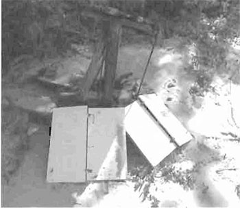
The absence of hiking trails, roads, cottages and campsites within this reserve account for its low degree of human disturbance. Most of the disturbance occurs in the form of floating debris that has gathered along the shore of the island (see Figure 14). The debris primarily consists of items of marine vessel origin (i.e. gill nets, fish bins, buoys, flags, bread racks, paint cans, plastic pails, hard hats, glass, etc.; Crofts 2003).
Along the east coast of the island, two recently used fire pits were observed during land reconnaissance on the sandy beach areas. Additionally, evidence of fire scarring on stumps was evident in different locations on the island (see Figure 15). Ministry of Natural Resources' data illustrates a small recreational fire along the central-east shore, in 1963. The abundance and size of undisturbed Canada yew and the lack of fire origin species such as jack pine (Pinus banksiana) found throughout the island, suggests that there has never been a wildfire on Ile Parisienne.
Figure 14: Debris (cupboard doors and large wooden spool) accumulated along western beach of Ile Parisienne.
(Photo by J. Cywink; October 2004)
According to Crofts (in prep. 2003), Ile Parisienne was likely exposed to a spruce budworm outbreak which occurred in the late 1970s. The northeast coastal portion of the island has a forest community of 100% stocked white birch, balsam fir, black spruce and mountain-ash (Sorbus spp) regenerating stands. The growth rings of a balsam fir regeneration sample demonstrate a significant growth period about 20 years ago. Balsam fir boles grounded in this area appear to have been canopy trees affected by the budworm. The removal of the canopy resulted in the increased rate of growth by the understory species.
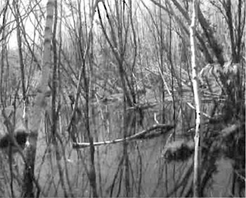
Flooding of a forest community, composed primarily of red maple and white birch (see Figure 16) along the eastern part of the island, has occurred due to beaver activity. Evidence gathered in 2003 of a lodge and travel route along the shore, supports the presence of a beaver population on Ile Parisienne, and probable cause of flooding to this area.
Figure 15: Fire scarring evidence, occurring in several locations along the island’s western perimeter.
(Photo by M.Hall; July 2003)
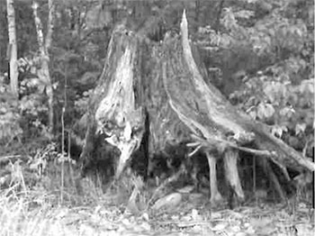
Figure 16: Beaver flooded area north of southeastern private parcel, east of semi-treed/treed bog.
(Photo by B.Burkhardt; September 2003)
6.0 Management guidelines
All management guidelines in this SCI are based on direction contained in the LUS (OMNR 1999) and associated policy clarification statements (OMNR 2000). The management guidelines outlined in this section are specific to Ile Parisienne Conservation Reserve and are intended to protect the site’s unique values. The guidelines in this document may be subject to change and may be amended as necessary. If a conflict between management guidelines exists, the conservation reserve will be managed to protect the integrity of its natural values, while permitting compatible land use activities (OMNR 1997a).
Proposed new uses and/or development, as well as research and education activities will be reviewed on a case-by-case basis. Before new proposals can be permitted, the Test of Compatibility (see Appendix C) must be passed as well as consideration of cultural values according to Conserving a Future for our Past: Archaeology, Land Use Planning & Development in Ontario, Section 3 (Ministry of Culture 1998). In addition, all new proposals are subject to applicable Environmental Assessment Act (R.S.O. 1990, Chapter E.18) requirements.
The following management strategies have been devised to achieve the goal and objectives of the SCI for Ile Parisienne Conservation Reserve. A summary table of the management guidelines for this site can be found in Appendix D. For the most up-to-date version of this summary table, please refer to the Crown Land Use Policy Atlas, located on the Internet at /page/crown-land-use-policy-atlas, or contact your local Ministry of Natural Resources office. The Crown Land Use Policy Atlas is a consolidation of existing local land use policies for Crown lands within the OLL planning area, an area that covers 45% of the province, extending from Lake Simcoe in the south to the Albany River in the north.
6.1 Industrial activities
6.1.1 Commercial timber harvest
The total area contained within this conservation reserve (4,669 ha) has been withdrawn from the Algoma Sustainable Forest License area and no commercial timber harvesting will be permitted. Please refer to Section 6.4.3 for Information regarding non-commercial wood harvesting.
6.1.2 Mining and exploration
There are no existing mining claims or leases within this conservation reserve. Mining and surface rights have been withdrawn from staking under the Mining Act (RSO 1990 Chapter M.14). Mineral exploration is not permitted.
6.1.3 Extraction of peat, soil, aggregate and other material
Extraction of peat, soil, aggregate and other material is not permitted.
6.1.4 Energy generation
New hydropower developments are not permitted within Ile Parisienne Conservation Reserve. Wind power developments are prohibited under the Public Lands Act, Procedure PL 4.10.04 "Wind Power Development on Crown Land" (OMNR 2004a).
6.2 Existing and proposed development
6.2.1 Transportation corridors
6.2.1.1 Roads
According to the LUS (OMNR 1999), new roads for resource extraction will not be permitted except for those identified in Forest Management Plans prior to March 31, 1999. No new or existing roads for resource extraction were identified. Development of new roads will not be permitted.
6.2.1.2 Trails
Aerial and ground reconnaissance surveys indicate that no trails currently exist within the conservation reserve. Any proposed new trails will be subject to the Test of Compatibility (see Appendix C) and applicable Ministry of Natural Resources' policies and procedures. Trail development in low-lying areas, wetlands and within areas where protected Jacobsville Sandstone occurs will be discouraged, as will trail development over shallow soils on rock outcrops. All new trail heads and trail routes must be recorded using new technologies (i.e. global positioning systems) to ensure an accurate record of the location of the feature. This location information must be provided to the Sault Ste. Marie District, Ministry of Natural Resources.
6.2.2 Other corridor development/maintenance
No communication, energy transmission, or other non-road corridors are located within this conservation reserve. New corridor developments will be actively discouraged. Proposals for new corridors will be subject to the Test of Compatibility (see Appendix C) and applicable Ministry of Natural Resources' policies and procedures.
6.2.3 Natural heritage appreciation facilities/recreational structures
There are currently no existing authorized natural heritage appreciation facilities or recreational structures (i.e. boardwalks, bird viewing platforms, kiosks, ski shelters, or interpretative signs). New natural heritage appreciation facilities and recreation structures are permitted, subject to the Test of Compatibility (see Appendix C) and applicable Ministry of Natural Resources' policies and procedures.
6.2.4 Land disposition
Sale of Crown lands is not permitted, except for those situations described in the policy clarification tables (OMNR 2000).
Presently, no land use permits (LUPs) have been issued within this conservation reserve for private or commercial recreational facilities. New leases or LUPs may be issued for approved public uses (i.e. not for private recreation camps), subject to the Test of Compatibility (see Appendix C) and applicable Ministry of Natural Resources' policies and procedures. These leases/permits will not be sold but may be eligible for enhanced tenure or transfer.
Enhanced tenure is defined as anything beyond the term and form of current tenure. All requests for transfer or enhanced tenure will be subject to the following screening criteria:
- Is the transfer or enhanced tenure consistent with the conservation reserve’s land use intent, which is the protection and enhancement of the site’s natural, recreational and cultural values?
- Is it consistent with the land disposition policies outlined in the District Land Use Guidelines, the Crown Land Use Policy Atlas, this SCI and any other applicable document?
- Does it adversely affect the values as identified in Section 5.0, and/or conflict with other uses?
- Is land needed by the Crown to protect significant natural or recreational values outlined in this SCI?
- Does the transfer or enhanced tenure clash with traditional Aboriginal uses, land claims or agreements?
- Are all rents, taxes, fees, rates or charges paid up for the existing LUP or lease?
6.3 Commercial activities
6.3.1 Commercial bait harvesting
Ile Parisienne is not currently allocated to any commercial bait harvesting operations. New operations can be considered subject to the Test of Compatibility (see Appendix C) and applicable Ministry of Natural Resources' policies and procedures.
Under Public Lands Act PL 3.03.08 "Buildings for Bait Harvesting Management" (OMNR 2002), cabins for the purposes of bait harvesting may be constructed on Crown land. However, such buildings should be avoided within this conservation reserve.
6.3.2 Commercial fishing
Commercial fishing activities are currently occurring within the marine portion of this conservation reserve. New operations may be considered subject to the Test of Compatibility (see Appendix C) and applicable Ministry of Natural Resources' policies and procedures. Associated building structures should be avoided within this conservation reserve.
6.3.3 Commercial fur trapping
Ile Parisienne is encompassed by SS-PL-01, which is a designation for the area dominated by private land, which includes the City of Sault Ste. Marie. This area has never been allocated to a head trapper. The remote location of this conservation reserve, and completion of the Test of Compatibility, demonstrates that potential commercial operations will have negative impacts on existing fur bearing populations, and therefore, will not be permitted. Correspondingly, the establishment of trap cabins will not be permitted.
6.3.4 Bear Management Areas
Due to the location of this site and its distance from the main land, Ile Parisienne has never been included within a bear management area (BMA). No new operations will be permitted.
6.3.5 Commercial food collection
Commercial food harvesting has never occurred on Ile Parisienne. A completed Test of Compatibility demonstrates that the remote location of this conservation reserve combined with such harvesting operations would not be consistent with the intent of the site, having negative impacts on key values, and will not be permitted.
6.3.6 Commercial non-timber forest products
Commercial harvesting of non-timber forest products is not consistent with the intent of the conservation reserve and will not be approved.
6.3.7 Outpost camps/main base lodges
There are currently no existing authorized outpost camps or main base lodges in the conservation reserve. A completed Test of Compatibility illustrates that the size of this conservation reserve and the values being protected within the site (i.e. sandstone, wetlands, vegetated sand dunes, forest communities, etc.), may be jeopardized by the construction of any establishment; therefore, new outpost camps and main base lodges will not be permitted.
6.4 Non-commercial activities
6.4.1 Nature appreciation/recreation activities
The marine location and absence of identified trails within this site limits the occurrence of recreational and nature appreciation activities. Off-trail hiking, cross-country skiing, snowshoeing, and other non-motorized activities will be permitted within this conservation reserve. However, should the impact of these activities degrade the landscape, the Ministry of Natural Resources will re-evaluate these permitted uses and decide upon a new strategy for this site. New trails to support these activities may be considered. Please refer to Section 6.2.1.2 for more details related to trail development.
6.4.2 Camping
There are no maintained campsites or campgrounds within this conservation reserve, although several locations along its sandy beaches have been used as tenting sites. Crown land camping policies apply, unless adverse effects on protected values necessitate further planning and management for this activity. Campers should avoid sensitive areas on the island (i.e. Jacobsville Sandstone outcrops, vegetated dunes and shallow soil areas).
6.4.3 Non-commercial consumptive resource use
Cutting of trees for non-commercial purposes may be authorized via a permit issued by the local Ministry of Natural Resources office, subject to review and determination of the impact that such cutting would have on the values identified in Section 5.0. Generally, such permits are intended only for leaseholders, land use permit (LUP) holders, cottagers and other property owners within the conservation reserve who do not have road access to their property and have no alternate wood source outside of the conservation reserve. This permit is intended to cover fuel wood, dock stringers, and other occasional small scale uses.
However, Ile Parisienne Conservation Reserve has no lease or LUP holders, cottagers or other property owners within its boundary. Additionally, due to the remote island location, and the sensitivity of wetland areas and Jacobsville Sandstone outcrops within this conservation reserve, cutting of trees will be discouraged, and individuals will be encouraged to transport their own and/or gather and utilize existing fallen trees.
Non-commercial harvesting of non-timber forest products such as berries and mushrooms can occur provided the values of the site, identified in Section 5.0- State of the Resource, are not jeopardized.
6.4.4 Hunting and fishing
Hunting and fishing are permitted to continue within this conservation reserve, in conjunction with current hunting and/or fishing regulations and conservation reserve policy.
6.4.5 ATV and snowmobile use
No trails have been identified within the conservation reserve. Please refer to Section 6.2.1.2 for more information on trails. A Test of Compatibility demonstrated the potential for ATV and snowmobile traffic to have negative impacts on the site’s sandstone outcroppings, vegetated sand dunes and wetlands. Because these vehicles are capable of traveling on both land and ice, when the marine portion of the conservation reserve is frozen, ATVs and snowmobiles will be permitted on the ice. However, neither ATVs nor snowmobiles are permitted on the island or in its shallow waters at any time. Should ATV or snowmobile activities create negative impacts on the values of the conservation reserve, the Ministry of Natural Resources will re-evaluate the permitted use and develop a new strategy.
6.4.6 Watercraft use
This conservation reserve includes a large marine zone, which constitutes approximately 80% of the site’s total area, and protects provincially significant Jacobsville Sandstone shoals, spawning habitat for lake trout and whitefish, as well as providing habitat for waterfowl and other shorebirds. Existing shallow waters, boulder lags and spits surrounding Ile Parisienne inhibit larger marine vessels from traveling closely to the shoreline. Smaller watercraft usage within the conservation reserve is permitted to continue; however, individuals are encouraged to use safe boating practices and to avoid disturbance of sensitive features. Should the impact of watercraft degrade the marine portion of the conservation reserve, the Ministry of Natural Resources will re-evaluate these permitted uses and determine a new strategy.
6.4.7 Removal/ disturbance of cultural and archaeological artifacts
To date, no cultural or archaeological artifacts have been identified within this conservation reserve. Under the Ontario Heritage Act (R.S.O. 1990, Chapter 0.18, Section 47), recovery of artifacts and/or disturbance of an archaeological site, including a marine archaeological site, requires a licence issued by the Ministry of Culture. The activities proposed by licenced applicants must be consistent with the conservation, protection and preservation of Ontario’s heritage.
6.5 Resource management activities
Resource management activities refer to those tools used to protect and enhance the values of this conservation reserve. Some management activities may require the use of intrusive techniques. Under normal circumstances, some of these techniques would not be permitted to occur in the conservation reserve; however, if they are found to be necessary, they may be applied under controlled conditions, to achieve a desired result. Infrastructure such as trails and buildings may need to be constructed to support activities such as prescribed burns, forest regeneration, wildfire control, and insect and disease control. Activities described in this section will be deemed acceptable if the ultimate outcome is in compliance with the management intent for this conservation reserve.
6.5.1 Insect and disease control
This conservation reserve will be maintained in as natural a state as possible. Insect and disease control measures should only be considered if the identified values are significantly threatened.
6.5.2 Fire management
The Ministry of Natural Resources recognizes fire as an essential process fundamental to the ecological integrity of conservation reserves. In accordance with existing conservation reserve policy and the Forest Fire Management Strategy for Ontario (OMNR 2004b), forest fire protection and normal fire suppression activities will be carried out on Ile Parisienne similarly to surrounding main lands, with the exception of access being limited to boat or air travel.
Whenever feasible, the Ministry of Natural Resources' fire program will endeavor to use "light on the land" techniques, which do not unduly disturb the landscape, in this conservation reserve. Examples of light on the land techniques may include limiting the number of trees felled during the fire response efforts.
Opportunities for prescribed burning to achieve ecological or resource management objectives may be considered. These management objectives will be developed with public consultation prior to any prescribed burning, and will be reflected in the document that provides fire management direction for this conservation reserve. Plans for any prescribed burning will be developed in accordance with the Ontario Ministry of Natural Resources' Prescribed Burn Planning Manual (OMNR 1997b) and the Environmental Assessment Act (R.S.O. 1990, Chapter E.18).
6.5.3 Fish and wildlife management
New fish and/or wildlife management activities may be considered but will require the approval of either a separate fish/wildlife management plan, which must be referenced in this SCI, and/or an amendment to this SCI to include specific management prescriptions. New fish and wildlife management activities are also subject to the Test of Compatibility (see Appendix C) and applicable Ministry of Natural Resources' policies and procedures.
6.5.4 Vegetation management
New vegetation management activities may be considered but will require the approval either a separate vegetation management plan, which must be referenced in this SCI, and/or an amendment to this SCI to include specific management prescriptions. New vegetation management activities are also subject to the Test of Compatibility (see Appendix C) and applicable Ministry of Natural Resources' policies and procedures.
6.5.5 Forest renewal
Preference will be given to natural regeneration following any disturbance in the conservation reserve. In some cases, regeneration may be artificially assisted when it is deemed appropriate to mitigate against human disturbances (i.e. illegal occupation and trespass).
6.6 Research
Scientific research is encouraged, by qualified individuals or institutions, that contributes to a better understanding of the natural and cultural values protected by this conservation reserve, or that advances the protection, planning and management of these values. The Sault Ste. Marie District Planner should be contacted for information on research and/or monitoring opportunities within this conservation reserve. Proposals to conduct research should be directed to the Algoma Area Supervisor, Ministry of Natural Resources, Sault Ste. Marie District Office, and will be subject to the Test of Compatibility (see Appendix C) and applicable Ministry of Natural Resources' policies and procedures. Any site that is disturbed during research activities is to be rehabilitated as closely as possible to its original condition. Collecting may only be permitted as part of an authorized research project and may be subject to appropriate permits and conditions.
Existing Forest Resource Inventory surveys and approved resource monitoring activities are permitted to continue.
6.7 Marketing
No active marketing of this conservation reserve by Sault Ste. Marie District, Ministry of Natural Resources is anticipated. However, Ile Parisienne has been included in promotional materials for the Great Lakes Heritage Coast Signature Site (www.greatlakesheritagecoast.com (link no longer active)) and on the Wildlands League website (www.wildlandsleague.org).
6.8 First nations
Traditional activities and Aboriginal rights, as defined in the Robinson-Huron Treaty and other applicable legislation, will not be affected within or by the boundaries of this conservation reserve.
Any First Nation land claims within this area will be addressed according to appropriate Ministry of Natural Resources' procedures. When possible, the Ministry of Natural Resources will work with any First Nation community within the Robinson-Huron Treaty area and/or Ontario Ministry of Culture to identify archaeological sites to be protected.
7.0 Recommendations
7.1 Additions to the reserve
Ile Parisienne Conservation Reserve encompasses an entire island surrounded by a marine boundary of 1.6 km extending from the water’s edge, with the exception of two parcels of privately owned land not included in the conservation reserve. The private land parcels are located at the southern end of the island; one remains undeveloped and includes a 4.0 ha water lot, and Coast Guard developments have occurred on the other. To capture and protect the entirety of Ile Parisienne, its core values, and resources, consideration should be given to the purchase of the undeveloped, 46.1 ha of land and additional 4.0 ha water lot located at the southern portion of the island. Any opportunity to incorporate the Coast Guard lighthouse property into the conservation reserve should be considered. This acquisition would serve to protect the cultural and historical interest of the island.
7.2 Future needs and considerations
It is recommended that the values protected by this site be considered in land use management activities on adjacent properties to ensure sufficient protection of the site’s core values. Furthermore, the large marine component of this conservation reserve requires more detailed investigation in order to better protect its features.
Table 3 (on the following page) highlights future needs and considerations for Ile Parisienne Conservation Reserve.
7.3 Monitoring
Periodic monitoring of human activities and/or their impacts within this conservation reserve will be conducted. A schedule for cursory field monitoring will be identified within the District’s annual compliance plan and an IFM (Integrated Field Monitoring) inspection report will be filed at the Sault Ste. Marie District Office. The Algoma Area Supervisor will oversee these activities. In addition, Conservation Officers will complete periodic compliance monitoring to ensure the protection mandate is maintained. If at any time human activities are deemed to be negatively impacting the protected features, the activities will be reviewed and measures taken to mitigate any disturbance. Approved inventory, monitoring, assessment, or research activities that are compatible with protection objectives are encouraged. Any area that is disturbed during research activities is to be rehabilitated as closely as possible to its original condition. The Algoma Area Supervisor may apply additional conditions.
Table 3: Future needs and considerations for Ile Parisienne Conservation Reserve
| Future Needs/Considerations | Details |
|---|---|
| Complete Life Science Inventory | The Northeast Region should complete the final stage of the life science inventory. Completion of the final stage of life science inventory includes an assessment of the site’s significance and its contribution to the parks and protected areas program. |
| Marine Archaeological Inventory | Research should be conducted to confirm the presence/absence of marine archaeological artifacts within the site’s water zone for the protection and preservation of marine heritage sites. |
| Detailed Earth Science Inventory | MNR's Senior Conservation Geologist recommends that the surficial geology be studied in more detail; additionally a more thorough examination of the Jacobsville Sandstone (i.e. susceptibility to weathering and erosion) should be considered. |
| Adjacent Property Owner Involvement | Efforts should be made to work with landowners of adjacent private lands. Specific consideration should be given to protecting Jacobsville Sandstone outcroppings, forest and wetland communities. |
| Signage | Installation of appropriate signage (i.e. removal of Jacobsville Sandstone is not permitted; use of ATVs and snowmobiles on land/in shallow water is prohibited etc.). |
| Partnership Development | Efforts should be made to work with partners (such as Aboriginal communities, the Ministry of Transport Coast Guard, Ontario Forest Research Institute (OFRI), Sault College of Applied Arts and Technology) to gather baseline data on this site to assist with future monitoring and inspection activities. |
| Winter Recreation Assessment | Efforts should be made during winter months to further assess the intensity of ice-fishing, snowmobiling and other winter recreation activities occurring within the conservation reserve. |
| Education | Educate public who use Crown land features in/around this conservation reserve about the site’s natural heritage; protection intent of the CR; permitted uses; etc. |
| Funding | Efforts should be made to obtain funding to support the above listed items, including monitoring, assessment, and inspection requirements for this site. |
8.0 Implementation, review and revisions
8.1 Responsibility
The Sault Ste. Marie District will be responsible for implementing the management policies and guidelines for Ile Parisienne Conservation Reserve. The primary role will be to provide public information and compliance monitoring to ensure adherence to current policies and guidelines.
8.2 Review and revisions
The Ile Parisienne Conservation Reserve SCI will be reviewed every five years by the District Planner to confirm and update the information in this document. Revisions to this document will be subject to requirements as specified in the Environmental Assessment Act (R.S.O. 1990, Chapter E.18). If changes in management direction are needed at any time, the significance of the changes will be evaluated. Minor amendments to the plan that do not alter the overall protection objectives may be considered and approved by the Area Supervisor without further public consultation. All minor amendments to the SCI will be documented in Appendix F. In assessing major amendments, the need for a more detailed Resource Management Plan (RMP) will first be considered. Where a RMP is not considered necessary or feasible, a major amendment to management direction may be considered with public consultation. Major amendments will be recommended by the District Manager and approved by the Regional Director, and will follow the appropriate guidelines (OMNR 2001b).
Acknowledgements
Special acknowledgement is given to Conservation Officer, Bruce Thomlinson, and Deputy Conservation Officer, Stephanie Lapointe, from the Upper Great Lakes Management Unit, who provided transportation to and from Ile Parisienne, so that extensive inventory work could be completed for this conservation reserve.
Special thanks to Lighthouse Caretaker, Fred Ruston who welcomed us to the island, shared his stories and experiences, and provided transportation around the island.
Additional thanks are extended to the following individuals who volunteered their time and knowledge to assist with inventory work:
- Chuck Bosley
- Mark Crofts
- Don Hall
- Vivian Hall
- John Johnson
- Evelyn Simons
- Don Wilshere
Without assistance from the above listed individuals, an assessment with this level of detail would not have been possible.
Literature cited
Ayres, L.D. 1969. Geology of Townships 31 and 30, Ranges 20 and 19; Ontario Department of Mines, Geological Report 69.
Baird, D. 1999. Northern Lights-Lighthouses of Canada. Lynx Images Inc., Toronto, Ontario.
Committee of the Status of Species at Risk in Ontario (2004). [Accessed: November 22, 2004] http://www.speciesatrisk.gc.ca (link no longer active)
Committee on the Status of Endangered Wildlife in Canada (2003). [Accessed: November 22, 2004] www.cosewic.gc.ca.
Crins, W.J. 1996. Life Science Gap Analysis for Site District 4E-3. Unpublished information. Ontario Ministry of Natural Resources.
Crins, W.J. and P.W.C. Uhlig, 2000. Ecoregions of Ontario: Modification to Angus Hills' Site Regions and Site Districts - Revisions and Rationale.
Crofts, M. 2003. Isle Parisienne Conservation Reserve, Notes from Field Visit. Unpublished information. Ontario Ministry of Natural Resources.
Department of Environmental Quality- Michigan Government. 2004. [Accessed: July 28, 2004] http://www.michigan.gov/deq/0,1607,7-135-3313_3677_3701-14591--,00.html.
Dupont, A. Algoma Area Biologist, Ontario Ministry of Natural Resources. Personal Communication. July, 2004.
Farrand, W.R. and Drexler, C.W. 1985. Late Wisconsinan and Holocene History of the Lake Superior Basis; in Quaternary Evolution of the Great Lakes. Geologic Association of Canada, Special Paper 30.
Great Lakes Shipwreck Museum- Shipwreck Stories, The Frank Perew. 2004. [Accessed: July 7, 2004] http://www.shipwreckmuseum.com/stories.phtml (link no longer active).
Greenwood, S. Management Biologist, Ontario Ministry of Natural Resources. Personal Communication. November, 2004.
Hall, M. 2004. Recreation Inventory Report- Ile Parisienne Conservation Reserve (C307). Unpublished information. Ontario Ministry of Natural Resources.
Hills, G.A. 1959. A Ready Reference for the Description of the Land of Ontario and its Productivity. Preliminary Report. Ontario Department of Lands and Forests. Maple. Ontario.
King, L. and Longyear, S. 2004. Ile Parisienne Conservation Reserve (C307), Life Science Checksheet - Step 4. Unpublished information. Ontario Ministry of Natural Resources.
Kohl, C. 1998. The 100 Best Great Lakes Shipwrecks Volume II, Lake Michigan Lake Superior. Seawolf Communications Inc., Chicago, Illinois.
Kor, PSG. 2004. Earth Science Inventory Checklist for Ile Parisienne Conservation Reserve (C307). Unpublished information. Ontario Ministry of Natural Resources.
Landry, J. Fish & Wildlife Technical Specialist, Ontario Ministry of Natural Resources. Personal Communication. July, 2004.
Marshall, J. 1987. Shipwrecks of Lake Superior. Lake Superior Port Cities Inc., Duluth, Minnesota.
Ministry of Culture. 1998. Conserving a Future for Our Past: Archeology Land Use Planning and Development in Ontario. Ministry of Culture, Heritage and Libraries Branch - Heritage Operations Unit.
Nicholson, J., Burkhardt, B., King, L. and Longyear, S. 2003. Basswood Lake Conservation Reserve Life Science Checksheet- Step 2. Unpublished Information. Ontario Ministry of Natural Resources.
Noble, T. 1983. Life Science Report, Site Region 4E-Northeast Region. Ontario Ministry of Natural Resources.
Ontario Ministry of Natural Resources, 1997a. Conservation Reserves. Lands and Waters Branch Policy. Public Lands Act, PL 3.03.05. Date Issued: February 11, 1997.
Ontario Ministry of Natural Resources, 1997b. Prescribed Burn Planning Manual. AFFMB Publication No. 313. Ontario Ministry of Natural Resources.
Ontario Ministry of Natural Resources. 1999. Ontario’s Living Legacy Land Use Strategy. Queen’s Printer for Ontario: Ontario, Canada.
Ontario Ministry Natural Resources. 2000. Policy Clarification for Conservation Reserves. Unpublished document. September 2000.
Ontario Ministry of Natural Resources. 2001a. Forest Information Manual. Queen’s Printer for Ontario: Toronto, Ontario.
Ontario Ministry Natural Resources, 2001b. Procedures for the Amendment of Ministry of Natural Resources Land Use Direction. Ontario Ministry of Natural Resources.
Ontario Ministry of Natural Resources, 2002. Buildings for Bait Harvesting Management. Public Lands Act, PL 3.03.08.
Ontario Ministry of Natural Resources. 2003. Vulnerable, Threatened, Endangered, Extirpated or Extinct Species of Ontario. [Accessed: July 13, 2004] http://www.ontarioparks.com/saro-list.pdf
Ontario Ministry of Natural Resources. 2004a. Wind Power Development on Crown Land. Lands and Waters Policy Branch. Public Lands Act, PL 4.10.04. Date Issued: January 27, 2004.
Ontario Ministry of Natural Resources. 2004b. Forest Fire Management Strategy for Ontario. Queen’s Printer for Ontario: Ontario, Canada.
Oswald, K. Conservation Officer, Ontario Ministry of Natural Resources. Personal Communication. July, 2004.
Powell, M.J and Atkinson, J. 1991. Lake Superior Lake Trout Stocking Review. Ontario Ministry of Natural Resources.
R.S.O. 1990, Chapter 0.18, Section 47. Ontario Heritage Act. [Accessed: July 29, 2004] http:/ /192.75.156.68/DBLaws/Statutes/English/90o18_e.htm (link no longer active).
R.S.O. 1990, Chapter E.18. Environmental Assessment Act. [Accessed: September 15, 2003] http://www.e-laws.gov.on.ca/DBLaws/Statutes/English/90e18_e.htm (link no longer active).
R.S.O. 1990, Chapter M.14. Mining Act. [Accessed: September 15, 2003] http://www.elaws.gov.on.ca/DBLaws/Statutes/English/90m14_e.htm (link no longer active).
SchoolNet Digital Collections Program, Industry Canada. 1998. [Accessed: July 7, 2004] http://collections.ic.gc.ca/ssm/pages/english/overvie.html (link no longer active).
Thompson, J. 2001. Northeast Region Guidelines on the Planning Process for Conservation Reserves: Statements of Conservation Interest and Resource Management Plan. Unpublished information. Ontario Ministry of Natural Resources.
Wolff, J.F. 1987. Shipwrecks of Lake Superior. Lake Superior Port Cities Inc., Duluth, Minnesota.
Wolff, J.F. 1990. Lake Superior shipwrecks. Lake Superior Port Cities Inc., Duluth, Minnesota.
Appendix A: Ile Parisienne Conservation Reserve maps
Map 1: Recreational and other values in Ile Parisienne Conservation Reserve.
Map 2: Landforms in Ile Parisienne Conservation Reserve, according to provincial landform coverage.
(Source: Kina and Lonavear, 2004. Life Science Checksheet)
Map 3: Forest communities in Ile Parisienne Conservation Reserve.
(Source: King and Longyear, 2004. Life Science Checksheet)
Map 4: Wetland communities in Ile Parisienne Conservation Reserve.
(Source: King and Longyear, 2004. Life Science Checksheet)
Map 5: Shipwreck locations within the vicinity of Ile Parislenne Conservation Reserve.
(Sources: Kohl, C. 1998. The 100 Best Great Lakes Shipwrecks; Department of Environmental Quality, Michigan Government. 2004.)
Appendix B: Ile Parisienne Conservation Reserve photos
Photo 1: True bog located on northwestern portion of Ile Parisienne.
(Photo by MNR; July 2003)
Photo 2: Round-leaved sundew (Drosera rotundifolia L.) found abundantly in wetlands within the conservation reserve.
(Photo by M. Hall; July 2003)
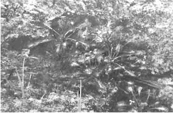
Photo 3: Vegetated sand dunes along eastern portion of Ile Parisienne.
(Photo by MNR; July 2003)
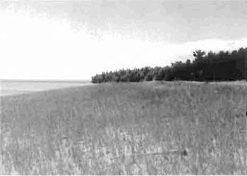
Photo 4: Pitcher-plants (Sarracenia purpurea L.) populate wetland areas within this site.
(Photo by S. Walsh; July 2003)
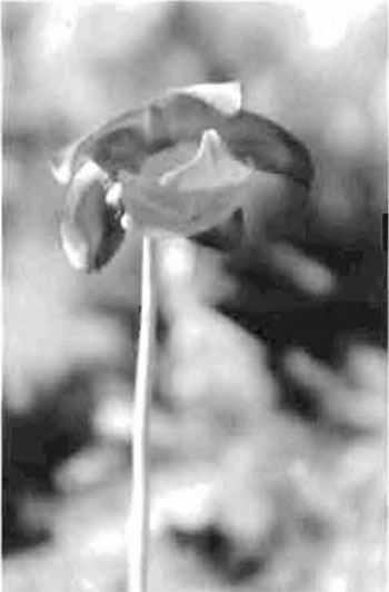
Photo 5: Jacobsville Sandstone shoals surrounding Ile Parisienne.
(Photo by s. Walsh; September 2003)

Photo 6: Provincially significant Jacobsville Sandstone cobble and pebble beaches of Ile Parisienne.
(Photo by s. Walsh; July 2003)

Photo 7: Swirls in Jacobsville Sandstone bluffs, along the west shoreline of the island.
(Photo by P. Kor; July 2003)
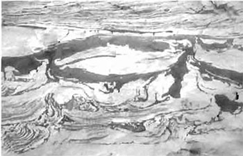
Photo 8: Eastern smooth green snake (Liochlorophis vernalis borealis)
(Photo by M. Hall; July 2003)
Appendix C: Test of compatibility
Test of compatibility
The Conservation Reserve policy provides broad direction with regard to the permitted uses. The policy provides only an Indication of the variety of uses that will be considered acceptable in conservation reserves. Any new uses, and commercial activities associated with them, will be considered on a case by case basis, and, subject to the following test of compatibility. To ensure a standard screening process is followed, reviews of all current and new activities will be subject to the screening criteria as specified by the Environmental Assessment Act (R.S.O. 1900, Chapter E.18).
The following outlines the two steps involved in performing a Test of Compatibility. An assessment of current activities would only follow step two, which focuses on the impacts. An assessment of any new activity would consider the impact of the activity and its conformity to the SCI/RMP.
-
Conformity to SCI/RMP: SCI describe values for which an area has been set aside and the range of appropriate uses that will be permitted in the area. SCI may also speak to the acceptability of other 'new' uses currently not occurring in the area.
The first 'test' is: "do proposed new land uses and/or commercial activities conform to the direction of the SCI/RMP for the conservation reserve? Would the new use(s) depart from the spirit of appropriate indicator land uses in the SCI/RMP?"
- Impact Assessment: If the proposed use(s) pass test 1 it is important to determine their impact on the area before they are approved. This should include the following:
- Impact on natural heritage values: "will the new use(s) impact any natural values in the area? If so how and to what degree? Is it tolerable?"
- Impact on cultural values: "will the new use(s) impact an historical or archaeological values in the area?"
- Impact on research activities: "will the new use(s) affect research activities in the area?"
- Impact on current uses: "will the new use(s) have any negative impact on the array of current uses?"
- Impact on area administration: "will the new use(s) increase administrative costs and/or complexity?" (For example, the cost of area monitoring, security and enforcement).
- Impact on accommodating the use outside the conservation reserve: "Could the use(s) be accommodated as well or better outside the conservation reserve?"
- Impact on socio-economics of the area: "will the new use(s) affect the community(ies) surrounding the area in a positive or negative way?" (For example, will the new use make an area less remote thereby affecting a local tourism industry that is dependent on the area’s remoteness for its appeal?"
- Impact on area accessibility: "does the new use(s) give someone exclusive rights to the area or a portion of the area to the exclusion of other existing uses?"
Appendix D: Summary of permitted uses
The following Policy Report was obtained from the Crown Land Use Policy Atlas website during completion of this SCI (February, 2005). Changes may have been made to this policy report since that time. For the most recent version of this policy report, please refer to the Crown Land Use Policy Atlas on the Internet at /page/crown-land-use-policy-atlas or contact your local Ministry of Natural Resources office.
Crown Land Use Policy Atlas - policy report
C307
Ile Parisienne
Updated: January 16, 2004
Identification:
ID: C307
Area Name: Ile Parisienne
Area (ha): 4,669
Designation: Conservation Reserve (Ontario’s Living Legacy)
MNR District(s): Sault Ste. Marie
Description:
Foreshore flats (shoals) consisting of Precambrian-aged Jacobsville Sandstone bedrock occur along the entire western side of Ile Parisienne. Small vegetated dunes are located along the backshore of the southeast tip of the island, and small unvegetated patches probably represent abandoned beach ridges. A sandy beach with dunes along its backshore occurs along the southwest side of the island, near the lighthouse. Abandoned (raised) postglacial Algoma stage beaches and swales also occur inland from the present shore. Large boulders are interspersed along the shallow waters off the western shore of Ile Parisienne, the result of winnowing of the original glacial sediments on the island over the last 3000 years by storm waves. Seasonal Lake Trout spawning occurs in the waters surrounding Ile Parisienne and the Pansienne Shoal, typically beginning in October. Waterfowl use the shore area along the northeast side for breeding, nesting, and feeding. Raptors and shorebirds use the interior and shores for breeding and feeding.
There is a Department of Transport lighthouse and some associated buildings located at the south shore of the island. Ile Parisienne has been used as protection from Lake Superior storms by commercial traffic for over 100 years and by all lake travelers for centuries This conservation reserve is in Site District 4E-2.
This area is located within the Great Lakes Heritage Coast Signature Site, one of 9 such areas featured in the Ontario’s Living Legacy Land Use Strategy (1999). Signature Sites are identified for their range of natural and recreational values and their potential to contribute to future recreation and tourism.
Ile Parisienne was regulated as a conservation reserve on April 6, 2001.
Land use intent:
Management of this area is also governed by the general policies contained in the Land Use Strategy (1999)
Management direction:
Those uses and management activities not listed in the following table are governed by existing conservation reserve policy. Over time the management direction will be elaborated in a Statement of Conservation Interest or Resource Management Plan. Any new uses, and commercial activities associated with conservation reserves, will be considered on a case by case basis, and they must pass a test of compatibility to be acceptable.
Compatibility is normally determined through a planning process.
| Activity | Permitted | Guidelines |
|---|---|---|
| Aggregate Extraction | No | |
| Bait Fishing Existing: | Yes | Existing use permitted to continue, unless there are significant demonstrated conflicts. |
| Bait Fishing New: | Maybe | New operations can be considered, subject to the "test of compatibility" |
| Commercial Fishing Existing: | Yes | Existing use permitted to continue, unless there are significant demonstrated conflicts. |
| Commercial Fishing New: | Maybe | New operations can be considered, subject to the "test of compatibility". |
| Commercial Fur Harvesting Existing: | Yes | Existing use permitted to continue, unless there are significant demonstrated conflicts. Existing trap cabins can continue; new cabins are not permitted. |
| Commercial Fur Harvesting New: | Maybe | New operations can be considered, subject to the "test of compatibility". |
| Commercial Hydro Development | No | |
| Commercial Timber Harvest | No | |
| Commercial Tourism Existing: | Yes | Existing authorized facilities can continue, unless there are significant demonstrated conflicts. |
| Commercial Tourism New: | Maybe | New tourism facilities can be considered during the planning for an individual reserve. |
| Bear Hunting by Non residents (guided) Existing: | Yes | Existing authorized operations permitted to continue. |
| Bear Hunting by Non residents (guided) New: | No | New operations not permitted. |
| Outfitting Services Existing: | Yes | Existing authorized operations permitted to continue. |
| Outfitting Services New: | Maybe | New operations can be considered during the planning for an individual reserve. |
| Outpost Camps Existing: | Yes | Existing authorized facilities permitted to continue. |
| Outpost Camps New: | Maybe | New facilities can be considered during the planning for an individual reserve. |
| Resorts/lodges Existing: | Yes | Existing authorized facilities permitted to continue. |
| Resorts/lodges New: | Maybe | New facilities can be considered during the planning for an individual reserve. |
| Energy Transmission and Communications Corridors Existing: | Yes | These facilities should avoid conservation reserve lands wherever possible. |
| Energy Transmission and Communications Corridors New: | No | |
| Food Harvesting (Commercial) Existing: | Maybe | |
| Food Harvesting (Commercial) New: | Maybe | |
| Mineral Exploration and Development | No | |
| Peat Extraction | No | |
| Wild Rice Harvesting Existing: | Yes | |
| Wild Rice Harvesting New: | Maybe |
Land and resource management activities
| Activity | Permitted | Guidelines |
|---|---|---|
| Crown Land Disposition Private Use: | Maybe | |
| Crown Land Disposition Commercial Use: | Maybe | Sale of lands is not permitted, except for minor dispositions in support of existing uses (e.g. reconstruction of a septic system). Renewals of existing leases and land use permits are permitted. Requests for transfer of tenure will be considered in the context of the Statement of Conservation Interest or Resource Management Plan. New leases or land use permits permitted for approved activities. Tourism facilities can apply to upgrade tenure from LUP to lease. |
| Fire Suppression | Yes | Fire suppression policies are similar to adjacent Crown lands, unless alternative fire policies have been developed through a planning process. |
| Fish Habitat Management | Maybe | |
| Fish Stocking | Maybe | Existing authorized operations permitted to continue. New operations not permitted. |
| Inventory/disease Suppression | Maybe | |
| Inventory/Monitoring | Maybe | |
| Prescribed Burning Roads (Resource Access) Existing: | Yes | |
| Prescribed Burning Roads (Resource Access) New: | Maybe | Existing roads can continue to be used. Continued use will include maintenance and may include future upgrading. New roads for resource extraction will not be permitted, with the exception of necessary access to existing forest reserves for mineral exploration and development. |
| Vegetation Management | Maybe | Conservation Reserves policy indicates that Featured Species Management and Natural Systems Management may be permitted. Vegetation management can be considered in a planning process. |
| Wildlife Population Management | Maybe |
Science, education and heritage appreciation
| Activity | Permitted | Guidelines |
|---|---|---|
| Collecting | No | |
| Historical Appreciation | Yes | |
| Nature Appreciation | Yes | |
| Photography and Painting | Yes | |
| Research | Yes | |
| Wildlife Viewing | Yes |
Recreation activities and facilities
| Activity | Permitted | Guidelines |
|---|---|---|
| All Terrain Vehicle Use On Trails: | Yes | Existing use permitted to continue where it does not adversely affect the values being protected. ATV use off trails is not permitted except for direct retrieval of game. |
| All Terrain Vehicle Use Off Trails: | No | |
| Campgrounds | Maybe | |
| Food Gathering | Yes | |
| Horseback Riding(trail) | Yes | Existing use on trails permitted. |
| Hunting | Yes | |
| Mountain Bike Use | Yes | Existing use on trails permitted. |
| Motor Boat Use Commercial: | Yes | |
| Motor Boat Use Private: | Yes | |
| Non-motorized Recreation Travel | Yes | |
| Private Recreation Camps (Hunt Camps) Existing: | Yes | Existing camps permitted to continue, and may be eligible for enhanced tenure, but not purchase of land. |
| Private Recreation Camps (Hunt Camps) New: | No | |
| Rock Climbing | Maybe | |
| Snowmobiling On Trails: | Yes | Existing use permitted to continue where it does not adversely affect the values being protected. |
| Snowmobiling Off Trails: | Maybe | Snowmobile use off trails is not permitted, except that snowmobiles may be used for direct retrieval of game. |
| Sport Fishing | Yes | |
| Sport Fishing Trail Development Existing: | Yes | Development of trails for a variety of activities (e.g. hiking, cross-country skiing, cycling, horseback riding, snowmobiling) can be considered as part of planning for an Individual reserve. |
| Sport Fishing Trail Development New: | Maybe |
Note: The policies outlined in this table do not supersede any Aboriginal or treaty rights that may exist, or other legal obligations.
Management of this conservation reserve is carried out within the context of Conservation Reserve policy as amended by the policies for new conservation reserves outlined in the Ontario’s Living Legacy Land Use Strategy.
Source of direction:
Ontario’s Living Legacy Land Use Strategy (1999)
Conservation Reserves Policy (1997)
Explanation of edits:
None
Appendix E: Regulation public consultation materials
Note that some information in these materials is no longer current- the documents are provided here as a matter of historical record.
September 1, 2000
To: Ontario Living Legacy stakeholders
Dear Sir/Madam:
On July 16, 1999, the Ontario Government released the Ontario’s Living Legacy Land Use Strategy, a broad land use approach to the planning and management of much of the Crown lands in central and parts of northern Ontario. A major part of the Ontario’s Living Legacy Land Use Strategy was a government commitment to the biggest expansion of provincial parks and conservation reserves in Ontario’s history. Ontario intends to add 378 new areas to its protected areas system. Ontario’s Living Legacy is a momentous achievement that will be recognized around the world as a significant contribution to sustaining our natural environment. A copy of the Land Use Strategy is available from our office upon request.
In accordance with the recommendations in the Land Use Strategy, the Ministry of Natural Resources is now implementing the process of establishing these 378 new protected areas. The first step in this process is for the Ministry to consult on the boundaries of these areas. In November 1999, MNR held boundary consultations on 64 sites across the OLL Planning Area. Eight of these sites were within Sault Ste. Marie District. At this time, Sault Ste. Marie District has prepared 19 more sites for boundary refinement consultation. Adjacent Districts are consulting an additional two sites, which are also partially contained within Sault Ste. Marie District, on. In future years, the remaining recommended protected areas from the Land Use Strategy will be put forward for similar consultations.
As stated in the Land Use Strategy, the boundary refinement process will consider local ecological information and will attempt to establish regulated boundaries along features that can be identified on the ground. The boundary refinement process may result in modest increases or decreases in the sizes of the protected areas. Any existing commitments for the areas, which were considered during the land use planning process, will be considered in defining the final boundary.
Following is a list of the 21 sites in SSM District scheduled for boundary consultation this year. These sites include both provincial parks and conservation reserves. The Land Use Strategy established the Ministry’s intent to add these Crown lands to Ontario’s protected areas system, following the extensive public consultation associated with Ontario’s Living Legacy and the Lands for Life land use planning initiatives between 1997 and 1999. The Ministry is inviting public comment on the proposed boundaries of these protected areas prior to their finalization and ultimate regulation under the Provincial Parks Act or the Public Lands Act.
- C227 - Glen Crombie Conservation Reserve
- P238 - Mississagi River Provincial Park Additions
- C243 - Wagong Lake Forest Conservation Reserve
- C244 - Rawhide Lake Conservation Reserve
- C246 - Echo River Hardwoods Conservation Reserve
- P253 - Goulais River Provincial Park
- C256- Basswood Lake Hemlock Conservation Reserve
- C258 - Thessalon River Delta I Rock Lake Red Oak Conservation Reserve
- C260- Rose Lake Dune Peatland Complex Conservation Reserve
- C262 - Stuart Lake Wetland Conservation Reserve
- P273- Algoma Headwaters Provincial Park
- P274 - Wenebegon River Provincial Park
- P277 - Aubinadong - Nushatogaini Rivers Provincial Park
- P278- Pancake Bay Provincial Park Additions
- P282 - Batchawana River Provincial Park
- P285 - Sandy Islands Provincial Nature Reserve
- C289 - Searchmont South Forest Conservation Reserve
- C291 - Goulais River Beach Ridges Conservation Reserve
- P292 - Lake Superior Provincial Park Additions
- C307 - Ile Parisienne Conservation Reserve
Your name and address have been included within a Ministry mailing list of persons potentially interested in these boundary consultations. The mailing list includes a range of individuals and groups, such as nearby landowners, resource users, persons with other rights or tenure (e.g. land use permit, Mining Act rights), municipalities, and others who may have an interest in the area. Accompanying this letter, you will find background information (factsheets, maps) for the site(s) we have determined to be of interest to you. More detailed maps and information about the proposed boundaries for all 21 sites are available from this office, or from the Blind River Area Office, 62 Queen Ave., Blind River.
In the future and subject to the intended regulation of these areas as provincial parks and conservation reserves, Ontario Parks and the Ministry of Natural Resources will undertake a management planning process to determine the long-term management of these protected areas. Depending upon the complexity of issues related to the provincial parks, management planning may take the form of a simple Interim Management Statement or a more detailed Park Management Plan. In the case of planning for conservation reserves, a simple Statement of Conservation Interest or a more detailed Resource Management Plan will result. Please let us know if you would like to be notified when planning begins.
Planning, management and permitted uses within these provincial parks and conservation reserves would be consistent with the commitments of the Ontario’s Living Legacy Land Use Strategy.
The Ministry is collecting comments and information regarding these proposed provincial park and conservation reserve boundary reviews under the authority of the Provincial Parks Act and the Public Lands Act respectively. These comments will assist the Ministry in making decisions and determining further public consultation needs. Comments and opinions will be kept on file and may be included in study documentation that is made available for public review. Under the Freedom of Information and Protection of Privacy Act (1987), personal information will remain confidential unless prior consent is obtained. However, the Ministry may use this information as public input on other resource management surveys or projects. For further information regarding this Act, please contact Paul Glassford, A/Information Management Supervisor, Ministry of Natural Resources, Sault Ste. Marie District (705-949-1231).
If you would like to discuss the proposed boundaries and the protection of these areas under the Provincial Parks Act and/or the Public Lands Act, please contact Erin Nixon, District Planner, Ministry of Natural Resources, 64 Church Street, Sault Ste. Marie, Ontario, P6A 3H3; telephone 705-949-1231 ext. 247, fax 705-949-6450, by October 6, 2000. Further information on Ontario’s Living Legacy is available in our office or by visiting the Ministry’s internet website at /ministry-natural-resources-and-forestry.
Thank you for your interest.
Yours sincerely,
Dick Hagman
A/District Manager
Sault Ste. Marie District
Attachments-
Provincial Park and/or Conservation Reserve Factsheet(s)
Proposed Site Boundary Map(s)
Key Map
Permitted Uses Table(s) for Provincial Parks and/or Conservation Reserves
Ile Parisienne Conservation Reserve (C307) fact sheet
September 2000
Background
On July 16, 1999, the Ontario Government released Ontario’s Living Legacy Land Use Strategy to guide the planning and management of Crown lands in central and parts of northern Ontario. A major part of Ontario’s Living Legacy Land Use Strategy was a government intent to establish 378 new protected areas. This commitment marks the biggest expansion of provincial parks and conservation reserves in Ontario’s history.
The proposed Ile Parisienne Conservation Reserve is part of this significant expansion of Ontario’s protected areas system. Following public and First Nations consultation in late 2000 and early 2001 on refining the boundary on this protected area, Ontario Regulation 805/94 of the Public Lands Act was amended on April 6, 2001 by Ontario Regulation 86/01, to formally establish this conservation reserve
Size and Location
Approximately 25 km northwest of Sault Ste. Marie, Ile Parisienne is an island conservation reserve located just outside the mouth of the Goulais Bay in Lake Superior. The conservation reserve is about 933 ha in area, and encompasses all Crown land on the island. Additionally, a 1.6 km water zone has been added to protect the island’s offshore area and shoals.
Area highlights
The Ile Parisienne Conservation Reserve is located within ecological site district 4E-2. This site district extends approximately 60-90 km inland from the eastern shore of Lake Superior and is characterized by rugged topography and elevations exceeding 450 m. Exposed bedrock is common and dates back billions of years to the Precambrian and Cambrian periods.
The western coast of Ile Parisienne is characterized by foreshore flats consisting of Precambrian-aged Jacobsville Sandstone bedrock. Small vegetated dunes are located along the backshore of the southeast tip of the island, and small unvegetated patches probably represent abandoned beach ridges. A sandy beach with dunes along its backshore occurs along the southwest side of the island, near the lighthouse. Ancient beach ridges and swales also occur inland from the present shore. Large boulders are interspersed along the shallow waters of the western shore of Ile Parisienne, the result of winnowing, by storm waves, of the original glacial sediments on the island over the last 3,000 years.
Seasonal lake trout spawning occurs in the waters surrounding Ile Parisienne and the Parisienne Shoal, typically beginning in October. Waterfowl feed and nest along the island’s north shore, while raptors and shorebirds, including colonial nesters, are also common inhabitants of the island. Shore associated mammals such as muskrat, mink, and beaver are also part of the island’s ecosystem.
Isle Parisienne has provided shelter to lake travellers for centuries, and has been used as protection from Lake Superior storms by commercial traffic for more than 100 years.
Land use intent
Conservation reserves are areas of Crown land set aside by regulation under the Public Lands Act. Conservation reserves complement provincial parks in protecting representative natural areas and special landscapes. Most recreational (e.g. hiking, skiing, tourism related uses, nature appreciation) and non-industrial (e.g. fur harvesting, commercial fishing and bait harvesting) activities that have traditionally been enjoyed in the area will continue, provided that these uses do not impact on the natural features needing protection. Hunting and fishing are permitted within all new conservation reserves recommended through Ontario’s Living Legacy.
Commercial timber harvesting, mining, aggregate extraction and commercial hydroelectric development are prohibited in conservation reserves. Careful mineral exploration may occur in specific new conservation reserves proposed through Ontario’s Living Legacy, in areas that have provincially significant mineral potential. If a portion of a new conservation reserve is to be developed for a mine, it would be removed from the reserve, and appropriate replacement lands would be placed in regulation. Please refer to Table 4 from the Land Use Strategy for a detailed summary of permitted uses in conservation reserves.
Next steps
The Land Use Strategy established the Ministry’s intent to add these Crown lands to Ontario’s protected areas system, following the extensive public consultation associated with the Ontario’s Living Legacy and Lands for Life land use planning initiatives between 1997 and 1999. Prior to the finalization of the boundary of this conservation reserve proposed for regulation under the Public Lands Act, the Ministry is inviting public comment on the proposed boundary from all potentially affected stakeholders and First Nations from September 1 to September 30, 2000.
In the interim, the area has been withdrawn and protected from resource extraction activities such as timber harvesting, hydroelectric development, aggregate extraction and new mineral exploration.
In the future and subject to the intended regulation of the area as a conservation reserve, the Ministry of Natural Resources will prepare a long term management plan for this area. Depending upon the complexity of issues within this conservation reserve, management planning may take the form of a simple Statement of Conservation Interest or a more detailed Resource Management Plan. Please let us know if you would like to be notified when planning begins.
Planning, management and the uses permitted within this conservation reserve will be consistent with the commitments of the Ontario’s Living Legacy Land Use Strategy.
For more information
For further information on the proposed Ile Parisienne Conservation Reserve, please contact Erin Nixon, District Planner, Ministry of Natural Resources, Sault Ste. Marie District (705-949-1231 ext. 247). You may also visit the Ministry’s internet website at /ministry-natural-resources-and-forestry for information about Ontario’s Living Legacy.
64 Church Street
Sault Ste. Marie, ON P6A 3H3
August 22, 2001
Regulation of Ontario’s Living Legacy Protected Areas in Sault Ste. Marie District
In July 1999, the Ontario Government released the Ontario’s Living Legacy Land Use Strategy, a broad land use approach to the planning and management of Crown lands in central and parts of northern Ontario. A large component of the Ontario’s Living Legacy Land Use Strategy was a government commitment to add 378 new provincial parks and conservation reserves to Ontario’s protected areas system.
In November 1999 and again in September 2000, we provided you with the opportunity to comment on the proposed boundaries for the park and the conservation reserves in Sault Ste. Marie District. I am pleased to inform you that, as of January 2001, the park and fifteen of these conservation reserves have been regulated. The new park and conservation reserves in the District are:
- P285 Sandy Islands Provincial Nature Reserve
- C243 Wagong Lake Forest Conservation Reserve
- C244 Rawhide Lake Conservation Reserve
- C245 Jollineau Conservation Reserve
- C246 Echo River Hardwoods Conservation Reserve
- C258 Thessalon River Delta/Rock Lake Red Oak Conservation Reserve
- C260 Rose Lake Dune Peat/and Complex Conservation Reserve
- C262 Stuart Lake Wetland Conservation Reserve
- C263 Garden Lake Forest Conservation Reserve
- C281Tilley Creek West Conservation Reserve
- C284 Wabos North Conservation Reserve
- C286 Wabos South Conservation Reserve
- C289 Searchmont South Forest Conservation Reserve
- C294 O'Connor Conservation Reserve
- C298 Harmony Forest Conservation Reserve
- C307 1le Parisienne Conservation Reserve
Regulation means the park and conservation reserves are now legally mapped and recognized as protected areas of crown land under the jurisdiction of the provincial government. As such, these areas will be protected from industrial activities, including commercial forestry, hydroelectric development, mining, and aggregate and peat extraction. Traditional recreational and resource uses such as hunting, fishing, hiking, canoeing, boating, and fur trapping, will generally be permitted to continue within the conservation reserves. In nature reserve class provincial parks (eg. P285, Sandy Islands), hunting and fur trapping are not permitted; other traditional recreational uses (fishing, hiking, canoeing, boating) may continue.
Ontario Parks staff is responsible for the planning and management of Sandy Islands Provincial Nature Reserve and they will prepare an Interim Management Statement to guide the management of this property. Sault Ste. Marie District is responsible for the management of the conservation reserves and will develop Statements of Conservation Interest (SCI) to guide the management of each new conservation reserve. There will be opportunity for the public to review and comment on draft SCI is for each conservation reserve. Depending upon the complexity of issues related to the sites and their management, more detailed Management Plans may, in due course, be required.
Detailed maps of the regulated boundaries for these new protected areas are available for viewing in the Sault Ste. Marie District office and the Blind River Area office of the Ministry of Natural Resources.
If you have any questions or concerns about the management of Sandy Islands Provincial Nature Reserve, please contact Chris Caldwell, Ontario Parks at the Sault Ste. Marie District Office. Concerns regarding any of the conservation reserves should be addressed to Sheila Walsh (OLL Resource Planner) also at the Sault Ste. Marie District Office.
Thank you for your interest in Ontario’s Living Legacy.
Yours truly,
Tom Mispei-Beyer
A/District Manager
Sault Ste. Marie District
Telephone: 705-949-1231
Facsimilie: 705-949-6450
E-mail: tom.mispelbeyer@mnr.gov.on.ca
Appendix F: Amendments to the SCI
Footnotes
- footnote[1] Back to paragraph Ecological site districts are areas characterized by physiographic similarities, and by the successional trends exhibited by the predominant vegetation types on those physiographic features (Hills 1959). See Section 5.0 for more details.
- footnote[2] Back to paragraph Mixed woods are defined as follows: hardwood mixed woods are stands dominated by hardwoods with less than 30 percent cover conifer in the main canopy (vice versa for conifer mixedwoods); mixedwoods contain approximately equal percentages of conifer and hardwood trees; and true mixedwoods contain a 50:50 split between conifers and hardwoods (Nicholson et.al. 2003).
- footnote[3] Back to paragraph Stocking is defined as a qualitative measure of the density of tree cover in a forest stand. Stocking represents the density of forest stems based on average age, height, and the working group (the dominant tree species) in a forest stand. (OMNR 2001a).