Kakakiwibik Esker Conservation Reserve Management Statement
This document provides policy direction for the protection, development and management of the Kakakiwibik Esker Conservation Reserve and its resources.
Statement of Conservation Interest for the Kakakiwibik Esker Conservation Reserve (C1518)
Ontario Ministry of Natural Resource (OMNR)
Wawa District
July 2002
(Revised October 2004)
Approval statement
I am pleased to approve this Statement of Conservation Interest (SCI) for the Kakakiwibik Esker Conservation Reserve (C1518).
Direction for establishing, planning and managing conservation reserves is defined under the Public Lands Act and current policy. "Ontario’s network of natural heritage areas has been established to protect and conserve areas representative of the diversity of the natural regions of the province, including species, habitats, features and ecological systems which comprise that natural diversity." (Policy PL 3.03.05, OMNR 1997).
This Basic SCI will provide guidance for the management of the conservation reserve and the basis for the ongoing monitoring of activities. More detailed direction at this time is not anticipated. Should significant facility development be considered or complex issues arise requiring additional studies, more defined management direction or special protection measures a more detailed conservation reserve Resource Management Plan (RMP) will be prepared with full public consultation.
The public was consulted prior to Kakakiwibik Esker Conservation Reserve’s regulation in November 1999. This Draft Basic SCI was reviewed by the Local Citizens Committee. Comments and concerns registered then are reflected in this Statement of Conservation Interest. This document was prepared with input from the Wawa District Information/Resource Management Team and a draft was provided to the OMNR Regional Planning Unit for review.
The conservation reserve will be managed under the jurisdiction of the Wawa Area Supervisor of the Ministry of Natural Resources, Wawa District.
Submitted by:
Original signed by Angela Anderson for:
Jordan Burkitt
Plan Author
Date:
November 9, 2004
Co-Authored by:
Original signed by Angela Anderson for:
Melanie Stranges
Plan Author
Date:
November 9, 2004
Original signed by:
Terry Taylor
District Manager Recommendation
Date:
November 1, 2004
Approved by:
Original signed by Rob Galloway
Regional Director
Northeast Region
Date:
November 15, 2004
1.0 Introduction
The Kakakiwibik Esker Conservation Reserve is a 522 hectare site that was regulated as a Conservation Reserve (CR) in January, 2001 (Figure 1). The site was recommended for Conservation Reserve status in the Ontario’s Living Legacy Land Use Strategy approved in July 1999, as well as the Crown Land Use Policy Atlas. In late 1999, prior to regulation, consultation on boundary refinement was conducted with the current SFL holder Domtar Inc., local First Nations and the general public. Since public consultation regarding boundary refinement of the site generated little interest and higher level planning documents provide direction on most activities in the reserve, a more detailed Resource Management Plan is not required.
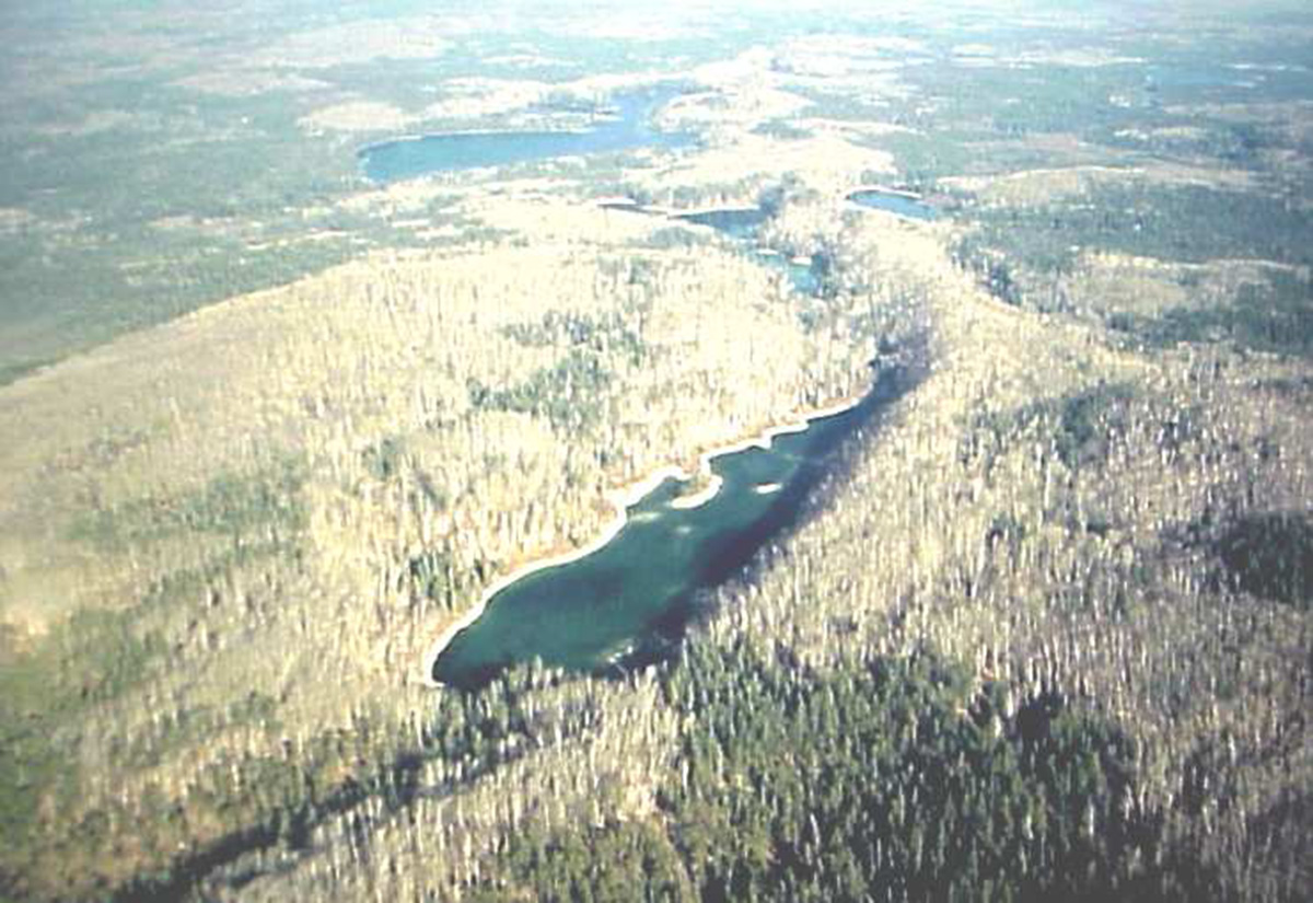
Figure 1: Aerial Photograph of Kakakiwibik Esker

Enlarge Figure 1: Aerial Photograph of Kakakiwibik Esker
The reserve is located approximately 11 km southeast of the town of White River, at the Depew River Bridge on Highway 17 in Abraham and Vasiloff Townships (Figure 2). This site exhibits extensive areas of ice-contact stratified drift deposits and features a significant esker-kame-outwash complex (Geddes and Kristjannson, 1986). A well-defined esker ridge extends across the conservation reserve from the northwest to the southeast. It is associated with a number of tributary esker ridges, long narrow kettle troughs and kame hills adjacent to the troughs. Several lakes have formed in the kettle troughs, which display an unusual blue-green colour that can be attributed to the presence of fine, suspended glacial sediments (Geomatics International Inc., 1995). The Kakakiwibik Esker Conservation Reserve is situated within the Superior section of the Boreal Forest Region (Rowe, 1972) and provides good representation of upland deciduous forest and dry coniferous forests, typical of this forest region (Poser, 1992).
The purpose of this Statement of Conservation Interest (SCI) is to identify area values and provide clear direction on management activity and appropriate land uses within the regulated area. Conservation reserves complement provincial parks in protecting representative natural areas and special features. Most recreational activities (e.g. hiking, nature appreciation, sport hunting and fishing) are permitted, provided they do not impact the natural features being protected. Mining, hydroelectric power development and commercial forestry are prohibited by legislation and the approved Ontario’s Living Legacy Land Use Strategy (OMNR, 1999) guides many other activities.
The Kakakiwibik Esker CR helps to contribute to the representation of the province’s ecosystems and natural features. The addition of the protected areas recommended by Ontario’s Living Legacy will help complete the Provincial Parks system within the planning area and protect 12% of its land and water base.
2.0 Goals and objectives
2.1 Goals of Conservation Reserves
The goal of conservation reserves is to protect natural heritage and cultural values on public lands while permitting compatible land use activities.
2.2 Objectives of Statement of Conservation Interest
2.2.1 Short term objectives
The short-term objectives are:
- To identify the state of the resource with respect to natural heritage values and current land use activities for the conservation reserve
- To manage the conservation reserve to protect the integrity of its natural values via specific guidelines, strategies and prescriptions detailed in this plan
2.2.2 Long term objectives
The long-term objectives are:
- To establish representation targets (e.g. future forest conditions) and validate the site as a potential scientific benchmark
- To identify research/client services, and marketing strategies
- To give direction to evaluate future new uses or economic ventures
3.0 Management planning
3.1 Planning context
3.1.1 Planning area
The planning area is defined as the regulated boundary of the conservation reserve as illustrated in Figure 2. For purposes of Resource Management Planning for other land uses, particularly for Forest Management Planning, the boundary of the conservation reserve in itself will not be treated as a 'value'. Management Prescriptions presented in this plan will relate to the activities within the conservation reserve, will identify the location, shape, size, significance and sensitivity of natural heritage values, and will identify additional special features within the boundary of the site. Management actions outside the boundary of the conservation reserve will continue to consider the site’s natural heritage features, recreational values and protection requirements within larger landscape plans such as Forest Management Plans.
3.1.2 Management planning context
The Kakakiwibik Esker Conservation Reserve and its associated permitted uses will receive its direction from the Ontario’s Living Legacy Land Use Strategy (OMNR, 1999) and subsequent planning direction developed in this plan. By regulation, this reserve cannot be used for mining, commercial forest harvest, hydroelectric power development, peat/aggregate extraction or any other industrial use. The conservation reserve has been withdrawn from the White River Forest Sustainable Forestry License (SFL) and commercial forestry will no longer occur within its regulated boundaries. Since there has been no recent timber harvesting, post harvest silvicultural activities will not be required.
Traditional activities, such as sport fishing and hunting and existing bear management will continue to be permitted. The SCI and future management will attempt to resolve conflicts regarding incompatibility between uses and to ensure that identified values are adequately protected.
At present, there is no land in the CR under land tenure. In the future, land in the conservation reserve will not be sold or leased. New uses and potential commercial activities may be acceptable if they do not impact the natural heritage values of the site. Such activities will be considered on a case-by-case basis and reviewed using the Procedural Guideline B – Land Uses – Test of Compatibility PL 3.03.05 (OMNR, 1997). Authorization for potential compatible uses will be in the form of a Land Use Permit or a Licence of Occupation.
Fish and wildlife management activities will generally occur in a manner similar to surrounding crown lands.
Fire Management is described in Section 6.2.
3.2 Planning process
The level of management planning required to fulfill the protection targets is determined by the complexity of issues that need to be addressed. Guidelines for the preparation of this document are outlined in Procedural Guideline A for SCI and RMP PL 3.03.05 (OMNR, 1997). This SCI will only address known issues or current proposals with respect to permitted uses or potential economic opportunities brought forward during the planning process. Future proposals for development or land use will be reviewed through a Test of Compatibility.
The planning process for the Kakakiwibik Conservation Reserve involves three public consultation phases. In January 2002, notices appeared in the Wawa, Manitouwadge and Marathon newspapers advising that planning for the CR was being initiated and inviting the public and interested organizations to supply background information and view points. There was also a direct mail out to the public and to organizations known to be interested in or affected by the conservation reserve at this time.
The draft SCI will be forwarded to individuals or organizations that have participated in the process to date. In addition, newspaper notices have invited anyone interested to request a copy of the draft Statement of Conservation Interest.
The final public consultation phase will be an inspection of the Ontario Ministry of Natural Resources (OMNR)-approved Statement of Conservation Interest. All participants in the planning process will be notified of plan approval and will receive copies of the plan to see how their comments were addressed. Following this consultation, the plan will be implemented.
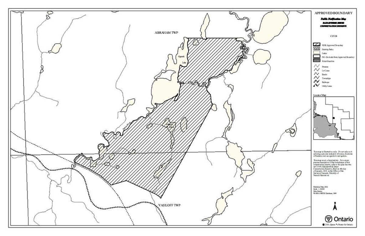
Figure 2: Location of Kakakiwibik Esker Conservation Reserve
Enlarge Figure 2: Location of Kakakiwibik Esker Conservation Reserve
Notices will not be placed on the Environmental Registry because this SCI is not considered a policy under the Environmental Bill of Rights.
4.0 Background information
4.1 Location and site description
4.1.1 Location
The Kakakiwibik Esker Conservation Reserve is situated approximately 11 km southeast of the town of White River, at the Depew River Bridge on Highway 17. Location and administrative information is presented in Table 1.
Table 1: Location and Administrative Details for Kakakiwibik Esker Conservation Reserve
| Territorial District | Algoma |
|---|---|
| OMNR Region/District | Northeast/Wawa |
| Township | Abraham, Vasiloff |
| Eco Region – Eco District (Hills, 1959) | Foleyet Ecodistrict 3E-5 (Hills, 1959; Crins and Uhlig, 2000) |
| Regulation Date | January 2001 |
| Total Area | 522 ha |
| Ownership | Crown |
| UTM Coordinates | 5340500N 637000E |
| Map Number | 42C/11 (White River) |
| Nearest Town/Community | White River |
| OBM Numbers | 166305370, 166305380 |
| Wildlife Management Unit | 22 |
| Forest Management Unit | White River Forest |
4.1.2 Physical description
Kakakiwibik Esker Conservation Reserve is a 522 hectare parcel of Crown land. Access to the site is via Highway 17, which comprises the southwestern boundary of the site or via the Depew River Provincial Canoe Route, which makes up the western and northeast boundaries of the reserve.
The site is considered an area of regional significance due to a number of special features. Effectively, the primary earth science features of the reserve create a record of glacier recession, which occurred in this region approximately 10,000 years ago. The Kakakiwibik Esker is a distinct esker ridge, which extends north-northeast from Highway 17. It exhibits excellent form and is steep-sided with a distinct narrow crest. It is associated with tributary esker ridges, long narrow kettle troughs and kame hills adjacent to the troughs. The Depew River riparian wetlands, kettles and fen-wetland complex are also highlighted features. The pair of blue-green coloured cold-water kettle lakes and trough landforms on the western border of the site is considered unusual for this Site Region (White, 1988). The brilliant colour of these lakes has been attributed to the suspension of fine glacial sediments.
The reserve is located within the Foleyet EcoDistrict 3E-5 Hills (1959); Uhlig & Crins (2000), which is characterized by gently rolling plains of thinly covered rock knobs, sandy outwash and silty depressions. Two areas of bedrock-drift complex are located in the south portion of the reserve. The eastern area is dominated by an isolated bedrock knob or knoll form, which is characterized by minor to moderate bedrock exposure at the crest and thin continuous drift cover at the flank. An extensive area of ice-contact stratified drift deposits dominates the surficial geology of the CR. The narrow belts of ice-contact landforms and sediments are classified as esker-kame-kettle complexes that have "a well developed central esker ridge, which often grades laterally into a sequence of kettled kame terraces and outwash flats" (Geddes and Kristjannson, 1986). The spacing of these esker-kame-kettle belts is approximately equidistant, suggesting a symmetrical and well-integrated meltwater drainage system.
A continuous, somewhat sinuous, sharp-crested esker ridge extends through the conservation reserve from the northwest quadrant to the southeast quadrant and beyond. The portion within the reserve is approximately 4 to 5 km and is part of a much longer esker ridge that reaches into the area immediately north of the reserve. In the southeast quadrant, various oval to linear, irregular-shaped kettle holes are situated immediately adjacent to the esker ridge. In the north, relatively large ice block depressions are associated with the esker ridge. The esker ridge is also associated with at least two relatively extensive, planar to hummocky (i.e. kamiform), fan- shaped sediment bodies, which appear to be the proximal areas of sequential, subaerial outwash fans. The outwash fans are located in the areas east and southeast of southern Oganek Lake and east of northern Oganek Lake.
Glaciofluvial outwash deposits immediately underlie much of the southwest and northeast quadrants. These areas of kettled outwash or stagnant ice block depressions are found directly adjacent to the linear area of the esker-kame-kettle form. Alluvial deposits associated with the Depew River are representative of post-glacial activity. A well-developed alluvial plain is situated within the southwest quadrant. Depressional areas contain organic deposits, which represent the post-glacial accumulation of organic materials under poorly drained conditions.
The Kakakiwibik Esker Conservation Reserve is situated in the Superior section of the Boreal Forest Region as defined by Rowe (1972). Forest types in this region range from mixed-wood with shrub undergrowth to poor, single dominant coniferous forests. Mixed forests of white spruce, balsam fir, white birch and trembling aspen are characteristic of medium-textured valley slopes of the conservation reserve. On till slopes, as well as the tops of low hills, the same association of species is found with birch becoming more prominent and some black spruce appearing. In the valleys and on rocky outcrops, coarse substrate supports jack pine, white birch, spruce, tamarack and occasionally eastern white cedar. Oganek Lake is surrounded by forests of mixed white birch, poplar and jack pine, which grow to the shoreline. A narrow bay approximately midway down the eastern shore of Oganek Lake leads to a shrub thicket corridor that gives way to a small black spruce community. The reserve provides good representation of upland deciduous forests and dry coniferous forests typical of this site region.
The site regional forest climate is mid-humid, warm boreal with soils ranging from humo-ferric podzols to dystric brunisols on dry to fresh and rapidly to well-drained sites. Gleysols and organic soils have formed in poorly drained depressions and on lower slopes.
This reserve is located within the Lake Super Basin 2BC tertiary watershed. In the southwest portion of the site, a wetland complex containing kettle lakes, creeks and open, poor fens exists. Grasses (graminoids) and low shrubs dominate this complex. A treed bog wetland is located at the eastern side of the ridge system. An extensive, moderately rich fen was identified east of Oganek Lake, which contains substantial amounts of larch and cedar, as well as some black spruce. The shores of the Depew River display low shrub shore fen and the presence of dead trees along the banks indicate the possibility of seasonal flooding. A small lake in the southwest corner of the reserve exhibits emergent vegetation and contains sheltered to open water marshlands. A small black spruce bog is located along the north boundary of the reserve.
4.2 Administrative description
The Ontario Ministry of Natural Resources and the Surveyor General of Ontario certified the legal boundaries of the Kakakiwibik Esker Conservation Reserve on January 6, 2001. The site was passed into regulation in January, 2001 (Ont. Reg. 805/94). The conservation reserve is located within the White River Forest Management Unit and the current SFL holder is Domtar Inc.
4.3 History of the site
The Kakakiwibik Esker site has been an area of interest to the Ontario Ministry of Natural Resources since the late 1970's. Portions of the reserve were recommended as a potential Candidate Protected Area in 1983. In 1988, the area was proposed as an Area of Natural and Scientific Interest (ANSI); however, the boundaries of the site were different. The area was defined as an Earth Science Site in the Ontario Living Legacy Land Use Plan (OMNR, 1999). No additional historical or current non-tenure land use of the site is known.
4.4 Inventories
Table 2 illustrates the inventories/surveys completed for Kakakiwibik Esker CR, as well as any future requirements for earth and life sciences, cultural, recreational or other categories. Inventory Checksheets are attached as appendices.
Table 2: Inventory and Survey Information for Kakakiwibik Esker Conservation Reserve
| Survey Level | Earth Science | Life Science | Cultural | Recreational | Other |
|---|---|---|---|---|---|
| Reconnaissance | Completed Fall 2001. Rik Kristjansson Checksheet completed | Completed February 2001. Barb Burkhardt Checksheet completed | Completed December 2001. Shawn Fortin Checksheet completed | ||
| Detailed | |||||
| Requirement |
5.0 State of the resource
Representation:
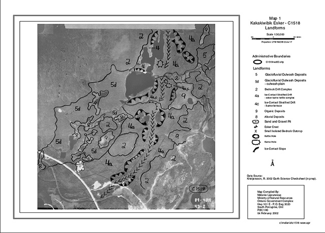
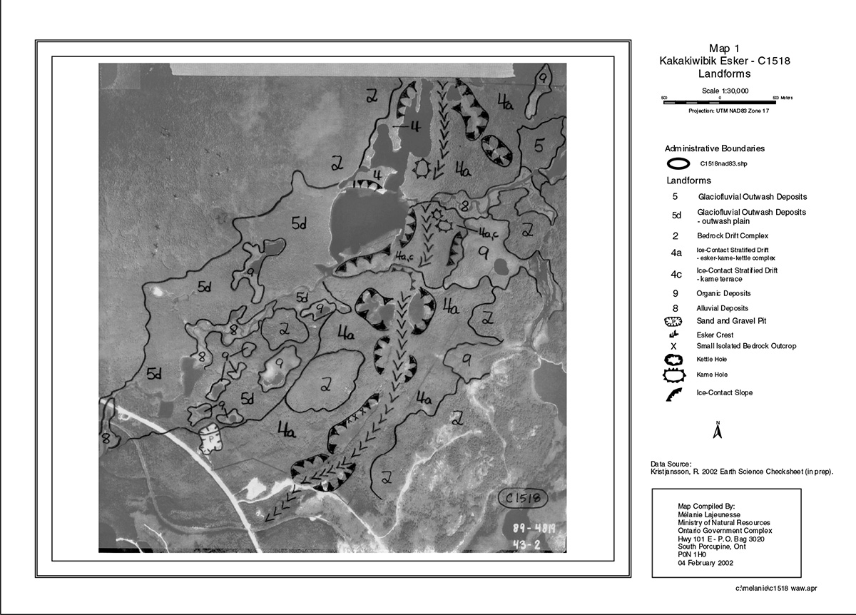
The geological features of Kakakiwibik Esker Conservation Reserve are considered regionally significant and the existing vegetation is considered representative of local landform-vegetation associations (Noble, 1991). The primary features of earth science natural heritage are associated with the extensive areas of ice-contact stratified drift deposits, which immediately underlie most of the conservation reserve (Appendix A – Map 1). The most prominent feature in the reserve is a well-defined central esker ridge, which often grades laterally into a sequence of kettled kame terraces and outwash flats (Geddes and Kristjansson, 1986). A small lateral ice-contact delta lies adjacent to the western side of the esker ridge near Oganek Lake. In the southern section of the site, west of the esker, several lakes have formed in a conspicuous trough. These lakes exhibit a distinct blue-green colour associated with fine, suspended glacial sediments.
Glaciofluvial outwash deposits immediately underlie much of the northeast and southwest quadrants of the reserve and are associated with a variety of depressional areas. Areas of kettled outwash deposits are situated immediately adjacent to the linear area of esker-kame-kettle forms. These depressions contain organic deposits from the post-glacial accumulations of organic materials under poorly drained conditions. The Depew River has to some extent, reworked both the northeast and southwest areas of glaciofluvial outwash deposits. Alluvial deposits associated with the Depew River are representative of this post-glacial activity. Lake in-filling wetlands have developed around a number of kettles in the reserve. A wetland complex exists in the southwest portion of the site, which contains kettle lakes, creeks and open poor fens of grasses (graminoids) and low shrubs. A treed bog can be found on the eastern side of the ridge system, straddling the boundary of the reserve. East of Oganek Lake, a moderately rich fen was identified with substantial amounts of cedar and larch, as well as black spruce. Low shrub shore fen was also noted along the Depew River. In the southwest corner of the reserve, a small lake displayed emergent vegetation and contained sheltered to open water marshlands. In addition, a small black spruce bog is located along the northern boundary of the site and an open bog is situated on an unnamed lake northeast of Oganek Lake.
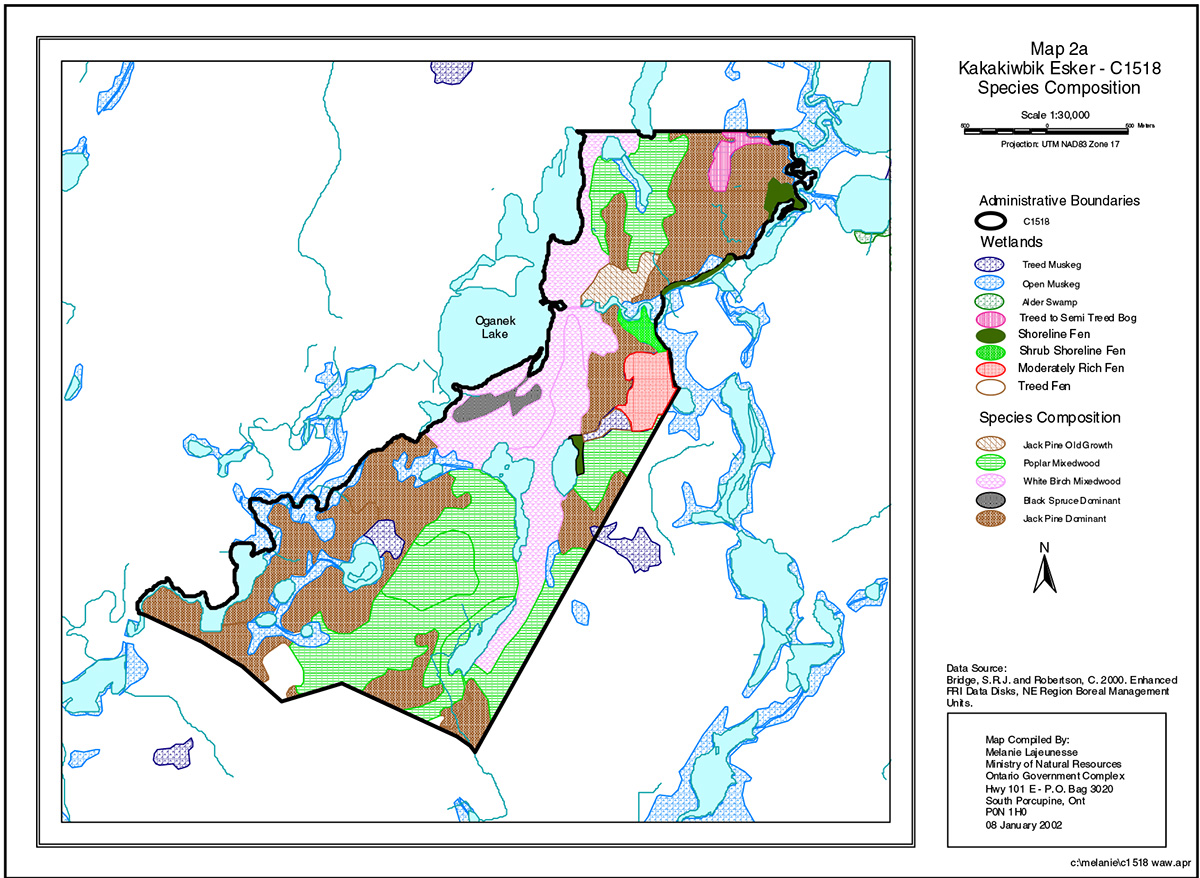
Five separate forest communities were identified within Kakakiwibik Esker Conservation Reserve (Appendix A - Map 2a). Jack pine dominant, white birch mixedwood and poplar mixedwood communities dominate the site. A narrow bay midway down the eastern shoreline of Oganek Lake leads to a small black spruce community and an old growth jack pine community is found north of the Depew River near Oganek Lake (Thompson, 2001).
Kakakiwibik Esker was designated as an Earth Science Site in the Ontario Living Legacy Land Use Plan (OMNR, 1999). Aerial photograph interpretation and aerial reconnaissance survey analysis indicates that this site contains 13 major landform types (Appendix A - Map 1). Examinations of best available FRI data and field notes (Thompson, 2001), as well as Kristjansson’s interpretation revealed a minimum of 42 landform-vegetation combinations are present.
Oganek Lake supports a mixed fishery of walleye and pike. North Oganek Lake and North O'Brien Lake support brook trout fisheries. The native fish population in South O'Brien Lake was eliminated in 1970 by the application of Toxaphene and was subsequently stocked with trout. Over 30 mammalian species are expected to occur in the area; including moose (Alces alces), beaver (Castor canadensis), otter (Lutra canadensis) and marten (Martes americana). A number of bird species inhabit and migrate through the reserve, as well. Great blue herons (Ardea herodias) and common loons (Gavia immer) have been observed on Oganek Lake. Numerous reptiles, amphibians and invertebrates are also present (Geomatics International Inc., 1995).
No cultural heritage or archaeological features are known to exist within the boundaries of the reserve.
Quality of present representation:
The quality of the representation and the current characteristics of the natural features found within the conservation reserve are as important as the overall representative features that are being protected. A number of factors are considered in the evaluation of the site, including; diversity, ecological factors, condition, special features and current land use activities.
a) Diversity:
Diversity is evaluated according to the number and range (variety) of the natural landscape features and landforms for the earth science values and the relative richness and evenness of the life science components. There are 13 major landform or earth science features in the reserve; including the presence of an esker ridge, exposed bedrock and glaciofluvial outwash deposits.
Life science diversity contains a minimum of 42 landform-vegetation combinations. Based on the number of cover types, the level of richness is high for a site of such small area. Jack pine dominant, white birch mixedwood and poplar mixedwood communities are equally represented throughout the site with areas ranging from 135 to 170 hectares. However, most forest communities observed contained a wide assemblage of tree species. Wetland and aquatic values also add to the site’s diversity. Overall, the number of communities present, the lack of dominance by any one community and the interesting orientation of a number of landform- vegetation combinations each contribute to the site’s high life science diversity rating.
The faunal diversity for the site is likely normal for the Boreal Region. Since only a reconnaissance level survey was completed, a more definitive assessment of floral and faunal diversity cannot be made.
b) Ecological factors
Ecological factors are significant to the quality of representation within the reserve and include size, shape, sensitivity to potential disturbances, and current linkages to the larger landscape. The Kakakiwibik Esker CR is relatively small (522 hectares) and contains several vectored boundaries. Vectored boundaries can weaken the site’s ability to protect against adjacent land uses. In the northeastern corner and southwestern section, the boundaries identified for the site follow the Depew River. Highway 17 provides a cultural boundary along the southwest border of the reserve.
The conservation reserve encompasses the subwatershed that feeds Oganek Lake and the wetland associated with the Depew River. This provides an opportunity to protect the water quality and hydrologic regime of both the river system and the wetland. Since wetlands are extremely sensitive to alterations in water level fluctuations, as well as water quality, this is an important consideration in maintaining the riparian wetlands, kettle bogs and fens. Capturing the local watershed is essential for preserving the long-term ecological integrity of the conservation reserve.
From a life science perspective, the design of the site provides moderate protection of the core values. The wetlands, rock outcrops, kame hills, kettle holes and the ice contact slopes are, for the most part, contained within the reserve boundaries. The connection of the site to Oganek Lake’s shoreline also adds to the design of the site. The southern portion of the esker ridge is nested within the boundaries of the reserve; however, this feature extends beyond the northern border. The small area of the site, as well as the presence of vectored boundaries, will continue to make management and protection of the core areas difficult. Additional protection of the both the esker complex and the general conservation of the reserve will have to occur during larger management planning exercises (Forest Management Plans).
c) Condition
In general, the conservation reserve is relatively undisturbed. Based on current Forest Resource Inventory (FRI) data, the jack pine, aspen and birch stands originated approximately 79 years ago after a widespread forest fire occurred in the area (Appendix A - Map 7). Gravel extraction has occurred close to Highway 17 in the southeast and southwest corners of the reserve; however the pits were closed and rehabilitated. Currently the Ministry of Transportation has applied to have the pits removed from the conservation reserve.
d) Special features
Three significant characteristics have been identified in the conservation reserve. The primary feature is the distinct esker ridge, which runs north-northeast from Highway 17 and extends beyond the northern boundary of the site. The Kakakiwibik Esker exhibits excellent form with steep sides and a distinct narrow crest. It is associated with tributary esker ridges and long, narrow kettle troughs, which are now filled with blue-green lakes. Kame hills are also found adjacent to the troughs. These features are relatively undisturbed and are, for the most part, contained within the boundaries of the reserve. The second special feature has been identified as the Depew River riparian wetlands, kettles and fen complex. Finally, the pair of blue-green coloured cold-water kettle lakes near the western border of the esker is considered to be an unusual feature in this Site Region (White, 1998). The brilliant colour of these lakes has been attributed to the presence of fine, suspended glacial sediments.
e) Current land use activities
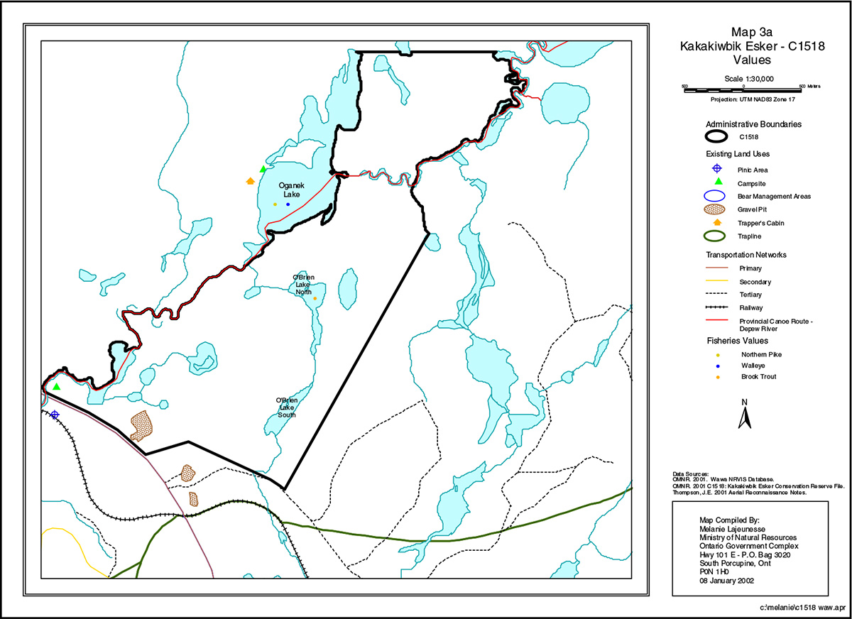
There are currently no mining claims or leases within the reserve boundaries or adjacent to the site. A trapper’s cabin is located west of Oganek Lake, outside the site’s boundaries but the trapline area extends into the reserve. A bear management area is also located within the boundaries and recreational hunting and fishing are common. A small trail follows an abandoned drainage course through the outwash material near the western boundary and is often used by duck hunters to access the kettle ponds found in the southwest portion of the site (Noble, 1991). A highway rest stop and picnic area are located at the Depew River Bridge and a campsite is situated north of Highway 17 (Appendix A - Map 3a). The extent of use of the Depew River Provincial Canoe Route is low.
5.1 Social/economic interest in area
a) Linkage to local communities
The reserve is not physically linked to any other Provincial Park, conservation reserve or community. Oganek Lake is a known recreational fishing location that receives moderate use from resident and non-resident anglers and contributes to the economic viability of nearby campgrounds.
b) Heritage estate contributions
Kakakiwibik Esker CR contributes to the province’s parks and protected areas by preserving a number of natural heritage values. This site exhibits extensive areas of ice-contact stratified drift deposits and features a significant esker-kame-kettle complex. These features are poorly represented in the Eco Region. The wetlands associated with the kettle lakes in the southern portion of the site are excellent examples of lake-fill succession and are considered unusual in this area. The current reserve boundaries capture the local subwatershed, providing an opportunity to protect the water quality and hydrologic regime of both the river system and the wetland associated with the Depew River.
The lack of industrial disturbance in reserve and the minimal level of current land use will help to ensure that fragile vegetations communities, significant geological features and waters are protected into the future. Furthermore, the site’s distinctiveness as a record of glacial recession may distinguish this site as an important scientific benchmark in the years to come. Future managers will have to balance the need to maintain the quality of the current representation and the needs of present and future users.
5.2 Natural heritage stewardship
The Earth Science Checksheet and aerial photo interpretations (Appendix C) for Kakakiwibik Esker CR were completed by Kristjansson (2002). Based on reconnaissance helicopter survey, review of available Quaternary geological mapping and interpretations of relatively recent (1989) aerial photography, 5 earth science features are present:
- Bedrock-Drift Complex
- Ice-contact Stratified Drift Deposits
- Glaciofluvial Outwash Deposits
- Alluvial Deposits
- Organic Deposits
The primary earth science features encompassed by this site represent a record of the style of glacier recession that occurred in this region at the end of the last glaciation.
The Life Science Checksheet was compiled by Lajeunesse and Thompson (2001) and highlights 13 landform units (Appendix A - Map 1):
- Glaciofluvial Outwash Deposits – unsubdivided
- Glaciofluvial Outwash Deposits – outwash plain
- Bedrock-Drift Complex – unsubdivided
- Ice-Contact Stratified Drift Deposits – esker-kame-kettle complex
- Ice-Contact Stratified Drift Deposits – kame terrace
- Organic Deposits – unsubdivided
- Alluvial Deposits – unsubdivided
- Sand and Gravel Pit
- Esker Crest
- Small Isolated Bedrock Outcrop
- Kettle Hole
- Kame Hill
- Ice-Contact Slope
Examinations of best available FRI data and field notes (Thompson, 2001), as well as aerial photograph interpretation (Kristjansson, 2002) revealed a minimum of 42 landform-vegetation combinations are present.
Kakakiwibik Esker Conservation Reserve is located in the Lake Superior Basin 2BC-01 tertiary watershed and the current water resources found within the site are suitable for fish production, both in terms of water chemistry and habitat characteristics. There is no known aquatic contamination within the boundaries of the reserve or adjacent to the site.
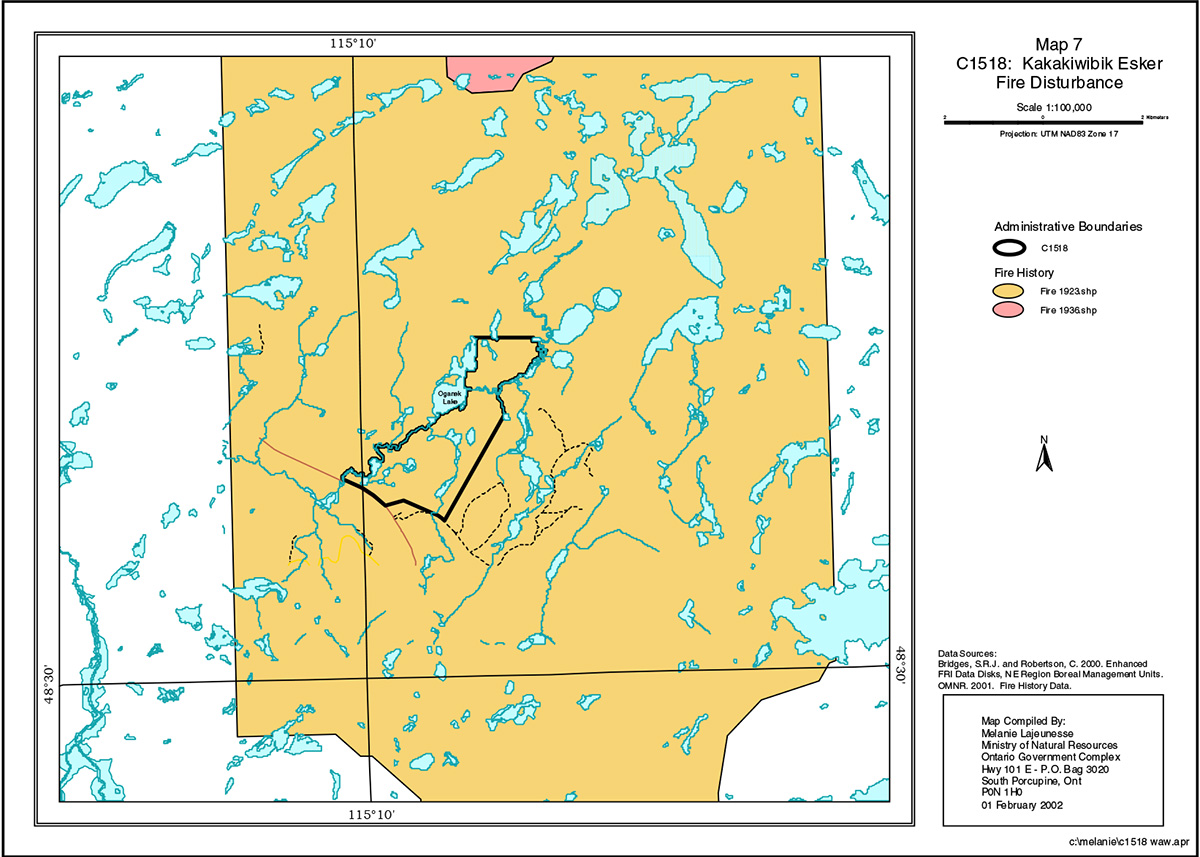
A forest fire recorded in 1923 covered the entire conservation reserve (Thompson, 2001). Wawa District fire records indicate there were fires in the CR during 1976 (0.2 ha) and 1997 (0.1 ha).
5.3 Fisheries and wildlife
Lake surveys indicate that Oganek Lake and O'Brien Lakes exhibit appropriate water chemistry and habitat characteristics for productive fisheries. Oganek Lake supports a mixed fishery of walleye, trout and pike. South O'Brien Lake was stocked with trout following the application of Toxaphene and North O'Brien Lake is currently stocked with trout. The Depew River system also supports walleye and pike.
The fauna in Kakakiwibik CR is typical of the boreal region. There are no known vulnerable, threatened or endangered (VTE) species or species at risk within or adjacent to the site.
5.4 Cultural heritage stewardship
There are no known archaeological heritage values within the site.
5.5 Land use/current or past development
The reserve rests on Crown Land and is unencumbered by any land use permit, leases or mining claims. No further management actions, such as acquisitions or restrictions on existing use, are required. A Ministry of Transportation gravel pit was originally located in the southwest corner of the reserve and has been proposed for removal from the regulated boundary. Bear management area (WA-22-26) exists within the boundaries and recreational hunting and fishing are common. A trapper’s cabin is located west of Oganek Lake, outside the site’s boundaries but the trapline area (WA-28) extends into the reserve.
5.6 Commercial use
As described in the previous section, the area is within a Bear Management Area and a trapline area. Current use can continue and transfers will be permitted.
5.7 Tourism/recreational use/opportunities
A small trail follows an abandoned drainage course through the outwash material near the western boundary and is often used by duck hunters to access the kettle ponds found in the southwest portion of the site (Noble, 1991). A highway rest stop and picnic area are located just outside the CR at the Depew River Bridge and a campsite is situated north of Highway 17. The extent of use of the Depew River Provincial Canoe Route is low.
Tourism proposals will be assessed on a case-by-case basis and approved if compatible with natural values and other uses that may exist at the time (Appendix B).
5.8 Client services
No infrastructure or interpretive facilities are proposed for the site. Informal wildlife viewing and nature appreciation can continue without further development.
6.0 Management guidelines
6.1 Management planning strategies
Commitments identified in current policy (PL 3.03.05 and the OLL Land Use Strategy) will form the basis for the management planning strategies presented within this SCI. Further management direction will be formulated to address short and long term objectives for the reserve. For up to date information on permitted uses refer to the Crown Land Use Atlas.
Proposed uses and development will be reviewed on a case by case basis. However, a Test of Compatibility, Procedure Guideline B – Land Use, Public Lands Act (PL 3.03.05) must be passed before any uses or developments are deemed acceptable. A similar test with a refined scope for environmental issues will be used. For the template, refer to Appendix 9.5, taken from the SCI Test of Compatibility NER Guideline in Planning process for Conservation Reserves Statement of Conservation Interest (SCI) and Resource Management Plans (RMP) Northeast Region Guidelines Version 2.1 September 17, 2001, Appendix 4, page 44. The Test of Compatibility will address, but not be limited to, the proposal’s effect on vegetation, soil, ground and surface water quality and quantity, air quality, critical habitat and any other known representative earth or life science feature. The quality, significance and current sensitivity of any feature will also be addressed.
6.2 State of the resource management strategies
The development and renewal of this SCI will be under the direction of the OMNR's Wawa District, Information Management Supervisor. The implementation of the SCI and long term management and protection of Kakakiwibik Esker Conservation Reserve will be under the direction of Wawa District’s Area Supervisor. The following management strategies have been created to achieve the goal and objectives stated earlier in this management document.
All earth and life science features will be protected by defining compatible uses, enforcing regulations (Ont. Reg. 805/94 PLA) and monitoring and mitigating issues. Industrial activities such as; timber harvesting, prospecting, mining, and new hydro generation will not be permitted within the boundaries of the conservation reserve. Energy transmission, communication and transportation corridors or resource roads or construction of facilities are discouraged, through existing planning process. Exceptions based on a Test of Compatibility may be made for minor structures for Inventory, Assessment, Monitoring and Research.
The Kakakiwibik Esker Conservation Reserve falls within fire management zone 17. The management intent is that the conservation reserve will be managed according to the existing fire management guidelines.
Fire suppression is expected to have an effect on the site’s ecosystems, and this compromises its value as an ecological benchmark against which managed forests can be compared. It may have some value for study of stand development in the absence of fire.
The OMNR recognizes fire as an essential process fundamental to the ecological integrity of conservation reserves. In accordance with existing Conservation Reserve Policy and the Forest Fire Management Strategy for Ontario, forest fire protection will be carried out as on surrounding lands.
Whenever feasible, the OMNR fire program will endeavor to use "light on the land" techniques, which do not unduly disturb the landscape, in this conservation reserve. Examples of light on the land techniques may include limiting the use of heavy equipment or limiting the number of trees felled during fire response efforts.
Opportunities for prescribed burning to achieve ecological or resource management objectives may be considered. These management objectives will be developed with public consultation prior to any prescribed burning, and reflected in the document that provides management direction for this conservation reserve. Plans for any prescribed burning will be developed in accordance with the OMNR Prescribed Burn Planning Manual, and the Class Environmental Assessment for Provincial Parks and Conservation Reserves.
The introduction of exotic and/or invasive species will not be permitted. Programs may be developed to control forest insects and diseases in the conservation reserve where these threaten significant heritage, aesthetic, or economic values. Where control is desirable and possible, it will be directed as narrowly as possible to the specific insect or disease. Biological control will be used wherever possible.
The collection/removal of vegetation and parts thereof will not be permitted. However, subject to a Test of Compatibility, the Area Supervisor may authorize the collection of plants and/or parts for the purposes of rehabilitating degraded sites within the reserve if required and for research or scientific study.
Ontario Ministry of Natural Resources will provide leadership and direction for maintaining the integrity of this site as a natural heritage estate. Research, protection education and understanding and interpretation of the natural heritage features of the site will be encouraged and fostered through local and regional natural heritage programs and initiatives.
Fish and wildlife resources will continue to be managed in accordance with policies and regulations prevailing in the area. Provincial legislation and policies will dictate management and enforcement objectives for this conservation reserve.
Existing trapping, hunting and sport fishing will be permitted by outfitters and the general public. Access by snowmobile and aircraft are still permitted. First Nation treaty rights will be respected. No new commercial outfitting, outpost, hunting camps or new trap cabins will be permitted within the boundaries of the conservation reserve.
At present, there is no need to survey cultural resources, since there is probably a low potential for cultural resources and since any such resources are in no danger of being affected by existing use.
The site has been excluded from the White River Forest Management Unit, but the loss of land base to Domtar Inc. is within the context of Ontario’s Living Legacy, the OLL Forest Accord, and the Living Legacy Trust, all of which support the long term continuity and security of wood supply.
The area may not be heavily used for tourism purposes in the foreseeable future but the Kakakiwibik Esker Conservation Reserve, and the abundance of protected areas in the region will contribute to tourism marketing by local communities.
6.3 Specific feature/area/zone management strategies
There are no known specific features in the reserve that require special attention or management.
6.4 Promote inventory, assessment, monitoring and research
Scientific research by qualified individuals, which contributes to the knowledge of natural and cultural history and to environmental and recreational management, will be encouraged. Research related to the study of natural processes will also be encouraged provided it does not harm the values of the reserve. All research programs will require the approval of the Ontario Ministry of Natural Resources and will be subject to ministry policy and other legislation. Those interested in pursuing research within the conservation reserve must apply to the Area Supervisor for approval. Applications to complete the research will follow guidelines established by Ontario Parks for research within provincial parks (see Appendix 9.6, Procedural Guidelines C – Research Activities in Conservation Reserves from PL 3.03.05) or equivalent direction formulated by the OMNR, Wawa District. Approvals will meet all terms and conditions established by Wawa District Office.
Additional life and earth science inventories are required to refine values and management guidelines. These are considered to be a priority. At this present time, further cultural inventory and assessment is not required.
The ministry may approve on a case by case basis the removal of any natural or cultural specimen by a qualified researcher. All such materials removed remain the property of the Ontario Ministry of Natural Resources.
New research developments will not be considered until a Test of Compatibility is conducted. The Test of Compatibility or environmental screening process could include a review of the demand for structures or may require more detailed life or earth science or cultural information and possibly a more detailed management plan.
6.5 Implementation, and plan review strategies
Implementation of this SCI will primarily involve monitoring activities to ensure adherence to the management guidelines. Other activities will include funding future life and earth science inventories, preparing a fact sheet highlighting the important natural heritage values of the reserve and responding to inquiries about the site.
Implementation of the SCI and management of the reserve are the responsibility of the Area Supervisor. This SCI will be reviewed on an ongoing basis, as there is no formal review or expiry date for the document. If changes in management direction are needed at any time, the significance of the changes will be evaluated. Minor changes, which do not alter the overall protection objectives, may be considered and approved by the Area Supervisor without further public consultation and the plan will be amended accordingly. In assessing major changes, the need for a more detailed Resource Management Plan will first be considered. Where a management plan is not considered necessary or feasible, a major amendment may be considered with public consultation. The Regional Director will approve major amendments.
This SCI or future RMP, if required, plus the Crown Land Use Atlas and associated website (see above) will be amended to reflect any changes in management direction.
6.6 Marketing strategies
Kakakiwibik Esker CR will be marketed as a distinctive natural area having significant earth science values. In this regard, a fact sheet may be prepared to inform the public about these values and their role within the greater parks and protected area system and current access. Marketing efforts to increase use are not a priority at this time and will be kept to a minimum.
7.0 References
Crins, W.J., and P.W.C. Uhlig. 2000. Ecoregions of Ontario: Modifications to Angus Hills' Site Regions and Districts. Revisions and Rationale.
Geddes, R.S. and Kristjansson, F.J., 1986; Quaternary Geology of the White River Area, Districts of Thunder Bay and Algoma; Ontario Geological Survey, Map P.2988, Geological Series - Preliminary Map, Scale 1:50,000. Geology 1983, 1985.
Geomatics International Inc. 1995. A Biological Inventory and Evaluation of the Kakakiwibik Esker – Kame – Fen Complex Candidate Protected Area.
Hills, G.A. 1959. A Ready Reference to the Description of the Land of Ontario and its Productivity. Preliminary Report. Ontario Department of Lands and Forests, Division of Research, Maple. 142 pp.
Kristjansson, Rik. 2002. Earth Science Inventory Checklist and aerial photo interpretation.
Lajeunesse, M. and J.E. Thompson. 2001. Natural Heritage Area – Life Science Checksheet. C1518 – Kakakiwibik Esker Conservation Reserve.
Noble, T. 1991. Assessment of some Life Science Sites in Site Regions 3E and 4E, Northeastern Region. Report prepared for the Ontario Ministry of Natural Resources, Sudbury.
Noble, T. 1991. Kakakiwibik-Esker-Fen Complex Life Science Inventory Checksheet.
OMNR. 1997. Conservation Reserve Policy PL 3.03.05
OMNR. 1999. Ontario’s Living Legacy Land Use Strategy. Queen’s Printer for Ontario.
Poser, S. 1992. Report on the Status of Provincial Parks in the Site Regions and Districts of Ontario.
Rowe, J.S. 1972. Forest Regions of Canada.
Thompson, J.E. 2001. Life Science Sheck-sheets Information Template.
White, D.J. 1988. Statement of Interest for Kakakiwibik Esker Candidate Areal of Natural and Scientific Interest. Parks and Recreational Areas Branch, Ministry of Natural Resources, Northeastern Region.
Appendix A
Map 1: Kakakiwibik Esker (C1518) - Landforms
Enlarge Map 1: Kakakiwibik Esker (C1518) - Landforms
Map 2a: Kakakiwibik Esker (C1518) - Species Composition

Enlarge Map 2a: Kakakiwibik Esker (C1518) - Species Composition
Map 3a: Kakakiwibik Esker (C1518) - Values
Enlarge Map 3a: Kakakiwibik Esker (C1518) - Values
Map 7: Kakakiwibik Esker (C1518) - Fire Disturbance
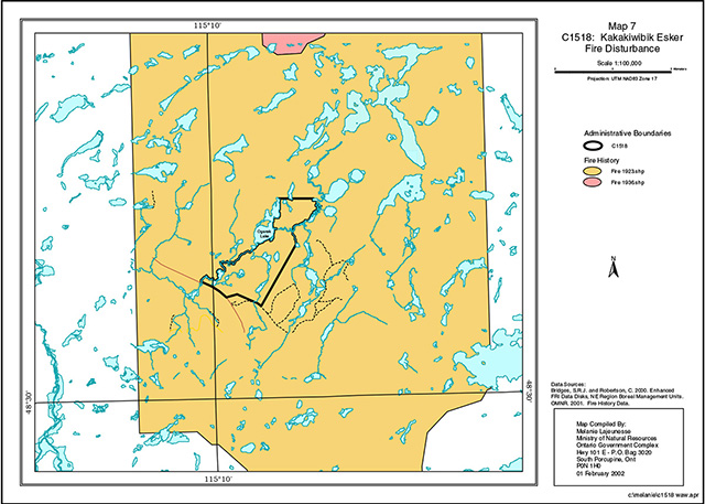
Enlarge Map 7: Kakakiwibik Esker (C1518) - Fire Disturbance
Appendix B
Recreational/Resource Values for Kakakiwibik Esker Conservation Reserve
| Recreational values | Present | Potential |
|---|---|---|
| Private Recreational Camps/ Summer Resort Location | None | None |
| Tourist establishments (outpost camps/ lodges) | None | None |
| Trappers cabins | One Trapcabin is located west of the Kakakwibik Boundary | Possible potential |
| Airport/airstrip | None | None |
| Area of Natural/Scientific Interest (ANSI) | Past Proposed Site found west of the OLL site | No future potential at this time |
| Crown leases | None | None |
| Culture heritage sites | None | None |
| Fisheries values | Oganek Lake (Cool Water), located along west boundary | Potential (recreation fishing) fish species: (Walleye, Pike, White Fish) |
| Fisheries values | North Oganek Lake (Cold Water), located along north boundary | Potential (recreational fishing). Stocked lake fish species (Brook Trout) |
| Fisheries values | North O'Brien Lake (Cold Water), within OLL boundary | Potential (recreational fishing). Stocked lake fish species (Brook Trout) |
| Fisheries values | South O'Brien Lake (Cold Water), within OLL boundary | Potential (recreational fishing). Stocked lake fish species (Brook Trout) |
| Hydrolines passing through site | None | None |
| Research plot | Existing unknown owners | |
| Moose aquatic feeding areas | None | Possible Potential |
| Nesting sites | Known nesting sites | |
| Private land | None | None |
| Roads | Highway 17 existing along part of the south OLL boundary | No future development is planned |
| Roads | Tertiary road existing following along the south OLL boundary outside of the site | At the present time no future development is planned |
| Tower sites | None | None |
| Trails | Existing canoe route along the west side of the OLL Boundary | Present trail usage is unknown |
| Camping areas | Existing | |
| Trapline area | Existing | Active |
| Waste disposal sites | None | None |
| Water lots | None | None |
| Wild rice stands | None | None |
| Work camps | None | None |
| Bear management area | Existing | Active |
| Baitfish areas | None | Active |
| Gravel pits | Existing | Closed & rehabilitated |
Appendix C
Earth Science Inventory Checklist
| Name | Kakakiwibik Esker (C1518) |
|---|---|
| Map Name: | White River |
| NTS Number: | 42C/11 |
| UTM Ref. (Datum): | 637000 E, 5340500 N (NAD 83) |
| Latitude: | 48° 33' |
| Longitude: | 85° 09' |
| Elevation (Min): | 400 m asl |
| Elevation (Max): | 460 m asl |
| Locality: | White River |
| Township: | Abraham, and Vasiloff |
| Area (ha): | 521 |
| Ownership: | Crown |
| MNR Region: | Northeast |
| MNR District: | Wawa |
| Aerial Photographs: | 89-43, 4819, 01 to 03 |
| Prepared by: | F.J. (Rik) Kristjansson, Consulting Geoscientist |
| Reviewed by: | Phil Kor, Senior Conservation Geologist |
Earth science features
Bedrock geology:
Based on relatively recent compilation mapping of the bedrock geology of northeastern Ontario (Ontario Geological Survey, 1991, Map 2543), the Kakakiwibik Esker Conservation Reserve appears to be underlain by undifferentiated, granitic rocks of the Superior Province, Precambrian Shield.
Surficial geology:
Based on a brief reconnaissance helicopter survey, review of available terrain geology mapping (McQuay, 1980, Data Base Map 5094), review of available Quaternary geological mapping (Geddes and Kristjansson, 1986, Map P.2988), and interpretation of relatively recent aerial photography (1989; Appendix A), the area encompassed by the Kakakiwibik Esker Conservation Reserve appears to be immediately underlain by areas of Bedrock-Drift Complex (Unit 2), Ice-Contact Stratified Drift Deposits (Unit 4), Glaciofluvial Outwash Deposits (Unit 5), Alluvial Deposits (Unit 8), and Organic Deposits (Unit 9).
Two areas of Bedrock-Drift Complex (Unit 2) are located in the south half of the conservation reserve. The eastern area of bedrock-drift complex is dominated by an isolated bedrock knob or knoll form. The crest area of the bedrock knob form appears to be characterized by minor to moderate bedrock exposure, whereas the flank areas appear to exhibit a thin, but generally continuous, drift cover (probably till). The western area of bedrock-drift complex may be described as an area of moderate bedrock exposure associated with a thin, discontinuous drift cover.
An extensive area of Ice-Contact Stratified Drift Deposits (Unit 4) dominates the surficial geology of this conservation reserve, and contains the primary features of earth science natural heritage value. Ice-contact stratified drift in the region surrounding the conservation reserve is in general related to a series of relatively narrow belts of ice-contact landforms and sediments oriented approximately parallel to the latest direction of glacier flow and spaced approximately 10 km apart. These belts can be classified on a morphological basis as esker-kame-kettle complexes, all of which "have a well developed central esker ridge, which often grades laterally into a sequence of kettled kame terraces and outwash flats" (Geddes and Kristjansson, 1986). The approximately equidistant spacing of these esker-kame-kettle belts suggests a symmetrical and well-integrated meltwater drainage system. The ice-contact stratified drift deposits encompassed by the conservation reserve are part of a well-developed esker-kame-kettle belt which can be traced from north to south through the east part of the White River map sheet area (NTS Reference 42C/11).
Ice-contact stratified drift deposits, classified morphologically as esker-kame- kettle complex, immediately underlie much of the south half and much of the north half of the Kakakiwibik Esker Conservation Reserve. A generally continuous, somewhat sinuous, relatively sharp-crested esker ridge extends through the conservation reserve from the southeast quadrant to the northwest quadrant and beyond (Photo. C1518-01). This section of esker ridge (approximately 4 to 5 km within the conservation reserve) is part of a much longer esker ridge, which can be traced north northeast from the northwest quadrant into the area immediately north of the conservation reserve.
In the southeast quadrant, various oval to linear, irregular-shaped kettle holes are situated immediately adjacent to the esker ridge (Photo. C1518-01). In the north half of the conservation reserve, relatively large ice block depressions are associated with the esker ridge. For example, the Oganek Lake basin was probably formed through the post-depositional melting of a number of large blocks of stagnant glacier ice. Both the oval to linear, irregular-shaped kettle holes and the relatively large ice block depressions often occur as paired ice- contact depressions. For example, the somewhat rounded, south half of Oganek Lake, which is situated a short distance to the west of the esker ridge, possibly represents a single, large, stagnant ice block depression (Photo. C1518-02). This south half of the lake basin appears to correspond with a similar-sized depression located a short distance to the east of the esker ridge, although most of this eastern depression has been infilled with organic materials (Photo. C1518-03). It should be noted that various ice-contact slopes are associated with these paired ice block depressions. In addition, well- developed kame terraces are present immediately adjacent to both west and east flanks of the esker ridge at this location.
The esker ridge is also associated with a number (at least two within the conservation reserve) of relatively extensive, more or less planar to hummocky (i.e., kamiform), fan-shaped sediment bodies, which are interpreted as the proximal areas of sequential, subaerial outwash fans. The outwash fans are located in the areas east and southeast of the south half of Oganek Lake, and east of the north half of Oganek Lake. The west portion of the later, more northerly fan appears to have bisected Oganek Lake. Referring to the southerly outwash fan, a semi-isolated mound which on its distal side is essentially gradational with the remainder of the fan is believed to represent the apex area of an outwash fan. This particular landform is depicted using an open kame symbol. Although the level of the fan apex is approximately equivalent with the esker crest, the more distal areas of the southerly fan appear to be gradational with the area of glaciofluvial outwash within and west of the southwest quadrant.
The Glaciofluvial Outwash Deposits (Unit 5) which immediately underlie much of both the southwest and northeast quadrants appear to be kettled, although these probable ice-contact depressions might be better referred to as stagnant ice block depressions. These areas of kettled outwash deposits are situated immediately adjacent to the linear area of esker-kame-kettle forms, and are probably gradational with respect to ice-contact characteristics.
Both southwest and northeast areas of glaciofluvial outwash deposits have to some extent been reworked by the Depew River. The Alluvial Deposits (Unit 8) associated with the Depew River in these areas are representative of this post- glacial fluvial activity. The alluvial plain situated within the southwest quadrant is particularly well-developed. At least three, and possibly four, abandoned channels (i.e., "meander loops") were observed within this landform feature.
Finally, as indicated above, both southwest and northeast areas of glaciofluvial outwash deposits are associated with a variety of depressional areas. which probably represent stagnant ice block depressions. These depressional areas contain Organic Deposits (Unit 9) which represent the post-glacial accumulation of organic materials under poorly-drained conditions. The poorly-drained conditions are probably the result of a high water table and its exposure within these depressional areas.
Significance:
It should be noted that the Kakakiwibik Esker Conservation Reserve was originally defined as an Earth Science Site. The primary features of earth science natural heritage value are contained within the extensive area of ice-contact stratified drift deposits which immediately underlie much of the south half and much of the north half of the conservation reserve. The esker ridge represents the subglacial conduit along which meltwater and sediment was transported to the ice margin. Proceeding from south to north, the association of the esker ridge with a succession of paired kettle holes and ice block depressions, as well as with sequential fan-shaped sediment bodies interpreted as the proximal areas of subaerial outwash fans, suggests the incremental meltback of the ice margin through the area of the conservation reserve. Effectively, the primary earth science features encompassed by this conservation reserve represent a record of the style of glacier recession, which occurred in this region at the end of the last glaciation. While these types of landforms and deposits are commonly encountered in other esker-kame-kettle belts in this region, it was considered necessary to achieve some representation of these earth science features. Therefore, considering the exceptional development and interpretability of this particular esker-kame-kettle complex, the Kakakiwibik Esker Conservation Reserve has been accorded regional significance.
Sensitivity:
Considering the relatively passive land uses anticipated within a conservation reserve (e.g., hunting), the various earth science features are considered to have low sensitivity.
Recommendations:
Based on the results of a reconnaissance helicopter survey (Fall 2001), The Kakakiwibik Esker Conservation Reserve, with the exception of a sand and gravel pit situated in the extreme south central part, appears to be in excellent condition. In addition, the areas located immediately west of the southwest quadrant and immediately north of the northeast and northwest quadrants appear to be in excellent condition. If the Ministry of Natural Resources ever considers it desirable to expand the boundaries of this conservation reserve, it is recommended that the indicated areas be included as part of this conservation reserve.
Regionally, as indicated above, the various esker-kame-kettle belts often exhibit "a well developed central esker ridge which often grades laterally into a sequence of kettled kame terraces and outwash flats" (Geddes and Kristjansson, 1986). The area located immediately west of the southwest quadrant is for the most part immediately underlain by relatively continuous glaciofluvial outwash deposits. With the incorporation of this area, a complete gradation including esker ridge, kettled kame terrace, kettled outwash plain, and outwash plain will be present in the conservation reserve.
The area situated immediately north of the northeast and northwest quadrants essentially contains more of the regional esker-kame-kettle belt which can be traced from south to north through the east part of the White River map sheet area (NTS Reference 42 C/11). As indicated above, the esker ridge within the conservation reserve can be traced north northeast from the northwest quadrant into the area immediately north of the conservation reserve. The esker ridge within this area appears to be continuous for at least 3 km after which a small lake is encountered. It is recommended that the area between the present north boundary of the conservation reserve and the small lake be incorporated into the conservation reserve. The area at the time of the reconnaissance helicopter flight appeared to be in excellent condition.
References:
Geddes, R.S. and Kristjansson, F.J., 1986; Quaternary Geology of the White River Area, Districts of Thunder Bay and Algoma; Ontario Geological Survey, Map P.2988, Geological Series - Preliminary Map, Scale 1:50,000. Geology 1983, 1985.
McQuay, D.F., 1980; Northern Ontario Engineering Geology Terrain Study, Data Base Map, White River; Ontario Geological Survey, Map 5094, Scale 1:100,000.
Ontario Geological Survey, 1991; Bedrock Geology of Ontario, East-Central Sheet; Ontario Geological Survey, Map 2543, Scale 1:1,000,000.
Photographs:
Photo. C1518-01: The esker ridge can be traced from the lower left to the upper right of the photograph. The two lakes (central area of photograph), which are situated immediately adjacent to the west and east flanks of the esker ridge, are paired, ice- contact or paired, kettle lakes. The larger water body situated perhaps 400 metres beyond the smaller, ice- contact lakes is Oganek Lake. The view is approximately NNW from the area of the east boundary towards the south half of Oganek Lake.
Photo. C1518-02: Shows the somewhat rounded, south half of Oganek Lake, which is situated a short distance to the west of the esker ridge. It is considered that this south half of the lake basin represents a single, large, stagnant ice block depression. The view is approximately WNW from the area of the east boundary (at Depew Creek) towards Oganek Lake.
Photo. C1518-03: Shows the depressional area (lower left of photograph), almost infilled with organic materials, which corresponds with the south half of Oganek Lake. To reiterate, both kettle holes and ice block depressions often occur as paired ice-contact depressions. Whereas the south half of Oganek Lake is situated a short distance to the west of the esker ridge, the indicated depressional area is situated a short distance to the east of the esker ridge. The view is approximately NNW from the area of the east boundary across the north half of the conservation reserve.
Appendices:
Appendix A: Preliminary Surficial Geology of the Kakakiwibik Esker Conservation Reserve (C1518)