Lakeside Daisy Recovery Strategy
This document is the recovery strategy for Lakeside Daisy, a species of plant at risk in Ontario.
About the Ontario recovery strategy series
This series presents the collection of recovery strategies that are prepared or adopted as advice to the Province of Ontario on the recommended approach to recover species at risk. The Province ensures the preparation of recovery strategies to meet its commitments to recover species at risk under the Endangered Species Act (ESA) and the Accord for the Protection of Species at Risk in Canada.
What is recovery?
Recovery of species at risk is the process by which the decline of an endangered, threatened, or extirpated species is arrested or reversed, and threats are removed or reduced to improve the likelihood of a species' persistence in the wild.
What is a recovery strategy?
Under the ESA a recovery strategy provides the best available scientific knowledge on what is required to achieve recovery of a species. A recovery strategy outlines the habitat needs and the threats to the survival and recovery of the species. It also makes recommendations on the objectives for protection and recovery, the approaches to achieve those objectives, and the area that should be considered in the development of a habitat regulation. Sections 11 to 15 of the ESA outline the required content and timelines for developing recovery strategies published in this series.
Recovery strategies are required to be prepared for endangered and threatened species within one or two years respectively of the species being added to the Species at Risk in Ontario list. There is a transition period of five years (until June 30, 2013) to develop recovery strategies for those species listed as endangered or threatened in the schedules of the ESA. Recovery strategies are required to be prepared for extirpated species only if reintroduction is considered feasible.
What’s next?
Nine months after the completion of a recovery strategy a government response statement will be published which summarizes the actions that the Government of Ontario intends to take in response to the strategy. The implementation of recovery strategies depends on the continued cooperation and actions of government agencies, individuals, communities, land users, and conservationists.
For more information
To learn more about species at risk recovery in Ontario, please visit the Ministry of Natural Resources and Forestry’s Species at Risk webpage
Recommended citation
Ontario Ministry of Natural Resources. 2013. Recovery Strategy for the Lakeside Daisy (Tetraneuris herbacea) in Ontario. Ontario Recovery Strategy Series. Ontario Ministry of Natural Resources, Peterborough, Ontario. iii + 5 pp + Appendix xi + 60 pp. Adoption of the Recovery Strategy for the Lakeside Daisy (Hymenoxys herbacea) in Canada (Parks Canada Agency 2011).
ISBN 978-1-4435-9439-4 (PDF)
Content (excluding the cover illustration) may be used without permission, with appropriate credit to the source.
Cette publication hautement spécialisée Recovery strategies prepared under the Endangered Species Act, 2007, n'est disponible qu'en anglais en vertu du Règlement 411/97 qui en exempte l'application de la Loi sur les services en français. Pour obtenir de l'aide en français, veuillez communiquer avec Cathy Darevic au ministère des Richesses naturelles au 705-755-5580.
Declaration
The recovery strategy for the Lakeside Daisy was developed in accordance with the requirements of the Endangered Species Act, 2007 (ESA). This recovery strategy has been prepared as advice to the Government of Ontario, other responsible jurisdictions and the many different constituencies that may be involved in recovering the species.
The recovery strategy does not necessarily represent the views of all of the individuals who provided advice or contributed to its preparation, or the official positions of the organizations with which the individuals are associated.
The goals, objectives and recovery approaches identified in the strategy are based on the best available knowledge and are subject to revision as new information becomes available. Implementation of this strategy is subject to appropriations, priorities and budgetary constraints of the participating jurisdictions and organizations.
Success in the recovery of this species depends on the commitment and cooperation of many different constituencies that will be involved in implementing the directions set out in this strategy.
Responsible jurisdictions
Ontario Ministry of Natural Resources
Environment Canada – Canadian Wildlife Service, Ontario
Parks Canada Agency
Adoption of recovery strategy
The Endangered Species Act, 2007 (ESA) requires the Minister of Natural Resources to ensure recovery strategies are prepared for all species listed as endangered or threatened on the Species at Risk in Ontario (SARO) List. Under the ESA, a recovery strategy may incorporate all or part of an existing plan that relates to the species.
The Lakeside Daisy (Tetraneuris herbacea) is listed as threatened on the SARO List. The species is also listed as threatened under the federal Species at Risk Act (SARA). Parks Canada Agency prepared the Recovery Strategy for the Lakeside Daisy in Canada in 2011 to meet its requirements under the SARA. This recovery strategy is hereby adopted under the ESA. With the additions indicated below, the enclosed strategy meets all of the content requirements outlined in the ESA.
Species assessment and classification
Common name: Lakeside Daisy:
Scientific name: Tetraneuris herbacea
SARO List Classification: Threatened
SARO List History: Threatened (2004)
COSEWIC Assessment History: Threatened (2002)
SARA Schedule 1: Threatened (January 12, 2005)
Conservation status ranking: GRank: G3, NRank: N3, SRank: S3
The glossary provides definitions for technical terms, including the abbreviations above.
Area for consideration in developing a habitat regulation
Under the ESA, a recovery strategy must include a recommendation to the Minister of Natural Resources on the area that should be considered in developing a habitat regulation. A habitat regulation is a legal instrument that prescribes an area that will be protected as the habitat of the species. The recommendation provided below will be one of many sources considered by the Minister when developing the habitat regulation for this species.
Section 2.4 of the federal recovery strategy provides an identification of critical habitat (as defined under the SARA). Identification of critical habitat is not a component of a recovery strategy prepared under the ESA. However, it is recommended that the approach used to identify critical habitat in Section 2.4 be considered when developing a habitat regulation under the ESA.
Glossary
Committee on the Status of Endangered Wildlife in Canada (COSEWIC): The committee established under section 14 of the Species at Risk Act that is responsible for assessing and classifying species at risk in Canada.
Committee on the Status of Species at Risk in Ontario (COSSARO): The committee established under section 3 of the Endangered Species Act, 2007 that is responsible for assessing and classifying species at risk in Ontario.
Conservation status rank: A rank assigned to a species or ecological community that primarily conveys the degree of rarity of the species or community at the global (G), national (N) or subnational (S) level. These ranks, termed G-rank, N-rank and S-rank, are not legal designations. The conservation status of a species or ecosystem is designated by a number from 1 to 5, preceded by the letter G, N or S reflecting the appropriate geographic scale of the assessment. The numbers mean the following:
1 = critically imperilled
2 = imperilled
3 = vulnerable
4 = apparently secure
5 = secure
Endangered Species Act, 2007 (ESA): The provincial legislation that provides protection to species at risk in Ontario.
Species at Risk Act (SARA): The federal legislation that provides protection to species at risk in Canada. This act establishes Schedule 1 as the legal list of wildlife species at risk. Schedules 2 and 3 contain lists of species that at the time the Act came into force needed to be reassessed. After species on Schedule 2 and 3 are reassessed and found to be at risk, they undergo the SARA listing process to be included in Schedule 1.
Species at Risk in Ontario (SARO) List: The regulation made under section 7 of the Endangered Species Act, 2007 that provides the official status classification of species at risk in Ontario. This list was first published in 2004 as a policy and became a regulation in 2008.
Appendix 1 - Recovery strategy for the Lakeside Daisy (Hymenoxys herbacea) in Canada
Lakeside Daisy
2011
About the Species at Risk Act recovery strategy series
What is the Species at Risk Act (SARA)?
SARA is the Act developed by the federal government as a key contribution to the common national effort to protect and conserve species at risk in Canada. SARA came into force in 2003, and one of its purposes is "to provide for the recovery of wildlife species that are Extirpated, Endangered or Threatened as a result of human activity."
What is recovery?
In the context of species at risk conservation, recovery is the process by which the decline of an endangered, threatened or extirpated species is arrested or reversed and threats are removed or reduced to improve the likelihood of the species' persistence in the wild. A species will be considered recovered when its long-term persistence in the wild has been secured.
What is a recovery strategy?
A recovery strategy is a planning document that identifies what needs to be done to arrest or reverse the decline of a species. It sets goals and objectives and identifies the main areas of activities to be undertaken. Detailed planning is done at the action plan stage.
Recovery strategy development is a commitment of all provinces and territories and of three federal agencies — Environment Canada, Parks Canada Agency, and Fisheries and Oceans Canada — under the Accord for the Protection of Species at Risk. Sections 37–46 of SARA (http://www.sararegistry.gc.ca/approach/act/default_e.cfm) [Link no longer active] outline both the required content and the process for developing recovery strategies published in this series.
Depending on the status of the species and when it was assessed, a recovery strategy has to be developed within one to two years after the species is added to the List of Wildlife Species at Risk. Three to four years is allowed for those species that were automatically listed when SARA came into force.
What’s next?
In most cases, one or more action plans will be developed to define and guide implementation of the recovery strategy. Nevertheless, directions set in the recovery strategy are sufficient to begin involving communities, land users, and conservationists in recovery implementation. Cost-effective measures to prevent the reduction or loss of the species should not be postponed for lack of full scientific certainty.
The series
This series presents the recovery strategies prepared or adopted by the federal government under SARA. New documents will be added regularly as species get listed and as strategies are updated.
To learn more
To learn more about the Species at Risk Act and recovery initiatives, please consult the SARA Public Registry.
Recovery Strategy for the Lakeside Daisy (Hymenoxys herbacea) in Canada
Recommended citation:
Parks Canada Agency. 2011. Recovery Strategy for the Lakeside Daisy (Hymenoxys herbacea) in Canada. Species at Risk Act Recovery Strategy Series. Parks Canada Agency, Ottawa. xi + 60 pp.
Additional copies:
Additional copies can be downloaded from the SARA Public Registry.
Également disponible en français sous le titre « Programme de rétablissement de l'hyménoxys herbacé (Hymenoxys herbacea) au Canada »
© Her Majesty the Queen in Right of Canada, represented by the Minister of theEnvironment, 2008. All rights reserved.
ISBN 978-1-100-17324-5
Catalogue no. En3-4/86-2011E-PDF
Content (excluding the illustrations) may be used without permission, with appropriate credit to the source.
Recommendation and approval statement
The Parks Canada Agency led the development of this federal recovery strategy, working together with the other competent minister(s) for this species under the Species at Risk Act. The Chief Executive Officer, upon recommendation of the relevant Park Superintendent(s) and Field Unit Superintendent(s), hereby approves this document indicating that Species at Risk Act requirements related to recovery strategy development (sections 37-42) have been fulfilled in accordance with the Act.
Recovery Strategy for Lakeside Daisy (Hymenoxys herbacea) in Canada
Recommended and signed by:
Frank Burrows
Superintendent, Bruce Peninsula National Park and Fathom Five National Marine Park
Approved and signed by:
Kim St. Claire
Field Unit Superintendent, Georgian Bay
Approved and signed by:
Alan Latourelle
Chief Executive Officer, Parks Canada
All competent ministers have approved posting of this recovery strategy on the Species at Risk Public Registry.
Declaration
Under the Accord for the Protection of Species at Risk (1996), the federal, provincial, and territorial governments agreed to work together on legislation, programs, and policies to protect wildlife species at risk throughout Canada. The Species at Risk Act (S.C. 2002, c.29) (SARA) requires that the federal competent ministers prepare recovery strategies for listed Extirpated, Endangered and Threatened species.
The Minister of the Environment presents this document as the recovery strategy for Lakeside Daisy, as required under SARA. It has been prepared in cooperation with the jurisdictions responsible for the species, as described in the Preface. The Minister invites other jurisdictions and organizations that may be involved in recovering the species to use this recovery strategy as advice to guide their actions.
The goals, objectives, and recovery approaches identified in the strategy are based on the best existing knowledge and are subject to modifications resulting from new findings and revised objectives.
This recovery strategy will be the basis for one or more action plans that will provide further details regarding measures to be taken to support protection and recovery of the species. Success in the recovery of this species depends on the commitment and cooperation of many different constituencies that will be involved in implementing the actions identified in this strategy. In the spirit of the Accord for the Protection of Species at Risk, all Canadians are invited to join in supporting and implementing this strategy for the benefit of the species and of Canadian society as a whole. The Minister of the Environment will report on progress within five years.
Acknowledgments
Parks Canada Agency led the development of the recovery strategy. The strategy was prepared by J.A. Jones and J.V. Jalava for the Bruce Peninsula and Manitoulin Island Alvar
Strategic environmental assessment statement
A strategic environmental assessment (SEA) is conducted on all SARA recovery strategies, in accordance with the Cabinet Directive on the Environmental Assessment of Policy, Plan and Program Proposals. Recovery planning is intended to benefit species at risk and biodiversity in general. However, it is recognized that strategies and action plans may also inadvertently lead to environmental effects beyond the intended benefits. The results of the SEA are summarized below and briefly outline the potential positive and negative environmental impacts as a result of the proposed recovery strategy, and resultant mitigation.
Most threats to Lakeside Daisy (Hymenoxys herbacea) are threats to its alvar habitat. Thus, the steps proposed in this recovery strategy are intended to positively impact the alvar ecosystem as a whole and to benefit the other species that occupy the habitat as well as. First and foremost, the broad strategy in this document is to protect remaining high quality examples of alvar. Much good alvar still exists in the Bruce Peninsula and Manitoulin Regions, so rehabilitation of degraded sites is of lower priority. Therefore, recoveryactivities for the most part will be fairly non-intrusive, allowing natural ecological processes to carry on. Future actions proposed in this recovery strategy involve communication and education, protection, management and stewardship, policy and legislation, inventory and monitoring, and research.
Specific examples of positive effects include:
- Protection of lands containing alvar habitat will benefit all species occupying these areas, as well as provide a benefit to species that use alvars for only part of their life cycle (e.g. for pollination, nesting, hibernacula).
- Application of strategies and knowledge developed for this recovery strategy will also aid in recovery efforts for six other COSEWIC listed species that occupy alvar ecosystems of the Bruce Peninsula and Manitoulin Regions. These include: Gattinger’s Agalinis, Houghton’s Goldenrod, Hill’s Thistle, Dwarf Lake Iris, Massasauga Rattlesnake, and Tuberous Indian Plantain.
- Signs posted and barriers constructed to reduce trampling and overuse will have apositive effect by reducing damage to the entire alvar habitat and surrounding vegetation.
- Identification and mapping of globally and provincially significant alvars may result in a better understanding of species distribution and habitat requirements which will contribute to more effective protection.
- Training of park wardens and conservation officers in field identification will enhance conservation of alvars and will therefore afford protection to other species occupying this habitat, including both Species at Risk (SAR) and non SAR.
- Increasing public understanding of the significance of alvars will benefit all alvar species, including Lakeside Daisy.
- Consideration of alvars during land use planning should help deflect impacts from these ecosystems and the species that live there.
The proposed activities have almost no potential for negative environmental impacts other than the possibility of a small amount of trampling from foot traffic during research and monitoring. Researchers carrying out field studies in alvar habitat need to be cautioned on the potential problem and instructed how to prevent creating such impacts.
It is not anticipated that fire will be used as a management tool in the habitat of Lakeside Daisy in the foreseeable future. Most steps in this strategy deal with engaging the public and with protecting existing high quality occurrences rather than with restoring degraded areas.It is known that some alvars have burned, but there has been almost no recent burning (in the last 50 years). Therefore, the use of burning is not a priority for management. If research on fire as a management tool is undertaken, a separate environmental assessment would need to be done.
Placement of barriers such as boulders or gates may have a small amount of impact depending on the kinds of construction techniques used. Use of heavy machinery to place boulders as barriers can be done from existing trails during dry conditions to minimize soil displacement. It is expected that signage, gates, and fencing would be placed outside the habitat in transitional areas that are less sensitive to disturbance. For example, signage to alert visitors to the sensitivity of an area and to keep hikers on trails would be located before entering the habitat, in places where there is enough soil to anchor signage in the ground or on bedrock or other ground that is already disturbed. Barriers and signage will not be placed in high quality alvar habitat.
Preface
This recovery strategy addresses the recovery of Lakeside Daisy. In Canada, this species is only found in the Bruce Peninsula and Manitoulin Island Region of Ontario.
The Parks Canada Agency and the Ontario Ministry of Natural Resources cooperatively led the development of this recovery strategy, with the members of the Bruce Peninsula and Manitoulin Island Alvar Recovery Team, and in cooperation and consultation with the Canadian Wildlife Service - Ontario Region, stakeholders, and private landowners. All responsible jurisdictions reviewed and supported posting of the strategy. The proposed recovery strategy meets SARA requirements in terms of content and process (Sections 39-41) and fulfills commitments of all jurisdictions for recovery planning under the Accord for the Protection of Species at Risk in Canada.
Residence
SARA defines residence as: a dwelling-place, such as a den, nest or other similar area or place, that is occupied or habitually occupied by one or more individuals during all or part of their life cycles, including breeding, rearing, staging, wintering, feeding or hibernating [Subsection 2(1)]. The concept of residence under the Species at Risk Act (SARA) does not apply to this species. Residence descriptions, or the rationale for why the residence concept does not apply to a given species, are posted on the SARA public registry: http://www.sararegistry.gc.ca/plans/residence_e.cfm [Link no longer active.]
Executive summary
Lakeside Daisy is listed as Threatened under Schedule 1 of the federal Species at Risk Act (SARA). In Ontario, it is listed as Threatened on the Species at Risk in Ontario (SARO) List under the Endangered Species Act, 2007 (ESA). The global range of Lakeside Daisy is restricted to the Bruce Peninsula and Manitoulin Island Regions of Ontario and six sites inthe United States, some of which are re-introductions. The Canadian range of Lakeside Daisy accounts for 95% or more of the global population.
Lakeside Daisy is a low-growing herbaceous perennial consisting of small, leafy rosettes connected by rhizomes. Plants bloom in early May to early July with a yellow daisy-like head on a short stalk. Lakeside Daisy is only found on alvars and limestone bedrock shorelines. Alvars are naturally open areas, dominated by native grasses or sedges or low shrubs, with extremely shallow soil over limestone bedrock. They experience extremes ofdrought, flooding, temperature, and light levels. Some alvars that support Lakeside Daisy are known to have burned in the past, but others have no evidence of burning at all. The alvarsof the Bruce Peninsula and Manitoulin Island Regions contain an exceptional variety of globally and provincially rare vegetation types and species. All alvars in Ontario are considered globally, nationally and provincially imperiled.
The main threats to Lakeside Daisy are threats to its alvar habitat. The principal threats are: off-road vehicles, building and road construction, trampling by pedestrians, quarrying, logging in adjacent forests, invasion by exotic species, and heavy machinery. As well, filling in of habitat due to fire suppression, and changes in lake levels, may affect habitat over very long time frames. Severity of threats is presented for each site.
Lakeside Daisy is found at nine sites on the Bruce Peninsula and 20 sites on the south shore of Manitoulin Island or surrounding islands. At some of the sites where it occurs, Lakeside Daisy can be abundant or even dominant. Current population trends are unknown due to lack of monitoring information.
Recovery is considered feasible for Lakeside Daisy. The goal is to maintain long-term, self-sustaining, viable populations of Lakeside Daisy in its current range in Ontario, by meeting population and distribution objectives targeted to recover the species to Special Concern or lower. The population and distribution objectives for Lakeside Daisy are 1) Prevent an overall, continuous decline in the number of populations in each of the two core areas the species occupies, and 2) Maintain the species' range at its current index of area of occupancy (114 km2) and current extent of occurrence (2,340 km2).
In total, 12 critical habitat polygons are identified at 9 sites on the Bruce Peninsula and 46 polygons are identified at 9 sites in the Manitoulin Region. This critical habitat achieves substantive progress toward fulfilling the population and distribution objectives identified in the strategy. Other recovery tools will be used to meet the objectives, and these will be achieved through implementation of the broad strategies and approaches - - primarily protection of existing populations, reduction of threats to habitat, promoting site stewardship, and public education. One or more action plans will be completed by December 2015.
Recovery feasibility summary
Recovery of Lakeside Daisy in Canada is considered feasible based on the criteria outlined by the Government of Canada (2009):
- Individuals of the wildlife species that are capable of reproduction are available now or in the foreseeable future to sustain the population or improve its abundance.
Yes; biologically, this species has many large, self-sustaining populations and sites where abundant or even dense growth of plants is present. There are sufficient numbers to improve population sizes when adequate habitat is present and threats are not present. Biological factors are probably not the main limitations for this species. - Sufficient suitable habitat is available to support the species or could be made available through habitat management or restoration.
Yes; the habitat of Lakeside Daisy has been shown to change very slowly over long periods of time (50-200 years). Large areas of high quality, intact alvar habitat still exist, with several now in protected areas. - The primary threats to the species or its habitat (including threats outside Canada)can be avoided or mitigated.
Yes; many threats can be avoided or mitigated through communications actions to increase awareness about the species, liaising with other groups and agencies, erecting signage, working with management of protected areas, and many other steps. - Recovery techniques exist to achieve the population and distribution objectives or can be expected to be developed within a reasonable timeframe.
Yes; the Nature Conservancy’s International Alvar Initiative (IACI) (Reschke et al. 1999)initiated recovery of alvar ecosystems and associated rare species, and experiences from the IACI show these techniques can be very effective.
1.0 Background
1.1 COSEWIC species assessment information
Date of Assessment: May 2002
Scientific Name: Hymenoxys herbacea (E.L. Greene) Cusick
COSEWIC Status: Threatened
Canadian Occurrence: Ontario
Reason for Designation: A Great Lakes endemic of global importance, geographically restricted to two shoreline regions of very restricted and provincially rare alvar habitats with large populations subject to risks from natural herbivores and increasing recreational use of its habitat.
COSEWIC Status History: Designated Threatened in May 2002. Assessment based on a new status report.
1.2 Species status information
Lakeside Daisy is listed as Threatened and is on Schedule 1 of the federal Species at Risk Act (SARA). In Ontario it is listed as Threatened on the Species at Risk in Ontario (SARO) List under the Endangered Species Act, 2007 (ESA). The global rank of Lakeside Daisy is G3 or Vulnerable (Nature Serve 2009). It is currently listed as S1 or Critically Imperiled in Illinois, Michigan, and Ohio, and S3 or Vulnerable in Ontario. The species is federally listed as Threatened in the United States. The global range of Lakeside Daisy is completely restricted to the Bruce Peninsula and Manitoulin Island Regions of Ontario and six sites in the United States, some of which are re-introductions (Nature Serve 2009). The Canadian range of Lakeside Daisy probably accounts for 95% or more of the global population. See Section 2.1 Populations and Distribution Context.
1.3 Description of the species and its needs
1.3.1 Species description
Also called "Stemless Rubberweed" on the Bruce Peninsula or "Manitoulin Gold" on Manitoulin Island (Morton and Venn 2000), the name Lakeside Daisy is derived from its occurrence at Lakeside, Ohio. The plant is a low-growing herbaceous perennial consisting of several small, leafy rosettes connected by rhizomes. The leaves are dark green and faintly hairy. Floral buds form in the fall and rosettes persist through the winter, allowing the plant to bloom in early spring, starting in early May and continuing in some areas to early July (COSEWIC 2002). The inflorescence is a yellow daisy-like head on a short stalk (5-15 cm)that elongates somewhat during fruit set and dispersal.
Lakeside Daisy could be confused with Lance-leaved Tickseed (Coreopsis lanceolata), a similar yellow-orange, daisy-like flower found on some alvars. However, Lakeside Daisy has faintly hairy (vs. smooth, somewhat shiny) leaves, a short, sturdy (vs. tall, slender) stalk, and yellow (vs. yellow-orange) ray flowers. Also, Lakeside Daisy tends to bloom earlier (early May to early July vs. mid-June to mid-July) and is entirely restricted to alvars on dolostone, whereas Lance-leaved Tickseed also occurs in other open habitats.
1.3.2 Habitat needs of Lakeside Daisy
Lakeside Daisy is only found on alvars and on limestone bedrock shorelines similar to alvars. The alvars of the Bruce Peninsula and Manitoulin Island Regions in Ontario are internationally recognized for their rarity, their distinct ecological character, and for their exceptional variety of globally and provincially rare vegetation types and species. Many of these species are endemic, occurring only in the Great Lakes basin, and some only occur on alvars. A list of rare alvar species is given in Appendix A. All alvars are consideredglobally, nationally and provincially threatened (Nature Serve 2009; NHIC 2009). Because most threats to Lakeside Daisy stem from impacts to its highly threatened alvar habitat, and because of the hugely significant biodiversity on alvars, recovery of Lakeside Daisy will be most effective if undertaken within an ecosystem-based approach.
Alvars are unusual for a number of reasons. They are naturally open areas in an overall forested landscape. The dominant plants are usually native grasses, sedges or low shrubs. Alvars have extremely shallow soil and experience extremes of drought and flooding, temperature, and light levels (Reschke et al. 1999). Some alvars are relict habitats that have existed since the post-glacial era, while others originated from fires, either a catastrophic event, or periodic smaller fires (Jones and Reschke 2005). Alvars contain many species that normally live in other regions such as boreal and prairie biomes (Catling 1995; Catling and Brownell 1993). As well, some alvars support ancient, stunted trees more than 400 years old (Schaefer and Larson 1997).
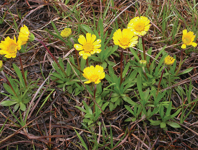
Lakeside Daisy grows on alvars and limestone shores, in shallow cracks or crevices in open, exposed bedrock in a few centimetres of sand or accumulated organic soil, or sometimes in small patches of sand on top of bedrock (Figure 1). It occurs only on Silurian dolostone. Sites are generally dominated by Little Bluestem (Schizachyrium scoparium), Northern Dropseed (Sporobolus heterolepis), Creeping Juniper (Juniperus horizontalis), or by Lakeside Daisy itself. There are few populations in dense grasslands (where there is no bare bedrock) or in treed areas. In the Manitoulin Region, all but 3 of the 20 occurrences are within 500 m of the Lake Huron shore. On the Bruce Peninsula, 4 of the 9 occurrences are inland and therefore at higher elevations.
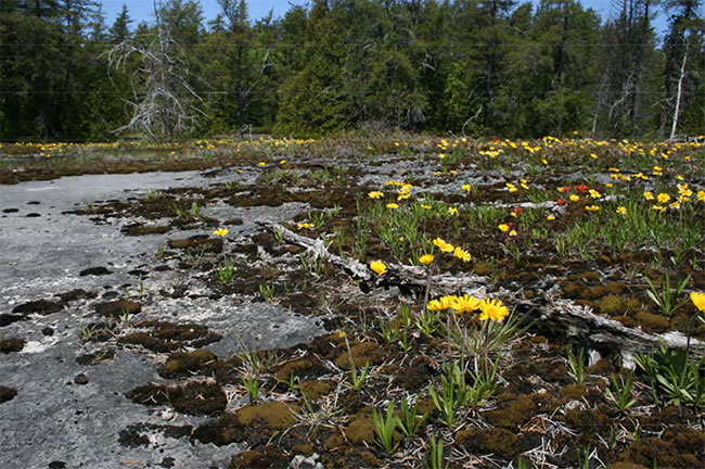
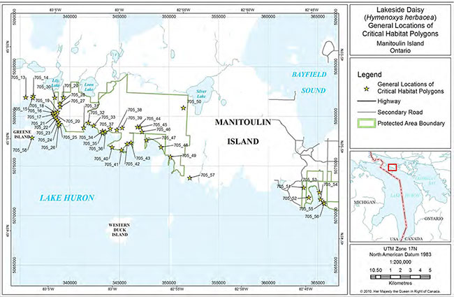
Figure 1: Alvar at Ontario Nature’s Bruce Alvar Nature Reserve with Lakeside Daisy in the Foreground
A number of ecological processes define alvars and possibly maintain them in their open state, and any of these may be a requirement in the habitat of Lakeside Daisy. Alvars typically have very shallow soils (usually 0 to about 20 cm) that provide little water-holding capacity and dry out quickly. The bedrock below permits little drainage after rainfall, causing frequent and rapid flooding. As a result, alvars fluctuate between conditions offlooding and extreme drought. Also, the lack of tree cover and exposed bedrock contribute to high levels of light and wind, as well as temperature extremes, with surface temperatures reaching as high as 53°C in summer (Schaefer and Larson 1997). Hence, most alvar species are assumed to be drought-adapted. Compared to some types of alvar, the habitat of Lakeside Daisy generally has a lot of exposed rock surface and shallower soil layers, making theeffects of natural ecological processes most pronounced. Even in winter under snow, the blackish surface of the bedrock absorbs heat from sunlight and radiates enough warmth to slowly melt snow.
It is not clear whether Lakeside Daisy directly requires fire, but the openness of the habitat where it occurs may be the result of past fire. Some alvars that support Lakeside Daisy are known to have burned in the past, but others have no burn evidence at all (Jones and Reschke 2005). It has been speculated that alvars in the no-burn category originated in post-glacial times and are becoming vegetated at an extremely slow rate (in the order of centuries) (Jones and Reschke 2005), or that the drought-flood cycle and shallow soils perpetually inhibit growth of woody vegetation.
1.3.3 Biological needs of Lakeside Daisy
Flowers of Lakeside Daisy cannot self-pollinate and require insect pollination. Campbell (2001) studied 13 populations of Lakeside Daisy on the Bruce Peninsula and observed that the flowers were visited by at least 41 different taxa of insects from eight different families, although probably not all of them accomplished pollination. The most prevalent visitors were flies; however, additional researchers (DeMauro 1993, Bouchard pers. comm. 1996) suggest that bees are more important pollinators.
Seeds are dispersed by gravity or wind. There is no period of seed dormancy, and new seedlings may appear in late summer (COSEWIC 2002). The species also reproduces vegetatively by rhizomatous growth or branching of the woody caudex. The prevalence of sexual or vegetative reproduction varies from year to year. Campbell (2001) found that 23% of plants reproduced asexually, while 12-24% of plants reproduced sexually during a one year period. In addition, not all fertilized ovaries set fruit—only an average of 42.6% of seeds per inflorescence was produced. Campbell notes as well that in spite of these results, the plants do not appear to suffer pollen limitation. The reason for the low seed set is unknown.
1.4 Threat identification
1.4.1 Threats classification
The main threats to Lakeside Daisy are threats to the alvar ecosystems that are its habitat. Threats were not examined in detail in the COSEWIC Status Report (COSEWIC 2002). Based on more recent background information (NHIC 2009, Jalava 2008, Jalava 2004a, Oldham and Kraus 2002, Brownell and Riley 2000), as well as the direct observations of the authors and recovery team members, the principal anthropogenic stresses affecting Lakeside Daisy and alvar habitats are: off-road vehicle use, building and road construction, trampling by pedestrians, quarrying, logging in adjacent forests, invasion by exotic species, and heavy machinery. Herbivory is noted as an impact to the species in the COSEWIC report (2002), but recent field studies have not corroborated this. As well, genetic isolation is a potential but unstudied threat, and filling in of habitat due to fire suppression, changes in lake levels, and changes in climate, may potentially be affecting habitat over very long time frames.Threats are presented on a site-by-site basis in Table 1. Only those threats that are current and have a high degree of causal certainty and level of concern are presented. Potential and future threats are described in the text below.
1.4.2 Description of threats
Off-road Vehicles Alvars, with their open aspect, are appealing to off-road vehicles, and their use is a serious concern, especially as all-terrain vehicles (ATVs) are nearly unrestricted in their movements and do not require trails or roads. ATVs disturb or destroy vegetation, displace shallow layers of soil, leave ruts, and are vectors for invasive species. ATV use is an increasingly popular recreational pastime, and the threat is widespread. Damage to habitat and uprooting of plants by ATVs on the extremely sensitive alvar pavement (i.e., areas ofbare dolostone bedrock) is a serious, widespread threat to Lakeside Daisy populations, especially where populations are adjacent to shoreline areas that are public rights-of-way.
Table 1. Threats to Lakeside Daisy by Site. Legend: X – Current major impact; x – Current minor impact; H – Historical impact. Threats sources: Brownell and Riley (2000); NHIC (2009); COSEWIC (2002); McGuire (2006); and direct observations by the authors or Recovery Team members.
Bruce Peninsula
| Site Name | Off-road vehicles | Bldg. & road development | Pedestrian trampling | Quarrying | Adjacent logging | Exotic Species | Heavy Machinery |
|---|---|---|---|---|---|---|---|
| Cabot Head PNR | x | x | H | x | |||
| Dyer’s Bay Rd (incl Bruce Alvar NR) |
x | ||||||
| Emmett Lake Road | X | x | x | H | x | ||
| South of George Lake | |||||||
| George Lake | X | x | |||||
| Halfway Log Dump / Cave Point | x | X | |||||
| West of Cave Point | X | ||||||
| Grotto / Overhanging Rock Point | X | ||||||
| East of Nawash HuntingGrounds | x | x |
Manitoulin region
| Site Name | Off-road vehicles | Bldg. & road development | Pedestrian trampling | Quarrying | Adjacent logging | Exotic Species | Heavy Machinery |
|---|---|---|---|---|---|---|---|
| Belanger Bay | X | H | |||||
| Black Point – Fisher Bay | |||||||
| Burnt Island Harbour, NW of Burnt Island Harbour, Christina Bay |
X | ||||||
| Burnt Island Road | |||||||
| Carroll Wood Bay | X | x | |||||
| Gatacre Point (E. Taskerville) | |||||||
| Greene Island | |||||||
| Lorne Lake (Taskerville inland) | |||||||
| Lynn Bay | |||||||
| West of Lynn Point | X | x | x | ||||
| Misery Bay E. | X | H | x | ||||
| Misery Bay W. | x | x | x | H | x | ||
| Mississagi Lighthouse | X | X | x | ||||
| Murphy Point (Macs Bay) | x | H | x | ||||
| Quarry Bay | X | H | x | ||||
| Rickley Harbour/Girouard Pt. | |||||||
| West of Sand Bay | |||||||
| Silver Lake S. of Hwy 540 | x | ||||||
| Silverwater Radio Towers | |||||||
| Taskerville – Portage Point |
xCurrent minor impact
XCurrent major impact
HHistorical impact
Building and road construction
Alvars are prime sites for seasonal or permanent residential development because of their proximity to the Lake Huron shoreline. Alvar habitat may be entirely eliminated by the construction of buildings, yards, driveways, and roads. Associated impacts include: clearing of alvar vegetation; blasting of bedrock for basements, trucking-in of fill that may introduce invasive, non-native plants; trampling of vegetation; and displacement of shallow soils (leaving ruts) by heavy machinery. Several remote sites for Lakeside Daisy have no current impacts (hence they are not represented in the Table above), but could be subdivided and developed in the future.
Trampling by pedestrians
High visitor use and the resulting foot traffic at some alvars threatens the vegetation and sensitive species. In addition, unmonitored camping activities (putting tents, fire pits, and latrines on alvar) threaten some sites. On the Bruce Peninsula, recreational foot traffic is a threat to Lakeside Daisy shoreline occurrences (COSEWIC 2002). Signage, designated trails and boardwalks (at Ontario Nature’s Bruce Alvar Nature Reserve), and relative inaccessibility (Cabot Head and Emmet Lake sites) currently reduce the threat of serious impacts at some locations.
Quarrying
Alvars are prime sites for quarry development because the limestone or dolostone bedrock is close to the surface and little clearing of forest and overlying soil is necessary. Aggregate extraction can completely destroy Lakeside Daisy habitat. On western Manitoulin Island a large area of alvar will be affected by expansion of the largest quarry in Ontario. At present, no significant alvar sites on the Bruce Peninsula are believed to be threatened by quarrying.
Logging
Use of heavy machinery for logging in forests adjacent to alvars and Lakeside Daisy habitat is a frequent and widespread threat. Logging damages alvar habitats when roads are built across alvars or when alvars are used as log landings and loading grounds. This has occurred at several alvars on western Manitoulin Island and could occur again in almost any alvar on private land.
Invasion by exotic species
Invasion by non-native species is one of the most serious effects of human disturbance at alvar sites. Exotic species compete with native species for rooting space and for scarce nutrients and moisture, frequently leading to reduction or extirpation of native species (Stephenson 1995; Jones 2000). Invasion by exotic species is often associated with other human-caused disturbances such as road building. Some examples of problem exotics include Common St. John’s Wort (Hypericum perforatum), Mossy Stonecrop (Sedum acre), Canada Bluegrass (Poa compressa), and White Sweet Clover (Melilotus alba) (Reschke et al. 1999).
Heavy machinery
Use of heavy machinery to remove boulders, stones, and granitic erratics for sale to the landscaping industry also destroys vegetation and displaces shallow soils. The boulders, stones, and erratics themselves have functions within the ecosystem that have not been studied. They may be important in providing small patches of shade, trapping organic matter, supporting numerous lichen species, blocking the wind, or performing other possible functions. Ornamental stone removal has become more common on the Bruce Peninsula recently.
Other potential threats
Filling in of habitat due to fire suppression
It is evident that wildfire occurred during the past 150 years at many alvars in the Bruce and Manitoulin Regions (Schaefer 1996, Schaefer and Larson 1997, Jones and Reschke 2005), and some habitat for Lakeside Daisy was probably created by fire (Jones and Reschke 2005). Filling in of habitat, possibly from fire suppression, may result in the reduction or elimination of Lakeside Daisy habitat over the long term and thus is a threat to the species. However, because the time frame over which this happens is long, and because Lakeside Daisy sites are at different stages of succession, it is difficult to gauge the effects or urgency of this potential threat. The time frame over which this threat may act, and thus the urgency of addressing it, is unknown.
Changes in lake levels
Changes in lake levels affect shoreline populations of Lakeside Daisy. Flooding, wave-wash, and ice-scour may play a role in the perpetuation of the bedrock shoreline habitat of Lakeside Daisy, but at higher lake levels the size or presence of some of these habitats and populations becomes reduced. It is assumed that historically, the species was able to respond to and recover from changes in the natural cycle of lake levels. However, with human controlled out-flow rates (Derecki 1985) and potential diversion of water from Lakes Huron and Michigan, it is not certain that the natural lake level cycles will continue, and this may be a potential threat.
1.5 Actions already completed or underway
In order to plan recovery of Lakeside Daisy, it is important to see the work that has already been done to avoid duplication of efforts. Much work to protect alvars and increase awareness of their significance pre-dated this recovery strategy. Many of these actions have directly protected or otherwise benefited Lakeside Daisy populations. Some of the major accomplishments include:
Bruce Peninsula and Manitoulin Region Alvar Surveys (2004-2008)
A number of previously unsurveyed alvar sites in the Bruce Peninsula (Jalava 2004a, 2006, 2007, 2008) and Manitoulin Regions (Jones 2004-2008) were inventoried and mapped during 2004-2008 to support this recovery strategy and work towards identification of critical habitat for Lakeside Daisy.
First Nations Species at Risk (SAR) inventory and mapping
During the summers of 2007-2009, two First Nations in the Bruce Peninsula and Manitoulin Region undertook inventories (e.g. Jones 2007) that included alvars and Lakeside Daisy. This is the first step towards recognizing the presence and needs of these species on First Nations lands. International Alvar Conservation Initiative (IACI) The IACI, coordinated by The Nature Conservancy, Chicago, IL, studied alvars across North America (Reschke et al. 1999) and produced detailed field inventories and mapping of Lakeside Daisy occurrences. The IACI culminated with a workshop on North American alvars held in June 1998, involving approximately 100 participants. The IACI led to many subsequent alvar conservation activities in Ontario (some described next).
The Ontario Alvar theme study
An ecological theme study of Ontario alvars (Brownell and Riley 2000) was produced by Ontario Nature. This project looked at alvars in Ontario, collected additional field data, ranked sites, and made recommendations on the significance and conservation status of alvars across the province. Lakeside Daisy was used as one of the elements on which the ranking was based.
Alvar stewardship packages
As part of the IACI, stewardship information packages were distributed to private landowners of alvars in the Manitoulin Region (Jones 1998) as well as in other parts of Ontario (Jalava 1998).
Public awareness and consultation
A considerable amount of public contact and education about alvars has already occurred, mostly due to the IACI. Contact was made with many alvar landowners when permission was sought to survey their lands for the IACI. This was followed up with stewardship packages given to many of these landowners. The word "alvar" has become a familiar term in common usage in the Bruce Peninsula and Manitoulin Region. The aggregate industry has been informed about alvars, and the Aggregate Producers Association of Ontario has featured alvars in their annual reports several times (Ontario Aggregate Resources Corporation 2009). These efforts have resulted in increased awareness of Lakeside Daisy.
Protected areas management
At Bruce Peninsula National Park, Misery Bay Provincial Nature Reserve, and private nature reserves such as the Bruce Alvar Nature Reserve, management has focused on maintaining the integrity of Lakeside Daisy habitat and Lakeside Daisy populations. This has resulted in routing trails away from sensitive areas and construction of boardwalks.
Lands protected
Several key alvars have been protected in the last 10 years either by being acquired by private land trusts or incorporated into provincial or national parks, or other protected areas. At present, 18 of 29 Lakeside Daisy sites are found wholly or in part within protected areas (see Section 2.5).
1.6 Knowledge gaps
This section summarizes important knowledge gaps for Lakeside Daisy and alvar ecosystems in the Bruce and Manitoulin Regions.
Land use and threats analysis:
A comprehensive look at current threats and current and proposed land uses in and adjacent to Lakeside Daisy sites is needed to assess likely impacts and help focus conservation and site stewardship activities.
Information on alvar ecology to inform better management of Lakeside Daisy habitat:
Although some recent studies of the natural processes that create and maintain alvars have been undertaken (e.g., Gilman 1995, Schaefer and Larson 1997, Catling and Brownell 1998, Jones and Reschke 2005), many unanswered questions remain. The ecological role of wildfire, flooding, drought, and other factors need to be better understood if long term management and stewardship of alvars are to be successful.
The need for fire:
The use of controlled burning to maintain habitat needs to be studied.
Monitoring change:
How are alvars changing due to threats, or due to natural succession, and how quickly?
Exotic and invasive species:
An understanding of the status, impacts, and control of exotic and invasive species in alvars would be useful to land managers so as to better control and reduce the impacts of this identified threat.
Genetic isolation:
This may be a potential threat to this geographically-restricted species. However, Esselman et al. (2000) examined genetic diversity among Lakeside Daisy populations and found the species had a genetic diversity comparable to other outcrossing endemic species, with a greater diversity within populations than among separate locations. Still, for populations consisting of very small isolated patches (e.g. several inland locations on Western Manitoulin), genetic isolation may limit the species ability to respond to changing conditions. The effects of this potential threat need further study.
Changes in Climate:
As an alvar-obligate species, Lakeside Daisy already endures extreme levels of heat and drought. It is not known what Lakeside Daisy’s limits of temperature and drought tolerance might be.
2.0 Recovery
2.1 Population and distribution context
The global distribution of Lakeside Daisy is shown in Figure 2. Lakeside Daisy is found only in the Bruce Peninsula and Manitoulin Island Regions of Ontario. The species is found atnine sites
The list of sites in this recovery strategy differs from the list found in COSEWIC (2002). On western Manitoulin Island, Lakeside Daisy occurs semi-continuously on the south shore of the island from Meldrum Bay to just west of Portage Bay, a distance of approximately 50 kms. COSEWIC (2002) divides this part of the species range into a large number of sites.For this recovery strategy, sites or element occurrences (EO) were reevaluated following the definition used by the Natural Heritage Information Centre (NHIC), meaning that all populations within one kilometre of each other, and not separated by a major barrier (such as a lake or large highway), constitute one "site" or element occurrence. Recent field work since 2002 was also used to inform this re-evaluation.
A list of sites for Lakeside Daisy with ownership and abundance is given in Table 2. A map showing the global distribution of Lakeside Daisy is given in Figure 2.
Although restricted in range, Lakeside Daisy may be abundant or even dominant at locations where it occurs. In the 2002 COSEWIC report, the Canadian population was cited at over 6.8 million mature reproducing individuals, far exceeding COSEWIC's 'stable population' threshold for a Threatened species (<1,000 mature individuals). Abundance however for Lakeside Daisy is hard to quantify due to the difficulty of determining what constitutes one individual for this rhizomatous plant. Counts by different observers for the same population have sometimes varied by more than one order of magnitude. Current population trends are unknown due to lack of monitoring information; however, there has been no evidence of "continuing declines" range-wide. It is accepted that some populations may decline as aresult of natural disturbances, such as flooding of alvars, adjacent to predominantly wetland ecosystems, driven by beaver activity. For this reason, declines to the species should be measured over ten years or three generations (COSEWIC 2009).
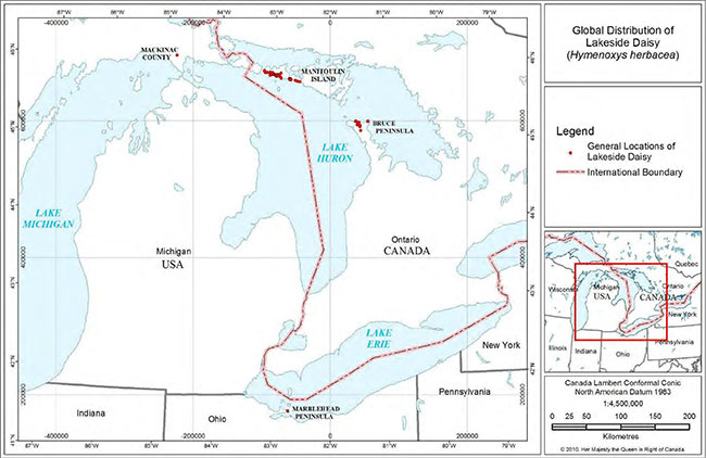
Table 2. Site by site ownership and abundance information for Lakeside Daisy and the number of critical habitat polygons identified. Legend: C = Corporate; CR = Conservation Reserve; FN = First Nation; NGO = non-governmental organization; M = Municipal; NP = National Park; O = Ontario (Crown); PP = Provincial Park; Pr = Private. Note, all municipal sites are in the Township of Burpee-Mills except Burnt Island, now part of Northeastern Manitoulin & Islands (NEMI). JVJ – J. Jalava, 2007, 2008; J2 – J. Jones 1998-2008; JM – J. McGuire, 2006; LC – L. Campbell, 2002 COSEWIC Report; MJO – M. Oldham 1994; M&V – Morton & Venn, 2000 or pers. comm. 2007. *Population counts by LC are consistently higher, sometimes by orders of magnitude, than counts or estimates by other surveyors of the same site.
Bruce Peninsula
| Site Name | Ownership | Approximate abundance of Lakeside Daisy | Number of critical habitat polygons ID'd |
|---|---|---|---|
| Cabot Head | PP | 50,000+ LC* | 2 |
| Dyer’s Bay Rd (incl Bruce Alvar NR) | NP, NGO | 25,000 JVJ | 1 |
| Emmett Lake Road (Saugeen Hunting Grounds) | NP, FN | ~3,200+ JM / ~25,000 LC* |
1 |
| George Lake (BPNP) | NP | 1000's MJO | 1 |
| South of George Lake (BPNP) | NP | 9,700 JVJ | 1 |
| Grotto / Overhanging Rock Point (BPNP) | NP | ~23,650 JM | 2 |
| Halfway Log Dump / Cave Point (BPNP) | NP | ~5,300 JM | 2 |
| West of Cave Point (BPNP) | NP | 6,986 JM | 1 |
| East of Nawash Hunting Grounds | NP | 6,000 JVJ | 1 |
Manitoulin region
| Site Name | Ownership | Approximate abundance of Lakeside Daisy | Number of critical habitat polygons ID'd |
|---|---|---|---|
| Belanger Bay | PP, O | 10,000s J2 | 9 |
| Black Point – Fisher Bay – FisherBay North | Pr, NGO, O | 10,000's J2 | 1 |
| Burnt Is. Harbour, NW of BIH,Christina Bay, BIH boat launch | Pr, PP, O, M | 10,000's J2 | 6 |
| Burnt Island Road | Pr, PP, O | ~100 MJO | 0 |
| Carroll Wood Bay | Pr, O | >1,000,000 LC* | 0 |
| Gatacre Point (E side of Taskerville) | Pr, M | 100's J2 | 0 |
| Greene Island | O | 10,000s J2 | 1 |
| Lorne Lake (Taskerville inland) | Pr | 100's J2 | 0 |
| Lynn Bay | Pr, O | ~5000 J2 | 0 |
| West of Lynn Point | Pr, C, O | 1000's J2 | 0 |
| Misery Bay E. | PP, M | 1000's J2 | 4 |
| Misery Bay W. | Pr, PP, O | ~4 million LC* | 2 |
| Mississagi Lighthouse | C | 608 LC | 0 |
| Murphy Point (Macs Bay) | Pr, M | 3-5000 MJO | 0 |
| Quarry Bay | Pr, PP, NGO,O | 1000's J2 | 18 |
| Rickley Harbour - Girouard Pt. | Pr, PP, O | 1000s J2 | 4 |
| West of Sand Bay | Pr, O | ~1000 LC | |
| Silverwater Radio Towers | Pr | 20-30 MJO | |
| Southwest of Silver Lake | PP | ~10,000s J2 | 1 |
| Taskerville - W. of Portage Point | Pr, M | 1000's J2 | |
| Total: 29 sites | ~3 to 6 million | 58 |
* Population counts by LC are consistently higher, sometimes by orders of magnitude, than counts or estimates by other surveyors of the same site.
Based on recent field work (Jones 2008), the index of area of occupancy (IAO)
On the Bruce Peninsula, all Lakeside Daisy occurrences are in protected areas, except one that also falls partially on First Nations land. Of the 20 occurrences in the Manitoulin Region, portions of 9 occurrences are within protected areas. Some of these portions are extremely large (>77 ha, for example). Thus, of the 29 sites for Lakeside Daisy, 18 are protected either wholly or in part within protected areas (national park, provincial park, or property owned by environmental non-governmental organizations (ENGOs)). Lakeside Daisy populations totaling 260 hectares are within protected areas. See section 2.5 for a list of protected areas where Lakeside Daisy occurs.
2.2 Population and distribution objectives
The goal of this recovery strategy is to maintain over the long-term, self-sustaining populations of Lakeside Daisy in its current range in Canada. Specifically, recovery for Lakeside Daisy in Canada is interpreted as a change in the species status from its current Threatened designation to Special Concern, or lower, as assessed by the Committee on the Status of Endangered Wildlife in Canada (COSEWIC). The population and distribution objectives for Lakeside Daisy are:
- Prevent an overall, continuous decline in the number of populations in each of the two core areas the species occupies (Bruce Peninsula and Manitoulin Region).
- Maintain the species' range at its current index of area of occupancy (114 km2)
footnote 4 and the current extent of occurrencefootnote 5 (2,340 km2).
It should be noted that Lakeside Daisy occupies a restricted and naturally rare habitat type; therefore, even if threats are reduced or mitigated, it will probably always be rare and localized in Ontario and globally.
Rationale:
The objectives above are based on criteria that are used by COSEWIC when assessing a wildlife species' risk of extinction (COSEWIC 2009), and specifically on those under which Lakeside Daisy was designated in 2002 (COSEWIC). The species was designated as Threatened because of its "small distribution range and decline or fluctuation". By meeting these objectives, the recovery goal of long-term persistence of this species throughout its current range can be achieved.
Objective 1: This addresses the previously identified decline in number of populations (COSEWIC 2002). The term "continuous" refers to the COSEWIC indicator of past or future population declines over ten years or three generations (whichever is longer). Thus, one event, for example a Lakeside Daisy alvar flooding out, adjacent to a wetland ecosystem, would not constitute a 'continuous decline'. The maintenance of the species in its two core areas, will potentially preserve the species genetic diversity and local adaptations.
Objective 2: The species' current index of area of occupancy and extent of occurrence are within the range used by COSEWIC to classify a species as Endangered. However, for the species to qualify as Endangered or Threatened, there should also be continuing declines of those values, observed, inferred, or projected. Ensuring that the current extent of occurrence and IAO are maintained, will ensure that Lakeside Daisy populations persist through its current range, and will help prevent the species from being evaluated as "declining" in the future.
2.3 Broad strategies and approaches to recovery
Recovery of Lakeside Daisy will largely be addressed through ecosystem-based actions as well as actions specifically to benefit the species. First and foremost, the broad strategy is to protect remaining examples of high quality alvar that contain Lakeside Daisy. Much good alvar still exists, so rehabilitation of degraded sites is a lower priority and is in no way a substitute for the protection and stewardship of extant high quality sites. Assessing what types of protection are appropriate for individual sites is a high priority.
Recovery efforts for Lakeside Daisy and alvars in the Bruce Peninsula and Manitoulin Region will be done in coordination with the Pitcher’s Thistle - Dune Grasslands recovery team, which is also working in the Manitoulin Island - Lake Huron Region. There is some overlap in membership between the two teams, as well as in agency staff that are handling both recovery efforts. Many threats, actions, and issues are the same in both recovery strategies, so working together will conserve resources, prevent duplication of efforts, and perhaps reduce confusion for stakeholders. The two teams plan to prepare coordinated action plans by 2015. It is recommended that recovery of alvars in the Bruce Peninsula and Manitoulin Region also coordinate with recovery efforts for any other SAR (for example, Massasauga Rattlesnake) being undertaken in the region.
Broad approaches will primarily be protection of existing populations, reduction of threats to habitat, promoting site stewardship, and public education.
1) Protection of existing populations
Evaluation of site-appropriate conservation tools is a required approach because alvars occurin many different types of ownership and jurisdiction, so a variety of different protection measures is needed. Recovery in protected areas will be based on management actions such as monitoring the impact of recreational use (or other threats) on Lakeside Daisy and alvars, constructing barriers or boardwalks to control access, and establishing appropriate zoning for areas with Lakeside Daisy. Outside protected areas, some examples of site-appropriate conservation tools may include tax incentive programs, conservation easements, funding for habitat protection such as fencing, etc. Acquisition of high priority sites, if they become available, may also be an approach. Encouraging compliance and enforcement is also a necessary approach where other management measures fail to protect Lakeside Daisy orother alvar SAR. Approaches and management activities will be guided by the needs of the species as shown by monitoring.
2) Reduction of threats to habitat
Threats reduction will largely be done through protection of existing populations (above), promoting good stewardship (see next). A number of approaches will be required based on threats present, as demonstrated by monitoring. Some approaches may include working with land managers on site-appropriate management such as posting signage and constructing barriers to reduce damage by pedestrians and vehicles. Researchers carrying out field studies, and those conducting monitoring in alvar habitat, need to be cautioned on the potential problem of trampling from their foot traffic, and instructed how to prevent creating such impacts.
3) Promoting site stewardship
Recovery on municipal lands will require coordinating and sharing habitat information withplanning agencies, facilitating discussion of legal and policy approaches, and helping with site-appropriate management planning. Working with the aggregates industry on protection and restoration of alvars during and after extraction will also be an approach. On private and First Nations lands, actions will require working cooperatively with owners on best management practices.
4) Public education
Communications to engage the public in valuing and protecting alvars is vital. A key toencouraging good stewardship is helping landowners and managers understand what they have on their lands. As well, many alvars on municipal lands have a public right-of-way through them, so educating the public about conscientious use will also be an approach. For populations occurring on First Nation lands, communications and outreach will be needed to gain assistance from the community in protecting alvars and Lakeside Daisy habitat. Cooperating with local partners, such as local stewardship councils, fish and game clubs, etc., to promote awareness and protection of publicly accessible alvars, will also be necessary.
Timelines and benchmarks for these goals are given in Section 2.6 Measuring Progress.
2.4 Critical habitat
Critical habitat is defined in section 2(1) of the Species at Risk Act (2002) as "the habitat that is necessary for the survival or recovery of a listed species and that is identified as the species critical habitat in the recovery strategy or in an action plan for the species". In a recovery strategy, critical habitat is identified to the extent possible, using the best available information. Ultimately, sufficient critical habitat will be identified to completely support the population and distribution objectives.
The critical habitat identified in this recovery strategy contributes to a substantial portion of the targets outlined in objectives 1 and 2 (Section 2.2), but does not fully meet the objectives. In total, 58 polygons totaling 260 hectares are identified at 18 sites on the Bruce Peninsulaand the Manitoulin Region, capturing some of the largest populations of the species, covering over 50% of the total index of area of occupancy, and over 80% of the total extent of occurrence. Recent surveys funded by the Species at Risk Program have resulted in many extensions to the known distribution of Lakeside Daisy. At this time, we do not have adequate information to determine which of those populations should be identified as critical habitat to achieve the objectives. A schedule of studies, which outlines the work required to complete the identification of critical habitat, is included below (see Section 2.4.4). In the meantime, implementation of the broad strategies and approaches listed in 2.3, will aid in meeting the population and distribution objectives.
2.4.1 Information used to identify critical habitat locations and attributes
Critical habitat was identified using confirmed records on The Bruce Peninsula and in provincial parks, crown lands, and lands owned by non-governmental organizations (ENGOs) in the Manitoulin Region.
Lakeside Daisy has a very narrow habitat preference (Jalava 2008; Brownell and Riley 2000; Reschke et al. 1999) and is restricted to alvar pavements. This habitat can occur as part of several open vegetation community types on The Bruce and Manitoulin Region (Lee et al. 1998), including:
ALO1-1 Dry Lichen-Moss Open Alvar Pavement
ALO1-3 Dry-Fresh Little Bluestem Open Alvar Meadow
ALS1-1 Common Juniper Shrub Alvar
ALS1-2 Creeping Juniper - Shrubby Cinquefoil Dwarf Shrub Alvar
ALS1-3 Scrub Conifer - Dwarf Lake Iris Shrub Alvar
ALT1-4 Jack Pine - White Cedar - White Spruce Treed Alvar
BBO2 Carbonate Bedrock Open Beach
The boundaries between alvars and other community types (e.g. forest, wetland) are often quite distinct, making them relatively easy to distinguish in the field and relatively straightforward to map.
2.4.2 Critical habitat identification
Critical habitat on the Bruce Peninsula and the Manitoulin Region is identified using confirmed Lakeside Daisy population (or sub-population) occurrence data and the mapped boundaries of suitable alvar communities. Occurrence data for Lakeside Daisy on the Bruce Peninsula and the Manitoulin Region were gathered from all available sources (especially Ontario Natural Heritage Information Centre, Parks Canada, and Jalava 2008), scrutinized and updated in 2009 and 2010 by a core group of Alvar Recovery Team members. All populations (or sub-populations) of Lakeside Daisy on the Bruce Peninsula were plotted digitally on 2006 orthophotography with 30 cm resolution (South Western Ontario Orthorectification Project 2006), and alvar community polygons as mapped by Jalava (2008) were superimposed on these to show which alvar polygons are occupied by the species.Where alvar community polygons encompass occurrences of Lakeside Daisy, those alvars are considered to be critical habitat. The entire alvar community polygons were identified as critical habitat to accommodate natural expansion of Lakeside Daisy populations within. Critical habitat polygon boundaries are the distinct change between alvar community and other vegetation community types.
For the Manitoulin Region, all records from protected areas were superimposed on Quickbird imagery (6 satellite images at 60 centimeter resolution with a date range of June 2005-August 2008). As well, field mapping from hard copies (IACI unpublished field notes 1995 and 1996 on file with NHIC) was scanned and superimposed on satellite imagery to show the extent of Lakeside Daisy within alvar polygons. Again, where alvars contain Lakeside Daisy occurrences, the entire alvar community polygon is identified as critical habitat.
Only Lakeside Daisy records with associated GPS coordinates or that were mapped precisely in the field on aerial photos were used to identify alvar polygons for critical habitat. Older pre-GPS records with poor or vague location data were superceded by newer observations of those same populations, so that only the most up-to-date information was used to identify which alvars would be critical habitat.
In the absence of disturbance associated with human activity, the sites where Lakeside Daisy populations occur are ecologically quite stable, and typically remain very sparsely vegetated for centuries (Jones and Reschke 2005; Reschke et al. 1999). Thus, the critical habitat boundaries identified here should apply for at least the next 10 to 20 years. It is recommended that the critical habitat boundaries identified here should be evaluated on a 10 year basis, to coincide with the cycle of COSEWIC evaluation of the species.
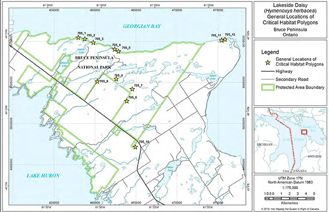
In total, 12 critical habitat polygons are identified at 9 sites on the Bruce Peninsula and 46 polygons are identified at 9 sites in the Manitoulin Region (some sites have more than one polygon; some sites are very large). The general locations of critical habitat polygons are depicted in Figures 3 and 4, with detailed maps showing the extent of each critical habitat polygon provided in Appendix B. The number of polygons at each site is shown in Table 2 in Section 2.1. Note that the number of polygons is not necessarily a good indicator of the amount of critical habitat identified, as polygon size ranges from <1/2 hectare to >77 hectares. GIS shapefiles of all the critical habitat polygons are maintained by the Federal Government.
The biophysical attributes of critical habitat include the following;
- Naturally open, sparsely treed (<60% canopy cover) areas on Silurian dolostone bedrock, on or within a few kilometers of the Lake Huron or Georgian Bay shore;
- Exposed bedrock is present; cracks, crevices, or small patches of sand on top of bedrock are present;
- Poorly drained, and water pools on top of the bedrock; most water leaves by evaporation;
- Shallow soil (<20 cm) with bare bedrock exposed; due to lack of drainage, soil exists for prolonged periods in extreme states of drought or flooding;
- Vegetation cover is very sparse, often appearing as barren; vegetation may be growing only from cracks or crevices or on patches of mosses or lichens;
- Dominant vegetation may be grass, or patches of low shrubs, or Lakeside Daisy itself, with or without scattered trees.
2.4.3 Activities likely to result in the destruction of critical habitat
Examples of activities that are likely to result in the destruction of Lakeside Daisy critical habitat are listed here with the habitat features or properties they are likely to destroy. These activities would be destructive in any part of critical habitat.
Activities that destroy or remove alvar vegetation:
- Building cottages, houses, and driveways on alvar
- Building roads across alvar ecosystems
- Limestone/dolostone quarrying or removing surface material such as boulders
- Removing vegetation or clearing of soil
- Using alvar as landing areas or access routes during the logging of adjacent forests.
Activities that disturb the extremely shallow soil:
- Driving heavy machinery across alvar vegetation
- Off-trail ATV use.
Activities that reduce native species presence and introduce exotic and potentially invasive species:
- Trucking-in fill, dirt and gravel
- Off-trail ATV use as a vector for weeds
- Seeding lawns or planting non-native species
- Planting trees.
Activities that trample and damage vegetation and soil:
- Off-trail usage by hikers or off-trail ATV use that tramples or destroys vegetation
- Camping activities such as placing a tent, fire pit, or latrine on alvar ecosystems
- Use of habitat by large groups for events.
Activities that interrupt natural ecological processes:
- Fire suppression (in alvar types which have had a history of fire) leading to closing-in anddisappearance of habitat.
- Intentional burning (in other alvar types where there is little evidence of past fire) leading to destruction of the habitat.
There are several instances where trail use is beneficial to Lakeside Daisy because the light disturbance keeps the ground clear of other vegetation. Threshold levels at which trail usage could become harmful rather than beneficial have not been determined; thus, it is intended here that generally the use of existing trails and roads within critical habitat may continue. The determination of the point at which trail usage may potentially become harmful and protective action needed, is more appropriately handled by park management on a site by site basis.
2.4.4 Schedule of studies to identify critical habitat
This document includes a partial identification of critical habitat for Lakeside Daisy. Future identification of critical habitat elsewhere in the range of Lakeside Daisy will be undertaken as needed to ensure population and distribution objectives are met, or if the degree of risk affecting the species increases. Table 2 outlines and explains the work required to enable further critical habitat identification and mapping.
| Description of Activity | Outcome/Rationale | Timeline |
|---|---|---|
| Update occurrence data & mapping for allremaining sites from the 1995/96 Alvar Project, to current CH standards. | Complete and currentoccurrence data set & mapping permits creation of accurate CH polygons for remaining Manitoulin Region populations. | Could piggyback onfieldwork for COSEWIC Status Report Update due in 2012 |
| Identify CH parcels to meet thepopulation & distribution objectives, e.g. IAO of 114 km2 & EO of 2,340 km2. | To meet recovery objectives. | As required |
2.5 Habitat conservation
Critical habitat is identified for a total of 18 Lakeside Daisy sites found wholly or in part within protected areas
The Bruce Peninsula
Ontario Nature:
Bruce Alvar Nature Reserve (8.2 hectares)
Ontario Parks:
Cabot Head Provincial Nature Reserve (4.9 hectares)
Parks Canada:
George Lake Alvar (5.3 hectares)
South of George Lake (0.3 hectares)
Overhanging Rock Point (2.2 hectares)
Halfway Log Dump (1.3 hectares)
West of Cave Point (0.4 hectares)
Emmett Lake Road (0.2 hectares)
East of Nawash Hunting Grounds (1.1 hectares).
Manitoulin Island
Escarpment Biosphere Conservancy:
Black Point (11.3 hectares)
Ontario Parks:
Queen Elizabeth-Queen Mother M'nidoo M'nissing Provincial Park
Quarry Bay (42.7 hectares)
Belanger Bay (63 hectares)
Rickley Harbour – Girouard Point (15 hectares)
Burnt Island Harbour – Christina Bay (16.8 hectares)
Southwest of Silver Lake (0.6 hectares)
Misery Bay Provincial Park
East Side (11.4 hectares)
West Side (74 hectares)
Ontario Crown Land:
Green Island (1.4 hectares).
2.6 Measuring progress
The success of Lakeside Daisy recovery will be evaluated by comparing information from monitoring and inventory with the Population and Distribution Objectives, as per Table 3. Each of the criteria is directly linked to one or more of the key objectives of this recovery strategy, as indicated.
| Criterion | Links to Objective # | Evaluation Timeframe (years after final posting of recovery strategy) |
|---|---|---|
| Monitoring program will be implemented for all priority sites. | 1, 2 | 3 |
| Some forms of habitat protection will have begun to be put inplace (protective park management, confirmation of ANSI status at some sites, etc.). | 1, 2 | 5 |
| Threats assessment completed and an evaluation of how toaddress current threats. | 1, 2 | 3 |
| Threats to habitat will begin to be addressed e.g. barriers toprevent ATV use or visitor trampling. | 1, 2 | 2 |
| Communications strategy developed for the alvars of the BrucePeninsula and Manitoulin Region will be developed, with information distributed to private landowners about stewardship practices. | 1, 2 | 5 (CS) 5+ (outreach info.) |
| A dialogue will have begun with First Nations, municipalities,and corporate quarry owners, about stewardship possibilities. | 1, 2 | 3 |
| No overall, continuous decline in the number of populations ineach of the 2 core areas. | 1 | Measured over 10 years or 3 generations* |
| No continuous decline in the index of area of occupancy. | 2 | Measured over 10 years or 3 generations |
| No continuous decline in the extent of occurrence. | 2 | Measured over 10 years or 3 generations |
* This time frame is adopted from the COSEWIC assessment criteria, to account for anomalies within a shorter time frame.
2.7 Statement on Action Plans
One or more Action Plans will be completed by December 2015.
3.0 References
Bakowsky, W.D. 1996. Vegetation Communities of Southern Ontario. OMNR Natural Heritage Information Centre, Peterborough.
Bazely, Dr. D. 2004. Personal communication. Department of Environmental Studies, York University, Toronto, Ontario
Bouchard, P. 1998. Insect diversity in alvars of Southern Ontario. Report presented to the Federation of Ontario Naturalists, Don Mills, Ontario. Iv + 87 pp.
Bouchard, Dr. P. 1996. Personal communication with Judith Jones. Entomology Section, Agriculture Canada, Ottawa, Ontario.
Brownell, V.R. and J.L. Riley. 2000. The Alvars of Ontario: Significant Natural Areas in the Ontario Great Lakes Region. Federation of Ontario Naturalists, Don Mills, Ontario. 269 pp.
Bruce Peninsula and Manitoulin Island Alvar Recovery Team. 2009. Identification of Lakeside Daisy critical habitat: justification for boundaries of individual polygons. Unpublished document on file with the chair of the recovery team. Parks Canada, Ottawa. 8 pp and accompanying database and shape files.
Campbell, L.G. 2001. Pollen limitations in small populations of the self-incompatible plant, Hymenoxys herbacea. Masters thesis. University of Guelph, Guelph, Ontario.
Catling, P.M. 1995. The extent of confinement of vascular plants to alvars in Southern Ontario. Canadian Field Naturalist 109:172-181.
Catling P.M. and V.R. Brownell. 1998. Importance of fire in the maintenance of distinctive, high biodiversity plant communities on alvars – evidence from the Burnt Lands, eastern Ontario. Canadian Field Naturalist 112:661-667.
Catling P.M. and V.R. Brownell. 1993. Floristic composition, phytogeography and relationships of prairies, savannas and sand barrens along the Trent River, Eastern Ontario. Canadian Field Naturalist 107(1):24-45.
COSEWIC. 2002. COSEWIC assessment and status report on Lakeside Daisy (Hymenoxys herbacea) in Canada. Committee on the Status of Endangered Wildlife in Canada. Ottawa. vi+ 24 pp.
COSEWIC. 2009. Wildlife Species Assessment. COSEWIC's Assessment Process and Criteria. Government of Canada.
Couchiching Conservancy. 1996. Carden Plain Habitat Conservation: A report of the Carden Alvar Project. Couchiching Conservancy, Orillia, Ontario. 29 pp.
DeMauro, M.M. 1993. Relationship of breeding system to rarity in the Lakeside daisy (Hymenoxys acaulis var. glabra). Conservation Biology 7(3): 542-550.
Derecki, J.A. 1985. Effect of channel changes in the St. Clair River during the present century. Journal of Great Lakes Resources 11(3):201-207. International Association of Great Lakes Resources.
Environment Canada. 2005. Policy on the Feasibility of Recovery in Renew Recovery Handbook (ROMAN), working draft. Recovery Secretariat, Canadian Wildlife Service, Environment Canada, Ottawa, Ontario.
Esselman, E.J., J.J. Windus and K.E. Cochrane. 2000. Examination of isozyme diversity within and between populations of Hymenoxys herbacea (E.L. Greene) Cusick = Hymenoxys acaulis var. glabra (Lakeside Daisy). U.S. Fish and Wildlife Service, Twin Cities, Minnesota.
Gilman, B.A. 1995. Vegetation of Limerick Cedars: Pattern and Process in Alvar Communities. Ph.D. thesis, SUNY College of Environmental Science and Forestry, Syracuse, NY. 322 pp.
Jalava, J.V. 2008. Alvars of the Bruce Peninsula: A Consolidated Summary of Ecological Surveys. Prepared for Parks Canada, Bruce Peninsula National Park, Tobermory, Ontario. iv+ 350 pp + appendices.
Jalava, J.V. 2008-1996. Unpublished field data and mapping on file with the Natural Heritage Information Centre (NHIC), Ontario Ministry of Natural Resources, Peterborough.
Jalava, J.V. 2007. Species at Risk Inventory: Hill’s Thistle (Cirsium hillii). Prepared for Parks Canada Agency, Bruce Peninsula National Park/Fathom Five National Marine Park, Tobermory, Ontario. 15pp.
Jalava, J.V. 2004a. Biological Surveys of Bruce Peninsula Alvars. Prepared for Nature Serve Canada, Ontario Natural Heritage Information Centre and Parks Canada. iii + 21 pp.
Jalava, J.V. 2004b. Life science inventory of the Cameron Ranch Provincial Nature Reserve. Report to Ontario Parks.
Jalava, J.V. 1998. Alvar stewardship packages. Ontario Natural Heritage InformationCentre Newsletter 4(2): 14.
Jones, J.A. 2008-1995. Unpublished field data and mapping on file at the Natural Heritage Information Centre, OMNR, Peterborough.
Jones, J.A. 2007. Report from the 2007 Species-At-Risk surveys on the Wikwemikong Reserve. Prepared for the Wikwemikong Lands Office, Wikwemikong, Ontario. 18 pp.
Jones, J.A. 2005. More alvars of the North Channel Islands and the Manitoulin Region: Report prepared for Ontario Ministry of Natural Resources, Espanola Office.
Jones, J.A. 2004. Alvars of the North Channel Islands. Report to Nature Serve Canada, Ottawa, Ontario.
Jones, J.A. 2000. Effectiveness of hand-pulling the invasive Mossy Stonecrop (Sedum acre) from alvar pavements. Michigan Botanist 39 (3): 43-50.
Jones, J.A. 1998. Manitoulin’s Flat Rock Country: a landowner’s guide to a special habitat. Federation of Ontario Naturalists, Don Mills, Ontario. 17 pp.
Jones, J.A. and Reschke, C. 2005. The role of fire in Great Lakes alvar landscapes. Michigan Botanist (44) 1: 13-27.
Koh, S. and D.R. Bazely. 1999. The role of browsing and grazing in alvar communities. Report to the Federation of Ontario Naturalists, Don Mills, Ontario. 13 pp.
Lafontaine, J.D. and Schweitzer, D.F. 2004. Dichagyris (Mesembragrotis) reliqua (Noctuoidea) in Lafontaine, J.D., and Gill, eds. Moths of North America. Fascicle 27:1: 118-119.
Lee, H.T., W.D. Bakowsky, J. Riley, J. Bowles, M. Puddister, P. Uhlig and S. McMurray1998. Ecological Land Classification for Southern Ontario: First Approximation and Its Application. OMNR, Southcentral Science Section, Science Development and Transfer Branch. SCSS Field Guide FG-02. 225 pp.
Massasauga Recovery Team. 2005. National recovery strategy for the Massasauga (Sistrurus catenatus). Draft prepared for Parks Canada Agency, Ottawa.
McGuire, J. 2006. Lakeside Daisy (Hymenoxys herbacea) Inventory Report. Bruce Peninsula National Park, Tobermory, ON. 5 pp.
Morton, J.K. and J.M. Venn. 2000. The Flora of Manitoulin Island, 3rd ed. University of Waterloo Biology Series Number 40. Waterloo, Ontario.
Natural Heritage Information Centre (NHIC). 2009. Element occurrence, natural areas and Ontario Herpetofaunal Summary databases and species lists. Natural Heritage Information Centre, Ontario Ministry of Natural Resources, Peterborough, Ontario. On-line electronic databases.
NatureServe, 2009. On line Explorer. http://www.natureserve.org
Oldham, M.J. and S.R. Brinker. 2009. Rare Vascular Plants of Ontario, Fourth Edition. Natural Heritage Information Centre, Ontario Ministry of Natural Resources. Peterborough, Ontario. 188 pp.
Oldham, M.J. and T. Kraus. 2002. COSSARO Candidate V,T,E Species Evaluation Form for Lakeside Daisy (Hymenoxys herbacea). Prepared by Natural Heritage Information Centre for Committee on the Status of Species at Risk in Ontario (COSSARO), Ontario Ministry of Natural Resources, Peterborough, Ontario. 7 pp. + appendices.
Ontario Aggregate Resources Corporation. 2009. Annual Report. Burlington, Ontario.
Pärtel, M., R. Kalamees, M. Zobel and E. Rosén. 1999. Alvar grasslands in Estonia:variation in species composition and community structure. Journal of Vegetation Science 10:561-570.
Reschke, C., R. Reid, J. Jones, T. Feeney and H. Potter. 1999. Conserving Great Lakes Alvars: Final Technical Report of the International Alvar Conservation Initiative. The Nature Conservancy, Chicago, Illinois. 230 pp.
Schaefer, C.A. 1996. Comments on the role of fire in Bruce Peninsula alvars. Prepared for the Federation of Ontario Naturalists, Don Mills, Ontario. 6pp.
Schaefer, C.A. and D.W. Larson. 1997. Vegetation, environmental characteristics and ideas on maintenance of alvars on the Bruce Peninsula, Canada. Journal of Vegetation Science8:797-810.
South Western Ontario Orthorectification Project (SWOOP). 2006. Orthophotography forSouthern Ontario. www.swoop2010.ca [ Link no longer active. ]
Stephenson, S.N. 1995. Annual report to The Nature Conservancy on long-term monitoring activities on the Maxton Plains Preserve. 23 pp.
4.0 Recovery team members
Chair
Gary Allen
Species at Risk Recovery Specialist, Parks Canada, Ottawa
Recovery Team
Wasyl Bakowsky
Community Ecologist, Natural Heritage Information Centre, OMNR Peterborough
Vivian Brownell
Consulting Biologist, Metcalfe, Ontario
Frank Burrows
Park Superintendent, Bruce Peninsula/Fathom Five Marine National Parks, Tobermory
Anthony Chegahno
Chippewas of Nawash First Nation
Jarmo Jalava
Consulting Ecologist, Paisley, ON
Judith Jones
Winter Spider Eco-Consulting, Sheguiandah, ON
Dan Kraus
Conservation Science Manager, Ontario Region, Nature Conservancy Canada, Guelph
April Mathes
Stewardship Coordinator – Nature Reserves, Ontario Nature, Toronto
Angela McConnell
Species at Risk Biologist, Canadian Wildlife Service, Downsview
Ethan Meleg
Outreach Coordinator, Bruce Peninsula National Park, Tobermory
Dr. John Morton
Professor Emeritus, Dept. of Biology, University of Waterloo
Roxanne St Martin
Species at Risk Biologist, Ontario Ministry of Natural Resources, Southern Region
Recovery team advisors
Paul M. Catling
Research Scientist and Curator, Agriculture and Agri-food Canada, Ottawa
Eric Cobb
Species at Risk Biologist, Ontario Ministry of Natural Resources, Sudbury
John Grant
Nature Conservancy of Canada, Ontario Region, Guelph
Will Kershaw
Management Planner, Ontario Parks Northeast Zone, Sudbury
Douglas Larson
Professor Emeritus, Department of Botany, University of Guelph
Steve Marshall
Department of Environmental Biology, University of Guelph
Ed Morris
Parks Ecologist, Ontario Parks Northeast Zone, Sudbury
Mike Oldham
Botantist/Herptologist, Natural Heritage Information Centre, OMNR, Peterborough
Chris Risley
Species at Risk Regulation, Ontario Ministry of Natural Resources Peterborough
Appendix A Globally and provincially rare species of the Bruce Peninsula and Manitoulin Region Alvar Ecosystems
G and S ranks from Oldham and Brinker (2009) and NHIC (2009).
| Common Name | Scientific Name | Grank/Srank | COSEWIC | SAR in Ontario List |
|---|---|---|---|---|
| Gattinger’s Agalinis | Agalinis gattingeri | G4S2 | END | END |
| Lakeside Daisy | Hymenoxis herbacea | G2S2 | THR | THR |
| Hill’s Thistle | Cirsium hillii | G3S3 | THR | THR |
| Dwarf Lake Iris | Iris lacustris | G3S3 | THR | THR |
| Houghton’s Goldenrod | Solidago houghtonii | G3S2 | SC | THR |
| Tuberous Indian Plantain | Arnoglossum plantagineum | G4G5S3 | SC | SC |
| Green Milkweed | Asclepias viridiflora | G5S2 | ||
| Cooper’s Milk-vetch | Astragalus neglectus | G3G4S3 | ||
| Ram’s Head Orchid | Cypripedium arietinum | G3S3 | ||
| Laurentian Fragile Fern | Cystopteris laurentiana | G2G4S2S3 | ||
| Limestone Oak Fern | Gymnocarpium robertianum | G5S2 | ||
| Cylindric Blazing Star | Liatris cylindracea | G5S3 | ||
| Grooved Yellow Flax | Linum sulcatum | G5S3 | ||
| Fascicled Cancer-root | Orobanche fasciculata | G4S1 | ||
| Round-leaved Ragwort | Packera obovata | G5S3 | ||
| Purple-stemmed Cliff-brake | Pellaea atropurpurea | G5S3 | ||
| Low Nut-rush | Scleria verticillata | G5S3 | ||
| Northern Dropseed | Sporobolus heterolepis | G5S3 | ||
| Oregon Woodsia | Woodsia oregana | G5S3 |
Non-vascular plants
| Common Name | Scientific Name | Grank/Srank | COSEWIC | SAR in Ontario List |
|---|---|---|---|---|
| Moss | Limprichtia cossonii | G?S2 | ||
| Moss | Pseudocalliergon turgescens | G3G5S2 | ||
| Lichen | Psora decipiens | G?S1S2 |
Vertebrate Fauna
| Common Name | Scientific Name | Grank/Srank | COSEWIC | SAR in Ontario List |
|---|---|---|---|---|
| Massasauga Rattlesnake | Sistrurus catenatus catenatus | G3G4S3 | THR | THR |
| Eastern Milksnake | Lampropeltis triangulum | G5S3 | SC | SC |
| Eastern Ribbonsnake | Thamnophis sauritus | G5S3 | SC | SC |
Invertebrate Fauna
| Common Name | Scientific Name | Grank/Srank | COSEWIC | SAR in Ontario List |
|---|---|---|---|---|
| Olympia Marble | Euchloe olympia | G4G5S3? | ||
| Large Marble Butterfly | Euchloe ausonides | G5S3 | ||
| Garita Skipper | Oarisma garita | G5S1 | ||
| Dark Crescent | Phyciodes batesii | G3G4S3 | ||
| Double-banded Zale | Zale calycanthata | G?S1? | ||
| Prairie Meadow Katydid | Conocephalus saltans | G?S1S3 | ||
| Great Lakes Alvar Moth | Dichagyris reliqua | not ranked* | ||
| Striped Camel Cricket | Ceuthophilus meridionalis | G?S2S3 | ||
| A tiger Beetle | Cidinella sexguttatai | G4S3? | ||
| A mollusc | Catinella aprica | G3S2 | ||
| A mollusc | Catinella exile | G1G2S1 | ||
| A mollusc | Euchemotrema leai | G5S2S3 | ||
| A mollusc | Euconulus alderi | G?S3S4 | ||
| A mollusc | Glyphyalinia solida | G?S3S4 | ||
| A mollusc | Succinea indiana | G?S2 | ||
| A mollusc | Vertigo cristata | G?S3S4 | ||
| A mollusc | Vertigo elatior | G2G3S2S3 | ||
| A mollusc | Vertigo morsei | G1G2S1 | ||
| A mollusc | Vertigo pygmaea | G4S2S3 | ||
| A mollusc | Vertigo ventricosa | G3S2S3 |
*only known in Canada from 5 alvars in the Manitoulin Region (Lafontaine and Schweitzer 2004).
Appendix B Critical habitat maps for the Bruce Peninsula and Manitoulin Region
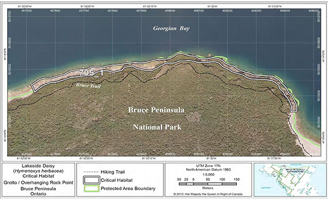
Figure 5. Fine-scale map of Lakeside Daisy critical habitat parcell on the northern Bruce Peninsula
American pelican
Note: The term "Protected Area" used in the critical habitat maps has no relation to protection requirements under SARA
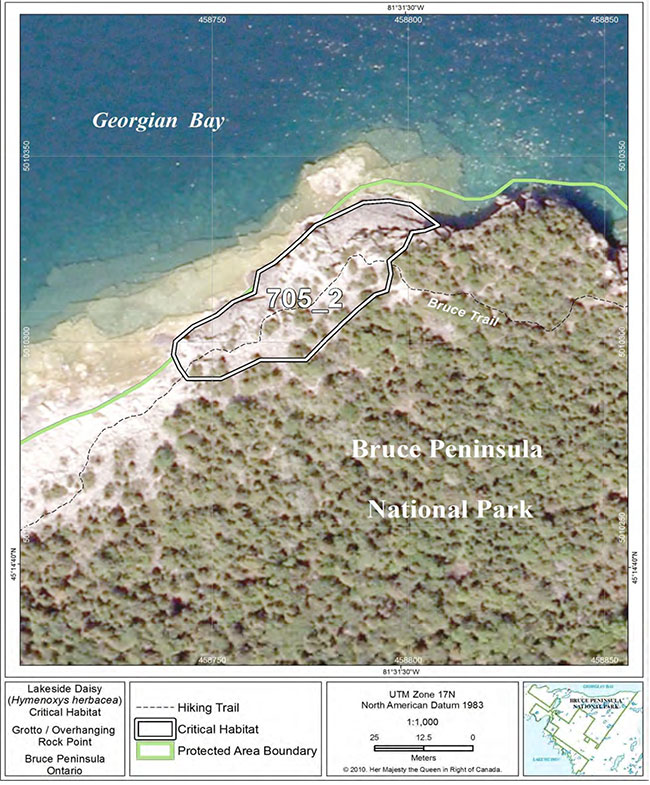
Figure 6. Fine-scale map of Lakeside Daisy critical habitat parcel 2 on the northern Bruce Peninsula.
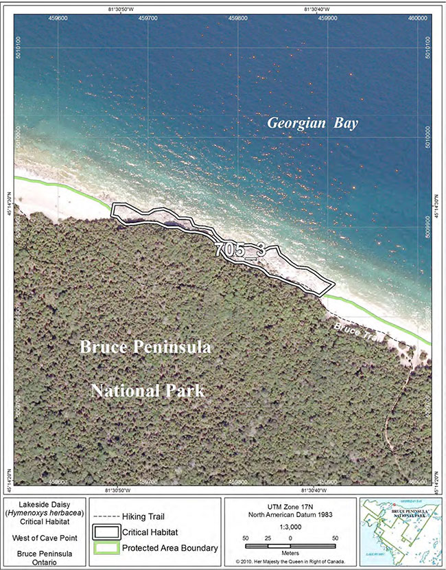
Figure 7. Fine-scale map of Lakeside Daisy critical habitat parcel 3 on the northern Bruce Peninsula.
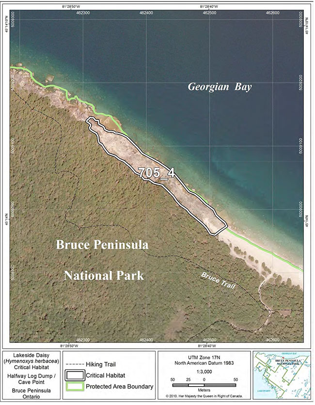
Figure 8. Fine-scale map of Lakeside Daisy critical habitat parcel 4 on the northern Bruce Peninsula.
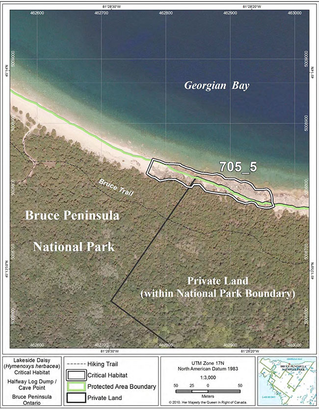
Figure 9. Fine-scale map of Lakeside Daisy critical habitat parcel 5 on the northern Bruce Peninsula.
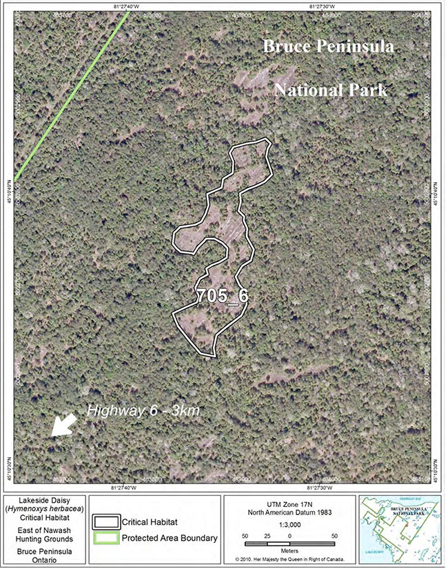
Figure 10. Fine-scale map of Lakeside Daisy critical habitat parcel 6 on the northern Bruce Peninsula.
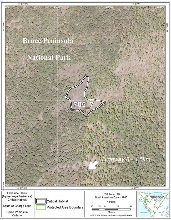
Figure 11. Fine-scale map of Lakeside Daisy critical habitat parcel 7 on the northern Bruce Peninsula.
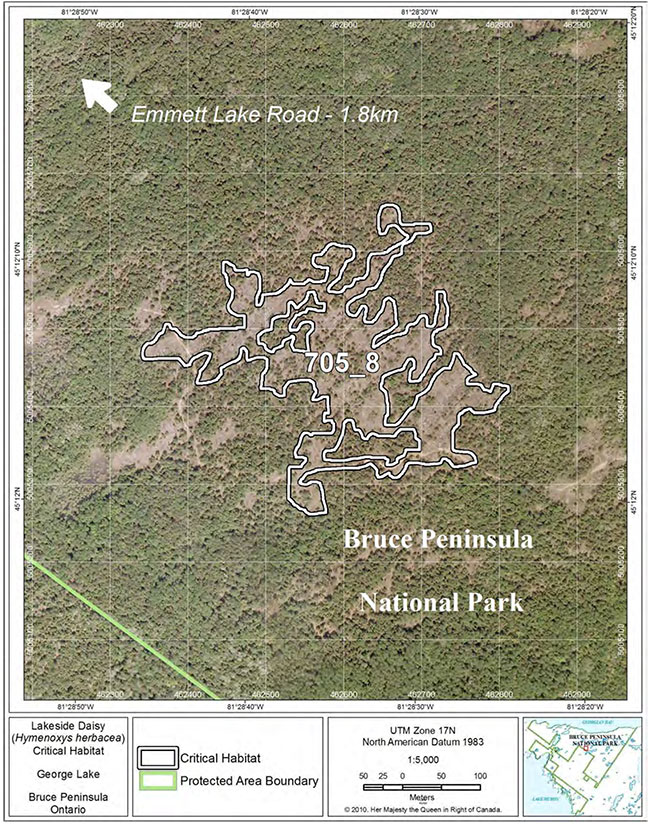
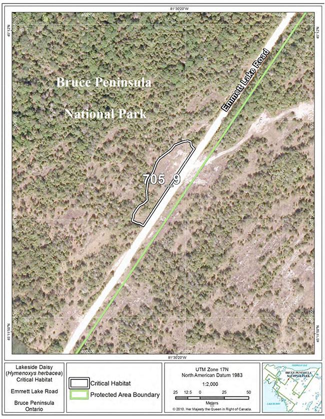
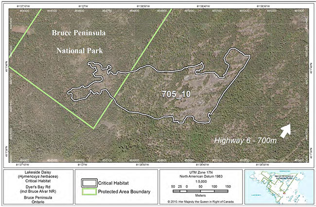
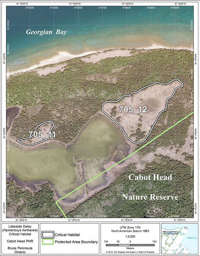
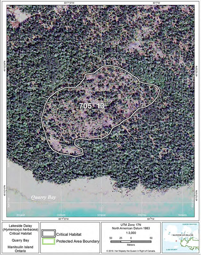
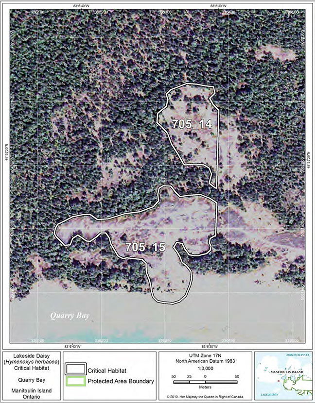
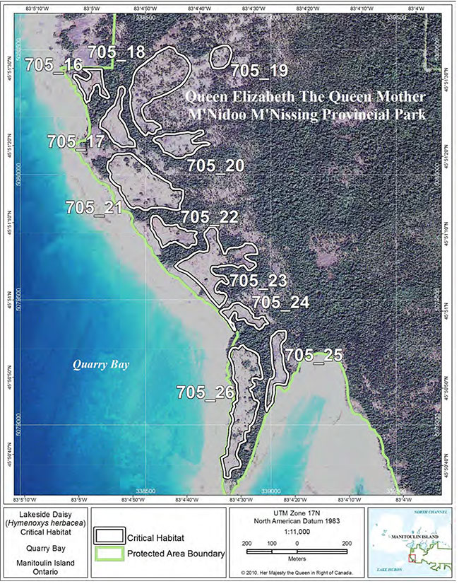
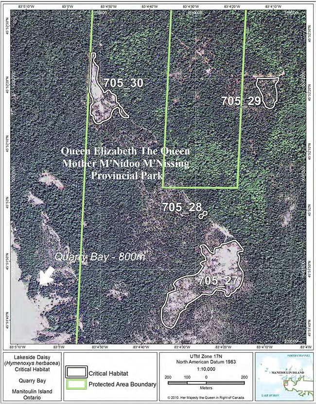
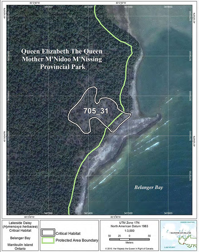
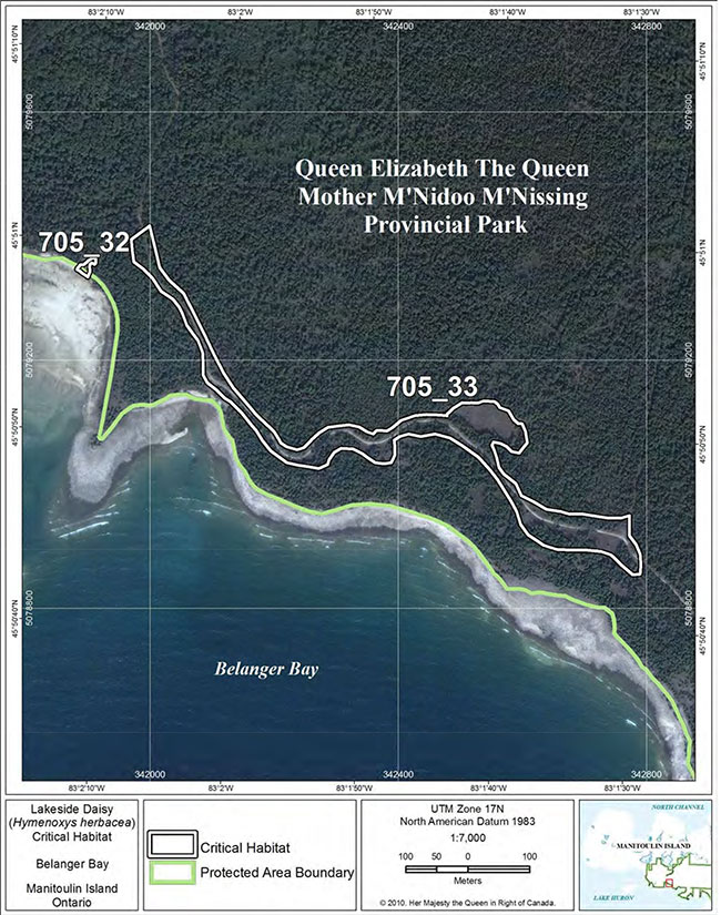
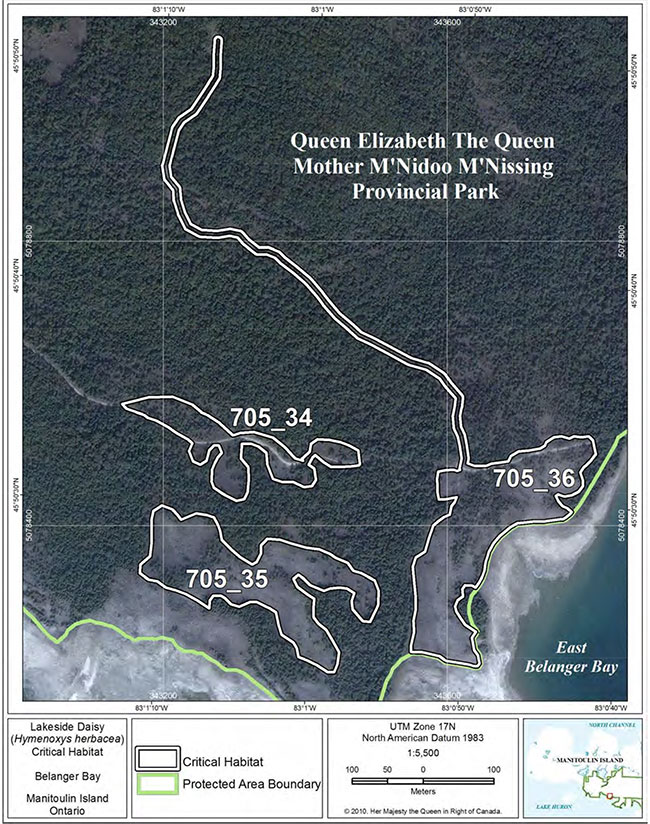
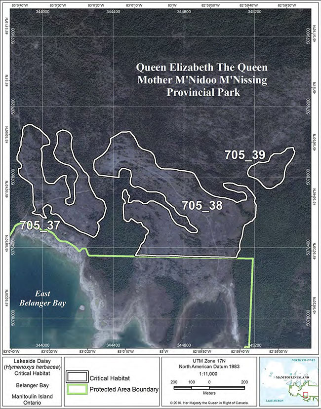
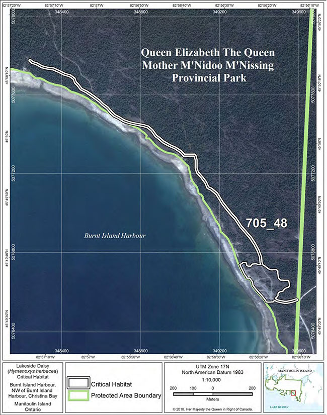
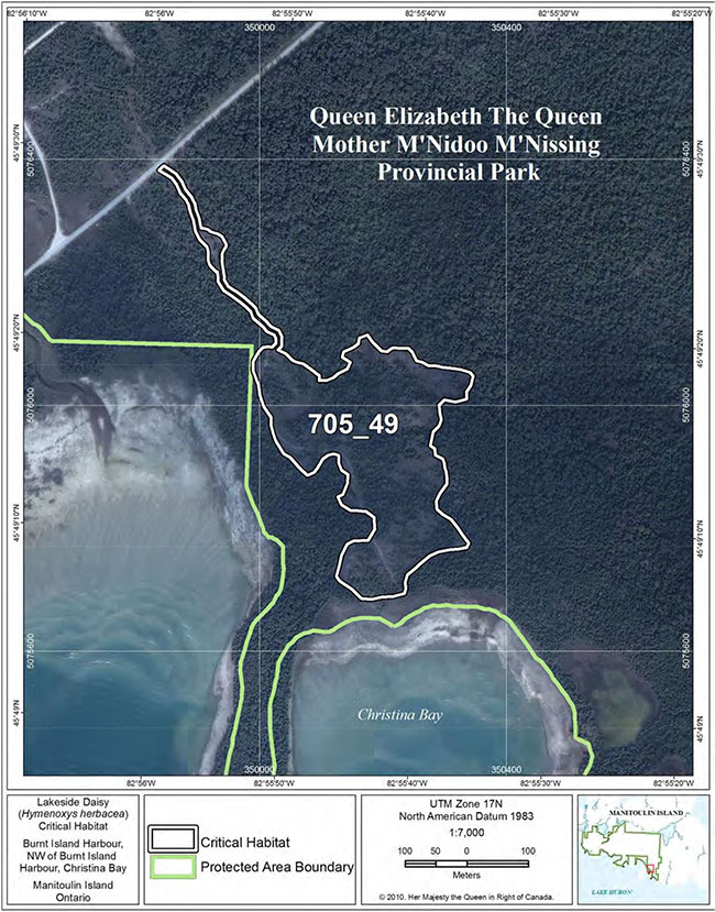
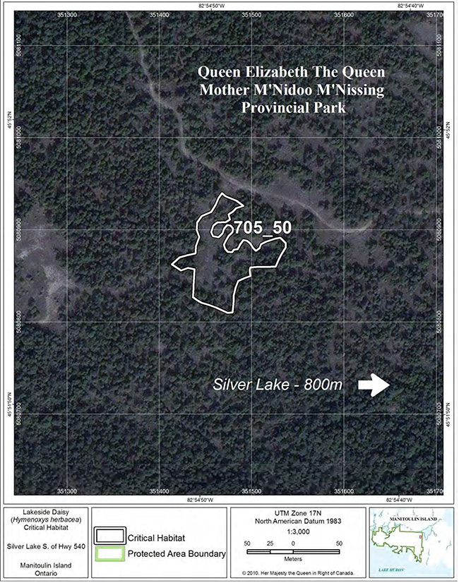
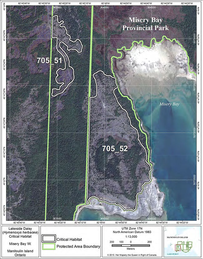
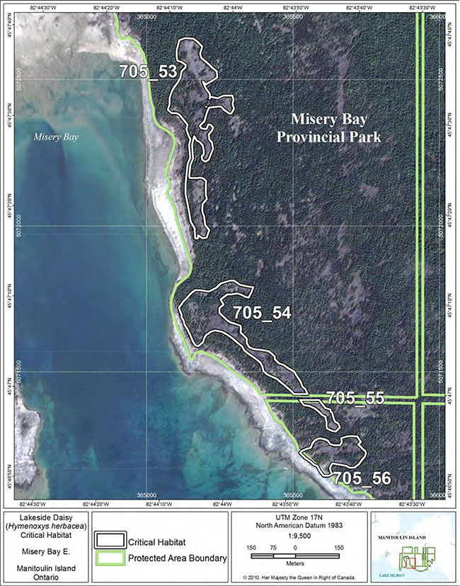
/p>
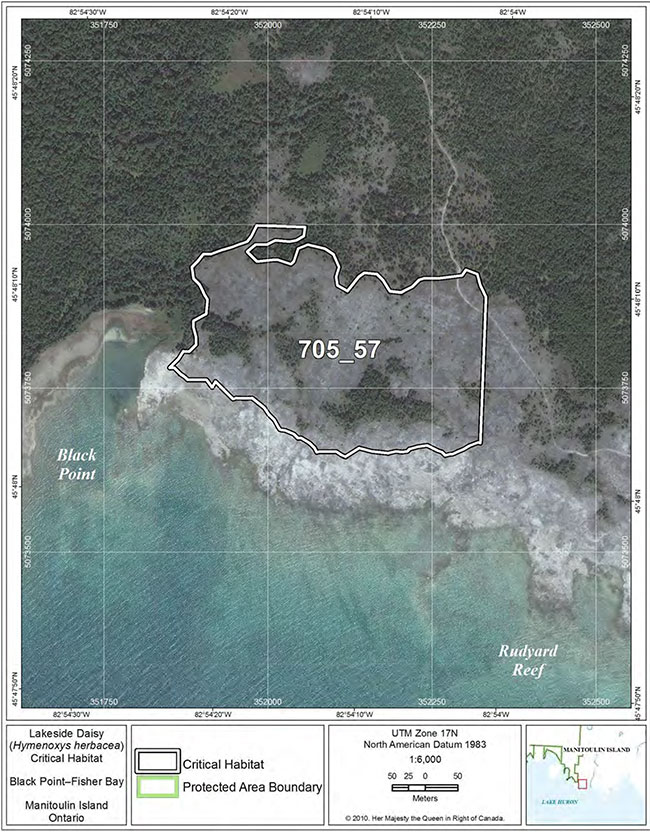
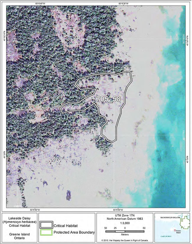
Footnotes
- footnote[1] Back to paragraph "Alvar" is a Swedish word, originally used for the grasslands on the islands of Öland and Göteland in the Baltic Sea. In the Great Lakes basin, "alvar" refers to naturally open areas with shallow soils over relatively flat, limestone bedrock, with trees absent or at least not forming a continuous canopy (Reschke et al. 1999, Brownell and Riley 2000). There are several different kinds of alvars (just as there are different kinds of forests), and each type has a distinctive group of species present.
- footnote[2] Back to paragraph A site or element occurrence (EO) may include several populations (sometimes call subpopulations), which are considered together if they are within 1 km proximity of each other. Population is a general term to discuss clusters of plants without specifically discussing the boundaries of the area.
- footnote[3] Back to paragraph Index of area of occupancy is an estimate of the number of 1X1 km grid squares occupied by extant populations.
- footnote[4] Back to paragraph This IAO is a estimate calculated by Parks Canada for this recovery strategy, using all available information, much of it more recent than COSEWIC (2002) (see details above in 2.1).
- footnote[5] Back to paragraph Extent of occurrence is the area included in a polygon without concave angles that encompasses the geographic distribution of all known populations of a wildlife species (COSEWIC 2009).
- footnote[6] Back to paragraph Some patches of ALO1-1 and ALO1-3 in which Lakeside Daisy is found are smaller than 0.5 ha (the minimum size criterion for ELC mapping) and occur within habitat mosaics that include patches of shrub (ALS1-2) and/or treed alvar (ALT1-3, ALT1-4). However, only the open alvar habitat (ALO), within these mosaics, isconsidered critical habitat.
- footnote[7] Back to paragraph The term "Protected Areas" used in the critical habitat maps has no relation to protection requirements under SARA.