Loon Lake Wetland and Morrison Lake Wetland Conservation Reserves Management Statement
This document provides policy direction for the protection, development and management of Loon Lake Wetland and Morrison Lake Wetland Conservation Reserves and their resources.
Loon Lake Wetland Conservation Reserve (C21)
and
Morrison Lake Wetland Conservation Reserve (C23)
Statement of Conservation Interest
Ministry of Natural Resources
Parry Sound District
Prepared with the assistance of:
Meteek & Company
Huntsville, Ontario
March 2004
Approval statement
We are pleased to approve this Statement of Conservation Interest for Loon Lake Wetland Conservation Reserve (C21) and Morrison Lake Wetland Conservation Reserve (C23).
Loon Lake Wetland Conservation Reserve consists of 372 hectares of Crown land. It is located in western Muskoka Ward and eastern Wood Ward of the Town of Gravenhurst within the District Municipality of Muskoka. It is immediately east of Torrance Barrens Conservation Reserve. The site lies between the southern shores of Turtle and Loon Lakes and the north shore of North Muldrew Lake.
On its western-most edge, this site abuts Torrance Barrens Conservation Reserve. Otherwise, the majority of the adjacent lands, particularly adjacent to the central and eastern parts of this site, are privately owned. These lands are not part of the conservation reserve and will remain privately owned.
Loon Lake Wetland Conservation Reserve encompasses the Crown land portion of the Loon Lake Wetland, a provincially significant wetland, as well as some adjacent Crown lands. The site is within ecological Site District 5E-7. This wetland has a high diversity of wetland types, with more than 300 species of plants, as well as habitat for rare plants and animals.
Morrison Lake Wetland Conservation Reserve is a 77 hectare area located about 9 kilometres west of the town centre of Gravenhurst. It consists of Crown land on the western side of Morrison Lake, as well as three parcels of Crown land on Mile Island in Morrison Lake. It is located in Wood Ward, in the Town of Gravenhurst within the District Municipality of Muskoka. To the south and west, this site abuts Severn River Conservation Reserve (C30). Most of the other adjacent lands are privately owned, and are not part of the conservation reserve.
Morrison Lake Wetland Conservation Reserve contains the Crown land portions of a provincially significant wetland, the Morrison Lake Wetland. This area, municipally designated as a Muskoka Heritage Area, includes rich aquatic ecosystems with emergent-submergent marshes and floating leaved communities, with more than 450 species of plants, and including numerous rare plants and animals.
Loon Lake Wetland and Morrison Lake Wetland Conservation Reserves are two of 378 new protected areas approved through Ontario’s Living Legacy Land Use Strategy, aimed, in part, at completing Ontario’s system of parks and protected areas.
During the "Lands for Life" planning process, the public was widely consulted and provided valuable input into what became Ontario’s Living Legacy Land Use Strategy. Comments received during that time, and during consultation related to the formal Public Lands Act regulation of the boundaries of these conservation reserves, were generally supportive of the protection of these areas. Stakeholders who provided comment during the earlier consultation for this site were subsequently consulted regarding the draft Statement of Conservation Interest and their comments were considered in the finalization of this document.
This Statement of Conservation Interest provides guidance for the management of these conservation reserves and provides the basis for the ongoing monitoring of activities. More detailed direction is not anticipated at this time. Should more complex resource management or conservation issues arise, or significant facility development be considered for either conservation reserve, then a detailed Resource Management Plan will be prepared with full public consultation.
Loon Lake Wetland and Morrison Lake Wetland Conservation Reserves are managed under the direction of the District Manager and the Bracebridge Area Supervisor of the Ministry of Natural Resources, Parry Sound District.
Approved by:
R. Griffiths
District Manager
Parry Sound District
Approved by:
Ron Running
Regional Director
Southern Region
1.0 Introduction
Ontario’s Living Legacy, the result of an extensive planning process that began in early 1997, culminated in the approval in July 1999 of a Land Use Strategy that identifies the intended strategic direction for Crown land, including the completion of Ontario’s system of parks and protected areas. This process, which included extensive public consultation, resulted in the recommendation for regulation of 378 new protected areas, including Loon Lake Wetland Conservation Reserve (C21) and Morrison Lake Wetland Conservation Reserve (C23).
Loon Lake Wetland Conservation Reserve consists of 372 hectares of Crown land, located in the western Muskoka Ward and eastern Wood Ward of the Town of Gravenhurst within the District Municipality of Muskoka. It is immediately east of Torrance Barrens Conservation Reserve. The site lies between the southern shores of Turtle and Loon Lakes and the North Shore of North Muldrew Lake. The majority of the adjacent lands are privately owned. These lands are not part of the conservation reserve and will remain privately owned.
Morrison Lake Wetland Conservation Reserve consists of 77 hectares of Crown land located in Wood Ward of the Town of Gravenhurst within the District Municipality of Muskoka. It abuts Severn River Conservation Reserve to the west, and includes parcels of land on the west side of Morrison Lake and on Mile Island in Morrison Lake. Adjacent private lands are not a part of the conservation reserve and will remain privately owned.
Both of these sites protect portions of larger wetland areas that have been identified as provincially significant wetlands, and both have been recognized as Muskoka Heritage Areas. The Loon Lake site offers a high diversity of wetland types, with more than 300 species of plants as well as important habitat for rare plants and animals including some regionally and nationally significant species such as the eastern massasauga rattlesnake (Sistrurus catenatus catenatus) and the spotted turtle (Clemmys guttata). Most of the upland areas in the conservation reserve are barren rock (Burns, 2002).
The Morrison Lake site protects more than 450 species, 18 of those being Atlantic Coastal Plain flora. The wetland evaluation identified 11 provincially significant and 3 locally significant plants, and 4 significant animals/insects present in the wetland represented by the conservation reserve. Within the conservation reserve are wetland, forest, and rock barren communities (Eggers, 2003).
Neither of these sites experiences significant levels of recreational use. The Loon Lake site is used for hunting, canoeing, some angling and local hiking; the Morrison Lake site shows little evidence of these activities, partly because access is limited, and because the wetland environment is not conducive to such recreational activities. While both sites would be sensitive to use by snowmobiles and all-terrain vehicles, such use has not developed to date.
Conservation reserves are established under the authority of the Public Lands Act, Ontario Regulation 805/94. Loon Lake Wetland Conservation Reserve was established by Ontario Regulation 86/01 on April 6, 2001; Morrison Lake Wetland Conservation Reserve was established by Ontario Regulation 148/02 on May 8, 2002.
A Statement of Conservation Interest (SCI) is prepared under the direction of Procedural Guideline A – Resource Management Planning (PL. Procedure 3.03.05). The purpose of this SCI is to identify and describe the values of these conservation reserves. The SCI also outlines the activities that currently occur within the conservation reserves and provides guidelines for the management of current and future activities in the context of protecting the natural, recreational and cultural values.
1.1 Background information:
| Name | Loon Lake Wetland Conservation Reserve (C21) |
|---|---|
| Site Region/District | Georgian Bay 5E-7 |
| OMNR Administrative Region/District/Area | Southern Region/Parry Sound District/ Bracebridge Area |
| Total Area (ha.) | 372 hectares |
| Regulation Date | April 6, 2001 (O. Reg. 86/01) |
| First Nations | Robinson-Huron Treaty and Williams Treaty |
| OBM map sheets | 10 17 6150 49750, 6200 49700, 6200 49750 |
| Topographic Map | Gravenhurst 31 D/14 |
| UTM co-ordinates | 17T 62250 497850 (Centroid) |
| Name | Morrison Lake Wetland Conservation Reserve (C23) |
|---|---|
| Site Region/District | Georgian Bay 5E-7 |
| OMNR Administrative Region/District/Area | Southern Region/Parry Sound District/ Bracebridge Area |
| Total Area (ha.) | 77 hectares |
| Regulation Date | May 8, 2002 (O. Reg. 148/02) |
| First Nations | Robinson-Huron Treaty and Williams Treaty |
| OBM map sheets | 10 17 6200 49650 |
| Topographic Map | Gravenhurst 31 D/14 |
| UTM co-ordinates | 17T 62100 496600 (Centroid) |
1.2 Representation
Earth Science Representation:
(Earth science information, unless otherwise noted, is taken from Duba & Frey, 2001a&b)
Loon Lake Wetland Conservation Reserve
Bedrock
The Honey Harbour gneissic association consisting of mafic gneiss with subordinate quartzofeldspathic layering provides typical representation of possibly metasedimentary and metaplutonic components of the Go Home Domain, Algonquin Terrane, in the Central Gneiss Belt of the Proterozoic Grenville Province.
Surficial
The thin ground moraine till, and subordinate glaciofluvial outwash deposits, with dominant surficial deposits of recent organic material underlying the wetlands provide typical representation of the Wisconsinan Stage of the Quaternary Era in southern Ontario.
Morrison Lake Wetland Conservation Reserve
Bedrock
Gneissic monzogranite and younger pegmatite provide typical representation of the metaplutonic components of the Go Home Domain, Algonquin Terrane, in the Central Gneiss Belt of the Proterozoic Grenville Province.
Surficial
The thin discontinuous ground moraine till over bedrock, with possible glaciofluvi al outwash deposits, interspersed with recent swamp and bog deposits, provide typical representation of the Wisconsinan Stage of the Quaternary Era in southern Ontario.
Life Science Representation:
Both conservation reserves are located within Hills' (1959) ecological Site District 5E-7.
Loon Lake Wetland Conservation Reserve
(Life science information, unless otherwise noted, is taken from Burns, 2002)
Loon Lake Wetland Conservation Reserve includes most (80%) of a provincially significant wetland (which is also a Muskoka Heritage Area), and some upland forested areas situated on Crown land. It offers a high diversity of wetland types, with more than 300 species of plants as well as important habitat for rare plants and animals including some regionally and nationally significant species such as the eastern massasauga rattlesnake (Sistrurus catenatus catenatus) and the spotted turtle (Clemmys guttata).
Morrison Lake Wetland Conservation Reserve
(Life science information, unless otherwise noted, is taken from Eggers, 2003).
This site protects portions of the Morrison Lake wetland complex, a provincially significant wetland, and a
Muskoka Heritage Area. The wetlands of this conservation reserve boast more than 450 species, 18 of those being Atlantic Coastal Plain flora (Reid and Bergsma, 1994). The wetland evaluation identified 11 provincially significant and 3 locally significant plants, and 4 significant animals/insects present in the wetland represented by the conservation reserve. Within the conservation reserve are wetland, forest, and rock barren communities.
Cultural Resources Representation:
While no specific cultural studies or inventories have been undertaken within the conservation reserve, and no major cultural resource values have been evaluated or identified to date, recent regional evaluation (OMNR, 2003) and other evidence (Allen, 2001) show that both conservation reserves contain areas that have a high potential for cultural heritage sites. In particular, Morrison Lake is identified by Allen as a "gateway" lake to interior routes from Penetanguishene to points north (as far away as Lake Nipissing) and from Lake Couchiching to numerous points in the Muskoka and adjacent watersheds.
Portions of the Old Stone Road, an old colonization road, bisect the central block of Loon Lake Wetland Conservation Reserve.
Recreational Opportunities:
A recreational inventory report was prepared for these sites based on existing knowledge and data sources of MNR staff, as well as a number of site visits (Gavel, 2003a&b). Morrison Lake Wetland Conservation Reserve shows little evidence of, or opportunity for recreational activities. Loon Lake Wetland Conservation Reserve provides for canoeing and limited hunting, angling, and hiking.
1.3 Survey work
Loon Lake Wetland Conservation Reserve
| Survey Level | Earth Science | Life Science | Cultural | Recreational | Other |
|---|---|---|---|---|---|
| Reconnaissance | Duba & Frey, 2001a | Burns, 2002 Jalava, 2001 McDonnell, 2003 |
OMNR, 2003 | Gavel, 2003a | None |
| Detailed | None | None | None | None | None |
| Requirement | None | Monitor the status/presence of significant species and associations. | Research to be encouraged | Monitor use impacts | None |
Morrison Lake Wetland Conservation Reserve
| Survey Level | Earth Science | Life Science | Cultural | Recreational | Other |
|---|---|---|---|---|---|
| Reconnaissance | Duba & Frey, 2001b | Eggers, 2003 Ontario Parks, 2003 | OMNR, 2003 | Gavel, 2003b | None |
| Detailed | None | None | None | None | None |
| Requirement | None | Monitor the status/presence of significant species and associations. | Research to be encouraged | Monitor use impacts | None |
2.0 Values to be protected
The conservation reserves are located entirely within Hills' (1959) ecological Site District 5E-7. Values include earth science, life science and recreational/aesthetic values, with an emphasis on the life sciences.
2.1 Earth Science:
Loon Lake Wetland Conservation Reserve
(Earth science information, unless otherwise noted, is taken from Duba & Frey, 2001a)
Bedrock:
Loon Lake Wetland Conservation Reserve is an area of low relief wetlands interspersed with thin soil-covered bedrock barrens. Bedrock exposures also occur at the shorelines of creeks and lakes.
The area is underlain mostly by mafic-rich grey gneiss (estimated at over 1460 million years old, intruded by a 1460-1430 million year old anorthosite-mangerite-charnockite suite monzogranite. This monzogranite is generally laminated and veined with quartzofelspathic material and granite pegmatite. The monzogranite is interpreted to be derived from a possible clastic metasedimentary source; quartzofelspathic layering represents a metamorphic partial melting and re-injection and/or possibly late felsic magmatism (Lumbers et al., 2000).
These dominant rock types (Honey Harbour gneissic association) are of the Go Home Domain, Algonquin Terrane, in the western part of the Central Gneiss Belt of the Proterozoic Grenville Province.
The Go Home Domain consists of mainly felsic and subordinate mafic plutonic rocks that are separated by metasedimentary assemblages including calc-silicates, pelites and marbles. The plutonic and supracrustal rocks have undergone a complex polyphase deformation that produced two generations of folds, a dominant northwest trending fold system coaxial with stretching lineation and east-trending folds. A single regional metamorphic event is estimated at around 1035-1000 years (Culshaw et al., 1991) or around 1045 million years (Davidson and van Beeman, 1988). The dominant metamorphic grade is amphibolite; however, small patches of granulite facies are also common, especially in the northwest of the Domain.
The Grenville Province is the product of thrusting and imbrication of the crust to the northwest as it collided with a continental landmass to the southeast. The Grenville Orogeny, circa 1140 to 1070 million years ago, culminated more than 500 million years of crustal evolution. The eroded roots of the products of these events are displayed in the complexly metamorphosed and deformed rocks of the region (Easton, 1992b, p.1302).
The Algonquin Terrane is one of three lithotectonic terranes of the Central Gneiss Belt. Within the Algonquin Terrane, the Go Home Domain is one of twelve structural domains. This geological environment is part of the modern organization of the complex products of the mid-Proterozoic Grenville orogenic events (Easton, 1992a and b). As such, its representation in Loon Lake Wetland Conservation Reserve contributes to the conservation of the Grenville continental accretion theme outlined by Davidson (1981, p.107-111).
Within the Ontario Provincial Park system, the bedrock geological features observed in Loon Lake Wetland Conservation Reserve have regional significance in their representation of possibly both metasedimentary supracrustal and metaplutonic components of the Go Home Domain, Algonquin Terrane.
Surficial:
The dominant surficial deposits of Loon Lake Wetland Conservation Reserve are recent organic materials underlying the wetlands. Exposed uplands are covered with a thin till of ground moraine origin, with subordinate glaciofluvial outwash deposits. These provide a typical representation of the Wisconsinan Stage of the Quaternary Era in southern Ontario. The surficial geology of the conservation reserve is locally significant.
Morrison Lake Wetland Conservation Reserve
(Earth science information, unless otherwise noted, is taken from Duba & Frey, 2001b)
Bedrock:
Morrison Lake Wetland Conservation Reserve is underlain predominantly by three rock types: grey gneiss greater than 1460 million years old-1430 million year old anorthosite-mangerite-charckonite-granite suite andesine monzogranite; and younger monzogranite (Lumbers et al., 2000). The grey gneiss is heterogeneous, laminated, granodioritic to trodhjemitic in composition and rich in quartzofeldspathic veins, late alkali-feldspar pegmatite and dikes. Mafic gneiss is intruded by two generations of the monzogranites, Both are gneissic, laminated, porphyoblastic and have igneous textures. The andesine variety is greyish pink and green and contains pyroxene, alkali-feldspar phenocrysts and garnet porphyroblasts. Late alkali-feldspar pegmatite commonly intrudes the older felsic gneisses.
These dominant rock types are within the previously described Go Home Domain, Algonquin Terrane, in the western part of the Central Gneiss Belt of the Proterozoic Grenville Province.
Within the Ontario Provincial Park system, the gneissic monzogranite and younger granite pegmatite provide typical representation the metaplutonic components of the Go Home Domain, Algonquin Terrane and are of regional significance.
Surficial:
This area is mostly underlain by recent swamp and bog deposits, interspersed with thin discontinuous till of ground moraine origin, deposited over bedrock, with possible glaciofluvial outwash deposits. These provide a typical representation of the Wisconsinan Stage of the Quaternary Era in southeastern Ontario. The surficial geology of the conservation reserve is locally significant.
2.2 Life Science:
Both conservation reserves are located within Hills' (1959) ecological Site District 5E-7. Life science significance is determined on the basis of the following criteria: representation, diversity, condition, ecological considerations and special features (Crins and Kor, 1998).
Loon Lake Wetland Conservation Reserve
(Life science information for Loon Lake Wetland Conservation Reserve, is taken from Burns, 2002, unless otherwise noted.)
Representation:
Loon Lake Wetland Conservation Reserve includes most (80%) of a provincially significant wetland and some upland forested areas situated on Crown land. The remainder of the wetland (20%) is on private land, which is not part of the conservation reserve. This site was evaluated as a regionally significant peatland and recommended as a candidate Area of Natural and Scientific Interest (ANSI) by Brunton (1991) and was identified as a Muskoka Heritage Area during the Muskoka Heritage Areas Program (Reid and Bergsma
1994).The site was selected for protection as a conservation reserve during the development of Ontario’s Living Legacy Land Use Strategy in order to enhance the protection of the provincially significant wetland. It offers a high diversity of wetland types, with more than 300 species of plants (Reid and Bergsma 1994) as well as important habitat for rare plants and animals.
The conservation reserve lies on a landform of weakly broken bare bedrock plain. According to OMNR's Forest Resources Inventory maps (1981), most of the upland areas in the site are barren rock, with pockets of shallow mineral soils that support typical scrubby stunted flora. Some of the common tree species found in these areas of the site are white oak (Quercus alba), trembling aspen (Populus tremuloides), white pine (Pinus strobus), red maple (Acer rubrum), white birch (Betula papyrifera), and balsam fir (Abies balsamea).
The wetland evaluation listed some 303 species of plants that grow within the wetland boundaries. This diverse plant community supports abundant fauna including some regionally and nationally significant species such as the eastern massasauga rattlesnake and the spotted turtle.
Site visits confirmed the presence of white-tailed deer (Odocoileus virginianus), moose (Alces alces), hare, squirrel, black bear (Ursus americanus), voles, shrews, mice, salamanders, beaver, muskrat, otter, and coyote. A number of song birds, owls and raptors also utilize the habitat that Loon Lake Wetland provides.
Condition:
The area is relatively undisturbed because a large portion of the conservation reserve is wetland. The upland areas have a mixedwood forest, the general condition of which is poor and typically stunted because of limited pockets of organic soil. There is no evidence of recent resource extraction activities in this site.
Municipal roads pass through (but are not a part of) the conservation reserve, providing access to Loon Lake, Turtle Lake, and Muldrew Lake. An old colonization road passes through the central portion of this site. A new road that was under consideration prior to the 1999 approval of the Land Use Strategy was built across the northeast corner of Lot C, Concession 13, Wood Township. This road provides access to existing developed cottage lots in Lots 34 and 35 Concession 5, Muskoka Township. It does not run through the wetland although a new bridge spans the wetland at the outflow of Turtle Lake.
Diversity:
Wetlands vary greatly in their formation, location, water supply, chemical composition, and plant and animal communities. Wetlands are classified by their origin and development, fauna and fl ora, and their trophic status. Loon Lake Wetland was evaluated using the Ontario Wetland Evaluation System: Northern Manual (1993) in 1993 and three of four recognized wetland types are represented in the conservation reserve: swamp, marsh and fen.
Swamp: A swamp is an area associated with streams, rivers or lakes that has water flowing through it. The presence of trees and shrubs distinguishes swamps from marshes. Conifer swamp communities predominate in Loon Lake Wetland. These are dominated by tam arack (Larix laricina) and black spruce (Picea mariana) with an understorey of various tall shrubs including northern wild raisin (Viburnum cassinoides) and speckled alder (Alnus rugosa), low shrubs including sweet gale (Myrica gale), leatherleaf (Chamaeda phne calyculata) and Labrador tea (Ledum groenlandicum) and abundant herb and moss layers.
Marsh: A marsh is an area associated with frequently or continuously flooded wetlands with shallow water (<1m in depth). Marshes are characterized by abundant emergent herbaceous vegetation. Most of the marsh areas of the Loon Lake Wetland are small and usually beaver influenced and located in various places throughout the wetland. They are characterized by spirea (Spirea al ba), grasses (Calamagrostis canadensis), various sedges (Carex sp.), three-way sedge (Dulichium arundinaceum), and bur reed (Sparganium sp.). Open water marsh communities are also present at Loon Lake Wetland; they are located adjacent to the creek system that drains Turtle Lake to the south. Various floating and submerged plants such as water lily (Nuphar variegatum), water shield (Brasenia schreberi), bladderwort (Utricularia sp.), and pondweeds (Potomogeton sp.) are present here.
Fen: Poor fens, like bogs, have peat accumulation and occur in drainage restricted situations, which result in vegetation adapted to grow in these harsher conditions. Close to half of the wetland communities are poor fen communities. They are characterized by stunted tree growth of tamarack and black spruce, a thick Sphagnum sp. moss layer over a thick layer of peat, and various ericaceous shrubs along with herbs and sedges (Carex sp.) typical of this wetland type.
Ecological Considerations
The Loon Lake Wetland has been long recognized as being an area of outstanding ecological values. In 1992, it was evaluated and was determined to be a provincially significant wetland. It is noteworthy because of the diversity of wetland types and the high number of plants and animals for which it provides habitat. Habitat is provided for a variety of wetland dependent wildlife including beaver, muskrat, otter, red squirrel and coyote. It also provides areas of permanent shallow open water, which are important habitat for nesting and migratory waterfowl and other migratory birds.
Although there have not been any resource extraction activities or extensive road development in this area, there are a high number of resource users and residents utilizing the small area between the Loon-Turtle Lakes and the Muldrew Lakes. This is cause for concern because of potential for human-wildlife interactions and disruption for sensitive species.
Special Features:
Loon Lake Wetland is a provincially significant wetland. It is home to significant wildlife including the nationally rare spotted turtle and eastern massasauga rattlesnake and the regionally rare harvester butterfly and Philadelphia vireo.
Morrison Lake Wetland Conservation Reserve
(Life science information for Morrison Lake Wetland Conservation Reserve, is taken from Eggers, 2003, unless otherwise noted.)
Representation:
This site was identified during the Ontario’s Living Legacy selection process to provide protection of the provincially significant wetland on the western side of Morrison Lake, as well as for protection of rare flora and fauna. The Morrison Lake Wetland complex, part of which is within the conservation reserve boundaries, is a provincially significant wetland, and a Muskoka Heritage Area. The significance of the Morrison Lake W etland has been known for some time. In 1991, the southwestern portion of the wetland was considered as a candidate Area of Natural and Scientific Interest (ANSI). In 1993, the entire wetland area was determined to be a provincially significant wetland, using the Ontario Wetland Evaluation System, Northern Manual (1993). The site was recommended as a Muskoka Heritage Area in 1994. The conservation reserve consists of six discontinuous parcels of Crown Land (three to the west of Morrison Lake, and three on Mile Island); thus it represents only small portions of the ANSI, provincially significant wetland and Muskoka Heritage Area.
Morrison Lake drains via Morrison Creek south to the Severn River. Natural annual water fluctuations help maintain the Atlantic Coastal Plain flora specie s that are found in the conservation reserve, some of which are significant on provincial and local levels. The area is mainly level with some gentle slopes in a weakly broken bare bedrock plain landform. The wetland consists of a variety of shoreline and interior marshes (floating- leaved and submergent) and swamps, including the fragrant sumac – downy arrowhead shrub thicket community type on Mile Island, which is of limited representation in Muskoka (Reid and Bergsma, 1994). Forested areas support early successional species in the upland areas and coniferous swamps in the lowlands. Small areas of rock barren are also present.
Condition:
There is no evidence of logging having occurred in the conservation reserve, as it is mainly wetland. There are no pits or quarries within the conservation reserve, and no registered mining claims. There are no roads or trails within this site.
Diversity:
The wetlands of this conservation reserve boast more than 450 species, 18 of those being Atlantic Coastal Plain flora (Reid and Bergsma, 1994). The wetland evaluation identified 11 provincially significant and 3 locally significant plants, and 4 significant animals/insects present in the wetland represented by the conservation reserve. Within the conservation reserve are wetland, forest, and rock barren communities.
According to Forest Resources Inventory (FRI) and Muskoka Natural Heritage Evaluation information, red maple (Acer rubrum) and black ash (Fraxinus nigra) dominate forested swamps, with black spruce (Picea mariana) and larch (Larix laricina) conifer swamp in isolated locations. Tree species in upland areas are mainly white birch (Betula papyrifera), white pine (Pinus strobus), trembling aspen (Populus tremuloides), red oak (Quercus rubra), and basswood (Tilia americana), with red pine (Pinus resinosa) and white oak (Quercus alba) being less common.
During the 1993 Natural Heritage Evaluation of the Morrison Lake Wetland, 65 species of birds were observed during breeding season, 19 species of mammals, 18 herpetofaunal species, and of commonly surveyed insects, 24 species of butterfly, and 7 species of dragonfly were recorded (Reid and Bergsma, 1994). The wetland evaluation recorded the presence of 6 fur bearers: muskrat (Ondatra zibethicus), beaver (Castor canadensis), raccoon (Procyon lotor), red squirrel (Tamiasciurus hudsonicus), coyote (Canis latrans) and red fox (Vulpes vulpes). The southern portion of the conservation reserve is within a deer wintering area. Other wildlife found are also typical of the region and includes: moose; black bear; mink (Mustela vison); porcupines (Erethizon dorsatum); racoons; frogs; turtles; red-tailed hawks (Buteo jamaicensis); ruffed grouse (Bonasa umbellus); common ravens (Corvus corax); and various warblers. The wetlands of the conservation reserve support waterfowl nesting/breeding sites, and osprey (Pandion haliaetus) and great blue heron (Ardea herodias) nests have been found in the area surrounding the reserve. The wetland evaluation also recorded the presence of four provincially significant animal/insect species: eastern massasauga rattlesnake (Sistrurus catenatus catenatus), red-shouldered hawk (Buteo lineatus), Leonard’s skipper (Hesperia leonardus), and southern bog lemming (Synaptomys cooperi).
Ecological considerations
The wetland is important for its provision of habitat for rare flora, including Atlantic Coastal Plain flora and fauna.
Special features:
Of the provincially significant plant species, the wetland evaluation documented 11 species. According to the Natural Heritage Information Centre (NHIC), small beggar-ticks (Bidens discoidea), small water-wort (Elatine minima), and white fringed orchid (Platanthera blephariglottis) all rank S4 (uncommon). Carey’s smartweed (Polygonum careyi), Virginia meadow beauty (Rhexia virginica), marsh St. John’s wort (Triadenum virginicum), New England sedge (Carex novae-angliae), and slender yellow-eyed grass (Xyris difformis) all rank S3 (rare), while the ranking of two-cupped pondweed (Potamogeton bicupulatus) is either S3 or S4. Screwstem (Bartonia paniculata) is extremely rare with the highest ranking of S1. Easton’s Grass (Panicum acuminatum var. spretum) is a variety of panic grass that was not found in the NHIC species database but was listed as provincially significant in the wetland evaluation.
Plants considered in the wetland evaluation to be locally significant include Lindheimer’s grass (Panicum acuminatum var. lindheimeri), rocky mountain sedge (Carex backii) , and Muhlenberg’s sedge (Carex muhlenbergii).
Of the four provincially significant animal/insect species recorded by the wetland evaluation, eastern massasauga rattlesnake ranked S3 and is designated as threatened by the Committee on the Status of Endangered Wildlife in Canada (COSEWIC), while red-shouldered hawk (of special concern to COSEWIC), Leonard’s skipper, and southern bog lemming all ranked S4.
2.3 Cultural values:
While no specific cultural studies or inventories have been undertaken within these conservation reserves, and no major cultural resource values have been evaluated or identified to date, recent regional evaluation (OMNR, 2003) shows that both conservation reserves contain areas that have a high potential for cultural heritage sites. Allen (2001) identifies Morrison Lake as a "gateway" lake to interior routes from Penetanguishene to points north (as far away as Lake Nipissing) and from Lake Couchiching to numerous points in the Muskoka and adjacent watersheds.
Portions of an old colonization road known locally as the Old Stone Road cross through the central block of Loon Lake Wetland Conservation Reserve.
2.4 Recreational/aesthetic values:
Loon Lake Wetland Conservation Reserve is a long-standing traditional hunting area for moose, and white- tailed deer.
Loon-Turtle Creek, which is accessed from Turtle Lake, is used by canoeists, and is fished for small-mouthed bass (Micropterus dolomieui). There are no other waterways or lakes within the conservation reserve suitable for travelling or angling.
The Old Stone Road is used as a snowmobile trail in the winter, and for hiking in the other seasons. Upland rock ridges within the site experience some local use for walking and hiking. There does not currently appear to be any significant use of the site by all-terrain vehicles.
Morrison Lake Wetland Conservation Reserve does not appear to have a tradition of hunting or angling activities, and there is little evidence of snowmobi-terrain vehicle use of the site. There are no walking or hiking trails known within the site. Access to this conservation reserve is by boat only, from Morrison Lake.
The distance of these conservation reserves from urban areas has resulted in relatively pristine night skies, which enhances the sense of remoteness and wilderness of these sites. Pristine night skies are considered a significant value, given the increasingly limited areas of southern and central Ontario which are not heavily affected by light pollution.
3.0 Management guidelines
3.1 Land tenure: Background:
Loon Lake Wet land Conservation Reserve consists of 372 hectares of Crown land located in western Muskoka Ward and eastern Wood Ward of the Town of Gravenhurst within the District Municipality of Muskoka. It is immediately east of Torrance Barrens Conservation Reserve. The site lies between the southern shores of Turtle and Loon Lakes and the north shore of North Muldrew Lake. Road allowances that pass through the conservation reserve remain under the authority of the municipality, and are not included as part of the conservation reserve. The majority of the adjacent lands are privately owned. These lands are not part of the conservation reserve. The Nature Conservancy of Canada (NCC) and the Ministry of Natural Resources (OMNR) have had discussions about the acquisition of additional portions of the provincially significant wetland and adjacent lands, and if this should occur, these lands would be added to Loon Lake Wetland Conservation Reserve.
There are no authorized recreation camps within the boundaries of Loon Lake Wetland Conservation Reserve. The site is divided between two Bait Fish Blocks (PS0218 & PS0240), and the westerly portion of the site, in Wood Ward, lies within Registered Trapping Area BR-2.
Morrison Lake Wetland Conservation Reserve consists of 77 hectares of Crown land located in Wood Ward of the Town of Gravenhurst within the District Municipality of Muskoka. It abuts Severn River Conservation Reserve to the west, and includes parcels of land on the west side of Morrison Lake and on Mile Island in Morrison Lake. Adjacent private lands to the north and east of this site are not a part of the conservation reserve and will remain privately owned.
A utility line crosses the two easterly blocks of the conservation reserve on Mile Island, providing electricity to adjacent private shoreline properties.
There are no authorized recreation camps within the boundaries of the conservation reserve. The site lies completely within one Bait Fish Block (PS0219), and within one Registered Trapping Area (Hu 22).
Neither of these sites is within or adjacent to a Bear Management Area.
Guideline:
The sale of Crown lands within both conservation reserves is generally not permitted. Exceptions will only be considered under unusual circumstances, such as where an adjacent privately owned parcel has inadequate area for the installation of a septic system.
There are no plans by the MNR to acquire private lands to add to either conservation reserve, except as a result of discussions underway between the NCC and OMNR ab out portions of provincially significant Loon Lake Wetland and adjacent lands. If this acquisition should occur, these lands will be added as a part of Loon Lake Wetland Conservation Reserve, and be subject to this Statement of Conservation Interest. MNR may also consider donations of private lands within the provincially significant wetlands as additions to the conservation reserves.
New private access roads are not permitted in conservation reserves. A road application that was under consideration prior to the 1999 approval of the Land Use Strategy has subsequently been authorized and constructed in the Loon Lake Wetland site.
Fur harvest is permitted to continue in the registered trapline area in the Morrison Lake site. The Bait Fish Blocks, currently assigned, are permitted to continue.
Since there is no surrounding Bear Management Area, commercial bear hunting services are not allowed within the boundaries of these conservation reserves, and the areas of the conservation reserves cannot be incorporated into any future Bear Management Area.
New recreation camps are not permitted in these conservation reserves.
Commercial timber harvesting is not allowed within conservation reserves. However, there are limited situations in which abutting land owners can harvest firewood for use on their adjacent property. Specifically, property owners and recreation camp permittees who have no road access to their properties can apply for permits to cut limited amounts of firewood in the conservation reserve for their own use. This situation may apply in Morrison Lake Wetland Conservation Reserve, only to water access cottages or recreation camps that are adjacent to conservation reserve boundaries, and that do not have road access.
3.2 Development: Background:
There are no Crown owned buildings or other facilities within either conservation reserve.
Municipal roads (Pinetree Road and North Muldrew Lake Road) cross portions of the east and central blocks of Loon Lake Wetland Conservation Reserve. An old colonization road, the Old Stone Road, crosses the central block. As mentioned in the previous section, a pre-approved road was authorized for construction across the northeast corner of Lot C, Concession 13, Wood Township, crossing Loon-Turtle Creek to provide access to private land on Turtle Lake. This was under consideration prior to the 1999 approval of the Land Use Strategy. Construction is now complete on this road.
There are no roads located within or crossing any part of Morrison Lake Wetland Conservation Reserve. A utility line crosses the two easterly blocks of the conservation reserve on Mile Island, providing electricity to adjacent private shoreline properties.
Guideline:
New roads for resource extraction and/or private use will not be permitted, nor will additions to existing roads, or up grading of existing roads be permitted. There is no intention to develop roads outside either conservation reserve to improve access to these sites.
New recreational trails may be considered on a case by case basis provided that they meet Procedural Guideline B – Land Uses – Test of Compatibility (see Appendix 1) and the MNR's Environmental Assessment Act requirements. Public consultation will generally be required during the consideration of changes to existing trails, and will always be required for new trails. New recreational trails will not be permitted in or within 120 metres of the provincially significant wetlands unless it has been demonstrated that there will be no negative impacts on the natural features or the ecological functions of the wetlands.
New recreational trails for motorized vehicles will not be permitted, unless the following have been demonstrated:
- there is a community need for the trail, as well as community support;
- there are no alternative suitable locations outside the conservation reserve;
- the trail location would be dentified in the preceding
Unauthorized works within these conservation reserves will be handled in accordance with the Public Lands Act, and any required removal of improvements will be at the expense of those responsible.
No mineral exploration is permitted within these conservation reserves. This policy direction is based on a commitment made by the Ministry of Natural Resources and the Ministry of Northern Development and Mines in March 2002. This direction replaces that identified in the 1999 Ontario’s Living Legacy Land Use Strategy (OMNR, 1999), which stated that controlled mineral exploration would be permitted in new conservation reserves which were identified as having provincially significant mineral potential.
Any new development must meet MNR's commitments to protect cultural heritage values (see Section 3.7). While there is no intent at present to provide or permit any new development in these conservation reserves
that would require lighting, should this be considered at some point in the future the MNR will not allow unnecessary, undirected light pollution. This commitment recognizes the wilderness values provided by a pristine night sky.
3.3 Recreational activities: Background:
Loon Lake Wetland Conservation Reserve is a long-standing traditional hunting area for moose, and white-tailed deer. The site also accommodates a limited amount of angling and canoeing (Loon-Turtle Creek), and snowmobiling and hiking on the Old Stone Road. The rock ridges within the site experience some local walking and hiking.
Morrison Lake Wetland Conservation Reserve does not appear to have a tradition of hunting or angling activities, and there are no walking or hiking trails known within the site.
There does not currently appear to be any significant use of either site by all-terrain vehicles, and no trails exist for this use.
Guideline:
Hunting and fishing are permitted to continue within both conservation reserves.
Recreational use such as hiking, wildlife viewing, snowshoeing, and cross-country skiing, while currently very limited in extent and therefore not managed, will be allowed to occur in these conservation reserves. Any increase in use of snowmobiles or all-terrain vehicles will be monitored to ensure that the conservation reserve values are not being adversely impacted. Off-trail use of snowmobiles and all-terrain vehicles is only permitted for the direct retrieval of game.
As discussed above, (Section 3.2 Development) new recreational trails may be considered on a case by case basis provided that they meet Procedural Guideline B – Land Uses – Test of Compatibility (see Appendix 1) and the MNR's Environmental Assessment Act requirements. Public consultation will generally be required during the consideration of changes to existing trails, and will always be required for new trails. New recreational trails will not be permitted in or within 120 metres of the provincially significant wetlands unless it has been demonstrated that there will be no negative impacts on the natural features or the ecological functions of the wetlands. Any new trails must meet MNR's commitments to protect cultural heritage values (see Section 3.7).
New recreational trails for motorized vehicles will not be permitted, unless the following have been demonstrated:
- there is a community need for the trail, as well as community support;
- there are no alternative suitable locations outside the conservation reserve;
- the trail location would be acceptable and suitable for four-season use;
- the trail would meet the requirements applicable to all trails, as identified in the preceding
New recreational activities will be considered on a case by case basis provided they are consistent with maintaining the values of the conservation reserves and comply with Procedural Guideline B – Land Uses – Test of Compatibility (Appendix 1) and the MNR's Environmental Assessment Act requirements. Emphasis will be placed on activities that have a low impact on the sensitive environments of these conservation reserves.
Monitoring of existing and permitted activities will be undertaken as required to ensure that the conservation reserve values are not being adversely impacted.
3.4 Commercial activities: Background:
There has been no recent commercial forest harvesting or mining activity within either conservation reserve. A hydro transmission line crosses portions of Morrison Lake Wetland Conservation Reserve, accessing adjacent private shoreline properties.
There is currently one registered trapline covering Morrison Lake Wetland Conservation Reserve, and another covering the western portion of Loon Lake Wetland Conservation Reserve. Bait fish harvesting is authorized in both conservation reserves through Bait Fish Block licences which cover the sites. These activities were discussed in Section 3.1 Land Tenure - Background.
Guideline:
Fur harvesting, and bait fish harvesting operations are allowed to continue within these conservation reserves. New trapline cabins are not permitted within conservation reserves.
The hydro transmission line which crosses portions of Morrison Lake Wetland Conservation Reserve is allowed to remain, and maintenance is authorized. Application for expansion of this line within the conservation reserve would only be considered if there were no feasible alternatives, and no negative impacts on the values of the conservation reserve.
Mineral exploration is not allowed in this conservation reserve, as discussed in Section 3.2.
Conservation reserve regulations do not permit mining, commercial forest harvesting, hydroelectric power development, the extraction of aggregate and peat or other industrial uses (Public Lands Act, Ontario Regulation 805/94). Other new commercial activities must meet the requirements of Procedural Guideline B – Land Uses – Test of Compatibility (see Appendix 1).
3.5 Aboriginal interests:
Background:
These sites are known to be of interest to many First Nation communities. There are 2 treaties associated with the area: the Robinson – Huron Treaty of 1850 and the Williams Treaty. A Supreme Court decision in 1994 (Howard) validated that the Williams Treaty surrendered hunting, fishing and trapping rights of those First Nations affiliated with that treaty.
Guideline:
The regulation and management of these conservation reserves will not impede the exercise of existing aboriginal or treaty rights. These rights include hunting, fishing, fur harvesting, gathering of plants for a variety of purposes, and the use of ceremonial sites. It is recognized that the manner in which these rights are carried out is not limited to the manner in which they were carried out in the past, but has evolved over time with changes in technology.
While there are no existing First Nation land claims that extend to these sites, it is recognized that at some point in the future there is a possibility of a land claim in this area. If such a land claim is determined to be valid, the conservation reserve designation is not irreversible and does not preclude consideration of these lands in the settlement of a claim. If deregulation of part or all of a conservation reserve occurs as part of the settlement of a claim, this will be carried out at no cost to First Nations.
3.6 Natural resource stewardship: Background:
Vegetation management for specific purposes is not known to have occurred in the past. Wildlife and fisheries management has been occurring according to the prevailing policies and legislation.
As provincially significant wetlands, both sites are important in their protection and representation of significant species of flora and fauna, and their habitats. The emphasis will be on ensuring that these natural values are not negatively affected by current and future activities. Therefore, applications for new specific uses will be carefully studied and reviewed. Necessary studies may be undertaken by proponents, the Ministry, and/or partner organizations.
Guideline – vegetation:
The intent of these sites is to allow the existing vegetation communities to evolve naturally.
The OMNR recognizes fire as an essential process fundamental to the ecological integrity of these conservation reserves. In accordance with existing conservation reserve policy and the Forest Management Strategy for Ontario, forest fire protection will endeavour to use "light on the land" techniques, which do not unduly disturb the landscape, in these conservation reserves. Examples of light on the land techniques may include limiting the use of heavy equipment, and limiting the number of trees felled during fire response efforts. Input from the local MNR Area Supervisor would be solicited if a forest fire threatens the area. Opportunities for prescribed burning to achieve resource management objectives may be considered. Plans for any prescribed burning will be developed in accordance with the OMNR Prescribed Burn Planning Manual.
Programs may be developed to control forest insects and diseases in the conservation reserves where these threaten significant values in or adjacent to either site. Where insects or disease threaten significant values, in or adjacent to either site, and MNR determines that control is warranted, control within the conservation reserves will be directed by the MNR as narrowly as possible to the specific insect or disease. While biological control is normally the choice wherever possible, Morrison Lake Wetland Conservation Reserve is known to contain Leonard’s skipper, a provincially significant insect, and the normal biological control mechanisms may be inappropriate. In all cases, regard shall be had for Procedural Guideline B – Land Uses – Test of Compatibility (see Appendix 1).
Guideline – Wildlife and Fisheries:
The relevant Ontario hunting and fishing regulations will guide these activities within both conservation reserves. Fur harvesting and bait fish harvesting will be managed through the maintenance of the current licencing system.
3.7 Cultural resource stewardship: Background:
No specific cultural studies or inventories have been undertaken within either conservation reserve, and no specific significant cultural resource values have been evaluated or identified to date. Recent regional evaluation (OMNR, 2003) and other evidence (Allen, 2003) show that both conservation reserves contain areas that have a high potential for cultural heritage sites.
Guideline:
Should the MNR consider either carrying out or permitting new structural development, significant clearing of vegetation or altering of land within these conservation reserves, the MNR will adhere to the cultural heritage resource screening process as is identified in its Memorandum of Unders tanding (MOU) with Ministry of Culture. While the purpose of this MOU is to provide a process to identify and protect cultural heritage resources when the MNR is reviewing work permits or disposing of Crown rights under the authority of the Public Lands Act, the considerations and criteria would also enable the MNR to identify high potential cultural heritage areas for other purposes within conservation reserves. If the screening process indicates that the site of a proposed activity is within an area of high cultural heritage potential, the MNR will consult with the Ministry of Culture to determine the appropriate cultural heritage assessment requirements and will undertake a preliminary archaeological assessment if appropriate.
Interested partners will be encouraged to undertake inventories, studies, and research to document the histories of First Nations, settlement, resource harvest/management and recreation in the area. The MNR will discuss the appropriateness of any proposed archaeological assessment with local First Nations and the Ministry of Culture.
3.8 Client services: Background:
Access to these conservation reserves has generally been confined to traditional uses for the current commercial and recreational activities. There are no Crown facilities or services developed on or adjacent to either conservation reserve. The information fact sheets for these conservation reserves are currently available to the public through the Parry Sound District Office, Bracebridge Area Office or via the Internet at www.ontarioslivinglegacy.com (broken link). An additional fact sheet about the values of Loon Lake Wetland and Morrison Lake Wetland will be available at the MNR offices in Parry Sound and Bracebridge.
Guideline:
The focus will remain on low key information and self-interpretation of conservation reserve values and features. Consideration will be given to the preparation of an information brochure (with maps) to highlight the features for which these areas were identified and appropriate uses to ensure the protection of those features.
Consideration will be given to the strategic location of identity signs where the public roads border or cross the boundary of Loon Lake Wetland Conservation Reserve, and where trails approach or cross either conservation reserve boundary. There are no other plans for structural development within these conservation reserves.
3.9 Research: Background:
Research to date has included a number of reconnaissance surveys to document earth science, life science and recreation values, as well as more detailed wetland evaluation using the Ontario Wetland Evaluation System: Northern Manual (1993).
Guideline:
All research will be carried out in a non-destructive manner. Research proposals must follow Procedural Guideline C – Research Activities in Conservation Reserves (Appendix 3).
3.10 Marketing: Background:
There has been no marketing of these conservation reserves to date. Promotion and information about these sites has been primarily through the Ontario’s Living Legacy planning process and recent MNR Parry Sound District public consultation regarding the boundaries of this site.
Guideline:
Marketing activities of these conservation reserves will be kept to a minimum.
4.0 Implementation
Administrative responsibility for both conservation reserves belongs to the Bracebridge Area Office of the Parry Sound District of the Ministry of Natural Resources. The Area Office will continue to have the custodial care of both sites. Emphasis will be placed on awareness information highlighting reserve values, and monitoring and managing the current approved uses.
Priorities will include:
- ensure compliance to prescribed management direction of the approved SCI
- monitor and evaluate existing and allowed recreational and commercial use levels and impacts as required to ensure that conservation reserve values are not being adversely impacted
- encourage further inventory and research of the significant habitat for rare flora and fauna as well as the diversity of wetland types in these conservation reserves
- encourage research about impacts of snowmobiles and all-terrain vehicles on significant flora and fauna species and communities of these sites
- support cooperative ongoing education of resource users with respect to resource and land stewards hip values, in order to maintain the ecological integrity of these sites
- monitor the development of roads adjacent to Loon Lake Wetland Conservation Reserve, to ensure they do not occupy lands within the site
- provide client services (e.g. brochures or fact sheets) at nearby MNR offices
5.0 Review and Revision of the Statement of Conservation Interest
This Statement of Conservation Interest will be amended through a standard process of minor and major amendments. Minor amendments will be processed in a relatively informal manner and will require the approval of the Area Supervisor. These amendments will deal with uses and activities that do not affect any of the policies in this SCI (e.g. new uses and/or activities that are consistent with existing permitted uses).
Uses and/or activities that were not anticipated in the approved SCI and which may have an impact on the values of either conservation reserve will require a major amendment. This will include an opportunity for public comment and input, and will require the approval of the District Manager and Regional Director.
6.0 References
Allen, B. 2001. C23 Morrison Lake Wetland Conservation Reserve. Emails to Dorothy Shaver (MNR District Planner, Parry Sound), dated July 31, 2001, August 1, 2001, August 8, 2001.
Brunton, D. 1991. Life Science Areas of Natural and Scientific Interest in site District 5E-7. Report prepared for OMNR Algonquin Region.
Burns, R. 2002. Natural Heritage Area — Life Science Checksheet: Loon Lake Wetland Conservation Reserve. OMNR Parry Sound.
Crins, W. J. and Kor, P. S. G. 1998. Natural Heritage Gap Analysis Methodologies Used by the Ontario Ministry of Natural Resources. Unpublished Paper. Peterborough: OMNR.
Culshaw, N. G., Corrigan, D., Jamieson, R. A., Ketchum, J., Wallace, P. and Wodicka, N. 1991. Traverse of the Central Gneiss Belt, Grenville Province, Georgian Bay; Geological Association of Canada, Toronto, '91 Guidebook, Field Trip B3.
Davidson, R. J. 1981. A framework for the conservation of Ontario’s earth science features. Ontario Ministry of Natural Resources, Toronto, 262 p.
Davidson, R. J., and van Beemen, O. 1988. Baddeleyite-zircon relationships in coronitic metagabbro, Grenville Province: implication for goecronology; Contributions to Minerology and Petrology.
Duba, D. and Frey, E. D. 2001a. Loon Lake Wetland Conservation Reserve. Earth Science Report, OMNR Peterborough.
2001b. Morrison Lake Conservation Reserve. Earth Science Report, OMNR Peterborough.
Ducks Unlimited Canada and OMNR. 2003. Enhanced Wetland Mapping and Evaluation for Ontario’s Forested Shield. In Preparation for the District of Muskoka.
Easton, R. M. 1992a. The Grenville Province and the Proterozoic history of central and southern Ontario; in Geology of Ontario, Ontario Geological Survey, Special Volume. 4, Part 2, p.715-904.
1992b. Tectonic evolution of Ontario. Part 3: Mesoproterozoic evolution of the southeast margin of Laurentia; in Geology of Ontario, Ontario Geological Survey, Special Volume 4, Part 2, p.1302-1314.
Eggers, K. 2003. Natural Heritage Area — Life Science Checksheet: Morrison Lake Wetland. OMNR Parry Sound.
Environment Canada 1987. The Canadian Wetland Classification System. Ecological Land Classification Series No. 21. Lands Conservation Branch, Canadian Wildlife Service, Ottawa. 18 pp.
Gavel, P. 2003a Recreation Resource Inventory Report. Loon Lake Wetland Conservation Reserve. OMNR Parry Sound.
2003b Recreation Resource Inventory Report. Morrison Lake Wetland Conservation Reserve. OMNR Parry Sound.
Hills, G. A. 1959. A Ready Reference to the Description of the Land of Ontario and its Productivity. Ontario Dept. of Lands and Forests, Division of Research, Maple, Ontario.
Jalava, J. J. 2001. Reconnaissance Biological Inventory and Evaluation of the Loon Lake Property, Town of Gravenhurst, District of Muskoka.
Kor, P. S. G. and Delorme, R J. 1989. Quaternary Geology of the Magnetawan Area, Southern Ontario: Ontario Geological Survey, Preliminary Map P. 3134, Scale 1:50,000
Lumbers, S. B., Vertolli, V. M. and Schwerdtner, W. M. 2000. Precambrian Geology, Gravenhurst Area; Ontario Geological Survey, Preliminary Map. Scale 1:50,000
McDonnell, J. et al. 1993. Loon Lake Wetland Evaluation. OMNR.
Noble, T. W 1983. Biophysiographic Analysis, Site Region 5E, Algonquin Region, Ministry of Natural Resources. Algonquin Region, Huntsville.
Ontario Ministry of Natural Resources. 1993. Ontario Wetland Evaluation System: Northern Manual.
1999. Ontario’s Living Legacy: Land Use Strategy. Queen’s Printer for Ontario.
2003. Cultural Heritage Registered Site Reserves and Areas of High Potential, Parry Sound District, Scale 1:150000.
Ontario Parks. 2003. Landform/Vegetation Representation Summary for site C23 in Ecodistrict 5E-7. (May 2003).
Reid, R. and B. Bergsma. 1994. Natural Heritage Evaluation of Muskoka. Muskoka Heritage Areas Program.
Appendices
Appendix 1 - Procedural Guideline B – Land Uses – Test of Compatibility (PL Procedure 3.03.05)
The conservation reserve policy provides broad direction with regard to the permitted uses. The policy provides only an indication of the variety of uses that will be considered acceptable in conservation reserves. The only caution is that "any new uses, and commercial activities associated with them, will be considered on a case by case basis, and, they must pass a test of compatibility to be acceptable." What does a 'test of compatibility' mean?
An examination of this must start from the premise of why an area is set aside – specifically, its representative
natural heritage values. Criteria are then identified to guide compatibility considerations. These criteria apply to the long-term acceptability of both existing uses and new uses.
-
Conformity to SCI/RMP: SCI describe values for which an area has been set aside and the range of appropriate uses that will be permitted in the area. SCI may also speak to the acceptability of other 'new' uses currently not occurring in the area.
The first 'test' is: "do proposed new land uses and/or commercial activities conform to the direction of the SCI/RMP for the conservation reserve? Would the new use(s) depart from the spirit of appropriate indicator land uses in the SCI/RMP?"
- Impact Assessment: If the proposed use(s) pass test 1 it is important to determine their impact on the area before they are approved. This should include the following:
- Impact on natural heritage values: "will the new use(s) impact any natural values in the area? If so how and to what degree? Is it tolerable?"
- Impact on cultural values: "will the new use(s) impact an historical or archaeological values in the area?"
- Impact on research activities: "will the new use(s) affect research activities in the area?"
- Impact on current uses: "will the new use(s) have any negative impact on the array of current uses?"
- Impact on area administration: "will the new use(s) increase administrative costs and/or complexity?" (For example, the cost of area monitoring, security and enforcement).
- Impact on accommodating the use outside the conservation reserve: "Could the use(s) be accommodated as well or better outside the conservation reserve?"
- Impact on socio-economics of the area: "will the new use(s) affect the community(ies) surrounding the area in a positive or negative way?" (For example, will the new use make an area less remote thereby affecting a local tourism industry that is dependent on the area’s remoteness for its appeal?"
- Impact on area accessibility: "does the new use(s) give someone exclusive rights to the area or a portion of the area to the exclusion of other existing uses?"
The following table (Appendix 2) provides a guide of indicator uses for the consideration of uses that may be permitted within conservation reserves. For any specific conservation reserve that test of compatibility should be applied to determine which specific uses are acceptable.
Appendix 2 - Indicator Uses for Conservation Reserves: Generic and Specific
Recreation
| Activities | Generic Policy Permitted? Existing | Generic Policy Permitted? New | Specific Application in Loon Lake Wetland and Morrison Lake Wetland Conservation Reserves C21 and C23 |
|---|---|---|---|
| Sport fishing | Yes | Yes | Yes |
| Sport hunting | Yes | Yes | Yes |
| Food gathering | Yes | Yes | YesA |
| Facility infrastructure | Maybe | Maybe | Maybe |
| Off-trail snowmobiling | No1 | No1 | No1 |
| Off-trail all-terrain vehicle use | No1 | No1 | No1 |
| Rock climbing/caving | Maybe | Maybe | N/A |
| Canoeing/kayaking | Yes | Yes | Yes |
| Motorized boating | Yes | Yes | Yes |
| Picnicking | Yes | Yes | Yes |
| Camping | Maybe | Maybe | Yes |
| Trails: Hiking | Yes | Maybe | MaybeB |
| X country skiing | Yes | Maybe | MaybeB |
| Cycling | Yes | Maybe | MaybeB |
| Horse riding | Yes | Maybe | MaybeB |
| Snowmobiling | Yes | Maybe | No |
| All-Terrain Vehicles | Yes | Maybe | No |
Science, education & heritage appreciation
| Activities | Generic Policy Permitted? Existing | Generic Policy Permitted? New | Specific Application in Loon Lake Wetland and Morrison Lake Wetland Conservation Reserves C21 and C23 |
|---|---|---|---|
| Research | Yes | Yes | Yes |
| General walking | Yes | Yes | Yes |
| Photography & Painting | Yes | Yes | Yes |
| Wildlife viewing | Yes | Yes | Yes |
| Outdoor Education/Interpretation | Yes | Yes | Yes |
| Collecting | No | Maybe2 | Maybe2 |
Commercial activities
| Activities | Generic Policy Permitted? Existing | Generic Policy Permitted? New | Specific Application in Loon Lake Wetland and Morrison Lake Wetland Conservation Reserves C21 and C23 |
|---|---|---|---|
| Food harvesting | Maybe | Maybe | No |
| Fishing | Maybe | Maybe | No |
| Bait Fish harvesting | Yes | Maybe | Yes3 |
| Fur harvesting | Yes | Maybe | Yes3 |
| Trap cabins | Yes | No | NoC |
| Resort – outpost camp | Yes | No | No |
| Outfitting – bear management | Yes | No | No |
| Wild rice harvesting | Yes | Maybe | N/A |
Resource management
| Activities | Generic Policy Permitted? Existing | Generic Policy Permitted? New | Specific Application in Loon Lake Wetland and Morrison Lake Wetland Conservation Reserves C21 and C23 |
|---|---|---|---|
| Inventory monitoring | Yes | Yes | Yes |
| Featured species management | Maybe | Maybe | Maybe |
| Natural systems management | Maybe | Maybe | Maybe |
| Insect and disease control | Maybe | Maybe | Maybe |
Industrial activities
| Activities | Generic Policy Permitted? Existing | Generic Policy Permitted? New | Specific Application in Loon Lake Wetland and Morrison Lake Wetland Conservation Reserves C21 and C23 |
|---|---|---|---|
| Timber harvesting | No | No | No |
| Mineral exploration | No | No | No |
| Mining | No | No | No |
| Hydro generation | No | No | No |
| Energy transmission corridors | Yes | No4 | No4 |
| Communications corridors | Yes | No4 | No4 |
| Public transportation corridors | Yes | No4 | Maybe4 |
| Resource access roads | Maybe | No | No |
| Private access roads | Maybe | No5 | Maybe5 |
Other activities
| Activities | Generic Policy Permitted? Existing | Generic Policy Permitted? New | Specific Application in Loon Lake Wetland and Morrison Lake Wetland Conservation Reserves C21 and C23 |
|---|---|---|---|
| Land Disposition | Maybe6 | Maybe6 | Maybe6 |
| Recreation Camps | YesC | No | No |
Notes:
On generic policy application in conservation reserves:
1 For direct retrieval of game only.
2 Only as a part of an approved research project.
3 Transfer requests will be considered in the context of the Statement of Conservation Interest or Resource Management Plan for each conservation reserve.
4 Existing use is permitted to continue. New transportation corridors, communications lines, and transmission lines are discouraged in conservation reserves except under unusual circumstances where there are no other viable alternatives.
5 New private roads, including additions to existing roads, will not be permitted except where there are existing commitments.
6 Sale of Crown lands in conservation reserves is not permitted, except for certain minor dispositions (e.g. sale of small parcel of land where adjacent private lot is too small to enable installation of a septic system, or to facilitate legal title to lands where there has been a long-standing encroachment of a dwelling on Crown land) where they do not detrimentally affect the values an area is intended to protect.
On specific policy application in Loon Lake Wetland and Morrison Lake Wetland Conservation Reserves:
A Food gathering is permitted for personal consumption only and must be conducted in a sustainable manner, and such that it does not harm the values of the conservation reserve.
B New recreational trails will not be permitted in or within 120 metres of the provincially significant wetlands. Outside of the provincially significant wetlands, new recreational trails are not encouraged, but may be considered on a case by case basis provided they meet the Procedural Guideline B - Land Uses-Test of Compatibility (Appendix 1) and the MNR’s Environmental Assessment Act requirements.
C Existing authorized uses can continue. New cabins, outpost camps and private recreation camps are not permitted.
Appendix 3 - Procedural Guideline C Research Activities in Conservation Reserves (PL Procedure 3.03.05)
Purpose
To encourage contributions to the goal of conservation reserves by:
- Providing direction for research activities associated with conservation reserves; and
- Establishing a process for the review and approval of proposals by researchers, which could have an impact on the values protected by the conservation
Definition
Research means any investigation or study of the natural, cultural, economic, management or other features or characteristics of conservation reserves.
Guidelines
Research will be encouraged to provide a better understanding of the natural values protected by a conservation reserve and to advance their protection, planning and management. The Statement of Conservation Interest will define, for each conservation reserve, the key research issues, set out the parameters within which research may occur and identify research needs.
Applications and Approvals
Researchers must apply in writing to the Area Supervisor for permission to conduct research. The request letter must contain a statement explaining why the proposed research should be undertaken in the particular conservation reserve in preference to another location.
Proposals will be reviewed and approved by the Area Supervisor, guided by the SCI prepared for each reserve (see Guideline A – Resource Management Planning) and using Guideline B – Land Uses – Test of Compatibility. Permission must be granted in writing, including any conditions to be met in conducting the research, prior to the undertaking of any research project.
Term and Conditions
Permission to conduct research under this policy will be valid for a period of 12 consecutive months from the date of issue. Permission to continue a research project for an additional periods of 12 months or less may be granted upon submission of a written request and a progress report. The Ministry may require the posting of collateral to assure that the terms and conditions of granting permission are met.
The Area Supervisor may suspend or revoke permission at any time for failure on the part of the researcher to meet:
- The intent of this policy.
- The requirements under the Public Lands Act, Ontario Regulation 805/94 including all amendments, where applicable.
- The requirements under any other Act or regulations of Ontario or Canada, including those governing the taking, handling, storing, confining, fur harvesting, excavating and marketing any specimen, artefact, information or action (for example, scientific collector’s permit).
- The conditions and agreements specified in granting permission.
Final Report
The researcher will submit copies of reports, publications and theses following the results of the project to the Area Supervisor.
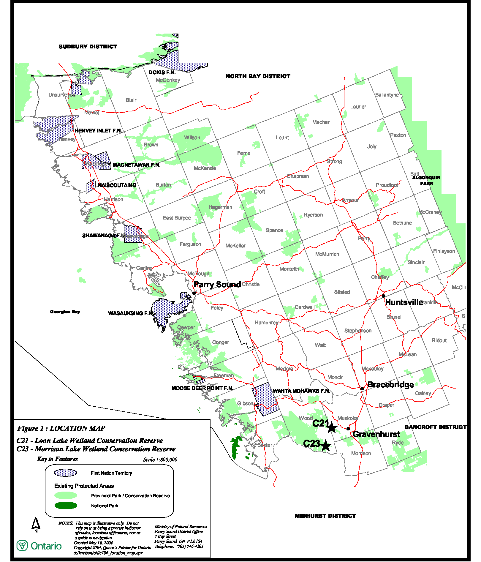
Figure 1 – Location Map (C21 and C23)

Enlarge Figure 1 – Location Map (C21 and C23)
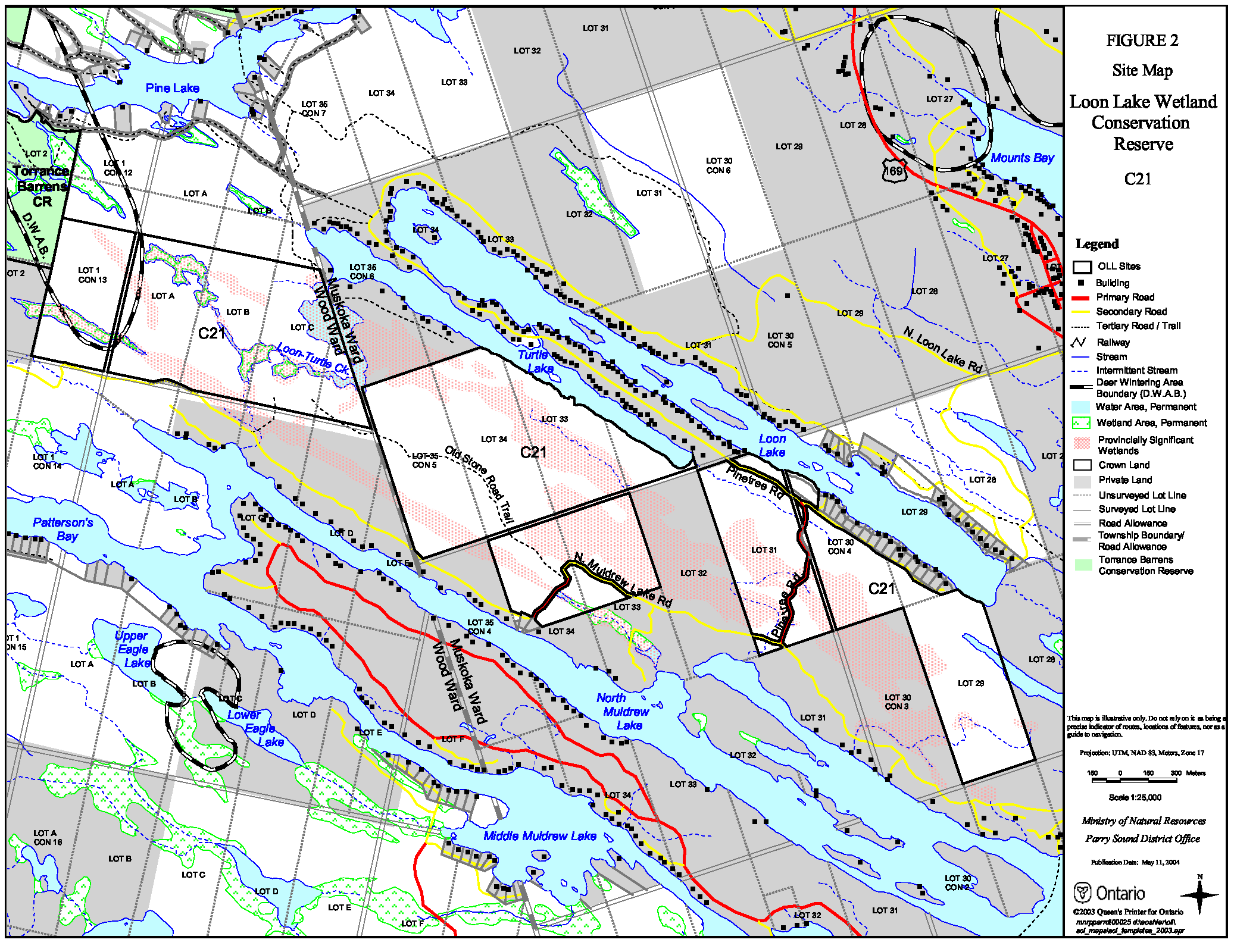
Figure 2 – Site Map Loon Lake Wetland Conservation Reserve C21
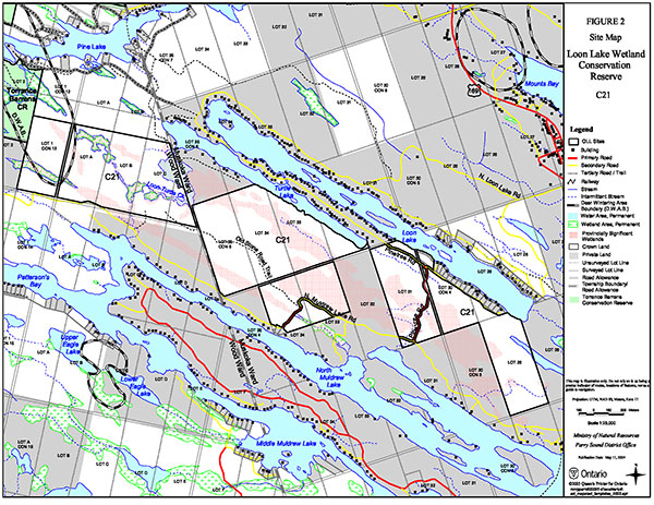
Enlarge Figure 2 – Site Map Loon Lake Wetland Conservation Reserve C21
Figure 3 – Site Map Morrison Lake Wetland Conservation Reserve C23
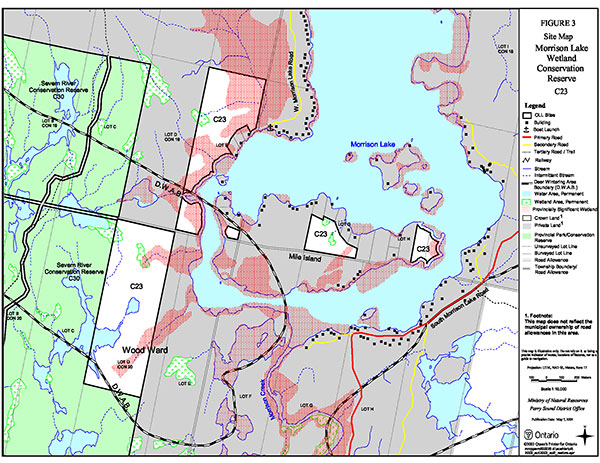
Enlarge Figure 3 – Site Map Morrison Lake Wetland Conservation Reserve C23