Manitou Mountain Conservation Reserve Management Statement
This document provides policy direction for the protection, development and management of the Manitou Mountain Conservation Reserve and its resources.
Statement of Conservation Interest
February 2005
Prepared by: Angela Anderson
Approval statement
We are pleased to approve this Statement of Conservation Interest (SCI) for the Manitou Mountain Conservation Reserve (C1527). Direction for the establishment, planning and management of conservation reserves is defined under the Public Lands Act and the Crown Land Use Policy Atlas.
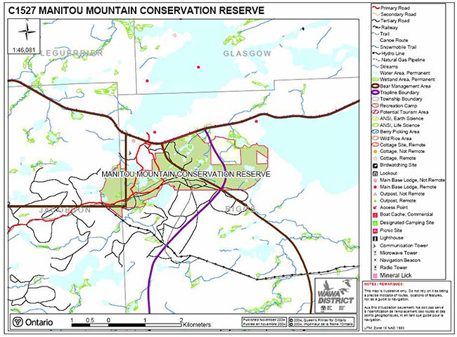
Manitou Mountain Conservation Reserve is located approximately 14 km east of the town of Dubreuilville just south of the community of Lochalsh. The conservation reserve (CR) has an area of 532 hectares and consists of hummocky, irregular topography of kettles and kames, with moraine ridges. The CR is within the Magpie Forest Management Unit in the Wawa District.
The public was invited to comment on the proposed boundary of Manitou Mountain CR in September 2000. The public will be invited to comment on this draft SCI in early 2005 Comments and concerns registered will be reflected in the final Statement of Conservation Interest. A final inspection opportunity will be provided for the public to review the approved SCI document. This document was prepared by an interdisciplinary planning team having expertise in forest ecology, biology, land management, and fire management. A draft was provided to the MNR Regional Planning Unit for review.
This Basic SCI provides guidance for the management of the Manitou Mountain Conservation Reserve and provides the basis for the ongoing monitoring of activities. More detailed direction is not anticipated at this time. Should significant facility development be considered or complex issues arise requiring additional studies, more defined management direction, or special protection measures, a more detailed Resource Management Plan will be prepared with full public consultation.
The Manitou Mountain Conservation Reserve is managed under the jurisdiction of the District Manager and the Magpie/Nagagami Area Supervisor, Wawa District, Ministry of Natural Resources.
Submitted by:
Original signed by:
Angela Anderson
Plan Author
Date: February 24, 2005
Original signed by:
Terry Taylor
District Manager Recommendation for Approval
Date: February 25, 2005
Approved by:
Original signed by:
Rob Galloway
Regional Director/Northeast Region
Date: April 10, 2005
1.0 Introduction
The purpose of this Statement of Conservation Interest (SCI) is to identify and describe the values of the Manitou Mountain Conservation Reserve. The SCI also outlines the activities that occur within the conservation reserve (CR) and provides guidelines for the management of current and future activities in the context of protecting the natural, social and cultural values of the conservation reserve. A SCI is prepared under the authority of Procedural Guideline A – Resource Management Planning (PL Procedure 3.03.05) of the Public Lands Act.
Ontario’s Living Legacy Land Use Strategy (1999) and the Crown Land Use Policy Atlas (updated 2004) outline the general land use policy and management direction for new conservation reserves. Each new conservation reserve will have a planning document, either a SCI or, in more complex situations a Resource Management Plan, that details site-specific management direction.
This Basic SCI provides guidance for the management of the Manitou Mountain Conservation Reserve and provides the basis for ongoing monitoring of activities. Although more detailed direction is not anticipated at this time, should significant facility development be considered or complex issues arise that require additional studies, more defined management direction, or special protection measures, a more detailed Resource Management Plan will be prepared with full public consultation.
Conservation reserves protect natural heritage values on public lands while permitting compatible land use activities. By allocating these lands to the parks and protected areas system through regulation, the province has ensured a certain level of permanence by distinguishing the conservation reserve and its values from the larger general use or more extensively managed landscape. In addition, the conservation reserve’s natural features are, and will be available for present and future generations to enjoy and explore.
Ontario’s Living Legacy Land Use Strategy was approved in 1999. The objectives of the Land Use Strategy are to complete Ontario’s system of protected areas; recognize the land use needs of resource-based tourism industry; provide forestry, mining and resource industries with greater certainty around land and resource use; and enhance hunting, angling and other Crown Land recreational opportunities. Manitou Mountain Conservation Reserve was created as part of the expansion of protected areas.
Manitou Mountain is a 532 hectare conservation reserve located approximately 14 kilometres east of the town of Dubreuilville. The boundary falls within the Magpie Forest Management Unit, Wawa District in the townships of Riggs, and Jacobson (Appendix 8.1). The CR is named for Manitou Mountain which is an igneous intrusion in the southeast part of the conservation reserve. The site is a unique representation of glacial events in the area. Manitou Mountain and the surrounding area have an extensive history of resource use and cultural value.
2.0 Goals and objectives
2.1 Goals of Statements of Conservation Interest
The goals of this SCI are:
- To provide background information
- To identify and describe the values of the conservation reserve
- To provide guidelines for the management of current and future activities while protecting natural, social and cultural heritage values
2.2 Objectives of Statements of Conservation Interest
The following objectives are identified as a means to achieve the above goals.
- To describe the state of the resource with respect to natural heritage values and current land use activities
- To manage the conservation reserve to protect the integrity of its natural values via specific guidelines, strategies and prescriptions
- To meet planning requirements by addressing the management intent of the conservation reserve and addressing planning and management needs
- To create a public awareness of the values within the conservation reserve and promote responsible stewardship of the protected area through partnerships with local stakeholders
- To determine long-term management goals of the conservation reserve by identifying research, client services and marketing strategies
- To identify scientific values on the site in relation to provincial benchmarks and identify the necessary monitoring and/or research to maintain the integrity of those values
- To provide direction to evaluate new uses or economic ventures through the application of a Test of Compatibility (Procedural Guideline B – Land Uses PL 3.03.05 (Appendix 8.2).
3.0 Management planning
3.1 Planning area
Conservation reserves are established by regulation under the Public lands Act. Manitou Mountain Conservation Reserve is scheduled for regulation as a conservation reserve in 2005 under authority of the Public Lands Act (O. Reg. 805/94). The planning area for this SCI is the regulated boundary of the conservation reserve and associated forest reserves (Appendix 8.1).
For purposes of Resource Management Planning for other land uses, particularly for Forest Management Planning, the boundary of the conservation reserve in itself will not be treated as a 'value'. Management prescriptions presented in this plan will relate to the activities within the conservation reserve, will identify the location, shape, size, significance and sensitivity of natural heritage values, and will identify additional special features within the boundary of the site. Management actions outside the boundary of the conservation reserve will continue to consider the site’s natural heritage features, recreational values and protection requirements within larger landscape plans such as management plans.
3.2 Management planning context
The land use intent outlined in Ontario’s Living Legacy Land Use Strategy provides context and direction to land use, resource management, and operational planning activities on Crown Land. Commitments identified in the above strategy and current legislation (PL Procedure 3.03.05) will form the basis for land use within Manitou Mountain Conservation Reserve. For up-to-date information on permitted uses, refer to the Crown Land Use Policy Atlas.
Existing permitted uses within the conservation reserve may continue, unless they are shown to have a significant negative impact on the values within the site. By regulation, this reserve cannot be used for mining, commercial forest harvest, hydroelectric power development, peat/aggregate extraction or any other industrial use. The conservation reserve has been withdrawn from the Magpie Forest Sustainable Forestry Licence (SFL) under interim protection and commercial forestry is not occurring within its boundaries. During regulation of the CR SFL notification will occur to remove the conservation reserve from the Magpie SFL and no commercial forestry will be permitted to occur in the future. Fish and wildlife management activities will generally occur in a manner similar to surrounding crown lands.
Proposed uses and development within the conservation reserve will be reviewed on a case-by-case basis. See section 6.0 and Appendix 8.3 for more details.
3.3 Planning process
The level of management planning required to fulfill protection targets is determined by the complexity of issues that need to be addressed. This SCI will only address known issues or current proposals with respect to permitted uses or potential economic opportunities brought forward during the planning process. Future proposals for development or land use will be reviewed through a Test of Compatibility.
The planning process for the Manitou Mountain Conservation Reserve involves three public consultation phases. In September 2000, notices appeared in the newspapers for the public review of the boundaries of new protected areas.
Notices will invite anyone interested to request a copy of the draft Statement of Conservation Interest during a one month review period early in 2005. Any comments, including input from previous consultation, will be considered in the finalization of this document. The SCI will also be reviewed by Ministry of Natural Resources (MNR) District and Regional staff.
The final public consultation phase will be an inspection of the MNR-approved Statement of Conservation Interest. All participants in the planning process will be notified of plan approval and can request copies of the plan to see how their comments were addressed. Following this consultation, the plan will be implemented.
Notices will not be placed on the Environmental Registry because this SCI is not considered a policy under the Environmental Bill of Rights.
4.0 Background information
4.1 Location and site description
The Manitou Mountain Conservation Reserve is situated approximately 14 km east of the town of Dubreuilville. The boundary is marked by ecological and cultural (rail line and hydro corridor) as well as vectored boundaries (Appendix 8.1). Access to the CR is available by vehicle, boat, air, and snowmobile. Location and administrative information is presented in Table 1.
Table 1: Location and Administrative Details for Manitou Mountain Conservation Reserve
| Territorial District | Algoma |
|---|---|
| OMNR Region/District | Northeast/Wawa |
| Townships | Riggs, Jacobson |
| Ecoregion/Ecodistrict (Hills, 1959; Crins, 2000) | 3E (Lake Abitibi)/3E-5 (Foleyet) |
| Regulation Date | Scheduled for 2005 |
| Total Area | 532 hectares |
| Ownership | Crown |
| UTM Coordinates | 5357888N 703615E |
| Map Number(s) | 42C/8 (Franz) |
| Nearest Town/Community | Lochalsh |
| OBM Numbers | 2016700053500 |
| Wildlife Management Unit | 32 |
| Forest Management Unit | Magpie Forest |
The Manitou Mountain Conservation Reserve contains a variety of interesting landform features including wetlands and ice-contact deposits. The conservation reserve has a low diversity and was heavily impacted by harvesting in 1994. The earth science features make the conservation reserve an attractive site to visit.
The conservation reserve is located in ecodistrict 3E-5, which is characterized by moderately broken shallow silty sand till covering bedrock knobs (Hills, 1959; Crins, 2000). The CR is located in a belt of bedrock controlled shallow stony, boulder and sandy till (Noble, 1983). The surficial geology is characterized by Bedrock-Drift Complex (Units 2ac and 2), Ice-Contact Stratified Drift Deposits (Unit 4a), Glaciolacustrine Deposits (Unit 6), and Organic Deposits (Unit 9) (Kristjansson, 2004).
The ecoregion climate within the conservation reserve is mid-humid, mid-boreal (Poser, 1992). The terrain produces a wide variety of both normal and extreme local climates. The ecoregion vegetation includes spruce, poplar, birch on fresh sites on moderately sloping terrain, white and red pine on sand ridges and white cedar in sheltered areas (Cudmore, 2004).
The conservation reserve is located in the tertiary watershed 2BD of the Lake Superior major basin (OMNR, 2002).
The conservation reserve is located in the Missinaibi-Cabonga section of the Boreal Forest Region (Rowe, 1972). The forest resource inventory (FRI) shows 10 different forest communities within the conservation reserve. The most dominant forest community is poplar hardwood mixed. The other forest communities include pure trembling aspen, jack pine conifer mixed and jack pine mixedwood. Other species occurring on the site in low numbers are cedar and supercanopy white spruce. Age variation of stands within the CR is large (10-149 years) due to man-made disturbances (1994 harvest) and stands able to withstand fire (Cudmore, 2004).
4.2 History of the site
Manitou Mountain CR was identified for its earth science values (Franz interlobate moraine) through the Ontario’s Living Legacy (OLL) Land Use Strategy (1999).
The Canadian Pacific Railway (C.P.R) tracks from Missanabie to White River were laid in 1883. The village of Hobo (later called Hobon) one mile east of Franz was established in 1883 (archives). In 1911, tracks were laid from Hawk Junction to Franz and completed in 1912, and the section from Franz to Oba was completed in 1913 (archives). Lochalsh grew considerably in 1937 due to the increase of Mining Claims in the Sault Ste. Marie Area. Approximately 200 people resided at Lochalsh and approximately 500 men were employed throughout the mines. Today the town is dependant on trapping, C.P.R. employment, the tourist trade and the hope that someone makes another gold strike (archives).
The conservation reserve is within the area used by the Missanabie Cree First Nation. The site is covered by the Nishnawbe Aski Nation (NAN) territory and Treaty #9 area. Section 5.1 Social/Economic Interest in the Area/Aboriginal Groups gives more detail on the historic use of this area by the First Nations.
In 1994, approximately 100 hectares were harvested in Manitou Mountain Conservation Reserve. There has been road development and aggregate extraction. Mineral extraction within the conservation reserve is currently unknown. There are two outpost camps operated by Hawk Air located just outside the CR in the northeast and northwest.
4.3 Inventories
Table 2 illustrates the inventories/surveys completed for Manitou Mountain CR, as well as any future requirements for earth and life sciences, cultural, recreational or other categories. The detailed Life (Cudmore, 2004), and Draft Earth Science Inventory Checklist (Kristjansson, 2004) and sections 4.1 and section 5.0 describe the key features of the CR.
Table 2: Inventory and Survey Information for Manitou Mountain Conservation Reserve
| Survey Level | Earth Science | Life Science | Cultural | Recreational |
|---|---|---|---|---|
| Reconnaissance | Kristjansson, F.J. 2004. Draft Earth Science Inventory Cheeklist. | Cudmore, W. and A. Schultz. 2004. Manitou Mountain Conservation Reserve (C1527) Life Science Checksheet – Step 4. | Missanabie Cree First Nation Traditional Ecological Knowledge Report and Missanabie Cree Native Values | Skokun N., 2004, Manitou Mountain Conservation Reserve (C1527) Recreation Resource Inventory Report. |
| Detailed | None | None | None | None |
| Requirement | Detailed field study | Comparison with current provincial landform layers to determine site significance. | Further mapping and research | Recommend monitoring |
5.0 State of the resource
This section will identify the state of the resource within, bordering or crossing the boundary of the site. The state of the resource will include the natural heritage values present within the site and those values that are adjacent to but within the CR boundary.
The state of the resource may also include natural heritage values that cross the conservation reserve’s boundary within the general use area where an artificial vectored boundary exists. Current land use activities including tenure and past and current development within the planning area will also be discussed.
5.0.1 Features represented in this Conservation Reserve
Manitou Mountain Conservation Reserve is comprised of forest lands, lake and creek systems, and wetland complexes. This site was originally identified for its earth science values through the OLL Land Use Strategy.
Manitou Mountain Conservation Reserve is underlain by bedrock geology consisting of undifferentiated metavolcanic, metasedimentary, and intrusive rocks of the Wawa Subprovince, Superior Province, Precambrian Shield (Kristjansson, 2004). The mountain is formed from an olivine-rich gabbro stock; a stock being an igneous intrusion that is less than 100 km2 in surface expression (Kristjansson, 2004).
The surface geology of the site is somewhat controversial. The conservation reserve was originally defined for a certain earth science feature; the Franz interlobate moraine. An interlobate moraine is an end moraine formed between two glacier lobes. Noble and Phillips (1988) feel that the surficial features represented in the conservation reserve are a result of the Franz interlobate moraine (in this case the Huron and Superior ice lobes) (Kristjansson, 2003). Morris (2001) of the Ontario Geological Survey found that the ice-contact landforms and sediments within the CR are representative of an esker system and not the Franz interlobate moraine (Kristjansson, 2004). Kristjansson (2004) identifies the dominant surficial geology of the conservation reserve as ice-contact stratified drift deposits (Unit 4a). These drift deposits have been classified as esker-kame-kettle complexes (which are characteristic of interlobate moraines). Remaining surficial geology of the site consists of bedrock-drift complex (Units 2ac and 2), glaciolacustrine deposits (Unit 6), and organic deposits (Unit 9) (Kristjansson, 2004).
The FRI data shows that trembling aspen hardwood mixed comprise a large portion of the forest communities in conservation reserve (Cudmore, 2004). Other forest communities include trembling aspen pure, jack pine conifer mixed and jack pine mixed wood. According to aerial reconnaissance (Burkhardt, 2003) the forest resource inventory data is reflective of the actual forest stands present in the conservation reserve. The trembling aspen pure stands have been classified as barren and scattered in the FRI and can be attributed to harvesting operations that occurred in 1994 (personal communication, Dubreauil Forestry, 2004).
Wetlands in this conservation reserve include a mixture of open muskeg, treed muskeg, open water marsh, graminoid shore fen, meadow marsh, fen float mats, cattail marsh, cedar swamp, shore fen, treed bog, low shrub shore fen, and poor fen (Cudmore, 2004). Lakes in the conservation reserve are unsurveyed; however the majority of water bodies in this area contain cool water species.
5.0.2 Quality of features represented
The quality of the representation and the current characteristics of the natural features found within the conservation reserve are as important as the overall representative features that are being protected. A number of factors are considered in the evaluation of the site, including; diversity, ecological factors, condition, special features and current land use activities.
Diversity
Diversity is a measure of the site’s life and earth science variability. It is based on the number and variety of natural landscape features and earth science values. Based on the size of the site, the number of forest units and land form features, the diversity of Manitou Mountain CR is presently considered to be low (Cudmore, 2004). Initially the diversity rating was analyzed to be high with 35 different landform/vegetation combinations. However, a large number of these combinations comprised of less than 1% of site area. When reanalyzed the diversity rating was found to be low containing 15 different landform/vegetation combinations. The most dominant combination comprises glaciolacustrine deposits with mixedwood on coarse soil (Cudmore, 2004). Values such as creeks, rivers, wetlands, kettle lakes and other lakes could add to the diversity of the conservation reserve.
Evenness is the number of communities that control the vegetative nature of the site. The Manitou Mountain Conservation Reserve is strongly skewed (> = 60%) towards pure poplar and poplar-dominated hardwood mix (42.4%), mixedwood on coarse soil (19.5%), and pure jack pine usually on coarse sand (9.5%) forest communities (Cudmore, 2004)
Ecological factors
Ecological factors are significant to the quality of representation within the reserve and include size, shape, sensitivity to potential disturbances, and current linkages to the larger landscape.
When possible, a site’s boundary should be ecologically self-contained, bounded by natural features and include adequate area around the core ecosystems (OMNR, 1992). The current boundary of the conservation reserve captures many of the landform and vegetation communities within the site. While a large portion of the conservation reserve boundary follows natural features some of the boundary follows cultural or vectored boundaries. Vectored boundaries can weaken the site’s ability to protect against adjacent land uses such as the harvesting. Consideration should be given to including more ecological boundaries to the site (Cudmore, 2004). In the north the boundary line could follow a creek to the rail line to avoid a vectored boundary. The new boundary would incorporate more cultural and biological features (Cudmore, 2004).
This conservation reserve does not meet the 2000 ha size standard necessary to protect representative landscapes and allow low intensity recreation established for natural environment parks by Ontario Parks (OMNR, 1992). Manitou Mountain Conservation Reserve therefore, may be susceptible to recreational activities (Cudmore, 2004). Future activities around the conservation reserve should be monitored carefully through sustainable management planning such as the Magpie Forest Management Plan.
Condition
Disturbance within the Manitou Mountain Conservation Reserve is ranked as high (>20% of the CR). The trembling aspen and jack pine stands in the south half of the CR were harvested in 1994 including a portion of Manitou Mountain with no planting. The areas are naturally regenerating with trembling aspen, some conifer and white birch. Land use disturbances include a secondary road (Road 909) that bisects the western section of the CR, tertiary roads running through the central portion, a transmission line on the southwest boundary, and a rail line defining the northern boundary. There is also a snowmobile trail in the southwest portion of the conservation reserve, one inactive aggregate pit (AP#15674), and a camp in the southwest (Gamble, 2003). Natural disturbance includes a fire that encompassed the CR (1923), damage from a spruce budworm infestation, and windthrow (Cudmore, 2004).
Special features
There are no known significant wildlife features or habitat for vulnerable, threatened, or endangered (VTE) species in the conservation reserve. The sheer rock face along Burns Lake, the kettle lakes, and Manitou Mountain are unique features of this conservation reserve. Manitou Mountain is a 3000 year old archaeological site, a sacred place, and a site for spiritual ceremonies (Cudmore, 2004). The Missanabie Cree are concerned about the protection of this mountain so they can continue to gain value from it in the future. The Missanabie Cree have not mapped the area precisely, however, the majority of or the entire site is on sacred and historical ground (Cudmore, 2004). Other points of interest are the dominant old growth forest communities, and the number of ecological boundaries (shorelines) that define the conservation reserve (Cudmore, 2004).
Current land use activities
Current land use activities in this conservation reserve are extensive because of the accessibility in the west portion of the reserve. Activities include, trapping, fishing, hunting, snowmobiling, boating and travelling by various means on the tertiary and secondary roads. There is no record of campsites, portages, hiking trails, or ATV trails although they are likely present. The condition of tertiary roads in the site is also unknown. The area is also used by the Missanabie Cree First Nation for various purposes currently and traditionally.
5.1 Social/Economic Interest in the area
Linkage to local communities
This conservation reserve, as well as the surrounding area, contributes to the local community by providing an ecosystem that supports the production of wildlife and fish. Local trappers, hunters and fishers who harvest within the site indirectly benefit the local community’s economy. Other recreationalists such as snowmobilers and other travelers would also contribute to the local economy.
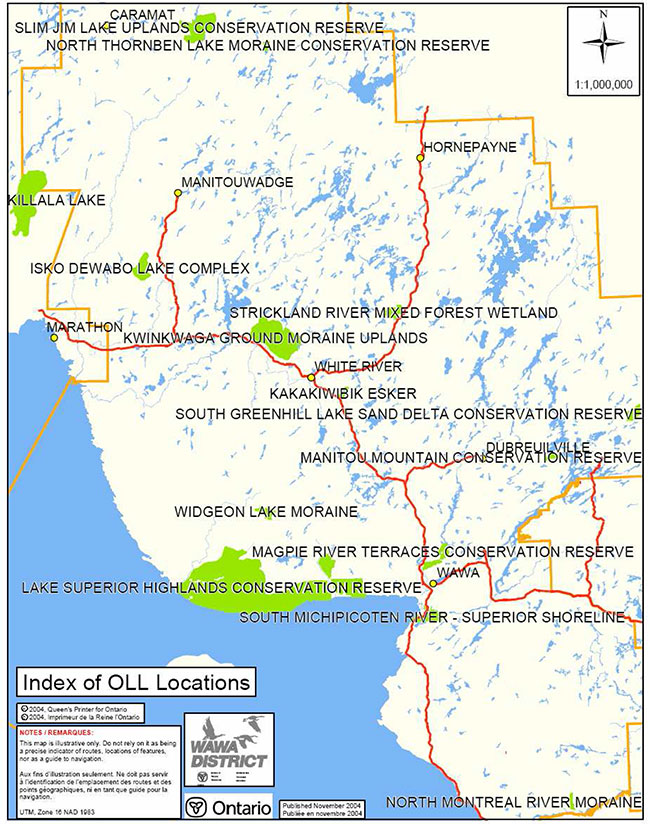
Manitou Mountain Conservation Reserve is located in close proximity to the Chapleau Crown Game Preserve and South Greenhill Lake Sand Delta Conservation Reserve. Future opportunities to link the recreational value of these areas may also contribute to the local communities.
Heritage estate contributions
Manitou Mountain CR contributes to the province’s parks and protected areas by preserving a number of natural heritage values mentioned in the previous section (5.0). The reduction/elimination of new industrial disturbance and land use in the CR will help to ensure that fragile vegetation communities, significant geological features and waters are protected into the future.
Aboriginal groups
The conservation reserve is within the area traditionally used by the Missanabie Cree First Nation. The Missanabie Cree First Nation is part of the Treaty #9 area of Northern Ontario. The First Nation belongs to the political union of fifty-two First Nations under the NAN. The Missanabie Cree First Nation is currently without a reserve and has been actively involved in the land claim process with both the federal and provincial governments.
The ancestors of the Missanabie Cree First Nation once settled in the Missanabie area as well as surrounding areas including Lochalsh and Franz. The area was used to trap, hunt, fish, pick berries, gather medicines and also harvest timber to heat and build their homes. The Missanabie Cree have identified areas such as Manitou Mountain that are considered sacred to them. Manitou Mountain is a site of spiritual ceremonies that is still visited by Elders and other members of the First Nation.
Members of the Missanabie Cree held trap lines in Riggs and Jacobson townships to trap, trade and sell the fur to obtain money and goods. Band members still hold trap line areas within the conservation reserve (WA-46 and WA-45).
Areas in and around Dog Lake have been used extensively and a large portion of that use has been documented through a Traditional Ecological Knowledge Report. Ohio Point on Dog Lake shows evidence of a 4000 year old Indian Village adjacent to Manitou Mountain. A concentration of stone tools, spears and scraping tools have been found in the area (Nolan, undated). A small prehistoric campsite was found on Lovers Beach directly across from Manitou Mountain. The cove adjacent to the beach provided good fishing in the past as it does today (Nolan, undated). Dog River is utilized to gain access to other inland lakes for fishing, hunting and trapping. This area was also utilized for growing vegetables as the soil in Missanabie was unsuitable (Nolan, undated).
Mining industry and Ministry of Northern Development and Mines
According to the 1998 MNR Protected Areas Summary Report (C15), mineral resource assessment in 78.9% of the site was unknown or low and 20.3% was very high. The Manitou Mountain Conservation contains bedrock units with high mineral potential (Srivastava, 1978).
This conservation reserve contains 6 mining claims (which have been designated as forest reserves) and no leases (MNDM, 2004).
A forest reserve is a land use designation applied to areas that were initially identified for inclusion in the CR but where subsequent detailed examination determined that there were existing mining claims or leases.
Mining and surface rights have been withdrawn from staking within the conservation reserve boundaries under the Mining Act (RSO 1990 Chapter M.14). Therefore, no new claims can be staked within the CR boundary. The intent is that forest reserve areas will be added to the conservation reserve if a claim or lease is retired through normal process.
Policies for forest reserves are similar to the policies for new conservation reserves, except that mining and related access will be allowed in a forest reserve.
5.2 Natural Heritage Stewardship (vegetative/plant community management and earth science value protection)
The life science targets achieved by the creation of this site are of regional or local significance since representation is also found in the Kakakawibik Esker Conservation Reserve (C1518) (Cudmore, 2004). Noble (1998) considers the ice-contact landforms and deposits contained within the Manitou Mountain Conservation Reserve to be of provincial significance. This evaluation is based on the assumption that the end moraine identified by Boissonneau (1965, and 1966) in the Franz area is also an interlobate moraine (i.e., the Franz interlobate moraine).
Tom Morris completed a regional-scale, field investigation of the glacial and post glacial geology of the Wawa area (includes the Manitou Mountain Conservation Reserve) for the Ministry of Northern Development and Mines (Morris, 2001). Morris considers the ice-contact landforms and deposits contained within the conservation reserve to be representative of an ordinary esker system, not an interlobate moraine (Kristjansson, 2004).
A detailed field study of the nature, origin, and significance of the ice-contact landforms contained within the conservation reserve is required. In the meantime, the earth science features of Manitou Mountain Conservation Reserve will be considered provincially significant (Kristjansson, 2004).
There is no present monitoring or research program being conducted in conjunction with this conservation reserve.
Current fire management is concurrent with that practiced on adjacent crown land. Management strategies are described in section 6.2 State of the Resource Management Strategies. Insect damage to balsam fir trees by the spruce budworm has been recognized in the conservation reserve (Cudmore, 2003). No management plan has currently been initiated to control damage caused by these pests.
Continued monitoring or further studies on lakes or rivers in the conservation reserve have not been identified.
5.3 Fisheries and wildlife
Manitou Mountain Conservation Reserve is home to large wildlife species such as black bear and moose. According to Micah Plourde, Wawa District Conservation Officer, (personal communication, 2004) the vicinity of Manitou Mountain is an active moose hunting area. The conservation reserve is also inhabited by a number of small game species such as lynx, snowshoe hare, beaver, mink, marten, fisher, muskrat, weasel, fox and otter. The CR has not been designated as a core pine marten area in the Magpie Forest Management Plan. Inventories have not been conducted to verify the other wildlife species that may utilize this site.
Several lake surveys have been conducted on Dog Lake, the most recent being a Summer Profundal Index Netting (SPIN) in 2002. Species captured include lake trout, lake whitefish, lake herring, northern pike, white sucker, burbot, yellow perch, and walleye. Other species collected during previous studies on Dog Lake include blacknose shiner, and smallmouth bass. Other lakes in the conservation reserve have not been surveyed. During aerial reconnaissance a canoe was noted stashed at a small lake south of Rock Lake (Gamble, 2003) which suggests there may be fishing opportunities there. Lake surveys done on Wabatongushi Lake indicate that species consist of lake whitefish, lake herring, northern pike, white sucker, spottail shiner, burbot, yellow perch, and walleye. Since lakes in the conservation reserve drain into Wabatongushi Lake, it would be reasonable to assume other lakes within the CR contain similar species.
There have been no recent inventories performed for vulnerable, threatened and endangered (VTE) species at risk. There are no known VTE species or habitats within the conservation reserve. Additional studies and subsequent development of protection/restoration plans would be conducted if warranted.
5.4 Cultural Heritage Stewardship
There has been some research on the cultural values within the conservation reserve. The Gap Analysis identified Manitou Mountain as a 3000 year old archaeological site, a sacred place, and a site for spiritual ceremonies. A Native Background Information Report was done for the Magpie Forest Management Plan and identified this area as being used by the ancestors of the Missanabie Cree First Nation for logging, hunting, fishing, gathering, trapping and spiritual and cultural reasons. Information has also been gathered from Missanabie Cree Elders in the form of the Missanabie Cree First Nation Traditional Ecological Knowledge Report prepared by Archie Nolan.
There are no other known cultural values in the conservation reserve at this time.
5.5 Land use/current or past development
As described in previous sections, past land use has been high in the west part of the conservation reserve. Within the Forest Reserve portion of the CR there are 6 mining claims with no leases. There are no known potential mining hazard areas such as old shafts in these areas. The extraction of minerals from areas in the conservation reserve is not known at this time.
There are many roads within and across the conservation reserve boundary. There is only one road that has a land use permit associated with it and that is road 909. A snowmobile trail crosses the boundary of the conservation reserve and through the southwest portion but requires no land use permit. The transmission line on the southwest border of the conservation reserve has a land use permit.
There is an aggregate pit (AP# 15674) at the southwest end of Teacher Lake that has not yet been officially turned back over to the crown. The pit was used by Dubreuil Forest Products Ltd. and has no record of aggregate extraction since its supposed expiry January 3, 1996. The original aggregate permit requested extraction of 5000 tonnes of sand and gravel.
5.6 Commercial use
Manitou Mountain CR is within two active baitfish areas (WA-72 and WA-73), two active trapline areas (WA-46 and WA-45), and three active bear management areas (WA-32-008, WA-32-006 and WA-32-005). It is unknown what proportions of returns come from within the boundaries of the conservation reserve as information on returns is only available for entire areas. Trapline returns may include species such as beaver, mink, marten, otter, fisher, lynx, muskrat, weasel and fox (Skokun, 2004).
There is no other known commercial use associated with this area.
5.7 Tourism/recreation use/opportunities
Tourism and/or recreational opportunities in this conservation reserve have a high potential because it is very accessible. The CR is currently used for fishing, hunting, trapping and snowmobiling. There is potential for further tourism/recreation use to develop in the future. Hiking, snowshoe, ski, and mountain bike trails could potentially be developed in the future and camp sites could be cleared to allow for back country camping experiences. ATV trails could be developed on the tertiary roads. These activities would have to be proven not to decrease the value of the remote tourism opportunities currently existing and they would pass a Test of Compatibility.
There are no current proposals submitted for recreational development.
5.8 Client services
No infrastructure or interpretive facilities are proposed for the site. Informal wildlife viewing and nature appreciation can continue without further development.
6.0 Management guidelines
6.1 Management planning strategies
The land use intent outlined in Ontario’s Living Legacy Land Use Strategy and the Crown Land Use Policy Atlas provides context and direction to land use, resource management, and operational planning activities on Crown Land. Commitments identified in the above strategy and current legislation (PL Procedure 3.03.05) will form the basis for land use within Manitou Mountain Conservation Reserve. For up-to-date information on permitted uses refer to the Crown Land Use Policy Atlas. See Appendix 8.3 for a summary of permitted uses in Manitou Mountain Conservation Reserve.
Existing permitted uses within the conservation reserve may continue, unless they are shown to have a significant negative impact on the values within the site.
Proposed uses and development within the conservation reserve will be reviewed on a case-by-case basis. A Test of Compatibility (Appendix 8.2) must be passed before they are deemed acceptable. The emphasis will be on ensuring that the natural values of the conservation reserve are not negatively affected by current or future land use activities. Therefore, any application for new specific uses will be carefully studied and reviewed. The Ministry of Natural Resources, partner organizations and/or proponents may undertake such studies. Applicable environmental assessment requirements will also be met according to A Class Environmental Assessment for MNR Resource Stewardship and Facility Development Projects (upon its approval, A Class Environmental Assessment for Provincial Parks and Conservation Reserves will apply). Authorization for potential compatible uses will be in the form of a Land Use Permit or a Licence of Occupation.
6.2 State of the resource management strategies
Natural Heritage Stewardship – Vegetative/plant community management and earth science value protection.
This conservation reserve will be managed by allowing vegetative communities to develop while existing traditional and recreational uses continue. Monitoring of sensitive wetland complexes may be necessary depending on the degree of recreational use.
The MNR recognizes fire as an essential process fundamental to the ecological integrity of conservation reserves. In accordance with existing Conservation Reserve Policy and the Forest Fire Management Strategy for Ontario, forest fire protection will be carried out as on surrounding lands.
Whenever feasible, the MNR fire program will endeavor to use "light on the land" techniques, which do not unduly disturb the landscape, in this conservation reserve. Examples of light on the land techniques may include limiting the use of heavy equipment or limiting the number of trees felled during fire response efforts.
Opportunities for prescribed burning to achieve ecological or resource management objectives may be considered. These management objectives will be developed with public consultation prior to any prescribed burning, and reflected in the document that provides management direction for this conservation reserve. Plans for any prescribed burning will be developed in accordance with the MNR Prescribed Burn Planning Manual (OMNR, 1997), and the Environmental Assessment Act (R.S.O. 1990, Chapter E.18).
Personal use permits for wood harvesting are not permitted. Salvage of standing, fallen, or sunken dead trees will not be permitted, except when authorized in conjunction with approved maintenance activities.
The collection/removal of vegetation and parts thereof (including Taxus Canadensis) will not be permitted with the exception of treaty and aboriginal rights. However, subject to a Test of Compatibility (Appendix 8.2), the Area Supervisor may authorize the collection of plants and/or parts for the purposes of research or scientific study within the reserve if required.
Forest renewal by artificial means will not be appropriate for a natural area. Similarly control of native pests will not be permitted. Programs may be developed to control invasive non-native forest insects and diseases in the conservation reserve where these threaten significant values in or adjacent to the site. Where insects or disease threaten significant values, in or adjacent to the site, control will be directed as narrowly as possible to the specific insect or disease. Biological control will be used whenever possible. If this circumstance should arise the control method would undergo a Test of Compatibility (Appendix 8.2).
All earth and life science features will be protected by defining compatible uses, enforcement direction through applicable legislation, and monitoring and mitigating issues. Industrial activities such as; timber harvesting, prospecting, mining, and new hydro generation will not be permitted within the boundaries of the conservation reserve. Energy transmission, communication and transportation corridors or resource roads or construction of facilities are discouraged, through existing planning process. Exceptions based on a Test of Compatibility (Appendix 8.2) may be made for minor structures.
Ontario Ministry of Natural Resources will provide leadership and direction for maintaining the integrity of this site as a natural heritage estate. Research, protection, education and understanding and interpretation of the natural heritage features of the site will be encouraged and fostered through local and regional natural heritage programs and initiatives.
Fisheries and wildlife
Fish and wildlife resources will continue to be managed in accordance with policies and regulations prevailing in the area and under the direction of the Magpie/Nagagami Area Supervisor. Provincial legislation and policy will dictate management and enforcement objectives for this area.
Existing hunting and sport fishing by outfitters' clients and the general public will be permitted. No new commercial outfitting, outpost, hunting camps or new trap cabins will be permitted within the boundaries of the conservation reserve. The introduction of exotic and/or invasive species will not be permitted.
Cultural heritage
Should the MNR consider new structural development, significant clearing of vegetation or altering of land within this conservation reserve, the MNR will adhere to the cultural heritage resource screening process as is identified in its Memorandum of Understanding (MOU) with the Ministry of Culture (MCL). While the purpose of this MOU is to provide a process to identify and protect cultural heritage resources when the MNR is reviewing work permits or disposing of Crown rights under the authority of the Public Lands Act, the considerations and criteria would also enable the MNR to identify high potential cultural heritage areas for other purposes within conservation reserves. If the screening process indicates that the site of a proposed activity is within an area of high cultural heritage potential, the MNR will consult with the MCL to determine the appropriate cultural heritage assessment requirements and will ensure a preliminary archaeological assessment if appropriate.
All aboriginal and treaty rights will continue to be respected and are not affected by the establishment of this conservation reserve.
Any future proposals or decisions that have potential impact(s) on the individual or aboriginal or community values will involve additional consultation with the affected aboriginal groups.
Social/economic
Under the Ontario Living Legacy Land Use Strategy, mining and related access will be allowed in a forest reserve (FR). For those activities that could negatively influence the natural heritage values within the FR and/or the CR, the district will work with the proponent to identify and mitigate potential mining or natural heritage concerns.
Mining will not occur in any portion of the regulated conservation reserve boundary.
Land use/past and existing development
Conservation reserve regulations do not permit mining, commercial forest harvesting, hydroelectric power development, the extraction of aggregate and peat or other industrial uses (Public Lands Act, Ontario Regulation 805/94).
The sale of Crown Lands within the conservation reserve is not permitted.
New recreation camps will not be permitted however; existing recreation camps will be permitted to continue. Existing camps may be eligible for "enhanced" tenure, but are not eligible for purchase of land. There are two forms of enhanced tenure that may be considered:
- Upgrade in the nature or type of tenure (e.g. from Land Use Permit to a lease); and/or
- An extension in the term of the tenure (e.g. from 1 year to 10 years)
Applications for enhanced tenure will be approved if determined acceptable using a screening criteria. A change in tenure does not convey a commitment to provide for, or agree to, a change in the type or the standard of existing access to the recreation camp.
Unauthorized occupations of lands within the conservation reserve will be handled in accordance with approved policy, and any required structural removal will be at the owner’s expense.
New roads for resource extraction and/or private use will not be permitted, nor will additions to existing roads or upgrading of existing private roads be permitted.
New trails are not encouraged, however they may be considered when compatible with other recreational uses and the maintenance of environmental integrity. Any new trail development must go through a Test of Compatibility (Appendix 8.3) to ensure the quality of the life and earth science representation and any additional values (e.g. aesthetics, landscape views, sensitive areas, and remote tourism) are maintained.
Use of existing authorized ATV and snowmobile trails will be permitted to continue as long as they do not impair the natural features and values for which the area is identified and there are no significant environmental impacts. Consideration for new ATV and snowmobile trails will occur on a case-by-case basis. Public consultation will be an important part of the process. Non-trail snowmobile and ATV use will be permitted only for the direct retrieval of game and/or bait.
The use of existing unauthorized trails will be monitored to ensure that conservation reserve values are not being adversely impacted. Depending on the results of the monitoring, some of the unauthorized trails may need to be redirected from sensitive areas or eliminated completely.
The district may sometime in the future consider developing a trails strategy to ensure the values within the conservation reserve are fully protected while allowing current permitted uses to occur.
Facility infrastructure and development for recreation may be considered in the future if there is a demonstrated need for such facilities. A more detailed management plan would be required prior to construction.
Commercial use
Existing non-industrial commercial uses such as trapping and baitfish harvesting will be permitted to continue. Renewals and transfers will also be permitted. These activities will continue to be monitored in order to ensure they do not deplete natural resources and that they impose a minimal impact on the features identified for protection.
New non-industrial commercial activities (e.g. trapping and bait fishing) which overlap with the conservation reserve may be considered subject to a Test of Compatibility, consistent with provincial direction. Any new trails associated with the new non-industrial commercial activities must also be considered subject to a Test of Compatibility.
Existing commercial bear hunting operations are permitted to continue but the introduction of new operations will not be allowed. Lapsed BMA's will not be reactivated, and transfer requests will be dealt with on a case-by-case basis.
Commercial wild rice harvesting will not be permitted. Other commercial food collection will also be prohibited; particularly mechanical blueberry harvesting methods that can damage plants and deplete the crop available for recreational pickers.
Tourism/recreation
Tourism proposals will be assessed on a case-by-case basis and approved if compatible with natural values and other uses that may exist at the time.
Blueberry picking and other food gathering will continue to be permitted on a recreational basis.
Client services
The focus will remain on low key information and self-interpretation of conservation reserve features. Messages should focus on the area’s natural heritage features, recreation opportunities, nature appreciation and education.
At the present time there are no plans for structural development within this conservation reserve.
6.3 Specific feature/area/zone management strategies
Special features in the conservation reserve may require more detailed management strategies to help them endure into the future. The Manitou Mountain 3000 year old archaeological site, sacred place, and a site for spiritual ceremonies should be protected from high recreational use. With recreational use there is potential for looting of artefacts, vandalism and disruption of aboriginal values. An area set aside for no motorized vehicles could be considered and negotiated with various stakeholders. Specific mapping of the cultural site should take place in order to better protect its value.
Landforms in the CR may be harmed by use of ATV's especially where there is a sloping topography such as Manitou Mountain. ATV use can cause damage to the vegetation cover as well as increase erosion; noise from these vehicles can also disrupt local inhabitants. Wetlands are sensitive to motorized travel especially those located near the secondary road 909. As the conservation reserve is easily accessible to trappers, hunters and anglers, fish and wildlife populations have the potential to become over-exploited if not properly managed.
The Manitou Mountain CR has not been delineated into zones for management of a specific resource. Zoning of the CR for management of special features will require an amendment to this SCI. Research in the CR will be encouraged, and some research activities could conceivably require special conditions such as elimination of noise or restrictions on harvesting of wildlife.
6.4 Monitoring, assessment and research
Further analysis and classification of the vegetative communities and landform layers to determine the site’s significance and contribution to the parks and protected areas program should be considered in any future assessment of the conservation reserve. The state of the CRs resources should be monitored to report on changes such as natural disturbances, human disturbances, and management prescriptions within and adjacent to the conservation reserve (Cudmore, 2004).
Further review is recommended for the inventory and monitoring of life and earth science, and recreational features within the conservation reserve.
It is also recommended that further research be put into identifying and researching historical and cultural significance of the site including aboriginal use.
Consideration will be given to inventory and documentation of natural and cultural values, and the assessment of use/activity impacts. All research will be carried out in a non-destructive manner. Research proposals must follow Procedural Guideline C – Research Activities in Conservation Reserves (PL 3.03.05).
Research projects have taken place on Dog Lake in the past. Projects include: genetic sampling of walleye, lake trout spawning investigation, fish tagging study, contaminant monitoring, and fish aging analysis.
Research, education and interpretation will be encouraged to provide a better understanding of the management and protection of the natural heritage values and will be fostered through local and regional natural heritage programs, initiatives and partnerships.
6.5 Implementation and plan review strategies
Management of the CR will be done largely using a "hands-off" approach. For the short term, the forest community will develop, and low impact activities described in the plan will continue. Emphasis will be placed on awareness information highlighting conservation reserve values and appropriate uses.
Priorities will include:
- Maintaining the quality of earth science and cultural representation features such as Manitou Mountain, while providing for the needs of recreation and other users
- Monitoring impacts of existing recreation use on the conservation reserve to ensure adherence to the management guideline and mitigating any negative effects
- Working with adjacent SFL holders and stakeholders to protect important values that may be disturbed as a result of the vectored boundaries
Manitou Mountain Conservation Reserve SCI will be reviewed on an ongoing basis as there is no formal review or expiry date for the document. This SCI will be amended through a standard process of minor and major amendments. Minor amendments will be processed in a relatively informal manner and will require the approval of the Magpie/Nagagami Area Supervisor. These amendments will deal with uses and activities that do not affect any of the policies in this SCI (e.g. new uses and/or activities that are consistent with existing permitted uses).
Uses and/or activities that were not anticipated in the approved SCI and which may have an impact on the values of the conservation reserve will require a major amendment. In assessing major changes, the need for a more detailed Resource Management Plan will first be considered. This will include an opportunity for public comment and input and will require the approval of the Wawa District Manager and the Regional Director.
This SCI or future RMP, if required, plus the Crown Land Use Policy Atlas and associated website will be amended to reflect any changes in management direction.
6.6 Marketing strategies
The site will be more generally promoted as part of the Parks and Protected Areas initiative, and at the current time information on the Manitou Mountain CR is available worldwide on the Crown Land Use Policy Atlas website.
Marketing activities will be kept to a minimum and there are no plans to actively promote the area for research or commercial purposes such as tourism at this time. If marketing should take place in the future, it may be done in conjunction with the Chapleau Crown Game Preserve, South Greenhill Lake Sand Delta, or Missinaibi Lake Provincial Park.
7.0 References
Boissonneau, A.N., 1965. MapS365, Algoma-Cochrane, Surficial Geology; Cartography by the Lands and Surveys Branch, Ontario Department of Lands and Forests.
Boissonneau, A.N., 1966. Glacial History of Northeastern Ontario: I The Cochrane-Hearst Area; Canadian Journal of Earth Sciences, Volume 3, No. 5, p. 559 – 578.
Burkhardt, B. 2003. C1527 Aerial Reconnaissance Survey Field Notes.
Crins, W.J. 2000. Ecoregions of Ontario: Modifications to Angus Hill’s Site Regions and Site Districts – Revisions and Rationale.
Cudmore, W. and A. Schultz. 2004. Manitou Mountain Conservation Reserve (C1527) Life Science Checksheet – Step 4.
Gamble, P. 2003. Aerial Reconnaissance Field Notes.
Hills, G. 1959. A ready reference to the description of the land of Ontario and its productivity.
Kristjansson, F.J. 2003. Draft Memorandum Re: Earth Science Values within Manitou Mountain Conservation Reserve (Franz Interlobate Moraine or Esker System).
Kristjansson, F.J. 2004. Draft Earth Science Inventory Checklist Manitou Mountain (C1527 and F1527).
Ministry of Northern Development and Mines (MNDM). 2004. Mining Lands – Mining Claims Summary. www.mci.mndm.gov.on.ca/Claims/ (Link no longer active)
Morris, T.F. 2001. quaternary Geology, Franz-Manitowik Lake-Kinniwabi Lake Area, Ontario Geological Survey, Map 2573, Scale 1:50,000.
Noble T.W. 1998. Earth Science Theme Study of Glacial and Contemporary Landforms of the Eastern Lake Superior, Northern Lake Huron and Temiskaming Basins: Reconnaissance Survey of Candidate Earth Science Sites; Ontario Ministry of Natural Resources, 22 p.
Noble, T.W. 1983. Central Boreal Forest Region (3E). Life Science Report Northeastern Region. Internal Report.
Noble, T.W., and B.A.M. Phillips, 1988. Earth Science Theme Study, Glacial and Contemporary Landforms, Phase I: Pre-Field; Terry Noble – Landform/Vegetation Inventory and Analysis; Ontario Ministry of Natural Resources, Open File Earth Science Report 8807, 55 p.
Nolan, A. Undated. Missanabie Cree First Nation Traditional Ecological Knowledge Report.
Ontario Ministry of Natural Resources (OMNR). 2002. MNR districts and major basins of Ontario.
Ontario Ministry of Natural Resources (OMNR). 1992. Ontario Provincial Parks: Planning and Management Policies, 1992 Update.
Ontario Ministry of Natural Resources (OMNR). 1997. MNR Prescribed Burn Planning Manual
Ontario Ministry of Natural Resources. 2004. Forest Management plan for the Magpie Forest for the Twenty Year Period from 2004-2024 First Information Centre Supplementary Documentation Native Background Information Report and Appendix: Missanabie Cree Native Values.
Poser, S. 1992. Report on the Status of Provincial Parks in the Site regions and Districts of Ontario.
Rowe, J.S. 1972. Forest Regions of Canada.
Skokun, N. 2004. Manitou Mountain Conservation Reserve (C1527) Recreation Resource Inventory Report.
Stivastava, P., and G. Bennett, 1978. Geology of Rigs and West Townships, District of Algoma; Ontario Geological Survey, Report 174, 56 p.
8.0 Appendices
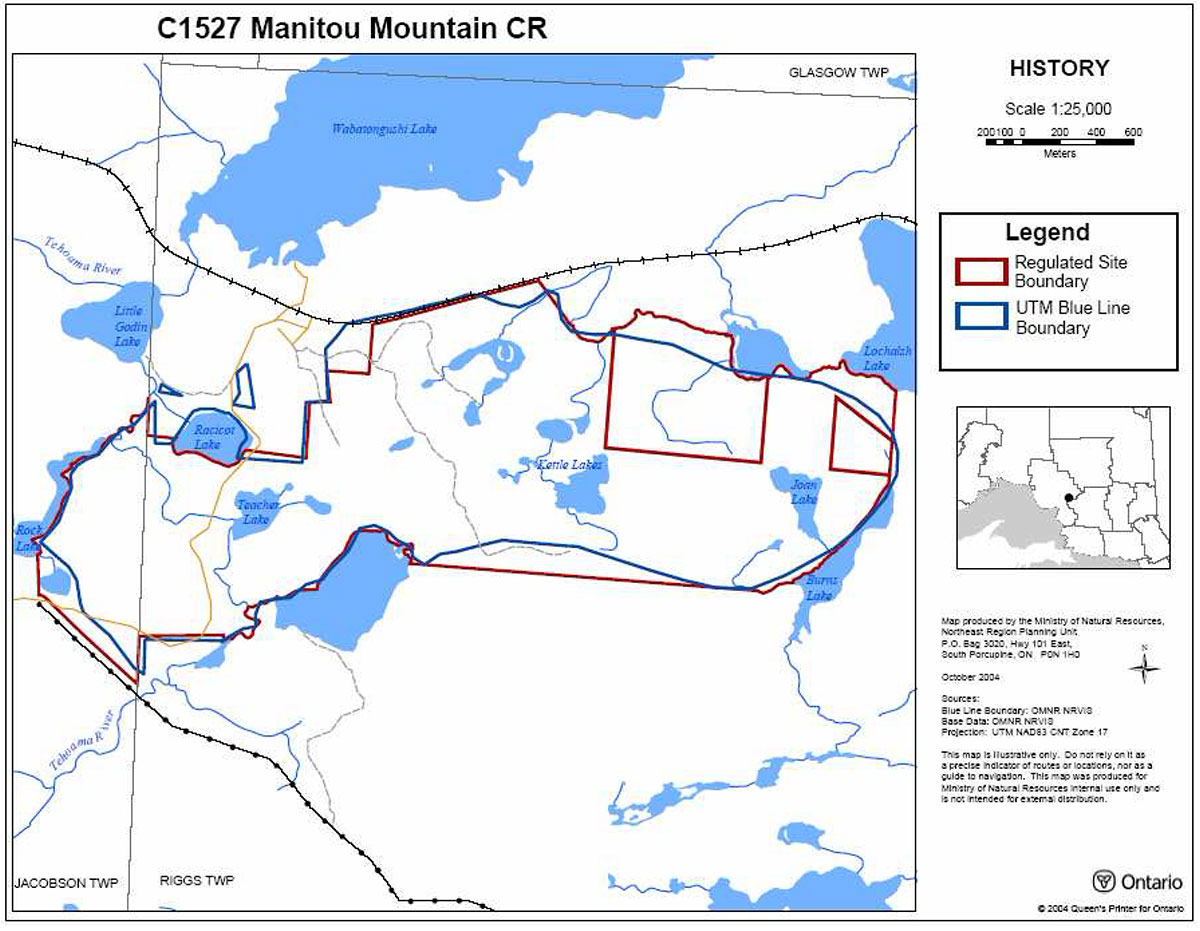
8.1 Maps
8.1.1 Recreation inventory map
Enlarge 8.1.1 Recreation inventory map
8.1.2 Site location map
Enlarge 8.1.2 Site location map
8.1.3.Boundary map

8.2 Procedural guideline B – land uses – Test of Compatibility
(PL Procedure 3.03.05)
The Conservation Reserve policy provides broad direction with regard to the permitted uses. The policy provides only an indication of the variety of uses that will be considered acceptable in conservation reserves. The only caution is that "any new uses, and commercial activities associated with them, will be considered on a case by case basis, and, they must pass a test of compatibility to be acceptable." What does a 'test of compatibility' mean?
An examination of this must start from the premise of why an area is set aside – specifically, its representative natural heritage values. Criteria are then identified to guide compatibility considerations. These criteria apply to the long-term acceptability of both existing uses and new uses.
-
Conformity to SCI/RMP: SCI describe values for which an area has been set aside and the range of appropriate uses that will be permitted in the area. SCI may also speak to the acceptability of other 'new' uses currently not occurring in the area.
The first 'test' is: "do proposed new land uses and/or commercial activities conform to the direction of the SCI/RMP for the conservation reserve? Would the new use(s) depart from the spirit of appropriate indicator land uses in the SCI/RMP?"
- Impact Assessment: If the proposed use(s) pass test 1 it is important to determine their impact on the area before they are approved. This should include the following:
- Impact on natural heritage values: "will the new use(s) impact historical or archaeological values in the area?"
- Impact on research activities: "will the new use(s) affect research activities in the area?"
- Impact on current uses: "will the new use(s) have any negative impact on the array of current uses?"
- Impact on area administration: "will the new use(s) increase administrative costs and/or complexity?" (For example, the cost of area monitoring, security and enforcement.)
- Impact on accommodating the use outside the conservation reserve: "could the use(s) be accommodated as well or better outside the conservation reserve?"
- Impact on socio-economics of the area: "will the new use(s) affect the community(ies) surrounding the area in a positive or negative way?" (For example, will the new use make an area less remote thereby affecting a local tourism industry that is dependent on the area’s remoteness for its appeal?)
- Impact on area accessibility: "does the new use(s) give someone exclusive rights to the area or a portion of the area to the exclusion of other existing uses?"
8.3 Summary of permitted land and resource uses
| Use | Permitted New | Permitted Existing |
|---|---|---|
| Commercial timber harvest, commercial hydro development | No | No |
| Mineral exploration and mining | No | No |
| Bait fishing | Maybe | Yes |
| Commercial fur harvesting | Maybe | Yes |
| Sport hunting | Yes | Yes |
| Sport fishing | Yes | Yes |
| Seasonal recreation camps | No | Yes |
| Commercial bear hunting | No | No |
| Tourism Facilities (for resource based tourism) and recreational trails | Maybe | Yes |
| Land Disposition | No | Yes |
| Roads | No | Yes |
| Energy Transmission and Communications Corridors | No | Yes |
| Commercial Food Harvesting | No | No |
| ATV and Snowmobile use on trails | Maybe | Yes |