McLaren Forest Conservation Reserve Management Statement
This document provides policy direction for the protection, development and management of the McLaren Forest Conservation Reserve and its resources.
(C159)
Statement of Conservation Interest
Ontario Ministry of Natural Resources
North Bay District
March 2005
Approval statement
We are pleased to approve this Statement of Conservation Interest for the McLaren Forest Conservation Reserve (C159).
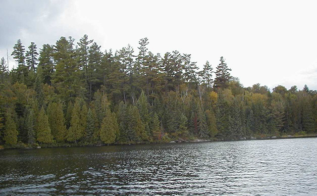
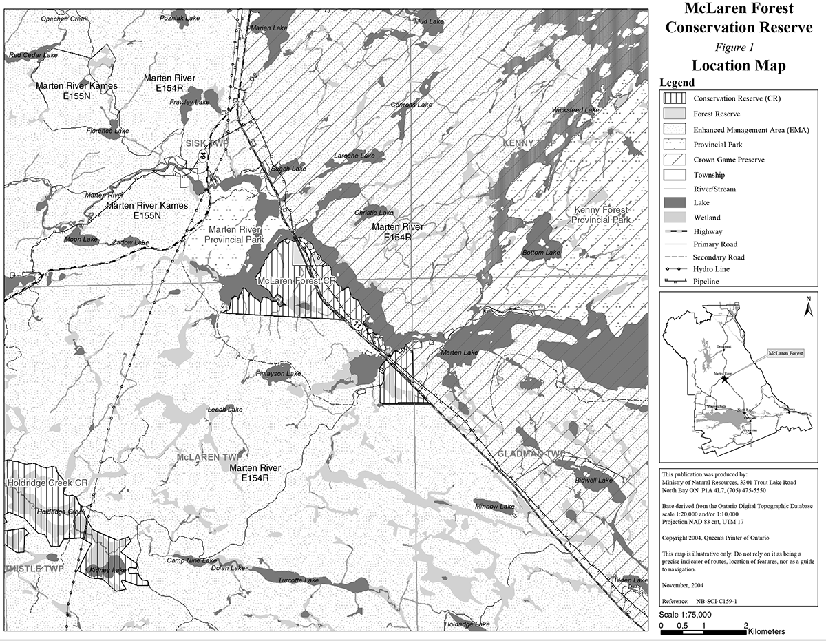
McLaren Forest Conservation Reserve is a 410 hectare site, 439 hectare site with forest reserves, located in Ecodistrict 5E-6 approximately 50 km south of Temagami along Highway 11 (figure 1). The boundary of the conservation reserve is located in the geographic townships of McLaren, Sisk and Gladman within the Corporation of the Municipality of Temagami in the District of Nipissing (figure 2). The eastern sections of the conservation reserve are within Nipissing Crown Game Preserve. The whole area is included within the Marten River Enhanced Management Area (E154r). McLaren Forest Conservation Reserve is bordered by Crown land, Marten Lake and the Nipissing Crown Game Preserve (figure 1). The conservation reserve is known to encompass significant life science values through the presence of such features as the old growth red and white pine forests that are found in the site.
During the Lands for Life planning process the public was widely consulted and provided valuable input into what became Ontario’s Living Legacy. McLaren Forest Conservation Reserve was recognized for protection during the Keep It Wild Campaign and Ontario’s Living Legacy Land Use Strategy and is now part of the Crown Land Use Policy Atlas. Comments received during that time, and during consultation related to the formal Public Lands Act regulation of the boundaries of this conservation reserve were generally supportive of the protection of this area.
Stakeholders who expressed an interest in the planning of this site were also notified regarding the draft SCI and given a two week review period. Any comments, including input from previous consultation, were considered in the finalization of this document. Apart from minor changes to maps, little interest and no new issues or concerns were expressed by the public during the review of this draft SCI. The draft was reviewed by MNR district specialists located on area teams who are responsible for the management of particular areas within the district, which include this conservation reserve.
This basic SCI provides guidance for the management of the conservation reserve and the basis of the ongoing monitoring of activities. More detailed direction is not anticipated at this time. Should significant facility development be considered or complex issues arise requiring additional studies, more defined management direction or special protection measures, a more detailed Resource Management Plan will be prepared with full public consultation.
McLaren Forest Conservation Reserve is managed under the direction of the District Manager and the Tomiko Area Supervisor, North Bay District, Ministry of Natural Resources.
Prepared by:
Klara Vodicka
District Planning Intern
March 2005
Original signed by:
Bill Hagborg
Acting District Manager
North Bay District
Date: March 29, 2005
Original signed by:
Rob Galloway
Regional Director
Northeast Region
Date: April 5, 2005
1.0 Introduction
The purpose of this Statement of Conservation Interest (SCI) is to identify and describe the values of the McLaren Forest Conservation Reserve. The SCI also outlines the activities that occur within the conservation reserve and provides guidelines for the management of current and future activities in the context of protecting the natural, social and cultural values of the conservation reserve. A SCI is prepared under the authority of Procedural Guideline A – Resource Management Planning (PL. Procedure 3.03.05).
McLaren Forest Conservation Reserve is a 410 hectare site, 439 hectare site with forest reserves, located within the townships of McLaren, Sisk and Gladman. The conservation reserve is situated approximately 50 km northwest of the City of North Bay within the Municipality of Temagami, in the District of Nipissing. The conservation reserve is located south of Marten River Provincial Park along Highway 11. The site encompasses part of the Nipissing Crown Game Preserve and is bordered by Crown land and the waters of Marten Lake (figure 1). McLaren Forest Conservation Reserve includes old growth red and white pine forest with additional coniferous and deciduous species (figure 2). The stands of old growth provide excellent habitat for a variety of wildlife and contribute heavily to biodiversity within the conservation reserve and the surrounding enhanced management area. These factors serve to further augment many of the recreational opportunities that already exist within the site such as hunting and wildlife observation while maintaining an aesthetically pleasing environment for all users.
Conservation reserves are established by regulation under the Public Lands Act. McLaren Forest Conservation Reserve will be established under the authority of the Public Lands Act (O. Reg. 804/94) in 2005. The planning area for this SCI is the final boundary established through internal and public review and consultation. This site is currently in the process of being regulated.
1.1 Planning context
Ontario’s Living Legacy Land Use Strategy was approved in 1999. The objectives of the Land Use Strategy are to complete Ontario’s system of protected areas; recognize the land use needs of resource-based tourism industry; provide forestry, mining and resource industries with greater certainty around land and resource use; and enhance hunting, angling and other Crown land recreational opportunities. McLaren Forest Conservation Reserve was created as part of the expansion of protected areas.
Conservation reserves protect natural heritage values on public lands, while permitting compatible land use activities. By allocating these lands to the parks and protected areas system through regulation (in progress), the province has ensured a certain level of permanence by distinguishing the conservation reserve and its values from the larger general use or more extensively managed landscape.
The Land Use Strategy (1999) and the Crown Land Use Policy Atlas outlines the general land use policy and management direction for new conservation reserves. Each new conservation reserve will have a planning document, either a SCI or, in more complex situations, a Resource Management Plan, that details site-specific management direction.
Comments received during the Lands for Life process, and during consultation related to boundary regulation of the site were generally supportive of the establishment of this area as a conservation reserve. Any comments, including input from previous consultations, were considered in this SCI planning document.
Although more detailed direction is not anticipated at this time, should significant facility development be considered or complex issues arise requiring additional studies, more defined management direction or special protection measures, a more detailed Resource Management Plan will be prepared with full public consultation.
1.2 Background information
McLaren Old Growth Forest was first identified during the Keep it Wild Campaign, a program aimed at completing the province’s system of provincial parks and protected areas. Protection of this site will be established through regulation as a conservation reserve in 2005. McLaren Forest Conservation Reserve encompasses old growth red and white pine forest with additional mixed coniferous and deciduous vegetation. The site is located approximately 50 km south of Temagami along Highway 11. The site is within Site District 4E-4 (Hills, 1959) and now falls within Ecodistrict 5E-6 as modified by Crins (2000) in the revised version of Hills original Site Districts in Regions Map of Ontario. The conservation reserve is located within the Marten River Enhanced Management Area (E154r) (see section 2.5). The eastern portion of the site is within the Nipissing Crown Game Preserve, meaning hunting and trapping will be prohibited in that particular portion of the conservation reserve. Sections of the southwestern and northern portion of the site have been designated a forest reserve due to the presence of previous mining claims (see section 2.6). The site is bordered by Marten Lake and Crown land. The area is also interspersed with small patented waterfront lots and highway properties (figure 1). This 410 hectare area, 439 with forest reserves, has been protected in order to preserve the valuable life science features and wildlife habitat associated with the site. Access to the site can be achieved via Highway 11, by boat and by snowmobile trails located along the eastern and southern portions of the conservation reserve.
The following chart summarizes administrative information for McLaren Forest Conservation Reserve:
| Name and OLL ID number | McLaren Forest Conservation Reserve (C159) |
|---|---|
| Ecoregion/ecodistrict (Crins, 2000) | 5E (Georgian Bay), 5E-6 (Tomiko) |
| OMNR administrative region/district/area | Northeast Region/North Bay District/Tomiko Area |
| Total area (ha.) | 410 without forest reserve, 439 with forest reserve |
| Regulation date | Anticipated in 2005 |
| Township(s) | McLaren, Sisk, Gladman |
| First Nations | Nipissing First Nation – area of interest – through the Robinson Huron Treaty Temagami First Nation – area of interest – through the Robinson Huron Treaty |
| OBM map sheets | 2017 5900 51700 |
| Topographic map name/number | Marten Lake 31 L/12 |
| UTM coordinates | 593,000 m E 5,173,000 m N |
| General location, description, access | Approximately 50 km south of Temagami. Site contains old growth red and white pine. Access can be achieved via Highway 11 which runs through the center of the site. Additional access can be achieved by numerous trails, including snowmobile/ATV trails that run along the eastern and southern portion of the site. |
1.3 Goals
The goals of this SCI are:
- To provide background information
- To identify and describe the values of the conservation reserve
- To provide guidelines for the management of current and future activities while protecting natural, social and cultural heritage values
1.4 Objectives
The following objectives are identified as a means to achieve the above-stated goals.
- To describe the state of the resource with respect to natural heritage values and current land use activities
- To manage the conservation reserve to protect the integrity of its natural values via specific guidelines, strategies and prescriptions
- To meet planning requirements by addressing the management intent of the conservation reserve and addressing planning and management needs
- To create a public awareness of the values within the conservation reserve and promote responsible stewardship of the protected area through partnerships with local stakeholders
- To determine long-term management goals of the conservation reserve by identifying research, client services and marketing strategies
- To identify scientific values on the site in relation to provincial benchmarks and identify the necessary monitoring and/or research to maintain the integrity of those values
- To provide direction to evaluate new uses or economic ventures through the application of a Test of Compatibility (Procedural Guideline B) - Land Uses - PL. 03.05) (Appendix 1) and under MNR's Class Environmental Assessment for Provincial Parks and Conservation Reserves
1.5 Representation
The following table provides a summary of the life science, earth science and cultural heritage values, as well as recreational opportunities.
Life science representation:
Seven forest communities and 3 wetland types lying on rolling water-laid lowlands broken by bedrock outcrops The following landform types and vegetation associations are found:
- Bedrock drift complex with lacustrine drift type till
- Major representations of old growth white and red pine uplands and white pine mixedwoods
- Modest representations of mature red maple-red oak uplands, young to mature nutrient-poor coniferous forest and mature nutrient-rich coniferous forest
- Small representations include young tolerant hardwood forest and mature intolerant hardwood-coniferous forest
- Variety of lichen and moss species are present including sensitive reindeer moss
- Presence of conifers provides excellent winter cover for moose and deer population
- Wetland vegetation is present in low lying areas, along creeks and ponds and near some shoreline areas
- Wetland types include, open water and cattail marsh, treed and semi-treed bog and a floating fen
Earth science representation:
McLaren Forest Conservation Reserve lies within the Central Gneiss Belt of the Grenville Structural Province. The gently to moderately sloping area is characterized by bedrock drift complex and drift till. A potential esker may lie at the southwestern portion of the conservation reserve. The rock type is predominantly metamorphic gneiss and the surficial layer is made up of Precambrian lacustrine deposits of orthic humo ferric podzol with a sandy loam to fine loam texture. Peatlands and organic soils make up the small portion of low lying wetland areas.
Cultural heritage values:
McLaren Forest Conservation Reserve was identified as having high potential heritage areas within the site (see section 2.3). The site is also is close proximity to a heritage canoe route and trail. The conservation reserve is in the area of interest for the Nipissing First Nation and Temagami First Nation. More in-depth research concerning cultural heritage values has not been completed to date.
Recreational opportunities:
The site offers a variety of recreational opportunities including; observation of the old growth red and white pine forests, snowmobiling, ATV use, hunting, hiking, snowshoeing, cross-country skiing, photography, bird watching and general nature study and potentially picnicking and camping. Canoeing and fishing may also take place in the vicinity of the conservation reserve. The site holds a great deal of interpretive value that may be fostered through initiatives with the staff of Marten River Provincial Park.
1.6 Survey work
The following table provides an overview of inventories completed, their level of detail, and any further inventories that are required.
| Survey Level | Life Science | Earth Science | Cultural | Recreational |
|---|---|---|---|---|
| Reconnaissance | Morris, E. R., 2001, Life Science Checksheet, Aerial Survey Burkhardt, B. et al. 2003, Life Science Checksheet Aerial Survey (in progress) |
Kristjansson, F.J.,2003, Earth Science Checksheet, Aerial Survey (in progress) | First Nations Interviews, 1998 & 2003, Native Background Information Report and Values Maps, related to Forest Management Planning | Vodicka, K., 2003, Recreational Inventory Checklist, Aerial and Ground Survey |
| Detailed | None | None | None | None |
| Requirement | Monitor on on-going basis as forest community changes | None | None | Monitor on on-going basis |
2.0 State of the resource
The conservation reserve is located entirely within Ecodistrict 5E-6 (Crins, 2000). Values include life science, earth science, cultural and recreational/aesthetic with an emphasis on the life sciences.
Significance is determined on the basis of the following criteria: representation, diversity, condition, ecological considerations and special features (Crins and Kor, 1998).
-
Representation: McLaren Forest Conservation Reserve is comprised of pure coniferous and mixedwood forest with sections of wetland vegetation surrounding the tributaries, bays and shoreline of the site (figure 2).
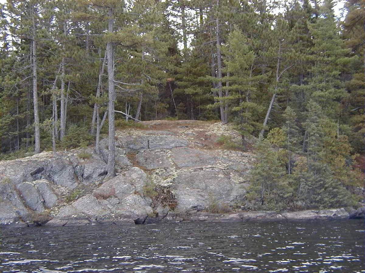
There are 7 forest communities and 3 wetland areas surrounding the tributaries, bays and shorelines in McLaren Forest Conservation Reserve. The major representations include old growth white and red pine uplands and old growth white pine mixedwoods. The modest representations include mature red maple and oak uplands, young to mature nutrient poor coniferous forest and mature nutrient rich coniferous forest. The small representations include young tolerant hardwood forest and mature intolerant hardwood coniferous forest. The old growth white and red pine forest has young white pine, black spruce, balsam fir, and white cedar. Some old growth white pine is thought to be at least 220 years old. The other coniferous and hardwoods are characteristic of the transition zone between the Boreal Forest and Great Lakes St. Lawrence Region. Understory vegetation includes such species as creeping snowberry, wintergreen, goldthread, blue bead lily, bunchberry, wild sarsaparilla and starflower. This type of vegetation is situated along the rocky shorelines of the bay area of the conservation reserve. The low lying more protected areas, such as the area north of Beaverland Road, contains tree species such as white and yellow birch, pin cherry, large toothed and trembling aspen, red and mountain maple along with some black spruce, pine, cedar and balsam fir species.
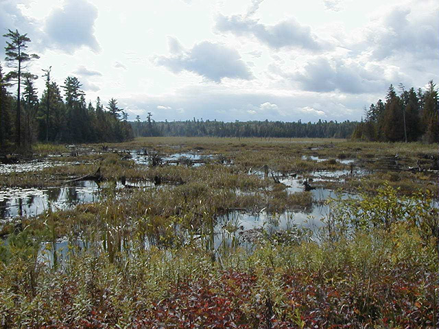
Wetland communities can also be found within the boundaries of the conservation reserve. They surround small creeks, bays and shoreline. Two fairly large wetlands can be found in the southwestern and northwestern portion of the site. The southwestern portion of the site is made up of marsh wetland with sedges, cattails, Labrador tea, and horsetails (photo 2). The northwestern section contains open water marsh, treed and semi treed bog and a floating fen.
Pine stands are important to a variety of wildlife including bears, deer moose, beaver, rabbit, grouse and various other species. Moose, bear, songbirds and small mammals seek shelter in the stands of old growth white pine. Birds are also known to feed on the seeds, bark and needles of white pine.
-
Diversity: Diversity is a measure of the conservation reserve’s earth and life science variety. The evaluation is based on the number and range (assortment) of landscape features and landforms for earth science values and the relative richness and evenness of the site’s life science components.
McLaren Forest Conservation Reserve is somewhat diverse in that it shows a number of different forest communities and wetlands in small area. Preliminary analysis shows the diversity rating is considered low (Burkhardt and Longyear, 2004). However, the coniferous and mixedwood vegetation, including old growth red and white pine is considered somewhat of an anomaly for this area, which has been so extensively logged in the past. Some trees are at least 220 years old. This old growth forest is not only aesthetically pleasing, but may also contain important genetic information about previously logged old growth forest. In addition, old growth forest contains essential and unique habitat for many species.
The conservation reserve is bordered by Marten Lake and Crown land with a few small interspersed pieces of patent land. Beyond Marten Lake the site is surrounded by the Nipissing Crown Game Preserve and Marten River Provincial Park. This is significant for many mammals that travel between park, game preserve and conservation reserve. There is some interspersion or edge effect within and at the boundaries of the conservation reserve. This is evident from the variety of features present within the conservation reserve including, old growth pine forest, wetlands, shoreline and small sections of low lying deciduous forest. This edge effect enhances the biodiversity within the conservation reserve by creating various transitional areas between different habitat types. Many species depend on a variety of habitat types for survival.
This edge effect along with the western portion of the site, which is currently surrounded by Crown forest, provides some wildlife diversity. A ground reconnaissance field survey revealed the presence of a variety of mammals such as beaver, deer, moose, bear and an assortment of small mammals. Conifer cover is known to be an important component of habitat for deer and moose. Conifers help to block wind and trap radiated heat while intercepting snow thereby creating a lower snow depth beneath the canopy. Supercanopy white pines are commonly used by black bears as refuge trees and bedding sites. Numerous wetland and upland birds also inhabit the site. Herons and waterfowl have been spotted within the site along with turkey vultures, crows, and even ruffed grouse, a favorite game bird among local residents. The open crowns of supercanopy white pines also make them an ideal nest and perch site for large raptors such as bald eagles and osprey. Mammals and birds are not the only species to inhabit the area, herpetofaunal species such as the American toad are also present within the site. All of these combined factors make this site biodiverse.
-
Condition: Overall the conservation reserve is in good condition with respect to its natural features. The level of disturbance within the area is rated as moderate. Remnants of a logging camp and tree stumps indicate that logging occurred in the past. There is also disturbance associated with the pipeline corridor. However, much of the original old growth white pine remains in the conservation reserve despite logging in the surrounding areas. In addition, an already established road, Highway 11, runs through the conservation reserve. There is some evidence of fire disturbance in the area (e.g., fire scars, burnt stumps and logs). Other natural disturbances, such as beaver activity have been observed along the shoreline and around the associated small tributaries within the conservation reserve. Recreational uses within the conservation reserve include the observation of old growth red and white pine, snowmobiling and ATV use, hunting, potentially hiking, camping/picnicking, wildlife viewing, photography and other general nature appreciation activities. These activities are considered to have a low impact because recreational activities take place along the already established roads and trails in already disturbed areas. A variety of authorized commercial activities such as baitfishing, trapping and bear management also occur in and around the area. However, these activities are believed to have little impact on the core ecological values of the site.
-
Ecological considerations: McLaren Forest Conservation Reserve is a small 410 hectare area comprised of Crown la The site is 439 hectares with addition of forest reserves. The site is ecologically linked to Marten River Provincial Park, Marten River Enhanced Management Area (E154r) and the Nipissing Crown Game Preserve. An already established major traffic corridor, Highway 11, runs through the center of the site fragmenting much of the habitat. The majority of the conservation reserve is bordered by Marten Lake. However, Crown land borders the site to the west and all areas are interspersed with patches of patent land which have been excluded from the site. The conservation reserve is somewhat buffered from adjacent land uses by following the natural shoreline surrounding much of the site. In addition, there is little human activity presently surrounding the site, thus, there is some added protection from adjacent Crown forest. However, this may change depending on future land use activities on adjacent lands. There are portions of the site that have vectored boundaries, particularly one large section at the southern end of the northwestern portion of the site. These vectored boundaries give rise to dissected forest communities that tend not to be ecologically self-contained. However, the core interior values for which the site was established, the old growth forest, are included within the site and are thus protected. The conservation reserve is used mainly for old growth forest observation, snowmobiling and ATV use along the already established pipeline facilitated trail, and for low impact hunting.
-
Special Features: The most unique feature of the conservation reserve is that it contains an abundance of old growth forest. These stands, which contain mostly coniferous species with some deciduous hardwoods, provide optimal habitat for a variety of wildlife.
White pine provides habitat for a variety of species such as deer and moose. Moose aquatic feeding areas have been identified at the northeastern portion of the site. Black bears commonly use large pine as refuge trees and bedding sites. The crowns of supercanopy pine offer ideal nesting and perch sites for species such as bald eagles and osprey. Certain species of woodpeckers, songbirds, hawks and owls prefer older growth forests to younger forests. Insects including dragonflies and beetles are known to appear more frequently and in greater variety in old growth forests. As the old growth vegetation dies and decays these trees continue to add diversity to the site. Snags provide nesting, foraging and denning sites for numerous species of birds and mammals. Fallen tree trunks provide shelter and foraging grounds for small mammals, salamanders and arthropods.
There is not only a greater diversity of wildlife in old growth forests but also a greater diversity of vegetation as well. Wetland vegetation, located at the northwestern portion of the site, in the floating fen warrants botanical exploration. In addition some mature and immature elm has been identified around the conservation reserve, thus there is potential that it may exist within the site. Elm trees have been ravished by Dutch elm disease and few mature trees are left in Ontario.
More types of lichen and fungi are present in older growth forests than younger ones. This appears true of this specific conservation reserve where in a great variety of lichen and moss species, including the ecologically sensitive reindeer lichen, were found in a very small area.
2.1 Life science
Gap analysis is a method of identifying gaps in representation of all landform/vegetation features within the Ecodistrict, and to identify potential sites that best fill those gaps. The objective of gap analysis is to complete representation of all vegetation community and landform types within protected areas (Bergsma, 1995). During the Lands for Life planning exercise, the emphasis for new protected areas was sites identified through gap analysis. McLaren Forest Conservation Reserve was not identified through gap analysis, but was originally put forward during the Keep it Wild Camgaign (1994) in an effort to fulfill the governments commitment to preserving old growth red and white pine. This area was chosen based on representative, genetic, historical and aesthetic values and its potential to help complete Ontario’s system of natural protected areas.
The conservation reserve consists of old growth coniferous forest with some mixedwood areas. The majority of forest stands that make up the site include mature and old growth white and red pine uplands and white pine mixedwoods. The supercanopy trees provide habitat for a variety of wildlife including land mammals and many birds. The presence of wetland areas also contribute to the diversity within the site. These wetlands include a marsh, bog and fen with some open water areas (figure 2).
2.2 Earth science
McLaren Forest Conservation Reserve lies within the Central Gneiss Belt of the Grenville Structural Province. The area is characterized by water-laid lowlands of discontinuous till interspersed with bedrock outcrops. The rolling hills include areas of bedrock drift complex and drift till from a former glacial deposit. A potential esker may lie at the southwestern portion of the conservation reserve. The rock type is predominantly metamorphic gneiss and the surficial layer is made up of an orthic humo-ferric podzol with a sandy loam to fine sandy loam texture. The noncalcareous very stony sand or sandy loam glacial till is of Precambrian origin. The drainage moisture regime is good on the gently to moderately rolling hills. The areas located near the creeks, rivers and bays contain wetland vegetation and thus organic soils and peatlands.
2.3 Cultural values
There are no archeological sites identified within the conservation reserve. There are some identified high potential heritage areas. High potential cultural heritage areas are identified using a computer based predictive modeling program. Based on a series of pre-defined parameters, the program identifies candidate areas, which are most likely to be culturally significant. The conservation reserve is within the area of interest of the Nipissing First Nation and the Temagami First Nation. The conservation reserve is also in close proximity to a heritage canoe route and trail that follows Marten Lake.
2.4 Recreational/aesthetic values
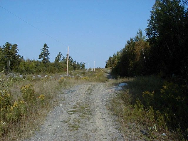
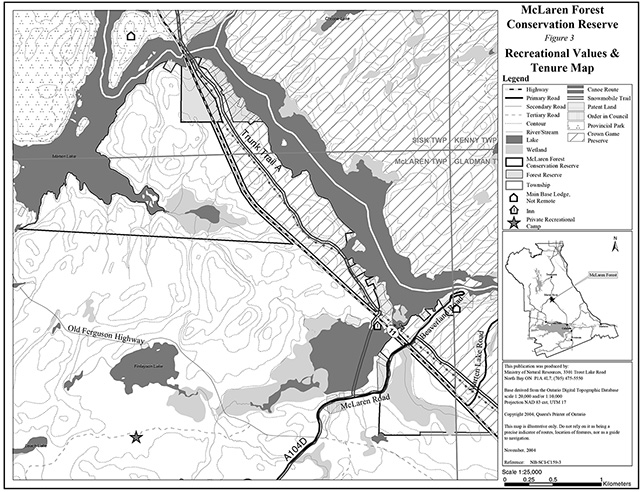
McLaren Forest Conservation Reserve offers recreational activities in close proximity to a major traffic corridor, Highway 11. The site, about half way between Temagami and North Bay, provides an aesthetically pleasing view of remnant of old growth red and white pine forest (photo 4). A snowmobile trail running parallel to the highway provides additional access to the site. This Ontario Federation of Snowmobile Clubs (OFSC) trail is utilized for snowmobiling in the winter and ATV use in the summer (photo 1). Cross-country skiing, snowshoeing or hiking may also take place along this trail. Additional access to the site can be gained by McLaren Road, a tertiary road that runs across the southeastern and western portion of the site. This road serves a secondary function as a snowmobile trail in the winter. The road provides potential access to the northwestern portion of the site, though, there are no trails leading directly into the site. The portion of the conservation reserve can be accessed by boat along the Marten River. The small size of this site, along with numerous trails and roads that surround it, make the site fairly accessible among recreational users.
Hunting and trapping are traditional recreational and commercial activities that are permitted within the majority of the conservation reserve. The sole area where hunting and trapping are not permitted is within the northeastern portion of the site which overlaps with the Nipissing Crown Game Preserve. Angling, canoeing, camping and picnicking may take place within or along conservation reserve boundaries (photo 3). However, due to the proximity of Marten River Provincial Park some of these activities may take place within the park instead. Photography, bird watching, nature study and other nature appreciation activities may also take place within the conservation reserve. The combination of old growth forests, wetlands and good accessibility may provide some valuable learning opportunities for students and the general public. The prospective interpretive value of the site may be fostered through initiatives with the staff of Marten River Provincial Park. The current and possible future recreational activities are believed to have a limited impact on the integrity of the site and thus will be permitted to continue.
2.5 Enhanced Management Areas
Enhanced Management Areas (EMAs) are a new land use category created in the Ontario’s Living Legacy Land Use Strategy. The EMA designation was established in order to provide more detailed land use direction in areas of special features or values. McLaren Forest Conservation Reserve is within EMA E154r, a recreational category EMA (figure 1). This 7,963 hectare area, which encompasses McLaren Forest Conservation Reserve, provides opportunities for a range of activities such as drive in and semi remote tourism and recreation while allowing compatible resource and land use activities to continue.
2.6 Forest reserves
A forest reserve is a land use designation applied to areas that were initially identified for inclusion in the conservation reserve but where subsequent detailed examination determined that there were existing mining claims or leases. Policies for forest reserves are similar to the policies for new conservation reserves, except that mining and related access will be permitted in a forest reserve.
This conservation reserve contains portions of several mining claims, which are currently designated as forest reserve. These forest reserve areas total 29 hectares. The intent of forest reserves is to regulate them as conservation reserve if the mining claims lapse.
The McLaren Forest Conservation Reserve is currently included in disentanglement discussions. Disentanglement examined OLL protected areas that overlap with pre-existing mining lands (claims designated as forest reserve) and will make recommendations to disentangle OLL protected areas from these lands. A result of the disentanglement negotiations between government, the mineral sector and conservationists may be dropping some of the forest reserves associated with C159 rather than adding them to the conservation reserve. This would only occur if no significant natural heritage values at risk and there is no significant impact on the protected area boundary.
Mining and surface rights have been withdrawn from staking within the conservation reserve boundaries under the Mining Act (RSO 1990 Chapter M.14). Therefore, no new claims can be staked within the conservation reserve boundary.
2.7 Heritage estate contributions
The conservation reserve has been set aside in order to protect the unique life science features associated with the site. The site was identified as possessing significant life science values through the Keep it Wild Campaign and reaffirmed during the Lands for Life planning process. Key features include:
- Old growth white pine forest
- Important area for wildlife including deer, moose, bear, grouse and various other species
The protection provided through designation, as a conservation reserve, will help to ensure the preservation of the site for future generations. Additional values and features not described here can be found in sections 2.0 and 2.1. Should a new, significant key value be identified, current management guidelines may be modified to ensure its protection
3.0 Management guidelines
3.1 Management planning strategies
The land use intent outlined in Ontario’s Living Legacy Land Use Strategy provides context and direction to land use, resource management, and operational planning activities on Crown land. Commitments identified in the above strategy and current legislation (PL Procedure 3.03.05) will form the basis for land use within McLaren Forest Conservation Reserve. For up-to-date information on permitted uses refer to the Crown Land Use Atlas.
Existing permitted uses within the conservation reserve may continue, unless they are shown to have a significant negative impact on the values within the site.
Proposed uses and development within the conservation reserve will be reviewed on a case-by-case basis. A Test of Compatibility (Appendix 1) must be passed before they are deemed acceptable. The emphasis will be on ensuring that the natural values of the conservation reserve are not negatively affected by current or future land use activities. Therefore, any application for new specific uses will be carefully studied and reviewed. The Ministry, partner organizations and/or proponents may undertake such studies. Requirements under MNR's Class Environmental Assessment for Provincial Parks and Conservation Reserves will also be met.
3.2 Land tenure
Background:
McLaren Forest Conservation Reserve consists entirely of Crown land. The site is generally surrounded by Crown land and Marten Lake. Patent properties have been excluded from the site (figure 1). Forest reserves have been excluded from the regulated boundary of the conservation reserve (see section 2.6).
Mining claims, which have been designated as forest reserves, are present in the northern portion of the site along Highway 11 and in the southwestern section of the site (figure 3). These forest reserves are currently included in disentanglement discussions (see section 2.6).
There are currently no recreation camps or land use permits within McLaren Forest Conservation Reserve. There are OFSC trails within the boundaries of the site.
Guideline:
The sale of Crown lands within the conservation reserve is not permitted.
Policies for forest reserves are similar to the policies for new conservation reserves, except that mining and related access will be allowed in a forest reserve.
No new claims can be staked within the conservation reserve boundary.
New recreation camps are not permitted.
Unauthorized occupations of lands within the conservation reserve will be handled in accordance with approved policy, and any required structural removal will be at the owner’s expense.
3.3 Development and access
Background:
Access to McLaren Forest Conservation Reserve can be achieved by road, boat or snowmobile in the winter. Highway 11 runs through the central portion of the conservation reserve with additional tertiary roads that expand out to the highway. A trail running parallel to the Highway can be accessed by both ATV in the summer and snowmobile in the winter using these tertiary roads. These roads include Beaverland Road, McLaren Road, and Marten Lake Road all located in the southern portion of the conservation reserve. Portions of both Beaverland Road and McLaren Road are utilized for snowmobile trails in the winter. There are no buildings within the conservation reserve. There is a gas pipeline station located in the southeastern portion of the conservation reserve. This station is accompanied by a gas pipeline that runs the length of the eastern portion of the site (figure 3). A small section of this trail/pipeline includes a telephone line.
Guideline:
New roads for resource extraction will not be permitted in the conservation reserve. New roads for private use will not be permitted, nor will additions to existing roads or upgrading of existing private roads.
New trails are not encouraged, however they may be considered when compatible with other recreational uses and the maintenance of environmental integrity. Any new trail development must go through a Test of Compatibility to ensure the quality of the life and earth science representation and any additional values (e.g. aesthetics, landscape views, sensitive areas) are maintained.
Existing snowmobile trails may be permitted in conservation reserves as long as they do not impair the natural features and values for which the area is identified and as long as there are no significant environmental impacts. Consideration for new snowmobile trails will occur on a case-by-case basis, but will not be encouraged. Public consultation will be an important part of the process.
In the case of ATV's, the demand, as well as the environmental impact of this activity, will be determined before specific trails are designated or constructed. In general, ATV trails will be discouraged.
The use of existing unauthorized trails will be monitored to ensure that conservation reserve values are not being adversely impacted. Depending on the results of the monitoring, some of the unauthorized trails may need to be redirected from sensitive areas or eliminated completely.
The district may sometime in the future consider developing a trails strategy to ensure the values within the conservation reserve are fully protected, while maintaining current permitted uses. Access to resources will include both direct access (e.g. current roads or trails) and/or more remote access (e.g. waterways) opportunities. Such planning could include public consultation.
Facility infrastructure and development for recreation may be considered in future if there is a demonstrated need for such facilities. A more detailed management plan would be required prior to construction.
3.4 Recreational activities
Background:
Existing recreational uses include observation of the old growth forests, snowmobiling, ATV use, hunting, hiking, snowshoeing, cross-country skiing, photography, bird watching, general nature study and potentially picnicking and camping. Canoeing and fishing may also take place in the vicinity of the conservation reserve.
Guideline:
Most recreational activities that have traditionally been enjoyed in this area can continue provided they pose no threat to the natural ecosystems and features protected by the conservation reserve.
Hunting is prohibited in the eastern section of the conservation reserve, which is included within the Nipissing Crown Game Preserve.
Mechanized travel is permitted only on existing trails. Off-trail mechanized travel is permitted for retrieval of game only.
New recreational activities will be considered on a case-by-case basis. Emphasis will be placed on activities that have a low impact on the environment of the conservation reserve.
3.5 Industrial activities
Background:
McLaren Forest Conservation Reserve is located within the Nipissing Forest but has been removed from the licensed area. An examination of the possible impact of activities on adjacent lands should be considered in the Forest Management Plan.
There is no existing timber harvesting or aggregate extraction activities within the conservation reserve. There is however a gas pipeline and section of utility line that runs along the main trail of the conservation reserve, parallel to Highway 11.
Mining and surface rights have been withdrawn from staking within the conservation reserve under the Mining Act (RSO Chapter M.14).
Guidelines:
Conservation reserve regulations do not permit mining, commercial forest harvesting, hydroelectric power development, the extraction of aggregate and peat or other industrial uses (Public Lands Act, Ontario Regulation 805/94).
Under the Ontario’s Living Legacy Land Use Strategy, mining and related access will be permitted in a forest reserve. For those activities that could negatively influence the natural heritage values within the forest reserve and/or the conservation reserve, the district will work with the proponent to identify and mitigate potential mining or natural heritage concerns.
Pipeline projects and operation activities associated with the existing pipeline will be permitted provided they are carefully planned and implemented with due regard for the protection of conservation reserve values.
Mining will not occur in any portion of the regulated conservation reserve boundary.
3.6 Commercial activities
Background:
The conservation reserve includes a part of a registered trapline (NB-15) and four baitfish licenses for the townships of McLaren, Sisk and Gladman. The conservation reserve includes portions of two Bear Management Areas (BMA) (NB-41-30 and NB-41-37). The Ministry of Natural Resources authorizes these activities.
Guideline:
Existing non-industrial commercial uses such as trapping and baitfish harvesting will be permitted to continue. However, hunting and trapping will not be permitted in the eastern section of the conservation reserve, within Nipissing Crown Game Preserve. These activities will continue to be monitored in order to ensure they do not deplete natural resources and that they impose a minimal impact on the features identified for protection.
New non-industrial commercial activities (i.e. traplines) which overlap with the conservation reserve, not within the bounds of the Nipissing Crown Game Preserve, may be considered subject to a Test of Compatibility (Appendix 1), consistent with provincial direction. Any new trails associated with the new non-industrial commercial activities must also be considered subject to a Test of Compatibility.
New trap cabins will not be permitted in the conservation reserve.
Existing commercial bear hunting operations are permitted to continue, excluding areas of conservation reserve that are part of the Nipissing Crown Game Preserve. The introduction of new operations will not be allowed.
The issuance of Licenses to Provide Bear Hunting Services will be allowed where areas have been licensed or authorized under agreement for the activity since January 1, 1992 (there must be documentation in Ministry files that commercial bear hunting has been licensed during the period January 1, 1992 to present) unless:
- The Government has taken action to discontinue the activity; or
- Proceeding would create/aggravate resource sustainability issues (e.g., wildlife management reasons, imparts on values); or
- Licensing or permitting should be deferred due to Aboriginal issues
Licenses to Provide Bear Hunting Services will not be issued in areas where issuance has not occurred since January 1, 1992.
3.7 Aboriginal interests
Background:
This site is located within the Robinson – Huron Treaty Area of 1850, and as such the general area of this conservation reserve is known to be of interest to various First Nations. Temagami First Nation and Teme-Augama Anishnabai, a group associated with Temagami First Nation, are currently in a land claim process with Ontario and Canada. Their area of interest is known to extend across the boundaries of the site. The site is also in the area of interest of Nipissing First Nation.
Guideline:
All aboriginal and treaty rights will continue to be respected and are not affected by the establishment of this conservation reserve.
Any future proposals or decisions that have potential impact(s) on the individual or aboriginal or community values will involve additional consultation with the affected aboriginal groups.
3.8 Natural Resource Stewardship
McLaren Forest Conservation Reserve includes at least 220 year old, old growth white pine forest with a mix of other coniferous, deciduous hardwoods and wetlands.
Based on the Ecosite Classification of McLaren Forest Conservation Reserve the onset of old growth for this site is 150 years for white pine and 140 years for red pine. An old growth forest can only retain its old growth status for a limited period of time, before succession takes place and the nature of the community is fundamentally changed. Once the pine has reached the age where it may be considered old growth, the community has another 80-160 years for white pine and 50-100 years for red pine, until the old growth pine is succeeded by hardwood forest consisting of spruce, balsam and poplar. In a natural system the site may retain its pine species composition through the occurrence of natural disturbance such as a fire, insect infestation or a blow down.
Old growth forests are known to create and maintain a fairly diverse environment with a variety of vegetation and wildlife. Various mosses and lichen can be found in the forest along with various birds, deer, moose, bear, beaver and many other small mammals. The transition zones between forest and wetland also benefit this diversity. This type of environment offers excellent tourism, hunting and nature study opportunities.
Guideline-vegetation:
The conservation reserve will be managed by allowing natural ecosystems and processes to function as they would with minimal human interference.
The MNR recognizes fire as an essential process fundamental to the ecological integrity of conservation reserves. MNR recognizes the need for forest fire disturbance to maintain the old growth white pine forest ecosystem. Theses disturbances are accepted as part of the life regeneration cycle of the natural forested landscape.
Prescribed burning may be utilized to emulate natural disturbances and renew forest communities, prepare seed beds for research and/or education purposes or to meet additional objectives determined within a separate vegetative management plan. All scheduled prescribed burns within the boundaries of a conservation reserve will consider factors such as fuel type, topography or slope, weather, ignition source and land use values and will be conducted as directed by the current Prescribed Burn Policy AF.03.23.02.
Opportunities for prescribed burning to achieve ecological or resource management objectives will be developed with public consultation prior to any prescribed burning, and reflected in the document that provides more management direction for this conservation reserve. Plans for any prescribed burning will be developed in accordance with the MNR Prescribed Burn Planning Manual, and the Class Environmental Assessment for Provincial Parks and Conservation Reserves.
In accordance with existing Conservation Reserve Policy and the Forest Fire Management Strategy for Ontario, forest fire protection will be carried out as on surrounding lands. In general, natural forest fires will be suppressed using low impact fires suppression techniques in order to protect human life and property. Whenever feasible, the MNR fire program will endeavor to use "light on the land" techniques, which do not unduly disturb the landscape, in this conservation reserve. Examples of light on the land techniques may include limiting the use of heavy equipment or limiting the number of trees felled during fire response efforts.
Personal use permits for wood harvesting are not permitted.
Programs may be developed to control forest insects and diseases in the conservation reserve where these threaten significant values in or adjacent to the site. Where insects or disease threaten significant values, in or adjacent to the site, control will be directed as narrowly as possible to the specific insect or disease. Biological control will be used whenever possible. Regard shall be had for the Test of Compatibility.
Guideline-fish and wildlife:
Fish and wildlife resources will continue to be managed in accordance with policies and regulations prevailing in the area and under the direction of the Tomiko Area Supervisor. Provincial legislation and policy will dictate management and enforcement objectives for both conservation reserve and the section of overlapping Crown Game Preserve.
3.9 Cultural Resource Stewardship
Background:
There have been no specific studies or inventories undertaken by the MNR within the conservation reserve and no specific cultural resource values that have been evaluated or identified to date. However, areas of high potential heritage have been identified within the site.
Guideline:
Should the MNR consider new structural development, significant clearing of vegetation or altering of land within this conservation reserve, the MNR will adhere to the cultural heritage resource screening process as is identified in its Memorandum of Understanding (MOU) with the Ministry of Culture (MCL). While the purpose of this MOU is to provide a process to identify and protect cultural heritage resources when the MNR is reviewing work permits or disposing of Crown rights under the authority of the Public Lands Act, the considerations and criteria would also enable the MNR to identify high potential cultural heritage areas for other purposes within conservation reserves. If the screening process indicates that the site of a proposed activity is within an area of high cultural heritage potential, the MNR will consult with the MCL to determine the appropriate cultural heritage assessment requirements and will undertake a preliminary archaeological assessment if appropriate.
3.10 Client services
Background:
There are currently no client services associated with this conservation reserve.
Guideline:
The focus will remain on low key information and self-interpretation of conservation reserve features. Messages should focus on the area’s natural heritage features, recreation opportunities, nature appreciation and education.
Information regarding the McLaren Forest Conservation Reserve may be delivered from different sources, however, MNR will be the lead agency for responding to inquiries. A management agreement may be pursued with an appropriate partner to share responsibilities for information services and the delivery of other aspects of this SCI.
Consideration will be given to the strategic location of signs where roads or trails cross the conservation reserve boundary. There are no other plans for structural development within this conservation reserve.
3.11 Monitoring, assessment and research
Background:
Research and assessment to date has included an earth science, life science and recreation checksheets. Since recommendations were provided, these checksheets have been used in the assessment of this site.
Guideline:
Consideration will be given to inventory and documentation of natural and cultural values, and the assessment of use/activity impacts. All research will be carried out in a non-destructive manner. Research proposals must follow Procedural Guideline C – Research Activities in Conservation Reserves (PL 3.03.05).
The collection/removal of vegetation and parts thereof will not be permitted; however, subject to a Test of Compatibility (Appendix 1), the Area Supervisor may authorize the collection of plants and/or parts for purposes of rehabilitating degraded sites within the conservation reserve and collecting seeds for maintaining genetic stock or research.
Research, education and interpretation will be encouraged to provide a better understanding of the management and protection of the natural heritage values and will be fostered through local and regional natural heritage programs, initiatives and partnerships.
3.12 Marketing
Background:
There has been no marketing of this conservation reserve to date. Promotion and information about this site has been primarily through the Ontario’s Living Legacy planning process and public consultation regarding the boundaries of this site.
Guideline:
Marketing activities of this conservation reserve will be kept to a minimum.
4.0 Implementation
Implementation of the SCI and management of the conservation reserve are the responsibility of the Tomiko Area Supervisor, North Bay District of the Ministry of Natural Resources.
Emphasis will be placed on awareness information highlighting conservation reserve values and appropriate uses.
Long-term management will consider balancing between maintaining the quality of representation and needs of recreation and other users.
5.0 Review and revision of the Statement of Conservation Interest
McLaren Forest Conservation Reserve SCI will be reviewed on an ongoing basis and will include the monitoring of activities to ensure adherence to management guidelines. Partnerships may be pursued to address management needs.
This SCI will be amended through a standard process of minor and major amendments. Minor amendments will be processed in a relatively informal manner and will require the approval of the Tomiko Area Supervisor. These amendments will deal with uses and activities that do not affect any of the policies in this SCI (e.g. new uses and/or activities that are consistent with existing permitted uses).
Uses and/or activities that were not anticipated in the approved SCI and which may have an impact on the values of the conservation reserve will require a major amendment. This will include an opportunity for public comment and input and will require the approval of the North Bay District Manager and Regional Director.
6.0 References
Bergsma, B. et al. 1995. Gap Analysis and Candidate Area Selection for Life Science Representation in Site District 5E-6. Ecological Services for Planning Limited.
Burkhardt, Barbara et al. 2003. Life Science Inventory Checklist Site District 5E-6, McLaren Forest Conservation Reserve (in progress).
Chambers, B.A., Naylor, B.J., Merchant, B. and Uhlig, P. 1997. Field Guide to Forest Ecosystems of Central Ontario.
Crins, W.J. and Uhlig, P.W.C. 2000. Ecoregions of Ontario: Modifications to Angus Hills' Site Regions and Districts. Unpublished Paper. Peterborough: OMNR.
Crins, W. J. and Kor, P. S. G. 1998. Natural Heritage Gap Analysis Methodologies Used by the Ontario Ministry of Natural Resources. Unpublished Paper. Peterborough: OMNR.
EMR Canada. 1995. Topographic Map 1:50,000. Marten Lake. Sheet 31 L/12.
First Nations Interviews. 1998 & 2003. Native Background Information Report and Values Maps related to Forest Management Planning.
Hills, G. A. 1959. A Ready Reference to the Description of the Land of Ontario and its Productivity. Division of Research Ontario Department of Land and Forests.
Kristjansson, F.J. 2003. Earth Science Inventory Checklist Site District 5E-6, McLaren Forest Conservation Reserve (in progress).
Morris, E. R. 2001. Natural Heritage Area Life Science Checksheet, Ecodistrict 4E-4, McLaren Forest Conservation Reserve (C159).
Noble, T.W. 1991. Assessment of Natural Areas and Features for the Northern Portion of the Southern Boreal Forest Region Site Region 5E.
OMAF. 1986. Soils of North Bay Area Ontario Soil Survey Report No. 54 1:50,000. Marten 31 L/12.
Ontario Ministry of Natural Resources (OMNR). 1989. Aerial Photos.
OMNR. 1997. Public Lands Directive Manual: Natural Heritage-PL 3.03.05.
OMNR. 1999. Ontario’s Living Legacy: Land Use Strategy. Peterborough: Queen’s printer for Ontario.
OMNR. North Bay District. 2003. C159 McLaren Forest Conservation Reserve File.
Vodicka, K. 2003. McLaren Forest Conservation Reserve Recreational Inventory Checklist.
Photos of McLaren Forest Conservation Reserve (C159)
Photo 1: Snowmobile trail and pipeline that runs through the eastern portion of the conservation reserve
Photo 2: Marsh area at the southwestern portion of the conservation reserve
Enlarge photo 2: Marsh area at the southwestern portion of the conservation reserve
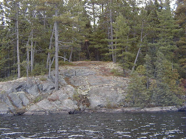
Photo 3: Potential campsite surrounded by white pine growing on rock in the northwestern portion of the conservation reserve
Photo 4: Old growth white pine towering above spruce and balsam fir on the eastern side of the conservation reserve
Appendix 1 Procedural Guideline B – Land Uses – Test of Compatibility (PL Procedure 3.03.05)
The Conservation Reserve policy provides broad direction with regard to the permitted uses. The policy provides only an indication of the variety of uses that will be considered acceptable in conservation reserves. The only caution is that "any new uses, and commercial activities associated with them, will be considered on a case by case basis, and, they must pass a test of compatibility to be acceptable." What does a ‘test of compatibility' mean?
An examination of this must start from the premise of why an area is set aside – specifically, its representative natural heritage values. Criteria are then identified to guide compatibility considerations. These criteria apply to the long-term acceptability of both existing uses and new uses.
-
Conformity to SCI/RMP: SCI describe values for which an area has been set aside and the range of appropriate uses that will be permitted in the area. SCI may also speak to the acceptability of other 'new' uses currently not occurring in the area.
The first 'test' is: "do proposed new land uses and/or commercial activities conform to the direction of the SCI/RMP for the conservation reserve? Would the new use(s) depart from the spirit of appropriate indicator land uses in the SCI/RMP?"
- Impact Assessment: If the proposed use(s) pass test 1 it is important to determine their impact on the area before they are approved. This should include the following:
- Impact on natural heritage values: "will the new use(s) impact any natural values in the area? If so how and to what degree? Is it tolerable?"
- Impact on cultural values: "will the new use(s) impact an historical or archaeological values in the area?"
- Impact on research activities: "will the new use(s) affect research activities in the area?"
- Impact on current uses: "will the new use(s) have any negative impact on the array of current uses?"
- Impact on area administration: "will the new use(s) increase administrative costs and/or complexity?" (For example, the cost of area monitoring, security and enforcement).
- Impact on accommodating the use outside the conservation reserve: "Could the use(s) be accommodated as well or better outside the conservation reserve?"
- Impact on socio-economics of the area: "will the new use(s) affect the community(ies) surrounding the area in a positive or negative way?" (For example, will the new use make an area less remote thereby affecting a local tourism industry that is dependent on the area’s remoteness for its appeal?"
- Impact on area accessibility: "does the new use(s) give someone exclusive rights to the area or a portion of the area to the exclusion of other existing uses?"
The following table provides a guide of indicator uses for the consideration of uses that may be permitted within conservation reserves. For any specific conservation reserve that test of compatibility should be applied to determine which specific uses are acceptable.
Appendix 2 - Public Lands Act Policy (3.03.05) Conservation Reserve Permitted Use Table
Indicator Uses for Conservation Reserves
Recreation
| Permitted Activities | Generic - Existing | Generic - New | (C159) Specific - New Uses |
|---|---|---|---|
| Sport fishing | Yes | Yes | Yes |
| Sport hunting | Yes* | Yes* | Yes* |
| Food gathering | Yes | Yes | Yes |
| Facility infrastructure | Maybe | Maybe | Maybe1 |
| Non-trail snowmobiling | Maybe1 | Maybe1 | Maybe2 |
| Non-trail ATV use | Maybe1 | Maybe1 | Maybe2 |
| Rock climbing/caving | Maybe | Maybe | N/A |
| Canoeing/kayaking | Yes | Yes | Yes |
| Motorized boating | Yes | Yes | Yes |
| Picnicking | Yes | Yes | Yes |
| Camping | Maybe | Maybe | Yes |
| Trails | Yes | Maybe | Maybe1 |
| Trails: Hiking | Yes | Maybe | Maybe1 |
| Trails: X county skiing | Yes | Maybe | Maybe1 |
| Trails: Cycling | Yes | Maybe | Maybe1 |
| Trails: Horse riding | Yes | Maybe | Maybe1 |
| Trails: Snowmobiling | Yes | Maybe | Maybe1 |
1New uses will be considered on a case by case basis provided they do not impact the natural heritage values for which the area was established, and must pass a test of compatibility to be acceptable.
2For retrieval of game only
xExcept in Crown Game Preserve
Science, education & heritage appreciation
| Permitted Activities | Generic - Existing | Generic - New | (C159) Specific - New Uses |
|---|---|---|---|
| Research | Yes | Yes | Yes |
| General walking | Yes | Yes | Yes |
| Photography and painting | Yes | Yes | Yes |
| Wildlife viewing | Yes | Yes | Yes |
| Outdoor education/interpretation | Yes | Yes | Yes |
| Collecting | No | No | No |
Commercial activities
| Permitted Activities | Generic - Existing | Generic - New | (C159) Specific - New Uses |
|---|---|---|---|
| Food harvesting | Maybe | Maybe | No |
| Fishing | Maybe | Maybe | No |
| Baitfish harvesting | Yes3 | Maybe | Yes |
| Trapping | Yes3 x | Maybex | Yesx |
| Trap cabins | Yes | No | No |
| Resort-outpost camp | Yes3 | No | No |
| Outfitting-bear management | Yes3 | No | Yes |
| Wild rice harvesting | Yes | Maybe | N/A |
Resource management
| Permitted Activities | Generic - Existing | Generic - New | (C159) Specific - New Uses |
|---|---|---|---|
| Inventory monitoring | Yes | Yes | Yes |
| Featured species management | Maybe | Maybe | Maybe |
Industrial activities
| Permitted Activities | Generic - Existing | Generic - New | (C159) Specific - New Uses |
|---|---|---|---|
| Natural systems management | Maybe | Maybe | Maybe |
| Timber harvesting | No | No | No |
| Prospecting | No | No | No |
| Mining | No | No | No |
| Hydro generation | No | No | No |
| Energy transmission corridors | Yes | No | No |
| Communications corridors | Yes | No | No |
| Transport corridors | Yes | No | No |
| Resource roads (MNR) | Yes | No | No |
| Land disposition | x | No | No |
| Hunt camps | Yes3 | No | No |
xExisting dispositions will continue, however, as opportunities arise the Ministry will acquire and/or remove them outside of the conservation reserve.
3Transfer requests will be considered in the context of a Statement of Conservation Interest (SCI) or Resource Management Plan (RMP) for each conservation reserve.
Appendix 3 – Glossary of terms
Arthropods: Any of numerous invertebrate animals of the phylum Arthropoda, including the insects, crustaceans, arachnids, and myriapods, that are characterized by a chitinous exoskeleton and a segmented
Calcareous: Composed of, containing, or characteristic of calcium carbonate, calcium, or limestone; chalky
Cultural Heritage: Collective term describing examples of a society’s evolution (e.g. history, anthropology and archaeology) worthy of study and preservation
Cultural Resource: Site, feature or artifact related to the Province’s archaeology, anthropology or history, preserved in a natural setting
Drift: All unconsolidated mineral material on the bedrock
Ecodistrict: An ecological landscape unit (ranging in resolution in hundreds of square kilometers) characterized by a distinct patterns in landform
Ecoregion: An ecological landscape unit (ranging in resolution from hundreds of thousands to tens of thousands of square kilometers) characterized by distinct patterns of responses to climate as expressed by soils, hydrology, vegetation (species ranges and productivity), and fauna
Esker: A knobby, crooked ridge of coarse gravel and sand considered to be deposited of melt water in crevasses and tunnels near the front of a glacier
Ferric: Of, relating to, or containing iron
Gneiss: A crystalline rock, consisting, like granite, of quartz, feldspar, and mica, but having these materials, especially the mica, arranged in planes, so that it breaks rather easily into coarse slabs or flags
Grenville Structural Province: The area of Precambrian bedrock composed of certain metasedimentary and metavolcanic rocks located in the Canadian Shield or Georgian Bay-Ottawa Valley region
Herpetofaunal: A catalog of animals that are concerned with amphibians and reptiles
Humic: Of, relating to, or derived from humus
Lacustrine: Of or relating to lakes
Loam: A soil composed of a mixture of relatively equal and moderate proportions of clay, silt and sand particles, and which may or may not contain organic matter (humus)
Metamorphic: Altered in physical structure or chemical composition by action of heat, pressure, shearing stress, or intrusion of elements, all taking place at substantial depth beneath the surface
OBM: Ontario Base Map, refers to a geographic division of Ontario according to lines of longitude into mapsheets based on the UTM map projection system
Ortho: Straight; upright; vertical
Patent: An exclusive right or title
Peatland: The extensive areas of northern Ontario having organic soils
Podzolic soils: Are well and imperfectly drained soils that have developed under coniferous and mixed-forest vegetation and heath, mostly in moist, cool to temperate climates. The profiles have a distinctive ash-grey horizon under the dark, humified surface horizon. They are acid soils of low fertility
Precambrian: All of geologic time older than the Cambrian Period, that is, older than 600 million years
Prescribed burning: The deliberate, planned and knowledgeable application of fire by authorized personnel and in accordance with MNR policy and guidelines to a specific land area to accomplish pre-determined forest management or land management objectives
Till: The heterogeneous mixture of clay, sand, pebbles and boulders deposited directly by a glacier
UTM: Universal Transverse Mercator
Figure 1: Location map
Enlarge figure 1: Location map
Figure 2: Forest values map
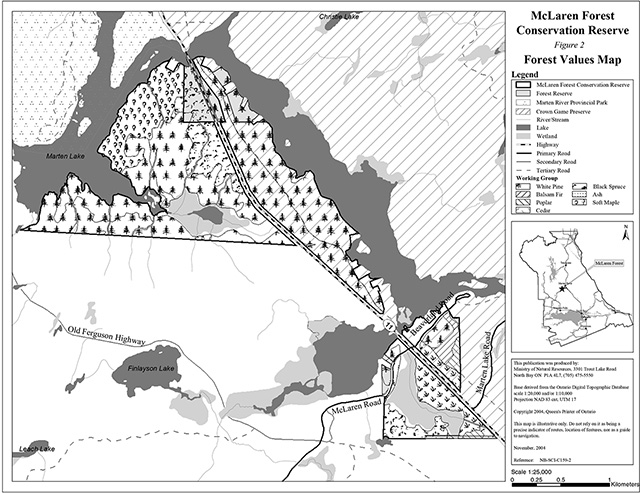
Enlarge figure 2: Forest values map:
Figure 3: Recreational values and Tenure map
Footnotes
- footnote[1] Back to paragraph Dictionary.com. 2003. Lexico Publishing Group. www.dictionary.com
- footnote[2] Back to paragraph OMNR. 1992. Ontario Provincial Parks: Planning and Management Policies: 1992 Update. OMNR
- footnote[3] Back to paragraph Chapman, L.J, and D.F. Putnam. 1984. The Physiography of Southern Ontario, Third Edition. Ontario Geological Survey
- footnote[4] Back to paragraph Crins, William J and Peter W.C. Uhlig. 2002. Ecoregions of Ontario: Modifications to Angus Hills' Site Regions and Districts Revisions and Rationale.
- footnote[5] Back to paragraph OMNR. 1996. Forest Management Planning Manual. Toronto: Queen’s Printer for Ontario
- footnote[6] Back to paragraph Strahler, Alan and Arthur Strahler. 1997. Physical Geography Science and Systems of the Human Environment
- footnote[7] Back to paragraph OMNR. 2001. Glossary. http://www.mnr.gov.on.ca/mnr/forests/forestdoc/ebr/fimpdfs/glossary.pdf (link is no longer active)
- footnote[8] Back to paragraph Fire in Parks and Conservation Reserves Policy and Planning Team. 2003. Statements of Conservation Interest –Suggested Wording for Fire Management Direction