Mudcat Lake Forest Conservation Reserve Management Statement
This document provides policy direction for the protection, development and management of the Mudcat Lake Forest Conservation Reserve and its resources.
Statement of Conservation Interest
Ontario Ministry of Natural Resources
North Bay District
Approval statement
We are pleased to approve this Statement of Conservation Interest (SCI) for the Mudcat Lake Forest Conservation Reserve (C160).
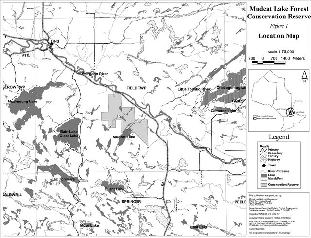
Mudcat Lake Forest Conservation Reserve is located in Ecodistrict 5E-6 approximately 15 km north of Sturgeon Falls between Clear Lake Road and Highway 64 (Figure 1). The boundary of the conservation reserve is located in the geographic township of Field within the Corporation of the Municipality of West Nipissing in the District of Nipissing (Figure 2). Part of the conservation reserve borders Mudcat Lake to the south and Highway 64 to the north. The conservation reserve is known to encompass significant life science values. A forest community of mixed deciduous and coniferous vegetation dominates the area.
Mudcat Lake Forest Conservation Reserve is one of 378 new protected areas approved through Ontario’s Living Legacy, a land use strategy aimed, in part, at completing Ontario’s system of parks and protected areas.
During the Lands for Life planning process the public was widely consulted and provided valuable input into what became Ontario’s Living Legacy. Comments received during that time, and during consultation related to the formal Public Lands Act regulation of the boundaries of this conservation reserve were generally supportive of the protection of this area.
Stakeholders who expressed an interest in the planning of this site were also notified regarding the draft SCI and given a two week review period. Any comments, including input from previous consultation, were considered in the finalization of this document. There was limited interest expressed by the public during the review of the draft SCI. No new issues have been identified. This SCI was also reviewed by MNR staff.
This SCI provides guidance for the management of the conservation reserve and the basis of the ongoing monitoring of activities. More detailed direction is not anticipated at this time. Should significant facility development be considered or complex issues arise requiring additional studies, more defined management direction or special protection measures, a more detailed Resource Management Plan will be prepared with full public consultation.
Mudcat Lake Forest Conservation Reserve is managed under the direction of the District Manager and the Tomiko Area Supervisor, North Bay District, Ministry of Natural Resources.
Prepared by:
Klara Vodicka
OLL Planning Intern
Date: December 15, 2003
Original signed by:
Dave Payne
District Manager
North Bay District
Date: December 19, 2003
Original signed by:
Rob Galloway
Regional Director
Northeast Region
Date: January 9, 2004
1.0 Introduction
The purpose of this Statement of Conservation Interest (SCI) is to identify and describe the values of the Mudcat Lake Forest Conservation Reserve. The SCI also outlines the activities that occur within the conservation reserve and provides guidelines for the management of current and future activities in the context of protecting the natural, social and cultural values of the conservation reserve. A SCI is prepared under the authority of Procedural Guideline A – Resource Management Planning (PL. Procedure 3.03.05).
Mudcat Lake Forest Conservation Reserve is a 396 hectare parcel of Crown land located southwest of the Sturgeon River, approximately 15 km north of Sturgeon Falls. The boundary of the conservation reserve is located in the geographic township of Field within the municipality of West Nipissing (figure 1). The mixed deciduous and coniferous forests provide optimal habitat for a variety of wildlife and thus recreational hunting opportunities within the conservation reserve.
Conservation reserves are established by regulation under the Public Lands Act. Mudcat Lake Forest Conservation Reserve was established by Ontario Regulation 313/02, under authority of the Public Lands Act (O. Reg. 805/94) on December 7, 2002. The planning area for this SCI is the regulated boundary of the conservation reserve.
1.1 Planning context
Ontario’s Living Legacy Land Use Strategy was approved in 1999. The objectives of the Land Use Strategy are to complete Ontario’s system of protected areas; recognize the land use needs of resource-based tourism industry; provide forestry, mining and resource industries with greater certainty around land and resource use; and enhance hunting, angling and other Crown land recreational opportunities. Mudcat Lake Forest Conservation Reserve was created as part of the expansion of protected areas.
Conservation reserves protect natural heritage values on public lands, while permitting compatible land use activities. By allocating these lands to the parks and protected areas system through regulation, the province has ensured a certain level of permanence by distinguishing the conservation reserve and its values from the larger general use or more extensively managed landscape. In addition, the conservation reserve’s natural features are, and will be available for present and future generations to enjoy and explore.
Ontario’s Living Legacy Land Use Strategy (1999) outlines the general land use policy and management direction for new conservation reserves. Each new conservation reserve will have a planning document, either a SCI or, in more complex situations, a Resource Management Plan, that details site-specific management direction.
Comments received during the Lands for Life process, and during consultation related to the formal regulation of the boundaries of this site were generally supportive of the establishment of this area as a conservation reserve. Stakeholders who expressed an interest in the planning were notified regarding the draft SCI and given a two-week review period where the draft was made available. Any comments, including input from previous consultation, were considered in the finalization of this document. There was limited interest expressed by the public during the review of the draft SCI. This SCI was also reviewed by MNR staff.
Although more detailed direction is not anticipated at this time, should significant facility development be considered or complex issues arise requiring additional studies, more defined management direction or special protection measures, a more detailed Resource Management Plan will be prepared with full public consultation.
1.2 Background information
Mudcat Lake Forest Conservation Reserve is a mixed deciduous and coniferous forest southwest of Highway 64 and 15 km north of Sturgeon Falls. The site formerly in Ecodistrict 5E-5 (Hills, 1959) now falls within Ecodistrict 5E-6 (Crins, 2000) in the revised version of Hills original Site Regions and Districts. The conservation reserve is surrounded by patent and Crown land. Part of the southern portion of the conservation reserve is bordered by the northern shore of Mudcat Lake (figure 1). This 396 hectare area was protected in order to preserve the valuable life science features and wildlife habitat associated with the site. The area can be accessed at the northern portion of the conservation reserve which is adjacent to Highway 64, though there are no trails leading into the protected area. There is a trail at the eastern portion of the site, however this trail is gated, and signed as no trespassing, as it crosses private land before entering the conservation reserve.
The following chart summarizes administrative information for Mudcat Lake Forest Conservation Reserve:
| Name and OLL ID Number | Mudcat Lake Forest Conservation Reserve (C160) |
|---|---|
| Ecoregion/Ecodistrict (Hills, 1959; Crins, 2000) | 5E (Georgian Bay), 5E-6 (Tomiko) |
| OMNR Administrative Region/District/Area | Northeast Region/North Bay District/ Tomiko Area |
| Total Area (ha.) | 396 |
| Regulation Date | December 7, 2002 (O. Reg. 805/94) |
| Township(s) | Field, now Municipality of West Nipissing |
| First Nations | Nipissing First Nation – area of interest – through the Robinson Huron Treaty |
| OBM map sheets | 2017 5800 51400 – 2017 5700 51400 |
| Topographic Map Name/Number | Sturgeon Falls 31 L/5 |
| UTM coordinates | 578,000 m E 5,148,000 m N |
| General Location, Description, Access | Approximately 15 km north of Sturgeon Falls. Site contains mixed deciduous and coniferous forest. There is no known access to the site. However, the northern most portion of the conservation reserve borders Highway 64. As well, there is a trail within conservation reserve boundaries that originates from a gated entrance located on private land from Highway 64. |
1.3 Goals
The goals of this SCI are:
- To provide background information
- To identify and describe the values of the conservation reserve
- To provide guidelines for the management of current and future activities while protecting natural, social and cultural heritage values
1.4 Objectives
The following objectives are identified as a means to achieve the above-stated goals.
- To describe the state of the resource with respect to natural heritage values and current land use activities
- To manage the conservation reserve to protect the integrity of its natural values via specific guidelines, strategies and prescriptions
- To meet planning requirements by addressing the management intent of the conservation reserve and addressing planning and management needs
- To create a public awareness of the values within the conservation reserve and promote responsible stewardship of the protected area through partnerships with local stakeholders
- To determine long-term management goals of the conservation reserve by identifying research, client services and marketing strategies
- To identify scientific values on the site in relation to provincial benchmarks and identify the necessary monitoring and/or research to maintain the integrity of those values
- To provide direction to evaluate new uses or economic ventures through the application of a Test of Compatibility ((Procedural Guideline B) - Land Uses - PL. 3.03.05) (Appendix 1)
1.5 Representation
The following table provides a summary of the life science, earth science and cultural heritage values, as well as recreational opportunities.
Life science representation:
15 forest communities and 4 wetland types lying on rolling water-laid lowlands broken by bedrock outcrops The following landform types and vegetation associations are found (Merchant et al., 2003):
- Lacustrine and weakly broken ground moraine with mixed deciduous and coniferous vegetation
- Fairly even split between deciduous and coniferous forest
- Deciduous forest approaching northern limits of its range
- Approximately 50% of the site contains candidates for old growth forest Balsam fir, white birch and poplar are the three largest stands within the site White birch, fir, spruce, maple and cedar are found on flat sedimentary deposits Fir, yellow birch and cedar are found on low rolling gravelly moraine deposits
- Sensitive lichen and moss species are present
- Presence of mast trees such as oak which produce understory and overstory fruit
- Acorns are valuable source of nutrition for deer, bears and wood ducks
- Presence of hemlock provides excellent winter cover for the strong deer and moose population
- Moose feed on favored aquatic vegetation
- Small wetland areas present near Mudcat Creek and tributaries
- Wetland includes cedar swamp, black spruce bog, shrub fen and a few open water marsh areas
- Site is fairly remote, well buffered and has limited access
Earth science representation:
Mudcat Lake Forest Conservation Reserve lies on the Tilden Lake and Nepewassi domains of the Central Gneiss Belt of the Grenville Structural Province. The area is characterized by water-laid lowlands interspersed with rugged bedrock outcrops. The rock type is predominantly biotite gneiss derived from greywackes and immature sandstone. The surficial layer is made up of flat sedimentary deposits and low rolling gravelly moraine deposits which range in size from gravel to silty sands (Kristjansson, 2003).
Cultural heritage values:
Mudcat Lake Forest Conservation Reserve was identified as having high potential heritage areas within the site (see section 2.3). The conservation reserve is in the area of interest for the Nipissing First Nation. More in-depth research concerning cultural heritage values has not been completed to date.
Recreational opportunities:
The site offers limited recreational opportunities due the restricted access to the site. Hunting, camping and nature appreciation activities such as bird watching, hiking, wildlife photography and viewing can be carried within the conservation reserve (Sheppard, 2002).
1.6 Survey work
The following table provides an overview of inventories completed, their level of detail, and any further inventories that are required.
| Survey Level | Life Science | Earth Science | Cultural | Recreational |
|---|---|---|---|---|
| Reconnaissance | Merchant, B. et al. 2003, Life Science Checksheet Aerial Survey | Kristjansson, F.J.,2003, Earth Science Checksheet, Aerial Survey (in progress) | First Nations Interviews, 1998 & 2003, Native Background Information Report and Values Maps, related to Forest Management Planning | Sheppard, C., 2002, Recreational Inventory Checklist, Aerial and Ground Survey |
| Detailed | None | None | None | None |
| Requirement | None | None | None | Monitor on on-going basis |
2.0 State of the resource
The conservation reserve is located entirely within Ecodistrict 5E-6 (Crins, 2000). Values include life science, earth science, cultural and recreational/aesthetic with an emphasis on the life sciences.
Significance is determined on the basis of the following criteria: representation, diversity, condition, ecological considerations and special features (Crins and Kor, 1998).
-
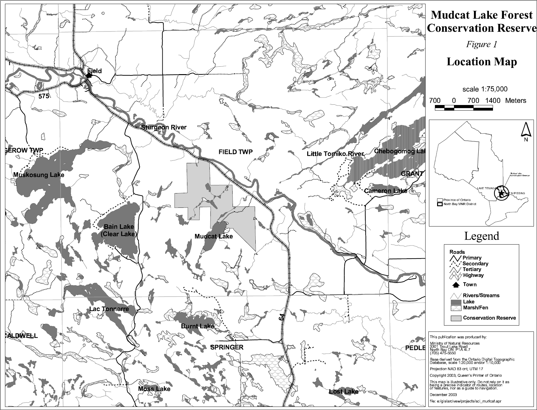
Representation: Mudcat Lake Forest Conservation Reserve is comprised of mixed deciduous and coniferous vegetation with a small section of wetland surrounding the tributaries (figure 2).
There are 15 forest communities and 4 small wetland areas surrounding the tributaries within Mudcat Lake Forest Conservation Reserve. The mixed deciduous and coniferous forest consists of a variety of species. Balsam fir mixedwoods dominate the northern portion of site covering 23% of the land base while white birch makes up 11% of the central portion. The eastern portion contains poplar mixedwoods with approximately 8% coverage and cedar mixedwoods with 7% coverage. There is an abundance of other mixedwood, hardwood and conifer forest communities present. These communities include species such as balsam fir, poplar, white birch, sugar maple, red maple, trembling aspen, white spruce, black spruce, white pine, cedar, hemlock, red oak, black ash, and possibly yellow birch in a variety of combinations. White birch, balsam fir, white and black spruce, red maple, sugar maple and cedar can be found in areas that contain flat sedimentary deposits. Balsam fir and cedar can be found on low rolling gravelly moraine deposits. Red oak and sugar maple stands can be found near the lacustrine deposit and rockland area located at the northern portion of the site. Wetland communities surround Mudcat Creek and other tributaries within the central portion of the conservation reserve. These wetlands include shrub fens and a few small open water marsh areas. A large cedar swamp is located at the northeast portion of the site, at the north shore of Mudcat Lake, while a large black spruce bog is located at the southeast corner of the site.
-
Diversity: Diversity is a measure of the conservation reserve’s earth and life science variety. The evaluation is based on the number and range (assortment) of landscape features and landforms for earth science values and the relative richness and evenness of the site’s life science components.
Mudcat Lake Forest Conservation Reserve is fairly diverse in that it shows a number of different forest communities and wetlands. The mixed deciduous vegetation, including red oak and sugar maple, is considered an anomaly for this area. Preliminary analysis shows the diversity rating is considered moderate.
-
Condition: Overall the conservation reserve is in good condition with respect to its natural features. The disturbance for the area has been rated as low. Logging activities have not occurred within the conservation reserve in the past 25 years. There is also no known fire disturbance in the area. Other natural disturbances, such as beaver activity have been observed within the associated small tributaries. Recreational uses within the conservation reserve include hunting, camping, bird watching, hiking, wildlife viewing, photography and other general nature appreciation activities. However, these activities are considered to have a fairly low impact because access to the site is limited. A variety of authorized commercial activities such as baitfishing, trapping and bear management also occur in and around the area. However, these activities are believed to have little impact on the core ecological values of the site.
-
Ecological considerations: Mudcat Lake Forest Conservation Reserve is a small 396 hectare area comprised of Crown land. The conservation reserve is bordered by patent land to the east and mostly Crown land to the west. A highway and private land border the conservation reserve to the north, while the south is bordered by Mudcat Lake (photo 2) and a combination of private and Crown land. The surrounding area is not well buffered nor is the site ecologically self-contained. The vectored boundaries give rise to dissected forest communities, which have a limited buffering capacity for the site’s interior core values. Pressure could be inflicted on the site in the future, depending on the type of land use activities occurring in adjacent areas. The conservation reserve is mainly used for low impact hunting, trapping, and bear management purposes.
-
Special Features: The most unique feature of the conservation reserve is that it contains and abundance of different mixed forest stands. These stands contain a fairly even split of deciduous and coniferous species. The area contains deciduous hardwoods, such as red oak and sugar maple which are approaching their northern limits. Red oak which grows on rock in this area is a unique life science feature of the site. Red oak is the single most important mast producing tree in the Great Lakes St. Lawrence Forest. Red oak produces both overstory and understory fruits. Overstory fruits include acorns while understory fruits include blueberries and cherries. These fruits, which are of high nutritional value, are particularly appealing to bear, deer and wood ducks which reside and visit the area. As well, areas of exposed bedrock and shallow soils contain patches of ecologically sensitive moss and lichen species. These species, including reindeer lichen, have nutritional value to species that inhabit this forest. In addition, the presence of conifer species, such as hemlock, provides optimal living conditions for a variety of wildlife. Hemlock blocks wind and traps radiated heat while intercepting falling snow on its foliage thus creating a lower snow depth beneath the tree. Deer and moose are known to utilize these areas for cover.
2.1 Life science
Gap analysis is a method of identifying gaps in representation of all landform/vegetation features within the Ecodistrict, and to identify potential sites that best fill those gaps. The objective of gap analysis is to complete representation of all vegetation community and landform types within protected areas (Bergsma, 1995). This conservation reserve was identified through gap analysis and contains 15 different forest communities as well as four different wetlands communities.
The conservation reserve consists of a mixed deciduous and coniferous forest. The forest stands that make up the majority of the site include balsam fir, white birch and poplar. However there is a sizeable variety of other mixedwoods, hardwoods and coniferous species as well. Deciduous species, such as red oak, which are present at the northern limits of their range, provide food for a variety of wildlife. Dense patches of eastern hemlock provide excellent cover making the area a hub for wildlife. There is a small amount of wetland vegetation surrounding Mudcat Creek and various tributaries that adds to the diversity of the site. These wetland areas include a bog, swamp, fen and marsh with some floating aquatic vegetation which borders the site at Mudcat Lake. This vegetation is a known source of food for moose populations.
2.2 Earth science
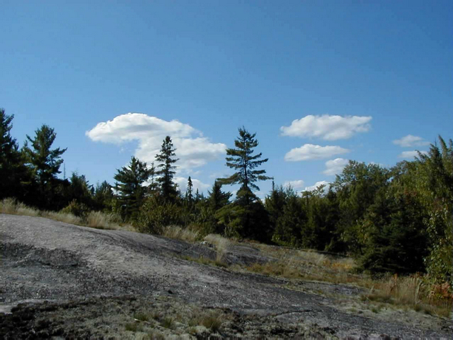
Mudcat Lake Forest Conservation Reserve lies on the Tilden Lake and Nepewassi domains of the Central Gneiss Belt of the Grenville Structural Province. The area is characterized by water-laid lowlands interspersed with bedrock outcrops, shallowly to deeply covered rock knobs (photo 4) and sand filled depressions. This lacustrine deposit and weakly broken end moraine includes areas of exposed bedrock. The rock type is predominantly biotite gneiss derived from greywackes and immature sandstone. The surficial layer is made up of flat sedimentary deposits and low rolling gravelly moraine deposits which range in size from gravel to silty sands.
2.3 Cultural values
There are no archeological sites identified within the conservation reserve. There are some identified high potential heritage areas. High potential cultural heritage areas are identified using a computer based predictive modeling program. Based on a series of pre-defined parameters, the program identifies candidate areas, which are most likely to be culturally significant. The conservation reserve is within the area of interest of the Nipissing First Nation. The conservation reserve is also in close proximity to a heritage canoe route which follows the Sturgeon River.
2.4 Recreational/aesthetic values
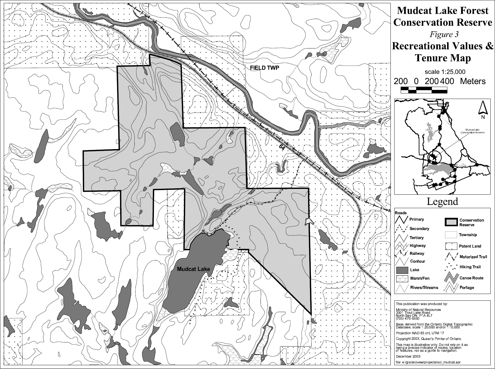
Recreational activities such as hunting and camping are popular activities within the conservation reserve. The area is known for its hunting appeal due to the many deer, moose and bear that are present within the area. Local residents as well as tourist operators and their clients frequent the site. A known campsite is located at the southern portion of the conservation reserve on the northern shore of Mudcat Lake (photo 1). A trail suitable for ATV use and hiking leads into this site. However, this trail extends from a trail located on private land which originates from a gated entrance at Highway 64 (figure 3). Thus, there is no public access to the site. The northern most portion of the conservation reserve is in close proximity to Highway 64, and thus, access could be established though there are no authorized trails at this location. There are opportunities for other activities such as bird watching, hiking, photography, wildlife viewing and general nature study. The location of the conservation reserve makes all of these activities even more appealing due to its close proximity to the communities of Field and Sturgeon Falls. However, difficulty in accessing the site will likely discourage some visitors.
2.5 Heritage estate contributions
The conservation reserve has been set aside in order to protect the unique life science features associated with the site. The site was identified as possessing significant life science values through gap analysis during the Lands for Life planning process. The area encompasses mixed deciduous vegetation including such species as red oak which is at the northern limits of its range. The understory vegetation provides an optimal habitat for a wide range of wildlife. The conservation reserve is known for supporting moose and deer populations. This is especially of great interest to hunters who use the area recreationally. The conservation reserve provides a remote location, with limited access and human interference, in close proximity to the population center of Sturgeon Falls. The protection provided through designation, as a conservation reserve, will help to ensure the preservation of the site for future generations. Mudcat Lake Forest Conservation Reserve will provide many of the same recreational opportunities to future generations that currently exist there today.
3.0 Management guidelines
3.1 Management planning strategies
The land use intent outlined in Ontario’s Living Legacy Land Use Strategy provides context and direction to land use, resource management, and operational planning activities on Crown land. Commitments identified in the above strategy and current legislation (PL Procedure 3.03.05) will form the basis for land use within Mudcat Lake Forest Conservation Reserve. For up-to-date information on permitted uses refer to the Crown Land Use Atlas at /page/crown-land-use-policy-atlas.
Existing permitted uses within the conservation reserve may continue, unless they are shown to have a significant negative impact on the values within the site.
Proposed uses and development within the conservation reserve will be reviewed on a case-by-case basis. A Test of Compatibility (Appendix 1) must be passed before they are deemed acceptable. The emphasis will be on ensuring that the natural values of the conservation reserve are not negatively affected by current or future land use activities. Therefore, any application for new specific uses will be carefully studied and reviewed. The Ministry, partner organizations and/or proponents may undertake such studies. Applicable environmental assessment requirements will also be met.
3.2 Land tenure
Background:
Mudcat Lake Forest Conservation Reserve consists entirely of Crown lands. The conservation reserve is surrounded by a mixture of Crown and patent land. Most of the patent land surrounds the eastern portion of the conservation reserve, while Crown land surrounds most of the western portion.
There are no recreation camps, land use permits or snowmobile trails within Mudcat Lake Forest Conservation Reserve.
Guideline:
The sale of Crown lands within the conservation reserve is not permitted. New recreation camps are not permitted.
Unauthorized occupations of lands within the conservation reserve will be handled in accordance with approved policy, and any required structural removal will be at the owner’s expense.
3.3 Development and access
Background:
Highway 64 runs northeast of the conservation reserve. The northern most portion of the conservation reserve is the closest access point to the conservation reserve. However, there are no trails leading from this potential access point. There is a trail within the site which is suitable for hiking or ATV use. This trail leads to a known campsite, but access is not possible. The trail within the conservation reserve extends from a trail which originates from a gated entrance located on private land off of Highway 64 (photo 3). Thus, trespassing would be required in order to access the site. There are no buildings, facilities or utilities within the conservation reserve (figure 3).
Guideline:
New roads for resource extraction and/or private use will not be permitted, nor will additions to existing roads or upgrading of existing private roads.
New trails are not encouraged, however they may be considered when compatible with other recreational uses and the maintenance of environmental integrity. Any new trail development must go through a Test of Compatibility to ensure the quality of the life and earth science representation and any additional values (e.g. aesthetics, landscape views, sensitive areas) are maintained.
Consideration for new snowmobile trails will occur on a case-by-case basis, but will not be encouraged. Public consultation will be an important part of the process.
In the case of ATV's, the demand, as well as the environmental impact of this activity, will be determined before specific trails are designated or constructed. In general, ATV trails will be discouraged.
The use of existing unauthorized trails will be monitored to ensure that conservation reserve values are not being adversely impacted. Depending on the results of the monitoring, some of the unauthorized trails may need to be redirected from sensitive areas or eliminated completely.
The district may sometime in the future consider developing a trails strategy to ensure the values within the conservation reserve are fully protected while maintaining current permitted uses to occur. Access to resources will include both direct access (e.g. current roads or trails) and/or more remote access (e.g. waterways) opportunities. Such planning could include public consultation.
Facility infrastructure and development for recreation may be considered in future if there is a demonstrated need for such facilities. A more detailed management plan would be required prior to construction.
3.4 Recreational activities
Background:
Existing recreational uses include hunting, camping, bird watching, hiking, photography, wildlife viewing and general nature study.
Guideline:
Most recreational activities that have traditionally been enjoyed in this area can continue provided they pose no threat to the natural ecosystems and features protected by the conservation reserve
Mechanized travel is permitted only on existing trails. Off-trail mechanized travel is permitted for retrieval of game only.
New recreational activities will be considered on a case-by-case basis. Emphasis will be placed on activities that have a low impact on the environment of the conservation reserve.
3.5 Industrial activities
Background:
Mudcat Lake Forest Conservation Reserve is located within the Nipissing Forest but has been removed from the licensed area. An examination of the possible impact of activities on adjacent lands should be considered in the Forest Management Plan.
There are no existing mining, timber harvesting, aggregate extraction or utility activities within the conservation reserve.
Mining and surface rights have been withdrawn from staking within the conservation reserve under the Mining Act (RSO Chapter M.14).
Guidelines:
Conservation reserve regulations do not permit mining, commercial forest harvesting, hydroelectric power development, the extraction of aggregate and peat or other industrial uses (Public Lands Act, Ontario Regulation 805/94).
3.6 Commercial activities
Background:
The conservation reserve includes a part of registered trapline (NB-21) and baitfish license area for Field Township. The conservation reserve includes two Bear Management Areas (BMA) (NB 41-55 and NB 41-45). The Ministry of Natural Resources authorizes these activities.
Guideline:
Existing non-industrial commercial uses such as trapping and baitfish harvesting will be permitted to continue. These activities will continue to be monitored in order to ensure they do not deplete natural resources and that they impose a minimal impact on the features identified for protection.
New non-industrial commercial activities (i.e. traplines) which overlap with the conservation reserve may be considered subject to a Test of Compatibility (Appendix 1), consistent with provincial direction. Any new trails associated with the new non-industrial commercial activities must also be considered subject to a Test of Compatibility.
New trap cabins will not be permitted in the conservation reserve.
Existing commercial bear hunting operations are permitted to continue but the introduction of new operations will not be allowed.
The issuance of Licenses to Provide Bear Hunting Services will be allowed where areas have been licensed or authorized under agreement for the activity since January 1, 1992 (there must be documentation in Ministry files that commercial bear hunting has been licensed during the period January 1, 1992 to present) unless:
- The Government has taken action to discontinue the activity; or
- Proceeding would create/aggravate resource sustainability issues (e.g., wildlife management reasons, imparts on values); or
- Licensing or permitting should be deferred due to Aboriginal issues.
Licenses to Provide Bear Hunting Services will not be issued in areas where issuance has not occurred since January 1, 1992.
3.7 Aboriginal interests
Background:
This site is located within the Robinson Huron Treaty Area of 1850, and as such the general area of this conservation reserve is known to be of interest to the Nipissing First Nation.
Guideline:
All aboriginal and treaty rights will continue to be respected and are not affected by the establishment of this conservation reserve.
Any future proposals or decisions that have potential impact(s) on the individual or aboriginal or community values will involve additional consultation with the affected aboriginal groups.
3.8 Natural Resource Stewardship
Background:
Mudcat Lake Forest Conservation Reserve is an undisturbed mixed deciduous/coniferous forest. This diverse forest contains a large variety of species including some deciduous hardwood species such as red oak and sugar maple. Preliminary analysis shows that the conservation reserve may contain old growth in 50% of its stands. This unique conservation reserve offers excellent nature study opportunities in a fairly undisturbed environment.
Mudcat Lake Forest Conservation Reserve is an important area for wildlife. The area provides an excellent habitat for deer, moose, bear and wood ducks. The deer and moose that take cover in the coniferous mixed woods also find a food source within the mast producing mixed hardwoods.
Guideline-vegetation:
The conservation reserve will be managed by allowing natural ecosystems and processes to function as they would with minimal human interference.
The MNR recognizes fire as an essential process fundamental to the ecological integrity of conservation reserves. In accordance with existing Conservation Reserve Policy and the Forest Fire Management Strategy for Ontario, forest fire protection will be carried out as on surrounding lands.
Whenever feasible, the MNR fire program will endeavour to use "light on the land" techniques, which do not unduly disturb the landscape, in this conservation reserve. Examples of light on the land techniques may include limiting the use of heavy equipment or limiting the number of trees felled during fire response efforts.
Opportunities for prescribed burning to achieve ecological or resource management objectives may be considered. These management objectives will be developed with public consultation prior to any prescribed burning, and reflected in the document that provides management direction for this conservation reserve. Plans for any prescribed burning will be developed in accordance with the MNR Prescribed Burn Planning Manual, and the Class Environmental Assessment for Provincial Parks and Conservation Reserves (approval pending).
Personal use permits for wood harvesting are not permitted
The recreational human induced impacts on the forest community will be monitored and restricted in some areas if deemed necessary. Activities such as ATV use may have the potential to disturb and damage ecologically sensitive species such as mosses and lichens.
Programs may be developed to control forest insects and diseases in the conservation reserve where these threaten significant values in or adjacent to the site. Where insects or disease threaten significant values, in or adjacent to the site, control will be directed as narrowly as possible to the specific insect or disease. Biological control will be used whenever possible. Regard shall be had for the Test of Compatibility.
Guideline-fish and wildlife:
Fish and wildlife resources will continue to be managed in accordance with policies and regulations prevailing in the area and under the direction of the Tomiko Area Supervisor. Provincial legislation and policy will dictate management and enforcement objectives for this area.
3.9 Cultural Resource Stewardship
Background:
There have been no specific studies or inventories undertaken by the MNR within the conservation reserve and no specific cultural resource values that have been evaluated or identified to date. However, the Nipissing First Nation has identified areas of high potential heritage within the site.
Guideline:
Should the MNR consider new structural development, significant clearing of vegetation or altering of land within this conservation reserve, the MNR will adhere to the cultural heritage resource screening process as is identified in its Memorandum of Understanding (MOU) with the Ministry of Culture (MCL). While the purpose of this MOU is to provide a process to identify and protect cultural heritage resources when the MNR is reviewing work permits or disposing of Crown rights under the authority of the Public Lands Act, the considerations and criteria would also enable the MNR to identify high potential cultural heritage areas for other purposes within conservation reserves. If the screening process indicates that the site of a proposed activity is within an area of high cultural heritage potential, the MNR will consult with the MCL to determine the appropriate cultural heritage assessment requirements and will undertake a preliminary archaeological assessment if appropriate.
3.10 Client services
Background:
There are currently no client services associated with this conservation reserve.
Guideline:
The focus will remain on low key information and self-interpretation of conservation reserve features. Messages should focus on the area’s natural heritage features, recreation opportunities, nature appreciation and education.
Information regarding the Mudcat Lake Forest Conservation Reserve may be delivered from different sources, however, MNR will be the lead agency for responding to inquiries. A management agreement may be pursued with an appropriate partner to share responsibilities for information services and the delivery of other aspects of this SCI.
Consideration will be given to the strategic location of signs where roads or trails cross the conservation reserve boundary. There are no other plans for structural development within this conservation reserve.
3.11 Monitoring, assessment and research
Background:
Research and assessment to date has included an earth science, life science and recreation checksheets. Since recommendations were provided, these checksheets have been used in the assessment of this site. There are two permanent research plots within the boundaries of the conservation reserve.
Guideline:
Consideration will be given to inventory and documentation of natural and cultural values, and the assessment of use/activity impacts. All research will be carried out in a non-destructive manner. Research proposals must follow Procedural Guideline C – Research Activities in Conservation Reserves (PL 3.03.05).
The collection/removal of vegetation and parts thereof will not be permitted; however, subject to a Test of Compatibility (Appendix 1), the Area Supervisor may authorize the collection of plants and/or parts for purposes of rehabilitating degraded sites within the conservation reserve and collecting seeds for maintaining genetic stock or research.
Research, education and interpretation will be encouraged to provide a better understanding of the management and protection of the natural heritage values and will be fostered through local and regional natural heritage programs, initiatives and partnerships.
3.12 Marketing
Background:
There has been no marketing of this conservation reserve to date. Promotion and information about this site has been primarily through the Ontario’s Living Legacy planning process and public consultation regarding the boundaries of this site.
Guideline:
Marketing activities of this conservation reserve will be kept to a minimum.
4.0 Implementation
Implementation of the SCI and management of the conservation reserve are the responsibility of the Tomiko Area Supervisor, North Bay District of the Ministry of Natural Resources.
Emphasis will be placed on awareness information highlighting conservation reserve values and appropriate uses, given the limited access to the area.
Long term management will consider balancing the needs of recreation and other users while maintaining the quality of the representation of the resource.
5.0 Review and revision of the Statement of Conservation Interest
Mudcat Lake Forest Conservation Reserve SCI will be reviewed on an ongoing basis and will include the monitoring of activities to ensure adherence to management guidelines. Partnerships may be pursued to address management needs.
This SCI will be amended through a standard process of minor and major amendments. Minor amendments will be processed in a relatively informal manner and will require the approval of the Tomiko Area Supervisor. These amendments will deal with uses and activities that do not affect any of the policies in this SCI (e.g. new uses and/or activities that are consistent with existing permitted uses).
Uses and/or activities that were not anticipated in the approved SCI and which may have an impact on the values of the conservation reserve will require a major amendment. This will include an opportunity for public comment and input and will require the approval of the North Bay District Manager and Regional Director.
6.0 References
Bergsma, B. et al. 1995. Gap Analysis and Candidate Area Selection for Life Science Representation in Site District 5E-6. Ecological Services for Planning Limited.
Chambers, B.A., Naylor, B.J., Merchant, B. and Uhlig, P. 1997. Field Guide to Forest Ecosystems of Central Ontario.
Crins, W.J. and Uhlig, P.W.C. 2000. Ecoregions of Ontario: Modifications to Angus Hills' Site Regions and Districts. Unpublished Paper. Peterborough: OMNR.
Crins, W. J. and Kor, P. S. G. 1998. Natural Heritage Gap Analysis Methodologies Used by the Ontario Ministry of Natural Resources. Unpublished Paper. Peterborough: OMNR.
EMR Canada. 1986. Topographic Map 1:50,000. Sturgeon Falls. Sheet 31 L/5.
First Nations Interviews. 1998 & 2003. Native Background Information Report and Values Maps related to Forest Management Planning.
Hills, G.A. 1959. A ready reference to the description of the land of Ontario and its productivity. Ont. Dept. of Lands and Forests, Division of Research, Maple, Ontario.
Kristjansson, F.J., 2003. Earth Science Inventory Checklist Site District 5E-5, Mudcat Lake Forest Conservation Reserve (in progress).
Merchant, Barbara et al. 2003, Life Science Inventory Checklist Site District 5E-5, Mudcat Lake Forest Conservation Reserve.
Noble, T.W. 1991. Assessment of Natural Areas and Features for the Northern Portion of the Southern Boreal Forest Region Site Region 5E. Ontario Ministry of Natural Resources. 1989. Aerial Photos.
Ontario Ministry of Natural Resources. 1997. Public Lands Directive Manual: Natural Heritage- PL 3.03.05.
Ontario Ministry of Natural Resources. 1999. Ontario’s Living Legacy: Land Use Strategy. Peterborough: Queen’s printer for Ontario.
OMNR. North Bay District. 2003. C160 Mudcat Lake Forest Conservation Reserve File.
Sheppard, C. 2002. Mudcat Lake Forest Conservation Reserve Recreational Inventory Checklist.
Photos of Mudcat Lake Forest Conservation Reserve (C160)
Photo 1: Campsite located on the northern shore of Mudcat Lake within Mudcat Lake Forest Conservation Reserve
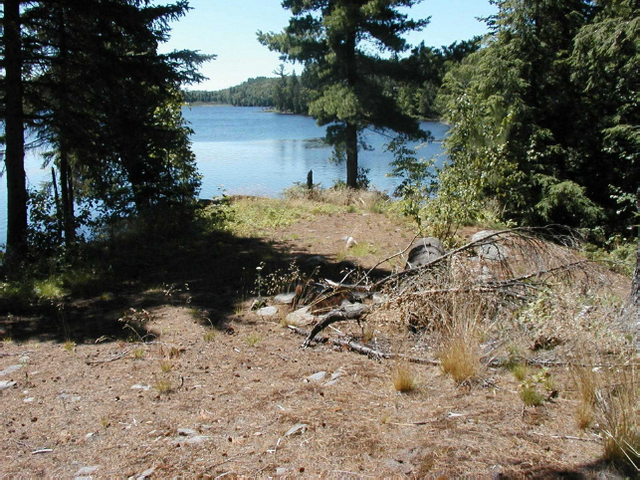
Photo 2: View northward into Mudcat Lake Forest Conservation Reserve across Mudcat Lake. Aquatic vegetation for moose feeding
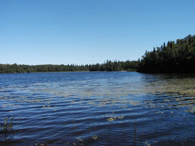
Photo 3: Gated private trail leading into Mudcat Lake Forest Conservation Reserve
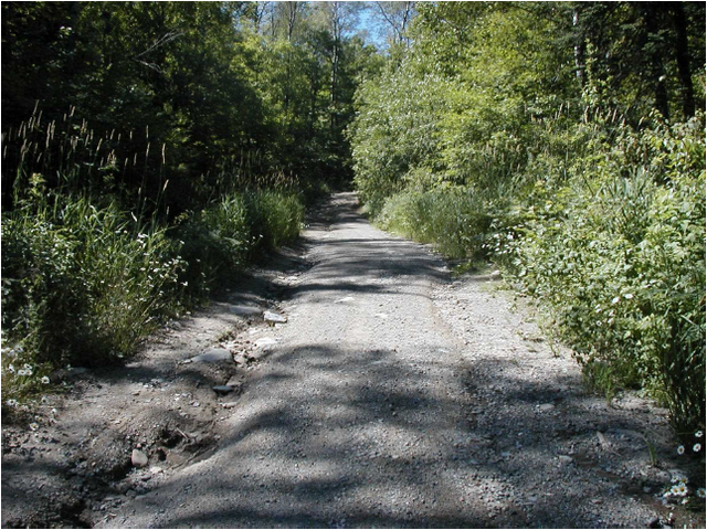
Photo 4: Exposed bedrock in Mudcat Lake Forest Conservation Reserve
Appendix 1 Procedural guideline B – Land Uses – Test of Compatibility (PL procedure 3.03.05)
The Conservation Reserve policy provides broad direction with regard to the permitted uses. The policy provides only an indication of the variety of uses that will be considered acceptable in conservation reserves. The only caution is that "any new uses, and commercial activities associated with them, will be considered on a case by case basis, and, they must pass a test of compatibility to be acceptable." What does a 'test of compatibility' mean?
An examination of this must start from the premise of why an area is set aside – specifically, its representative natural heritage values. Criteria are then identified to guide compatibility considerations. These criteria apply to the long-term acceptability of both existing uses and new uses.
-
Conformity to SCI/RMP: SCI describe values for which an area has been set aside and the range of appropriate uses that will be permitted in the area. SCI may also speak to the acceptability of other 'new' uses currently not occurring in the area.
The first 'test' is: "do proposed new land uses and/or commercial activities conform to the direction of the SCI/RMP for the conservation reserve? Would the new use(s) depart from the spirit of appropriate indicator land uses in the SCI/RMP?"
- Impact Assessment: If the proposed use(s) pass test 1 it is important to determine their impact on the area before they are approved. This should include the following:
- Impact on natural heritage values: "will the new use(s) impact any natural values in the area? If so how and to what degree? Is it tolerable?"
- Impact on cultural values: "will the new use(s) impact an historical or archaeological values in the area?"
- Impact on research activities: "will the new use(s) affect research activities in the area?"
- Impact on current uses: "will the new use(s) have any negative impact on the array of current uses?"
- Impact on area administration: "will the new use(s) increase administrative costs and/or complexity?" (For example, the cost of area monitoring, security and enforcement).
- Impact on accommodating the use outside the conservation reserve: "Could the use(s) be accommodated as well or better outside the conservation reserve?"
- Impact on socio-economics of the area: "will the new use(s) affect the community(ies) surrounding the area in a positive or negative way?" (For example, will the new use make an area less remote thereby affecting a local tourism industry that is dependent on the area’s remoteness for its appeal?"
- Impact on area accessibility: "does the new use(s) give someone exclusive rights to the area or a portion of the area to the exclusion of other existing uses?"
The following table provides a guide of indicator uses for the consideration of uses that may be permitted within conservation reserves. For any specific conservation reserve that test of compatibility should be applied to determine which specific uses are acceptable.
Appendix 2 - Public Lands Act Policy (3.03.05) Conservation Reserve
Permitted Use Table
Indicator Uses for Conservation Reserves
Recreation
| Permitted Activities | Generic Existing |
Generic New |
(C160) Specific New Uses |
|---|---|---|---|
| Sport fishing | Yes | Yes | Yes |
| Sport hunting | Yes | Yes | Yes |
| Food gathering | Yes | Yes | Yes |
| Facility infrastructure | Maybe | Maybe | Maybe1 |
| Non-trail snowmobiling | Maybe1 | Maybe1 | Maybe2 |
| Non-trail ATV use | Maybe1 | Maybe1 | Maybe2 |
| Rock climbing/caving | Maybe | Maybe | Not applicable |
| Canoeing/kayaking | Yes | Yes | Yes |
| Motorized boating | Yes | Yes | Yes |
| Picnicking | Yes | Yes | Yes |
| Camping | Maybe | Maybe | Yes |
| Trails | Yes | Maybe | Maybe1 |
| Hiking | Yes | Maybe | Maybe1 |
| X county skiing | Yes | Maybe | Maybe1 |
| Cycling | Yes | Maybe | Maybe1 |
| Horse riding | Yes | Maybe | Maybe1 |
| Snowmobiling | Yes | Maybe | Maybe1 |
1 New uses will be considered on a case by case basis provided they do not impact the natural heritage values for which the area was established, and must pass a test of compatibility to be acceptable.
2 For retrieval of game only.
Science, education & heritage appreciation
| Permitted Activities | Generic Existing |
Generic New |
(C160) Specific New Uses |
|---|---|---|---|
| Research | Yes | Yes | Yes |
| General walking | Yes | Yes | Yes |
| Photography and painting | Yes | Yes | Yes |
| Wildlife viewing | Yes | Yes | Yes |
| Outdoor education/interpretation | Yes | Yes | Yes |
| Collecting | No | No | No |
Commercial activities
| Permitted Activities | Generic Existing |
Generic New |
(C160) Specific New Uses |
|---|---|---|---|
| Food harvesting | Maybe | Maybe | No |
| Fishing | Maybe | Maybe | No |
| Baitfish harvesting | Yes1 | Maybe | Yes |
| Trapping | Yes1 | Maybe | Yes |
| Trap cabins | Yes | No | No |
| Resort-outpost camp | Yes1 | No | No |
| Outfitting-bear management | Yes1 | No | Yes |
| Wild rice harvesting | Yes | Maybe | Not applicable |
1 Transfer requests will be considered in the context of a Statement of Conservation Interest (SCI) or Resource Management Plan (RMP) for each conservation reserve.
Resource management
| Permitted Activities | Generic Existing |
Generic New |
(C160) Specific New Uses |
|---|---|---|---|
| Inventory monitoring | Yes | Yes | Yes |
| Featured species management | Maybe | Maybe | Maybe |
| Natural systems management | Maybe | Maybe | Maybe |
Industrial activities
| Permitted Activities | Generic Existing |
Generic New |
(C160) Specific New Uses |
|---|---|---|---|
| Timber harvesting | No | No | No |
| Prospecting | No | No | No |
| Mining | No | No | No |
| Hydro generation | No | No | No |
| Energy transmission corridors | Yes | No | No |
| Communications corridors | Yes | No | No |
| Transport corridors | Yes | No | No |
| Resource roads (MNR) | Yes | No | No |
| Land disposition | * | No | No |
| Hunt camps | Yes1 | No | No |
* Existing dispositions will continue, however, as opportunities arise the Ministry will acquire and/or remove them outside of the conservation reserve.
1 Transfer requests will be considered in the context of a Statement of Conservation Interest (SCI) or Resource Management Plan (RMP) for each conservation reserve.
Appendix 3 – Glossary of terms
Biotite: A generally black or dark green form of mica that is from crystalline rocks and consists of a silicate of iron, magnesium, potassium, and aluminum
Canadian Shield: One of the world’s largest, low relief areas in the Earths crust that are composed of Precambrian crystalline rock, centered on Hudson’s Bay and extending for 8,000,000 square km
Cultural Heritage: Collective term describing examples of a society’s evolution (e.g. history, anthropology and archaeology) worthy of study and preservation
Cultural Resources: Sites, features or artifacts related to the Province’s archaeology, anthropology or history, preserved in a natural setting
Ecodistrict: An ecological landscape unit (ranging in resolution in hundreds of square kilometers) characterized by a distinct patterns in landform
Ecoregion: An ecological landscape unit (ranging in resolution from hundreds of thousands to tens of thousands of square kilometers) characterized by distinct patterns of responses to climate as expressed by soils, hydrology, vegetation (species ranges and productivity), and fauna
Gneiss: A crystalline rock, consisting, like granite, of quartz, feldspar, and mica, but having these materials, especially the mica, arranged in planes, so that it breaks rather easily into coarse slabs or flags
Greywackes: Any of various dark gray sandstones that contain shale
Knob: Small prominent rounded hill or mountain of glacial drift
Lacustrine: Of or relating to lakes
Mast: The nuts of forest trees accumulated on the ground
Moraine: A knobby ridge either of (a) boulder clay built or by a thrust of a glacier or of (b) gravel and sand deposited at the edge of glacier escaping meltwater
OBM: Ontario Base Map, refers to a geographic division of Ontario according to lines of longitude into mapsheets based on the UTM map projection system
Overstory: The uppermost layer of foliage that forms a forest canopy
Patent: An exclusive right or title
Sedimentary: Of or relating to rocks formed by the deposition of sediment
Understory: An underlying layer of vegetation, especially the plants that grow beneath a forest’s canopy
UTM: Universal Transverse Mercator
Figure 1: Location map of Mudcat Lake Forest Conservation Reserve
Enlarge Figure 1: Location map of Mudcat Lake Forest Conservation Reserve
Figure 2: Forest values map of Mudcat Lake Forest Conservation Reserve
Enlarge Figure 2: Forest values map of Mudcat Lake Forest Conservation Reserve
Figure 3: Recreational values & tenure map of Mudcat Lake Forest Conservation Reserve

Enlarge Figure 3: Recreational values & tenure map of Mudcat Lake Forest Conservation Reserve
Footnotes
- footnote[3] Back to paragraph Merriam – Webster. 2002. Merriam – Webster Online. www.m-w.com.
- footnote[1] Back to paragraph Encyclopaedia Britannica, Inc. 2002. Encyclopaedia Britannica Online. www.britannica.com.
- footnote[5] Back to paragraph OMNR. 1992. Ontario Provincial Parks: Planning and Management Policies: 1992 Update. OMNR
- footnote[8] Back to paragraph Crins, William J and Peter W.C. Uhlig. 2002. Ecoregions of Ontario: Modifications to Angus Hills' Site Regions and Districts Revisions and Rationale.
- footnote[7] Back to paragraph OMNR. 1996. Forest Management Planning Manual. Toronto: Queen’s Printer for Ontario
- footnote[2] Back to paragraph Dictionary.com. 2003. Lexico Publishing Group. www.dictionary.com
- footnote[9] Back to paragraph Strahler, Alan and Arthur Strahler. 1997. Physical Geography Science and Systems of the Human Environment
- footnote[4] Back to paragraph Chapman, L.J, and D.F. Putnam. 1984. The Physiography of Southern Ontario, Third Edition. Ontario Geological Survey
- footnote[6] Back to paragraph OMNR. 2001. Glossary. http://www.mnr.gov.on.ca/mnr/forests/forestdoc/ebr/fimpdfs/glossary.pdf