Nahma Bog and Poor Fens Conservation Reserve Management Statement
This document provides policy direction for the protection, development and management of the Nahma Bog and Poor Fens Conservation Reserve and its resources.
C1598
Statement of Conservation Interest
December 2004
Cochrane District
Ministry of Natural Resources
Approval statement
I am pleased to approve this Statement of Conservation Interest (SCI) for the Nahma Bog and Poor Fens Conservation Reserve.
Direction for establishing, planning and managing conservation reserves is defined under the Public Lands Act, the Ontario’s Living Legacy Land Use Strategy, and other applicable policies. The specific direction for managing this conservation reserve is in the form of a basic SCI, which defines the area to which the plan applies, provides the purpose for which the conservation reserve has been proposed, and outlines the Ministry of Natural Resources' management intent for the protected area. This SCI has been created with input from program specialists within Cochrane District. It will provide both the foundation for continued monitoring of activities and guidance for managing the conservation reserve. More detailed direction at this time is not anticipated. However, should significant facility development be considered or complex issues arise requiring additional studies, more detailed management direction in the form of special protection measures, or a detailed Resource Management Plan, will be prepared with full public consultation.
This SCI will provide guidance for the management of the conservation reserve and the basis for the ongoing monitoring of activities. More detailed direction at this time is not anticipated. Should significant facility development be considered or complex issues arise requiring additional studies, more defined management direction, or special protection measures, a more detailed Conservation Reserve Management Plan will be prepared with full public consultation.
Public and Aboriginal consultation occurred prior to the regulation of this conservation reserve. Comments from the notification period have been considered in the development of this document.
The conservation reserve will be managed under the jurisdiction of the Cochrane Area Supervisor of the Ministry of Natural Resources, Cochrane District.
Plan Author:
Jennifer Telford
Resource Planner
Cochrane District
Approved by:
Ed Tear
District Manager
Original signed by Ed Tear
Date: March 15, 2005
Approved by:
Rob Galloway
Regional Director
Original signed by Rob Galloway
Date: April 5, 2005
1.0 Introduction
Ontario’s network of natural heritage areas has been established to protect and conserve areas representative of the diversity of the natural regions of the province, including species, habitats, features and ecological systems which comprise that natural diversity. Protected natural heritage areas are a key component in sustainable management of natural resources. They ensure that representative sites within the larger sustainable managed landscape are permanently retained in their natural state.
Natural Heritage areas are considered to be sensitive, requiring protection from incompatible activities if their values are to endure over time. The Ministry of Natural Resources (OMNR) has established conservation reserves as a new tool to offer protection for these areas on public lands, while permitting many traditional public land uses to continue. Such uses include the traditional activities of Aboriginal Peoples.
Ontario’s Living Legacy Land Use Strategy (OLL LUS) (OMNR 1999) as well as the Crown Land Use Policy Atlas sets the direction for the administration and management of parks and protected areas on Crown lands within three planning regions including: the Boreal West, Boreal East and Great Lakes – St. Lawrence areas. This strategy’s natural heritage objectives include protection of natural and cultural heritage values and the provision of opportunities for outdoor recreation, heritage appreciation and tourism (OMNR 1999).
Protected areas designated within the OLL LUS have been selected based on their representation of the spectrum of the province’s ecosystems and natural features including both biological and geological features, while minimizing impacts on other land uses. Representation was described using landform and vegetation combinations based on Hill’s (1959) ecodistrict concept.
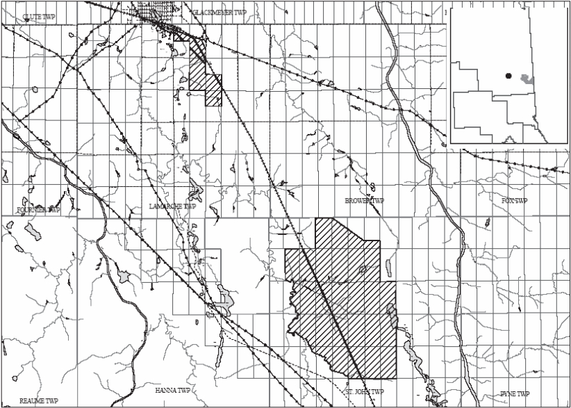
The Nahma Bog and Poor Fens Conservation Reserve is a 3606 ha parcel of crown land that is situated just south of the Town of Cochrane and is separated into two blocks. The north block is located in Lamarche Township while the second block is located in St. John Township. These townships are located in the Cochrane District within the MNR's Northeast Region. Public and Aboriginal consultation occurred prior to the regulation of this conservation reserve. The conservation reserve will be managed under a Statement of Conservation Interest (SCI).
SCI documents are the minimum level of management direction established for any conservation reserve and generally are brief management plans. This SCI will govern the lands and waters within the regulated boundary of the Nahma Bog and Poor Fens Conservation Reserve. However, to ensure MNR protection objectives are being fully met within the conservation reserve, the surrounding landscape and related activities should consider the site’s objectives and heritage values. In addition, it is the intent of the SCI to create public awareness that will promote responsible stewardship of protected areas and surrounding lands. With management partners such as Ontario Parks, industry and local governments, MNR District staff will be able to pursue and advance sound environmental, economic and social strategies and policies related to the protection of conservation reserves and provincial parks.
The purpose of this SCI is to identify and describe the values of the Nahma Bog and Poor Fens Conservation Reserve and outline the Ministry’s management intent for the conservation reserve. The management direction will protect the site’s natural heritage values and demonstrate its compatibility within the larger sustainable landscape. This direction will comply with land use intent as stated by the OLL Land Use Strategy (OMNR 1999).
2.0 Goals and objectives
2.1 Goal of Statement of Conservation Interest
The goal of this SCI is to describe and protect natural heritage values on public lands while permitting compatible land use strategies.
2.2 Objectives of SCI
2.2.1 Short term objectives
The short-term objectives are to identify the State of Resource with respect to natural heritage values and current land use activities for the Nahma Bog and Poor Fens Conservation Reserve. A priority will be placed on the protection of the site’s natural values via specific guidelines, strategies and prescriptions detailed in this plan. Finally, legislated planning requirements will be met (e.g. SCI development within three years of regulation).
2.2.2 Long term objectives
The long-term objectives will be able to establish representative targets (e.g. future forest conditions) and validate the site as a potential scientific benchmark. To ensure protection of natural and cultural heritage features and values, this SCI will establish an evaluation process to address future new uses and commercial activities associated with them (e.g. Test of Compatibility Procedural Guideline B in Conservation Reserve Policy PL 3.03.05). Finally, this SCI will identify research/client services and marketing strategies.
3.0 Management planning
3.1 Planning area
The planning area for this site will consist of the area within the regulated boundary for the Nahma Bog and Poor Fens Conservation Reserve. This landbase will form the area directly influenced by this SCI. The SCI will recognize the protection of values within the planning area; however, to fully protect values within the conservation reserve, the lands beyond the regulated boundary may require additional consideration within larger land use or resource management plans. Nevertheless, any strategies noted within this plan related to the site’s boundary or beyond will need to be presented for consideration within a larger planning context.
Figure 1: Nahma Bog and Poor Fens Conservation Reserve
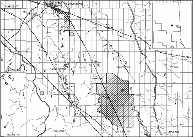
Enlarge Figure 1: Nahma Bog and Poor Fens Conservation Reserve
3.2 Management planning context
The Nahma Bog and Poor Fens Conservation Reserve was first designated as a candidate conservation reserve by MNR in the OLL Proposed Land Use Strategy (OMNR 1999) and ultimately as a conservation reserve in the final OLL Land Use Strategy (OMNR 1999). The site will be regulated with the filing of an Ontario Regulation made under the Public Lands Act. Management and planning direction for this site will follow the OLL LUS (OMNR 1999) and this management statement. The area encompassed by this site has also been removed from the Abitibi Consolidated Inc. Sustainable Forest License (SFL) landbase.
By regulation this conservation reserve cannot be used for commercial forest harvest, mining or hydroelectric power development (OMNR 1999). Existing permitted uses within this reserve may continue such as fishing, hunting and trapping. This SCI document and future management will continue to try and resolve conflicts regarding incompatibility between uses and to ensure that identified values are adequately protected.
This SCI will only address known issues or current proposals with respect to permitted uses or potential economic opportunities brought forward to the District Manager during this planning stage. However, in terms of approving future permitted uses and/or development(s), there are established mechanisms in place to address such proposals. Any future proposals will be reviewed using the Procedural Guideline B - Land Uses – Test of Compatibility Public Lands Act Policy PL 3.03.05 (OMNR 1997) or other standard MNR environmental screening processes.
Consideration of proposals pertaining to cultural resources may be screened through Conserving a Future for our Past: Archaeology, Land Use Planning & Development in Ontario, Section 3 (MCzCR 1997), or in processes such as that used by MNR to establish Area of Concern (AOC) descriptions and prescriptions for cultural heritage resources within forest management plans (FMPs).
These planning tools will help refine the review process once the proposal satisfies the direction and intent of the Public Lands Act, associated policies and this planning document.
3.3 Planning process
Once a conservation reserve is passed into regulation, it must be determined what level of management planning is required to fulfill the protection targets. There are two policy documents involved. A Statement of Conservation Interest (SCI) is the minimal requirement for providing planning direction, and a Resource Management Plan (RMP) that deals with more complex issues where several conflicting demands are placed on the resources. The guidelines for the preparation of these documents are outlined in Procedural Guideline A – Resource Management Planning (Conservation Reserves Procedure PL3.03.05 Public Lands Act). The appropriate plan must be completed within three years of the regulation date.
For current planning purposes, the Nahma Bog and Poor Fens Conservation Reserve will be managed under the auspices of a basic Statement of Conservation Interest. Interested parties from both the private and public sector were consulted during the OLL planning process from candidate conservation reserve to regulation. The public was widely consulted during the regulation process and further consultation is not required at this time. The intent of this SCI is to fulfil the commitments made within the OLL LUS (OMNR 1999).
The revised SCI was reviewed by the Cochrane District Manager (DM). Upon approval by the DM the SCI was presented to the Regional Director (RD) for final approval.
Following RD approval, interested public, user groups and industry were notified that the Statement of Conservation Interest for the Nahma Bog and Poor Fens Conservation Reserve was approved.
Public consultation will be solicited as part of any future reviews of land use proposals that would require new decisions to be made. In addition, any new significant management direction considered will be published on the Environmental Bill of Rights Registry (EBR).
The SCI is a basic planning document that will provide background information, identify values to be protected and establish management guidelines for use in the administration of the conservation reserve.
The implementation of the SCI will be the mandate of the MNR at the District level; however, associations with various partners may be sought to assist in the delivery. This SCI is a working document, and as a result, it may be necessary to make revisions to it from time to time.
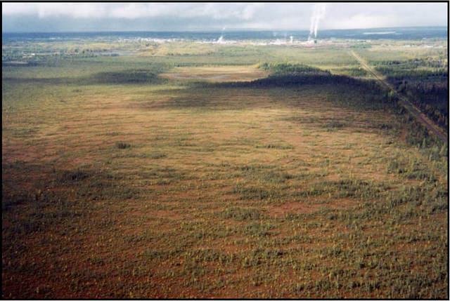
Figure 2: Nahma Bog with the Town of Cochrane in the background. Note the raised bog in the top center of the photo.
4.0 Background information
4.1 Location and site description
4.1.1 Location
The following table describes the location and provides administrative details of the Nahma Bog and Poor Fens Conservation Reserve:
Table 1: Location Data
| Name | Nahma Bog and Poor Fens (C1598) |
|---|---|
| Ecoregion – Ecodistrict (Hills 1959) | 3E (Lake Abitibi) - 3E-1 (Smokey Falls) |
| MNR Administrative Region/District Area | Northeast Region/Cochrane District in the Cochrane Area |
| Total Area | 3606 ha |
| UTM co-ordinates | 5075420 |
| Nearest Town/Municipality | Cochrane |
| Township(s) | Lamarche, St. John |
| OBM Numbers | 50541, 50542, 50543, 51541, 51542 |
| Topographical Map Name/Number | Iroquois Falls 42A/15 Abitibi 42H/2 |
| Wildlife Management Unit | |
| Forest Management Unit | Iroquois Falls |
4.1.2 Site description
4.1.2.1. Physical description
The Nahma Bog and Poor Fens Conservation Reserve consists of two blocks. The north block is located just outside of the Town of Cochrane in Lamarche Township and the south block is approximately 12 kilometres from Cochrane in St. John Township. The conservation reserve contains 3,606 hectares of land. The conservation reserve is located in the Smokey Falls Ecodistrict 3E-1 (Crins & Uhlig 2000), which is characterized by smooth plains of clay and loam over shallow to moderately deep bedrock with a high percentage of muskeg.
The site’s boundaries are a mixture of ecological, vectored and cultural. The north block is surrounded by patent land and is severed by the Ontario Northland Railway (ONR) right of way. The south block contains an ecological boundary in the form of the Wicklow River on the west side of the conservation reserve. The rest of the south blocks boundaries are vectored.
4.2 Administrative description
The legal boundaries of the Nahma Bog and Poor Fens Conservation Reserve will be filed with the Office of the Surveyor General, Ministry of Natural Resources in Peterborough, Ontario. This site is currently waiting to be passed into regulation.
4.3 History of site
Historically the site has been used for wildlife and recreation activities. The site contains portions of one Bear Management Area (CC-30-016), two active traplines (CC37, CC52) and three commercial bait harvest blocks. The site also has a portion of a snowmobile trail that runs through the north block. Most of the trail runs adjacent to the ONR right of way.
4.4 Inventories
The following table indicates the natural heritage inventory that has occurred or is required in the near future.
Table 2: Inventory Data
| Survey Level | Earth Science | Life Science | Cultural | Recreational | Other |
|---|---|---|---|---|---|
| Reconnaissance | September 2000 | September 2000 | Not required at this time | September 2000 | None |
| Detailed | August 2002 | October 2004 | January 2004 |
5.0 State of the Resource
Representation:
The Nahma Bog and Poor Fens Conservation Reserve is unique to the Cochrane District. The site is divided into two blocks. The north block is the Nahma Bog and the south block is the poor fens portion of the conservation reserve. The Nahma Bog is a historical Area of Natural and Scientific Interest (ANSI). The bog has many features that are unique to the area. Several of the features represented within the Nahma Bog are normally found in the Arctic.
The Nahma Bog contains a center raised bog, string bog, a basin fen and lagg swamps. The center raised bog is characterised by concentric contours of the surface and sub surface groundwater levels. The water moves from the center outward in all directions creating a patterned string bog of alternating shore treed bog ridges and swale habitats. (Jeglum) The basin fen is in the center of the north block and lagg swamps are found at the periphery of the site. A more detailed description of the wetland communities in the Nahma Bog is available in the Life Science Checksheet (Appendix #5).
The Nahma Bog and Poor Fens Conservation Reserve has a few rare species within it. Two rare plants were identified under the International Biological Programme (IBP) checksheet for the Nahma Bog. The checksheet lists Sphagnum pulchra and Sphagnum linbergii as being present within the bog. The IBP operated from 1964 to 1974 and it is unknown as to whether these two plants are still present in the bog. The bog lemming, a provincially rare mammal, was also found in the Nahma Bog. A great grey owl was observed in the site in 1991 during a site visit by the consulting firm Bird and Hale ltd. The great grey owl is currently listed as a species of Special Concern on Ontario’s Species at Risk list (OMNR 2004).
Geologically, the Nahma Bog and Poor Fens Conservation Reserve is underlain by organic deposits, glaciofluvial outwash deposits, glaciolacustrine deposits and till. The till can be found in the south block along with organic deposits and glaciolacustrine deposits. Iceberg keel marks were observed in the south block in the form of straight perpendicular creeks flowing into the Wicklow River. The north block is mainly organic deposits with some glaciofluvial outwash deposits (see Map 1b, Appendix# 5).
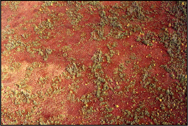
Figure 3: Red sphagnum moss.
The dominant forest type in the Nahma Bog and Poor Fens Conservation Reserve is dominant black spruce. Poplar, larch and cedar are also found within the conservation reserve. Since most of the site is bog, the forested areas are only found in a small percentage of the area in the north block and in a slightly larger percentage in the south block (Map 2a, Appendix #5).
Quality of representation:
The quality of the representation or the current characteristics of the natural features found within the conservation reserve are as important as the overall representative features that are being protected. A number of factors are considered in evaluating a site and they include the following criteria: diversity, condition, ecological factors, special features and current land use activities.
a) Diversity:
Diversity is a measure of the site’s life and earth science heterogeneity. The evaluation is based on the number and range (variety) of the natural landscape features and landforms for earth science values and the relative richness and evenness of the site’s life science components. Natural landscapes and known generalized vegetation communities will be the scale used for this SCI. Future aerial or ground reconnaissance surveys will enhance the MNR's knowledge of these features and possibly allow verification at a lower scale (e.g. species assemblages).
The diversity rating for the Nahma Bog and Poor Fens Conservation Reserve is medium. It is estimated to have between 25 and 30 landform:vegetation combinations. Standard Forest Units (SFU's) were used as well as the different wetland communities instead of the Forest Resource Inventory (FRI) wetlands. The conservation reserve has 16 different wetland communities and different age structures within the forest communities which add to the diversity and richness of the site. Old growth forest areas can be found in the south block of the conservation reserve.
The dominant landform:vegetation combinations are open bog/poor fen and semi-treed bog complex on organic deposits. Other landform:vegetation combinations include lowland black spruce and poplar on glaciolacustrine deposits and poplar on esker-kame complex.
b) Condition:
Condition is the degree of past human and natural disturbance observed or recorded for the site. The disturbance rating for the Nahma Bog and Poor Fens Conservation Reserve is medium. The disturbance in the conservation reserve is of human origin.
The north block has drainage ditches along the ONR line that could affect water levels in the wetland. An abandoned ONR spur line cuts through the north block and a snowmobile trail runs next to the railway line. The entire north block is surrounded by private land. Activities on private land that could affect the bog include aggregate extraction and draining wetlands for agriculture.
The south block has been affected by harvesting in the center of the site as well as around Gaffney Lake. The harvesting occurred in 1987/88 and the area was declared Free to Grow in 1998. A trail exists on the east side of Wicklow River and there is a cabin on Gaffney Lake. The south block is also split by the ONR right of way.
Figure 4: The ONR Railway in the south block of the conservation reserve.
c) Ecological factors:
Ecological factors refer to the current design of the conservation reserve as noted by its size, shape, and protection from adjacent land use activities.
The boundaries of the Nahma Bog and Poor Fens Conservation Reserve are a mixture of ecological, cultural and vectored. The north block is surrounded by patent land and is severed by the ONR right of way. These boundaries are all considered cultural. The south block has an ecological boundary along the west side in the form of the Wicklow River. The rest of the boundaries in the south block are vectored except for the ONR right of way which is a cultural boundary (History Map, Appendix #5).
The site is over 3000 hectares which is over the 2000 hectares considered necessary by Ontario Parks to protect representative landscapes as well as allow for low intensity recreation activities. The north block has little protection from adjacent land uses because of the patent land that surrounds it. There is little that can be done about this. The south block does not have good protection for its representative features either. The Ecological Considerations Map in Appendix #5 shows possible additions to the conservation reserve that may help to protect the wetland areas.
It is important to note that the bogs and fens of the Nahma Bog and Poor Fens Conservation Reserve act as a sink for atmospheric carbon dioxide. If these wetlands were drained the carbon would be released into the air adding to the greenhouse gases that are believed to cause global warming.
d) Special features:
The major features that are present within this conservation reserve include:
- The Nahma Bog which is considered a provincially significant wetland and is classed as an ANSI for being the most southerly bog of its type with arctic affinities.
- The two rare plants that have been identified in Nahma Bog; Sphagnum pulchra and Sphagnum linbergii.
- The bog lemming, a provincially rare mammal, was identified in the Nahma Bog.
- The importance of the bog and fens as a carbon sink.
e) Current land use activities
Land use activities associated with this site include hunting, fishing, trapping, and snowmobiling.
Summary:
The Nahma Bog and Poor Fens Conservation Reserve is a unique site with very diverse wetland communities. The Nahma Bog contains rare species and is a provincially significant wetland. It is an Area of Natural and Scientific Interest (ANSI) and was designated as a significant site under the International Biological Programme.
The conservation reserves string bog and raised bog are rare this far south as they are associated with the arctic. The site is very close to the Town of Cochrane and the north block which contains the Nahma Bog is entirely surrounded by patent land. The south block is further from the town and not as impacted by private land.
5.1 Social/economic interest in area
a) Linkage to local communities:
The Nahma Bog and Poor Fens Conservation Reserve is situated just south of the town of Cochrane and can be accessed using a trail near the east side of Wicklow River and by using the snowmobile trail that runs through the north block. The railway, which runs through the site, also potentially allows for additional access into the site.
b) Heritage estate contributions
The Nahma Bog and Poor Fens Conservation Reserve contributes to the province’s parks and protected areas system through its regulation, representation and the long-term management of natural heritage values. By allocating these lands to the parks and protected areas system, the province has ensured a certain level of permanence by distinguishing the site and its values from the broader general use or more extensively managed landscape. In addition, its natural features are, and will be available for present and future generations to enjoy and explore.
c) Aboriginal groups
The site is located within Taykwa Tagamou Nation’s area of interest.
d) Mining interests:
This conservation reserve has no mining tenure within it. Mining and surface rights have been withdrawn from staking within the conservation reserve’s boundaries under the Mining Act (RSO 1990 Chapter M.14).
e) Forest and fire management history:
This site has been affected by forest management activities. Harvesting has occurred in the middle of the south block and around Gaffney Lake. Harvesting took place in 1987/88 and therefore was done prior to the OLL Land Use Strategy (OMNR 1999) and the interim protection standards.
5.2 Natural heritage stewardship
Analysis of the life science targets based on landform:vegetation combinations has shown that the conservation reserve contains 25 to 30 landform:vegetation combinations. The analysis only considered landform:vegetation combinations that were over 50 hectares in size or that had unique features.
5.3 Fish and wildlife
There are two small lakes within the conservation reserve. Gaffney Lake was last surveyed in 1969 and Northern Pike was found at that time.
5.4 Cultural heritage stewardship
To date, a detailed assessment of cultural resources has not been carried out.
5.5 Land use/existing development
The conservation reserve is situated entirely on Crown Land. Two cottage/camp sites exist within the site; one on Gaffney Lake and one on Sak Creek near the railway line. Two trap cabins are also located within the site and legal agreements exist with registered trappers, bear management area operators and commercial bait operators. Mining and surface rights have been withdrawn from the reserve (MNDM G-Plan M-0282 December 12, 2001). The sale of lands within the conservation reserve is not permitted as per the OLL LUS (OMNR 1999). No new recreational camps will be permitted. Road realignments, telecommunications and other resource networks will be discouraged from crossing the site and interrupting the conservation reserve’s natural state. New roads for resource extraction and/or private use will not be permitted.
Through the Ministry’s plan input and review program, applications for more intense use will be reviewed to ensure natural heritage values within the conservation reserve are considered and protected in planning decisions on adjacent private land.
Any new developments (e.g. tourism developments) proposed for the conservation reserve must go through a Test of Compatibility to ensure that the activity is permitted and to ensure the natural heritage values within the site are protected. If a proposal is considered, public consultation may be required. If accepted, an amendment of the SCI would be required.
5.6 Commercial land use
Present commercial use activities include one bear management area (CC-30-016), two active traplines (CC37, CC52) and three commercial bait harvesting operations. (Map 3a, Appendix #5)
Conservation reserves do not permit mining, commercial forest harvesting, hydroelectric power development, or the extraction of peat, soils, or other industrial uses (Public Lands Act, Ontario Regulation 805/94). Other new commercial activities must meet the requirements of Procedural Guideline B – Test of Compatibility.
5.7 Tourism/recreation use/opportunities
Some of the features within the site associated with possible recreational use include wetlands and trails. Existing recreational uses in this site and immediately surrounding the site include trapping, hunting, and snowmobiling. There is also potential for activities such as bird watching and nature study.
For a more detailed report and summary of the recreational use and potential, refer to the Recreational Inventory Check-Sheet (Appendix #1).
Figure 5: The railway and adjacent snowmobile trail (on left side of railway).
5.8 Client services
Currently, visitor services are limited to responding to inquiries about access, natural heritage features and boundaries. No formal information or interpretive facilities currently exist within the conservation reserve. Other client services include providing clients with maps, fact sheets, and other information gathered on the area, such as the Earth/Life Sciences and Recreational inventory work.
6.0 Management guidelines
6.1 Management planning strategies
The land use intent outlined in the OLL LUS (OMNR 1999) provides context and direction to land use, resource management, and operational planning activities on Crown Land in the planning area and within OLL site boundaries. Commitments identified in the OLL LUS and current legislation (Policy 3.03.05 PLA) forms the basis for land use within the Nahma Bog and Poor Fens Conservation Reserve. Management strategies for these uses must consider the short and long-term objectives for the conservation reserve. For up to date information on permitted uses refer to the Crown Land Use Atlas (OMNR 2002) (/page/crown-land-use-policy-atlas).
Proposed new uses and development will be reviewed on a case-by-case basis. A Test of Compatibility, (Procedural Guideline B – Land Uses (PL 3.30.05)) must be completed before proposals can be accepted. In all cases, ensuring that the natural values of the conservation reserve are not negatively affected by current and future activities will be the priority. Therefore any application for new specific uses will be carefully studied and reviewed.
6.2 "State of the Resource" management strategies
The development of this SCI and the long term management and protection of the Nahma Bog and Poor Fens Conservation Reserve will be under the direction of the MNR's Cochrane District, Cochrane Area Supervisor. The following management strategies have been created to achieve the goal and objectives stated earlier in this management document.
Natural heritage stewardship
The management intent for Nahma Bog and Poor Fens Conservation Reserve is to allow for natural ecosystems, processes and features to operate undisturbed with minimal human interference while providing educational, research and recreational activities. Forest ecosystem renewal will only be entertained via a separate vegetation management plan. As part of any future vegetation management plan the site and its ecodistrict will be re-evaluated with respect to their known landform/vegetation features to determine if the past harvested areas could contribute additional landform/vegetation values to the ecodistrict.
In addition, the vegetation management plan will need to determine but not be limited to:
- the restoration ecology objectives (e.g. representation) for the area in context with the ecodistrict;
- consider current provincial strategies (e.g. white pine);
- consider larger long-term conservation reserve (e.g. recreational objectives) and possibly landscape objectives (e.g. contributions to landscape wildlife objectives).
The MNR recognizes fire as an essential process fundamental to the ecological integrity of conservation reserves. In accordance with existing Conservation Reserve Policy and the Forest Fire Management Strategy for Ontario, forest fire protection will be carried out as on surrounding lands.
Whenever feasible, the MNR fire program will endeavour to use "light on the land" techniques, which do not unduly disturb the landscape, in this conservation reserve. Examples of light on the land techniques may include limiting the use of heavy equipment or limiting the number of trees felled during fire response efforts.
Opportunities for prescribed burning to achieve ecological or resource management objectives may be considered. These management objectives will be developed with public consultation prior to any prescribed burning, and reflected in the document that provides management direction for this conservation reserve. Plans for any prescribed burning will be developed in accordance with the MNR Prescribed Burn Planning Manual, and the Class Environmental Assessment for Provincial Parks and Conservation Reserves. Defining compatible uses, enforcing regulations and monitoring and mitigating issues will protect all earth and life science features. Industrial activities such as traditional commercial timber harvest (e.g. logging), non-traditional forest harvest (e.g. Canada Yew harvesting), and new hydro generation will not be permitted within the conservation reserve. Permits for fuel-wood will not be issued. New energy transmission, communication and transportation corridors or construction of facilities within the boundaries of the conservation reserve would be subject to a Test of Compatibility. The current policy is to discourage new energy transmissions, communication and transportation corridors as such structures negatively impact the quality of the representative features that require protection. However, it is recognized that the Nahma Bog and Poor Fens Conservation Reserve is already impacted by such structures and upgrades to existing facilities or the construction of new facilities may be required in the future. Alternatives should be reviewed via larger landscape planning processes. New roads for resource extraction will not be permitted. Other activities that do not pass a Test of Compatibility will be prohibited (OMNR Policy 3.03.05, 1997).
The introduction of exotic and/or invasive species will not be permitted. Programs may be developed to control forest insects and diseases where they threaten significant heritage, aesthetic, or economic values. Where control is desirable, it will be directed as narrowly as possible to the specific insect or disease. Biological or non-intrusive solutions should be applied whenever possible.
The collection/removal of vegetation and parts thereof will not be permitted; however, subject to a Test of Compatibility, the Area Supervisor may authorize such activities for purposes of rehabilitating degraded sites within the reserve, collecting seeds for maintaining genetic stock and/or for inventory or research purposes.
The MNR will provide leadership and direction for maintaining the integrity of this site as a heritage estate. To ensure MNR protection objectives are fully met within the conservation reserve, activities on the surrounding landscape must consider the site’s objectives and heritage values. Research, education and interpretation will be encouraged to provide a better understanding of the management and protection of the natural heritage values and will be fostered through local and regional natural heritage programs, initiatives and partnerships.
The conservation reserve will be managed by allowing natural ecosystems, processes, and features to function normally, with minimal human interference.
Fish and wildlife
Fish and wildlife resources will continue to be managed in accordance with specific policies and regulations defined by the Ontario Ministry of Natural Resources under the Fish and Wildlife Conservation Act and the Cochrane District, Cochrane Area Supervisor.
Fishing and hunting is expected to continue at a low level of intensity. Any future trail development will require a Test of Compatibility.
Cultural heritage
When possible, the Ministry of Natural Resources will continue to work with the Ontario Ministry of Culture, Tourism and Recreation in identifying archaeological sites to be protected. To more fully manage and protect sites, the development of field surveys would be required. However, at this time additional field surveys within the conservation reserve are not recommended.
Development, research and education proposals may be considered in accordance with the Test of Compatibility and Conserving a Future for our Past: Archaeology, Land Use Planning & Development in Ontario, Section 3 (MCzCR, 1997).
Land use and development
The sale of lands within the conservation reserve is not permitted as per the OLL LUS (OMNR, 1999). Existing authorized trails can continue to be used and maintained, unless there are significant demonstrated conflicts. New trails will only be allowed if a Test of Compatibility is passed. Any new trail development will require an amendment to the SCI. The cutting of trees for non-commercial purposes (e.g. fuelwood) is not permitted except as required for approved development activity (e.g. trail, viewing site, etc.). New roads for resource extraction will not be permitted. Abandoned forest extraction roads will not be actively maintained.
There is one Land Use Permit within the south block of the conservation reserve for a cabin on Gaffney Lake. There are no other forms of tenure in the conservation reserve other than legal agreements with registered trappers, bear management area operators and commercial bait operators.
Traditional uses within the conservation reserve will continue to be permitted; however, the goal will be to resolve conflicts regarding incompatibility between uses and to ensure that identified values are adequately protected.
Commercial use
All existing commercial bait fishing and commercial bear hunting (within BMAs) operations are permitted to continue. The introduction of new commercial bear hunting operations will not be allowed. The issuance of licenses to provide bear hunting services will be allowed where areas have been licensed or authorized under agreement for the activity since January 1, 1992.
Existing commercial fur harvesting operations are permitted to continue. New operations may be considered subject to a Test of Compatibility.
Aboriginal interests
The Nahma Bog and Poor Fens Conservation Reserve is within the Taykwa Tagamou Nation’s areas of interest. Aboriginal and treaty rights will continue to be respected throughout the management of this conservation reserve. Any future proposal(s) and or decision(s) that have potential impact(s) on individual aboriginal values and or communities will involve additional consultation with the affected aboriginal groups.
Tourism/recreation
The earth and life science features and their protection shall be the overall theme for tourism. Small-scale infrastructures for enhancing tourism and recreation (i.e., warm-up shelter) may be considered, providing they pass a Test of Compatibility and other MNR requirements.
Most recreational activities that have traditionally been enjoyed in the area can continue provided they pose no threat to the natural ecosystems and features protected by the conservation reserve. These permitted activities include walking, hiking, wildlife viewing, fishing, hunting, snow shoeing, and cross-country skiing.
Snowmobiles and All-Terrain Vehicles (ATVs) are permitted on existing trails and forest access roads within the conservation reserve. Under the OLL LUS (OMNR 1999), all mechanized travel is restricted to existing trails. Off trail vehicle use is permitted for the retrieval of game only. The use of existing trails, within the Nahma Bog and Poor Fens Conservation Reserve, does not degrade the values in the site.
Existing trails for hiking, snowmobiling, ATV use, cycling, horseback riding and cross-country skiing can continue. To ensure the quality of the representation is maintained, all trails and old forest access roads within the site should be identified via new technologies (i.e. GPS) to ensure a record of these features exists. New trails can be considered through a Test of Compatibility.
Finally, conflict resolution between recreational uses will be a priority. This will be achieved by adhering to the objectives of this SCI with input from relevant user groups. The level of safety and compatibility between activities will determine permitted uses (i.e. Test of Compatibility).
Client services
Clients indicating their interest in the management, planning and future use of this conservation reserve will be put on a mailing list and notified of any future planning concerning the site.
Present client services such as supplying maps, fact sheets and other information will also continue. Information may be delivered from different sources; however, MNR will be the lead agency for responding to inquiries regarding access, permitted and restricted activities, values and recreation opportunities. A management agreement may be pursued with an appropriate partner to share responsibilities for information services and the delivery of other aspects of this SCI in the future.
6.3 Specific feature/area/zone management strategies
There are no specific management strategies for the maintenance/protection/enhancement of selected resources within the conservation reserve. Development of such strategies will require an amendment to the SCI.
6.4 Promote Inventory, Monitoring and Assessment Reporting (IMAR), and research
Scientific research by qualified individuals, which contributes to the knowledge of the natural and cultural history, and to environmental and recreational management, will be encouraged.
Additional life science inventory or research is required at this time to refine values and features. Research related to the study of natural processes will be encouraged provided it does not harm the values of the reserve. The Cochrane Area Supervisor or District Manager may approve the removal of any natural or cultural specimen by qualified researchers. All such materials removed remain the property of the Ministry of Natural Resources. All research programs will require the approval of the Ministry of Natural Resources and will be subject to Ministry policy and other legislation.
New research developments such as campsites, privies, trails or developed access points or activities will not be considered until a Test of Compatibility is conducted and the proposal is approved by the Cochrane Area Supervisor or District Manager. The Test of Compatibility or environmental screening process could include a review of the demand for structures or activities and may require more detailed life or earth science or cultural information and possibly more detailed management plan.
Approved research activities and facilities will be compatible with the site’s protection objective. Permanent plots or observation stations may be established to which researchers can return over time. Any site that is disturbed will be rehabilitated as closely as possible to its original state.
6.5 Implementation, and plan review strategies
The Nahma Bog and Poor Fens Conservation Reserve SCI will be reviewed on an ongoing basis and as required.
Implementation of the SCI and management of the reserve is the responsibility of the Cochrane Area Supervisor. Partnerships may be pursued to address management needs.
If changes in management direction are needed at any time, the significance of the changes will be evaluated. Minor changes that do not alter the overall protection objectives may be considered and approved by the District Manager without further public consultation and the plan will be amended accordingly. In assessing major changes, the need for a more detailed Resource Management Plan will first be considered. Where a Resource Management Plan is not considered necessary or feasible, a major amendment to this SCI may be considered with public consultation. The Regional Director must approve major amendments.
6.6 Marketing strategies
The Nahma Bog and Poor Fens Conservation Reserve will be marketed as a representative natural area having earth and life science values, as well as certain recreational values. Marketing efforts to increase use are not a priority and will be kept to a minimum.
6.7 Boundary identification
There is no stated policy to mark the boundaries of a conservation reserve.
Local management discretion can be used to determine where boundary marking may be appropriate. In order for restrictions to be enforceable, signs must be placed in accordance with the Trespass to Property Act or subsection 28 (1) of the Public Lands Act to advise against any recreational activities.
7.0 References
Bird and Hale Limited, 1992. A Biological Inventory of Nahma Bog. Area of Natural and Scientific Interest.
Boissonneau, A.N., 1968. Timiskaming and Nipissing, Surficial Geology; Cartography by Lands and Surveys Branch.
Burkhardt, B., King, L., and Schultz, A. 2004. Natural Heritage Area – Life Science Checksheet (C1598).
Chamber, B.A., Naylor, B.J., Niepoller,J., Merchant, B., and Uhlig, P. 1997. Field Guide to Forest Ecosystems of Central Ontario.
Crins, W.J. and P.W.C. Uhlig. 2000. Ecoregions of Ontario: Modifications to Angust Hill’s Site Regions and Site Districts – Revisions and Rationale.
Geomatics International. 1994. CCEA Case Studies on Ecoregions Gary Analysis: Proposed Methodology for Determination of Representatives. Report prepared for the Canadian Council on Ecological Areas.
Hills, G.A. 1959a. A Ready Reference to the Description of the Land of Ontario and its Productivity.
Hills, G.A. 1959b. Hills Mapping.
Jeglum, J. K., Adams, P.W., Warner, B., Davies, C. A Concentric, Centre Raised Bog.
Kor, P.S.G. 2002. Earth Science Inventory Checklist – Pinard Moraine Conservation Reserve (C1582).
NTS topographic mapping (42A/15 and 42H/2).
OFRI. 1994a. Boreal East Landforms Mapping – Satellite Imagery.
Ontario Ministry of Citizenship, Culture and Recreation. 1997. Conserving a Future for Our Past: Archaeology, Land Use Planning & Development in Ontario
Ontario Ministry of Natural Resources. 1:20 000 1994 Air Photos.
Ontario Ministry of Natural Resources. 1995. Forest Resource Inventory Mapping (Ages Corrected).
Ontario Ministry of Natural Resources. 1997c. Ontario Watershed Mapping.
Ontario Ministry of Natural Resources. 2004 Ontario’s Species at Risk list
Ontario Ministry of Natural Resources. Lakes 1:600 000 Mapping.
Ontario Ministry of Natural Resources. MTO Roads 1:600 000 Mapping.
Ontario Ministry of Natural Resources. Patent 1:600 000 Mapping.
Ontario Ministry of Natural Resources. Railway 1:600 000 Mapping.
Ontario Ministry of Natural Resources. Townships 1:600 000 Mapping.
Ontario Ministry of Natural Resources. Transmission Lines 1:600 000 Mapping.
Ontario Ministry of Natural Resources Sault Ste. Marie District. 2001. C289 Searchmount South Forest Conservation Reserve.
Poser, S. 1992. Report of the status of provincial parks in the site region and districts of Ontario. Ministry of Natural Resources Report.
Rowe, J.S. 1972. Forest Regions of Canada.
Appendix 1: Recreation inventory check sheet
Appendix 2: Procedural guideline B – Land uses – Test of Compatibility (PL 3.03.03)
The Conservation Reserve policy provides broad direction with regard to the permitted uses. The policy provides only an indication of the variety of uses that will be considered acceptable in conservation reserves. Any new uses, and commercial activities associated with them, will be considered on a case by case basis, and, subject to the following test of compatibility. To ensure a standard screening process is followed, reviews of all current and new activities will be subject to the screening criteria as specified by the Environmental Assessment Act (R.S.O. 1900, Chapter E.18).
The following outlines the two steps involved in performing a Test of Compatibility. An assessment of current activities would only follow step two, which focuses on the impacts. An assessment of any new activity would consider the impact of the activity and its conformity to the SCI/RMP.
-
Conformity to SCI/RMP: SCI describe values for which an area has been set aside and the range of appropriate uses that will be permitted in the area. SCI may also speak to the acceptability of other 'new' uses currently not occurring in the area.
The first 'test' is: "do proposed new land uses and/or commercial activities conform to the direction of the SCI/RMP for the conservation reserve? Would the new use(s) depart from the spirit of appropriate indicator land uses in the SCI/RMP?"
- Impact Assessment: If the proposed use(s) pass test 1 it is important to determine their impact on the area before they are approved. This should include the following:
- Impact on natural heritage values: "will the new use(s) impact any natural values in the area? If so how and to what degree? Is it tolerable?"
- Impact on cultural values: "will the new use(s) impact an historical or archaeological values in the area?"
- Impact on research activities: "will the new use(s) affect research activities in the area?"
- Impact on current uses: "will the new use(s) have any negative impact on the array of current uses?"
- Impact on area administration: "will the new use(s) increase administrative costs and/or complexity?" (For example, the cost of area monitoring, security and enforcement).
- Impact on accommodating the use outside the conservation reserve: "Could the use(s) be accommodated as well or better outside the conservation reserve?"
- Impact on socio-economics of the area: "will the new use(s) affect the community(ies) surrounding the area in a positive or negative way?" (For example, will the new use make an area less remote thereby affecting a local tourism industry that is dependent on the area’s remoteness for its appeal?"
- Impact on area accessibility: "does the new use(s) give someone exclusive rights to the area or a portion of the area to the exclusion of other existing uses?"
Appendix 3: Procedural Guideline C – Research Activities in Conservation Reserves
Purpose
To encourage contributions to the goal of the conservation reserves by:
- Providing direction for research activities associated with the conservation reserves; and
- Establishing a process for the review and approval of proposals by researchers, which could have an impact on the values protected by the conservation reserve
Definition
Research means any investigation or study of the natural, cultural, social, economic, management or other features or characteristics of conservations reserves.
Guidelines
Research will be encouraged to provide a better understanding of the natural values protected by a conservation reserve and to advance their protection, planning and management.
The Statement of Conservation Interest will define, for each conservation reserve, the key research issues, set out the parameters within which research may occur and identify research needs.
Applications and approvals
Researchers must apply in writing to the Area Supervisor for permission to conduct research. The request letter must contain a statement explaining why the proposed research should be undertaken in the particular conservation reserve in preference to another location.
Proposals will be reviewed and approved by the Area Supervisor, guided by the Statement of Conservation Interest prepared for each reserve, including adherence to the Test of Compatibility. Permission must be granted in writing, including any conditions to be met in conducting the research prior to the undertaking of any research project.
Terms and conditions
Permission to conduct research under this policy will be valid for a period of 12 consecutive months from date of issue. Permission to continue a research project for addition periods of 12 months or less may be granted upon submission of a written request and progress report. The Ministry may require the posting of collateral to assure that the terms and conditions of granting permission are met.
The Area supervisor may suspend or revoke permission at any time for failure on the part of the researcher to meet:
- The intent or conditions of this policy
- The requirements under the Public Lands Act, including all amendments, where applicable
- The requirements under any other Act or Regulations of Ontario or Canada, including those governing the taking, handling, storing, confining, trapping, excavating and marketing any specimen, artefact, information or action (for example, scientific collector’s permit)
- The condition and agreement specified in granting permission.
Final report
The researcher will submit copies of reports, publication and theses following from the results of the project to the Area Supervisor.
Appendix 4: Crown Land Use Atlas – Policy Report
Appendix 5: Natural Heritage - Life Science Check Sheet
Appendix 6: Earth Science Check-Sheet
A7 SCI Amendments
Amendment #1
Section: 4.2 Administrative Description
Type: Administrative
Reason for amendment: Site has officially been regulated
Date: May 11, 2005
Section 4.2 should now read:
The Nahma Bog and Poor Fens Conservation Reserve was regulated as schedule 261 of Ontario Regulation 181/05 made under the Public Lands Act on April 20, 2003 and filed April 21, 2005, amending Ontario Regulation 805/94. The legal description as found in the May 7th, 2005 edition of the Ontario Gazette, reads as follows:
In the geographic Township of Lamarche, now in the Town of Cochrane, and in the geographic Township of St. John, in the Territorial District of Cochrane, containing 3,606 hectares, more or less, being composed of those parts of the said geographic townships designated as Parts 1 to 9, both inclusive, on a Plan known as C1598 Nahma Bog And Poor Fens Conservation Reserve, filed on April 14, 2004, with the Office of the Surveyor General of Ontario in the Ministry of Natural Resources.
The official Ontario Gazette amendment is available on the internet at http://www.ontariogazette.gov.on.ca/.