Northern Madtom Recovery Strategy
This document advises the ministry on ways to ensure healthy numbers of the Northern Madtom, a threatened or endangered species, return to Ontario.
Northern Madtom (Noturus stigmosus) in Ontario
Ontario Recovery Strategy Series
Recovery strategy prepared under the Endangered Species Act, 2007
2013
Ministry of Natural Resources
About the Ontario Recovery Strategy Series
This series presents the collection of recovery strategies that are prepared or adopted as advice to the Province of Ontario on the recommended approach to recover species at risk. The Province ensures the preparation of recovery strategies to meet its commitments to recover species at risk under the Endangered Species Act (ESA) and the Accord for the Protection of Species at Risk in Canada.
What is recovery?
Recovery of species at risk is the process by which the decline of an endangered, threatened, or extirpated species is arrested or reversed, and threats are removed or reduced to improve the likelihood of a species' persistence in the wild.
What is a recovery strategy?
Under the ESA a recovery strategy provides the best available scientific knowledge on what is required to achieve recovery of a species. A recovery strategy outlines the habitat needs and the threats to the survival and recovery of the species. It also makes recommendations on the objectives for protection and recovery, the approaches to achieve those objectives, and the area that should be considered in the development of a habitat regulation. Sections 11 to 15 of the ESA outline the required content and timelines for developing recovery strategies published in this series.
Recovery strategies are required to be prepared for endangered and threatened species within one or two years respectively of the species being added to the Species at Risk in Ontario list. There is a transition period of five years (until June 30, 2013) to develop recovery strategies for those species listed as endangered or threatened in the schedules of the ESA. Recovery strategies are required to be prepared for extirpated species only if reintroduction is considered feasible.
What’s next?
Nine months after the completion of a recovery strategy a government response statement will be published which summarizes the actions that the Government of Ontario intends to take in response to the strategy.
The implementation of recovery strategies depends on the continued cooperation and actions of government agencies, individuals, communities, land users, and conservationists.
For more information
To learn more about species at risk recovery in Ontario, please visit the Ministry of Natural Resources Species at Risk webpage at: www.ontario.ca/speciesatrisk
Recommended citation
Ontario Ministry of Natural Resources. 2013. Recovery Strategy for the Northern Madtom (Noturus stigmosus) in Ontario. Ontario Recovery Strategy Series. Ontario Ministry of Natural Resources, Peterborough, Ontario. iii + 5 pp. + Appendix viii + 43 pp. Adoption of the Recovery Strategy for the Northern Madtom (Noturus stigmosus) in Canada (Edwards et al. 2012).
Cover illustration: Illustration by Joseph R. Tomelleri
© Queen’s Printer for Ontario, 2013
ISBN 978-1-4606-3061-7 (PDF)
Content (excluding the cover illustration) may be used without permission, with appropriate credit to the source.
Cette n hautement spécialisée « Recovery strategies prepared under the Endangered Species Act, 2007 », n'est disponible qu'en Anglais en vertu du Règlement 411/97 qui en exempte l'application de la Loi sur les services en français. Pour obtenir de l'aide en français, veuillez communiquer avec Pamela Wesley au ministère des Richesses naturelles au 705 755-5217.
Declaration
The recovery strategy for the Northern Madtom was developed in accordance with the requirements of the Endangered Species Act, 2007 (ESA). This recovery strategy has been prepared as advice to the Government of Ontario, other responsible jurisdictions and the many different constituencies that may be involved in recovering the species.
The recovery strategy does not necessarily represent the views of all of the individuals who provided advice or contributed to its preparation, or the official positions of the organizations with which the individuals are associated.
The goals, objectives and recovery approaches identified in the strategy are based on the best available knowledge and are subject to revision as new information becomes available. Implementation of this strategy is subject to appropriations, priorities and budgetary constraints of the participating jurisdictions and organizations.
Success in the recovery of this species depends on the commitment and cooperation of many different constituencies that will be involved in implementing the directions set out in this strategy.
Responsible jurisdictions
Ontario Ministry of Natural Resources
Fisheries and Oceans Canada
Adoption of recovery strategy
The Endangered Species Act, 2007 (ESA) requires the Minister of Natural Resources to ensure recovery strategies are prepared for all species listed as endangered or threatened on the Species at Risk in Ontario (SARO) List. Under the ESA, a recovery strategy may incorporate all or part of an existing plan that relates to the species.
The Northern Madtom (Noturus stigmosus) is listed as endangered on the SARO List. The species is also listed as endangered under the federal Species at Risk Act (SARA). Fisheries and Oceans Canada prepared the Recovery Strategy for the Northern Madtom in Canada in June, 2012 to meet its requirements under the SARA. This recovery strategy is hereby adopted under the ESA. With the additions indicated below, the enclosed strategy meets all of the content requirements outlined in the ESA.
Species assessment and classification
Common name: Northern Madtom
Scientific name: Noturus stigmosus
SARO List Classification: Endangered
SARO List History: Endangered (2004)
COSEWIC Assessment History: Endangered (2012, 2002), Special Concern (1998)
SARA Schedule 1: Endangered (January 12, 2005)
Conservation status rankings: GRANK: G3 NRANK: N1 SRANK: S1
The glossary provides definitions for technical terms, including the abbreviations above.
Area for consideration in developing a habitat regulation
Under the ESA, a recovery strategy must include a recommendation to the Minister of Natural Resources on the area that should be considered in developing a habitat regulation. A habitat regulation is a legal instrument that prescribes an area that will be protected as the habitat of the species. The recommendation provided below will be one of many sources considered by the Minister when developing the habitat regulation for this species.
Section 2.7 of the federal recovery strategy provides an identification of critical habitat (as defined under the SARA). Identification of critical habitat is not a component of a recovery strategy prepared under the ESA. However, it is recommended that the approach used to identify critical habitat in Section 2.7 be considered when developing a habitat regulation under the ESA.
Glossary
Committee on the Status of Endangered Wildlife in Canada (COSEWIC): The committee established under section 14 of the Species at Risk Act that is responsible for assessing and classifying species at risk in Canada.
Committee on the Status of Species at Risk in Ontario (COSSARO): The committee established under section 3 of the Endangered Species Act, 2007 that is responsible for assessing and classifying species at risk in Ontario.
Conservation status rank: A rank assigned to a species or ecological community that primarily conveys the degree of rarity of the species or community at the global (G), national (N) or subnational (S) level. These ranks, termed G-rank, N-rank and S-rank, are not legal designations. The conservation status of a species or ecosystem is designated by a number from 1 to 5, preceded by the letter G, N or S reflecting the appropriate geographic scale of the assessment. The numbers mean the following:
1 = critically imperilled
2 = imperilled
3 = vulnerable
4 = apparently secure
5 = secure
Endangered Species Act, 2007 (ESA): The provincial legislation that provides protection to species at risk in Ontario.
Species at Risk Act (SARA): The federal legislation that provides protection to species at risk in Canada. This act establishes Schedule 1 as the legal list of wildlife species at risk. Schedules 2 and 3 contain lists of species that at the time the Act came into force needed to be reassessed. After species on Schedule 2 and 3 are reassessed and found to be at risk, they undergo the SARA listing process to be included in Schedule 1.
Species at Risk in Ontario (SARO) List: The regulation made under section 7 of the Endangered Species Act, 2007 that provides the official status classification of species at risk in Ontario. This list was first published in 2004 as a policy and became a regulation in 2008.
Appendix 1 - Recovery Strategy for the Northern Madtom (Noturus stigmosus) in Canada
Species at Risk Act
Recovery Strategy Series
Recovery Strategy for the Northern Madtom (Noturus stigmosus) in Canada
Northern Madtom
2012
About the Species at Risk Act Recovery Strategy Series
What is the Species at Risk Act (SARA)?
SARA is the Act developed by the federal government as a key contribution to the common national effort to protect and conserve species at risk in Canada. SARA came into force in 2003 and one of its purposes is "to provide for the recovery of wildlife species that are extirpated, endangered or threatened as a result of human activity."
What is recovery?
In the context of species at risk conservation, recovery is the process by which the decline of an endangered, threatened, or extirpated species is arrested or reversed and threats are removed or reduced to improve the likelihood of the species' persistence in the wild. A species will be considered recovered when its long-term persistence in the wild has been secured.
What is a recovery strategy?
A recovery strategy is a planning document that identifies what needs to be done to arrest or reverse the decline of a species. It sets goals and objectives and identifies the main areas of activities to be undertaken. Detailed planning is done at the action plan stage.
Recovery strategy development is a commitment of all provinces and territories and of three federal agencies — Environment Canada, Parks Canada Agency, and Fisheries and Oceans Canada — under the Accord for the Protection of Species at Risk. Sections 37–46 of SARA outline both the required content and the process for developing recovery strategies published in this series.
Depending on the status of the species and when it was assessed, a recovery strategy has to be developed within one to two years after the species is added to the List of Wildlife Species at Risk. Three to four years is allowed for those species that were automatically listed when SARA came into force.
What’s next?
In most cases, one or more action plans will be developed to define and guide implementation of the recovery strategy. Nevertheless, directions set in the recovery strategy are sufficient to begin involving communities, land users, and conservationists in recovery implementation. Cost-effective measures to prevent the reduction or loss of the species should not be postponed for lack of full scientific certainty.
The series
This series presents the recovery strategies prepared or adopted by the federal government under SARA. New documents will be added regularly as species get listed and as strategies are updated.
To learn more
To learn more about the Species at Risk Act and recovery initiatives, please consult the SAR Public Registry.
Recovery Strategy for the Northern Madtom (Noturus stigmosus) in Canada
2012
Recommended citation:
Edwards, A.L., A.Y. Laurin, and S.K. Staton. 2012. Recovery Strategy for the Northern Madtom (Noturus stigmosus) in Canada. Species at Risk Act Recovery Strategy Series. Fisheries and Oceans Canada, Ottawa. viii + 42 pp.
Additional copies:
Additional copies can be downloaded from the SAR Public Registry
Cover illustration:
Northern Madtom – © Joseph R. Tomelleri
Également disponible en français sous le titre « Programme de rétablissement du chat-fou du nord (Noturus stigmosus) au Canada »
© Her Majesty the Queen in Right of Canada, represented by the Minister of Fisheries and Oceans, 2012. All rights reserved.
ISBN 978-1-100-19549-0
Catalogue no. En3-4/49-2012E-PDF
Content (excluding the illustrations) may be used without permission, with appropriate credit to the source.
Preface
The Northern Madtom is a freshwater fish and is under the responsibility of the federal government. The Species at Risk Act (SARA, Section 37) requires the competent minister to prepare recovery strategies for listed Extirpated, Endangered and Threatened species. The Northern Madtom was listed as Endangered under SARA in June 2003.The development of this recovery strategy was led by Fisheries and Oceans Canada – Central and Arctic Region in cooperation and consultation with many individuals, organizations and government agencies, as indicated below. The strategy meets SARA requirements in terms of content and process (Sections 39-41).
Success in the recovery of this species depends on the commitment and cooperation of many different constituencies that will be involved in implementing the directions set out in this strategy and will not be achieved by Fisheries and Oceans Canada or any other party alone. This strategy provides advice to jurisdictions and organizations that may be involved or wish to become involved in the recovery of the species. In the spirit of the National Accord for the Protection of Species at Risk, the Minister of Fisheries and Oceans invites all responsible jurisdictions and Canadians to join Fisheries and Oceans Canada in supporting and implementing this strategy for the benefit of the Northern Madtom and Canadian society as a whole. Fisheries and Oceans Canada will support implementation of this strategy to the extent possible, given available resources and its overall responsibility for species at risk conservation.
The goals, objectives and recovery approaches identified in the strategy are based on the best existing knowledge and are subject to modifications resulting from new information. The Minister of Fisheries and Oceans will report on progress within five years.
This strategy will be complemented by one or more action plans that will provide details on specific recovery measures to be taken to support conservation of the species. The Minister of Fisheries and Oceans will take steps to ensure that, to the extent possible, Canadians interested in or affected by these measures will be consulted.
Responsible jurisdictions
Under the Species at Risk Act, Fisheries and Oceans Canada is the responsible jurisdiction for the Northern Madtom. The province of Ontario also cooperated in the production of this recovery strategy.
Authors
This document was prepared by Amy L. Edwards (DFO), André Y. Laurin (DFO Contractor) and Shawn K. Staton (DFO) on behalf of Fisheries and Oceans Canada.
Acknowledgments
Fisheries and Oceans Canada would like to thank the following organizations for their support of the Ontario Freshwater Fish Recovery Team in the development of the Northern Madtom recovery strategy: Ontario Ministry of Natural Resources, Essex Region Conservation Authority, Trent University and Upper Thames River Conservation Authority. Mapping was produced by Brydon MacVeigh and Carolyn Bakelaar (GIS Analyst - DFO).
Strategic environmental assessment
In accordance with the Cabinet Directive on the Environmental Assessment of Policy, Plan and Program Proposals, the purpose of a Strategic Environmental Assessment (SEA) is to incorporate environmental considerations into the development of public policies, plans, and program proposals to support environmentally-sound decision making.
Recovery planning is intended to benefit species at risk and biodiversity in general. However, it is recognized that strategies may also inadvertently lead to environmental effects beyond the intended benefits. The planning process based on national guidelines directly incorporates consideration of all environmental effects, with a particular focus on possible impacts on non- target species or habitats.
This recovery strategy will clearly benefit the environment by promoting the recovery of the Northern Madtom. The potential for the strategy to inadvertently lead to adverse effects on other species was considered. The SEA concluded that this strategy will clearly benefit the environment and will not entail any significant adverse effects. Refer to the following sections of the document, in particular: Description of the Species' Habitat and Biological Needs, Ecological Role, and Limiting Factors; Effects on Other Species; and the Recommended Approaches for Recovery.
Residence
SARA defines residence as: "a dwelling-place, such as a den, nest or other similar area or place, that is occupied or habitually occupied by one or more individuals during all or part of their life cycles, including breeding, rearing, staging, wintering, feeding or hibernating" [SARA S2(1)].
Residence descriptions, or the rationale for why the residence concept does not apply to a given species, are posted on the SARA public registry.
Executive summary
The Northern Madtom is a small (132 mm, maximum total length) freshwater catfish recognized by an overall mottled colour pattern with three distinct saddle-shaped markings on the back, located at the front of the dorsal fin, behind the dorsal fin and at the adipose fin. Evidence suggests that the Northern Madtom tolerates a wide range of habitat conditions and can be found in small creeks to large rivers, with clear to turbid water and moderate to swift current over substrates consisting of sand, gravel and rocks, occasionally with silt, detritus and accumulated debris. It is also occasionally associated with macrophytes such as stonewort. The Northern Madtom is native to North America and has a disjunct distribution throughout parts of the Mississippi and western Lake Erie and Lake St. Clair drainages. This species is considered to be rare to extremely rare throughout its range and has a global status rank of G3 (vulnerable); a national status rank of N3 (vulnerable) in the United States; and, a Canadian national status of N1N2 (critically imperilled/imperilled). There are two, possibly three, extant, reproducing populations in Canada: 1. lower Lake St. Clair – Detroit River; 2. Thames River of southwestern Ontario; and, 3. potentially the St. Clair River (a juvenile was caught in 2003, suggesting that reproduction may be occurring). The species was collected from the Sydenham River in 1929 and again in 1975 at separate locations; however, the Northern Madtom has not been recorded since from this system.
The potential threats identified for the Northern Madtom include: siltation, turbidity, nutrient loading, physical habitat loss, toxic compounds, exotic species and climate change. Further investigation on the impacts and effects of these threats on the Northern Madtom is required to inform successful recovery efforts.
This recovery strategy was prepared by members of the Ontario Freshwater Fish Recovery Team and is based, in part, on content from existing ecosystem-based recovery strategies.
The long-term recovery goal (greater than 20 years) is to sustain and enhance the viability of existing populations of Northern Madtom in the Erie-Huron corridor, the Thames River (from Littlejohn Rd. upstream to vicinity of Tate Corners), and the Sydenham River if the species is still present in the system.
The following short-term objectives (5-10 years) have been established to assist with meeting the long-term recovery goal:
- Refine population and distribution objectives;
- Ensure the protection of critical habitat;
- Determine long-term population and habitat trends;
- Evaluate and mitigate threats to the species and its habitat;
- Determine the feasibility of relocations and captive rearing;
- Ensure efficient use of resources (human and fiscal) during recovery planning efforts; and,
- Improve awareness of the Northern Madtom and engage the public in the conservation of the species.
The recovery team has identified several approaches necessary to ensure that recovery objectives for the Northern Madtom are met. These approaches have been organized into three categories: 1. Research and Monitoring; 2. Management and Coordination; and, 3. Stewardship, Outreach and Awareness. Implementation of these approaches will be accomplished in coordination with relevant ecosystem-based recovery teams and associated implementation groups.
Using available data, critical habitat has been identified at this time for Northern Madtom populations in the Detroit River and the lower Thames River; additional areas of potential critical habitat within Lake St. Clair will be considered in collaboration with Walpole Island First Nation. Currently, there is insufficient information to identify critical habitat in the St. Clair River. A schedule of studies has been developed that outlines necessary steps to obtain the information to identify critical habitat in the St. Clair River, and to further refine current critical habitat descriptions in the Detroit River and the Thames River. Until critical habitat has been fully identified, the recovery team recommends that currently occupied habitats are habitats in need of conservation.
The recovery team recommends a dual approach to recovery implementation which combines an multi-species, ecosystem-based approach complemented by a single-species approach. The team will accomplish this by working closely with existing ecosystem recovery teams and other relevant organizations to combine efficiencies and share knowledge on recovery initiatives. The recovery strategy will be supported by one or more action plans that will be developed within five years of the final recovery strategy being posted to the public registry. The success of recovery actions will be evaluated through the performance measures provided. The entire recovery strategy will be reported on every five years to evaluate progress and incorporate new information.
1. Background
1.1 Species assessment information from COSEWIC
Common Name: Northern Madtom
Scientific Name: Noturus stigmosus
Current COSEWIC Status & Year of Designation: Endangered (2002)
Reason for Designation: This species has a very restricted Canadian range (two extant locations), which is impacted by deterioration in water quality and potential negative interactions with an exotic species, the Round Goby (Neogobius melanostomus). One population (Sydenham River) has been lost since 1975.
Canadian Occurrence: Ontario
COSEWIC Status History: Examined in April 1993 and placed in the Data Deficient category. Re-examined in April 1998 and designated Special Concern. Status re-examined and uplisted to Endangered in November 2002. Last assessment was based on an existing status report with an addendum.
1.2 Description
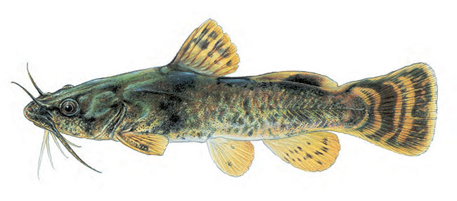
The following description is adapted from Holm and Mandrak (1998). The Northern Madtom (Noturus stigmosus Taylor, 1969) is a small (132 mm, maximum total length) catfish (Ictaluridae) recognized by an overall mottled colour pattern with three distinct saddle-shaped markings on the back, located at the front of the dorsal fin, behind the dorsal fin and at the adipose fin (Figure 1). Two pale spots that are smaller than the diameter of the eye are usually present anterior to the dorsal fin. The dorsal and adipose fins possess pale edges while three to four irregular crescent-shaped bars are present on the caudal fin, with the middle bar typically extending across the upper and lower caudal rays and touching the caudal peduncle. Reproductive males will develop a flattened head, diffusion of dark pigments and conspicuous swellings behind the eyes, on the nape and on the lips and cheeks. The Northern Madtom is most often confused with the Brindled Madtom (N. miurus), which lacks pale edges on the dorsal and adipose fins, has a black tip on the dorsal fin, and has a shallower notch between the adipose fin and the tail (Holm et al. 2009).
No subspecies of Northern Madtom have been recognized (Holm and Mandrak 1998); however, Mayden et al. (1992; cited in Holm and Mandrak 1998) suggested that it might be polytypic which may warrant its separation into several species. The Northern Madtom underwent a taxonomic revision and a new species (N. gladiator) was described from populations of the Coastal Plain in Kentucky and Tennessee (Thomas and Burr 2004). In a study examining the phylogenetic relationships among Noturus spp., Hardman (2004) compared nucleotide sequences from Northern Madtom populations above and below (now considered to be N. gladiator [Thomas and Burr 2004]) the Fall Line (a low east-facing cliff that parallels the Atlantic coastline from New Jersey to the Carolinas) and found them to be genetically less than 1% different, despite being morphologically differentiable. It is important to note that Canadian specimens were not included in these taxonomic studies.
Figure 1. The Northern Madtom (Noturus stigmosus). © 1996 Joseph R. Tomelleri.
1.3 Populations and distribution
Distribution:
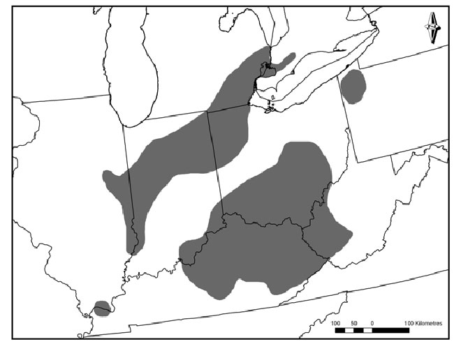
Global Range –The Northern Madtom is native to North America and has a disjunct distribution throughout parts of the Mississippi and western Lake Erie and Lake St. Clair drainages (Figure 2). It is found in several tributaries of the Mississippi drainage system in Tennessee. It is also present throughout most of the Ohio River basin in Indiana, Kentucky and Ohio, as well as in restricted areas of Illinois, Pennsylvania and West Virginia. In the western basin of Lake Erie, the Northern Madtom is found in several tributaries in Indiana, Michigan and Ohio, as well as in Lake St. Clair and the Detroit and St. Clair rivers, which form the border between Michigan and Ontario (Holm and Mandrak 2001).
Figure 2. Global range of the Northern Madtom.
Canadian range –In Canada, the Northern Madtom is known only from Lake St. Clair and the Detroit, St. Clair, Sydenham and Thames rivers (Figure 3). The species is believed to be extirpated from the Sydenham River (Holm and Mandrak 1998).
Percentage of global distribution in Canada –It is likely that less than 5% of the species global range occurs in Canada.
Distribution trend –The change in the distribution of the Northern Madtom is difficult to assess due to a lack of sampling data. It is unclear whether new records of the species (since it was first reported in Canada in 1963) are a result of a range expansion or more intensive sampling (Holm and Mandrak 1998).
Figure 3. Canadian range of the Northern Madtom. Note that the figure does not include a recently confirmed historical record from the East Sydenham River taken in 1929.
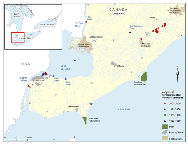
Enlarge figure 3. Canadian range of the Northern Madtom.
Population size and status:
Global population size and status –The Northern Madtom is considered to be rare to extremely rare throughout its range (Table 1) and has a global status rank of vulnerable (NatureServe 2009). The species is considered critically imperilled in Illinois, Indiana, Michigan, Ohio and West Virginia. In Pennsylvania and Kentucky the Northern Madtom is considered imperilled and imperilled/vulnerable, respectively. It has not been assigned a rank in Arkansas (NatureServe 2009). The global short-term trend of Northern Madtom populations is estimated as declining to stable (± 10% fluctuation to 30% decline) (NatureServe 2009).
Table 1. Canadian and U.S. national and provincial/state heritage status ranks for the Northern Madtom (NatureServe 2009)
| Canada and U.S. National Rank (NX) | Provincial/State Rank (SX) |
|---|---|
| Canada (N1N2) | ON (S1) |
| United States (N3) | AR (SNR), IL (S1), IN (S1), KY (S2S3), MI (S1), OH (S1), PA (S2), WV (S1) |
Canadian population size and status – In Canada, the Northern Madtom occurs within an area less than 1600 km2 and occupies an area less than 700 km2 (COSEWIC 2002); however, this does not include the recently confirmed St. Clair River record.
Lake St. Clair, Detroit River, St. Clair River:The first recorded occurrence of the Northern Madtom in Canada was a single specimen that was trawled from Lake St. Clair, near the outlet into the Detroit River, in 1963 (Trautman 1981). Although it was not recorded from Canada until 1963, it is likely that Northern Madtom has always been present but went undetected because it is a cryptic species. Additionally, the species is found in areas that are difficult to sample as a result of accessibility issues and the nature of the habitat (e.g., swift-flowing, deep, waters). In 1996, three juveniles were seined at night along the south shore of Lake St. Clair at the mouth of the Belle River (Holm and Mandrak 2001) and a single individual was found dead near the mouth of Pike Creek (Royal Ontario Museum [ROM], unpubl. data). The most recent Canadian record for Northern Madtom in Lake St. Clair is from 1999 when one specimen was captured incidentally by a commercial fisherman off of Walpole Island.
In 1994, a single Northern Madtom was caught near the original capture site on the Canadian side of the Detroit River (Holm and Mandrak 1998) and in 1996 approximately 50 specimens were either observed or collected around Peche Island in the Detroit River. In 2008, a total of 214 Northern Madtom were captured in the Detroit River during a mark-recapture study conducted by a graduate student with the U.S. Geological Survey (USGS); 145 specimens were captured on the American side of the river adjacent to Belle Isle and 69 specimens, including four young-of-the-year (YOY), were captured on several occasions (from one site) on the Canadian side near Peche Island (B. Daley, USGS, unpubl. data). One individual originally captured and marked at Belle Isle was recaptured almost a mile upstream near Peche Island (B. Daley, unpubl. data).
Preliminary results of sampling conducted at Fighting Island in 2009 indicate that Northern Madtom is present at this location, which is approximately 20 kilometres downstream of Peche Island. Seven specimens (102-126 mm TL) were captured in minnow traps at artificial spawning shoals created for Lake Sturgeon (Acipenser fulvescens) (U.S. Fish and Wildlife Service [USFWS], unpubl. data).
Holm and Mandrak (2001) suggested that the lack of Canadian records in the Detroit River and Lake St. Clair between 1963 and 1994 probably resulted from the limited amount of trawling and night sampling conducted, as well as errors in species identification.
Sampling (day and night trawls, and day and night seining) by the ROM in 1996 failed to capture or observe the Northern Madtom on the Canadian side of the St. Clair River; however, sampling conducted by Fisheries and Oceans Canada (DFO) in 2003 yielded a juvenile (suggesting successful reproduction) downstream of the Lambton Generating Station at the confluence of Clay Creek. Northern Madtom records exist for the American side of the St. Clair River; it was last recorded in 1995, when several larvae, YOY and adult specimens were captured (Carman 2001).
Thames River and Sydenham River:In July 1991, a specimen was captured by the ROM in the Thames River near Wardsville, and a juvenile Northern Madtom was captured at the same location in August 1997 (Holm and Mandrak 2001). From 2003 to 2008, juvenile and adult Northern Madtom were captured incidentally by graduate students conducting research on the Eastern Sand Darter (Ammocrypta pellucida). The majority of specimens were captured in the vicinity of Big Bend Conservation Area, located upstream of Wardsville. Targeted sampling for the Northern Madtom conducted in 2008 by DFO failed to capture any specimens; however, the species was captured incidentally in 2008 near Big Bend (A. Dextrase, OMNR, pers. comm. 2009).
A specimen originally identified as a Brindled Madtom caught in 1975 in the Sydenham River near Florence, was re-examined by the ROM in 1999 and identified as a Northern Madtom. More recently, an additional record of the Northern Madtom taken near Alvinston in 1929 was confirmed by the ROM (A. Dextrase, OMNR, pers. comm. 2011). These two records are representative of an established population in the Sydenham River; this is further supported by the proximity of other confirmed records within the Lake St. Clair watershed (i.e., Thames River and Lake St. Clair). No specimens have been recorded from the Sydenham River since 1975, despite repeated sampling in the vicinity of Florence (Holm and Mandrak 1998) as well as Alvinston; thus, it appears that the species may now be extirpated.
Percent of global abundance in Canada –The percentage of the species' global abundance in Canada is unknown; however, it is likely to be less than 5%.
Population trend –The presence of juveniles in Lake St. Clair, the Detroit River, the St. Clair River and the Thames River, indicates that reproduction is presently occurring; however, the lack of short- and long-term population abundance and demographic data in Canada greatly limits our ability to properly assess population trends and stability.
1.4 Needs of the Northern Madtom
1.4.1 Habitat and biological needs
Spawn to Hatch: Northern Madtom are cavity nesters, building nests in depressions under large rocks and in debris such as bottles, cans and boxes (Etnier and Starnes 1993, Goodchild 1993, Holm and Mandrak 1998, MacInnis 1998). Taylor (1969) observed that, in Michigan, the Northern Madtom reproduced earlier than the Brindled Madtom, and that clutch sizes were larger, ranging from 61 to 141 eggs. In Michigan, spawning occurs in mid- to late-July, similar to a population in the Canadian portion of Lake St. Clair (MacInnis 1998). Northern Madtom were observed and video recorded by MacInnis (1998) at one site (near Sandpoint Beach, close to the outflow into the Detroit River) in Lake St. Clair between 17 July and 13 August 1996, while conducting a study on Round Goby (Neogobius melanostomus) reproduction using artificial nest cavities. During this time, gravid Northern Madtom and recently spawned eggs were observed in the artificial cavities, and male Northern Madtom were observed guarding both eggs and newly hatched larvae. MacInnis (1998) concluded that reproduction in the Northern Madtom likely occurred over a one-month period and that males provided sole parental care of eggs, larvae and juveniles. Nests consisted of a small depression dug into the substrate under the artificial cavity and eggs were laid as a single mass. Fecundity was conservatively estimated as 32, 85 and 140 eggs for three separate egg masses (MacInnis 1998), a relatively low number; as a group, madtoms are one of the least fecund oviparous fishes in North America (Burr and Stoeckel 1999). MacInnis (1998) also proposed that the larger egg masses represented the spawning efforts of more than one female; however, this was not directly observed. Incubation time was estimated at five to ten days and YOY were measured at approximately 30 mm TL before their first winter (MacInnis 1998). The spawning sites in Lake St. Clair had substrates of sand and/or cobble and were surrounded by dense aquatic vegetation. Water depths ranged from 1.5 to 1.8 m, water temperature was approximately 23°C and there was a noticeable current flowing west into the Detroit River (MacInnis 1998). There is no information regarding the spawning habitat characteristics for the Northern Madtom in the Thames River.
Young-of-the-Year (YOY): There is almost no published information on the habitat requirements of YOY Northern Madtom. In Lake St. Clair, larvae were observed in nests being guarded by the male in August and were observed taking cover in surrounding vegetation when the nests were removed (MacInnis 1998); therefore, it is likely that they require some sort of structure to provide cover. In the Thames River, YOY have been captured from shallow (< 2 m) sandbars that had little flow (M. Finch, University of Waterloo, unpubl. data) as well as areas containing substrates of fine gravel (mean size 2-8 mm) and moderate flow (0.3 m/s) (A. Dextrase, Ontario Ministry of Natural Resources [OMNR], unpubl. data). The YOY of two related species, the Brindled Madtom and Tadpole Madtom (N. gyrinus), are typically found in shallow waters (0-2 m) over substrates of sand, mud and silt, with aquatic vegetation (Goodyear et 1982, Lane et al.1996b).
Juvenile (age 1 until sexual maturity [2 yrs]):The habitat requirements of juvenile Northern Madtom are unknown; however, a juvenile specimen was collected from the same site as an adult specimen in the Thames River (Holm and Mandrak 1998), suggesting that adult and juvenile habitat requirements are the same or similar.
Adult: Goodchild (1993) noted that small and sporadic populations suggest that the Northern Madtom has very specific ecological requirements and thus is probably intolerant of habitat degradation. However, more recent evidence suggests that the species tolerates a wide range of habitat conditions (Dextrase et al. 2003). It can be found in small creeks to large rivers, with clear to turbid water and moderate to swift current over substrates consisting of sand, gravel and rocks, occasionally with silt, detritus and accumulated debris. Although the species is somewhat tolerant of turbidity, it is believed to avoid extremely silty situations (Goodchild 1993). It is also occasionally associated with macrophytes, such as stonewort (Chara spp.) (Holm and Mandrak 2001). The Northern Madtom has been sampled at depths ranging from less than 1 m to 7 m, where it was either seined or trawled during the day and/or night. For example, two specimens were collected in the Thames River, which is very turbid (Secchi depth < 0.2 m), over a substrate consisting of sand, gravel and rubble, and devoid of silt or clay (Holm and Mandrak 2001). Other abiotic characteristics of the site also included a moderate current, maximum depth of 1.2 m, water temperature of 23-26°C, conductivity of 666 μS and a pH of 7.9 (Holm and Mandrak 2001). Sexual maturity in the Northern Madtom is believed to be reached at approximately two years of age (Taylor 1969).
The Northern Madtom is likely an opportunistic feeder with a diet consisting mainly of chironomids, mayflies, caddisflies, small fishes and crustaceans (Holm and Mandrak 2001). A gut analysis study by French and Jude (2001) found the gut contents of juvenile Northern Madtom to consist mostly of Diptera and Ephemeroptera. The Northern Madtom is very secretive and likely to be a nocturnal feeder (Goodchild 1993) and spawner (Coad 1995).
1.4.2 Ecological role
The Northern Madtom is a nocturnal, benthic feeder, and gut contents demonstrate its reliance on small benthic invertebrates, such as chironomids, mayflies and caddisflies, as well as small fishes and crustaceans. Other benthic fishes, such as other madtoms (Noturus spp.), gobies (Round Goby, Tubenose Goby [Proterorhinus marmoratus]) and sculpins (Cottus spp.), may directly compete with the Northern Madtom for these food sources.
1.4.3 Limiting factors
The Northern Madtom may be limited by several life-history traits which include: minimal temperature for spawning; spawning habitat requirements; and, fecundity and maximum age.
Populations of Northern Madtom in Canada appear to be at the northern edge of the species' distribution, which is limited by an estimated minimal spawning temperature of 23°C (Taylor 1969, MacInnis 1998). The Northern Madtom is a cavity spawner, thus the availability of suitable spawning habitat (silt-free cavities in substrate or under debris/rocks/logs) may also pose a limitation to the species. Competition for suitable spawning sites is likely to occur with the Brindled Madtom and potentially with the Round Goby; however, direct competition has yet to be documented (MacInnis 1998, Holm and Mandrak 2001). Although strong parental care (via nest-guarding) is provided by the male Northern Madtom, there is limited knowledge of the species' ability to compete for nest sites. Additional research is needed to clarify the role of interspecific competition on reproductive success. The Northern Madtom is a relatively short- lived species, with a maximum reported age of approximately two to three years (Taylor 1969) and likely spawns only once or twice in its lifetime (inferred from Burr and Stoeckel 1999). However, it should be noted that populations of many fishes at the northern limit of their range typically have longer life spans – this may also be the case for the Northern Madtom in Canada. As suggested by Simonson and Neves (1992), relying on only one or two cohorts for reproduction each year could jeopardize the long-term stability of some small madtom populations. This, combined with the low fecundity of the Northern Madtom, may limit the population potential of the species.
1.5 Threats
The threats identified for the Northern Madtom are considered to be potential threats as they have not been demonstrated empirically. Thus, the following discussion is based primarily on assumption and/or plausible cause.
1.5.1 Threat classification
Threats believed to be affecting the Northern Madtom are listed by waterbody in Table 2. Seven potential threats were ranked by the recovery team based on their expected relative impacts, spatial extent and expected severity. The threat classification parameters are defined as follows:
Extent– spatial extent of the threat in the waterbody (widespread/localized); Frequency– the frequency with which the threat occurs in the waterbody (seasonal/continuous);
Causal certainty– the level of certainty that it is a threat to the species (High – H, Medium – M, Low - L); and,
Severity– the severity of the threat in the waterbody (H/M/L).
Overall level of concern– composite level of concern regarding the threat to the species, taking into account the four parameters listed above (H/M/L).
Table 2. Threat classification table for Northern Madtom
Thames River
| Specific threat | Extent (widespread/ localized) | Frequency (seasonal/ continuous) | Causal certainty (high, medium, low) | Severity (high, medium, low) | Overall level of concern (high, medium, low) |
|---|---|---|---|---|---|
| Siltation | Widespread | Continuous | Medium | High | High |
| Turbidity | Widespread | Continuous | Low | High | High |
| Nutrient loadings | Widespread | Continuous | Medium | High/Medium | High |
| Exotic species | Localized | Unknown | Medium | Low (increasing) | High |
| Toxic compounds (pesticides/herbicides) | Localized | Seasonal | Medium | Medium | Medium |
| Physical habitat loss | Localized | Continuous | Medium | Extremely Low | Extremely Low |
Detroit River/Lake St. Clair
| Specific threat | Extent (widespread/ localized) | Frequency (seasonal/ continuous) | Causal certainty (high, medium, low) | Severity (high, medium, low) | Overall level of concern (high, medium, low) |
|---|---|---|---|---|---|
| Siltation | Localized | Continuous | Medium | Low/Medium | Medium |
| Turbidity | Widespread | Continuous | Low | Low | Low |
| Nutrient loadings | Widespread | Continuous | Medium | Medium/High | Medium? |
| Exotic species | Widespread | Continuous | Medium | High | High |
| Toxic compounds | Detroit River - Widespread; Lake St. Clair – Localized | Continuous | Medium | High | High |
| Physical habitat loss | Localized | Continuous | Medium | High | High |
St. Clair River
| Specific threat | Extent (widespread/ localized) | Frequency (seasonal/ continuous) | Causal certainty (high, medium, low) | Severity (high, medium, low) | Overall level of concern (high, medium, low) |
|---|---|---|---|---|---|
| Siltation | Localized | Continuous | Medium | Low/Medium | Medium |
| Turbidity | Widespread | Continuous | Low | Low | Low |
| Nutrient loadings | Widespread | Continuous | Medium | Medium/High | Medium? |
| Exotic species | Widespread | Continuous | Medium | High | High |
| Toxic compounds | Widespread | Continuous | Medium | High | High |
| Physical habitat loss | Localized | Continuous | Medium | High | High |
All populations
| Specific threat | Extent (widespread/ localized) | Frequency (seasonal/ continuous) | Causal certainty (high, medium, low) | Severity (high, medium, low) | Overall level of concern (high, medium, low) |
|---|---|---|---|---|---|
| Climate change | Widespread | Continuous | High | Low | Low |
1.5.2 Description of threats
Habitat loss and degradation:
Siltation and turbidity– An increase in suspended sediments leads to increased turbidity, decreased light penetration and lower primary productivity. High rates of sediment deposition can alter the composition of gravel and cobble habitats, thus impacting the quality and availability of fish habitat (Bailey and Yates 2003). The impacts of high sediment loading on the Northern Madtom are not fully understood. The species has been collected from highly turbid waters, such as the Thames River, suggesting that the species has some level of tolerance to turbidity. However, the Northern Madtom is no longer found in the turbid Sydenham River, which is located in an intensive agricultural landscape (Holm and Mandrak 1998). It is unclear whether the Northern Madtom is primarily impacted by suspended sediments in the water column or excessive sediment deposition on the substrate; however, it seems likely that high rates of silt deposition could affect the species ability to nest in cavities (Dextrase et al. 2003, The Thames River Recovery Team [TRRT] 2005). Silt deposition may also indirectly impact the Northern Madtom through a potential reduction in their invertebrate food supply.
Direct soil deposits through agricultural tile drainage systems and overland runoff have the greatest influence on siltation rates (Bailey and Yates 2003). Furthermore, channelization and loss of riparian zones along lakes and watercourses increases the level of sediment input, as well as the rate of streambank and shoreline erosion. Livestock grazing and ploughing to the edge of a watercourse destroys riparian vegetation, thus impacting rates of silt deposition into adjacent watercourse (Bailey and Yates 2003). In the United States, channelization is the most serious threat facing the Northern Madtom, followed closely by increased siltation and turbidity (NatureServe 2009).
Nutrient loading– Increased nutrient loading can have an impact on water quality and may have direct and indirect effects on the Northern Madtom. Nutrient loading, especially of phosphorus and nitrogen, from agricultural fertilization and manure use practices, as well as effluents from sewage treatment plants and faulty septic systems, can adversely affect habitat quality. Such negative impacts may include increased turbidity, increased occurrence of harmful algal blooms, disruption of food webs and increased macrophyte growth (Bailey and Yates 2003). In the Thames River, phosphorous levels at most sites in the watershed have shown a gradual downward trend since the 1970s; however, levels remain above provincial guidelines of 30 µg/L for the protection of aquatic life (The Thames River Ecosystem Recovery Team [TRERT] 2004). From the period covering 2001-2006, the median total phosphorous concentration in the Thames River was 113 µg/L, second only to the Don River in Ontario for total phosphorous levels (Ontario Ministry of the Environment 2009). Additionally, mean nitrite/nitrate values in the Thames River watershed were over the recommended limits from 1991-2000, and nitrate levels have shown an increasing trend in the watershed over the past 30 years (TRERT 2004).
Physical habitat loss– Physical habitat loss is one of the leading threats to aquatic species at risk (Dextrase and Mandrak 2006), and this is likely the case for the Northern Madtom. Habitat loss from dredging, as well as lake and river shoreline modifications (e.g., shoreline hardening projects, piers, docks, marinas) along the Detroit River and Lake St. Clair, is a significant and ongoing concern.
Toxic compounds– The effects of toxic compounds on the Northern Madtom are currently unknown. The species is found in the Detroit and St. Clair Rivers which have both been designated as an Area of Concern (AOC). An AOC is a severely degraded geographic area within the Great Lakes Basin with known impairments of beneficial water use that can impact the area’s ability to support aquatic life (Great Lakes Information Network 2009). Beneficial use impairments have been identified in the St. Clair River (10 impairments) and the Detroit River (11) as a result of urban and industrial development, bacteria, PCBs, PAHs, metals, oils and greases (U.S. Environmental Protection Agency 2009). In the Thames River, pollutants may include pesticides from agricultural and urban areas, chloride (e.g., from road salt, wastewater treatment and water softeners) and metals (TRERT 2004). Over the past 30 years, chloride levels in the Thames River have increased continually at sites across the watershed, but in most cases remain below the Environment Canada guidelines for sensitive aquatic species (TRERT 2004). In the United States, chemical run-off from agricultural and urban sources is one of the major threats facing Northern Madtom (NatureServe 2009). A related species, the Neosho Madtom (N. placidus), appears to be limited by the presence of heavy metals such as cadmium, lead and zinc (Wildhaber et al. 2000).
Further investigation is required to identify the impacts of pollutants and to fully understand the type and extent of stress exerted upon Northern Madtom populations in Canada.
Exotic species– The negative impacts of exotic species on native fishes in the Great Lakes basin have been well documented (e.g., French and Jude 2001, Thomas and Haas 2004). Exotic species may affect the Northern Madtom through direct competition for space and habitat, food, spawning sites and through the restructuring of aquatic food webs. The occurrence of the Round Goby has been implicated in the decline of the Mottled Sculpin (Cottus bairdii) and the Logperch (Percina caprodes) in the St. Clair River (French and Jude 2001). Given the ecology of the Round Goby, it could, potentially, directly compete with the Northern Madtom for food and habitat (MacInnis 1998, Jansen and Jude 2001). The Round Goby could also directly compete with Northern Madtom for spawning sites; however, the Northern Madtom would likely not be as vulnerable to competition for spawning sites as the spawning seasons of the two species barely overlap (MacInnis and Corkum 2000).
Although the Round Goby has been found in the lower reaches of the Sydenham and Thames rivers, recent sampling on both rivers has documented considerable upstream movement in 2007 to areas where it had not previously been found (Poos et al.2010). In the Sydenham River, the Round Goby has been confirmed in the mid-reaches, just 3 km downstream from the town of Florence. The impacts of the exotic Zebra Mussel (Dreissena polymorpha) and Quagga Mussel (D. bugensis) on the Northern Madtom are unknown but may negatively impact the species by colonizing potential nesting cavities as well as altering food web dynamics and surrounding water quality.
Further research on the impacts of exotic species including Zebra and Quagga mussels, on the Northern Madtom in the Detroit River – St. Clair River corridor, as well as in the Sydenham and Thames rivers is required to provide recovery planners with better tools to manage and understand the Northern Madtom within these systems.
Climate change– Climate change is expected to impact the Northern Madtom and other fishes at risk in southwestern Ontario (Essex-Erie Recovery Team [EERT] 2008). Several impacts related to climate change are expected to impact aquatic communities of the Great Lakes basin, including: increases in water and air temperatures; changes in water levels; shortening of the duration of ice cover; increases in the frequency of extreme weather events; emergence of diseases; and, shifts in predator-prey dynamics (Lemmen and Warren 2004). The effects of climate change will be widespread and should be considered a contributing impact to species at risk and all habitats. While it is possible that some species, including the Northern Madtom, may benefit initially from the effects of climate change through possible northern range expansions, a suite of reactions related to expected changes in evaporation patterns, vegetation communities, decreased lake levels, increased intensity and frequency of storms, and decreases in summer stream water levels may offset the direct benefits of increased water temperatures (EERT 2008).
1.6 Actions already completed or underway
Ecosystem recovery strategies: The following aquatic ecosystem-based recovery strategies include the Northern Madtom and are currently being implemented by their respective recovery teams. Each recovery team is co-chaired by DFO and a Conservation Authority and receives support from a diverse partnership of agencies and individuals. Recovery activities implemented by these teams include active stewardship and outreach/awareness programs to reduce identified threats; for further details on specific actions currently underway, please refer to the approaches identified in Table 6. Funding for these actions is supported by Ontario’s Species at Risk Stewardship Fund and the government of Canada’s Habitat Stewardship Program for Species at Risk. Additionally, research requirements for species at risk identified in recovery strategies are funded, in part, by the federal Interdepartmental Recovery Fund.
Essex-Erie Region Fishes -The Essex-Erie region is located on the north shore of Lake Erie and is bordered to the east by the Grand River watershed, to the west by the Detroit River and to the north by the Lake St. Clair and Thames River watershed. The long-term goal of this strategy is "to maintain and restore ecosystem quality and function in the Essex-Erie region to support viable populations of fish species at risk, across their current and former range" (EERT 2008).
Sydenham River Ecosystem -The long-term goal of this strategy is "to sustain and enhance the native aquatic communities of the Sydenham River through an ecosystem approach that focuses on species at risk" (Dextrase et al.2003).
Thames River Ecosystem -The goal of this strategy is to develop "a recovery plan that improves the status of all aquatic species at risk in the Thames River through an ecosystem approach that sustains and enhances all native aquatic communities" (TRRT 2005).
Walpole Island Ecosystem Recovery Strategy: The Walpole Island ecosystem recovery team was established in 2001 to develop an ecosystem-based recovery strategy for the area containing the St. Clair delta, the largest freshwater delta in the world, with the goal of outlining steps to be taken to maintain or rehabilitate the ecosystem and species at risk (Bowles 2005). This recovery strategy includes several fishes at risk, including the Northern Madtom. The recovery goal of the Walpole Island ecosystem recovery strategy is "to conserve and recover the ecosystems of the Walpole Island Territory in a way that is compliant with the Walpole Island First Nation Environmental Philosophy Statement, provides opportunities for cultural and economic development and provides protection and recovery for Canada’s species at risk" (Bowles 2005).
Remedial action plans (RAPs): RAPs have been developed for the Detroit River AOC and the St. Clair River AOC to guide restoration and protection efforts. RAPs proceed through three stages: 1) Determination of severity and causes of environmental degradation; 2) Identification of goals, recommendation of actions that will lead to protection and restoration of ecosystem health; and, 3) Implementation of recommended actions and progress towards restoration and protection efforts measured (Environment Canada 2008a). There are 45 and 104 recommended remedial actions for the St. Clair River AOC and Detroit River AOC, respectively, and many of these have already been implemented (Environment Canada 2008b,c).
Recent surveys: Table 3 summarizes recent fish surveys conducted by various agencies within areas of known occurrence of the Northern Madtom.
Table 3. Summary of recent fish surveys in areas of Northern Madtom occurrence (adapted from EERT 2008)
| Waterbody/ general area | Survey description (years of survey) | Northern Madtom captured (Yes/No) |
|---|---|---|
| Lake St. Clair | OMNR nearshore fish community survey (2005 and 2007-2010; south shore)a | No |
| Lake St. Clair | OMNR nearshore fish community survey (2007; south shore)d | No |
| Lake St. Clair | Michigan Department of Natural Resources (DNR) fish community survey (1996-2001; south shore)b | No |
| Lake St. Clair | DFO sampling (2003, 2004; St. Clair NWA)d | No |
| Lake St. Clair | ROM (2001-2002; Walpole Island) | No |
| Lake St. Clair | DFO/University of Guelph sampling (2003-2004; Mitchell’s Bay)d,e | No |
| Detroit River | DFO/University of Windsor fish-habitat association study (2003-2004)a,d | No |
| Detroit River | DFO/University of Guelph coastal wetlands study (2004-2005) | No |
| Detroit River | DFO Area of Concern sampling (2003-2004) | No |
| Detroit River | Michigan DNR/USFWS/OMNR nearshore fish community sampling (2008)a,d,e | No |
| Detroit River | USGS Northern Madtom sampling (2008)e | Yes |
| Detroit River | USFWS sampling (2009)e | Yes |
| St. Clair River | DFO fish community sampling (2003, 2004) | Yes |
| St. Clair River | DFO/University of Guelph fish community sampling (2007)d | No |
| Thames River | UTRCA fish SAR survey and gear comparison study 2003 and 2004, upper Thames Rivera,b,c,d,e | No |
| Thames River | DFO/UTRCA fish SAR survey and gear comparison study 2003 and 2004, lower Thames River and lower Thames tributariesa,b,c,d,e | Yes |
| Thames River | DFO/University of Waterloo lower Thames River Eastern Sand Darter sampling (2006, 2007)a | Yes |
| Thames River | DFO/OMNR/Trent University lower Thames River Eastern Sand Darter sampling (2006-2008)a | Yes |
| Thames River | DFO targeted Northern Madtom gear comparison survey (2008)c,a,e | No |
| Sydenham River | ROM non-targeted species at risk sampling (1997)a | No |
| Sydenham River | DFO/University of Guelph (2002-2003)a,c (including night seining at Florence [historic site]) | No |
Gear Type:
a seine
b trawl
c backpack electrofishing
d boat electrofishing
e additional gear (fyke nets, trap nets, minnow traps etc).
1.7 Knowledge gaps
In Canada, the Northern Madtom has not been thoroughly studied, and, given its rarity and secretive, nocturnal habits, there are numerous aspects regarding its biology, population structure, ecology and life-history traits that remain unknown. This information is required to refine recovery approaches. Threat clarification is required, particularly concerning siltation and the impacts of the Round Goby and Zebra Mussel.
2. Recovery
The following goals, objectives and recovery approaches were adapted from the Essex-Erie Recovery Strategy (EERT 2008) which covers a portion of the Canadian range of the Northern Madtom. Additional considerations were included from the Sydenham River Recovery Strategy (Dextrase et al. 2003) and Thames River Recovery Strategy (TRRT 2005).
2.1 Recovery feasibility
The recovery of the Northern Madtom is believed to be biologically and technically feasible. The following feasibility criteria
-
Are individuals capable of reproduction currently available to improve the population growth or population abundance?
Yes. Reproducing populations are believed to exist within the Canadian range of the Northern Madtom (i.e., lower Lake St. Clair, the Detroit River, the Thames River and potentially the St. Clair River).
-
Is sufficient habitat available to support the species or could it be made available through habitat management or restoration?
Yes. Sufficient habitat is present at locations with extant populations. At locations with extirpated populations, suitable habitat may be made available through recovery actions.
-
Can specific threats to the species or its habitats be avoided or mitigated through recovery actions?
Yes. The impacts/effects of suspected threats, such as sediment and nutrient loading, can be mitigated through established restoration methods.
-
Do the necessary recovery techniques exist and are they demonstrated to be effective?
Yes. Recovery techniques to reduce sediment and nutrient loading (e.g., stewardship, Best Management Practices [BMPs]) are well established and proven to be effective.
Captive rearing and translocations have been used in the western and southeastern United States towards recovery of endangered fishes, including non-game benthic species (e.g., Andreasen and Springer 2000, Shute et al. 2005). Although there are no published studies on the husbandry of Northern Madtom, captive rearing and translocations of the closely related Smoky Madtom (N. baileyi) and Yellowfin Madtom (N. flavipinnis) have been successfully accomplished in Abrams Creek, Tennessee (Shute et al. 2005).
The Northern Madtom is a naturally rare component of the fish community throughout its range in Canada. The level of effort required for recovery of this species would likely be moderate for the Detroit River, Lake St. Clair, St. Clair River and Thames River given that these populations are currently believed to be reproducing. The level of effort required for recovery is unknown for the Sydenham River population given the uncertainty surrounding the population status.
2.2 Recovery goal
The long-term recovery goal (greater than 20 years) is to sustain and enhance the viability of existing populations of Northern Madtom in the Erie-Huron corridor, the Thames River (the reach of river from Littlejohn Rd. upstream to an area near Tate Corners) and the Sydenham River, if the species is still present in the system.
2.3 Population and distribution objective(s)
Population and distribution objectives for the Northern Madtom over the next five years are to maintain distributions of extant populations in Lake St. Clair, the Detroit River, the St. Clair River and the Thames River. Quantifiable objectives relating to individual populations are not currently possible; these will be developed once necessary surveys and studies have been completed. Knowledge gaps will be addressed by recovery actions given 'urgent' priority included in the recovery planning approaches.
2.4 Recovery objectives
In support of the long-term goal, the following short-term recovery objectives will be addressed over the next five to ten years:
- Refine population and distribution objectives;
- Ensure the protection of critical habitat;
- Determine long-term population and habitat trends;
- Evaluate and mitigate threats to the species and its habitat;
- Determine the feasibility of relocations and captive rearing;
- Ensure efficient use of resources (human and fiscal) during recovery planning efforts; and,
- Improve awareness of the Northern Madtom and engage the public in the conservation of the species.
2.5 Approaches recommended to meet recovery objectives
2.5.1 Recovery planning
The overall approaches recommended to meet the recovery objectives have been organized into three categories: 1. Research and Monitoring; 2. Management and Coordination; and, 3. Stewardship, Outreach and Awareness. Each category is summarized in a table detailing specific steps with a priority ranking (urgent, necessary, beneficial), a link to the recovery objectives, the broad approach, a description of the threat addressed, and suggested outcomes or deliverables to measure progress. A more detailed narrative is included after each table when further explanation of specific approaches is required. Implementation of the following approaches will be accomplished in coordination with relevant ecosystem-based recovery teams and other relevant organizations. Within the recovery planning approaches, higher priority will be given to urgent priorities for Research and Monitoring (Table 4), as these data will be used to inform the approaches in Tables 5 and 6. Refer to Tables 7 and 11 for suggested timelines on when urgent priorities may be completed. Note that these timelines are dependent on available resources over the next five years.
Table 4. Recovery planning table – research and monitoring (adapted from the Essex-Erie Recovery Strategy [EERT 2008])
| Priority | Objective addressed | Broad approach to address threats | Threats addressed | Specific steps | Outcomes or deliverables (identify measurable targets) |
|---|---|---|---|---|---|
| Urgent | i | 1. Background surveys – extant/historical occurrences | All | Conduct targeted sampling in areas of occupied habitat as well as historically occupied habitat (e.g., Sydenham River). Use sampling techniques proven to detect Northern Madtom (e.g., night/day seining and trawling) | Will determine presence/absence, health, range, abundance, and population demographics and contribute to the identification of critical habitat. |
| Urgent | i | 2. Background surveys – new occurrences | All | Conduct targeted sampling in areas lacking Northern Madtom records but possessing potentially suitable habitat. Sampling should be done during both the day and night using sampling techniques proven to detect Northern Madtom. | May detect new occurrences of Northern Madtom. |
| Urgent | i, iii | 3. Monitoring – populations and habitat | All | Establish sampling protocol for Northern Madtom, which will be informed by the results of background surveys. Establish and implement a standardized index population and habitat monitoring program using the sampling protocol for Northern Madtom. | Will enable an assessment of changes in range, abundance, key demographic characters and changes in habitat features, extent and health. |
| Urgent | ii | 4. Research - habitat requirements (currently occupied habitat) | All | Determine the seasonal habitat needs, including home range and species movement, of all life-stages of the Northern Madtom. | Will allow for the full identification of critical habitat for Northern Madtom. Will assist with the development of a habitat model. |
| Urgent | iv | 5. Threat evaluation- exotic species | Exotic species | Investigate the impacts of Round Goby and Zebra Mussel on Northern Madtom. Studies to include impacts on Northern Madtom spawning success. | Will identify the degree to which Round Goby and Zebra Mussel may impact Northern Madtom. |
| Urgent | iv | 6. Threat evaluation – habitat loss; siltation | Physical habitat loss; siltation | Investigate the impacts of physical habitat changes on the Northern Madtom. | Will identify the degree to which the Northern Madtom is affected by physical habitat alterations (e.g., dredging, sedimentation and shoreline hardening). |
| Necessary | iv | 7. Monitoring – Zebra Mussel | Exotic species | Monitor the spread of Zebra Mussel in watersheds occupied by the Northern Madtom. | Will enable an assessment of the risk posed to Northern Madtom should Zebra Mussel spread and/or increase in number in occupied areas. |
| Necessary | v | 8. Genetic comparisons | All | Examine genetic relationships between populations as well as the amount of genetic variation within populations. Compare genetics of Canadian populations of Northern Madtom to populations in the U.S. | Will help to distinguish populations. Will contribute necessary information should population enhancement through relocations or captive rearing be required. |
| Necessary | iv | 9. Threat evaluation- contaminants | Contaminants | Investigate the impacts (lethal/sub-lethal) of pollutants in the Huron-Erie corridor, and nutrient loading in the Sydenham and Thames rivers, on Northern Madtom. | Will enable an assessment of risks and the identification of contaminants of concern for Northern Madtom. |
| Necessary | v | 10. Research – captive rearing and relocations | All | If the need for population supplementation is determined, develop relocation and captive rearing techniques and incorporate into population- specific action plans as required. Conduct population genetics research prior to captive rearing and relocation (See Approach #8). | Will help to determine the feasibility of relocations and/or captive rearing. |
1 – 2. Background surveys: The Northern Madtom is known from only five general locations in watersheds throughout its Canadian range and fewer than 100 specimens have ever been captured in Canada. The Northern Madtom may be somewhat more widely distributed than currently known, as a result of its secretive behaviour, the relative lack of appropriate sampling (e.g., night seining, trawling and possibly minnow traps [Northern Madtom were caught in minnow traps by the USGS (2006) while monitoring a Lake Sturgeon spawning habitat rehabilitation project]) within its Canadian range, as well as possible errors in field identification (Holm and Mandrak 1998). Surveys are required in areas of current and historical occurrence to: confirm the spatial distribution of extant populations; confirm the loss of historical populations; identify potentially suitable habitat; and, to detect the presence of Round Goby and Zebra Mussel. It is recommended that the Sydenham and Thames rivers be sampled during periods of low flow (i.e., during the summer or early fall).
3. Monitoring – populations and habitat:A monitoring program is required to provide an index of abundance and trend over time data, as well as to analyze habitat use and availability and changes in these parameters over time. Sampling methods will be informed through successful protocols developed during background surveys.
10. Research – captive rearing and relocations: If the need for population supplementations is determined, source populations need to be identified. Ideally, source populations possess a high level of genetic diversity and genetic composition developed under similar historic conditions as the repatriation site. Any relocations that are considered will follow the Repatriation Approach outlined in the Essex-Erie Recovery Strategy (EERT 2008), should they be deemed necessary.
Table 5. Recovery planning table – management and coordination
| Priority | Objective number | Broad approach | Threat addressed | Specific steps | Outcomes or deliverables (identify measurable targets) |
|---|---|---|---|---|---|
| Urgent | vi | 1. Coordination with other recovery teams and relevant organizations | All | Work with relevant organizations (e.g., USFWS, Conservation Authorities, First Nations) and ecosystem- and single species recovery teams to share knowledge, implement recovery actions and to obtain incidental sightings. | Will combine resources, ensure information dissemination, help to prioritize most urgent actions across the species' range and allow for a coordinated approach to recovery. |
| Urgent | vi, vii | 2. Municipal planning – involvement | Physical habitat loss | Encourage municipalities to protect habitats that are important to the Northern Madtom in their Official Plans. | Will assist with the recovery of the Northern Madtom and prevent further impairment of water quality of watersheds it inhabits. |
| Urgent | ii | 3. Habitat management | Physical habitat loss | Ensure planning and management agencies are aware of habitats that are important to Northern Madtom. | Will result in the protection of important Northern Madtom habitat from industrial and development activities (e.g., dredging, marinas). |
| Necessary | vi, vii | 4. Evaluation of watershed-scale stressors | All | In cooperation with relevant ecosystem-based recovery teams and organizations, evaluate watershed-scale stressors to populations and their habitats. | Will identify multiple stressors that may affect Northern Madtom populations. |
| Beneficial | iv | 5. Exotic species management plan | Exotic species | Develop a management plan addressing potential risks and proposed actions in response to existing exotic species and to the arrival or establishment of new exotic species. | Will ensure a quick response should this threat more fully materialize. |
- Coordination with other recovery teams and relevant organizations:Many of the threats facing the Northern Madtom are a result of habitat degradation that affects numerous aquatic species. Ecosystem-based recovery strategies, such as those for the Essex-Erie region and the Sydenham and Thames rivers, have incorporated the biological and ecological requirements of the Northern Madtom into relevant watershed-based recovery approaches as well as species specific approaches. A coordinated, cohesive approach between these teams and other relevant agencies (e.g., USGS/USFWS and First Nations) that maximizes opportunities to share resources, information and combine efficiencies is recommended.
Table 6. Recovery planning table – stewardship, outreach and awareness
Stewardship and habitat improvement actions should be directed geographically to address the most serious threats identified in waterbodies inhabited by the Northern Madtom (refer to Table 2 for threat information).
| Priority | Objective number | Broad approach | Threat addressed | Specific steps | Outcomes or deliverables (identify measurable targets) |
|---|---|---|---|---|---|
| Urgent | vi, vii | 1. Collaboration and information sharing* | All | Collaborate with relevant groups, including Aboriginal groups, and recovery teams to address recovery actions of benefit to the Northern Madtom. | Will combine efficiencies in addressing common recovery actions, and ensure information is disseminated in a timely cooperative fashion. |
| Urgent | vi, vii | 2. Stewardship and habitat initiatives* | All | Promote stewardship among landowners abutting aquatic habitats of Northern Madtom, as well as other local residents and First Nations. | Will raise community support and awareness of recovery initiatives. Will raise profile of Northern Madtom and improve awareness of opportunities to improve water quality and species habitat. |
| Urgent | iv, vi, vii | 3. Stewardship – implementation of BMPs* | Physical habitat loss; Siltation; Nutrient loading; Toxic compounds | Work with landowners and other interest groups to implement BMPs in areas where they will provide the most benefit. Encourage the completion and implementation of Environmental Farm Management Plans (EFPs) and Nutrient Management Plans (NMPs). | Will minimize threats from soil erosion, stream sedimentation, and nutrient and chemical contamination. |
| Necessary | vii | 4. Communications strategy | All | Develop and implement strategy for communicating with target land users/stakeholders with respect to recovery activities as required. | Will provide a strategic basis for improving public awareness of species at risk and promote ways in which community and public involvement can be most effectively solicited for the recovery of the species. |
| Necessary | vii | 5. Stewardship – financial assistance/ incentives* | Physical habitat loss; Siltation; Nutrient loading; Toxic compounds | Facilitate access to funding sources for land owner and local community groups and First Nations engaged in stewardship activities. | Will facilitate the implementation of recovery efforts, BMPs associated with water quality improvements, sediment load reduction, etc. |
| Necessary | vii | 6. Awareness – addressing landowner concerns | All | Provide clear communications addressing funding opportunities and landowner concerns and responsibilities under the federal Species at Risk Act (SARA) and the provincial Endangered Species Act, 2007 (ESA). | Will address landowner concerns surrounding the Northern Madtom and facilitate public interest and involvement in stewardship initiatives. |
| Beneficial | iv, vii | 7. Exotic species/baitfish introductions | Exotic species | Increase public awareness of the impacts of exotic species on the natural ecosystem and encourage the use of existing exotic species reporting systems. Anglers should be discouraged from emptying the contents of their bait-buckets in waterbodies where the bait was not captured. | Will reduce the transport and release of exotics (including baitfish) and prevent their establishment in areas inhabited by the Northern Madtom that do not already have exotic species. |
* Approaches currently being implemented by one or more ecosystem-based recovery programs.
- Stewardship and habitat initiatives: Basin-wide efforts are required to improve habitat quality at locations currently and historically occupied by Northern Madtom. This represents an important opportunity to engage land owners, local communities, Aboriginal groups and stewardship councils on the issues of Northern Madtom recovery, ecosystem and environmental health, clean water protection, nutrient management, BMPs, stewardship projects and associated financial incentive programs. Towards this end, the recovery team will work closely with relevant organizations as well as the three ecosystem-based recovery teams, all of which have established on-going stewardship programs that will benefit the species.
- Stewardship – implementation of BMPs: Implementation will be informed through proposed research on evaluating threat factors for the Northern Madtom. The implementation of BMPs will be largely facilitated through established stewardship programs. Additional stewardship programs will be directed as necessary to areas outside the boundaries of ecosystem-based programs. To be effective, BMPs should be targeted to address the primary threats affecting critical habitat. BMPs implemented will include those relating to: the establishment of riparian zones; soil conservation; herd management; septic improvements to prevent nutrient run-off; nutrient and manure management; and, tile drainage. Establishing riparian zones reduces nutrient (nitrogen and phosphorous) and sediment inputs to receiving waters and overland run-off. Restriction of livestock from watercourses leads to reductions in erosion and sediment and nutrient loadings. Nutrient and manure management will reduce nitrogen and phosphorous inputs into adjacent waterbodies, thereby improving water quality. Low-till practices can reduce soil erosion and improve soil structure while reducing the sediment loads of adjacent watercourses. Environmental Farm Plans prioritize BMP implementation at the level of individual farms and are often a pre-requisite for funding programs.
2.6 Performance measures
The overall success of implementing the recommended recovery approaches will be evaluated primarily through routine population (distribution and abundance) and habitat (quality and quantity) surveys and monitoring. During the next five years, the recovery team will focus on completing recovery actions identified as "urgent" for the Northern Madtom. The recovery strategy will be reported on in five years to evaluate the progress made toward short-term and long-term targets, and the current goals and objectives will be reviewed within an adaptive management planning framework with input from ecosystem recovery teams. Performance measures to evaluate the recovery process in meeting recovery objectives over the next five years are outlined in Table 7.
Table 7. Performance measures for evaluating the achievement of recovery objectives
| Recovery objective | Performance measures |
|---|---|
| 1. Refine population and distribution objectives. | Completion of background surveys required to fully describe all extant populations by 2015. |
| 2. Ensure the protection of critical habitat. | Completion of activities outlined in the Schedule of Studies for the complete determination of critical habitat within the proposed timelines. |
| 3. Determine long-term population and habitat trends. | Population and habitat monitoring program established by 2014 (within regions currently identified as critical habitat). |
| 4. Evaluate and mitigate threats to the species and its habitat. | Report results of research on the impacts/effects of competition by the Round Goby by 2014. Report results of additional research that assists with the evaluation of impacts/effects of threats to the Northern Madtom by 2016. Quantification of BMPs (e.g., number of NMPs or EFPs established) implemented to address threats by 2014. |
| 5. Examine the feasibility of relocations and captive rearing. | Report on the feasibility (and need) for relocations and captive rearing of the Northern Madtom. |
| 6. Ensure efficient use of resources (human and fiscal) during recovery planning efforts. | Collaboration with all ecosystem recovery teams and other stakeholders. |
| 7. Improve awareness of the Northern Madtom and engage the public in the conservation of the species. | Document any changes in public perceptions and support for identified recovery actions through guidance identified in the communications strategy (by 2015). |
2.7 Critical habitat
2.7.1 General identification of the Northern Madtom’s critical habitat
The identification of critical habitat for Threatened and Endangered species (on Schedule 1) is a requirement of the SARA. Once identified, SARA includes provisions to prevent the destruction of critical habitat. Critical habitat is defined under section 2(1) of SARA as:
…the habitat necessary for the survival or recovery of a listed wildlife species and that is identified as the species' critical habitat in the recovery strategy or in an action plan for the species". [s. 2(1)]
SARA defines habitat for aquatic species at risk as:
… spawning grounds and nursery, rearing, food supply, migration and any other areas on which aquatic species depend directly or indirectly in order to carry out their life processes, or areas where aquatic species formerly occurred and have the potential to be reintroduced."[s. 2(1)]
For the Northern Madtom, critical habitat has been identified to the extent possible, using the best information currently available. The critical habitat identified in this recovery strategy describes the geospatial areas that contain the habitat necessary for the survival or recovery of the species. The current areas identified may be insufficient to achieve the population and distribution objectives for the species. As such, a schedule of studies has been included to further refine the description of critical habitat (in terms of its biophysical functions/features/attributes as well as its spatial extent) to support its protection.
2.7.2 Information and methods used to identify critical habitat
Using the best available information, critical habitat has been identified using a 'bounding box' approach for populations in the Detroit River and the lower Thames River where the Northern Madtom presently occurs; additional areas of potential critical habitat within Lake St. Clair will be considered in collaboration with Walpole Island First Nation.
This approach requires the use of essential functions, features and attributes for each life-stage of the Northern Madtom to identify patches of critical habitat within the 'bounding box' which is defined by occupancy data for the species. Life stage habitat information was summarized in chart form using available data and studies referred to in Section 1.4.1 (Habitat and biological needs). The bounding box approach was the most appropriate, given the limited information available for the species and the lack of detailed habitat mapping for these areas. Where habitat information was available (e.g., Aquatic Landscape Inventory System (ALIS)), it was used to identify critical habitat. Specific methods and data used (such as the use of ALIS) are summarized below.
Thames River: Recent sampling datasets used in the identification of critical habitat for the Northern Madtom for the Thames River are summarized in Table 3; although the species was not detected during targeted sampling by DFO in 2008, the species was captured incidentally during surveys conducted from 2003-2008. The most recent records for Northern Madtom in the Thames River resulted from sampling conducted by two graduate students studying the Eastern Sand Darter (See Table 3).
Within the Thames River, critical habitat was informed through the use of an ecological classification system (i.e., ALIS). The ALIS classification was developed by the OMNR to define stream segments based on a number of unique characteristics found only within those valley segments. Each valley segment is defined by a collection of landscape variables that are believed to have a controlling effect on the biotic and physical processes within the catchment. Therefore, if a population has been found in one part of the ecological classification, there is no reason to believe that it would not be found in other spatially contiguous areas of the same valley segment. Critical habitat for the Northern Madtom within the Thames River was therefore identified as the reach of river that includes all contiguous ALIS segments from the uppermost stream segment with the species present to the lowermost stream segment with the species present.
Detroit River: Recent sampling datasets (2003-2009) used in the identification of critical habitat for the Northern Madtom for the Detroit River are summarized in Table 3. To define the 'bounding box' for occupied locations at Peche Island and Fighting Island, a 'population range envelope' was used. The population range envelope is a projected rectangle around the occurrence points based on the minimum and maximum latitude and longitude values. In order to account for normal movements within a home range, the envelope was buffered by a distance of approximately 51.55 m. This buffer was determined using the radius of the home range of the Northern Madtom, which was calculated using a body size – waterbody size dependent method (Woolnough et al. 2009).
Population viability:
Comparisons of the area of critical habitat identified for each population were made with estimates of the spatial requirements for a minimum sustainable population size. The minimum area for population viability (MAPV) for all life-stages of the Northern Madtom were estimated for both riverine (river) and lacustrine (lake) populations in Canada. The MAPV is defined as the amount of exclusive and suitable habitat required for a demographically sustainable recovery target based on the concept of a minimum viable population size (MVP) (Vélez-Espino et al. 2010). Therefore, the MAPV is a quantitative metric of critical habitat that can assist with the recovery and management of species at risk (Vélez-Espino et al. 2010). Using a target MVP of 2.7 million adults under a 10% probability of catastrophe per generation, the MAVP for a population of Northern Madtom was estimated to be about 60 ha and 315 ha in rivers and lakes, respectively (Matchett et al. in press).
MAPV values are somewhat conservative in that they represent the sum of habitat needs calculated for each life-history stage of the Northern Madtom; these figures do not take into account the potential for overlap in the habitat of the various life-history stages and may overestimate the area required to support an MVP.
2.7.3 Identification of critical habitat: biophysical function, features and their attributes
There is limited information on the habitat needs for the various life stages of the Northern Madtom. Table 8 summarizes available knowledge on the essential functions, features and attributes for each life-stage (refer to section 1.4.1 Habitat and Biological needs for full references). Areas identified as critical habitat must support one or more of these habitat functions.
Table 8. Essential functions, features and attributes of critical habitat for each life-stage of the Northern Madtom*
| Life stage | Function | Feature(s) | Attribute(s) |
|---|---|---|---|
| Spawn (mid to late July) to Embryonic (< 9mm TL) | Spawning Cover Nursery | Currently unknown physical elements within the identified reaches of the lower Thames and Detroit Rivers** |
|
| Young of Year (>9mm TL) | Feeding Cover Nursery | Same as above |
|
| Juvenile (age 1 until sexual maturity {2 yrs}) | Feeding Cover | Same as above |
|
| Adult | Feeding Cover | Same as above |
|
* where known or supported by existing data
** subject to ongoing research – see schedule of studies
Studies to further refine knowledge on the essential functions, features and attributes for various life-stages of the Northern Madtom are described in Section 2.7.5 (Schedule of studies to identify critical habitat).
2.7.4 Identification of critical habitat: geospatial
Using the best available information, critical habitat has been identified for Northern Madtom populations in the following areas:
- Lower Thames River
- Detroit River (Peche Island)
- Detroit River (Fighting Island)
Areas of critical habitat identified at these locations may overlap with critical habitat identified for other co-occurring species at risk (e.g., Eastern Sand Darter in lower Thames River); however, the specific habitat requirements within these areas may vary by species.
The areas delineated on the following maps (Figures 4 and 5a, b) represent the extent of critical habitat that can be identified at this time. Using the 'bounding box' approach, critical habitat is not comprised of all areas within the identified boundaries, but only those areas where the specified biophysical features/attributes occur (refer to Table 8). Table 9 below provides the geographic coordinates that situate the boundaries within which critical habitat is found for the Northern Madtom at the three locations; these points are indicated on Figures 4 and 5 (a, b). Note that permanent anthropogenic features may be present within the delineated areas (e.g., marinas, navigation channels) are specifically excluded; it is understood that maintenance or replacement of these features may be required at times.
Table 9. Coordinates locating the boundaries within which critical habitat is found for the Northern Madtom at three locations
Coordinates† Locating Areas of Critical Habitat
| Location | Point 1 (NW) | Point 2 (NE) | Point 3 (SE) | Point 4 (SW) | Point 5 |
|---|---|---|---|---|---|
| Detroit River- Fighting Island | 42°14'51.312"N 83°07'01.354"W |
42°14'51.016"N 83°06'40.530"W |
42°14'33.188"N 83°06'40.372"W |
42°14'32.795"N 83°07'01.651"W |
|
| Detroit River – Peche Island | 42°20'45.654"N 82°56'50.455"W |
42°20'48.220"N 82°54'58.781"W |
42°20'02.635"N 82°54'56.959"W |
42°19'59.631"N 82°57'35.264"W |
42°20'21.616"N 82°57'35.029"W |
| Thames River* | 42°45'11.263"N 81°31'55.522"W |
42°31'27.452"N 82°01'35.081"W |
* Riverine habitats are delineated to the midpoint of channel of the uppermost stream segment and lowermost stream segment (i.e. 2 points only)
†All coordinates obtained using map datum NAD 83
A brief explanation for the areas identified as critical habitat is provided for each of the 3 areas below.
Thames River:Critical habitat in the Thames River is currently identified for the Northern Madtom as the reach of river that includes all contiguous ALIS segments from the uppermost stream segment with the species present to the lowermost stream segment with the species present (Figure 4). This critical habitat description includes the entire 'bankfull' channel, which plays an essential role in maintaining channel forming flows. This reach represents a stretch of river approximately 60 km long; Northern Madtom have been caught from Littlejohn Rd. upstream, to the vicinity of Tate Corners (Figure 4).
Figure 4. Critical habitat identified for the Northern Madtom within the Thames River
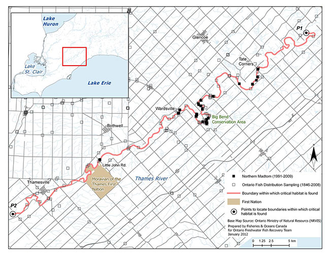
Enlarge Figure 4. Critical habitat identified for the Northern Madtom within the Thames River
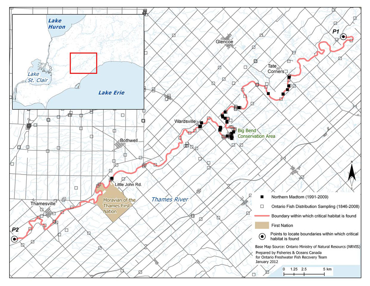
Detroit River: Critical habitat for the Northern Madtom has been identified using a population range envelope at two locations in the Detroit River: Peche Island adjacent to the eastern portion of the Windsor waterfront (Figure 5a) and at the north-east corner of Fighting Island (Figure 5b); in these locations critical habitat includes the wetted area within the envelope.
Figure 5b. Critical habitat identified for the Northern Madtom within the Detroit River near Fighting Island

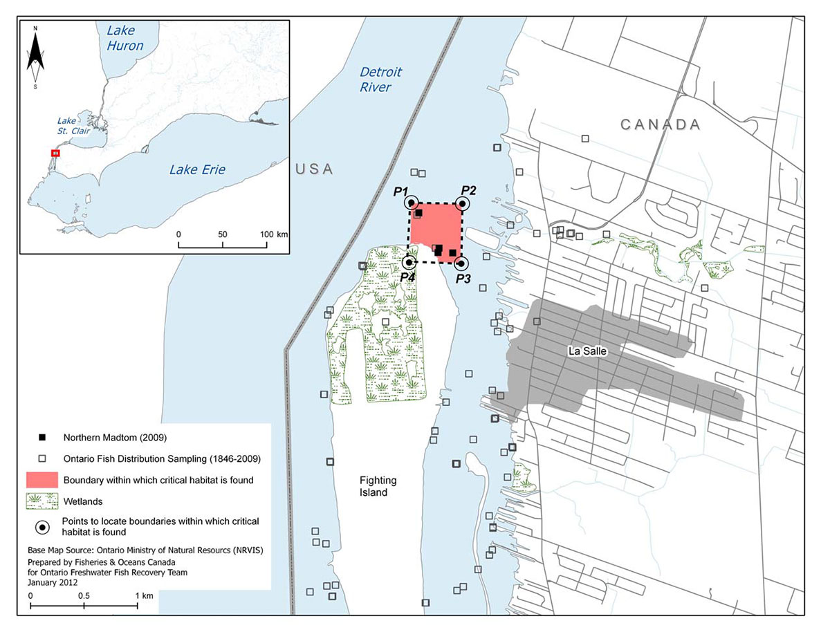
The identification of critical habitat within the Thames and Detroit Rivers will ensure that currently occupied habitat is protected, until such time as critical habitat is further refined according to the schedule of studies laid out in Section 2.7.5. The schedule of studies outlines activities necessary to refine the current critical habitat descriptions at confirmed extant locations as well as address locations with limited information (e.g., Lake St. Clair and St. Clair River). Critical habitat descriptions will be refined as additional information becomes available to support the population and distribution objectives. Until critical habitat has been fully identified, the recovery team recommends that currently occupied habitat be recognized as habitat in need of conservation for the Northern Madtom.
2.7.4.1 Population viability
Comparisons were made with the extent of critical habitat identified for each population relative to the estimated minimum area for population viability (MAPV) (Table 10). It should be noted that for some populations, it is likely that only a portion of the habitat within that identified as the critical habitat extent would meet the functional habitat requirements of the species' various life-stages. In addition, since these populations occur in areas of degraded habitat (MAPV assumes habitat quality is optimal), areas larger than the MAPV may be required to support an MVP. Future studies may help quantify the amount and quality of available habitat within critical habitats for all populations; such information, along with the verification of the MAPV model, will allow greater certainty for the determination of population viability. As such, the results in Table 10 are preliminary and should be interpreted with caution.
Table 10. Comparison of the area within which critical habitat has been identified (ha) for each Northern Madtom population, relative to the estimated minimum area for population viability (MAPV)*
| Population | Area within which critical habitat has been identified (ha) | Habitat type | MAPV (ha) | MAPV achieved (Yes/No) |
|---|---|---|---|---|
| Thames River | 320 | Riverine | 60 | Yes |
| Detroit River – Peche Island | 210 | Riverine | 60 | Yes |
| Detroit River – Fighting Island | 220 | Riverine | 60 | Yes |
1 The MAPV estimation is based on modeling approaches described above. For greater detail please refer to Matchett et al. (in press).
2.7.5 Schedule of studies to identify critical habitat
This recovery strategy includes an identification of critical habitat to the extent possible, based on the best available information. Further studies are required to refine critical habitat identified for the Northern Madtom to support the population and distribution objectives for the species. The activities listed in Table 11 are not exhaustive and it is likely that the process of investigating these actions will lead to the discovery of further knowledge gaps that need to be addressed.
Table 11. Schedule of studies to identify critical habitat
| Description of activity | Rationale | Approximate timeline |
|---|---|---|
| Conduct studies to determine the habitat requirements for each life- stage of the Northern Madtom. | There is almost no published information on the habitat requirements of YOY Northern Madtom and the habitat requirements for juvenile Madtom are unknown. Determining habitat requirements for each life-stage will ensure that all types of critical habitat for this species will be identified and further clarify the identification of significant features. | 2012-2014 |
| Survey and map habitat quality and quantity within historical and current sites, as well as sites adjacent to currently occupied habitat. | Strengthen confidence in data used to determine if sites meet the criteria to identify critical habitat; monitor current sites for changes in population data that may result in changes to critical habitat identification; surveying adjacent habitat ensures accuracy of area of occurrence, on which critical habitat is being partly defined. | 2012-2015 |
| Conduct additional Northern Madtom surveys to fill in distribution gaps, and to aid in determining population connectivity and home ranges/territories. | Limited information is available for occurrences within Lake St. Clair and St. Clair River; additional data may support the identification of critical habitat within these areas required to meet the population and distribution objectives. | 2012-2015 |
| Create a population-habitat supply model for each life-stage. | Will aid in developing recovery targets and determining the amount of critical habitat required by each life-stage to meet these targets. | 2014-2016 |
| Based on information gathered, review population and distribution goals. Determine amount and configuration of critical habitat required to achieve goal if adequate information exists. Validate population- habitat supply model and refine critical habitat descriptions as necessary. | Once the information above is gathered, recovery targets should be reviewed to ensure that they are still achievable and logical. Determining the amount and configuration of critical habitat based on recovery targets will be required for the Action Plan. | 2014-2016 |
2.7.6 Examples of activities likely to result in the destruction of critical habitat
Given that the Northern Madtom appears to tolerate a wide range of habitat conditions, it is difficult to describe with certainty those activities that are likely to result in the destruction of critical habitat. Without appropriate mitigation, direct destruction of habitat may result from work or activities such as those identified in Table 12.
The activities described in this table are neither exhaustive nor exclusive and have been guided by the general threats described in Section 1.5 of the recovery strategy for the species. The absence of a specific human activity does not preclude, or fetter the department’s ability to regulate it pursuant to SARA. Furthermore, the inclusion of an activity does not result in its automatic prohibition since it is destruction of critical habitat that is prohibited. Since habitat use is often temporal in nature, every activity is assessed on a case-by-case basis and site-specific mitigation is applied where it is reliable and available. In every case, where information is available, thresholds and limits are associated with attributes to better inform management and regulatory decision-making. However, in many cases the knowledge of a species and its critical habitat may be lacking and in particular, information associated with a species or habitat thresholds of tolerance to disturbance from human activities, is lacking and must be acquired.
Under SARA, critical habitat must be legally protected from destruction once it is identified. This will be accomplished through a SARA order, which will prohibit the destruction of the identified critical habitat unless permitted by the Minister of Fisheries and Oceans Canada pursuant to the conditions of SARA.
Table 12. Human activities likely to result in the destruction of critical habitat for Northern Madtom
The pathway of effect for each activity is provided as well as the potential links to the biophysical functions, features and attributes of critical habitat.
Physical habitat loss:
| Activity | Affect- pathway | Function affected | Feature Affected | Attribute affected |
|---|---|---|---|---|
|
Dredging Grading Excavation Structure removals (e.g., log salvage, moving of rocks in Placement of material or structures in water (e.g., groynes, piers, infilling, partial infills, jetties, etc.) |
Changes in bathymetry, shoreline and channel morphology caused by dredging and near-shore grading and excavation can alter preferred substrates, change water depths, change flow patterns potentially affecting turbidity, nutrient levels and water temperatures. Removal of in-water structure resulting from in-water activities such as dredging or infilling, can remove in-water structure used for nest building and can affect feeding success and spawning. Placing material or structures in water reduces habitat availability (e.g., the footprint of the infill or structure is lost). Placing of fill can cover preferred substrates, aquatic vegetation and underwater structure. Hardening of shorelines can reduce organic inputs into the water and alter water temperatures and flows potentially affecting the availability of habitat and/or prey for this species. |
Spawning Nursery Cover Feeding |
Currently unknown physical elements within the identified reaches of the lower Thames and Detroit Rivers |
|
Physical habitat loss or modification:
| Activity | Affect- pathway | Function affected | Feature Affected | Attribute affected |
|---|---|---|---|---|
|
Construction of dams and/or barriers Water-level management or water extraction activities |
Dams/barriers can result in direct loss of habitat or fragmentation. Altered flow patterns can affect habitat availability (e.g. by 'dewatering' habitats) in creeks and rivers, sediment deposition (e.g., changing preferred substrates), water temperatures, aquatic plant growth and prey abundance. | All or same as above | Same as above |
|
Toxic compounds:
| Activity | Affect-pathway | Function affected | Feature Affected | Attribute affected |
|---|---|---|---|---|
|
Over application or misuse of herbicides and pesticides Release of urban and industrial pollution into habitat |
Introduction of toxic compounds into habitat used by this species can change water chemistry affecting habitat availability or use, prey availability and affect aquatic plant growth affecting spawning and recruitment success. | Same as above | Same as above |
|
Nutrient loadings:
| Activity | Affect-pathway | Function affected | Feature Affected | Attribute affected |
|---|---|---|---|---|
| Over-application of fertilizer and improper nutrient management (e.g., organic debris management, wastewater management, animal waste, septic systems and municipal | Improper nutrient management can cause nutrient loading of nearby waterbodies. Elevated nutrient levels can cause increased turbidity affecting aquatic plant growth and causing harmful algal blooms potentially affecting aquatic plant growth and changing water temperatures. The availability of prey species can also be affected if prey are sensitive to organic pollution or reduced dissolved oxygen levels. | All or same as above | Same as above |
|
Siltation and turbidity:
| Activity | Affect-pathway | Function affected | Feature Affected | Attribute affected |
|---|---|---|---|---|
|
Work in or around water with improper sediment and erosion control (e.g., overland runoff from ploughed fields, use of industrial equipment, cleaning or maintenance of bridges or other structures, etc.); removal of riparian zones Unfettered livestock access to waterbodies |
Improper sediment and erosion control or mitigation can cause increased turbidity and sediment deposition, changing preferred substrates, lowering primary productivity, potentially reducing feeding success or prey availability, impacting the availability of small cavities for nesting and growth of aquatic vegetation, and possibly excluding fish from habitat due to physiological impacts of sediment in the water (e.g., gill irritation). When livestock have unfettered access to waterbodies damage to shorelines, banks and watercourse bottoms can cause increased erosion and sedimentation, affecting turbidity and water temperatures. |
All or same as above | Same as above |
|
In future, threshold values for some stressors may be informed through further research. For some of the above activities, BMPs may be enough to mitigate threats to the species and its habitat; however, in some cases, it’s not known if BMPs are adequate to protect critical habitat and further research is required.
2.8 Existing and recommended approaches to habitat protection
Northern Madtom habitat receives general protection from works or undertakings under the habitat provisions of the federal Fisheries Act. The Canadian Environmental Assessment Act (CEAA) considers the impacts of projects on all listed wildlife species and their critical habitat. During the CEAA review of a project, all adverse effects of the project on a listed species and its critical habitat must be identified. If the project is carried out, measures must be taken that are consistent with applicable recovery strategies or action plans to avoid or lessen those effects and to monitor those effects. Once identified, SARA includes provisions to prevent the destruction of critical habitat.
Provincially, protection is also afforded under the Planning Act. Planning authorities are required to be "consistent with" the provincial Policy Statement under Section 3 of Ontario’s Planning Act which prohibits development and site alteration in the habitat of Endangered or Threatened species. The Ontario Lakes and Rivers Improvement Act prohibits the impoundment or diversion of a watercourse if siltation will result. Stream-side development in Ontario is managed through floodplain regulations enforced by local conservation authorities. Habitat may also be protected under the Public Lands Act, where a permit may be required for work in the water and along the shore. The Northern Madtom is listed as an Endangered species under Ontario’s Endangered Species Act, 2007. Under the Act, the species itself is currently protected and the habitat of the Northern Madtom will be protected under the general habitat protection provisions of the Act as of June 30, 2013 unless a species-specific habitat regulation is developed by the provincial government at an earlier date.
2.9 Effects on other species
The proposed recovery actions within will benefit other native species, as they will address threats (e.g., water quality issues, pollution, habitat loss) that affect various aquatic species. Many of the stewardship and habitat improvement activities to benefit Northern Madtom will be implemented through existing ecosystem-based recovery programs that have already taken into account the needs of other species at risk.
2.10 Recommended approach for recovery implementation
The recovery team recommends a dual approach to recovery implementation which combines an ecosystem-based approach complemented by a single-species approach. The team will accomplish this by working closely with existing ecosystem-based recovery teams and other relevant organizations to combine efficiencies and share knowledge on recovery initiatives. There are four ecosystem-based recovery strategies (Essex-Erie region, Sydenham River, Thames River and Walpole Island) that address populations of Northern Madtom and are currently being implemented. These strategies incorporate the known biological and ecological requirements of Northern Madtom, address the local threats it currently faces, or could face if repatriated to historic locations, and present prioritized approaches for the species' recovery within these systems. Ecosystem strategies simultaneously employ basin-wide recovery approaches to reduce identified threats to multiple aquatic species at risk including the Northern Madtom. Populations of Northern Madtom also occur outside the boundaries of existing ecosystem-based recovery programs (i.e., Lake St. Clair, St. Clair River). As such, a single-species approach to recovery will facilitate implementation of recovery actions within these watersheds through partnerships with local watershed management and stewardship agencies. If an ecosystem-based recovery strategy is developed in the future for Lake St. Clair and/or the St. Clair River, the present single-species strategy will provide a strong foundation to build on.
2.11 Statement on action plans
Recovery action plans are documents that describe the implementation of recovery strategies. Using recommendations from the recovery strategy, action plans provide details with respect to who needs to be involved, and to what extent, in carrying out proposed activities.
One or more action plans relating to this recovery strategy will be produced within five years of the final recovery strategy being posted on the public registry. These may include multi- species or ecosystem based action plans.
3. References
Andreasen, L. and C. Springer. 2000. Hatcheries promote fish recovery. Endangered Species Bulletin 25: 32-33.
Bailey, R. and A. Yates. 2003. Fanshawe Lake ecosystem assessment and recovery strategy, background report. January, 2003. Western Environmental Science and Engineering Research Institute, Department of Biology, University of Western Ontario. 19 pp.
Bowles, J.M. 2005. Walpole Island ecosystem recovery strategy – Draft 8. Prepared for Walpole Island Heritage Centre, Environment Canada and the Walpole Island Recovery Team. vii + 43 pp.
Burr, B.M. and J.N. Stoeckel. 1999. The natural history of madtoms (genus Noturus), North America’s diminutive catfishes. Pages 51-101 in E.R. Irwin, W.A. Hubert, C.F. Rabeni, H.L. Schramm, Jr., and T. Coon, editors. Catfish 2000: proceedings of the international ictalurid symposium. American Fisheries Society, Symposium 24, Bethesda, Maryland.
Carman, S.M. 2001. Special animal abstract for Noturus stigmosus (Northern Madtom). Michigan Natural Features Inventory. Lansing, MI. 2 pp. Accessed: June 2009.
Coad, B.W. 1995. Encyclopedia of Canadian fishes. Canadian Museum of Nature, Ottawa, and Canadian Sportfishing Productions Inc., Waterdown, Ontario.
COSEWIC (Committee on the Status of Endangered Wildlife in Canada). 2002. COSEWIC assessment and update status report on the Northern Madtom, Noturus stigmosus, in Canada. Committee on the Status of Endangered Wildlife in Canada. Ottawa. vii + 15 pp.
Dextrase, A. and N.E. Mandrak. 2006. Impacts of alien invasive species on freshwater fauna at risk in Canada. Biological Invasions 18(1): 13-24.
Dextrase, A., S.K. Staton, and J.L. Metcalfe-Smith. 2003. National recovery strategy for species at risk in the Sydenham River: an ecosystem approach. National Recovery Plan no. 25. Recovery of Nationally Endangered Wildlife (RENEW): Ottawa, Ontario. 73 pp.
EERT (Essex-Erie Recovery Team). 2008. Recovery strategy for the fishes at risk of the Essex- Erie Region: an ecosystem approach. Prepared for the Department of Fisheries and Oceans. July 2008. Draft. 110 pp.
Environment Canada. 2008a. Canadian remedial action plans. Accessed: June 2009. Environment Canada. 2008b. Canadian remedial action plans – the Detroit River area of concern. Accessed: June 2009.
Environment Canada. 2008c. Canadian remedial action plans – the St. Clair River area of concern. Accessed: June 2009.
Etnier, D.A. and W.C. Starnes. 1993. The fishes of Tennessee. The University of Tennessee Press, Knoxville, Tennessee.
French, J.R.P., III and D.J. Jude. 2001. Diets and diet overlap of non-indigenous gobies and small benthic native fishes co-habiting the St. Clair River, Michigan. Journal of Great Lakes Research 27(3): 300-311.
Goodchild, C.D. 1993. Status report on the Northern Madtom, Noturus stigmosus, in Canada. Prepared for the Committee on the Status of Endangered Wildlife in Canada. 12 pp.
Goodyear, C.S., T.A. Edsall, D.M. Ormsby Dempsey, G.D. Moss, and P.E. Polanski. 1982. Atlas of the spawning and nursery areas of Great Lakes fishes. U.S. Fish and Wildlife Services: Washington, D.C. Report: FWS/OBS-82/52.
Great Lakes Information Network. 2009. Areas of concern (AOCs) in the Great Lakes region. Accessed: June 2009.
Hardman, M. 2004. The phylogenetic relationships among Noturus catfishes (Siluriformes: Ictaluridae) as inferred from mitochondrial gene cytochrome band nuclear recombination activating gene 2. Molecular Phylogenetics and Evolution 30 (2004): 395-408.
Holm, E. and N.E. Mandrak. 1998. Update status report of the Northern Madtom, Noturus stigmosus, in Canada with addendum by Alan Dextrase (OMNR) and Erling Holm (ROM), June 20, 2002. Prepared for the Committee on the Status of Endangered Wildlife in Canada. 15 pp.
Holm, E. and N.E. Mandrak. 2001. Updated status of the Northern Madtom, Noturus stigmosus, in Canada. Canadian Field-Naturalist 115(1): 138-144.
Holm, E., N.E. Mandrak, and M.E. Burridge. 2009. The ROM field guide to freshwater fishes of Ontario. Royal Ontario Museum Science Publication. Toronto, Ontario. 462 pp.
Jansen, J. and D.J. Jude 2001. Recruitment failure of Mottled Sculpin, Cottus bairdii, in Calumet Harbor, southern Lake Michigan, induced by newly introduced Round Goby, Neogobius melanostomus. Journal of Great Lakes Research 27(3): 319-328.
Lane, J.A., C.B. Portt, and C.K. Minns. 1996. Nursery habitat characteristics of Great Lakes fishes. Canadian Manuscript Report of Fisheries and Aquatic Sciences 2338: v + 42 pp.
Lemmen, D.S. and F.J. Warren. 2004. Climate change impacts and adaptation: a Canadian perspective. Natural Resources Canada: Ottawa, Ontario.
MacInnis, A.J. 1998. Reproductive biology of the Northern Madtom, Noturus stigmosus (Pisces: Ictaluridae) in Lake St. Clair. Canadian Field-Naturalist 112(2): 245-249.
MacInnis, A.J. and L.D. Corkum. 2000. Fecundity and reproductive season of the Round Goby Neogobius melanostomusin the upper Detroit River. Transactions of the American Fisheries Society 129: 136-144.
Matchett, S.P., J.A.M. Young and M.A. Koops. In press. Recovery potential modelling of Northern Madtom (Noturus stigmosus) in Canada. DFO Can. Sci. Advis. Sec. Res. Doc. 2012/nnn. iv + 21 pp. NatureServe. 2009. NatureServe Explorer: An online encyclopedia of life [web application]. Version 7.1. NatureServe, Arlington, Virginia. Accessed: February 2009.
Ontario Ministry of the Environment. 2009. 2008 water quality in Ontario report. Publication 6926e
Poos, M., A.J. Dextrase, A.N. Schwalb, and J.D. Ackerman. 2010. Secondary invasion of the Round Goby into high diversity Great Lakes tributaries and species at risk hotspots: potential new concerns for endangered freshwater species. Biological Invasions 12(5):1269-1284.
Shute, J.R., P.L. Rakes, and P.W. Shute. 2005. Reintroduction of four imperiled fishes in Abrams Creek, Tennessee. Southeastern Naturalist 4(1): 93-110.
Simonson, T.D. and R.J. Neves. 1992. Habitat suitability and reproductive traits of the orangefin madtom, Noturus gilberti (Pisces: Ictaluridae). American Midland Naturalist 127: 114-124.
Taylor, W.R. 1969. A revision of the catfish genus NoturusRafinesque, with an analysis of higher groups in the Ictaluridae. U.S. National Museum Bulletin 282: 1-315.
The Thames River Ecosystem Recovery Team (TRERT). 2004. The Thames River watershed: synthesis report. 70 pp.
The Thames River Recovery Team (TRRT). 2005. Recovery strategy for the Thames River aquatic ecosystem: 2005-2010. November 2005 draft. 146 pp.
Thomas, M.R. and B.M. Burr. 2004. Noturus gladiator, a new species of madtom (Siluriformes: Ictaluridae) from Coastal Plain streams of Tennessee and Mississippi. Ichthyological Exploration of Freshwaters 15(4): 351-368.
Thomas, M.V. and R.C. Haas. 2004. Status of the Lake St. Clair fish community and sport fishery, 1996-2001. State of Michigan Department of Natural Resources, Fisheries Division and Research Report 2067.
Trautman, M.B. 1981. The fishes of Ohio with illustrated keys. Ohio State University Press, Columbus, Ohio. 78 pp.
U.S. Environmental Protection Agency. 2009. Great Lakes area of concerns. Accessed: June 2009.
U.S. Geological Survey. 2006. Belle Isle Sturgeon Habitat Project, Post-construction Monitoring, Week 6 of 2006. Accessed: September 2007.
Vélez-Espino, L.A., R.G. Randall, and M.A. Koops. 2010. Quantifying habitat requirements of four freshwater species at risk in Canada: Northern Madtom, Spotted Gar, Lake Chubsucker, and Pugnose Shiner. DFO Can. Sci. Advis. Sec. Res. Doc. 2010/115. iv + 20 pp.
Wildhaber, M.L., A.L. Allert, C.J. Schmidt, V.M. Tabor, D. Mulhern, K.L. Powell, and S.P. Sowa. Natural and anthropogenic influences on the distribution of the threatened Neosho madtom in a Midwestern warmwater stream. Transactions of the American Fisheries Society 129: 243-261.
Woolnough, D.A., J.A. Downing, and T.J. Newton. 2009. Fish movement and habitat use depends on water body size and shape. Ecology of Freshwater Fish 18(1): 83-91.
4. Recovery team members
The following members of the Ontario Freshwater Fish Recovery Team were involved in the development of the recovery strategy for the Northern Madtom:
Shawn Staton (Chair) - Fisheries and Oceans Canada
Dave Balint - Fisheries and Oceans Canada
Mathew Child - Essex Region Conservation Authority
Alan Dextrase - Ontario Ministry of Natural Resources
Amy Edwards - Fisheries and Oceans Canada
Trevor Friesen - Ontario Ministry of Natural Resources
Brian Locke - Ontario Ministry of Natural Resources
Dr. Nicholas E. Mandrak - Fisheries and Oceans Canada
Mike Nelson - Essex Region Conservation Authority
Dr. Scott Reid - Ontario Ministry of Natural Resources
John Schwindt - Upper Thames River Conservation Authority
Dr. Daelyn Woolnough - Central Michigan University (formerly Trent University)
Appendix 1. Record of cooperation and consultation
The proposed recovery strategy for Northern Madtom (initiated in 2007) was prepared by Fisheries and Oceans Canada (DFO) with input from representatives of the Ontario Ministry of Natural Resources (OMNR), Essex Region Conservation Authority, Upper Thames River Conservation Authority and Trent University. Members of existing ecosystem-based recovery teams (Thames River and Essex-Erie region) were invited to participate in the development of this recovery strategy. Members included representatives from federal and provincial governments, academic institutions, conservation authorities and First Nations groups/agencies (including Six Nations EcoCentre, Oneida Nation of the Thames, Southern First Nations Secretariat, Chippewas of the Thames, Delaware Nation and Munsee-Delaware First Nation).
DFO has attempted to engage all potentially affected Aboriginal communities in southern Ontario during the development of this proposed recovery strategy. In 2007, information packages were sent to Chief and council of Aamjiwnaang First Nation, Caldwell First Nation, Chippewa of the Thames First Nation, Oneida Nation of the Thames, Moravian of the Thames First Nation, Munsee Delaware Nation and Walpole Island First Nation. Information packages were also sent to the Métis Nation of Ontario, Grand River Métis Council, Windsor/Essex Métis Council and Métis Captain of the Hunt Region 9. The following Aboriginal organizations also received information packages: Southern First Nation Secretariat, Association of Iroquois and Allied Indians, Chiefs of Ontario, Assembly of First Nations and the Union of Ontario Indians. Members of these communities may have travelled or harvested fishes from the waters where the Northern Madtom was historically found. Follow-up telephone calls were made to each community office to ensure that packages were received and to ask if they would like to schedule a meeting to learn more about species at risk in general and the proposed recovery strategy in particular. As a result of these letters and calls, no requests for meetings and no comments were received.
In March 2011, DFO conducted community consultation sessions with Walpole Island First Nation (in coordination with Environment Canada and Parks Canada Agency) on several recovery documents, including the present recovery strategy. Feedback and written comments were received for consideration.
Although many Aboriginal and Métis communities already received a letter from DFO (in November 2007) regarding a recovery strategy for the Northern Madtom, given the passage of time and the addition of critical habitat to the recovery strategy, a new letter will be sent to First Nations to invite their comments on the updated strategy. This letter will be sent in advance of the proposed recovery strategy being posted on the SARA Registry.
DFO has prepared a list of non-government organizations and municipalities which may be impacted by the proposed recovery strategy. Information packages have been prepared to inform these groups that the proposed recovery strategy is about to be approved and invites each group to comment on the strategy. A letter has been prepared to request further provincial comment on the proposed recovery strategy and has been sent to the OMNR. As well, an announcement has been prepared and will be placed in newspapers with circulation in the area where the Northern Madtom was historically found to inform landowners and the general public about the proposed recovery strategy and to request their comments. These packages will be sent and the announcements published at the time the proposed recovery strategy is posted on the SAR registry.
Footnotes
- footnote[1] Back to paragraph Draft Policy on the Feasibility of Recovery, Species at Risk Act Policy. January 2005.