O'Connor Conservation Reserve Management Statement
This document provides policy direction for the protection, development and management of the O'Connor Conservation Reserve and its resources.
O'Connor Conservation Reserve (C294)
Statement of Conservation Interest
Ministry of Natural Resources
Algoma Area
Sault Ste. Marie District
March 3, 2003
Ce document est seulement disponsible en anglais.
Approval statement
I am pleased to approve this Statement of Conservation Interest (SCI) for the O'Connor Conservation Reserve (C294), prepared by Joey Young and Gerry Morin.
O'Connor Conservation Reserve captures rugged terrain covered by a dense forest canopy. The site protects mature sugar maple, yellow birch and red maple mixed-wood communities with pockets of mature white pine, black spruce, white spruce and white birch. In addition to the mature stands, younger mixed stands of sugar maple and white birch abound. All forest types are underlain by a variety of geological formations. Regulated on December 21, 2000, this 895-hectare conservation reserve is situated approximately 60 kilometres north of the City of Sault Ste. Marie, in Grenoble and Dablon Townships.
Direction for establishing, planning and managing conservation reserves is defined under the Public Lands Act and current policy. The direction for managing this conservation reserve is in the form of a SCI, which defines the area that is being planned, provides the purpose for which the conservation reserve has been proposed, and outlines the Ministry of Natural Resources' intent for the protected area. This SCI will provide both guidance for the management of the conservation reserve and the basis for ongoing monitoring of activities. More detailed direction at this time is not anticipated. However, should significant facility development be considered or complex issues arise requiring additional studies, more detailed management direction will be prepared with full public consultation, in the form of special protection measures, or a detailed Resource Management Plan.
Public and Aboriginal consultation occurred prior to the regulation of this conservation reserve during the planning for Ontario’s Living Legacy. Furthermore, there was a 15-day review period in November 2002 concerning a draft of this SCI. Comments from the review period have been considered in the development of this document.
This SCI will be implemented by the Algoma Area Supervisor, and will be reviewed every five years and amended as required by the District Planner, Sault Ste. Marie District, Ministry of Natural Resources.
Submitted by:
Erin Nixon
Date: February 21, 2003
Recommended
For Approval by:
Serge Tenaglia R.
District Manager
Sault Ste. Marie District
Date: March 04, 2003
Approved by:
Rob Galloway
Regional Manager
Date: March 30, 2003
1.0 Introduction
The following document is a Statement of Conservation Interest (SCI) for O'Connor Conservation Reserve (C294). The purpose of this SCI is to identify and describe the natural, recreational and cultural values of O'Connor Conservation Reserve and to outline the Ministry of Natural Resources' management intent for this area. The first portion of this document highlights the provincial context in which it was produced, states its goal and objectives, and summarizes the planning process for conservation reserves. The second portion of this document is specific to O'Connor Conservation Reserve. Management direction provided within this SCI will serve to protect the conservation reserve for the benefit of all Ontario residents. This direction will comply with the land use intent stated in the Ontario’s Living Legacy Land Use Strategy (OMNR 1999).
1.1 Provincial context
Ontario’s network of natural heritage areas has been established to protect and conserve areas representative of the diversity of the natural regions of the province, including species, habitats, features and ecological systems which comprise that natural diversity. Protected natural heritage areas are a key component in the sustainable management of natural resources. They ensure that representative sites within the larger managed landscape are permanently retained in their natural state. O'Connor Conservation Reserve is part of Ontario’s network of natural heritage areas.
On July 16, 1999, the Ontario Government released the Ontario’s Living Legacy Land Use Strategy to guide the planning and management of Ontario’s Crown lands. Extensive consultation was conducted during the development of the Land Use Strategy. The objectives of the Land Use Strategy are to complete Ontario’s system of parks and protected areas; recognize the land use needs of the resource-based tourism industry; provide forestry, mining and other resource industries with greater certainty around land and resource use; and enhance hunting, angling and other Crown land recreation opportunities.
The Land Use Strategy (OMNR 1999) demonstrated the government’s commitment to completing Ontario’s system of protected natural heritage areas by designating 378 new areas to be protected. These areas are considered to be significant and require protection from incompatible activities in order for their values to endure over time. The addition of these 378 new areas marks the largest expansion of parks and protected areas in Ontario’s history. O'Connor Conservation Reserve was created as part of this expansion. It protects old-growth white pine (Pinus stobus L.) and mature sugar maple (Acer saccharum Marsh.) and yellow birch (Betula alleghaniensis Britt.) mixed-wood communities, in association with a bedrock-drift complex.
The Ministry of Natural Resources has established conservation reserves as a tool to protect natural heritage areas on public lands, while permitting traditional public land uses to continue. These uses include recreation activities, such as hunting and fishing, and the traditional activities of Aboriginal societies as defined under applicable Aboriginal Treaties. Lands designated as conservation reserves in the Land Use Strategy (OMNR 1999) are removed from Sustainable Forest Licence, and mining and surface rights are withdrawn from staking under the Mining Act (RSO 1990 Chapter M.14).
Ontario’s Living Legacy Land Use Strategy (OMNR 1999) outlines the general land use policy and management direction for new conservation reserves. Each new conservation reserve will have a planning document, either a SCI or, in more complex situations, a Resource Management Plan, that details site-specific management direction.
2.0 Goal and objectives of the SCI
2.1 Goal
The goal of this SCI is to provide the framework and the direction to guide management decisions affecting O'Connor Conservation Reserve.
2.2 Objectives
The following objectives are identified as the means to achieve the above stated goal:
- To describe the state of the resource with respect to the values identified in Section 5.0 and current land use activities
- To outline the Ministry of Natural Resources' management intent for the protected area
- To determine the land use compatibility of current land uses, and to develop specific guidelines and prescriptions to manage these uses
- To create public awareness of the values, as per Section 5.0, within this conservation reserve by providing information on the resources that it contains and protects; and to promote responsible stewardship of the protected area through partnerships with local stakeholders
- To determine the long-term management goals for the conservation reserve by identifying research, client services, and marketing strategies necessary to position this conservation reserve among the system of parks and protected areas in Ontario
- To identify the scientific values on the site in relation to provincial benchmarks and identify the necessary monitoring and/or research to maintain the integrity of those values
- To provide direction for the evaluation of proposed new uses or economic ventures through the application of the Test of Compatibility (Appendix A). This test will evaluate the impact of suggested use(s), either positive or negative, on the protected values of the conservation reserve
3.0 Management planning
3.1 Planning for a Conservation Reserve
The planning process for a conservation reserve consists of defining site boundaries and preparing a site specific management plan. Public, Aboriginal and industry consultations occur during the planning process. When the boundaries of the site are finalized and the Ministry of Natural Resources' approval process is complete, a conservation reserve becomes regulated. Once a conservation reserve is regulated, the level of management planning required to fulfil the protection targets is determined, and either a basic or an enhanced SCI or a Resource Management Plan is prepared. A basic SCI is prepared when land use direction follows the direction laid out in the Ontario’s Living Legacy Land Use Strategy (OMNR 1999). An enhanced SCI is prepared when minor variations to the direction occurs, beyond those mentioned in the Strategy. A Resource Management Plan is prepared in more complex situations where a number of issues have to be addressed. Whichever the determination, the plan must be completed within three years of the conservation reserve’s regulation date. The guidelines for the preparation of these documents are provided in Procedural Guideline A- Resource Management Planning (Conservation Reserves Procedure PL3.03.05, Public Lands Act).
A SCI is essentially a management plan based on the management direction provided in the Land Use Strategy (OMNR 1999). The purpose of a SCI is to identify the State of the Resource with respect to the values outlined in Section 5.0 and current land use activities, and to outline the Ministry of Natural Resources' management intent for the conservation reserve. SCIs is typically go through a public review period of 15 days. Upon completion of this public review, the SCI is revised as appropriate and approved by the Ministry of Natural Resources' Regional Director.
Existing permitted uses within conservation reserves may continue, unless they are shown to have a significant negative impact on the values protected by the site. A review/evaluation mechanism is in place to address proposed new permitted uses, or land use proposals. The Test of Compatibility (Appendix A) as outlined in the Public Lands Act Policy PL 3.03.05 (OMNR 1997) and/or other standard Ministry of Natural Resources' environmental screening processes, is used to screen future proposals. Where cultural resources may be impacted, proposals may be screened through Conserving a Future for our Past: Archaeology, Land Use Planning & Development in Ontario, Section 3 (MCzCR 1997), in a manner similar to that used by the Ministry of Natural Resources in the forest management planning process.
Public comment may be solicited during a review of any future land use proposals that require new decisions to be made. Appropriate environmental assessment (EA) requirements and amendment processes will apply to any future proposal and/or any significant change in management direction being considered for a site.
3.2 Planning process for the O'Connor Conservation Reserve
O'Connor Conservation Reserve (C294) was designated as a conservation reserve in the 1999 Ontario Living Legacy Land Use Strategy, by the Ontario Ministry of Natural Resources. Public, Aboriginal and industry consultations have taken place and the boundary of the site has been finalized. The site was formally regulated through an amendment to Ontario Regulation 805/94 of the Public Lands Act on December 21, 2000, by Ontario Regulation 686/00.
To date, no significant issues related to land use in this area have been identified. For this reason, it was determined that a basic SCI will adequately identify the conservation reserve’s significant features and address the management guidelines. Therefore, the O'Connor Conservation Reserve will be managed under the auspices of a SCI. It should be noted this SCI addresses only those issues or land use proposals currently known to the District Manager. The direction provided by this SCI, and future management decisions, will resolve any future land use conflicts and will ensure that identified values continue to be adequately protected.
3.2.1 Planning area
The planning area for this SCI consists of the regulated boundary for O'Connor Conservation Reserve (see Section 10.0, Map 1). However, to fully protect values within the conservation reserve, additional consideration within larger land use planning initiatives may be required. The forest management planning process is an example of how adjacent land management may consider sensitive features within the conservation reserve boundary.
3.3 Guiding principles
All current or planned activities within this conservation reserve should be in compliance with the following guiding principles. If a conflict between management guidelines exists, the following guiding principles will be used to discern management intent and resolve the issue.
- All management guidelines will be based on maintaining the long-term ecological integrity of the area
- No new or existing uses will be permitted if it is deemed that the protected natural heritage values will be compromised
- All attempts will be made to maintain traditional uses while protecting values, as per Section 5.0, and maintaining the long-term ecological integrity of the site
- This conservation reserve was chosen to represent vegetation and landscape types unique to this site district and to Ontario. All efforts will be made to maintain those values identified in Section 5.0
- Overall, management strategies will focus on maintaining the conservation reserve in as natural a state as possible
4.0 Background information
4.1 Location and site description
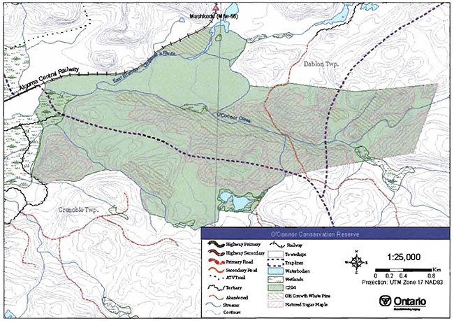
O'Connor Conservation Reserve is located approximately 60 km north of the City of Sault Ste. Marie, in Grenoble and Dablon Townships (see Section 10.0, Map 1a). Whenever possible, natural and/or artificial features have been used to delineate site boundaries to facilitate easy, on-theground identification of the boundaries. The northwestern boundary of the conservation reserve is defined by a section of the Algoma Central Railway line. The conservation reserve’s southern boundary generally follows unnamed streams. The eastern boundary of the conservation reserve is primarily vectored, that is, straight lines are used between more identifiable features, such as a fork in a stream, a bend in a road or the peak of a hill.
O'Connor Creek, a tributary of the east branch of the Chippewa River, bisects the conservation reserve in an easterly direction. This occurs near the railroad tracks beginning at Mashkode at Mile 56, and continues southwest to the forest plantation that borders the site on the western edge.
Road access to the conservation reserve is limited. One road approaches the western boundary, but appears to be overgrown by vegetation within the site itself. A second road seems to enter the conservation reserve from the east off of the Whitman Dam Road, but its condition is uncertain. For a more detailed description of these roads, please refer to Section 5.3. Although the Algoma Central Railway line forms the northwest boundary, upon exiting the train, one must cross the Chippewa River to access the conservation reserve. Also, the rugged topography and mostly roadless terrain make access to the interior of the site more challenging.
Table 1 describes the location and administrative details of the site.
Table 1. Location and administrative details for the O'Connor Conservation Reserve.
| Name | O'Connor Conservation Reserve (C294) |
|---|---|
| Site Region - Site District (Hills 1959) | 4E-2 Batchawana |
| Site region - Site District (Crins and Uhlig 2000) | SE-13 |
| OMNR Administrative | Northeast Region/Sault Ste. Marie |
| Region/District/Area | District/Algoma Area |
| UTM co-ordinates | 264574 E, 5210625 N |
| SCI Completed | January 10, 2003 |
| Regulated | December 21, 2000 |
| Area | 898 ha |
| Nearest Town/Municipality | Approximately 60Km north of the City of Sault Ste. Marie |
| Township(s) | Grenoble and Dablon |
| OBM Numbers | 2016710052100, 2016720052100, 2016710052000 2016720052000 |
| Typographical Map Name/Number | 41 N/1 Batchewana |
| Wildlife Management Unit | 35 |
| Forest Unit | Algoma |
| Watershed | Lake Superior Basin |
4.2 History of the site
O'Connor Creek, the small river bisecting the conservation reserve, lends its name to O'Connor Conservation Reserve. The history surrounding this conservation reserve is strongly linked to the Algoma Central Railway line that forms the site’s western boundary.
During the early 1900s, the railway tracks were bustling with activity. Trees of all species were cut for varying purposes. Horses hauled the logs down to the rail line during the frozen winter months. In 'Forest Tracks Mile by Mile' (2000), Vosper states the trains delivered white pine to mills located south of O'Connor Conservation Reserve in the Searchmont area and hardwoods were shipped to mills in Sault Ste. Marie. The 1903 financial collapse of the Consolidated Lake Superior Corporation, saw track laid as far as Mile 56, Mashkode, a site just north of the conservation reserve. Continued construction of the rail line was very slow until 1910, when a refinanced company began to actively push steel north once again. During this time, a short-lived charcoal plant was constructed near the town of Searchmont. The plant was designed to utilize 25 acres (10 hectares) of forest daily to be processed into the charcoal required to fire the blast furnaces of the new steel mill located in Sault Ste. Marie (Vesper 2000). It is assumed that the O'Connor Conservation Reserve was logged to feed the nearby charcoal plant, as this site was the terminus for the tracks during the life span of the charcoal plant. More recently, during the mid-1980s, much of the conservation reserve and surrounding area was selectively harvested for sugar maple (M. Thompson pers. comm.).
4.3 Inventories
Table 2 indicates the current status of natural heritage inventory that has occurred and/or is required for O'Connor Conservation Reserve.
Table 2: Inventory and Survey Information for the O'Connor Conservation Reserve.
| Survey Level | Earth Science | Life Science | Cultural | Recreational |
|---|---|---|---|---|
| Reconnaissance | Fall 2001 | Fall 2001 | Fall 2001 | Fall 2001 |
| Detailed | Not required | Detailed life science Not required Not required inventory should be completed to assess the representation of the site within the region and Ontario. | Not required | Not required |
| Further Requirements | An assessment should be completed to determine if any Species At Risk occur within O'Connor Conservation Reserve. | A detailed inventory should be completed of the location and condition of any roads or trails approaching or within the conservation reserve. |
5.0 State of the resource
Interpretation of 1994 air photos indicates that O'Connor Conservation Reserve is in good condition and appears largely undisturbed. An aerial reconnaissance survey completed in 2001 by the Ministry of Natural Resources, and a ground site visit in 2002, showed no observable human disturbances despite records showing selective harvesting for hardwood during the 1980s. Further cross-reference also indicates extensive logging likely occurred throughout the area during the early 1900s. Please refer to Section 4.2 for more historical information.
The condition of the surrounding land is also considered to be healthy and there is good connectivity to stands beyond the site’s boundaries to the north, east and south. To the west and northwest, some fragmentation is evident due to the Algoma Central Railway tracks and a conifer plantation. While both of these features provide well-established cultural boundaries, they also artificially separate the site from the more westerly, naturally established forest communities and result in ecological fragmentation.
Sections of this conservation reserve’s boundaries that have been vectored tend to cut through/across natural features (landforms, wetlands, forest stands). The features in these circumstances extend beyond the boundary of the protected area. Due to these artificial delineations and the site’s small size, long term management and protection of key values may be challenging.
The key values (geological features and/or featured species) found within O'Connor Conservation Reserve include the following:
- Stands of old-growth white pine and mature sugar maple
The key values are those values that make this site unique and have led to its designation as a conservation reserve. Their protection is paramount. Additional values as listed in Section 5.1 through to Section 5.5 are also important. This description is not necessarily complete. If new values are identified, they will be added to this section. If any new value is considered significant, management guidelines may be modified, if required, to ensure its protection.
5.1 Earth sciences
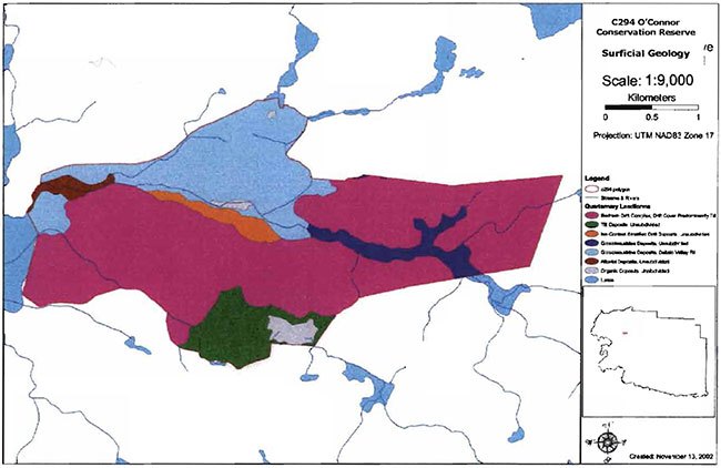
O'Connor Conservation Reserve is located in a scenic area of Ontario. Situated approximately 25 kilometres inland from the Lake Superior coastline, this site falls within the Batchawana Site District 4E-2 (Hills 1959). This site district is known for its rugged topography, underlain by the massive to foliated granitic rocks associated with Superior Province of the precambrian shield (Kristjansson 2002, in prep.). The bedrock uplands are characterized by a thin layer of sandy soil on the upper slopes and deeper soils in the valleys (Ciergue Forest Mgmt. and OMNR, 2000). Kristjansson (2002, in prep.) has completed an assessment of landform features within the O'Connor Conservation Reserve, based on air-photo interpretation. The southern section of the conservation reserve is considered to be bedrock-drift complex while glaciolacustrine deposits dominate the northern tip (see Section 10.0, Map 2). In all, six major landform features are protected within this conservation reserve. These include bedrock-drift complex, ice-contact stratified drift deposits, organic deposits, glaciolacustrine deposits of silt and clay, till deposits, and alluvial deposits (Thompson et al. 2002).
5.2 Life sciences
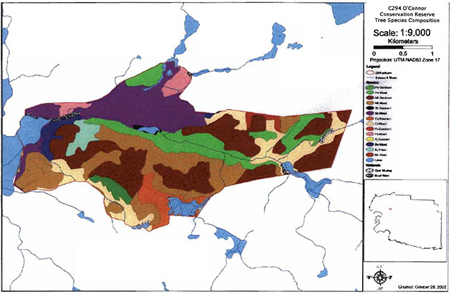
Stands of sugar maple with mixed stands of black spruce (Picea mariana Miller), white cedar (Thuja occidentalis L.) and white pine dominate the forests of O'Connor Conservation Reserve (Thompson et al. 2002). In the southwest section, hilltops are dominated by a pure blend of sugar maple and white birch (Betula papyrifera Marsh.) mixed-wood. White spruce (Picea glauca Moench), balsam fir (Abies balsamea (L.) Mill.), poplar (Populus spp.) and white birch are also present throughout the site (see Section 10.0, Map 3).
Some of the white pine stands found within the conservation reserve are considered to be old growth. These stands range in age from 120-149 years old and are located on south-facing slopes (Thompson et al. 2002). In addition to these old-growth white pine stands, mature sugar maple stands are found throughout the conservation reserve (see Section 10.0, Map 3).
O'Connor Creek bisects the conservation reserve. Vegetation located adjacent to the creek consists mainly of alder (Alnus spp.) thickets mixed with tall shrub fen (Thompson et al. 2002). White pine, black spruce, yellow birch and white cedar mixed-wood communities dominate the bank vegetation. The conservation reserve also protects wetland complexes ranging from small areas of meadow marsh and beaver meadow to spruce bog and coniferous swamp (Thompson et al. 2002).
O'Connor Conservation Reserve is located within Site District 4E-2. This site district is known to be potential habitat for provincially significant species including the wood turtle (Ciemmys insculpta), bald eagle (Haliaeetus leucocephalus), long-eared owl (Asio otus) and braun’s holly fern (Polystichum braunii). To date, the occurrence of these species within the conservation reserve remains unknown.
Both the Chippewa River and O'Connor Creek contain native populations of brook trout (Salvelinus fontinalis) (R. Knudsen, pers. com.). No artificial dams are known to exist within or upstream of the conservation reserve.
5.3 Recreational values
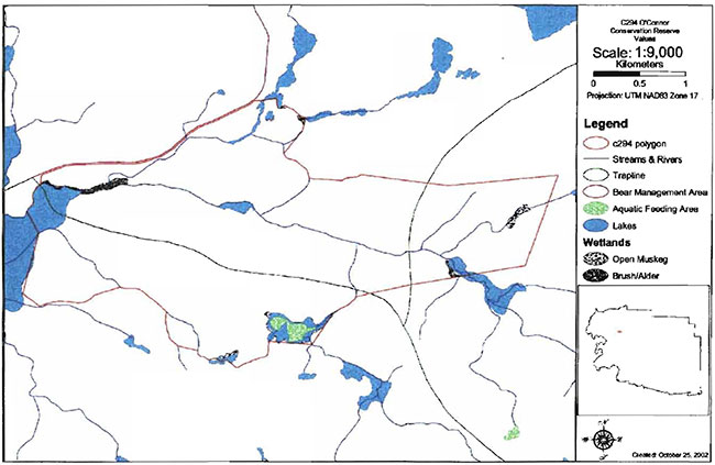
Vehicular road access to this conservation reserve is somewhat limited. Access to the conservation reserve may be attained from the Algoma Central Railway line, or from an old tertiary road that straddles the tracks and enters the area from the west (see Section 10.0, Map 4). This road branches off of the McDonald Creek Road and leads to the plantation area south of the railway tracks and to the western boundary of the site. Currently beavers are active in several locations along this road causing numerous washouts. With no crossing installed at the tracks and the bridge over the east branch of the Chippewa River in a state of disrepair, access via this route is hazardous (G. Morin pers. comm.). An assessment should be conducted to determine whether this road enters the conservation reserve. Another abandoned road, originating at the Whitman Dam Road east of the site, approaches the conservation reserve from south of Trout Lake. A part of this old road forms a small segment of the northeast boundary. From the boundary, it appears to continue southward through the conservation reserve. However, neither the continued existence nor the condition of this road has been assessed. Once inside the conservation reserve, with the proper navigation tools, exploring is relatively easy. The understory amid the hardwoods is sparse and many prominent forest stand types and landmarks exist.
Aesthetic features such as the Chippewa River and O'Connor Creek, high elevation ridges that provide grand vistas, and mature to old-growth forest stands combine to enhance the beauty and the recreational potential of this conservation reserve. Opportunities for off-trail hiking, crosscountry skiing and snowshoeing exist in concert with activities such as photography, bird and wildlife viewing, fishing, hunting and camping.
Little recreational activity is known to occur within O'Connor Conservation Reserve. Some hunting may take place, as access to the periphery of the conservation reserve can be obtained with an all-terrain-vehicle (ATV). However, the absence of good quality trails creates obstacles to travel within the reserve as well as for game retrieval.
5.4 Cultural values
This site falls within the Robinson-Huron treaty area. To date, no First Nation community has identified any specific cultural values within this conservation reserve.
5.5 Research values
Currently no known research and/or monitoring activities have occurred within this conservation reserve.
6.0 Management guidelines
All management guidelines in this SCI are based on policy and direction outlined in the Ontario Living Legacy Land Use Strategy (OMNR, 1999) and associated policy clarification statements. Management policies in this document may be subject to change and may be amended as necessary. These guidelines are specific to O'Connor Conservation Reserve, and provide for protection of the site’s unique features.
New proposals for uses and development as well as research and education will be reviewed on a case-by-case basis. The Test of Compatibility (Appendix A-PL 3.03.05, Public Lands Act) must be passed with reference to Conserving a Future for our Past: Archaeology, Land Use Planning & Development in Ontario, Section 3 (MCzCR 1997) before new proposals will be permitted. In addition, all new proposals are subject to the Class Environmental Assessment for Parks and Conservation Reserves.
The following management strategies have been created to achieve the goal and objectives of O'Connor Conservation Reserve’s SCI.
6.1 Industrial activities
6.1.1 Commercial Timber Harvest
The area contained within this conservation reserve (895 ha) has been withdrawn from the Algoma Sustainable Forest License area and no commercial timber harvesting will be permitted. Please refer to Section 6.4.3 for information regarding non-commercial wood harvesting.
6.1.2 Mining and mineral exploration
There are no known current mining interests within this conservation reserve. Mining and surface rights within the conservation reserve’s boundaries have been withdrawn from staking under the Mining Act (RSO 1990 Chapter M.14). Mineral exploration is not permitted.
6.1.3 Extraction of peat, soil, aggregate and other material
Extraction of peat, soil, aggregate and other materials is not permitted.
6.1.4 Energy generation
Hydropower development and wind power generation is not permitted within the conservation reserve.
6.2 Existing and proposed development
6.2.1 Transportation corridors
6.2.1.1 Roads
Road access to the conservation reserve is limited. An old tertiary road branching off of the McDonald Creek Road leads to the plantation area south of the railway tracks and to the western boundary of the site. Currently beavers are active in several locations along this road causing numerous washouts. With no crossing installed at the tracks and the bridge over the east branch of the Chippewa River in a state of disrepair, access via this route is hazardous (G. Morin pers. comm.). An assessment should be conducted to determine whether this road enters the conservation reserve. Another abandoned road, originating at the Whitman Dam Road east of the site, approaches the conservation reserve from south of Trout Lake. A part of this old road forms a small segment of the northeast boundary. From the boundary, it appears to continue southward through the conservation reserve. However, neither the continued existence nor the condition of this road has been assessed.
Existing Crown roads that may be contained within this conservation reserve are permitted to continue but will not be maintained by the Ministry of Natural Resources. Maintenance by area users may be permitted, subject to appropriate approvals to ensure the protected values of the site are not compromised. Should protected values of the site be compromised, the Ministry of Natural Resources may consider appropriate provisions under the Public Lands Act to ensure their protection.
According to the Land Use Strategy (OMNR, 1999), new roads for resource extraction will not be permitted, except those identified in Forest Management Plans prior to March 31, 1999 and for which no viable alternative exists. No new or existing roads for resource extraction were identified within this site.
6.2.1.2 Trails
Currently, no Voyageur Trail Association or Ontario Federation of Snowmobile Clubs trails have been identified within this conservation reserve. Any future trail development must consider the conservation reserve’s core values, specifically the earth science features that are protected within the boundaries of this site. Trail development in low-lying areas and wetlands will be discouraged as will trail development over shallow soils on rock outcrops and the fragile vegetation that grows on these sites. Any proposed new trails will be subject to the district work permit review process and the Test of Compatibility screening process (Appendix A). All new and existing trail heads and trail routes must be identified using new technologies (i.e. global positioning systems) to ensure the most accurate record of the feature. If new trails are approved, an amendment to this SCI will occur.
6.2.2 Other corridor development/maintenance
No communication, energy transmission, or other non-road corridors have been identified within this conservation reserve. New corridor developments will be actively discouraged through planning. Proposals for new corridors will be subject to the Test of Compatibility (Appendix A) and other applicable district policies.
6.2.3 Land disposition
No land will be sold within the boundaries of this conservation reserve.
6.2.4 Land Tenure
Presently, no land use permits (LUPs) or leases exist within this conservation reserve. With the exception of private recreation camps, new leases or land use permits may be issued for other approved uses, subject to the Test of Compatibility (Appendix A) and applicable district policy. These forms of land tenure will neither be patented nor phased out but may be eligible for enhanced tenure or transfer. Enhanced tenure is defined as anything beyond the term and form of current tenure. All requests for transfer or enhanced tenure will be subject to the following screening criteria:
- Is the transfer or enhanced tenure consistent with the conservation reserve’s land use intent, which is the protection and enhancement of the site’s natural, recreational and cultural values?
- Is it consistent with the land disposition policies outlined in the District Land Use Guidelines, this SCI and any other applicable document?
- Does it adversely affect protected the values as identified in Section 5.0, and/or conflict with other uses?
- Is land needed by the Crown to protect significant natural or recreational values outlined in this SCI?
- Does the transfer or enhanced tenure conflict with Aboriginal traditional uses, land claims or agreements?
- Are all rents, taxes, fees, rates or charges paid up for the existing LUP or lease?
6.3 Commercial activities
6.3.1 Commercial bait harvesting
One commercial bait harvest operation currently exists in Grenoble Township on the west side of O'Connor Conservation Reserve. No active commercial bait harvest operations currently exist in Dablon Township in the east section of this site. New bait harvest operations in the unallocated portion of the conservation reserve in Dablon Township may be considered subject to a Test of Compatibility (Appendix A) and applicable District policies.
Under the Public Lands Act and in conjunction with PL 3.03.08 "Buildings for Bait Harvesting Management", cabins for the purposes of bait harvesting may be constructed on Crown land. However, the construction of such buildings within this conservation reserve should be avoided, and be directed to Crown land outside the protected area wherever possible.
6.3.2 Commercial fishing
There are no commercial fisheries within this conservation reserve.
6.3.3 Commercial fur trapping
Portions of the registered trapline areas SS21, SS26, and SS27 fall within the boundary of this conservation reserve. These registered trapline areas are currently allocated to head trappers. If a head trapper surrenders a registered trapline, or the head trapper’s privileges are revoked, the registered trapline may be transferred to another trapper following established allocation procedures. If the registered trapline is not transferred in due course, or remains unallocated for a significant period of time, reallocation of the trapline may occur following applicable district screening processes.
The establishment of new trapline trails will be considered following the procedure and criteria outlined for trails in Section 6.2.1.2. No trap cabin currently exists within the conservation reserve. The establishment of new trap cabins is not permitted within conservation reserves.
6.3.4 Bear Management Areas
Bear Management Area (BMA) SS-35-037 encompasses this conservation reserve. Guided hunting activities associated with a BMA may continue within this conservation reserve. Transfer of the BMA within this conservation reserve may be permitted in cases where the current operator sells his/her bear hunting business to another operator and the BMA transfer is approved. If an operator surrenders the BMA or the BMA is revoked, reallocation of the BMA may occur following applicable district screening processes.
6.3.5 Commercial food collection
There are no existing commercial food harvesting ventures within this conservation reserve. New ventures will be subject to the Test of Compatibility (Appendix A) and the appropriate Ministry of Natural Resources' policies and procedures.
6.3.6 Commercial non-timber forest products
Policy is currently being developed by the Planning and Research Section of Ontario Parks regarding commercial non-timber forest products. In the interim, proposals will be reviewed on a case-by-case basis, subject to the Test of Compatibility and applicable district policies.
6.3.7 Outpost camps/main base lodges
There are no existing authorized outpost camps or main base lodges within this conservation reserve. New outpost camps and main base lodges may be considered through planning and will be subject to the Test of Compatibility (Appendix A) and applicable district policy.
6.4 Non-commercial activities
6.4.1 Nature appreciation/recreation activities
Off-trail hiking, cross-country skiing, snowshoeing and other activities will be permitted within this conservation reserve. However, should the impact of these activities degrade the landscape of the conservation reserve, the Ministry of Natural Resources will re-evaluate these permitted uses and decide upon a new strategy for this site. New trails to support these activities may be considered; see Section 6.2.1.2 for more details related to trail development.
While camping is permitted within the conservation reserve, campers should make use of established campsites, where they exist, and avoid sensitive areas such as wetlands.
6.4.2 Natural heritage appreciation facilities/recreation structures
Within this conservation reserve, there are no existing, authorized natural heritage appreciation facilities or recreational structures such as boardwalks, bird viewing platforms, kiosks, ski shelters or interpretive signs. New natural heritage appreciation facilities and recreation structures are encouraged and permitted, subject to the Test of Compatibility (Appendix A).
6.4.3 Non-commercial consumptive resource use
Cutting of trees for non-commercial purposes within this conservation reserve may be authorized by permit issued by the local Ministry Of Natural Resources' office, subject to a review and determination of the impact that such cutting would have on the values identified in Section 5.0. This flexibility is intended only for leaseholders, Land Use Permit holders, cottagers and other property owners within the conservation reserve who do not have road access to their property and have no alternative wood source outside of the conservation reserve area. This permit is intended to cover fuelwood, dock stringers, and other occasional small scale uses.
Non-commercial harvesting of non-timber products such as berries, mushrooms, sphagnum moss (Sphagnum spp.) and wild rice (Zizania L.) can continue to occur as long as the values of the site, mentioned in Section 5.0, are not jeopardized.
6.4.4 Hunting and fishing
In conjunction with current hunting regulations and adherence to the guiding principles of this conservation reserve (Section 3.3), hunting is permitted to continue.
Recreational fishing is also permitted to continue within this conservation reserve in compliance with current fishing regulations.
6.4.5 ATV and snowmobile use
No authorized snowmobile trails have been identified within this conservation reserve. Refer to Section 6.2.1.2 for more information on trails. In general, off-trail use of ATVs and snowmobiles is not permitted within the conservation reserve. However, off-trail use is accepted for licenced trappers to access their traplines and for licenced bait harvest operators while conducting harvest operations. Off-trail ATV and snowmobile use is also accepted for the direct retrieval of big game by hunters. In all cases, off-trail use is only permitted provided the protection of the site’s values (Section 5.0) is not compromised. Should the impact of off-trail ATV and snowmobile use degrade the landscape of the conservation reserve, the Ministry of Natural Resources will re-evaluate these permitted uses and determine a new strategy.
6.5 Resource management activities
Resource management activities refer to those tools used to protect and enhance the values of this conservation reserve. Some management activities may require the use of intrusive techniques. Some of these techniques, under normal circumstances, would not be permitted to occur in the conservation reserve; however, if they are found to be necessary, they may be applied under controlled conditions, to achieve a desired result. Infrastructure such as roads, trails and buildings may need to be constructed to perform activities such as prescribed burns, forest regeneration, the control of wildfire, and insect and disease control. Activities described in this section will be deemed acceptable if the ultimate outcome is in compliance with the guiding principles of this SCI.
6.5.1 Fish stocking
No waterbodies within this conservation reserve have been stocked, or are currently being considered for stocking.
6.5.2 Insect and disease control
In accordance with the guiding principles (Section 3.3), this conservation reserve will be maintained in as natural a state as possible. Insect and disease control measures should only be considered if the identified values are significantly threatened.
6.5.3 Fire management
Fire protection will be carried out in accordance with current Ministry of Natural Resources' fire management strategies. When aggressive fire suppression is undertaken, techniques that may excessively damage the site, such as heavy equipment use, trenching, camp construction, tree cutting, etc., should be avoided within the conservation reserve except where an excavation is required due to the occurrence of a deep-seated peat fire. If it is deemed that human life or property is in jeopardy, all necessary fire suppression measures should be undertaken regardless of potential damage to any of the protected values in this conservation reserve.
Prescribed burning may be considered if fire has not occurred for a sustained period of time and it is determined that the features of this site would benefit from controlled burning (e.g. to promote regeneration).
6.5.4 Management for key values
Management that maintains or improves the condition of the site’s key values is permitted on a case-by-case basis and is subject to the Test of Compatibility (Appendix A). Please refer to Section 5.0 for a list of the site’s key values. Management may also include habitat or ecosystem management.
6.5.5 Forest renewal
The preferred regeneration option after any natural disturbance is natural regeneration. In some cases, regeneration may be artificially assisted when it is deemed appropriate to mitigate against human disturbances (e.g. illegal occupation and trespass).
6.6 Research
Scientific research is encouraged, by qualified individuals or institutions, that contributes to a better understanding of the natural and cultural values protected by this conservation reserve or that advances the protection, planning and management of these values. The Sault Ste. Marie District Planner should be contacted for information on research and/or monitoring opportunities within this conservation reserve. Proposals to conduct research should be directed to the Algoma Area Supervisor, Ministry of Natural Resources, Sault Ste. Marie District Office, and will be subject to the Test of Compatibility (Appendix A), to ensure that no values will be damaged in the process. Any site that is disturbed during research activities is to be rehabilitated as closely as possible to its original condition. Research programs will also be subject to Ministry of Natural Resources' policies and other legislation. Collecting may only be permitted as part of an authorized research project.
Existing Forest Resource Inventory surveys and approved resource monitoring activities are permitted to continue.
6.7 Marketing
No marketing of this conservation reserve is currently taking place.
6.8 First Nations
Traditional activities and Aboriginal rights, as defined in the Robinson-Huron Treaty and other relevant acts, will not be affected within or by the boundaries of this conservation reserve.
Any First Nation land claims within this area will be addressed according to appropriate Ministry of Natural Resources' procedures. When possible, the Ontario Ministry of Natural Resources will continue to work with the Ontario Ministry of Tourism, Culture and Recreation in identifying archaeological sites to be protected.
7.0 Recommendations
7.1 Additions to the Reserve
Many of the significant landforms, wetland and forest communities present within O'Connor Conservation Reserve extend beyond the site’s boundaries onto surrounding Crown land. Additional protection of the site’s forest and wetland communities may result from their consideration within a broader planning process. This may also be accomplished by the addition of adjacent Crown lands into the conservation reserve, although no specific areas have been identified to date.
7.2 Future needs and considerations
The following recommendations should be considered in any future planning initiatives for this conservation reserve:
- Efforts should be made to work with partners (such as the Ontario Forest Research Institute and Sault College of Applied Arts and Technology) to gather baseline data on this site. This data will be used for future monitoring and inspection activities when required. Baseline data should include, but not be limited to:
- An assessment of the roads and/or trails that enter the conservation reserve
- Boundaries of the conservation reserve should be clearly marked, as well as identified using Global Positioning System technology, specifically along the vectored boundaries, to ensure core values are protected
- The values of the site should be considered in land use management activities on Crown lands adjacent to the site to ensure sufficient protection of the site’s core values
- Recognizing that community and species diversity in wetlands is maintained by fluctuating water levels, efforts should be made to ensure natural water level fluctuations continue undisturbed within this site
- A detailed life science inventory should be completed to evaluate the overall significance of the site within the district, region and province. This information will assist with placement of the conservation reserve within the provincial parks and protected areas system
- Possible partnership with Algoma Central Railway would be beneficial to highlight this conservation reserve on train tours in the future
- If there are further inventory, monitoring, assessment research, or inspection requirements for this site, efforts will be made to complete these needs
7.3 Monitoring
Periodic monitoring of human activities within this conservation reserve will be conducted. A schedule for cursory field monitoring will be identified within the District’s annual compliance plan and an IFM (Integrated Field Monitoring) inspection report will be filed at the Sault Ste. Marie District Office. The Algoma Area Supervisor will oversee these activities. If at any time human activities are deemed to be negatively impacting the protected features, the activities will be reviewed and measures taken to mitigate any disturbance.
Approved inventory, monitoring, assessment or research activities that are compatible with protection objectives are encouraged. Any area that is disturbed is to be rehabilitated as closely as possible to its original condition. The Algoma Area Supervisor may apply additional conditions.
8.0 Implementation, review and revisions
8.1 Responsibility
The Sault Ste Marie District will be responsible for implementing the management policies and guidelines for the O'Connor Conservation Reserve (C294). The primary role will be to provide public information and compliance monitoring to ensure adherence to current policies and guidelines.
8.2 Review and revisions
The O'Connor Conservation Reserve SCI will be reviewed every five years by the District Planner to confirm and update the information in this document.
Revisions to this document will be subject to the requirements as specified in the Class Environmental Assessment for Provincial Parks and Conservation Reserves. If changes in management direction are needed at any time, the significance of the changes will be evaluated. Minor amendments to the plan, that do not alter the overall protection objectives may be considered and approved by the Algoma Area Supervisor without further public consultation. In assessing major amendments, the need for a more detailed Resource Management Plan (RMP) will first be considered. Where a RMP is not considered necessary or feasible, a major amendment may be considered with public consultation. Major amendments will be recommended by the District Manager and approved by the Regional Director, and will follow the appropriate guidelines (OMNR 2001).
9.0 Literature cited
Clergue Forest Management and Ontario Ministry of Natural Resources. 2000. Algoma Forest Management Plan 2000-2020. Sault Ste. Marie District, OMNR.
Crins, W.J. and P.W.C. Uhlig. 2000. Ecoregions of Ontario: Modification to Angus Hills' Site Regions and Site Districts - Revisions and Rationale.
Hills, G.A. 1959. A Ready Reference for the Description of the Land of Ontario and its Productivity. Preliminary Report. Ontario Department of Lands and Forests. Maple. Ontario.
Joyce, J. 2001. Recreation Inventory Checklist for O'Connor Conservation Reserve. Unpublished Information. Ontario Ministry of Natural Resources. Sault Ste. Marie District.
Kristjansson, R. 2002. Earth Science Checksheet and aerial landform/surficial deposit photo interpretation for O'Connor Conservation Reserve, in prep. Unpublished Information.
Ministry of Citizenship, Culture and Recreation. 1997. Conserving a Future for Our Past: Archeology Land Use Planning and Development in Ontario, Section 3.
Ontario Ministry of Natural Resources, 2001. O'Connor Conservation Reserve Fact Sheet. Unpublished Information. Ontario Ministry of Natural Resources. Sault Ste. Marie District.
Ontario Ministry of Natural Resources. 1997. Conservation Reserves. Lands and Waters Policy Branch PL 3.03.05. Date Issued: February 11, 1997.
Ontario Ministry of Natural Resources. 1999. Ontario’s Living Legacy Land Use Strategy. Queen’s Printer for Ontario. Ontario.
Ontario Ministry Natural Resources, Sept 2000. Policy Clarification for Conservation Reserves. Unpublished Information.
Ontario Ministry Natural Resources(c). 2001. Application, Review and Land Disposition - Building for Bait Harvesting Management. Public Lands Act, PL 4.02.01, Schedule A.
Ontario Ministry Natural Resources. 2001. Procedures for the Amendment of MNR Land Use Direction. Ontario Ministry of Natural Resources.
Thompson, J.E., Noordhof, J., Joyce, J. and Longyear s., 2002. O'Connor Conservation Reserve, Natural Heritage Area- Life Science Checksheet. Unpublished Information. OMNR.
Uhlig, P., A. Harris, G. Craig, C. Bowling, B. Chambers, B. Naylor and G. Beemer. 2001. Old growth forest definitions for Ontario. Ontario Ministry of Natural Resources Report.
Vesper, R. 2000. Forest Tracks: Mile by Mile. Produced in partnership by The Algoma Forest Coalition, the Algoma Central Railway, the Ontario Ministry of Natural Resources, and the Canadian Forest Service.
10.0 Maps
Map la: Location of the O'Connor Conservation Reserve (C294)
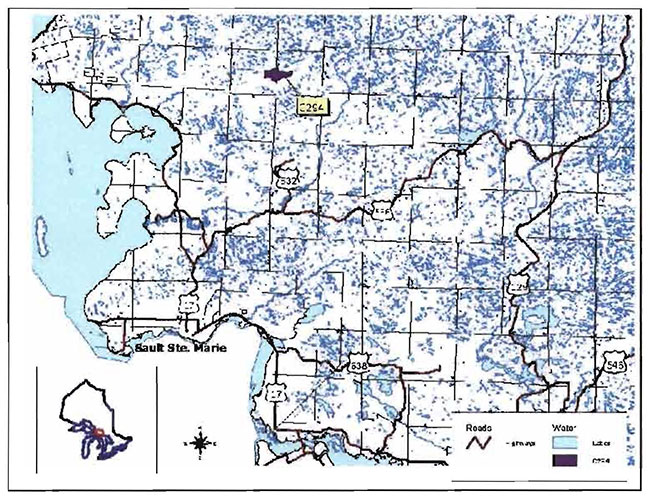
Enlarge Map la: Location of the O'Connor Conservation Reserve (C294)
Map lb: Location of the O'Connor Conservation Reserve (C294)
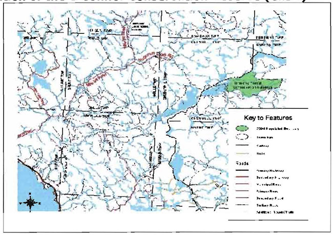
Map lc: Location of the O'Connor Conservation Reserve (C294)
Enlarge Map lc: Location of the O'Connor Conservation Reserve (C294)
Map 2: O'Connor Conservation Reserve (C294): Surficial Geology
Map 3: O'Connor Conservation Reserve (C294): Tree Species Composition Map
Map 4: O'Connor Conservation Reserve (C294): Recreation Values Map
11.0 Photos
Photo 1: Western Section. View of Sugar Maple/White Birch mixed-wood stand.
(Photo taken by Gerry Morin OMNR;Oct. 9/2002)
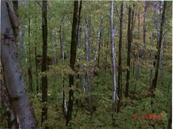
Photo 2: Western Section. View across valley of hillsides dominated by mixed hardwoods with conifer pockets of White Pine and White Spruce.
(Photo taken by Gerry Morin OMNR; Oct. 9/2002)
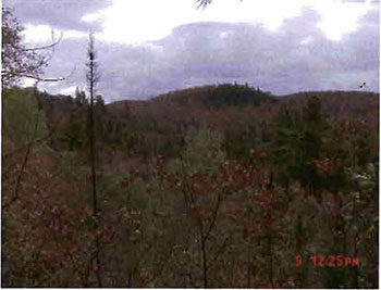
Photo 3: Southwest corner. Mature white pine growing at edge of mixed hard maple/white birch stand.
(Photo taken by Gerry Morin OMNR;Oct. 9/2002)
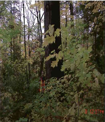
Photo 4: Southwest corner. View of a hillside ridge with varying age white pine, balsam fir understory and scattered white birch.
(Photo taken by Gerry Morin OMNR;Oct. 9/2002)
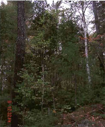
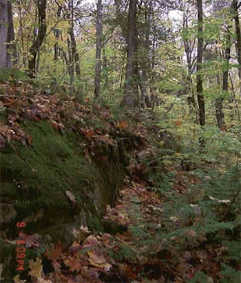
Photo 5: Central section. View of rock ridge with mature cedar and hard maple/white birch.
(Photo taken by Marjorie Hall OMNR;Oct. 9/2002)
Appendices
Appendix A: SCI Test of Compatibility
From the SCI Test of Compatibility NER Guideline in Planning process for Conservation Reserves Statement of Conservation Interest (SCI) and Resource Management Plans (RMP) Northeast Region Guidelines Version 2.1 September 17. 2001 Appendix 4, page 44.
Test of Compatibility:
- Conformity to SCI- This is not applicable to evaluating current or new uses that come forward during the SCI planning process. However, the SCI should include a statement that speaks to the required screening of any future use or uses that are not covered in the current SCI.
- Screening Process - proposed uses for the area must be assessed before they are approved. To establish a minimum standard, Northeast Region (NER) recommends that the Screening Process identified in Section 4.2 of A Class EA for Provincial Parks and Conservation Reserves Phase IIb:Draft Class EA (subject to approval by MOE) be used to screen projects and options.
The Screening Criteria from the draft Class EA (Table 4.1) are further detailed below within the context of SCI planning.
- Impact Assessment - the Test of Compatibility from the Conservation Reserve Policy (PL 3.03.05) identifies the classes of values and main concepts that need to be considered in determining the impacts of uses on a specific Conservation Reserve. These include:
- Natural heritage
- Cultural
- Research activities
- Current uses
- Area administration
- Accommodating the use outside the CR
- Socio-economics
- Area accessibility
The class EA (Table 4.1) presents similar values and concepts under the following considerations:
- Natural environment
- Land use, resource management
- Social, cultural and economic
- Aboriginal
The above considerations and classes of values are meant to assist planning staff in answering the following questions for any potential use:
- Will the new use impact any values within the Conservation Reserve?
- If so how?
- To what degree?
- Is it tolerable?
The new screening process and associated criteria identified in Table 4.1 of the draft Class EA gives planning staff more direction than the Conservation Reserve Policy 3.03.05. However this section attempts to assist planning staff by providing some direction for further interpreting the criteria to complete a Test of Compatibility for uses within a Conservation Reserve.
Appendix B: Summary of Permitted Uses
Crown Land Use Atlas - Policy report
C294
O'Connor
Updated: September 25, 2002
Identification:
ID: C294
Area Name: O'Connor
Area (ha): 895
Designation: Conservation Reserve (Ontario’s Living Legacy)
District(s): Saulte Ste. Marie
Description:
This conservation reserve, in Site District 4E-2 protects old white pine, sugar maple, yellow birch, as well as stands of black and white spruce on a landscape of steep hills interspersed with lacustrine deposits.
O'Connor was regulated as a conservation reserve on December 21, 2000.
Land Use intent:
Management of this area is also governed by the general policies contained in the Land Use Strategy (1999).
Management direction:
Those uses and management activities not listed in the following table are governed by existing conservation reserve policy. Over time the management direction will be elaborated in a Statement of Conservation Interest or Resource Management Plan. Any new uses, and commercial activities associated with conservation reserves, will be considered on a case by case basis, and they must pass a test of compatibility to be acceptable.
Compatibility is normally determined through a planning process.
Commercial activities
| Activity | Permitted | Guidelines |
|---|---|---|
| Aggregate Extraction: | No | |
| Bait Fishing Existing: | Yes | Existing use permitted to continue, unless there are significant demonstrated conflicts. |
| Bait Fishing New: | Maybe | New operations can be considered, subject to the "test of compatibility" |
| Commercial Fishing Existing: | Yes | Existing use permitted to continue, unless there are significant demonstrated conflicts. |
| Commercial Fishing New: | Maybe | New operations can be considered, subject to the "test of compatibility". |
| Commercial Fur Harvesting Harvesting Existing: |
Yes | Existing use permitted to continue, unless there are significant demonstrated conflicts. Existing trap cabins can continue; new cabins are not permitted. |
| Commercial Fur Harvesting Harvesting New: |
Maybe | New operations can be considered, subject to the "test of compatibility". |
| Commercial Hydro Development: | No | |
| Commercial Timber Harvest: | No | |
| Commercial Tourism Existing: | Yes | Existing authorized facilities can continue, unless there are significant demonstrated conflicts. |
| Commercial Tourism New: | Maybe | New tourism facilities can be considered during the planning for an individual reserve. |
| Bear Hunting by Nonresidents (guided) Existing: | Yes | Existing authorized operations permitted to continue. |
| Bear Hunting by Nonresidents (guided) New: | No | New operations not permitted. |
| Outfitting Services Existing: | Yes | Existing authorized operations permitted to continue. |
| Outfitting Services New: | Maybe | New operations can be considered during the planning for an individual reserve. |
| Outpost Camps Existing: | Yes | Existing authorized facilities permitted to continue. |
| Outpost Camps New: | Maybe | New facilities can be considered during the planning for an individual reserve. |
| Resorts/lodges Existing: | Yes | Existing authorized facilities permitted to continue. |
| Resorts/lodges New: | Maybe | New facilities can be considered during the planning for an individual reserve. |
| Energy Transmission and Communications Corridors Existing: | Yes | These facilities should avoid conservation reserve lands wherever possible. |
| Energy Transmission and Communications Corridors New: | No | |
| Food Harvesting (Commercial) Existing: | Maybe | |
| Food Harvesting (Commercial) New: | Maybe | |
| Mineral Exploration and Development: | No | |
| Peat Extraction: | No | |
| Wild Rice Harvesting Existing: | Yes | |
| Wild Rice Harvesting New: | Maybe |
Land and resource management activities
| Activity | Permitted | Guidelines |
|---|---|---|
| Crown Land Disposition Private Use: | Maybe | Sale of lands is not permitted, except for minor dispositions in support of existing uses (e.g. reconstruction of a septic system). Renewals of existing leases and land use permits are permitted. Requests for transfer of tenure will be considered in the context of the Statement of Conservation Interest or Resource Management Plan. |
| Crown Land Disposition Commercial Use: | Maybe | New leases or land use permits permitted for approved activities. Tourism facilities can apply to upgrade tenure from LUP to lease. |
| Fire Suppression: | Yes | Fire suppression policies are similar to adjacent Crown lands, unless alternative fire policies have been developed through a planning process. |
| Fish Habitat Management: | Maybe | |
| Fish Stocking: | Maybe | Existing authorized operations permitted to continue. New operations not permitted. |
| Inventory/disease Supperssion: | Maybe | |
| Inventory/Monitoring: | Yes | |
| Prescribed Burning: | Maybe | |
| Roads (Resource Access) Existing: | Yes | Existing roads can continue to be used. Continued use will include maintenance and may include future upgrading. |
| Roads (Resource Access) New: | Maybe | New roads for resource extraction will not be permitted, with the exception of necessary access to existing forest reserves for mineral exploration and development. |
| Vegetation Management: | Maybe | Conservation Reserves policy indicates that Featured Species Management and Natural Systems Management may be permitted. Vegetation management can be considered in a planning process. |
| Wildlife Population Management: | Maybe |
Science, education and heritage appreciation
| Activity | Permitted | Guidelines |
|---|---|---|
| Collecting: | No | |
| Historical Appreciation: | Yes | |
| Nature Appreciation: | Yes | |
| Photography and Painting: | Yes | |
| Research: | Yes | |
| Wildlife Viewing: | Yes |
Recreation activities and facilities
| Activity | Permitted | Guidelines |
|---|---|---|
| All Terrain Vehicle Use On Trails: | Yes | Existing use permitted to continue where it does not adversely affect the values being protected. ATV use off trails is not permitted except for direct retrieval of game. |
| All Terrain Vehicle Use Off Trails: | No | |
| Campgrounds: | Maybe | |
| Food Gathering: | Yes | |
| Horseback Riding (trail): | Yes | Existing use on trails permitted. |
| Hunting: | Yes | |
| Mountain Bike Use: | Yes | Existing use on trails permitted. |
| Motor Boat Use Commercial: | Yes | |
| Motor Boat Use Private: | Yes | |
| Non-motorized Recreation Travel: | Yes | |
| Private Recreation Camps (Hunt Camps) Existing: | Yes | |
| Private Recreation Camps (Hunt Camps) New: | No | Existing camps permitted to continue, and may be eligible for enhanced tenure, but not purchase of land. |
| Rock Climbing: | Maybe | |
| Snowmobiling On Trails: | Yes | Existing use permitted to continue where it does not adversely affect the values being protected. |
| Snowmobiling Off Trails: | Maybe | Snowmobile use off trails is not permitted, except that snowmobiles may be used for direct retrieval of game. |
| Sport Fishing: | Yes | |
| Sport Fishing Trail Development New: | Maybe | Development of trails for a variety of activities (e.g. hiking, cross-country skiing, cycling, horseback riding, snowmobiling) can be considered as part of planning for an Individual reserve. |
Note: The poilcies outlined in this table do not supersede any Aboriginal or treaty rights tnat may exist, or other legal obligations.
Management of this conservation reserve is carried out within the context of Conservation Reserve policy as amended by the policies for new conservation reserve outlined in the Ontario’s Living Legacy Land Use Strategy.
Source of direction:
Ontario’s Living Legacy Land Use Strategy (1999)
Conservation Reserves Policy (1997)
Explanation of edits:
Appendix C: Public consultation handouts
64 Church Street
Sault ste. Marie, ON P6A 3H3
Telephone: 705-949-1231 ext. 210
Facsimile: 705-949-6450
Email: serge.tenaglia@mnr.gov.on.ca
November 10, 1999
To: Ontario Living Legacy stakeholders
Dear Sir/Madam:
On July 16, 1999, the Ontario Government released Ontario’s Living Legacy Land Use strategy, a broad land use strategy for the planning and management of much of the Crown lands in central and parts of northern Ontario. A major part of Ontario’s Living Legacy Use Strategy was a government commitment to the biggest expansion of provincial parks and conservation reserves in Ontario’s history. Ontario intends to add 378 new areas to its protected areas' system. Ontario’s Living Legacy is a momentous achievement that will be recognized around the world as a significant contribution to sustaining our natural environment. A copy of the Land Use Strategy is available from our office upon request.
In accordance with the recommendations in Ontario’s Living Legacy Land Use strategy, the Ministry of Natural Resources is now beginning the process of establishing the first set of 64 protected areas from the Land Use Strategy. The first step in this process is consultation on the boundaries of these 64 areas. the remaining 314 proposed protected areas will be consulted upon in the future.
A stated in the Land Use Strategy, the boundary refinement process will consider local ecological information and will attempt to locate regulated boundaries along features that can identified on the ground. This boundary refinement process may result in modest increases or decreases in the sizes of the areas. Any existing commitments for the areas which were considered during the land use planning process, will be considered in defining the final boundary.
This list of 64 areas includes the proposed Wabos North, Wabos South, Jollineau, La Verendry/Ogidaki. Garden River Forest, Tilley Creek West, O'Connor and Harmony Conservation reserves.
The Land Use Strategy established the Ministry’s intent to add these Crown lands to Ontario’s protected areas' system, following the extensive public consultation associated with Ontario’s Living Legacy and the Land for Life land use planning initiatived between 1997 and 1999. Prior to the finalization of the boundary of these conservation reserves proposed for regulation under the Public Lands Act, the Ministry is inviting public comment on the proposal boundaries.
Your name and address have been included within a Ministry mailing list to advise potentially interested persons about these new conservation reserves. This mailing list includes a broad group such as nearby landowners, resource users, persons with other rights or tenure (e.g. land use permit, Mining Act rights), municipalities and others who may have an interest in these areas.
Information describing these proposed areas is attached. More detailed mapping and information about the proposed boundaries are available from this office.
In the future and subject to the intended regulation of these areas as conservation reserves, the Ministry of Natural Resources will undertake a management planning process to determine the long-term management of these protected areas. Depending upon the complexity of issues related to these conservation reserve, management planning may take the form of a simple Statement of Conservation Interest or a more detailed Resource Management Plan. Please let us know if you would like to be notified when planning begins.
Planning, management and permitted uses within these conservation reserves would be consistent with the commitments of Ontario’s Living Legacy Land Use Strategy.
The Ministry is collecting comments and information regarding these proposed conservation reserve boundary reviews under the authority of the Public Lands Act, to assist in making decisions and determining further public consultation needs. Comments and opinions will be kept on file and may be included in study documentation that is made available for public review. Under the Freedom of Information and Protection of Privacy Act (1987),personal information will remain confidential unless prior consent is obtained. However, the Ministry may use this information as public input on other resource management surveys or projects. For further information regarding this Act, please contact Wayne Fiset, Information Management Supervisor, Ministry of Natural Resources, Sault Ste. Marie District (705-949-121 ext. 288)
If you would like to discuss the proposed boundaries and the protection of these areas under the Public Lands Act, please contact Erin Nixon, community Planner, Ministry of Natural Resources, 64 Church St., Sault Ste. Marie, P6A 3H3, tel: 705-949-121, fax: 705-949-6450, by December 15, 1999. Further information on Ontario’s Living Legacy is available in our office or by visiting the Ministry’s Internet website at www.mnr.gov.on.ca/MNR/oll/.
Thank you for your interest.
Yours sincerely,
Signed by:
Serge Tenaglia
District Manager
O'Connor Conservation Reserve (C294) Fact Sheet
January, 2001
Background
On July 16, 1999, the Ontario Government released Ontario’s Living Legacy Land Use Strategy to guide the planning and management of Crown lands in central and parts of northern Ontario. A major part of Ontario’s Living Legacy Land Use Strategy was a government intent to establish 378 new protected areas. This commitment marks the biggest expansion of provincial parks and conservation reserves in Ontario’s history.
The O'Connor Conservation Reserve is part of this significant expansion of Ontario’s protected areas system. Following public and aboriginal consultation in late 1999 and early 2000 on refining the boundary of this protected area, Ontario Regulation 805/94 of the Public Lands Act was amended on January 6, 2001, by Ontario Regulation 686/00, to formally establish this conservation reserve.
Size and location
The O'Connor Conservation Reserve is located approximately 60 km north of the City of Sault Ste. Marie in the vicinity of Batchawana Bay. Situated in the Townships of Dablon and Grenoble, the reserve is 895 ha in size.
Area highlights
The O'Connor Conservation Reserve is located in a scenic area of Ontario along the Lake Superior coastline between Agawa Bay and Gros Cap. Known by resource managers as "ecological site district 4E-2", this ecological unit extends inland for approximately 60-90 km. The topography tends to be rugged, with elevations exceeding 450 metres, and is the result of numerous geological structures such as faults, joints, and diabase dikes that disect the area. The bedrock uplands have a thin layer of sandy soil on the upper slopes and thicker soils in the valleys. Exposed bedrock is common, and dates back billions of years to the Precambrian and Cambrian periods. Pockets of "lacustrine deposits", soils that were formed long ago in a lake, are also found in the area.
Located within the Algoma Forest Section of the Great Lakes-St. Lawrence Forest Region, the O'Connor Conservation Reserve is characterized by a high proportion of tolerant hardwood trees. Old stands of sugar maple, red maple, yellow birch, white pine, balsam fir, white spruce, and white birch are found throughout the area, as well as younger stands of yellow birch, sugar maple and red maple. The area is segmented by numerous tributaries feeding into the Chippewa River system, including the east branch of the Chippewa River and O'Connor Creek.
While a detailed biological study has not been conducted within the conservation reserve, a number of significant species are known to be present within site district 4E-2. The provincially significant wood turtle has been recorded here, while the increasingly rare snapping turtle reaches the northern limits of its range. The endangered bald eagle breeds here as well as the provincially significant least bittern, red-shouldered hawk, American coot, and long-eared and short-eared owls. Many rare vascular plants have been recorded, including Braun’s holly fern, the limestone oak fern, the lance-leaved coreopsis, and the monkey flower.
Land Use Intent
Conservation reserves are areas of Crown land set aside by regulation under the Public Lands Act.
Conservation reserves complement provincial parks in protecting representative natural areas and special landscapes. Most recreational activities (e.g. hiking, skiing, tourism related uses, nature appreciation) and non-industrial activities (e.g. fur harvesting, commercial fishing and bait harvesting) that have traditionally been enjoyed in the area will continue, provided that these uses do not impact on the natural features needing protection. Hunting and fishing are also permitted within all new conservation reserves proposed through Ontario’s Living Legacy.
Commercial timber harvesting, mining, aggregate extraction and commercial hydroelectric development are prohibited in conservation reserves. Careful mineral exploration may occur in specific new conservation reserves proposed through Ontario’s Living Legacy, in areas that have provincially significant mineral potential. If a portion of a new conservation reserve is to be developed for a mine, it would be removed from the reserve, and appropriate replacement lands would be placed into regulation. Please refer to Table 4 from the Land Use Strategy for a detailed summary of permitted uses in conservation reserves.
Next steps
This regulated area has been withdrawn and protected from resource extraction activities such as timber harvesting, hydroelectric development, aggregate extraction and new mineral exploration.
In the future, the Ministry of Natural Resources will prepare a longterm management plan for this area. Depending upon the complexity of issues within this conservation reserve, management planning may take the form of a simple Statement of Conservation Interest or a more detailed Resource Management Plan. Please let us know if you would like to be notified when planning begins.
Planning, management and the uses permitted within this conservation reserve would be consistent with the commitments of Ontario’s Living Legacy Land Use Strategy.
For more information
For further information on the O'Connor Conservation Reserve, please contact Erin Nixon, District Planner, Ministry of Natural Resources, Sault Ste. Marie District (705-949-1231 ext. 247). You may also visit the Ministry’s Internet website at www.ontarioslivinglegacy.com (link no longer active) for information on Ontario’s Living Legacy.
64 Church Street
Sault Ste. Marie, ON P6A 3H3
August 22, 2001
Regulation of Ontario’s Living Legacy protected areas in Sault Ste. Marie district
In July 1999, the Ontario Government released the Ontario’s Living Legacy Land Use Strategy, a broad land use approach to the planning and management of Crown lands in central and parts of northern Ontario. A large component of the Ontario’s Living Legacy Land Use Strategy was a government commitment to add 378 new provincial parks and conservation reserves to Ontario’s protected areas system.
In November 1999 and again in September 2000, we provided you with the opportunity to comment on the proposed boundaries for the park and the conservation reserves in Sault Ste. Marie District. Iam pleased to inform you that, as of January 2001, the park and fifteen of these conservation reserves have been regulated. The new park and conservation reserves in the District are:
- P285 Sandy Islands Provincial Nature Reserve
- C243 Wagong Lake Forest Conservation Reserve
- C244 Rawhide Lake Conservation Reserve
- C245 Jollineau Conservation Reserve Conservation Reserve
- C246 Echo River Hardwoods Conservation Reserve
- C258 Thessalon River Delta/Rock Lake Red Oak Conservation Reserve
- C260 Rose Lake Dune Peat/and Complex Conservation Reserve
- C262 Stuart Lake Wetland Conservation Reserve
- C263 Garden Lake Forest Conservation Reserve
- C281 Tilley Creek West Conservation Reserve
- C284 Wabos North Conservation Reserve
- C286 Wabos South Conservation Reserve
- C289 Searchmont South Forest Conservation Reserve
- C294 O'Connor Conservation Reserve
- C298 Harmony Forest Conservation Reserve
- C307 lie Parisienne Conservation Reserve
Regulation means the park and conservation reserves are now legally mapped and recognized as protected areas of crown land under the jurisdiction of the provincial government. As such, these areas will be protected from industrial activities, including commercial forestry, hydroelectric development, mining, and aggregate and peat extraction. Traditional recreational and resource uses such as hunting, fishing, hiking, canoeing, boating, and fur trapping, will generally be permitted to continue within the Wabos South Conservation Reserve Statement of Conservation Interest conservation reserves. In nature reserve class provincial parks (eg. P285, Sandy Islands), hunting and fur trapping are not permitted; other traditional recreational uses (fishing, hiking, canoeing, boating) may continue.
Ontario Parks staff is responsible for the planning and management of Sandy Islands Provincial Nature Reserve and they will prepare an Interim Management Statement to guide the management of this property. Sault Ste. Marie District is responsible for the management of the conservation reserves and will develop Statements of Conservation Interest (SCI) to guide the management of each new conservation reserve. There will be opportunity for the public to review and comment on draft SCI for each conservation reserve. Depending upon the complexity of issues related to the sites and their management, more detailed Management Plans may, in due course, be required.
Detailed maps of the regulated boundaries for these new protected areas are available for viewing in the Sault Ste. Marie District office and the Blind River Area office of the Ministry of Natural Resources.
If you have any questions or concerns about the management of Sandy Islands Provincial Nature Reserve, please contact Chris Caldwell, Ontario Parks at the Sault Ste. Marie District Office. Concerns regarding any of the conservation reserves, should be addressed to Sheila Walsh (OLL Resource Planner) also at the Sault Ste. Marie District Office.
Thank you for your interest in Ontario’s Living Legacy.
Yours truly,
Tom Mispel-Beyer
A/District Manager
Sault Ste. Marie District
Telephone: 705-949-1231
Facsimilie: 705-949-6450
E-mail: tom.mispelbeyer@mnr.gov.on.ca
Footnotes
- footnote[1] Back to paragraph This Test of Compatibly is taken from both Procedural Guidelines B-Land Uses -Test of Compatibility PL 3.03.05 and from the Planning Process for Conservation Reserve Statement of Conservation Interest and Resource Management Plan Northeast Region Guidelines Version 2.1 September 17, 2001.