Octopus Creek Conservation Reserve Management Statement
This document provides policy direction for the protection, development and management of the Octopus Creek Conservation Reserve and its resources.
Statement of Conservation Interest (C2373)
OMNR, Kenora District
June, 2003
Prepared by: Catherine Reaburn, OLL Intern
Prepared for: OMNR, Kenora District
Date: February, 2002
Approval statement
We are pleased to approve this Statement of Conservation Interest for the Octopus Creek Conservation Reserve.
This Statement of Conservation Interest provides guidance for the management of the conservation reserve and the basis for the ongoing monitoring activities. More detailed direction at this time is not anticipated. Should significant facility development be considered or complex issues arise requiring additional studies, more defined management direction, or special protection measures, a more detailed Conservation Reserve Management Plan will be prepared with full public consultation.
The public was widely consulted during the original regulation process and further consultation is not required at this time.
The conservation reserve will be managed under the jurisdiction of the Kenora West Area Supervisor, Kenora District, Ministry of Natural Resources.
Fred S. Hall
District Manager
Kenora District
Charlie Lauer
Regional Director
Northwest Region
1.0 Background information
During the Lands for Life process, areas representative of Ontario’s diverse ecosystems and biological/geological features were identified and recommended for regulation as parks and conservation reserves under the Provincial Parks Act and the Public Lands Act (OMNR, 1999). Ontario’s Living Legacy expanded the percentage of Ontario’s protected areas to encompass twelve percent of the province’s land and water base. Octopus Creek Conservation Reserve is one of the representative areas selected for protection in site region/district 4S-1, and was regulated June 7, 2003 (Reg. 208/03). The area was selected as a candidate under Ontario’s Living Legacy due to the fact that this site contains representative landform and vegetation types, including bedrock and strongly broken bedrock with conifer, deciduous and mixed forests (OMNR, 1999).
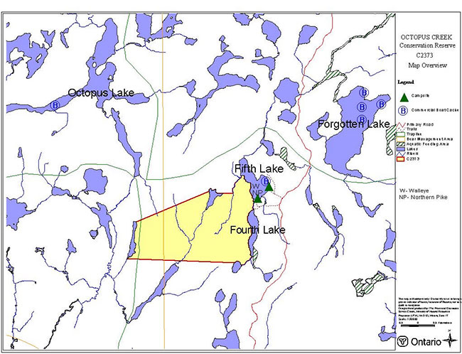
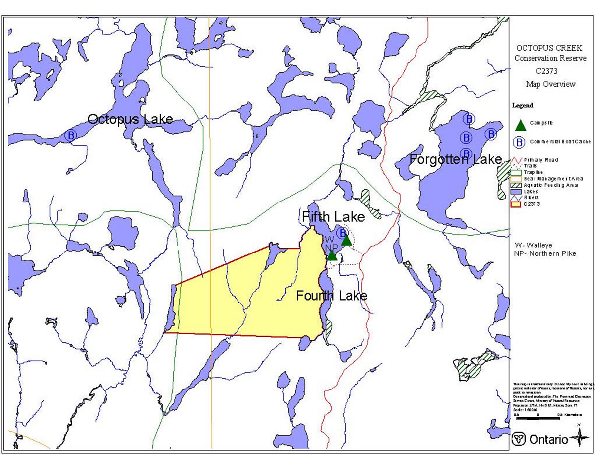
Octopus Creek Conservation Reserve is located approximately 28 kilometres north of the City of Kenora and approximately 7 kilometres north of the hamlet of Redditt. This conservation reserve incorporates one small, unnamed lake within its boundary. The shorelines of several small lakes form the site’s west, north, and east boundaries. The total area to be regulated is approximately 613 hectares (OMNR, 2001a).
The intent of this Statement of Conservation Interest is to identify the natural heritage values of Octopus Creek Conservation Reserve, the activities occurring in the area and, through a set of management guidelines, outline the activities that will be permitted and prohibited.
For more information regarding the basis of this Statement, please refer to the "Conservation Reserve Policy and Procedure PL3.03.05", specifically, pages 2-6 and 14-22 of the procedure (OMNR, 1997a).
| Name | Octopus Creek Conservation Reserve (C2373) |
|---|---|
| Site Region/Site District | 4S-1 |
| OMNR Administrative Region/District/Area |
Northwest/Kenora/Kenora West |
| Total Area (ha) | 613 ha |
| Regulation Date | Anticipated in 2003 |
| First Nations with Interest in Area | There are several Treaty 3 First Nations in the area that may have an interest in the Octopus Creek area. |
| OBM | 2015390055400, 2015400055400 |
| Latitude/Longitude | 50º 2' N/ 94º 25' W |
| Basemap | 39554, 40554 |
| FRI Stand Numbers (located partially and fully within Octopus Creek Conservation Reserve) | 8647, 9646, 8444, 7642, 9039, 7341, 7642, 8338, 7840, 8135, 7336, 7240, 7040, 6939, 6739, 8337, 9540, 7932, 6636, 7728, 6929, 6428, 8528, 8727, 8632, 9065, 8835, 8832, 9130, 9226, 9327 |
| General Location Description | This site is located approximately 28 kilometres north of the City of Kenora and 7 kilometres north of the hamlet of Redditt. |
| Access | The reserve is accessible by foot, water, and air. |
1.1 Representation targets
This section provides a summary of the earth/life science values, cultural resources, and the recreational opportunities available or possible within Octopus Creek Conservation Reserve.
| Life Science Representation | Jack pine and black spruce are typically the most abundant tree species, and trembling aspen and white birch are also extensively present. Green alder, Bebb’s willow, serviceberries, and bush honeysuckle are the dominant shrubs (Foster & Harris, 2002). |
|---|---|
| Earth Science Representation | Octopus Creek Conservation Reserve lies within the Winnipeg River Subprovince Typically the rock is a foliated pink to grey, medium grained biotite granodiorite (Blackburn, 2002). |
| Cultural Resource Representation | Nothing known at this time. |
| Recreational Opportunities | Camping, fishing and hunting are the main recreational activities. |
1.2 Survey information
This section provides an overview of the inventories that were completed, their level of detail, and any further inventories that are necessary.
| Survey Level | Reconnaissance | Detailed |
|---|---|---|
| Life Science | Checklist and summary report completed by Northern Bioscience. Survey conducted by helicopter on June 13th, 2001. | Not required. |
|
Earth Science |
Checklist and summary report completed by Charles Blackburn. Survey conducted by helicopter on June 13th, 2001. | Not required. |
| Cultural | Not required. | Not required. |
| Recreational | Recreational assessment, Kenora staff; 2001. | Not required. |
| Other | Not required. | Not required. |
2.0 Values to be protected
This section provides a description of the key natural heritage values on the site, their condition relative to past resource use and management activities, as well as their sensitivity to future land use and management activities.
2.1 Life sciences
Representative landforms and vegetation types, including bedrock and strongly broken bedrock with conifer, deciduous, and mixed forests were expected to be found in the Octopus Creek Conservation Reserve (OMNR, 1999). The life science surveys identified the following life science values.
Jack pine and black spruce are typically the most abundant tree species, but trembling aspen and white birch may be present and even dominant in some stands. Green alder, Bebb’s willow, serviceberries and bush honeysuckle are the dominant shrubs (Foster et al, 2002).
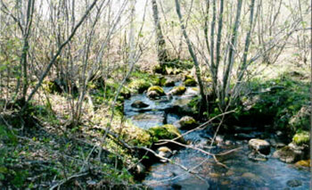
Wetlands in the reserve occur on organic deposits along valley bottoms and adjacent to lakeshores. Alder thicket swamps and bluejoint grass-dominated meadow marshes are strongly influenced by beaver activity on the several small streams that run north-south through the reserve (Foster et al, 2002).
Figure 1: Wetland area in the western portion of the reserve
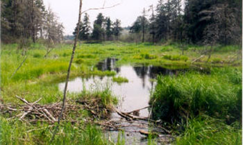
Figure 2: Creek running north-south between Fourth and Fifth Lake
2.2 Earth sciences
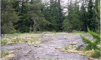
Based on initial, coarse-level data, Octopus Creek Conservation Reserve was reported to contain both moderately and strongly broken bedrock landform types. However, during the earth and life science reconnaissance field studies it was determined that most of the reserve contains moderately broken bedrock and that any representation of strongly broken bedrock within the reserve was questionable (Foster et al, 2002).
Although Octopus Creek Conservation Reserve is said to be situated within the Lount Lake batholith, none of the rock within the reserve was found to be representative of this batholith. Typically the rock is a foliated pink to grey, medium grained biotite granodiorite whereas rock within the Lount Lake batholith is massive porphorytic rock that varies in colour from shades of pink to grey to yellow to green (Blackburn, 2002). A more detailed earth science inventory would be necessary to determine whether this conservation reserve does indeed lie within the Lount Lake batholith.
Pleistocene surficial deposits are rare in the reserve and are confined to shallow till ground moraine over bedrock. Very large perched boulders dot the landscape and are probably remnants of boulder beaches washed by glacial Lake Agassiz (Blackburn, 2002).
2.3 Tourism
There are no tourist establishments immediately within the conservation reserve, however, the reserve is part of two Bear Management Areas that are operated by tourist camps in the area.
2.4 Aboriginal values
At this time, there are no known aboriginal values within the Octopus Creek Conservation Reserve (OMNR, 1995).
Figure 3: Exposed bedrock in the western portion of the reserve
2.5 Fishing
The primary game fish within and around the Octopus Creek Conservation Reserve are walleye and northern pike.
2.6 Cultural/historical values
At this time there are no known cultural or historical values within the Octopus Creek Conservation Reserve (OMNR, 1995).
2.7 Hunting
Octopus Creek Conservation Reserve is part of Wildlife Management Unit # 6 and includes moose, deer, and black bear, as well as other small game animals and a variety of waterfowl. The reserve is part of two Bear Management Areas.
2.8 Recreational values
Camping, fishing, and hunting, are the most popular recreational activities within the Octopus Creek Conservation Reserve. The lakes within and around the Octopus Creek Conservation Reserve are most likely accessed by small boat and canoe. Fishing opportunities exist for northern pike and walleye. There is one established campsite within the reserve and one established camp site outside of the reserve boundaries on the northeast shore of Fifth Lake.
2.9 Mining
The mineral potential in the Octopus Creek Conservation Reserve is undetermined at this time. No new mineral exploration may occur in the conservation reserves proposed through Ontario’s Living Legacy – Land Use Strategy. No mineral exploration and extraction may occur within the Octopus Creek Conservation Reserve (OMNR, 1997a).
2.10 Aggregates
There is no aggregate development within the Octopus Creek Conservation Reserve (Moorley, 2002).
2.11 Forest harvesting
The forest values within the reserve boundaries are to be protected from any unnatural alteration (OMNR, 1999; 1997a). Successional changes associated with each forest type occurring in the area (depending on each stand’s stage of maturity, specific vegetative species composition, and soil type) are anticipated to take place as outlined in the following statements. Please note that for the purpose of this document, the successional time frame is depicted as 100 years.
The most significant natural disturbance in the Octopus Creek Conservation Reserve is wildfire. A large fire burned most of the reserve in 1929 and another smaller fire burned the western portion of the reserve again in 1939. Today there is no representation of these burns and some areas which are actually conifer on bedrock are misclassified as burn (Foster et al, 2002). There was moderate damage caused by spruce budworm in 1991 and 1993 within the reserve and high budworm-induced mortality in the extreme northeast corner of the reserve in the mid-1990's. Severe defoliation of the trembling aspen, fireweed, and blueberries by forest tent caterpillars was observed during field reconnaissance in 2001 (Foster et al, 2002).
In the valley bottoms there is evidence of a significant amount of beaver activity, particularly adjacent to aspen stands. As a result, the changes in hydrology caused by beaver dams has resulted in the formation of alder thicket swamps and meadow marshes along some of these systems (Foster et al, 2002).
Jack pine and black spruce are typically the most abundant tree species within the Octopus Creek Conservation Reserve but significant amounts of white birch and trembling aspen may also be present (Foster et al, 2002). The longterm succession for these areas is towards a more open canopy black spruce –feathermoss condition although the rate at which this happens varies considerably from site to site. Total canopy tree cover will decline through time as will tall and low shrub cover. Jack pine may regenerate in the understory due to gaps in the canopy. Remnant jack pine and white birch may also occur in older stands that are dominated by black spruce (OMNR, 1997b).
2.12 Trapping
The reserve is part of one registered trapline.
2.13 Wildlife
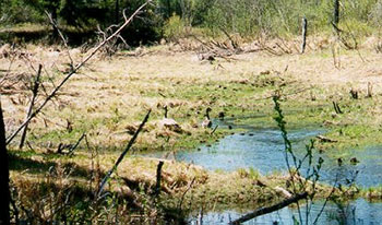
A large amount of wildlife can be found within the reserve including moose, whitetail deer, black bear, waterfowl, and a variety of small game animals. There is a moose aquatic feeding area on the southern end of Fourth Lake at the edge of the reserve (Foster et al, 2002).
Figure 4: Canada geese pair in a marshy area between Fourth and Fifth Lake
2.14 Commercial fishing
The Octopus Creek Conservation Reserve is part of one registered baitfish area.
3.0 Management guidelines
3.1 Land Tenure
The Octopus Creek Conservation Reserve consists entirely of Crown land. Disposition of land through Crown Lease or Land Use Permit may be permitted within the conservation reserve for approved activities and provided there are no impacts on identified values (OMNR, 1997a). No disposition of land by sale will be permitted.
3.2 Existing and proposed development
There is no existing or proposed development within the Octopus Creek Conservation Reserve and because of this, the reserve is in relatively undisturbed condition (Foster et al, 2002). The Fifth Creek Jack Pine Seedling Seed Orchard is situated close to the reserve on the north shore of Fifth Lake.
3.3 Recreational activities
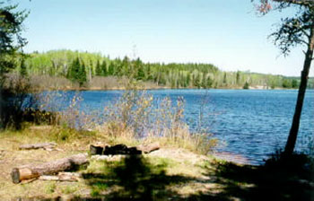
Camping is probably the most popular activity within the Octopus Creek Conservation Reserve. One well-used campsite is located near the reserve on the south shore of Fifth Lake. Another well-used campsite that is accessible by a 4 x 4 vehicle is located on the north-east shore of Fifth Lake near the reserve. On the day of the inventory there was evidence that both of these sites had been used fairly recently. Hunting and fishing are probably also popular recreational activities in the area due to the ease of accessibility of Fifth Lake. It is possible to launch a small boat or canoe from the campsite on the north-east shore.
Figure 5. Campsite on the northeast shore of Fifth Lake
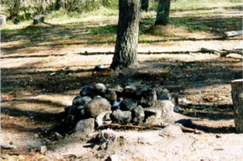
Figure 6 : Campsite on the south shore of Fifth Lake
3.4 Commercial activities
Trapping will continue to be permitted within the reserve boundary as the area forms part of one registered trapline (OMNR, 1999). Black bear hunting will also continue to be permitted since the reserve is part of two Bear Management Areas. The reserve is also part of one registered baitfish operation. No changes to these areas are required at this time provided that they do not impact the reserve’s identified and protected natural heritage values. No further commercial activities will be permitted in the area, including road construction and removal of aggregates (OMNR, 1999; 1997a). The development of utility corridors is discouraged.
The area will be removed from the operable Kenora Forest Land Base and the Sustainable Forest License. The area has been withdrawn from all mining exploration and extraction activities by the Ministry of Northern Development and Mines (MNDM).
3.5 Aboriginal Interests
Octopus Creek Conservation Reserve is located within a primary interest area of several First Nations. Any specific aboriginal values associated with the reserve are unknown at this time. Nothing in this Statement of Conservation Interest will affect existing or future aboriginal or treaty rights.
3.6 Natural Resources Stewardship
3.6.1 Vegetation management
The MNR recognizes fire as an essential process fundamental to the ecological integrity of conservation reserves. In accordance with existing Conservation Reserve Policy and the Forest Fire Management Strategy for Ontario, forest fire protection will be carried out as on surrounding lands.
Whenever feasible, the MNR fire program will endeavour to use "light on the land" techniques, which do not unduly disturb the landscape, in this Conservation Reserve. Examples of light on the land techniques may include limiting the use of heavy equipment or limiting the number of trees felled during fire response efforts.
Opportunities for prescribed burning to achieve ecological or resource management objectives may be considered. These management objectives will be developed with public consultation prior to any prescribed burning, and reflected in the document that provides management direction for this conservation reserve. Plans for any prescribed burning will be developed in accordance with the MNR Prescribed Burn Planning Manual, and the Class Environmental Assessment for Provincial Parks and Conservation Reserves (approval pending).
Fuelwood permits will not be issued within the area encompassed by the Octopus Creek Conservation Reserve. However, usage of the areas wood resource for shorelunches and campfires will be permitted provided that there is no resulting damage or alteration of the forest and its understory (OMNR, 1997a).
3.6.2 Fish and wildlife management
No management action is required other than the implementation of existing Wildlife Management Unit #6 regulations and Division #22 sport fishing regulations and management activities.
3.6.3 Landforms
The landforms represented within Octopus Creek Conservation Reserve will not be altered through any landform modification activities, including filling and extraction of aggregates, peat, soils, and similar materials (OMNR, 1997a).
3.7 Cultural Resources Stewardship
Based on existing information, there are no requirements at this time.
3.8 Client services
Information regarding this conservation reserve will be made available so as to ensure that all resource users (particularly forestry and mining companies) are aware of its location, recognized values, and permitted uses. Potential users include tourists, local anglers/hunters, recreationalists (ie. canoeists, hikers, snowmobilers), and the general public, all of who may utilize the areas wood resource for camping, shorelunches, firewood, and personal use.
3.9 Research
Non-destructive research relating to cultural and historical values within the reserve would be beneficial so as to add further potential values to the reserve, as well as to ensure their protection.
3.10 Marketing
There are no marketing requirements at this time.
4.0 Implementation
These management guidelines will be implemented immediately by the Kenora District of the MNR. Any MNR Resource Management Plans or Land Use Plans which include this area will be amended accordingly. Any affected clients will be immediately informed of the changes, should any arise. Administrative responsibility for the conservation reserve rests with the Kenora West Area Supervisor. Implementation will primarily involve monitoring activities to ensure adherence to the management guidelines.
5.0 Review and revisions
5.1 Review and revisions
Minor amendments to this Statement of Conservation Interest may require to be posted on the Environmental Bill of Rights (EBR) Registry prior to their approval. Consultation efforts may also be required, as determined by the Area Supervisor, as well as the approval of the District Manager and the Regional Director.
5.2 Public consultation
5.2.1 Results of past consultation
Contact regarding the regulation of Octopus Creek Conservation Reserve was made with timber companies, local communities, and the general public in June, 2001. Consultation efforts involved the direct mailing of a District information package to local interest groups (such as the Local Citizens Committee), as well as to all those with patent land, boat caches, bear management areas, trapline areas, bait fishing areas, and Sustainable Forest Licenses within and/or adjacent to the reserve’s proposed boundaries. Newspaper advertisements were issued in the Kenora Enterprise and the Kenora Daily Miner and News in mid-June, 2001. Only a few responses were received and were specifically related to activities permitted and prohibited within the proposed conservation reserves in the Kenora District.
First Nation consultation associated with the Octopus Creek Conservation Reserve has been completed. The Grand Council Treaty #3 office had hired an individual to assist both MNR and the area First Nations to complete these consultations. No First Nation values were identified during this consultation effort.
5.2.2 Present and future consultation
More widespread consultation is not deemed necessary at this time due to the extensive consultation which took place in June, 2001 (refer to section 5.2.1).
6.0 References
Blackburn, Charles. 2002. Detailed Information For Site 2373: Octopus Creek.
Foster, Robert & Harris Allan. 2002. Life Science Checksheet. C2373 Octopus Creek.
Moorley, Rob. 2002. Resource Management Technician. Personal Correspondence. OMNR, Kenora District.
Ontario Ministry of Natural Resources. 2001a. Ontario’s Living Legacy Fact Sheet - Octopus Creek Conservation Reserve (C2373).
Ontario Ministry of Natural Resources. 2000b. Kenora District-Kenora & Whiskeyjack Forests Wildfire/Blowdown History Map (200 + Ha).
Ontario Ministry of Natural Resources. 1999. Ontario’s Living Legacy Land Use Strategy.
Ontario Ministry of Natural Resources. 1997a. Conservation Reserves Policy and Procedure. PL 3.03.05.
Ontario Ministry of Natural Resources. 1997b. Silvicultural Guide to Managing for Black Spruce, Jack Pine and Aspen on Boreal Forest Ecosites in Ontario. Book II: Ecological and Management Interpretation for Northwest Ecosites. Version 1.1 September, 1997.
Ontario Ministry of Natural Resources. 1995. Kenora District Archaeological Sites – Map 52L/1.
Appendix A: Map of SCI sites within Kenora District- 2001/2002
Appendix B: Map of values within Octopus Creek Conservation Reserve
Enlarge Appendix B: Map of values within Octopus Creek Conservation Reserve
Appendix C: Life Science Checksheet
C2375 Octopus Creek
Natural Heritage Area – Life Science Checksheet
| Name: | Octopus Creek |
|---|---|
| Map Name: | |
| Map Number: | 52L/1 |
| UTM Ref.: | Zone 15 398000 E 5544000 N |
| County: | Kenora |
| Latitude: | 50° 2' N |
| Longitude: | 94° 25' W |
| NAD: | 83 |
| Minimum Altitude: | 430 m |
| Maximum Altitude: | 360 m |
| Locality: | Approx. 30 N of Kenora |
| Township: | unorganized |
| Area: | 603 ha |
| Ownership: | Crown |
| MNR Region: | Northwest |
| Ecoregion and Ecodistrict: | 4S-1 |
| Landform Unit: | See Table 3 |
| MNR District: | Kenora |
| Aerial Photographs: Year – Roll – Flight Line – Numbers |
95-5001 32-182, 95-5001 32-183 95-5002 32-109 to 95-5002 32-111, |
Physical and biological features
Octopus Creek Conservation Reserve encompasses approximately 600 ha of bedrock-controlled terrain 3 km southeast of Octopus Lake. Two small lakes (<50 ha) form much of the reserve’s eastern boundary, and a third unnamed lake borders the reserve on the west. The waters of another small (10 ha), unnamed lake on the northern boundary are entirely within the reserve.
Rock barren (Ecosite 7) is widespread in the reserve, particularly in the western half, on exposed bedrock hilltops with little or no soil. These xeric communities have scattered, stunted jack pine and pin cherry, with three-toothed cinquefoil, sandcherry, and harebell in association with extensive reindeer lichen (Cladina mitis, C. rangerferina, C. stellaris). These communities are often classed as bedrock outcrop (4 ha) or sparse forest (285 ha) by Lancover28 or as the vegetated bedrock LV-type (168 ha).
Ecosite 12 is the predominant forested ecosite in the reserve. Jack pine and black spruce are typically the most abundant tree species, but trembling aspen and white birch may be present and even dominant. They are typically found on very dry and very shallow sandy soils on hill tops and upper slopes. Green alder, Bebb’s willow, serviceberries (Amelanchier spp.) and bush honeysuckle the dominant shrubs. Large-leaved aster, Canada mayflower, and bunchberry are found in patches on extensive feathermoss groundcover (e.g. Schreber’s moss). Much of Ecosite 12 (and some of ES7) is classed as sparse (~30-40% canopy cover) deciduous and conifer forests by Landcover28. Depending on the overstory composition, it comprises the deciduous, deciduous mixed, conifer mixed, and sparse forest LV-types.
Deciduous and mixed forests with abundant trembling aspen typically occur on dry to fresh sandy soils on lower and toe slopes. Ecosites 16 and 22 are typical, often in association with aspen-rich Ecosite 12. These sites often have a dense shrub layer of beaked hazel and bush honeysuckle, and a diverse herbaceous layer. Broadleaf litter, rather than feathermoss, is the dominant ground cover.
Wetlands in the reserve occur on organic deposits along valley bottoms and adjacent to lakeshores. Alder thicket swamps (W35) and bluejoint grass– dominated meadow marshes (W13) are strongly influence by beaver activity on the several small streams that run north-south through the reserve. Shore fens (ES45) are found along the margins of lakeshores and there are a few pockets of tamarack-dominated treed fen (ES40) on deeper organic deposits. Small areas of poor (ES35) and intermediate (ES36) black spruce conifer swamps are also found on low-lying organic deposits. Speckled alder, labrador tea, goldthread, rock cranberry, Sphagnum magellanicum, S. capillifolium, and S. girgensohnii are typical understory species. Mineral-rich groundwater running of adjacent slopes often contributes to good tree growth in these swamps, even when understory vegetation is not well-developed.
Representation
The conservation reserve is supposed to include both moderately and strongly broken bedrock landform types. During field reconnaissance (both aerial and on the ground), it was difficult to distinguish between these relief classes. In addition, contours do not follow the boundaries between the moderately and strongly broken relief classes. Most of the reserve appeared to be moderately broken, relief in comparison to the more broken relief (e.g. cliffs) observed just to the west of the reserve. Representation of strongly broken relief types within the reserve is questionable.
Some of the rock barren (ES47) which is considered sparse forest in the Landcover28 is misclassified as burn in the LV-type data. No recent burn has occurred in the reserve, so there is actually no representation of burn on either moderately or strongly broken bedrock. In addition to sparse forest, some of this burn should correctly be classified as conifer on bedrock (since it is ES12), an LV-type that was not documented for this reserve.
Nonetheless, Octopus Creek Conservation Reserve is very representative of a range of conifer, deciduous, and mixed forests on moderately broken bedrock for 4S-1.
Condition
The reserve is located only 7 km north of the community of Reddit, and a main forest access road passes within 750 m of the reserve’s eastern boundary. The reserve is in relatively undisturbed condition since there has been no development within the reserve.
The two lakes on the eastern boundary (Fifth Lake to the north and Fourth Lake to the south), have historically had popular walleye and northern pike recreational fisheries. As a result, there are several campsites and a small boat launch on Fifth Lake. There is a trail leading into reserve from a gravel pit on the west side of the forest access road (English River Road), between Fourth and Fifth lakes. There is also a private boat cache on Fourth Lake.
A jack pine seed orchard is located on the northeast shore of Fifth Lake.
Diversity
Octopus Creek has a low diversity of environments and species. The vast majority of the reserve is bedrock. The relief provides some limited diversity with wetlands occurring in organic pockets in depression. Otherwise, relatively species-poor conifer and sparse forests predominate in most of the reserve.
Noble recommended extending the boundary to the east to incorporate a stream valley system and increase diversity in the reserve.
Ecological considerations
Wildfire is the most significant natural disturbance agent in the conservation reserve and 4S-1. A large wildfire (14,000 ha) burned most of the reserve and surrounding areas during the 1920s, and the western portion burned again in 1939 during another large (6000 ha) fire event.
There was moderate spruce budworm defoliation of balsam fir across much of the conservation reserve in 1991 and 1993. There has been moderate to high budworm-induced mortality in the extreme northeast corner of the reserve since the mid-1990s. Severe defoliation of trembling aspen, fireweed, and blueberries by forest tent caterpillar was observed during field reconnaissance.
There is considerable beaver activity in the valley bottoms, particularly adjacent to aspen stands. Changes in hydrology as a result of dams have resulted in the formation of alder thicket swamps (ES44) and meadow marshes (ES46) along some of these systems.
The relatively small size of the conservation reserve makes it sensitive to edge effects and there is limited core area for area-sensitive species. Fortunately, there has been little disturbance of the landscape immediately surrounding the reserve.
Although the reserve has open, dry habitats and is near the Manitoba boundary, no plants with prairie affinities were observed during fieldwork. Lack of nearby source populations, suitable soils, and warmer than average microclimates are likely limiting factors.
Special features
There is an identified moose aquatic feeding area on the southern end of Fourth Lake at the edge of the reserve.
No provincially rare species were observed during the field reconnaissance.
Major information sources
Harris, A.G., S.C.McMurray, P.W.C.Uhlig , J.K.Jeglum, R.F.Foster and G.D. Racey. 1996. Field guide to the wetland ecosystem classification for northwestern Ontario. Ont. Min. Natur. Resour., Northwest Sci. & Technol. Thunder Bay, Ont. Field Guide FG-01. 74 pp. + Append.
Noble, T. 1995. Site Region 4S-1 Gap Analysis. Unpublished report for Ontario Parks, Ont. Min. Natur. Resour. Thunder Bay, Ont. 23 p. + appendices.
Noble, T. 2000. Octopus Creek (#1060) Review comments. 2 p.
OMNR. 1999. Ontario’s Living Legacy – Land Use Strategy. Queen’s Printer, Toronto.
Racey, G.D., A.G. Harris, J.K.Jeglum, R.F.Foster and G.M.Wickware. 1996. Terrestrial and wetland ecosites of northwestern Ontario. Ont. Min. Natur. Resour., Northwest Sci. & Technol. Thunder Bay, Ont. Field Guide FG-02. 88 pp. + Append.
Sims , R.A., W.D. Towill, K.A. Baldwin, P. Uhlig and G.M. Wickware . 1997. Field guide to the forested ecosystem classification for northwestern Ontario. Ont. Min. Natur. Resour., Northwest Sci. & Technol. Thunder Bay, Ont. Field Guide FG-03. 176 p.
Recommendations
The boundaries of the conservation reserve should be extended approximately 2 km to the west and northwest encompass strongly broken terrain (e.g., cliffs and lineaments) near several small lakes. This would provide better representation of LV-types on strongly broken bedrock and increase the diversity of both life (e.g. lake and cliff communities) and earth science features.
Significance level and summary of major representative values
Octopus Creek Conservation Reserve is representative of vegetated bedrock, sparse forests, deciduous, conifer, and mixed forests on moderately broken bedrock that are typical for this part of 4S-1.
Date Compiled
25/06/03
Compiler(s)
Robert Foster, Allan Harris
Northern Bioscience
Table 1. Land cover classes of Octopus Creek (derived from Landsat data).
| Landcover Class | Area (ha) | % of Site |
|---|---|---|
| Water | 24 | 4 |
| Treed Bog | 4 | 1 |
| Dense Deciduous Forest | 102 | 17 |
| Dense Coniferous Forest | 39 | 6 |
| Mixed Forest – mainly Deciduous | 67 | 11 |
| Mixed Forest – mainly Coniferous | 78 | 13 |
| Sparse Coniferous Forest | 163 | 27 |
| Sparse Deciduous Forest | 122 | 20 |
| Bedrock Outcrop | 4 | 1 |
| Total | 603 | 100 |
Table 2. Rapid assessment plot summary from Octopus Creek.
| Plot No. | V / W Type | ES Type | Date |
|---|---|---|---|
| 273 | Rock barren | ES7 | 06/13/2001 |
| 274 | V30 | ES12 | 06/13/2001 |
| 275 | W13 | ES46 | 06/13/2001 |
| 276 | V11 | ES16 | 06/13/2001 |
| 277 | W29 | ES36 | 06/13/2001 |
| 278 | W22 | ES40 | 06/13/2001 |
Table 3. Landform – vegetation (LV) type representation for Octopus Creek (ha).
| Site District | Landform | Surface Expression | burn | conifer mixed | deciduous | deciduous mixed | open wetland | sparse forest | vegetated bedrock | Grand Total |
|---|---|---|---|---|---|---|---|---|---|---|
| 4S-1 | Bedrock | Moderately Broken | 57R | 12 | 29R | - | 3 | 28R | 90R | 219 |
| 4S-1 | Bedrock | Strongly Broken | 67C | 57 | 116 | 9R | - | 33R | 78 | 359 |
| Grand Total | 124 | 69 | 144 | 9 | 3 | 61 | 168 | 578 |
Ccritical to meet representation targets at the Site District level
Rcontributes to representation of the LV type at the Site District level
Table 4. Site type matrix for Octopus Creek.
| Arid | Very Dry | Dry | Dry Mesic | Mesic | Wet Mesic | Wet | Very Wet | Saturated | Open Water | |
|---|---|---|---|---|---|---|---|---|---|---|
| Colder Rock | ||||||||||
| Colder Sand | ||||||||||
| Colder Loam | ||||||||||
| Colder Clay | ||||||||||
| Colder Organic | 35,36 | 35,40,44,4 5 |
||||||||
| Normal Rock | 7,12 | 12 | ||||||||
| Normal Sand | 16 | 16 | ||||||||
| Normal Loam | 21 | 23 | 23 | |||||||
| Normal Clay | ||||||||||
| Normal Organic | 44,45,46 | |||||||||
| Warmer Rock | 7 | 12 | ||||||||
| Warmer Sand | 16 | 16 | 16 | |||||||
| Warmer Loam | ||||||||||
| Warmer Clay | ||||||||||
| Warmer Organic |
Octopus Creek vegetation species lists
The following species lists are based on fieldwork conducted June 13, 2001 and data provided by OMNR.
Plant list
Taxonomic order and species names generally follow Morton and Venn (1990). Introduced species are marked "I". Provincially rare species (Oldham 1999) are marked "P". Regionally rare species (TBFN 1998) are marked "R". Voucher specimens were collected for species marked "*".
| Family Equisetaceae | Horsetail Family |
|---|---|
| Equisetum arvense L. | Field Horsetail |
| Equisetum sylvaticum L. | Woodland Horsetail |
| Family Dennstaetiaceae | Bracken Family |
|---|---|
| Pteridium aquilinum (L.) Kuhn | Bracken |
| Family Dryopteridaceae | True Fern Family |
|---|---|
| Dryopteris carthusiana (Villars) H.P.Fuchs | Spinulose Wood Fern |
| Woodsia ilvensis (L.) R.Br. | Rusty Woodsia |
| Family Polypodiaceae | Polypody Family |
|---|---|
| Polypodium virginianum L. | Rock Polypody |
| Family Cupressaceae | Juniper Family |
|---|---|
| Juniperus communis L. | Common Ground Juniper |
| Family Pinaceae | Pine Family |
|---|---|
| Picea mariana (Miller) BSP | Black Spruce |
| Pinus banksiana Lambert | Jack Pine |
| Family Cyperaceae | Sedge Family |
|---|---|
| Carex bebbii (L. Bailey) Olney ex Fern. | Bebb’s Sedge |
| Carex disperma Dewey | Two-seeded Sedge |
| Carex canescens L. | Silvery Sedge |
| Carex magellanica ssp. irrigua Lam. | Quaking Sedge |
| Carex rostrata Stokes | Beaked Sedge |
| Carex stricta Lam. | Tussock Sedge |
| Eriophorum tenellum Nutt. | Slender Cottongrass |
| Eriophorum vaginatum (Fern.) Hulten | Dense Cottongrass |
| Family Juncaceae | Rush Family |
|---|---|
| Luzula acuminata Raf. | Hairy Wood Rush |
| Family Liliaceae | Lily Family |
|---|---|
| Clintonia borealis (Aiton) Raf. | Blue Bead Lily |
| Lilium philadelphicum L. | Wood Lily |
| Maianthemum canadense Desf. | Wild Lily-of-the-valley |
| Maianthemum trifolium (L.) Sloboda | Three-leaved Solomon’s Seal |
| Streptopus roseus Michaux | Rose Twisted Stalk |
| Family Orchidaceae | Orchid Family |
|---|---|
| Cypripedium acaule Aiton | Stemless Ladyslipper |
| Family Poaceae | Grass Family |
|---|---|
| Agrostis scabra Willd. | Ticklegrass |
| Calamagrostis canadensis (Michaux ) P.Beauv. | Bluejoint Grass |
| Oryzopsis asperifolia Michaux | Rough-leaved Mountain Rice |
| Panicum acuminatum Sw. | Woolly Panic Grass |
| Trisetum spicatum (L.) K. Richter | False Oats |
| Family Aceraceae | Maple Family |
|---|---|
| Acer spicatum Lam. | Mountain Maple |
| Family Apocynaceae | Dogbane Family |
|---|---|
| Apocynum androsaemifolium L. | Spreading Dog Bane |
| Family Araliaceae | Ginseng Family |
|---|---|
| Aralia hispida Vent. | Bristly Sarsaparilla |
| Aralia nudicaulis L. | Wild Sarsaparilla |
| Family Asteraceae | Sunflower Family |
|---|---|
| Anaphalis margaritacea (L.) Benth. & Hook. f.ex C.B. Clarke | Pearly Everlasting |
| Aster macrophyllus L. | Large-leaved Aster |
| Petasites frigidus (L.) Fries | Sweet Coltsfoot |
| Solidago uliginosa Nutt. | Marsh Goldenrod |
| Taraxacum officinale G. Weber | Common Dandelion |
| Family Betulaceae | Birch Family |
|---|---|
| Alnus incana (L.) Moench | Speckled Alder |
| Betula papyrifera Marshall | White Birch |
| Family Campanulaceae | Harebell Family |
|---|---|
| Campanula rotundifolia L. | Harebell |
| Family Caprifoliaceae | Honeysuckle Family |
|---|---|
| Diervilla lonicera Miller | Bush Honeysuckle |
| Linnaea borealis L. | Twinflower |
| Family Cornaceae | Dogwood Family |
|---|---|
| Cornus canadensis L. | Bunchberry |
| Family Ericaceae | Heath Family |
|---|---|
| Arctostaphylos uva-ursi (L.) Sprengel | Common Bearberry |
| Chamaedaphne calyculata (L.) Moench | Leatherleaf |
| Gaultheria hispidula (L.) Muhlenb . ex Bigelow | Creeping Snowberry |
| Gaultheria procumbens L. | Wintergreen |
| Kalmia polifolia Wangenh. | Bog Laurel |
| Vaccinium angustifolium Aiton | Low Blueberry |
| Vaccinium myrtilloides Michaux | Velvet-leaved Blueberry |
| Vaccinium oxycoccos L. | Small Cranberry |
| Vaccinium vitis-idaea L. | Rock Cranberry |
| Family Fabaceae | Pea Family |
|---|---|
| Lathyrus ochroleucus Hook. | Pale Vetchling |
| Family Fumariaceae | Fumitory Family |
|---|---|
| Corydalis sempervirens (L.) Pers. | Pale Corydalis |
| Family Geraniaceae | Geranium Family |
|---|---|
| Geranium bicknellii Britton | Bicknell’s Cranesbill |
| Family Onagraceae | Evening-primrose |
|---|---|
| Epilobium angustifolium L. | Fireweed |
| Family Primulaceae | Primrose Family |
|---|---|
| Lysimachia terrestris (L.) BSP | Swamp Loosestrife |
| Trientalis borealis Raf. | Starflower |
| Family Pyrolaceae | Wintergreen Family |
|---|---|
| Moneses uniflora (L.) A.Gray | One-flowered Pyrola |
| Family Ranunculaceae | Buttercup Family |
|---|---|
| Coptis trifolia (L.) Salisb. | Three-leaved Goldthread |
| Family Rosaceae | Rose Family |
|---|---|
| Potentilla tridentata Sol. ex Aiton | Three-toothed Cinquefoil |
| Prunus pensylvanica L.f. | Pincherry |
| Rosa acicularis Lindley | Prickly Wild Rose |
| Rubus idaeus L. | Common Raspberry |
| Rubus pubescens Raf. | Dwarf Raspberry |
| Spiraea alba Duroi | Narrow-leaved Meadow Sweet |
| Family Rubiaceae | Bedstraw Family |
|---|---|
| Galium trifidum L. | Small Bedstraw |
| Family Salicaceae | Willow Family |
|---|---|
| Populus grandidentata Michaux | Largetooth Aspen |
| Salix pyrifolia Andersson | Balsam Willow |
Octopus Creek animal species list
Taxonomic order and nomenclature follow AOU (1998) for birds and Banfield (1974) for mammals. Nesting evidence codes follow the Ontario Breeding Bird Atlas:
Possible Nesting
- H - Species observed in breeding season in suitable habitat
- S - Singing male present or breeding calls heard observed in breeding season in suitable habitat
Probable nesting
- P - Pair observed in their breeding season in suitable habitat
Confirmed nesting
- NU – Used nest or eggshell found (occupied / laid during the atlas period)
- FY – Recently fledged young or downy young
| Tyrant Flycatchers | Family Tyrannidae |
|---|---|
| Least Flycatcher | Empidonax minimus |
| Jays, Crows and Ravens | Family Corvidae |
|---|---|
| Gray Jay | Perisoreus canadensis |
| Kinglets | Family Regulidae |
|---|---|
| Ruby-crowned Kinglet | Regulus calendula |
| Thrushes | Family Turdidae |
|---|---|
| American Robin | Turdus migratorius |
| Vireos | Family Vireonidae |
|---|---|
| Red-eyed Vireo | Vireo olivaceus |
| Wood-warblers | Family Parulidae |
|---|---|
| Nashville Warbler | Vermivora ruficapilla |
| Bay-breasted Warbler | Dendroica castanea |
| Black-and-white Warbler | Mniotilta varia |
| Ovenbird | Seiurus aurocapillus |
| New World Sparrows | Family Emberizidae |
|---|---|
| Chipping Sparrow | Spizella passerina |
| White-throated Sparrow | Zonotrichia albicollis |
| Dark-eyed Junco | Junco hyemalis |
Mammals
| Squirrels | Family Sciuridae |
|---|---|
| Red Squirrel | Tamiasciurus hudsonicus |
| Beavers | Family Castoridae |
|---|---|
| Beaver | Castor canadensis |
| Deer | Family Cervidae |
|---|---|
| Moose | Alces alces |
| White-tailed Deer | Odicoileus virginianus |
Appendix D: Earth Science Inventory Checklist
Detailed Information For Site C2373 Octopus Creek
Protection history:
This reserve was identified under the provincial Lands for Life - Ontario’s Living Legacy Program. It was principally identified for its life science representation with no previous earth science significance assigned.
Setting:
Octopus Creek Conservation Reserve incorporates lands west of the English River Road in the vicinity of Forgotten Lake. The eastern boundary lies along a north-trending creek system 1 km west of the road. The western boundary is along a small lake 0.5 km east of Octopus Creek. The reserve comprises 438 hectares of Crown land within Kenora MNR District. Elevations range from XXX to XXX m a.s.l. It is characterized by extensive bare bedrock and rugged relief that has been referred to as "strongly broken bedrock" (Noble, undated).
Earth science features:
Bedrock geology
Octopus Creek Conservation Reserve lies within the Archean age Winnipeg River subprovince. Outcrop density is >90%, and the landscape very rugged (photos 1 and 2). Geologic maps (Breaks et al 1975, 1993) show the Reserve to lie within the Lount Lake batholith, a regionally extensive granitic complex on the order of 100 km long (east to west) by 20 km wide. The batholith is host to a number of building stone quarries at its western end, the closest to the Reserve being operated by Nelson Quarries Ltd. at Forgotten Lake, some 4 km to the northeast. The batholith is characteristically composed of massive porphyritic rock that varies in colour from shades of pink to grey to yellow to green. This massive character and variation in shades of colour are of value in the dimension and decorative stone industry, especially when coupled with lack of closely spaced fractures and lack of foreign inclusions. At Octopus Creek the rock is neither porphyritic nor devoid of fractures. However, fractures are quite widely spaced (~ 10 m). Typically the rock is a foliated pink to grey, medium grained biotite granodiorite (station 1: photo 3). Pegmatitic phases are also present. It should be noted that the level of detail in mapping to date (Breaks et al 1975) presents some uncertainty as to inclusion of the rocks of this area within the Lount Lake batholith. A number of deeply incised northwest and northeast trending lineaments that traverse and extend beyond the site probably represent fault structures.
Surficial geology
Pleistocene surficial deposits are rare in the Reserve, and confined to shallow till ground moraine over bedrock (Neilson 1989). Minor organic material is present in the few low lying areas at the edge of rocky lake basins. Very large perched boulders dot the landscape (station 1: photo 4), probably remnants of boulder beaches washed by glacial Lake Agassiz. Glacial striations indicate movement of glacial ice toward the southwest (azimuth 220° measured at station 3: photo 5).
Significance:
The reserve falls short as a representative of the Lount Lake batholith, which is generally characterized as being porphyritic. There is some uncertainty as to the inclusion of the rocks of the area in the batholith, but because this is the only reserve that incorporates rocks potentially of the batholith, it may be of regional significance.
Sensitivity:
None of the earth science features is in danger of being negatively affected by natural impacts. The granitic rocks are unlikely to be of interest to the building stone industry for reasons presented above.
Recommendations:
The designation of conservation reserve adequately protects the site from any quarrying interests, the likelihood of which is in any event low. It has been recommended (Noble, undated) that the reserve be expanded to the west to include more characteristically rugged country (photos 1 and 2). This would also serve to include better representation of lineaments that reflect fault structures, and is therefore endorsed (see recommended new boundary on accompanying Bedrock Geology map).
Because of uncertainty of inclusion of bedrock of the reserve within the Lount Lake batholith it is recommended that before assigning regional significance to the site detailed mapping be done to fill in the gap in existing geologic maps.
References
Breaks, F.W., Bond, W.D. and Westerman, C.J. 1993. Compilation Map, English River Subprovince; Ontario Geological Survey, Map P.3091, scale 1:253 440.
Breaks, F.W., Bond, W.D., McWilliams, G.H., Gower, C.F. and Stone, D. 1975. Operation Kenora-Sydney Lake, Kenora-Minaki Sheet, District of Kenora; Ontario Geological Survey, Preliminary Map P.1030, scale 1:63 360.
Neilson, J.M. 1989. Umfreville Lake, Data Base Map, Northern Ontario Engineering Geology Terrain Study; Ontario Geological Survey, Map 5106, scale 1:100 000.
Noble, T. Undated. Unpublished review of Octopus Creek (#1060), 1 p.
Photographs
- View to the north along Octopus Creek showing incised valleys and high bedrock ridges. Outside and immediately west of reserve
- View towards the north of high cliffs on the small lake along Octopus Creek seen in Photo Outside and immediately to northwest of reserve
- Foliation in pink biotite granite. (Stn. 1; UTM 0397200E 5543850N)
- Perched boulder. (Stn. 1; UTM 0397200E 5543850N)
- Glacial striations on pink granite (parallel to hammer handle). (Stn. 3; UTM 0397300E 5544696N)
Glossary of geological terms
Archean: The earliest eon of Precambrian time, older than 2500 million years.
batholith: A very large body of igneous intrusive rock.
biotite: Black, opaque, platy ferro-magnesian mineral that parts along distinct cleavages.
fault: A fracture or zone of fracturing along which there has been displacement of rocks on either side relative to each other.
foliation: Tectonically imposed planar structure in rocks defined by mineral layering and/or orientation.
glacial striations: Scratches and scours, commonly parallel to each other, on rock surfaces that are derived by the abrasive action of rock fragments embedded in glacial ice as it moves over the surface.
granitic: General term applied to intrusive igneous rocks with visibly distinct crystallinity, that are quartz-bearing: includes granite, granodiorite, tonalite, quartz monzonite and quartz diorite.
granodiorite: Granitic rock with similar amounts of potassic and sodic feldspar, and commonly biotite as the mafic mineral component.
lineament: Any natural linear feature related to geological features, observed on maps or aerial photographs.
moraine: Sediment deposited by direct glacial action.
pegmatite: Very coarsely crystalline intrusive igneous rocks, commonly of granitic composition.
Pleistocene: The epoch of the Quaternary period that extends from about 2 million to about 10,000 years ago.
porphyritic: Igneous rock texture in which larger crystals occur within a finer ground mass.
Recent The epoch of the Quaternary period that extended from the end of the Pleistocene epoch, around 10,000 years ago, to the present.
subprovince: Structural subdivision of a geologic province, commonly but not uniquely fault-bounded, based on distinctive internal rock types, structures, ages and metamorphic conditions.
till: Non sorted, non stratified sediment carried or deposited by a glacier.
Appendix E: Octopus Creek Conservation Reserve (C2373) consolidated Policy Report
Ministry of Natural Resources
Crown Land Use Atlas - Policy Report
C2373
Octopus Creek
Updated: September 25, 2002
Identification:
ID: C2373
Area Name: Octopus Creek
Area (ha): 622
Designation: Conservation Reserve - Recommended (Ontario’s Living Legacy)
District(s): Kenora
Description:
The Octopus Creek Conservation Reserve is located south-east of Octopus Lake, approximately 30 kilometres north of the City of Kenora.
The site contains representative landform and vegetation types,including bedrock and strongly broken bedrock with conifer.
Land use intent:
The intent is to regulate this area as a conservation reserve.
Management of this area is also governed by the general policies contained in the Land Use Strategy (1999).
Management direction:
Those uses and management activities not listed in the following table are governed by existing conservation reserve policy. Over time the management direction will be elaborated in a Statement of Conservation Interest or Resource Management Plan. Any new uses, and commercial activities associated with conservation reserves. will be considered on a case by case basis,and they must pass a test of compatibility to be acceptable. Compatibility is normally determined through a planning process.
Commercial activities
| Activity | Permitted | Guidelines |
|---|---|---|
| Aggregate Extraction: | No | |
| Bait Fishing Existing: | Yes | Existing use permitted to continue, unless there are significant demonstrated conflicts. |
| Bait Fishing New: | Maybe | New operations can be considered, subject to the "test of compatibility" |
| Commercial Fishing Existing: | Yes | Existing use permitted to continue, unless there are significant demonstrated conflicts. |
| Commercial Fishing New: | Maybe | New operations can be considered, subject to the "test of compatibility". |
| Commercial Fur Harvesting Existing: | Yes | Existing use permitted to continue, unless there are significant demonstrated conflicts. Existing trap cabins can continue; new cabins are not permitted. |
| Commercial Fur Harvesting New: | Maybe | New operations can be considered, subject to the "test of compatibility". |
| Commercial Hydro Development: | No | |
| Commercial Timber Harvest: | No | |
| Commercial Tourism Existing: | Yes | Existing authorized facilities can continue, unless there are significant demonstrated conflicts. |
| Commercial Tourism New: | Maybe | New tourism facilities can be considered during the planning for an individual reserve. |
| Bear Hunting by Nonresidents (guided) Existing: | Yes | Existing authorized operations permitted to continue. |
| Bear Hunting by Nonresidents (guided) New: | No | New operations not permitted. |
| Outfitting Services Existing: | Yes | Existing authorized operations permitted to continue. |
| Outfitting Services New: | Maybe | New operations can be considered during the planning for an individual reserve. |
| Outpost Camps Existing: | Yes | Existing authorized facilities permitted to continue. |
| Outpost Camps New: | Maybe | New facilities can be considered during the planning for an individual reserve. |
| Resorts/lodges Existing: | Yes | Existing authorized facilities permitted to continue. |
| Resorts/lodges New: | Maybe | New facilities can be considered during the planning for an individual reserve. |
| Energy Transmission and Communications Corridors Existing: | Yes | These facilities should avoid conservation reserve lands wherever possible. |
| Energy Transmission and Communications Corridors New: | No | |
| Food Harvesting (Commercial) Existing: | Maybe | |
| Food Harvesting (Commercial) New: | Maybe | |
| Mineral Exploration and Development: | No | |
| Peat Extraction: | No | |
| Wild Rice Harvesting Existing: | Yes | |
| Wild Rice Harvesting New: | Maybe |
Land and resource management activities
| Activity | Permitted | Guidelines |
|---|---|---|
| Crown Land Disposition Private Use: | Maybe | Sale of lands is not permitted, except for minor dispositions in support of existing uses (e.g. reconstruction of a septic system). Renewals of existing leases and land use permits are permitted. Requests for transfer of tenure will be considered in the context of the Statement of Conservation Interest or Resource Management Plan. |
| Crown Land Disposition Commercial Use: | Maybe | New leases or land use permits permitted for approved activities. Tourism facilities can apply to upgrade tenure from LUP to lease. |
| Fire Suppression: | Yes | Fire suppression policies are similar to adjacent Crown lands, unless alternative fire policies have been developed through a planning process. |
| Fish Habitat Management: | Maybe | |
| Fish Stocking: | Maybe | Conservation Reserves policy indicates that "featured species management" may be permitted. |
| Insect/disease Suppression | Maybe | |
| Inventory/Monitoring: | Yes | |
| Prescribed Burning: | Maybe | |
| Roads (Resource Access) Existing: | Yes | Existing roads can continue to be used. Continued use will include maintenance and may include future upgrading. |
| Roads (Resource Access) New: | Maybe | New roads for resource extraction will not be permitted, with the exception of necessary access to existing forest reserves for mineral exploration and development. |
| Vegetation Management: | Maybe | Conservation Reserves policy indicates that Featured Species Management and Natural Systems Management may be permitted. Vegetation management can be considered in a planning process. |
| Wildlife Population Management: | Maybe |
Science, education and heritage appreciation
| Activity | Permitted | Guidelines |
|---|---|---|
| Collecting: | No | |
| Historical Appreciation: | Yes | |
| Nature Appreciation: | Yes | |
| Photography and Painting: | Yes | |
| Research: | Yes | |
| Wildlife Viewing: | Yes |
Recreation activities and facilities
| Activity | Permitted | Guidelines |
|---|---|---|
| All Terrain Vehicle Use On Trails: | Yes | Existing use permitted to continue where it does not adversely affect the values being protected. ATV use off trails is not permitted except for direct retrieval of game. |
| All Terrain Vehicle Use Off Trails: | No | |
| Campgrounds: | Maybe | |
| Food Gathering: | Yes | |
| Horseback Riding (trail): | Yes | Existing use on trails permitted. |
| Hunting: | Yes | |
| Mountain Bike Use: | Yes | Existing use on trails permitted. |
| Motor Boat Use Commercial: | Yes | |
| Motor Boat Use Private: | Yes | |
| Non-motorized Recreation Travel: | Yes | |
| Private Recreation Camps (Hunt Camps) Existing: | Yes | |
| Private Recreation Camps (Hunt Camps) New: | No | Existing camps permitted to continue, and may be eligible for enhanced tenure, but not purchase of land. |
| Rock Climbing: | Maybe | |
| Snowmobiling On Trails: | Yes | Existing use permitted to continue where it does not adversely affect the values being protected. |
| Snowmobiling Off Trails: | Maybe | Snowmobile use off trails is not permitted, except that snowmobiles may be used for direct retrieval of game. |
| Sport Fishing: | Yes | |
| Sport Fishing Trail Development New: | Maybe | Development of trails for a variety of activities (e.g. hiking, cross-country skiing, cycling, horseback riding, snowmobiling) can be considered as part of planning for an Individual reserve. |
Note: The policies outlined in this table do not supersede any Aboriginal or treaty rights that may exist, or other legal obligations.
Source of direction:
Ontario’s Living Legacy Land Use Strategy (1999)
Conservation Reserves Policy (1997)
Explanation of edits:
Area calculation has been edited based on current mapping. Area calculations are preliminary until public consultation on boundaries has been completed and the area has been regulated.