Overview
Ontario is delivering on its plan for rapid, more reliable and seamless transit that people in the Greater Golden Horseshoe Region deserve.
The Greater Golden Horseshoe is one of North America’s fastest growing regions. It is projected to grow from 10 million to 14.9 million, adding nearly 50 per cent more people by 2051.
We’ve committed to delivering new priority rapid transit projects that will:
- deliver subway and light rail transit (LRT) connectivity to new neighbourhoods
- reduce gridlock and emissions
- generate significant local, regional, provincial and national economic benefits
About the four new Greater Toronto Area (GTA) subway projects
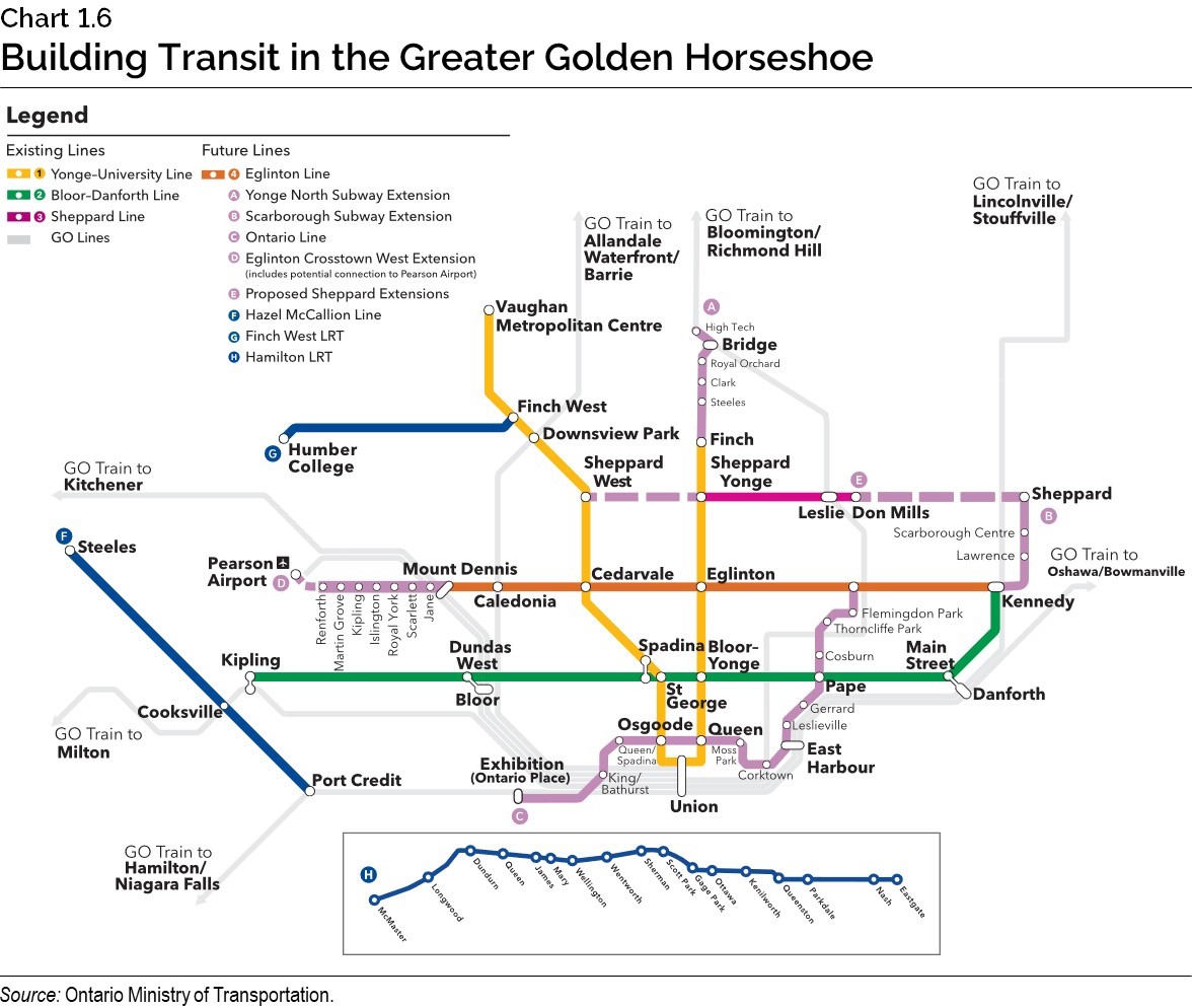
View a larger version of this map (JPG)
Ontario Line
The Ontario Line will bring subway connectivity to currently underserved neighbourhoods such as Liberty Village and Flemingdon Park. It will reduce overcrowding on the TTC’s Line 1 and at Bloor-Yonge Station by up to 15 per cent.
Runs from: Exhibition Station to the intersection of Eglinton Avenue East and Don Mills Road
Length: 15.6 km
Stations: 15
Projected daily ridership: 388,000 boardings
About the project
The Ontario Line is a 15.6 kilometre subway line running from Toronto’s waterfront at Exhibition/Ontario Place, through downtown and eastern Toronto. Current plans for the line include 15 stations, including over 40 connections to GO services, existing subway stations, LRT lines, buses and streetcar lines.
Features
The current scope of work includes:
- a combination of dedicated tracks on existing surface rail corridors, underground, and elevated structures with 15 stations
- a maintenance and storage facility for the subway vehicles
- transit connections to GO services (Lakeshore East and West, Stouffville), existing subway stations, the future Eglinton Crosstown LRT, and the King, Queen, Bathurst, Spadina, Harbourfront and Gerrard streetcar lines
Project benefits
- Improves access to transit by putting over 255,000 people within walking distance to rapid transit.
- Improves quality of life for commuters by reducing daily travel time by up to 40 minutes.
- Reduces crowding by up to 15 per cent on the busiest stretch along the TTC’s Line 1 (Yonge-University) subway.
- Makes 47,000 more jobs accessible by transit (in 45 minutes or less) for Toronto residents.
- Economic and community growth along the future transit line and job creation opportunities.
- Reduction in traffic gridlock, greenhouse gases and fuel consumption by providing an affordable and convenient alternative to driving.
Yonge North Subway Extension
The Yonge North Subway Extension will bring the TTC’s Yonge-University Line (Line 1) north from Finch Station to major employment centres in York Region, such as Vaughan, Markham and Richmond Hill.
Runs from: Finch Station to Richmond Hill Centre
Length: Approximately 8 kilometres
Stations: 5
About the project
The Yonge North Subway Extension is an approximately 8-kilometre extension of the TTC’s Yonge-University Line (Line 1) from Finch Station to Richmond Hill.
The project includes four new stations, including a newly proposed transit hub at Highway 7 and Highway 407 (‘Bridge Station’) that will conveniently connect to as many as five future and existing regional transit lines, as well as local bus services.
The Steeles Station transit hub will connect with local bus routes that serve Toronto and York Region, as well as a future TTC rapid transit line proposed to connect communities along Steeles Avenue.
Features
The scope of work includes:
- an approximately 8-kilometre subway extension, north from Finch Station to Richmond Hill
- train storage facility
- bus terminals
- transit connections to Viva BRT and GO service, and TTC and YRT bus network
Project benefits
- reduces daily travel times for commuters by up to 22 minutes.
- opens up new travel options in York Region through a new transit hub at Bridge Station that will bring together as many as five local and regional transit services
- improves access to transit for area residents where 26,000 more people will be within a 10-minute walk to a station
- economic and community growth along the future transit line with 22,900 more jobs within a 10-minute walk to a transit stop
- make 1,650 more jobs accessible within a 45-minute transit commute to Toronto
- reduction in traffic gridlock, greenhouse gases and fuel consumption by providing an affordable and convenient alternative to driving
Scarborough Subway Extension
The Scarborough Subway Extension will finally deliver the three-stop subway connectivity that residents of Scarborough deserve.
Runs from: Kennedy Station to Sheppard/McCowan
Length: 7.8 km
Stations: 3
About the project
The Scarborough subway extension is a 7.8-kilometre extension of TTC’s Line 2 Bloor-Danforth Subway, from the existing Kennedy Station northeast to McCowan Road and Sheppard Avenue. The line will include three new stations at Lawrence Avenue and McCowan Road, Scarborough Centre and a terminal station at McCowan Road and Sheppard Avenue.
Features
The scope of work includes:
- 7.8-kilometre extension of Line 2 (Bloor-Danforth) subway
- tunneling work for the length of the alignment
- three new stations: Lawrence Avenue and McCowan Road, Scarborough Centre and a terminal station at McCowan Road and Sheppard Avenue
- emergency exit buildings, traction power substations and modifications at Kennedy Station
- transit connections to the TTC’s Line 2, Line 5 (Eglinton Crosstown LRT), GO train (Stouffville line) and bus service, Durham Region Transit bus service and local TTC bus connections
Project benefits
- improves access to reliable rapid transit for area residents
- reduces daily travel times for commuters
- economic and community growth along the future transit line with 34,000 more jobs within a 10-minute walk to a station
- reduction in traffic gridlock, greenhouse gases and fuel consumption by providing an affordable and convenient alternative to driving
Eglinton Crosstown West Extension
The Eglinton Crosstown West Extension will improve connectivity along Eglinton Avenue, including a planned connection to Toronto Pearson International Airport.
Runs from: Future Mount Dennis LRT station to Renforth Drive
Length: 9.2 km
About the project
The Eglinton Crosstown West Extension is an approximately 9.2-kilometre extension of the Eglinton Crosstown LRT (future Line 5), from Mount Dennis to Renforth Drive.
Plans are also being explored for a potential connection to Toronto Pearson International Airport, the single largest employment centre in Canada.
Features
The scope of work includes:
- a 9.2-kilometre extension of the Eglinton Crosstown westward, with seven stops from the future Mount Dennis LRT station to Renforth Drive
- ultimately, through future phases, the province is committed to establishing connectivity with Toronto Pearson International Airport
- convenient links to other destinations throughout the region – UP Express and Kitchener Line GO train service at Mount Dennis, TTC bus services at all transit stops in Toronto, and MiWay and GO Bus services via the Mississauga Transitway at Renforth
Project benefits
- Improves access to transit for area residents.
- Reduces daily travel times for commuters.
- Economic and community growth along the future transit line with 31,000 more jobs within a 10-minute walk to a station.
- Reduction in traffic gridlock, greenhouse gases and fuel consumption by providing an affordable and convenient alternative to driving.
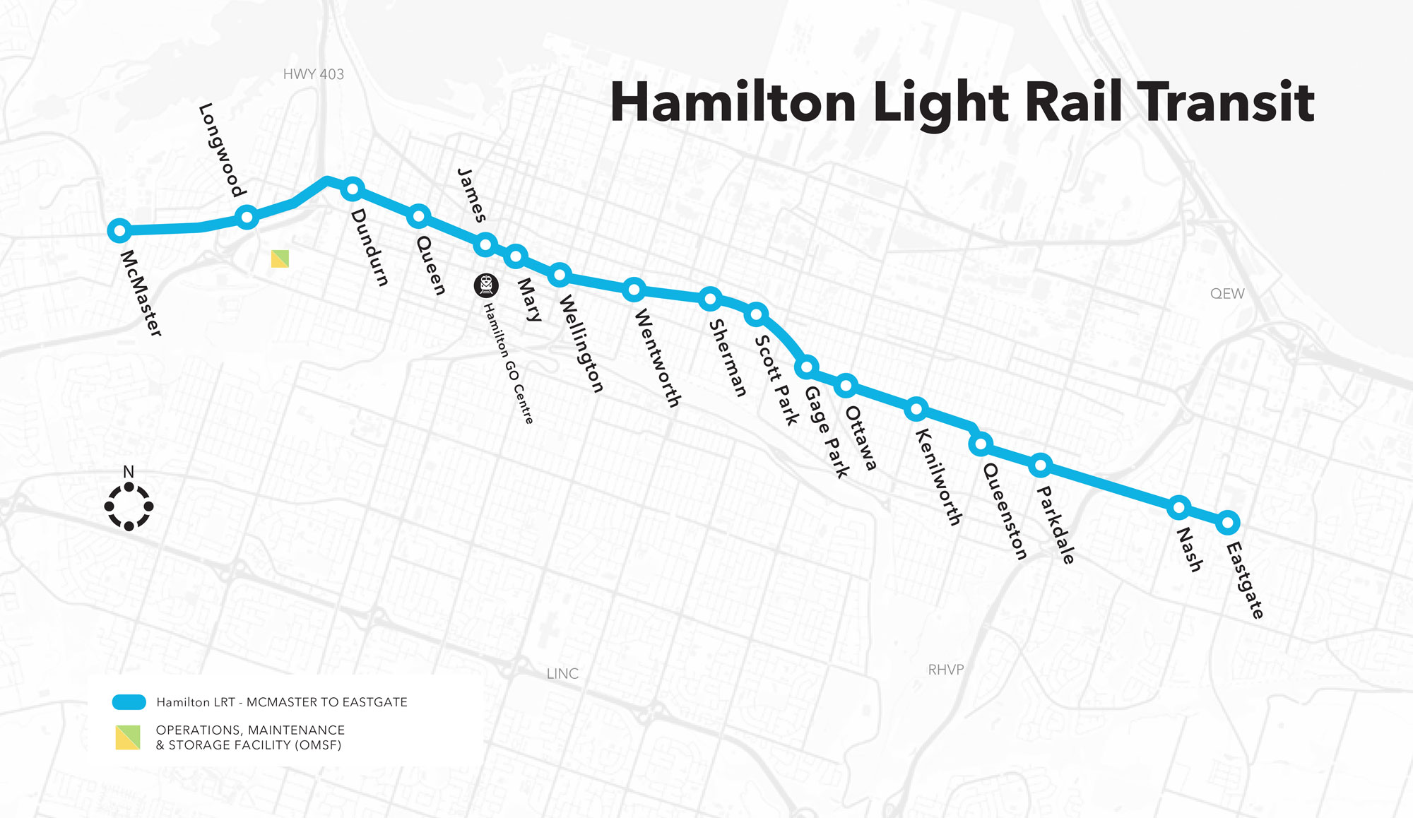
About the Hamilton Light Rail Transit (LRT)
The Hamilton LRT project will offer frequent and reliable connections on the 14-kilometre line from Eastgate Square through downtown Hamilton to McMaster University.
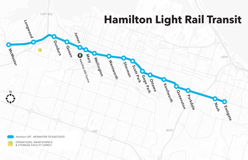
View a larger version of this map (.jpg)
Runs From: McMaster University to Eastgate Square
Length: ~14 km
Stations: ~17
About the project
The Hamilton LRT will be a 14-kilometre brand new higher-order transit line running from McMaster University through downtown Hamilton to Eastgate.
Project benefits
- Increases connections to key anchor institutions and transit hubs including McMaster University, City Hall, Tim Hortons Field and Eastgate Square.
- Drives greater mode shifts from auto vehicles to public transit, which will reduce greenhouse gas emissions and help the City meet its transit mode share targets.
- Helps increase investment, development and land values along the corridor.
Hazel McCallion Light Rail Transit (LRT) extensions
The Hazel McCallion LRT will be extended into downtown Mississauga and a downtown Brampton extension.
The downtown Mississauga LRT extension will be about a 2 kilometre loop and will increase access to major destinations in Mississauga’s downtown core. The downtown Brampton Main Street will be about a 4 kilometre extension of the LRT north from the Brampton Gateway Terminal at Steeles Avenue East.
Project benefits
- Increasing access to transit in growing employment areas
- Reducing road congestion
- Helping attract business and investment to both cities at a faster timeline
Other Projects
Learn more about other priority public transit projects.
Learn more about other priority public transit projects.