Rose Lake Dune Peatland Complex Conservation Reserve Management Statement
This document provides policy direction for the protection, development and management of the Rose Lake Dune Peatland Complex Conservation Reserve and its resources.
Statement of Conservation Interest (SCI)
Ministry of Natural Resources
Algoma Area
Sault Ste. Marie District
February 12, 2003
Ce document est seulement disponsible en anglais.
Approval statement
I am pleased to approve this Statement of Conservation Interest (SCI) for the Rose Lake Dune Peatland Complex Conservation Reserve (C260).
The Rose Lake Dune Peatland Complex Conservation Reserve offers a unique peatland basin and represents the best example of moderately broken shallow sand till uplands on bedrock in this area. Regulated on April 6, 2001, this 275-hectare conservation reserve is directly north of the Town of Bruce Mines and is located in the Territorial District of Sault Ste. Marie, in Northeastern Ontario.
Direction for establishing, planning and managing conservation reserves is defined under the Public Lands Act and current policy. The direction for managing this conservation reserve is in the form of a SCI, which defines the area that is being planned, provides the purpose for which the conservation reserve has been proposed, and outlines the Ministry of Natural Resources' intent for the protected area. This SCI will provide both guidance for the management of the conservation reserve and the basis for ongoing monitoring of activities. More detailed direction at this time is not anticipated. However, should significant facility development be considered or complex issues arise requiring additional studies, more detailed management direction, in the form of special protection measures, or a detailed Resource Management Plan will be prepared with full public consultation.
Public and Aboriginal consultation occurred prior to the regulation of this Conservation Reserve during the planning for Ontario’s Living Legacy (OMNR 1999). Furthermore, there was a 15-day review period in January 2002 concerning a draft of this SCI. Comments from the review period have been considered in the development of this document.
This SCI will be implemented by the Algoma Area Supervisor, with input from the North Shore Supervisor, and will be reviewed every five years and amended as required by the District Planner, Sault Ste. Marie District, Ministry of Natural Resources.
Submitted by:
Erin Nixon
Date: February 21, 2003
Recommended
For Approval and Signed by:
Serge Tenaglia R.P.F.
District Manager
Sault Ste. Marie District
Date: March 04, 2003
Signed by:
Rob Galloway
Regional Manager
Northeast Region
Date: May 30, 2003
1.0 Introduction
The following document is a Statement of Conservation Interest (SCI) for the Rose Lake Dune Peatland Complex Conservation Reserve. The purpose of this SCI is to identify and describe the values of the Rose Lake Dune Peatland Complex Conservation Reserve and to outline the Ministry of Natural Resources' management intent for this area. The first portion of the document outlines the Provincial context in which it was produced, states its goal and objectives and summarizes the planning process for conservation reserves. The second portion of this document is specific to the Rose Lake Dune Peatland Complex Conservation Reserve, providing a detailed description of the site, and outlining the management strategy for the area.
The management direction provided within this SCI will serve to protect the conservation reserve for the benefit of all Ontario residents. This direction will comply with land use intent as stated in the Ontario’s Living Legacy Land Use Strategy (OMNR 1999).
1.1 Provincial context
Ontario’s network of natural heritage areas has been established to protect and conserve areas representative of the diversity of the natural regions of the province, including species, habitats, features and ecological systems which comprise that natural diversity. Protected natural heritage areas are a key component in the sustainable management of natural resources. They ensure that representative sites within the larger managed landscape are permanently retained in their natural state. The Rose Lake Dune Peatland Complex Conservation Reserve is part of Ontario’s network of natural heritage areas.
On July 16, 1999, the Ontario Government released the Ontario’s living Legacy Land Use Strategy to guide the planning and management of Ontario’s Crown lands. Extensive consultation was conducted during the development of the Land Use Strategy. The objectives of the Land Use Strategy (OMNR 1999) are to complete Ontario’s system of parks and protected areas; recognize the land use needs of the resource-based tourism industry; provide forestry, mining and other resource industries with greater certainty around land and resource use; and enhance hunting, angling and other Crown land recreation opportunities.
The Land Use Strategy (OMNR 1999) demonstrated the government’s commitment to completing Ontario’s system of protected natural heritage areas by designating 378 new areas to be protected. These areas are considered to be significant and require protection from incompatible activities in order for their values to endure over time. The addition of these 378 new areas marks the largest expansion of parks and protected areas in Ontario’s history. The Rose Lake Dune Peatland Complex Conservation Reserve was created as part of this expansion.
The Ministry of Natural Resources has established conservation reserves as a tool to protect natural heritage areas on public lands, while permitting traditional public land uses to continue. These uses include recreational activities, such as hunting and fishing, and the traditional activities of Aboriginal societies, as defined under applicable Aboriginal treaties. Lands designated as conservation reserves in the Land Use Strategy (OMNR 1999) are removed from the Sustainable Forest Licence, and mining and surface rights are withdrawn from staking under the Mining Act (RSO 1990 Chapter M.14).
Ontario’s Living Legacy Land Use Strategy (OMNR 1999) outlines the general land use policy and management direction for new conservation reserves. Each new conservation reserve will have a planning document, either a SCI or, in more complex situations, a Resource Management Plan, that details site-specific management direction.
2.0 Goal and objectives of the SCI
2.1 Goal
The goal of this SCI is to provide the framework and direction to guide management decisions affecting the Rose Lake Dune Peatland Complex Conservation Reserve.
2.2 Objectives
The following objectives are identified as the means to achieve the above stated goal.
- To describe the state of the resource with respect to the values mentioned in Section 5.0 and current land use activities
- To outline the Ministry of Natural Resources' management intent for the protected area
- To determine the land use compatibility of current land uses, and to develop specific guidelines and prescriptions to manage these uses
- To create public awareness of the values, as mentioned in Section 5.0, within this conservation reserve by providing information on the resources that it contains and protects; and to promote responsible stewardship of the protected area through partnerships with local stakeholders
- To determine the long-term management goals for the conservation reserve by identifying research, client services, and marketing strategies necessary to position this conservation reserve among the system of parks and protected areas in Ontario
- To identify the scientific values on the site in relation to provincial benchmarks and identify the necessary monitoring and/or research to maintain the integrity of those values
- To provide direction for the evaluation of proposed new uses or economic ventures through the application of the Test of Compatibility (Appendix A). This test will evaluate the impact of suggested use(s), either positive or negative, on the protected values of the conservation reserve
3.0 Management planning
3.1 Planning for a Conservation Reserve
The planning process for a conservation reserve consists of defining site boundaries and preparing a site specific management plan. Public, Aboriginal and industry consultations occur during the planning process. When the boundaries of the site are finalized and the Ministry of Natural Resources' approval process is complete, a conservation reserve becomes regulated. Once a conservation reserve is regulated, the level of management planning required to fulfill the protection targets is determined, and either a basic or an enhanced SCI or a Resource Management Plan is prepared. A basic SCI is prepared when no new decisions are made beyond those mentioned in the Ontario’s Living Legacy Land Use Strategy (OMNR 1999), whereas an enhanced SCI is prepared when one or more decisions are made beyond those mentioned in the Strategy (OMNR 1999). A Resource-Management Plan is prepared in more complex situations where a-number of issues have to be addressed. Whichever the determination, the plan must be completed within three years of the conservation reserve’s regulation date. The guidelines for the preparation of these documents are provided in Procedural Guideline A- Resource Management Planning (Conservation Reserves Procedure PL3.03.05, Public Lands Act).
A SCI is essentially a management plan based on the management direction provided in the Land Use Strategy (OMNR 1999). The purpose of a SCI is to identify the state of the resource with respect to the values mentioned in Section 5.0 and current land use activities and to outline the Ministry’s management intent for the conservation reserve. SCI is typically go through a public review period of 15 days. Upon completion of this public review, the SCI is revised as appropriate and approved by the Ministry of Natural Resources' Regional Director.
Existing permitted uses within conservation reserves may continue, unless they are shown to have a significant negative impact on the values protected by the site. A review/evaluation mechanism is in place to address proposed new permitted uses, or land use proposals. The Test of Compatibility as outlined in the Public Lands Act Policy PL 3.03.05 (OMNR 1997) and/or other standard Ministry of Natural Resources' environmental screening processes, is used to screen future proposals. Where cultural resources may be impacted, proposals may be screened through Conserving a Future for our Past: Archaeology, Land Use Planning & Development in Ontario, Section 3 (MCzCR 1997), in a manner similar to that used by the Ministry of Natural Resources in the forest management planning process.
Public comment may be solicited during a review of any future land use proposals that require new decisions to be made. Appropriate environmental assessment (EA) requirements and amendment processes will apply to any future proposal and/or any significant change in management direction being considered for a site.
3.2 Planning process for the Rose Lake Dune Peatland Complex Conservation Reserve
Rose Lake Dune Peatland Complex Conservation Reserve (C260) was proposed as a conservation reserve in the 1999 Ontario’s Living Legacy Land Use Strategy by the Ontario Ministry of Natural Resources. Public, Aboriginal and industry consultation has taken place and the boundary of the site has been finalized. The site was formally regulated through an amendment to Ontario Regulation 805/94 of the Public Lands Act on April 6th, 2001, by Ontario Regulation 86/01.
To date, no significant issues related to land use in this area have been identified. For this reason, it was determined that a basic SCI will adequately identify the conservation reserve’s significant features and address the management guidelines. Therefore, the Rose Lake Dune Peatland Complex Conservation Reserve will be managed under the auspices of a SCI. It should be noted that this SCI addresses only those issues or land use proposals currently known to the District Manager. The direction provided by this SCI, and future management decisions, will resolve any future land use conflicts and will ensure that identified values continue to be adequately protected.
3.2.1 Planning area
The planning area for this SCI consists of the regulated boundary for the Rose Lake Dune Peatland Complex Conservation Reserve (see Section 10, Map 1). However, to fully protect values within the conservation reserve, additional consideration within larger land use planning initiatives may be required. The forest management planning process is an example of how adjacent land management may consider sensitive features within the conservation reserve boundary.
3.3 Guiding principles
All current or planned activities within this conservation reserve will be in compliance with the following guiding principles. If a conflict between management guidelines exists, the following guiding principles will be used to discern management intent and resolve the issue.
- All management guidelines will be based on maintaining the long-term ecological integrity of the area
- No new or existing uses will be permitted if it is deemed the protected values mentioned in Section 5.0 will be compromised
- All attempts will be made to maintain traditional uses while protecting the values mentioned in Section 5.0 and while maintaining the long-term ecological integrity of the site
- This conservation reserve was chosen to represent vegetation and landscape types unique to this site district and to Ontario. All efforts will be made to maintain those values as identified in Section 5.0
- Overall, management strategies will focus on maintaining the conservation reserve in as natural a state as possible
4.0 Background information
4.1 Location and site description
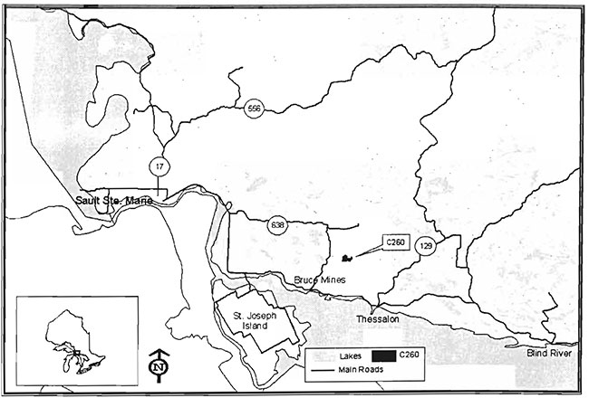
Rose Lake Dune Peatland Complex Conservation Reserve is located approximately 14 km due north of the Town of Bruce Mines and encompasses much of the north shore of Rose Lake in Rose Township (Section 10.0, Map 1). Whenever possible, natural and/or artificial features (i.e. roads, corridors, and rivers) have been used to delineate site boundaries to facilitate easy on-the-ground identification of the boundaries.
The conservation reserve can be accessed from the east via Mt. Zion Road. Unnamed roads make up portions of all boundaries of this site making it easily accessible.
The following table describes the location and administrative details of the site:
Table 1: Location and administrative details for the Rose Lake Dune Peat/and Complex Conservation Reserve.
| Name | Rose Lake Dune Peatland Complex Conservation Reserve |
|---|---|
| Site Region - Site District (Hills) | 5E Georgian Bay 5E-1 Thessalon |
| Site region - Site District (Crins and Uhlig) | 5E-1 |
| Ministry of Natural Resources Administrative Region/District/ Area | Northeast Region/Sault Ste. Marie District/Alqoma Area |
| UTM co-ordinates | 296000 E, 5140000 N |
| SCI completed | February 12, 2003 |
| Regulated | April 6, 2001 |
| Area 275 ha | |
| Nearest Town/Municipality | Approximately 14km north of the Town of Bruce Mines |
| Township(s) | Rose |
| OBM Numbers | 2017290051300 2017290051400 |
| Topographical Map Name/Number | Bruce Mines 41J5 |
| Wildlife Management Unit | WMU# 36 |
| Forest Unit | Algoma Forest |
4.2 History of the site
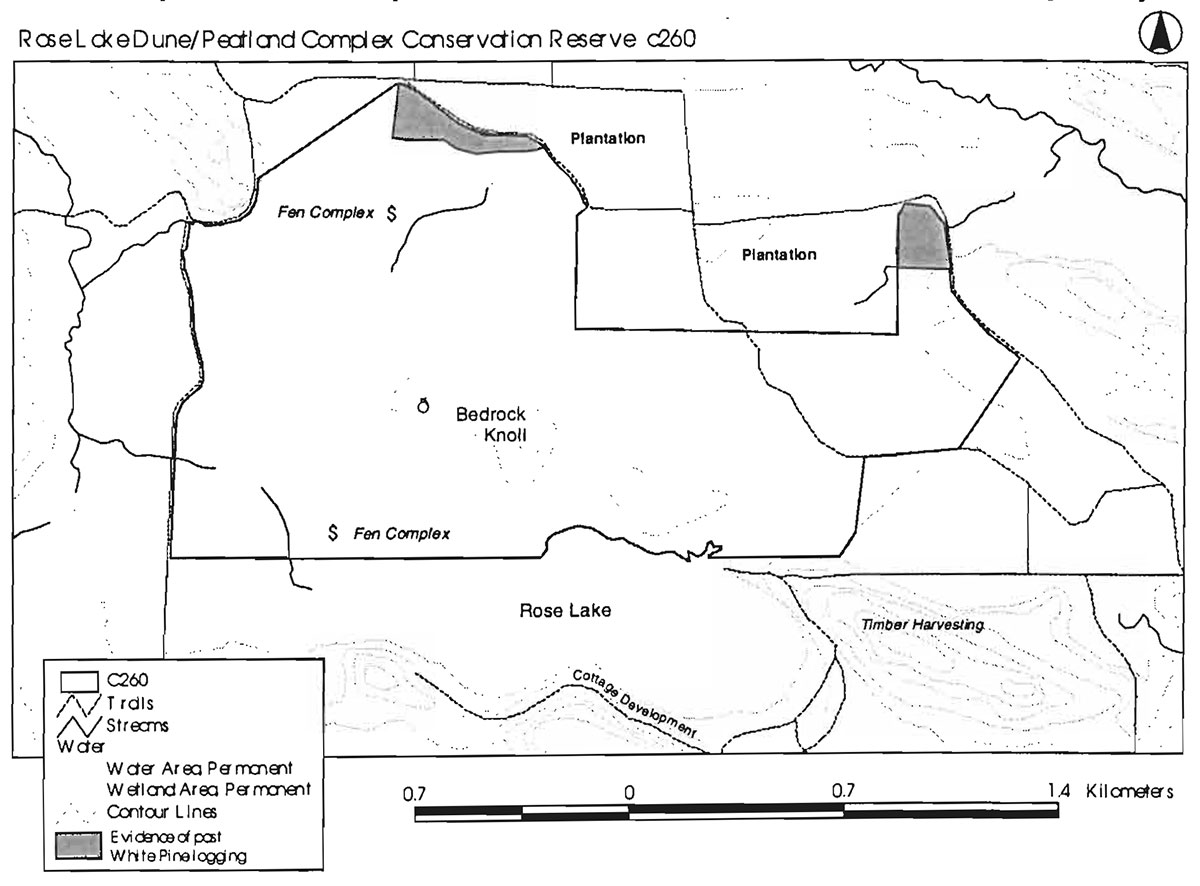
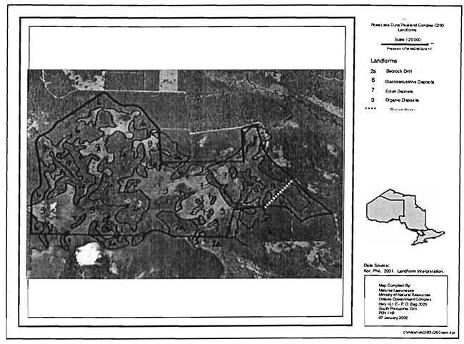
The Kirkwood Delta is an outwash plain formed by a receding glacier. The deposited sand was then shaped by the wind and channeled down the northwest valley into dunes. The Rose Lake Dune Peatland Complex Conservation Reserve is located on the southern portion of the Kirkwood Delta and contains a dune complex interspersed with wetlands.
Beaver (Castor canadensis) activities occur in the northeast and southwest marshes. These animals have increased the water retainment capacity by restricting water flow out of the area, possibly contributing to the creation of the swamps that they inhabit. Timber harvesting activity has occurred on the periphery of the north side of the conservation reserve, evidenced by the large white pine stumps remaining on the site. Mature plantations of Scots Pine (Pinus sylvestris L.) and Red Pine (Pinus resinosa Ait.) are located just north of the wetland. Roads skirt the wetland, forming the north and west boundaries of the conservation reserve. Timber harvesting operations have occurred to the southeast, and there is cottage development along the south and east shores of Rose Lake.
Table 2: Inventory and Survey Information for Rose Lake Dune Peat/and Complex Conservation Reserve
Aerial and field surveys were carried out in 2000-2001in support of the preparation of this SCI. Table 1 provides geographic information for the site. The surveys (past and present) form the basis of the values' description.
4.3 Inventories
Table 2 indicates the current status of natural heritage inventories that have occurred and/or are required for the Rose Lake Dune Peatland Complex Conservation Reserve.
| Survey Level | Easrth Science | Life Science | Cultural | Recreational |
|---|---|---|---|---|
| Reconnaissance | 2000 | 2000 | 2000 | 2000 |
| Detailed | Not required | 1998 (Bergsma) | Not required | Not required |
| Further Requirements | Future ground surveys could be considered to enhance knowledge of life science values | All recreational trails should be identified and mapped using GPS technology. (Global Positioning) |
5.0 State of the resource
The key values (geological features and/or featured species) found within Rose lake Dune Peatland Complex Conservation Reserve include the following:
- The best representative example within the site district/region of moderately broken shallow sandy till uplands on bedrock
- The peatland basin, which supports classic bog communities
- High landform and vegetative diversity with an interesting landform pattern that is oriented from northwest to southeast
- The presence of dune fields that are regionally/provincially significant
The key values are those values that make this site unique and have led to its designation as a conservation reserve. Their protection is paramount. Additional values as listed in Section 5.1 through to Section 5.5 are also important. This description is not necessarily complete. If new values are identified, they will be added to this section. If any new value is considered significant, management guidelines may be modified, if required, to ensure its protection.
5.1 Earth sciences
This conservation reserve contains an aeolian sand dune-peatland complex. Dune ridges surround peat deposits occupying interdunal swales or depressions to form an intricate pattern. The dunes were created by wind action on a freshly deposited sandy outwash plain formed by a receding glacier. The dunes are somewhat distorted, likely because of changing wind direction during formation. The dune field is situated at the apex of a large, provincially significant raised delta (i.e. "hanging" or "perched" sand flat) known as the Kirkwood Delta. The dunes probably formed on the exposed surface of the delta when the post-Algonquin lake Cedar Point fell to the Payette level
A bedrock knoll is exposed in the middle of the wetland, north of the Rose lake shore. This knoll is part of a ridge structure (perhaps a diabase dyke) that touches the eastern end of the lake (OMNR, 2000).
Dune fields are relatively rare on a provincial scale and are ranked as provincially significant features. They are even more rare within the context of the North Channel shoreline and the immediate hinterland that was inundated during and following the Main Algonquin lakes' period. According to the earth science surveyor, the geography of this site requires a high level of protection (OMNR, 2000).
5.2 Life sciences
The majority of the area of this conservation reserve consists of various types of wetland formations. Creeks flow out of the southwest and northeast corners. Assisted by beaver activity, the headwaters of these creeks have become open water marshes that extend beyond the site’s boundaries. A small fen complex exists in the northwest corner and in portions of the southern half of the conservation reserve, with the remainder of the southern half consisting of an open peatland with very few trees. On the dune ridges and highlands, naturally occurring forests exist consisting primarily of aspen (Populus tremuloides Michx.), black spruce (Picea mariana) and eastern white cedar, with minor components of white birch (Betula papyrifera Marsh.-) and larch (Larix laricina (Du Roi) K. Koch).
The site is centered on a sand dune-peatland complex wherein sand dunes stick out of the surrounding peat basins, thus forming an intricate pattern. Some of the sand ridges support a black spruce/lichen woodland community, which is regionally significant. Other ridges support blueberry heaths, low shrub thickets, eastern bracken fern meadows and open white birch/bracken fern woodlands that may be the result of disturbances.
This site was identified as regionally significant in part due to functions such as the carbon sink capability and water quality improvement that the wetland performs. Banner and Mackenzie (2000) describe more tangible benefits of wetlands such as the increase in wildlife habitat created by the natural edge between the wetland and the forest. In the Rose Lake area, the surrounding forests provide habitat and cover for wildlife species that also benefit from high prey densities and excellent forage opportunities within the wetland itself. The Rose Lake Peatland has been identified as a historic deer wintering area and a nesting site for sandhill cranes (NRVIS 2001).
The Rose Lake wetland abuts the north side of Rose Lake and may play a significant role in the health of the lake. The wetland also acts as a headwater to Rock Lake, draining into Rose Lake and Mckinnon River, both of which eventually drain into Rock Lake. The water levels of Rose Lake are maintained at constant levels during rainfalls in part because of the retention and slow release of the water from the Rose Lake wetland. The wetland acts as a sponge, storing large amounts of incoming water and releasing it a little at a time (OMNR, 1993).
5.3 Recreational values
The presence of the wetland in conjunction with the adjacent mature forest creates favorable habitat for numerous game species such as moose (Aices alces), white-tailed deer (Odocoileus virginianus) and waterfowl. Moose hunting, as well as other hunting opportunities, are known to be an important value of this wetland for the surrounding communities.
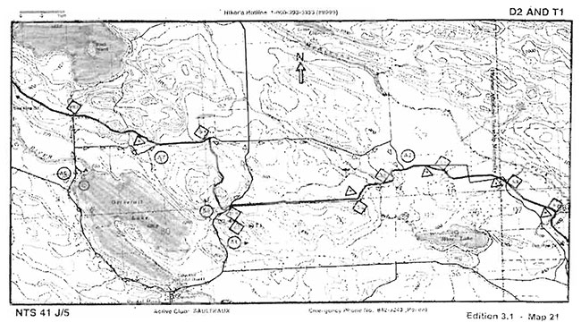
The Voyageur Trail System transects the extreme northeast corner and abuts portions of the north side of the conservation reserve (Section 10.3). The Voyageur Hiking Trail Guidebook addresses the large white pine stumps, which are all that remain of the original forest. These remnants are from logging that occurred from 1870 to 1880, with the forest in that area since replaced by Red and Scots Pine plantations. Two other partial trails also enter the conservation reserve, and are likely used by hunters to access the wetland.
A number of trails run by the Ontario Federation of Snowmobile Clubs (OFSC) border this conservation reserve. Along the north side, a snowmobile trail parallels Mt. Zion Rd. Another trail exists on the west side starting at East Line Road and continuing north to Mt. Zion Rd.
The Ministry of Natural Resources has not completed a lake survey on Rose Lake; however, some fishing pressure may arise from the cottage subdivision located along the east and southeast edge of Rose Lake. No public access point currently exists on Rose Lake.
5.4 Cultural values
This site falls within the Robinson-Huron Treaty Area. No First Nation community has to date identified any specific cultural values within this conservation reserve.
5.5 Research values
Palynologists have discovered that peat deposits provide a record of past vegetation and climate change through the analysis of preserved fossil pollen and spore rain (Moore 1991). The peatland in this conser-Vation reserve may have the potential to contribute to current research on such items as global warming and climate change.
The nearby northern plantations and the numerous roads surrounding the conservation reserve may prove valuable to the study of how intensive forest management and road creation impact on wetlands. According to Banner (2000), the impact of forestry operations on wetlands has not been adequately researched.
6.0 Management guidelines
All management guidelines in this SCI are based on policy and direction outlined in the Ontario Living Legacy Land Use Strategy (OMNR, 1999) and associated policy clarification statements. Management policies in this document may be subject to change and may be amended as necessary. These guidelines are specific to Rose Lake Dune Peatland Complex Conservation Reserve, and provide for protection of the site’s unique features.
New proposed use and development as well as research and education will be reviewed on a case-by-case basis. Where applicable, proposals will be subject to the Test of Compatibility (Appendix A- PL 3.03.03, Public Lands Act), with reference to Conserving a Future for our Past: Archaeology, Land Use Planning & Development in Ontario, Section 3 (MCzCR 1997). In addition, new proposals are subject to the Class Environmental Assessment for Parks and Conservation Reserves.
The following management strategies have been created to achieve the goal and objectives of this SCI with regard to the Rose Lake Dune Peatland Complex Conservation Reserve.
6.1 Industrial activities
6.1.1 Commercial timber harvest
The area contained within this conservation reserve has been withdrawn from the Algoma Sustainable Forest Licence area (253 ha) as well as the North Shore Sustainable Forest Licence area (20 ha), and no commercial timber harvesting will be permitted. Please refer to Section 6.4.3 for information regarding non-commercial harvesting of wood.
6.1.2 Mining and exploration
There are no known current mining interests related to the conservation reserve. Mining and surface rights have been withdrawn from staking within the conservation reserve’s boundaries under the Mining Act (RSO 1990 Chapter M.14). Mineral exploration is not permitted.
6.1.3 Extraction of peat, soil, aggregate and other material
Extraction of peat, soil, aggregate and other material is not permitted.
6.1.4 Energy generation
Hydropower development and windpower generation is not permitted.
6.2 Existing and proposed development
6.2.1 Transportation corridors
6.2.1.1 Roads
According to the Land Use Strategy (OMNR 1999), new roads for resource extraction will not be permitted, except for those identified in Forest Management Plans prior to March 31, 1999. This process identified no new or existing roads for resource extraction within this site. There is, however, a road that forms a portion of the boundary of this conservation reserve, which was identified in the Algoma Forest: Existing Roads Listing as a requirement into the future to access the red pine plantation just north of the conservation reserve’s boundary.
An abandoned Crown road exists within this conservation reserve. This road cuts across the eastern side of the conservation reserve in a north-south direction. Unnamed roads make up portions of the south, east and west boundaries. A portion of the northern boundary follows Mt. Zion Road.
Existing Crown roads contained within this conservation reserve are permitted to continue but will not be maintained by the Ministry of Natural Resources. Maintenance by area users may be permitted, subject to appropriate approvals to ensure the protected values of the site are not compromised. Should protected values of the site be compromised, the Ministry of Natural Resources may consider appropriate provisions under the Public Lands Act to ensure their protection.
6.2.1.2 Trails
Access to this site is readily available due to the extensive road infrastructure in close proximity to the boundaries of the conservation reserve.
The Voyageur Hiking Trail currently crosses a small sliver of the northeast portion of this site. This and other existing and/or authorized trails can continue unless there are significant demonstrated conflicts. The abandoned Crown road which cuts across the east end of the conservation reserve in a north-south direction is permitted to be used as a trail for approved recreational activities.
Any future trail development must consider the conservation reserve’s core values that are protected within the boundaries of this site. Trail development in low-lying areas and wetlands will be discouraged. Any proposed new trails will be subject to the work permit review process and the Test of Compatibility screening process (Appendix A). As a condition to any new trail development, all new and existing trail heads and trail routes must be identified using new technologies (ie. global positioning systems) to ensure the most accurate record of the feature. If new trails are approved, an amendment to this SCI will occur.
6.2.2 Other corridor development/maintenance
There are no communication, energy transmission, or other non-road corridors within this conservation reserve. New corridor developments will be actively discouraged through planning. Proposals for new corridors will be subject to the Test of Compatibility (Appendix A) and applicable district policies.
6.2.3 Land disposition
No land will be sold within the boundaries of this conservation reserve.
6.2.4 Land tenure
Presently no Land Use Permits (LUPs) or leases exist within this conservation reserve. With the exception of private recreation camps, new leases or land use permits may be issued for other approved uses subject to the Test of Compatibility (Appendix A) and applicable district policies. These forms of land tenure will not be patented or phased out but may be eligible for enhanced tenure or transfer. Enhanced tenure is defined as anything beyond the term and form of current tenure. All requests for transfer or enhanced tenure will be subject to the following screening criteria:
- Is the transfer or enhanced tenure consistent with the conservation reserve’s land use intent, which is the protection and enhancement of the site’s natural, recreational and cultural values?
- Is it consistent with the land disposition policies outlined in the District Land Use Guidelines, this SCI and any other applicable document?
- Does it adversely affect the values mention in Section 5.0, and/or conflict with other uses?
- Is land needed by the Crown to protect significant natural or recreational values outlined in this SCI?
- Does the transfer or enhanced tenure clash with Aboriginal traditional uses, land claims or agreements?
- Are all rents, taxes, fees, rates or charges paid up for the existing LUP or lease?
6.3 Commercial activities
6.3.1 Commercial bait harvesting
No active commercial bait harvest operations or licenses exist within this conservation reserve. New operations can be considered subject to the Test of Compatibility (Appendix A) and applicable district policies.
Under the Public Lands Act and in conjunction with PL 3.03.08 Buildings for Bait Harvesting Management, cabins for the purpose of bait harvesting may be constructed on Crown land. However, the construction of such buildings within this conservation reserve should be avoided, and be directed to Crown land outside of the protected area wherever possible.
6.3.2 Commercial fishing
There are no commercial fisheries within this conservation reserve.
Activities may be considered; see Section 6.2.1.2 for more details related to trail development.
While camping is permitted within the conservation reserve, campers should make use of established campsites, where they exist, and avoid sensitive areas such as wetlands.
6.4.2 Natural Heritage Appreciation facilities/aecreational structures
Within this conservation reserve, there are no existing authorized natural heritage appreciation facilities or recreational structures such as boardwalks, bird viewing platforms, kiosks, ski shelters or interpretative signs. New natural heritage appreciation facilities and recreation structures are encouraged and permitted, subject to the Test of Compatibility (Appendix A).
6.4.3 Non-commercial consumptive resource use
Cutting of trees for non-commercial purposes within this conservation reserve may be authorized by permit, issued by the local Ministry of Natural Resources' office, subject to a review and determination of the impact that such cutting would have on the values mentioned in Section 5.0. This flexibility is intended only for leaseholders, Land Use Permit holders, cottagers and other property owners within the conservation reserve who do not have road access to their property and have no alternative wood source outside of the conservation reserve. This permit is intended to cover fuelwood, dock stringers, and other occasional small scale uses.
Non-commercial harvesting of non-timber forest products such as berries, mushrooms, sphagnum moss (Sphagnum spp.) and wild rice (Zizania L.) can occur as long as the values mentioned in section 5.0 are not jeopardized.
6.4.4 Hunting and fishing
Hunting is a traditional use and has been identified by various stakeholders as an important value of this area. In conjunction with current hunting regulations and adherence to the guiding principles (Section 3.3) of this conservation reserve, hunting is permitted to continue.
Recreational fishing is also permitted in compliance with current fishing regulations.
6.4.5 ATV and snowmobile use
Existing trails for snowmobiling and ATV use can continue. To ensure the quality of the representative values are maintained, all trails within the site will be monitored to ensure the protection of these values, as outlined in Section 5.0. In addition, all access routes and points should be captured digitally (i.e. GPS) to ensure an accurate record of these features. New trails can be considered through the Test of Compatibility (Appendix A). If new trails are approved, then an amendment to this SCI will occur. Please refer to Section 6.2.1.2 for more information on trails.
In general, off-trail use of ATVs and snowmobiles is not permitted within this conservation reserve. However, off-trail use is accepted for licenced trappers to access their traplines and for licenced bait harvest operators while conducting harvest operations. Off-trail ATV and snowmobiling is also accepted for the direct retrieval of large game by hunters and of bears harvested within a current BMA. In all cases, off-trail use is only permitted provided the
7.2 Future needs and considerations
The following recommendations should be considered in any future planning initiatives for this conservation reserve:
- Efforts should be made to work with partners (such as Sault College of Applied Arts and Technology) to gather baseline data on this site. This data will be used for future monitoring and inspection activities when required
- Efforts should be made to obtain funding to support further inventory requirements for this site
- Global Positioning System technology should be employed to document the current status of access points and trail routes that border and/or run through portions of the site
- The peatland, dune areas, and vegetative communities represented within the site could be sensitive to trail development, especially during the non-winter months. Considering the significance of the site, the sensitivity of the values present (aeolian and peatland deposits), the site’s small size, and the existing trail network available along the site’s boundaries and within the site (i.e. northeast corner of the conservation reserve), future trail development must be sensitive to the key values
- Due to the proximity of developed private land and the potential for a high degree of public use of this conservation reserve, control measures may need to be implemented to ensure that the site’s values, as identified in Section 5.0, are not negatively Impacted
- Any future economic or development proposals for the site will need to go through the Test of Compatibility screening process (Appendix A) that considers, but is not limited to, the following: the current quality of representation within the site, significance and sensitivity of the values present, objectives of such proposals, abilities to provide economic opportunities outside of the site, option development, etc.
- The site should be reviewed as a potential IMAR (Inventory, Monitoring, Assessment Reporting) and/ or Research candidate due to the peatland basin as well as the regionally/provincially significant dune fields
- Further analysis and classification of the vegetative communities within the site, especially the peatland areas, should be considered in any future assessment of the site
- Due to the sensitivity of wetland areas to human pressures, consideration should be given to protection of the wetlands that extend beyond the site’s boundaries
- There is a need for increased awareness regarding wetland sensitivity and knowledge of current research on the most effective means to protect a wetland that is closely surrounded by human disturbance
7.3 Monitoring
Periodic monitoring of human activities within this conservation reserve will be conducted. A schedule for cursory field monitoring will be identified within the District’s annual compliance plan and an Integrated Field Monitoring (IFM) Inspection Report form will be filed at the Sault Ste. Marie District Office. The Algoma Area Supervisor will oversee these activities, with input from the North Shore Supervisor. If at any time human activities are deemed to be negatively impacting the protected features, the activities will be reviewed and measures taken to mitigate any disturbance.
Approved inventory, monitoring, assessment or research activities that are compatible with protection objectives are encouraged. Any area that is disturbed during research activities is to be rehabilitated as closely as possible to its original condition. The Algoma Area Supervisor and/or North Shore Area Supervisor may apply additional conditions.
9.0 Literature cited
Allison, T et al., 1996. Voyageur Hiking Trail Guidebook. The Voyageur Trail Association, Sault Ste Marie. Ontario.
Bergsma, B., 1998. Life Science Gap Analysis for Site District 5E-1. BMB Scientific.
Banner, A. and W. Mackenzie, 2000. The Ecology of Wetland Ecosystems, Extension Note 45. B.C. Ministry of Forests Research Branch, Prince Rupert Forest Region.
Golet, F.C. 1976. Wildlife Wetland Evaluated Model. In Models for the Evaluation of Freshwater Wetlands. J.S. Larson (ed.). Water Resources Research Centre, University of Massachusetts.
MOE. 2000. Order in Council, No.182/2000. Minister of the Environment.
Moore, P.O., J.A. Webb, and M.E. Collinson. 1991. Pollen analysis. 2nd ed. Blackwell Scientific, Oxford, U.K.
Ontario Ministry of Natural Resources, 1983. District Land Use Guidelines (DLUG): Blind River District.
OMNR,1993. Ontario Wetland Evaluation System, Northern Manual. 1st Edition. NEST Technical Manual TM-001.
OMNR, 1997. Trapline building on public land. PL 3.03.06.
OMNR, 1999. Ontario’s Living Legacy Land Use Strategy. Queen’s Printer for Ontario.
OMNR, 2000. C260 Aerial Life, Earth and Recreation Inventory. Sault Ste. Marie District.
OMNR(a), 2001. Sensitive Areas Report. Sault Ste. Marie District.
OMNR(b). 2001. State of the Ontario Forest Accord. Ontario Forest Accord Advisory Board.
OMNR(c). 2001. Application, Review and Land Disposition - Building for Bait Harvesting Management. PL 4.02.01, Schedule A.
Crins, W.J. and P.W.C. Uhlig. 2000. Ecoregions of Ontario: Modification to Angus Hills' Site Regions and Site Districts- Revisions and Rationale.
Hills, G.A. 1959. A Ready Reference for the Description of the Land of Ontario and its Productivity. Preliminary Report. Ontario Department of Lands and Forests. Maple. Ontario.
10.0 Maps
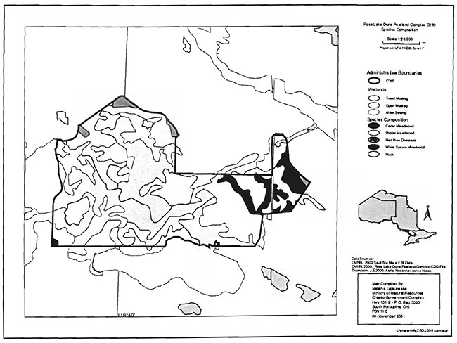
10.1 Map 1: Location of Rose Lake Dune Peatland Complex (C260)
Enlarge Map 1: Location of Rose Lake Dune Peatland Complex (C260)
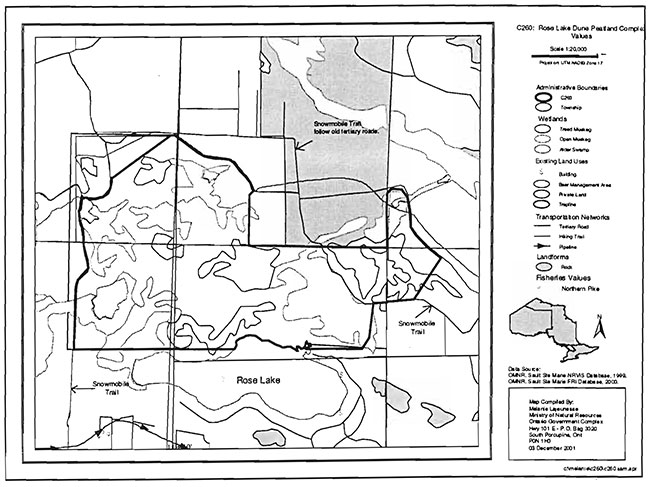
10.2 Map 2: Values Map for Rose Lake Dune Peatland Complex (C260)

Enlarge Map 2: Values Map for Rose Lake Dune Peatland Complex (C260)
10.3 Map 3: Location of Voyageur Trail Within Conservation Reserve
10.4 Map 4: Landforms Map
10.5 Map 5: Species Composition
10.6 Map 6: Snowmobile Trail
11.0 Photos
Photo 1: Peatland touching the northeast shore of Rose Lake.
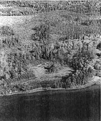
Photo 2: Marsh in northeastern part of conservation reserve.
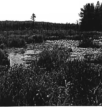
Photo 3: Looking west, near the north end of the conservation reserve.
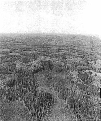
Photo 4: Peatland in southeastern part of the conservation reserve, just north of the cottages on Rose Lake.
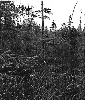
Photo 5: Wetland in northwestern portion of conservation reserve. Standing on ATV trail, looking north.
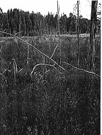
Photo 6: Unmarked ATV trail in northern portion of the conservation reserve.
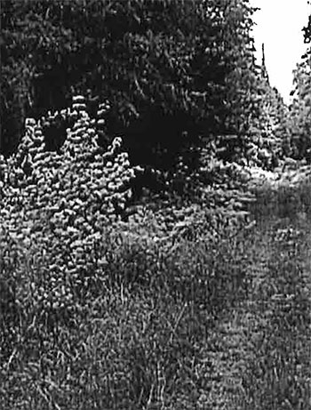
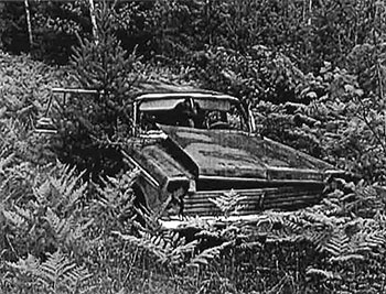
Photo 7: Abandoned car just east of road, inside the west boundary of the conservation reserve.
Appendices
Appendix A: SCI Test of Compatibility
Test of Compatibility
-
Conformity to SCI/RMP- SCI describes values for which an area has been set aside and the range of appropriate uses that will be permitted in the area. SCI may also speak to the acceptability of other 'new' uses currently not occurring in the area.
The first 'test' is: "do proposed new land uses and/or commercial activities conform to the direction of the SCI/RMP for the conservation reserve? Would the new use(s) depart from the spirit of appropriate indicator land uses in the SCI/RMP?"
- Screening Process - proposed uses for the area must be assessed before they are approved. To establish a minimum standard, Northeast Region (NER) recommends that the Screening Process identified in Section 4.2 of A Class EA for Provincial Parks and Conservation Reserves Phase lib: Draft Class EA (subject to approval by MOE) be used to screen projects and options.
- Impact Assessment - the Test of Compatibility from the Conservation Reserve Policy (PL 3.03.05) identifies the classes of values and main concepts that need to be considered in determining the impacts of uses on a specific Conservation Reserve. These include:
The class EA (Table 4.1) presents similar values and concepts under the following considerations:
The above considerations and classes of values are meant to assist planning staff in answering the following questions for any potential use:
- Natural heritage
- Cultural
- Research activities
- Current uses
- Area administration
- Accommodating the use outside the conservation reserve
- Socio-economics
- Area accessibility.
- Natural environment
- Land use, resource management
- Social, cultural and economic
- Aboriginal
- Will the new use impact any values within the conservation reserve?
- If so how?
- To what degree?
- Is it tolerable?
Appendix B: Summary of Permitted Uses
Crown Land Use Atlas - Policy Report
C260
Rose Lake Dune Peatland Complex
Updated: September 25, 2002
Identification:
ID: C260
Area Name: Rose Lake Dune Peatland Complex
Area (ha): 273
Designation: Conservation Reserve (Ontario’s Living Legacy)
District(s): Sault Ste. Marie
Description:
This site contains dune habitats created with &ands from the Kirkwood Delta. The dunes, like the delta, are elevated above current lake levels. The rolling site haa created a slow drainage that now supports peatlands. These indude stands of black spruce surrounded by lichens, blueberry peatlands, thickets, and classic bog habitats. This conservation reserve is in Site District 5E1.
Rose Lake Dune Peatland Complex was regulated as a conservation reserve on April 6, 2001.
Land Use intent:
Management of this area is also governed by the general policies contained in the Land Use Strategy (1999).
Management direction:
Those uses and management activities not listed in the following table are governed by existing conservation reserve policy. Over time the management direction will be elaborated in a Statement of Conservation Interest or Resource Management Plan. Any new uses, and commercial activities associated with conservation reserves, will be considered on a case by case basis, and they must pass a test of compatibility to be acceptable. Compatibility is normally determined through a planning process.
Commercial activities
| Activity | Permitted | Guidelines |
|---|---|---|
| Aggregate Extraction: | No | |
| Bait Fishing Existing: | Yes | Existing use permitted to continue, unless there are significant demonstrated conflicts. |
| Bait Fishing New: | Maybe | New operations can be considered, subject to the "test of compatibility" |
| Commercial Fishing Existing: | Yes | Existing use permitted to continue, unless there are significant demonstrated conflicts. |
| Commercial Fishing New: | Maybe | New operations can be considered, subject to the "test of compatibility". |
| Commercial Fur Harvesting Existing: |
Yes | Existing use permitted to continue, unless there are significant demonstrated conflicts. Existing trap cabins can continue; new cabins are not permitted. |
| Commercial Fdur Harvesting New: |
Maybe | New operations can be considered, subject to the "test of compatibility". |
| Commercial Hydro Development: | No | |
| Commercial Timber Harvest: |
No | |
| Commercial Tourism Existing: | Yes | Existing authorized facilities can continue, unless there are significant demonstrated conflicts. |
| Commercial Tourism New: | Maybe | New tourism facilities can be considered during the planning for an individual reserve. |
| Bear Hunting by Nonresidents (guided) Existing: | Yes | Existing authorized operations permitted to continue. |
| Bear Hunting by Nonresidents (guided) New: | No | New operations not permitted. |
| Outfitting Services Existing: | Yes | Existing authorized operations permitted to continue. |
| Outfitting Services New: | Maybe | New operations can be considered during the planning for an individual reserve. |
| Outpost Camps Existing: | Yes | Existing authorized facilities permitted to continue. |
| Outpost Camps New: | Maybe | New facilities can be considered during the planning for an individual reserve. |
| Resorts/lodges Existing: | Yes | Existing authorized facilities permitted to continue. |
| Resorts/lodges New: | Maybe | New facilities can be considered during the planning for an individual reserve. |
| Energy Transmission and Communications Corridors Existing: | Yes | These facilities should avoid conservation reserve lands wherever possible. |
| Energy Transmission and Communications Corridors New: | No | |
| Food Harvesting (Commercial) Existing: | Maybe | |
| Food Harvesting (Commercial) New: | Maybe | |
| Mineral Exploration and Development: | No | |
| Peat Extraction: | No | |
| Wild Rice Harvesting Existing: | Yes | |
| Wild Rice Harvesting New: | Maybe |
Land and resource management activities
| Activity | Permitted | Guidelines |
|---|---|---|
| Crown Land Disposition Private Use: | Maybe | Sale of lands is not permitted, except for minor dispositions in support of existing uses (e.g. reconstruction of a septic system). Renewals of existing leases and land use permits are permitted. Requests for transfer of tenure will be considered in the context of the Statement of Conservation Interest or Resource Management Plan. |
| Crown Land Disposition Commercial Use: | Maybe | New leases or land use permits permitted for approved activities. Tourism facilities can apply to upgrade tenure from LUP to lease. |
| Fire Suppression: | Yes | Fire suppression policies are similar to adjacent Crown lands, unless alternative fire policies have been developed through a planning process. |
| Fish Habitat Management: | Maybe | |
| Fish Stocking: | Maybe | Existing authorized operations permitted to continue. New operations not permitted. |
| Inventory/disease Supperssion: | Maybe | |
| Inventory/Monitoring: | Yes | |
| Prescribed Burning: | Maybe | |
| Roads (Resource Access) Existing: | Yes | Existing roads can continue to be used. Continued use will include maintenance and may include future upgrading. |
| Roads (Resource Access) New: | Maybe | New roads for resource extraction will not be permitted, with the exception of necessary access to existing forest reserves for mineral exploration and development. |
| Vegetation Management: | Maybe | Conservation Reserves policy indicates that Featured Species Management and Natural Systems Management may be permitted. Vegetation management can be considered in a planning process. |
| Wildlife Population Management: | Maybe |
Science, education and heritage appreciation
| Activity | Permitted | Guidelines |
|---|---|---|
| Collecting: | No | |
| Historical Appreciation: | Yes | |
| Nature Appreciation: | Yes | |
| Photography and Painting: | Yes | |
| Research: | Yes | |
| Wildlife Viewing: | Yes |
Recreation activities and facilities
| Activity | Permitted | Guidelines |
|---|---|---|
| All Terrain Vehicle Use On Trails: | Yes | Existing use permitted to continue where it does not adversely affect the values being protected. |
| All Terrain Vehicle Use Off Trails: | No | ATV use off trails is not permitted except for direct retrieval of game. |
| Campgrounds: | Maybe | |
| Food Gathering: | Yes | |
| Horseback Riding (trail): | Yes | Existing use on trails permitted. |
| Hunting: | Yes | |
| Mountain Bike Use: | Yes | Existing use on trails permitted. |
| Motor Boat Use Commercial: | Yes | |
| Motor Boat Use Private: | Yes | |
| Non-motorized Recreation Travel: | Yes | |
| Private Recreation Camps (Hunt Camps) Existing: | Yes | Existing camps permitted to continue, and may be eligible for enhanced tenure, but not purchase of land. |
| Private Recreation Camps (Hunt Camps) New: | No | |
| Rock Climbing: | Maybe | |
| Snowmobiling On Trails: | Yes | Existing use permitted to continue where it does not adversely affect the values being protected. |
| Snowmobiling Off Trails: | Maybe | Snowmobile use off trails is not permitted, except that snowmobiles may be used for direct retrieval of game. |
| Sport Fishing Trail Development Existing: | Yes | Development of trails for a variety of activities (e.g. hiking, cross-country skiing, cycling, horseback riding, snowmobiling) can be considered as part of planning for an Individual reserve. |
| Sport Fishing Trail Development New: | Maybe |
Note. The policies outlined in this table do not supersede any Aborginal or treaty rights that may esixt, or other legal obligations.
Management of this conservation reserve is carried out within the context of Conservation Reserve policy as amended by the policies for new conservation reserves outlined in the Ontario’s living legacy Land Use Strategy.
Source of direction:
Ontario’s Living Legacy Land Use Strategy (1999)
Conservatitm Reserves Polley (1997)
Blind River Distrid Land Use Guidelines (1983)
Explanation of edits:
Appendix C: Public Consultation Handouts
September 1, 2000
To: Ontario Living Legacy stakeholders
Dear Sir/Madam:
On July 16, 1999, the Ontario Government released the Ontario’s Living Legacy Land Use Strategy, a broad land use approach to the planning and management of much of the Crown lands in central and parts of northern Ontario. A major part of the Ontario’s Living Legacy Land Use Strategy (OMNR 1999) was a government commitment to the biggest expansion of provincial parks and conservation reserves in Ontario’s history. Ontario intends to add 378 new areas to its protected areas system. Ontario’s Living Legacy is a momentous achievement that will be recognized around the world as a significant contribution to sustaining our natural environment. A copy of the Land Use Strategy is available from our office upon request.
In accordance with the recommendations in the Land Use Strategy, the Ministry of Natural Resources is now implementing the process of establishing these 378 new protected areas. The first step in this process is for the Ministry to consult on the boundaries of these areas. In November 1999, Ministry of Natural Resources held boundary consultations on 64 sites across the OLL Planning Area. Eight of these sites were within Sault Ste. Marie District. At this time, Sault Ste. Marie District has prepared 19 more sites for boundary refinement consultation. Adjacent Districts are consulting an additional two sites, which are also partially contained within Sault Ste. Marie District, on. In future years, the remaining recommended protected areas from the Land Use Strategy will be put forward for similar consultations.
As stated in the Land Use Strategy, the boundary refinement process will consider local ecological information and will attempt to establish regulated boundaries along features that can be identified on the ground. The boundary refinement process may result in modest increases or decreases in the sizes of the protected areas. Any existing commitments for the areas, which were considered during the land use planning process, will be considered in defining the final boundary.
Following is a list of the 21 sites in SSM District scheduled for boundary consultation this year. These sites include both provincial parks and conservation reserves. The Land Use Strategy established the Ministry’s intent to add these Crown lands to Ontario’s protected areas system, following the extensive public consultation associated with Ontario’s Living Legacy and the Lands for Life land use planning initiatives between 1997 and 1999. The Ministry is inviting public comment on the proposed boundaries of these protected areas prior to their finalization and ultimate regulation under the Provincial Parks Act or the Public Lands Act.
C227 - Glen Crombie Conservation Reserve
P238 - Mississagi River Provincial Park Additions
C243 - Wagong Lake Forest Conservation Reserve
C244 - Rawhide Lake Conservation Reserve
C246 - Echo River Hardwoods Conservation Reserve
C247 - Byrnes Lake White Birch Conservation Reserve
P2S3 - Goulais River Provincial Park
C256 - Basswood Lake Hemlock Conservation Reserve
C258 - Thessalon River Delta I Rock Lake Red Oak Conservation Reserve
C260 - Rose Lake Dune /Peatland Complex Conservation Reserve
C262 - Stuart Lake Wetland Conservation Reserve
P273 - Algoma Headwaters Provincial Park
P274 - Wenebegon River Provincial Park
P277 - Aubinadong - Nushatogaini Rivers Provincial Park
P278 - Pancake Bay Provincial Park Additions
P282 - Batchawana River Provincial Park
P285 - Sandy Islands Provincial Nature Reserve
C289 - Searchmont South Forest Conservation Reserve
C291 - Goulais River Beach Ridges Conservation Reserve
P292 - Lake Superior Provincial Park Additions
C307 - Ile Parisienne Conservation Reserve
Your name and address have been included within a Ministry mailing list of persons potentially interested in these boundary consultations. The mailing list includes a range of individuals and groups, such as nearby landowners, resource users, persons with other rights or tenure (e.g. land use permit, Mining Act rights), municipalities, and others who may have an interest in the area. Accompanying this letter, you will find background information (factsheets, maps) for the site(s) we have determined to be of interest to you. More detailed maps and information about the proposed boundaries for all 21sites are available from this office, or from the Blind River Area Office, 62 Queen Ave., Blind River.
In the future and subject to the intended regulation of these areas as provincial parks and conservation reserves, Ontario Parks and the Ministry of Natural Resources will undertake a management planning process to determine the long-term management of these protected areas. Depending upon the complexity of issues related to the provincial parks, management planning may take the form of a simple Interim Management Statement or a more detailed Park Management Plan. In the case of planning for conservation reserves, a simple Statement of Conservation Interest or a more detailed Resource Management Plan will result. Please let us know if you would like to be notified when planning begins.
Planning, management and permitted uses within these provincial parks and conservation reserves would be consistent with the commitments of the Ontario’s Living Legacy Land Use Strategy.
The Ministry is collecting comments and information regarding these proposed provincial park and conservation reserve boundary reviews under the authority of the Provincial Parks Act and the Public Lands Act respectively. These comments will assist the Ministry in making decisions and determining further public consultation needs. Comments and opinions will be kept on file and may be included in study documentation that is made available for public review. Under the Freedom of Information and Protection of Privacy Act (1987), personal information will remain confidential unless prior consent is obtained. However, the Ministry may use this information as public input on other resource management surveys or projects. For further information regarding this Act, please contact Paul Glassford, A/Information Management Supervisor, Ministry of Natural Resources, Sault Ste. Marie District ( 705-949-1231).
If you would like to discuss the proposed boundaries and the protection of these areas under the Provincial Parks Act and/or the Public Lands Act, please contact Erin Nixon, District Planner, Ministry of Natural Resources, 64 Church Street, Sault Ste. Marie, Ontario, P6A 3H3; telephone 705-949-1231 ext. 247, fax 705-949-6450, by October 6, 2000. Further information on Ontario’s Living Legacy is available in our office or by visiting the Ministry’s internet website at /page/ministry-natural-resources-and-forestry.
Thank you for your interest.
Yours sincerely,
Dick Hagman
A/District Manager
Sault Ste. Marie District
DH/sw
Attachments-
Provincial Park and/or Conservation Reserve Factsheet(s)
Proposed Site Boundary Map(s)
Key Map
Permitted Uses Table(s) for Provincial Parks and/or Conservation Reserves
On peut obtenir Ia version franc;aise de Ia presente lettre en s'adressant au bureau du MRN le plus proche, a l'adresse ou au numero de telephone ci-dessous.
Qntario’s Living Legacy
Rose Lake Dune Peatland Complex Conservation Reserve (c260)
Fact sheet
September 2000
Background
On July 16, 1999, the Ontario Government released the Ontario’s Living Legacy Land Use Strategy to guide the planning and management of Crown lands in central and parts of northern Ontario. A major part of the Ontario’s Living Legacy Land Use Strategy was a government intent to establish 378 new protected areas. This commitment marks the biggest expansion of provincial parks and conservation reserves in Ontario’s history.
The proposed Rose Lake Dune Peatland Complex Conservation Reserve is part of this significant expansion of Ontario’s protected areas system.
Size and location
The Rose Lake Dune Peatland Complex Conservation Reserve is located along the north shore of Rose Lake, approximately 15 km northeast of the Town of Bruce Mines. The conservation reserve encompasses 273 ha of forested land in Rose Township, and has been recommended as a provincially significant site.
Area highlights
The Rose Lake Dune Peatland Complex Conservation Reserve is located within ecological site district 5E-1, a 25-km deep band of land extending from Sault Ste. Marie to Spanish along the St. Mary’s River and Lake Huron shoreline. This site district is characterized along the coast by lacustrine plains interrupted by small bedrock knolls, and inland by bedrock controlled, till-covered uplands. Natural vegetation communities that develop within this area combine species from both the Great Lakes / St. Lawrence and Boreal forest regions.
The Rose Lake site consists primarily of a sand dune-peatland complex, in which rolling, sand dune ridges, elevated above current lake leveles, have created a slow drainage that now supports peatlands. Some of the sand ridges support regionally significant black spruce-lichen woodland communities, while others support blueberry heath, low shrub thickets, and bracken fern meadows. The peatland basins support classic bog communities including open, low shrub leatherleaf, and few-seeded sedge graminoid communities. A large raised delta sand flat, the Kirkwood Delta, is in close proximity to the conservation reserve.
This conservation reserve contains a diversity of vegetation - landform ecosites. The location provides an excellent example of a landscape characterized by sand dune ridges and organic depressions. The site has hydrological functions as a carbon sink, and contributes to water quality improvement. It is also identified as a nesting area for sandhill cranes.
Land Use intent
Conservation reserves are areas of Crown land sefaside by regulation under the Public Lands Act.
Conservation reserves complement provincial parks in protecting representative natural areas and special landscapes. Most recreational (e.g. hiking, skiing, tourism related uses, nature appreciation) and non-industrial (e.g. fur harvesting, commercial fishing and bait harvesting) activities that have traditionally been enjoyed in the area will continue, provided that these uses do not impact on the natural features needing protection. Hunting and fishing are also permitted within all new conservation reserves recommended through Ontario’s Living Legacy.
Commercial timber harvesting, mining, aggregate extraction and commercial hydroelectric development are prohibited in conservation reserves. Careful mineral exploration may occur in specific new conservation reserves proposed through Ontario’s Living Legacy, in areas that have provincially significant mineral potential. If a portion of a new conservation reserve is to be developed for a mine, it would be removed from the reserve, and appropriate replacement lands would be placed in regulation. Please refer to Table 4 from the Land Use Strategy for a detailed summary of permitted uses in conservation reserves.
Next steps
The Land Use Strategy established the Ministry’s intent to add these Crown lands to Ontario’s protected areas system, following the extensive public consultation associated with the Ontario’s Living Legacy and Lands for Life land use planning initiatives between 1997 and 1999. Prior to the finalization of the boundary of this conservation reserve proposed for regulation under the Public Lands Act, the Ministry is inviting public comment on the proposed boundary from all potentially affected stakeholders and First Nations from September 6 to October 6, 2000.
In the interim, the area has been withdrawn and protected from resource extraction activities such as timber harvesting, hydroelectric development, aggregate extraction and new mineral exploration.
In the future and subject to the intended regulation of the area as a conservation reserve, the Ministry of Natural Resources will prepare a long term management plan for this area. Depending upon the complexity of issues within this conservation reserve, management planning may take the form of a simple Statement of Conservation Interest or a more detailed Resource Management Plan. Please let us know if you would like to be notified when planning begins.
Planning, management and the uses permitted within this conservation reserve will be consistent with the commitments of the Ontario’s Living Legacy Land Use Strategy.
For more information
For further information on the proposed Rose Lake Dune Peatland Complex Conservation Reserve, please contact Erin Nixon, District Planner, Ministry of Natural Resources, Sault Ste. Marie District (705-949-1231 ext. 247). You may also visit the Ministry’s internet website at www.ontarioslivingleqacy.com (link no longer active) for information about Ontario’s Living Legacy.
August 22, 2001
Regulation of Ontario’s Living Legacy Protected Areas in Sault Ste. Marie District
In July 1999, the Ontario Government released the Ontario’s Living Legacy Land Use Strategy, a broad land use approach to the planning and management of Crown lands in central and parts of northern Ontario. A large component of the Ontario’s Living Legacy Land Use Strategy was a government commitment to add 378 new provincial parks and conservation reserves to Ontario’s protected areas system.
In November 1999 and again in September 2000, we provided you with the opportunity to comment on the proposed boundaries for the park and the conservation reserves in Sault Ste. Marie District. I am pleased to inform you that, as of January 2001, the park and fifteen of these conservation reserves have been regulated. The new park and conservation reserves in the District are:
- P285 Sandy Islands Provincial Nature Reserve
- C243 Wagong Lake Forest Conservation Reserve
- C244 Rawhide Lake Conservation Reserve
- C245 Jollineau Conservation Reserve Conservation Reserve
- C246 Echo River Hardwoods Conservation Reserve
- C258 Thessalon River Delta/Rock Lake Red Oak Conservation Reserve
- C260 Rose Lake Dune Peat/and Complex Conservation Reserve
- C262 Stuart Lake Wetland Conservation Reserve
- C263 Garden Lake Forest Conservation Reserve
- C281Tilley Creek West Conservation Reserve
- C284 Wabos North Conservation Reserve
- C286 Wabos South Conservation Reserve
- C289 Searchmont South Forest Conservation Reserve
- C294 O'Connor Conservation Reserve
- C298 Harmony Forest Conservation Reserve
- C307 lie Parisienne Conservation Reserve
Regulation means the park and conservation reserves are now legally mapped and recognized as protected areas of crown land under the jurisdiction of the provincial government. As such, these areas will be protected from industrial activities, including commercial forestry, hydroelectric development, mining, and aggregate and peat extraction. Traditional recreational and resource uses such as hunting, fishing, hiking, canoeing, boating, and fur trapping, will generally be permitted to continue within the conservation reserves. In nature reserve class provincial parks (eg. P285, Sandy Islands), hunting and fur trapping are not permitted; other traditional recreational uses (fishing, hiking, canoeing, boating) may continue.
Ontario Parks staff is responsible for the planning and management of Sandy Islands Provincial Nature Reserve and they will prepare an Interim Management Statement to guide the management of this property. Sault Ste. Marie District is responsible for the management of the conservation reserves and will develop Statements of Conservation Interest (SCI) to guide the management of each new conservation reserve. There will be opportunity for the public to review and comment on draft SCI is for each conservation reserve. Depending upon the complexity of issues related to the sites and their management, more detailed Management Plans may, in due course, be required.
Detailed maps of the regulated boundaries for these new protected areas are available for viewing in the Sault Ste. Marie District office and the Blind River Area office of the Ministry of Natural Resources.
If you have any questions or concerns about the management of Sandy Islands Provincial Nature Reserve, please contact Chris Caldwell, Ontario Parks at the Sault Ste. Marie District Office. Concerns regarding any of the conservation reserves, should be addressed to Sheila Walsh (OLL Resource Planner) also at the Sault Ste. Marie District Office.
Thank you for your interest in Ontario’s Living Legacy.
Yours truly,
Tom Mispei-Beyer
A/District Manager
Sault Ste. Marie District
Telephone: 705-949-1231
Facsimilie: 705-949-6450
E-mail: tom.mispelbeyer@mnr.gov.on.ca
Footnotes
- footnote[1] Back to paragraph Payette level is one of the levels of the Great Lakes when it filled the Huron Basin following the greatest advance of the glacier
- footnote[2] Back to paragraph This Test of Compatibly is taken from both Procedural Guidelines 8- Land Uses -Test of Compatibility PL 3.03.05 and from the Planning Process for Conservation Reserve Statemellt of Conservation Interest and Resource Management Plan Northeast' Region Guidelines Version 2.1 September 17, 2001.