Shallow River Poplar Outwash Conservation Reserve Management Statement
This document provides policy direction for the protection, development and management of the Shallow River Poplar Outwash Conservation Reserve and its resources.
Statement of Conservation Interest
Shallow River Poplar Outwash Conservation Reserve (C1611)
October 2004
Kirkland Lake District
Ministry of Natural Resources
Approval statement
I am pleased to approve this Statement of Conservation Interest (SCI) for the Shallow River Poplar Outwash Conservation Reserve (C1611).
Direction for establishing, planning and managing conservation reserves is defined under the Public Lands Act, the Ontario’s Living Legacy Land Use Strategy, and other applicable policies. The specific direction for managing this Conservation Reserve is in the form of a basic SCI, which defines the area to which the plan applies, provides the purpose for which the Conservation Reserve has been proposed, and outlines the Ministry of Natural Resources' management intent for the protected area. This SCI has been created with input from program specialists within Kirkland Lake District.
This SCI will provide guidance for the management of the Shallow River Poplar Outwash Conservation Reserve and the basis for the ongoing monitoring of activities. More detailed direction at this time is not anticipated. Should significant facility development be considered or complex issues arise requiring additional studies, more defined management direction, or special protection measures, then a more detailed Reserve Management Plan will be prepared with full public consultation.
Public and Aboriginal consultation occurred regarding this site prior to its regulation during the planning for Ontario’s Living Legacy (MNR, 1999). Furthermore, the public was notified during a 30 day period in November, 2004 concerning a draft of this SCI. Comments from the notification period have been considered in the development of this document.
The Shallow River Poplar Outwash Conservation Reserve will be managed under the jurisdiction of the Elk Lake/Matheson Area Supervisor of the Ministry of Natural Resources, Kirkland Lake District.
Plan Author:
Jody Bissett
Land Use Planner
Kirkland Lake District
Signed and approved by:
Corrinne Nelson,
District Manager
Date: March 24, 2005
Signed and approved by:
Rob Galloway,
Regional Director
Date: April 24, 2005
1.0 Introduction
Ontario’s network of natural heritage areas has been established to protect and conserve areas representative of the diversity of the natural regions in the province, including species, habitats, features and ecological systems which comprise that natural diversity. Protected natural heritage areas are a key component in sustainable management of natural resources. They ensure that representative sites within the larger sustainably managed landscape are permanently retained in their natural state.
Natural Heritage areas are considered to be sensitive, requiring protection from incompatible activities if their values are to endure over time. The Ministry of Natural Resources (MNR) has established conservation reserves as a new tool to offer protection for these areas on public lands, while permitting many traditional public land uses to continue. Such uses include the traditional activities of Aboriginal Peoples.
Ontario’s Living Legacy Land Use Strategy (OLL LUS) (MNR, 1999) and the Crown Land Use Policy Atlas set the direction for the administration and management of parks and protected areas on Crown lands within three planning regions; the Boreal West, Boreal East and Great Lakes – St. Lawrence. This strategy’s natural heritage objectives include protection of natural and cultural heritage values and the provision of opportunities for outdoor recreation, heritage appreciation and tourism (MNR, 1999).
Protected areas designated within the OLL LUS have been selected based on their representation of the spectrum of the province’s ecosystems and natural features including both biological and geological features, while minimizing impacts on other land uses. Representation was described using landform and vegetation combinations based on Hill’s (1959) site district concept.
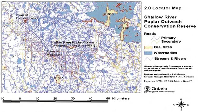
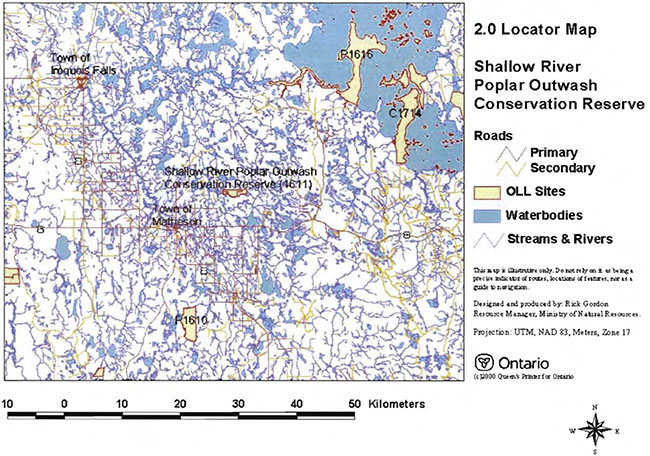
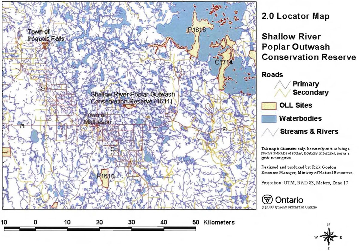
The Shallow River Poplar Outwash Conservation Reserve (C1611) is a 396 ha parcel of Crown land that is situated approximately 45 kilometers northwest of the Town of Kirkland Lake and 10 kilometers northeast of the Town of Matheson. It is found within Beatty Township, in the Kirkland Lake District within the MNR's Northeast Region. The Conservation Reserve is accessible by all-terrain vehicles (ATV's) from the Beatty Township roads off Highway 101 just east of Matheson. Special features within the designated boundaries of this conservation reserve include; important waterfowl staging areas, early wintering areas for moose and a dike structure. This Conservation Reserve will be managed under a Statement of Conservation Interest (SCI).
SCI documents are the minimum level of management direction established for any conservation reserve and generally are brief management plans. This SCI will govern the lands and waters within the regulated boundary of the Shallow River Poplar Outwash Conservation Reserve. However, to ensure MNR protection objectives are being fully met within this Conservation Reserve, management of the surrounding landscape and related activities should consider the site’s objectives and heritage values. In addition, it is the intent of the SCI to create public awareness that will promote responsible stewardship of protected areas and surrounding lands. The MNR will work together with management partners such as Ontario Parks, industry and local governments to pursue and advance sound environmental, economic and social strategies and policies related to the protection of conservation reserves and provincial parks.
The purpose of this SCI is to identify and describe the values of Shallow River Poplar Outwash Conservation Reserve and outline the Ministry’s management intent for the CR. The management direction will protect the site’s natural heritage values and demonstrate its compatibility within the larger sustainable landscape. This direction will comply with land use intent as stated by the OLL Land Use Strategy (MNR, 1999).
Figure 1.0 Shallow River Polar Outwash Conservation Reserve
Enlarge figure 1.0 Shallow River Polar Outwash Conservation Reserve
2.0 Goals and objectives
2.1 Goal of Statement of Conservation Interest
The goal of this SCI is to describe and protect natural heritage values on public lands while permitting compatible land use strategies. This Statement of Conservation Interest is intended to guide the management decisions that will ensure the Shallow River Poplar Outwash Conservation Reserve will meet this goal through both short and long-term objectives.
2.2 Objectives of SCI
2.2.1 Short term objectives
The short-term objectives are to identify the State of Resource in terms of natural heritage values and current land use activities for the Shallow River Poplar Outwash Conservation Reserve. A priority will be placed on the protection of the site’s natural values via specific guidelines, strategies and prescriptions detailed in this plan. Finally, legislated planning requirements will be met; in particular SCI development will occur within three years of regulation.
2.2.2 Long term objectives
The long-term objectives are to establish representative targets (e.g. future forest conditions) and validate the site as a potential scientific benchmark. To ensure protection of natural and cultural heritage features and values, this SCI will establish an evaluation process to address future new uses and commercial activities associated with them (e.g. Test of Compatibility Procedural Guideline B in Conservation Reserve Policy PL 3.03.05, Appendix #4). Finally, this SCI will identify research/client services and marketing strategies associated with the Shallow River Poplar Outwash Conservation Reserve.
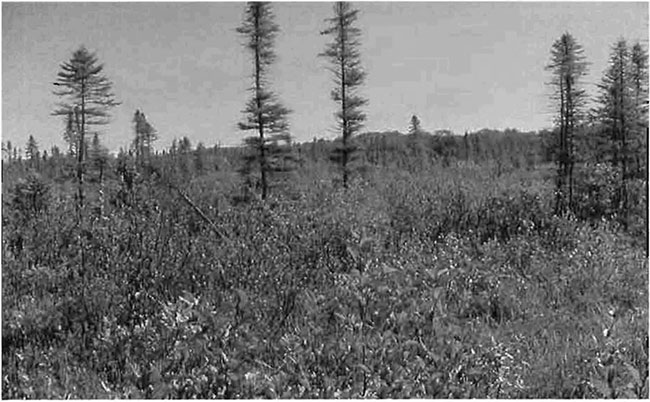
Figure 2.0: Photo of Wetland/Muskeg Site in the Shallow River Poplar Outwash Conservation Reserve.
Photo taken Sept. 5th, 2003 by Rick Gordon.
3.0 Management planning
3.1 Planning area
The planning area for this site will consist of the area within the regulated boundary for the Shallow River Poplar Outwash Conservation Reserve (Locator Map, Appendix #7). This landbase will form the area directly influenced by this SCI. The SCI will recognize the protection of values within the planning area; however, to fully protect values within the Conservation Reserve, the lands beyond the regulated boundary may require additional consideration within larger land use or resource management plans. Nevertheless, any strategies noted within this plan related to the site’s boundary or beyond will need to be presented for consideration within a larger planning context.
3.2 Management planning context
The Shallow River Poplar Outwash Conservation Reserve was first designated as a candidate conservation reserve by MNR in the OLL Proposed Land Use Strategy (MNR March, 1999) and ultimately as conservation reserve in the final OLL Land Use Strategy (MNR, 1999). The Ministry of Natural Resources are in the final stage of regulating this Conservation Reserve. Management and planning direction for this site will follow the OLL LUS (MNR, 1999) and this Statement of Conservation Interest. The area encompassed by this site has been removed from the Timiskaming Forest Alliance Inc. Sustainable Forest License (SFL) landbase.
By regulation this Conservation Reserve cannot be used for commercial forest harvest, mining or hydroelectric power development (MNR, 1999). Existing permitted uses within the CR may continue such as fishing, hunting and trapping. This SCI document and future management of the site will resolve conflicts regarding incompatibility between uses and to ensure that identified values are adequately protected.
This SCI will only address known issues or current proposals with respect to permitted uses or potential economic opportunities brought forward to the District Manager during this planning stage. However, in terms of approving future permitted uses and/or development(s), there are established mechanisms in place to address such proposals. Any future proposals will be reviewed using the Procedural Guideline 8 – Land Uses – Test of Compatibility Public Lands Act Policy PL 3.03.05 (MNR 1997, Appendix #4) or other standard MNR environmental screening processes.
Consideration of proposals pertaining to cultural resources may be screened through 'Conserving a Future for our Past: Archaeology, Land Use Planning & Development in Ontario', Section 3 (MCzCR, 1997), or in processes such as that used by MNR to establish Area of Concern (AOC) descriptions and prescriptions for cultural heritage resources within Forest Management Plans (FMPs).
These planning tools will help refine the review process once the proposal satisfies the direction and intent of the Public Lands Act, associated policies and this SCI.
3.3 Planning process
Once a conservation reserve is passed into regulation, the level of management planning required to fulfill the protection targets must be determined. There are two policy documents involved. A Statement of Conservation Interest (SCI) is the minimal requirement for providing planning direction. A Resource Management Plan (RMP) is written when more complex issues arise, such as when several conflicting demands are placed on the resources. The guidelines for the preparation of these documents are outlined in Procedural Guideline A – Resource Management Planning (Conservation Reserves Procedure PL3.03.05 Public Lands Act). The appropriate plan must be completed within three years of the conservation reserve’s regulation date.
A basic Statement of Conservation Interest is the form of management for this Conservation Reserve. Interested parties from both the private and public sector were consulted during the OLL implementation process, from candidate conservation reserve to regulation. The public was widely consulted during the regulation process and further consultation is not required at this time (Appendix #1). In addition, a public notification of a draft of this SCI document occurred for a period of 30 days beginning in November, 2004 (Appendix #2).
The revised SCI was reviewed by the Kirkland Lake District Manager (DM). Upon approval by the DM the SCI was presented to the Northeast Regional Director (RD) for final approval.
Following RD approval, interested public, user groups and shareholders were notified that the Statement of Conservation Interest for the Shallow River Poplar Outwash Conservation Reserve was approved.
Public consultation will be solicited as part of any future reviews of land use proposals that would require new decisions to be made. In addition, any future proposal and/or any new, significant management direction considered may be published on the Environmental Bill of Rights Registry (EBR).
The SCI is a management document that will provide background information, identify values to be protected and establish management guidelines for use in the administration of the Conservation Reserve.
The implementation of the SCI will be the mandate of the MNR at the District level; however, associations with various partners may be sought to assist in the delivery. This SCI is a working document, and as a result, it may be necessary to make revisions to it from time to time.
4.0 Background information
4.1 Location and site description
4.1.1 Location
The Shallow River Poplar Outwash Conservation Reserve is located approximately 45 km northwest of the Town of Kirkland Lake and 10 km northeast of the Town of Matheson, within Beatty Township in the District of Timiskaming (Locator Map, Appendix #7). The Conservation Reserve was originally in Hills' (1959) site district 3R-3 (Cochrane) but with boundary re–configurations by Grins and Uhlig (2000) the CR is in the 3E-6 (Kirkland Lake) ecodistrict of the 3E (Lake Abitibi) ecoregion.
The following table summarizes the location and provides administrative details of the Shallow River Poplar Outwash Conservation Reserve:
Table 1.0: Location Data and Administrative Details
| Name | Shallow River Poplar Outwash Conservation Reserve |
|---|---|
| Eco. Region – Eco. District (Hills) Eco Region – Eco. District (Crins and Uhlig) |
3E- 3 (Cochrane) 3E- 6 (Kirkland Lake) ecodistrict of the 3E (Lake Abitibi) ecoregion |
| MNR Administrative Region/District Area | Northeast Region/Kirkland Lake District in the Elk Lake/Matheson Area |
| Total Area | 396 ha (includes 140 ha forest reserve) |
| UTM co-ordinates | 801939 W, 483529 N |
| Nearest Town/Municipality | Northwest of Kirkland Lake/Northeast of Matheson |
| Township(s) | Beatty |
| OBM Numbers | 5400538000 |
| Topographical Map Name/Number | Matheson 42A/09 |
| Wildlife Management Unit | 28 |
| Forest Management Unit | Timiskaming Forest |
4.1.2 Site description
4.1.2.1. Physical description
The Shallow River Poplar Outwash Conservation Reserve is a 396 ha parcel of Crown land characterized by stands of spruce, poplar and birch on fresh, moderately sloping terrain, and red and white pine on sand ridges. The landform is typically flat to gently rolling, glacial clay and sand plain with extensive local areas of peatland and wetland. The landscape is broken throughout by glacial features such as moraines, eskers and kame/kettle complexes. The forest climate type is mid-humid, mid-boreal (Poser, 1992). Moderately broken plains of bedrock generally covered with sand and silty sand characterize the eco–district. Several trains of glaciolfluvial sand and gravel also occur (Hills, 1959).
Arial reconnaissance and photo interpretation by Rik Kristjansson (2002), an Ontario Living Legacy Geologist, suggests a surficial geology dominated by bedrock outcrop/bedrock drift complex in the northern section of the CR, glaciolacustrine deposits/holocene:glacionlacustrine deposits in the central section of the CR and organic deposits along the southern border (Map 1a, Appendix #8). These Earth Science landforms are designated as locally significant. Sensitivity level is ranked as low due to the relatively passive land uses anticipated within this Conservation Reserve. The one exception is the organic deposits (i.e. peat land) surrounding Salve Lake. This area is sensitive to recreational activities such as ATV use.
According to the Natural Resources Value Information System the Conservation Reserve is split between bedrock in the south and glaciolacustrine deposits in the north (Map 1b, Appendix #8). However, OLL geologist Rik Kristjansson (2004) believes these landforms are reversed and the provincial landform coverage has a possible shift in the datum layer. Northern Ontario Engineering Geology Terrains Study (NOEGTS) (Lee, 1979) interpreted the site in a similar fashion to Kristjansson. The rest of the area, mainly around Salve Lake, contains discontinuous veneers of organics over glaciolacustrine. Kristjansson states that the CR is predominantly a bedrock terrain with glaciolacustrine deposits of silt and clay in the depressions. For more detailed information see the Earth Science Checksheet (Appendix #9).
The Conservation Reserve is located in the Northern Clay section of the Boreal Forest (Rowe, 1972). It contains widespread surface deposits of water-worked tills and lacustrine materials and a nearly level topography, inheritances from glacial Lake Ojibway. As a result of these landforms, black spruce stands thrive; covering rising uplands as well as lowland flats, alternating in the latter with extensive fens and bogs. With slight changes in relief, forest communities include hardwood or mixedwood stands of trembling aspen, balsam poplar, balsam fir and white spruce. Pure hardwood stands contain no conifer in the canopy layer while mixedwood stands contain a 50:50 split between conifers and hardwoods. Jack pine, along with white birch, is found on dry sites such as outwash deposits, old beaches and eskers. Poorly drained flats, relatively few lakes and clay-banked, rather sluggish streams are characteristic of this Conservation Reserve.
4.2 Administrative description
The legal boundaries of the Shallow River Poplar Outwash Conservation Reserve were filed on ######## with the Office of the Surveyor General, Ministry of Natural Resources in Peterborough, Ontario. This site was passed into regulation ####, 2004.
4.3 History of site
The vegetation and forest cover within this CR provide protective cover and food for large game animals and small land mammals, suggesting this area was historically used for hunting and trapping. These activities continue to the present day with two trapline areas (KL002 & KL007) (Map 3a, Appendix #8), and one Bear Management Area (KL-28-007) within the Conservation Reserve boundaries.
4.4 Inventories
The following table indicates the natural heritage inventories that have occurred or are required in the near future.
Table 2.0: Inventory Data Status
| Type of Inventory | Method | Date | Report Author(s) |
|---|---|---|---|
| Life Science | Aerial Reconnaissance | September 2003 | B. Burkhardt, L. King, S. Longyear; OMNR |
| Earth Science | Aerial Reconnaissance & Aerial Photo Interpretation | October 2004 | R. Kristjansson |
| Recreation | Aerial Reconnaissance | June/September 2003 | R. Gordon; OMNR |
5.0 State of the resource
Representation:
The eco-region which the Shallow River Poplar Outwash Conservation Reserve is in contains extensive black spruce (Sb) stands however, with changes in relief, forest communities of hardwood or mixedwood stands are found. Jack pine and white birch are present on dry sites such as outwash deposits, old beaches and eskers. Poorly drained flats, relatively few lakes and clay-banked, sluggish streams are characteristic of this region.
The Conservation Reserve itself is dominated by Poplar (Po) mixedwoods (46.4% of the total area), rock (13.3%) and brush/alder (10.9%) (Map 2a, Appendix #8). Other forest communities are s10% of total area and include Sb predominant conifer, Sb pure, Po pure and Po hardwood mixed. This total is less than 100% to make up for areas coded other than forest stand. Po mixedwoods are mainly associated with the bedrock surficial geology in the northern half of the Conservation Reserve. Stocking is defined as an expression of the adequacy of tree cover of an area, or how well trees are distributed across the site (OMNR, 2003). Stocking is usually expressed as a percent value, the higher the percent, the more even the distribution pattern. The Po pure stand in this site is barren-and-scattered (i.e. less than 30% stocked). Most of the forest communities were stocked at either 70 or 80% but lower stocking levels occurred in areas associated with bedrock or wetlands (Map 2b, Appendix #8). Tree age ranged from a low of 68 years in the Po mixedwoods to a high of 108 years in the Sb predominant conifer communities (Map 2c, Appendix #8). There is no age data available for the barren-and-scattered pure poplar stand, as stands of this type are not assigned any age during the FRI process. Based on Bridge et al (2000) definition for old growth, there are no old growth stands present in this Conservation Reserve. Due to the Great Fire of 1916 which swept through this area it would be surprising to find large tracts of old growth trees. The small section of Black Spruce, aged 108 years, most likely survived this fire due to the surrounding lake and muskeg wetlands.
The defined Forest Communities found in this CR were re-classified into Standard Forest Units (SFU's), a designation that is common amongst various interest groups in the Northeast Region of Ontario. The five Forest Communities (PO pure, PO hardwood mixed, PO mixedwood, Black Spruce (SB) pure and SB predominant conifer) were re-classified into three SFU's. Poplar (PO1) was the dominant unit found, accounting for 46.0% of the total area. The other two SFU's were black spruce lowland (SB1) (9.6%) and spruce fir mixed MW2) (3.9%) (Map 2d, Appendix #8). The combination of poplar and black spruce lowlands provides suitable early wintering areas for moose (Map 3a, Appendix #8).
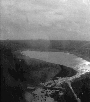
Wetlands (as designated by the Forest Resource Inventory) account for 19.9% of the Conservation Reserve (Map 3b(1), Appendix #8). This number increases to 29.5% if the two black spruce forest communities are considered (Map 3b(2), Appendix #8). A good variety of wetland types are present within the CR, such as floating vegetation mats along the eastern shore of Salve Lake; backed by open bog and poor fen. This open bog extends to the north of Salve Lake with shore fen located along the waters edge. An alder thicket swamp extends from Salve Lake around a conifer swamp (Sb predominant conifer) to Salve Creek upstream from Salve Lake.
In 1988 a dike was built by Ducks Unlimited on Salve Creek, downstream from Salve Lake, to retain and enhance the wetlands in order to improve wildlife habitat and to provide a staging area for migrating waterfowl. On the upstream side, the wetlands consists of meadow marsh, cattail marsh and open water marsh while the other side consists of meadow marsh, cattail marsh and shore fens. Semi-treed and treed bog exists adjacent to a feeder creek to Salve Creek and in an area north of Salve Creek east of Salve Lake (Map 3b, Appendix #8).
Quality of representation:
The quality of the representation or the current characteristics of the natural features found within a conservation reserve are as important as the overall representative features that are being protected. A number of factors are considered when evaluating a site and they include the following criteria: diversity, condition, ecological factors, special features and current land use activities. Each of these factors must be considered when examining a conservation reserve.
a) Diversity:
Diversity is a measure of the site’s life and earth science heterogeneity. It is based on the number and range (variety) of the natural landscape features and landforms for earth science values and the relative richness and evenness of the site’s life science components. Richness refers to the number of cover types or vegetative cover types. For this CR, diversity is estimated to be low. In the analysis conducted by Ontario Parks (2) in 2003, the site contained 13 landform:vegetation (L:V) combinations. It was determined that Ontario Parks did not include the forest reserve portion of the CR in the analysis and the landforms are in the wrong location. However, based on NOEGTS coverage and Rik Kristjansson’s interpretation, it was determined that the CR does have approximately 13 L:V combinations, including the different wetland communities.
The site is dominated by Poplar (PO1) on glaciolacustrine deposits and bedrock complex. This is to be expected, as aspen/poplar were selected (on outwash) to be the dominant vegetation present during the. gap analysis (History map, Appendix 8). With the current configuration of the Conservation Reserve, diversity has increased. Without including the different wetland communities (shore fens, open bog, semi-treed bog, etc.) there would only be eight landform:vegetation combinations present, as opposed to thirteen.
In this Conservation Reserve development stages add little to the diversity. The PO1 communities are all mature while black spruce lowlands (SB1) consisted of immature and mature communities. The bedrock outcrops added some diversity to the site as they have vegetation specific to bedrock that was not captured in the Forest Resource Inventory (FRI).
Evenness is second measure of diversity and refers to the proportion of each cover type. A site that has many cover types of roughly the same size is more diverse than a site with fewer cover types and/or the site has the same number of cover types but one cover type dominates over the others. A site is considered strongly skewed if the top three communities capture more than 60% of the area in the site. Using this definition, the Shallow River Poplar Outwash Conservation Reserve is strongly skewed (70.2% of the CR is PO1, rock and brush/alder), with PO1 the dominant community present. Brush/alder can be broken down to more specific designations such as thicket swamp, shore fens or meadow marsh.
b) Condition:
Condition is the degree of past human and natural disturbance observed or recorded for the site. In the Shallow River Poplar Outwash Conservation Reserve the disturbance is rated as low (i.e. less than 10% of the area is currently under some form of know disturbance).
All of the disturbances are human related, with the largest disturbance being the dike on Salve Creek, downstream from Salve Lake. The dike was installed as part of a Ducks Unlimited project in 1988 and is approximately 300 meters long. The dike itself is composed of soil with a culvert and cage structure in the center. It is wide enough for an all-terrain vehicle to pass over it. A trench from Salve Lake, south of the dike, to downstream of the creek was also created, although it is located outside of the CR. This trench serves as an overflow reservoir as well as providing extra habitat for waterfowl. To access the dike, a trail was etched in the semi-treed/treed bog complex at the west end of the CR.
Besides the dike, numerous hunting stands built into trees were observed during the ground inventory in September of 2003.
c) Ecological factors:
Ecological factors refer to the current design of a conservation reserve as noted by its size, shape and buffering capacity to adjacent land-use activities. Whenever possible, a site’s boundaries should be created to include the greatest diversity of life and earth science features to provide the maximum ecological integrity. It should be ecologically self-contained, bound by natural features and include adequate area to protect the core ecosystems from adjacent land use activities (OMNR, 1992). This CR contains a mixture of biological and vectored boundaries. Vectored boundaries are straight line boundaries that do not follow biological/ecological features on the landscape. The biological boundaries are restricted to Salve Creek and Salve Lake and a small feeder creek into Salve Creek. The southeast corner and west side are adjacent to patent lands; therefore the CR boundaries follow these boundary lines. The northern boundary is vectored as there are no obvious natural boundaries present.
When a conservation reserve is designed, sites which encompass a broad area are preferred over elongated sites. Broad, round sites encompass a larger intact core area, providing more protection from adjacent land use activities than elongated sites. Based on this statement, the Shallow River Poplar Outwash CR is flawed in its design as its length is three times longer in the east-west direction than north-south. Little core area remains on the east and west ends after taking the 200 meter buffer into account (Ontario Parks (1), 2003).
Currently we do not have minimum size standards for conservation reserves under different landscape conditions. However, a minimum size standard of 2000 hectares has been established for natural environmental parks by Ontario Parks (OMNR, 1992). It was determined this minimum standard was necessary to protect representative landscapes as well as allow for low intensity recreational activities. This Conservation Reserve, at 396 ha, falls short of the minimum suggested area suggested by Ontario Parks. With its elongated shape, small size and vectored boundaries, the core area protected by this site is greatly reduced. The level of diversity found within the CR, is also affected due to the small size of the site.
The headwaters of Salve Creek are located just outside the CR on patented land; therefore no protection is available at the source of the headwaters. A section of this creek forms the southern boundary of the CR. As part of headwater wetlands, the creek and lake act as important groundwater recharge areas (OMNR, 1993). Its underlying soils (silt and clay) provide some efficiency in conveying pond water to groundwater. The large bog and floating mat complex on Salve Lake are actively accumulating organic soils in the form of peat and acting as a sink for carbon dioxide. The thicket swamps on Salve Creek, upstream from Salve Lake, also provide some erosion control during spring time flooding.
d) Special features:
The major features that are present within this Conservation Reserve include:
- The dike structure on Salve Creek built by Ducks Unlimited for wetland enhancement
- Headwaters of the Salve Creek in and near the Conservation Reserve
- The important waterfowl staging areas provided by Salve Lake and Salve Creek
- The aspen communities which provide early wintering areas for moose
e) Current land use activities
Hunting, trapping, bird watching, canoeing and ATVing are all activities which take place on the Shallow River Poplar Outwash Conservation Reserve. There are a number of moose stands located throughout the site and in the neighboring area. Moose feeding and wintering areas within the site support a healthy moose population providing optimum hunting opportunities. The surrounding uplands consist of rolling hills with birch, poplar and mixed conifers close to the edges of marshland, providing good habitat for black bear. A hunt guiding outpost is located a couple of kilometers to the southwest of the Conservation Reserve, although it has not been confirmed if they utilize the CR for hunting purposes. Two established trapline areas overlap the Shallow River Poplar Outwash Conservation Reserve (Map 3a, Appendix #8).
Ducks Unlimited (DU) has installed two dykes in order to maintain and support wetland waterfowl breeding and migration. The waterfowl habitat created by these dykes' increases bird watching as well as waterfowl hunting opportunities.
The Ontario Recreational Canoeing Association has identified the Shallow River Poplar Outwash Conservation Reserve as an existing canoeing destination. The river system and connecting Salve Lake provide nature, bird and general wildlife viewing opportunities.
ATVing opportunities within the Conservation Reserve are limited. There is one main trail through the center of the site, providing access to Salve Lake and Salve Creek. The existence of the trail is directly attributed to large game hunting and it is expected that the vast majority of trail use occurs during the moose and deer hunt season. Much of the trail (80%) was under water, running through muskeg and floating bogs, at the time of the ground survey.
There are no official snowmobile trails which access the Conservation Reserve. However, opportunity exists for interested persons to snowmobile through sections of the CR during the winter months.
Summary:
Shallow River Poplar Outwash Conservation Reserve is a protected landform comprised of exposed bedrock as well as marshlands associated with waterways and lakes bordering the site. Based on Kristjansson’s interpretation and NOEGT, the significance has to be re-visited as the site is dominated by glaciolacustrine deposits and bedrock with some organics, not by outwash. The aspen forest communities which are present have not reached the old growth stage, using stage development definitions by Bridge et al (2000). In the analysis conducted by Ontario Parks (2) (2003), the CR is dominated by mixed deciduous forest on glaciolacustrine deposits and dense deciduous forest on bedrock. The deciduous forests would be equivalent to P01 and MW2 using SFU analysis. Although there is a 'shift' in the landform layer, these two landform:vegetation units are present in the CR. Unfortunately, they are not of significance as these units are well represented elsewhere in the ecodistrict. The CR is significant for treed bog on organic deposits and open bog on organic deposits; however the total protected area does not meet the ecodistrict requirement.
Natural heritage representative features
Landform – Vegetation (LV) Type
Table 3.0: Vegetation Types
| Landform | Vegetation |
|---|---|
| Bedrock | Open Muskeg |
| Bedrock | Treed Muskeg |
| Bedrock | Black Spruce (dominant) |
| Bedrock | Brush/Alder |
| Bedrock | Poplar Mixedwoods |
| Bedrock | Poplar (pure) |
| Bedrock | Black Spruce (pure) |
| Glaciolacustrine Deposits | Poplar Mixedwoods |
| Glaciolacustrine Deposits | Poplar Hardwood Mixed |
| Glaciolacustrine Deposits | Black Spruce (pure) |
| Glaciolacustrine Deposits | Brush/Alder |
| Glaciolacustrine Deposits | Treed Muskeg |
| Glaciolacustrine Deposits | Open Muskeg |
Forest Resource Inventory (FRI) data
- Dominant species, wetlands, and depleted areas
- See Forest Species Composition Map (Map 2a, Appendix #8)
5.1 Social/economic interest in area
a) Linkage to local communities:
The Shallow River Poplar Outwash Conservation Reserve is a 396 hectare parcel of Crown land that is situated approximately 45 km northwest of the Town of Kirkland Lake, 10 km northeast of the Town of Matheson and 60 km west of the Ontario/Quebec border. This site is found within Beatty Township in the District of Timiskaming (Locator Map, Appendix #7).
Current uses are related to consumption of fish and wildlife resources, trapping, hunting and ATV-use. Potential recreational activities include hiking and canoeing, bird watching, photography and nature study and in the winter-time, snowmobiling and ice-fishing
b) Heritage estate contributions
The Shallow River Poplar Outwash Conservation Reserve contributes to the province’s parks and protected areas system through its regulation, representation and the long-term management of natural heritage values. By allocating these lands to the parks and protected areas system, the province has ensured a certain level of permanence by distinguishing the site and its values from the broader general use or more extensively managed landscape. In addition, its natural features are, and will continue to be available for present and future generations to enjoy and explore.
c) Aboriginal groups
The site is not located within a First Nation’s area of interest or land claim; however due to the relatively close nature of the Wahgoshig First Nations, they have been invited to participate during the Recreation Inventory and Planning Processes.
d) Mining interests
There are three current mining leases within Shallow River Poplar Outwash Conservation Reserve. L3000726 & L3000723 are held by Canadian Royalties Inc. and L3016570 is held by Big Red Diamond Corporation. These are shown as Forest Reserves, and together account for 140 of the 396 hectares of the CR. Forest Reserves are areas where protection of natural heritage and special landscapes are priorities, but some resource use can take place with appropriate conditions. The intention is that these lands will be added to the Conservation Reserve if a claim or lease is retired through normal processes. On the remaining 256 ha, mining and surface rights have been withdrawn from staking under the Mining Act (RSO 1990 Chapter M.14).
e) Forest and fire management history:
This site has not been affected by recent forest management activities; however an aerial reconnaissance survey showed a significant harvest area to the south of Salve Lake, just outside the Conservation Reserve. This area was harvested by Domtar in June of 1999. A fairly large area is scheduled to be harvested within the next couple of years, just north-east of the Conservation Reserve.
The site has no recent burned areas within its boundary. Past natural disturbances include the Great Fire of 1916 which burned 500,000 acres in and around the town of Matheson.
5.2 Natural Heritage Stewardship
Analysis of the life science targets based on landform:vegetation combinations has shown that the Conservation Reserve contains 13 landform:vegetation (L:V) combinations. This number includes the different wetland communities, without including these communities L:V combinations would be eight. The site is dominated by P01 on glaciolacustrine deposits and P01 on bedrock complex. It is expected that aspen/poplar would be the dominant vegetation as it was selected (on outwash) during the gap analysis (History map, Appendix #8).
Development stages add little to the diversity of this Conservation Reserve. The Poplar communities are all mature, while the black spruce lowlands consist of immature and mature communities. The bedrock outcrops add some diversity to the CR as it supports vegetation which is specific to bedrock that was not captured in the FRI. For this site, the communities are strongly skewed (70.2%) towards P01, rock and brush/alder; a site is considered strongly skewed if the top three communities capture more than 60% of the site in area. Brush/alder can be broken down further to thicket swamps, shore fens and meadow marshes. The majority of the forest communities' fall into the 60-89 year age categories, with no old growth stands present within the Conservation Reserve.
5.3 Fish and wildlife
Salve Lake is approximately 60 hectares in size and is surrounded by a typical bog fringe. This lake supports a small brook trout community but is not suspected to contain a large sport fish population. The 'backcountry' access into the area may dissuade some anglers. Additional research could be done to determine 'fish species and quantities present within the lake to provide a more complete picture of the fishing opportunities in Salve Lake.
Ducks Unlimited installed two dykes in 1988, with the intention of maintaining and improving waterfowl breeding and migration sites. Salve Lake and the associated wetlands and river system, provide excellent waterfowl nesting for the following species; Mallard (Anas platyryhnchos), Blue-winged teal (A. discors), Green-winged teal (A. crecca carol-inesis), Black duck (A. rubripes), America! Wigeon (A. americana), Ring-necked (Aythaya collaris), Wood duck (Aix sponsa) and Canada Goose (Branta canadensis). Salve Lake and its associated waterbodies also provide a staging area for migrating waterfowl. As well as those listed above, Pintail (Anus acuta), Greater Scaup (Aythya marila), Lesser Scaup (A. affinis) and Snow Goose (Anser c. caerulenscens) use the marsh during migration.
In addition to bird life, the Salve Lake water system also supports beaver populations. During the ground inventory assessment in 2003 beaver lodges were observed within the lake and rivers.
Much of the area surrounding the water system is black spruce bog with sparse stunted black spruce, sphagnum moss and lichen growth. These areas are proven to be excellent moose feeding grounds providing for and sustaining a healthy moose population, as the number of moose hunters in the fall can attest to.
The surrounding uplands consist of rolling hills with birch, poplar and mixed conifers close to the edges of marshland, providing good habitat for black bear.
5.4 Cultural Heritage Stewardship
A detailed assessment of cultural resources has not been carried out. However, to date no cultural, historic or archeological features have been discovered within the Shallow River Poplar Outwash Conservation Reserve boundaries.
5.5 Land use/existing development
This Conservation Reserve is situated entirely on Crown Land and is unencumbered by any patented land. It does however overlap 3 mining claims (L3000726, L3000723 & L3016570) which have been designated as Forest Reserves (Land Use Designation 7.2.3). Policies for Forest Reserves are similar to the policies for new CR's, except that mining and related access will be allowed in a Forest Reserve. These areas were initially identified for inclusion in the Conservation Reserve but under detailed examination existing mining leases or claims were discovered. The intention is that these lands will be added to the Conservation Reserve if a claim or lease is retired through normal processes.
Mining and surface rights have been withdrawn from staking within the rest of Shallow River Poplar Outwash Conservation Reserve boundaries under the Mining Act (RSO 1990 Chapter M.14).
5.6 Commercial land use
Present commercial use activities overlapping the site include one bear management area (KL-28-007) and two trap line areas (KL-002, KL-007) (Map 3a, Appendix #8).
5.7 Tourism/recreation use/opportunities
Some of the features within the site associated with possible recreational use include large and small mammals, mixed forests, and aquatic flora and fauna. Existing recreational uses in this site and immediately surrounding the site include trapping, large game hunting, small game hunting, canoeing and possibly fishing. There is also potential for activities such as ATV and snowmobile use, bird watching and nature study.
For a more detailed report and summary of the recreational use and potential, refer to the Recreational Inventory Report (Appendix #3).
5.8 Client services
Currently, visitor services are limited to responding to inquiries regarding access, natural heritage features and boundaries. No formal information or interpretive facilities currently exist within Shallow River Poplar Outwash Conservation Reserve. Other client services include providing clients with maps, fact sheets, and other information gathered on the area, such as the Earth/Life Sciences and Recreational Inventory work.
6.0 Management guidelines
6.1 Management planning strategies
The land use intent outlined in the Ontario Living Legacy Land Use Strategy (MNR, 1999) provides context and direction for land use, resource management, and operational planning activities on Crown Land in the planning area and within OLL site boundaries. Commitments identified in the OLL LUS and current legislation (Policy 3.03.05 PLA) forms the basis for land use within the Shallow River Poplar Outwash Conservation Reserve. Management strategies for these uses must consider the short and long-term objectives for the Conservation Reserve. For up to date information on permitted uses refer to the Crown Land Use Atlas (MNR, 2002) (/page/crown-land-use-policy-atlas) (Appendix #6).
Proposed new uses and development will be reviewed on a case-by-case basis. A Test of Compatibility (Procedural Guideline 8- Land Uses (PL 3.30.05)) must be completed before proposals can be accepted. In all cases, ensuring that the natural values of the Conservation Reserve are not negatively affected by current and future activities will be the priority. Therefore any application for new specific uses will be carefully studied and reviewed.
Forest Reserves
Under the OLL LUS, mining and related access will be allowed in Forest Reserves. Activities that could negatively influence the natural heritage values within the FR and/or the CR, the district will work with the proponent to identify and mitigate potential mining or natural heritage concerns. Mining will not occur in any portion of regulated conservation reserve boundaries.
6.2 "State of the resource" management strategies
The development of this SCI and the long term management and protection of the Shallow River Poplar Outwash Conservation Reserve will be under the direction of the MNR's Kirkland Lake District, Elk Lake Matheson Area Supervisor. The following management strategies have been created to achieve the goal and objectives stated earlier in this management document.
Natural Heritage Stewardship
The management intent for the Shallow River Poplar Outwash Conservation Reserve is to allow for natural ecosystems, processes and features to operate undisturbed with minimal human interference while providing educational, research and recreational activities. Forest ecosystem renewal will only be entertained via a separate vegetation management plan. As part of any future vegetation management plan the site and its Site District will be re-evaluated with respect to their known landform/vegetation features to determine if the past harvested areas could contribute additional landform/vegetation values to the Site District.
In addition, the vegetation management plan will need to determine but not be limited to:
- the restoration ecology objectives (e.g. representation) for the area in context with the Site District
- consider current provincial strategies (e.g. management of white pine)
- consider larger long-term conservation reserve (e.g. recreational objectives) and possibly landscape objectives (e.g. contributions to landscape wildlife objectives)
Fire is recognized as an essential process fundamental to the ecological integrity of conservation reserves. In accordance with existing Conservation Reserve Policy and the Forest Fire Management Strategy for Ontario, forest fire protection will be carried out as on surrounding lands.
However, whenever feasible the MNR fire program will endeavor to use "light hand on the land" techniques, which do not unduly disturb the landscape, in this Conservation Reserve. Examples of 'light hand on the land' techniques may include limiting the use of heavy equipment, utilizing high water bomber drops, non-use of foaming agents and limiting the number of trees felled during the fire response efforts.
Opportunities for prescribed burning to achieve/emulate ecological or resource management objectives may be considered. These management objectives will be developed with public consultation prior to any prescribed burning, and reflected in the document that provides management direction for this conservation reserve. Plans for any prescribed burning will be developed in accordance with the MNR Prescribed Burn Planning Manual, and the Class Environmental Assessment for Provincial Parks and Conservation Reserves (approval pending).
Defining compatible uses, enforcing regulations and monitoring and mitigating issues will serve to protect all earth and life science features. Industrial activities such as commercial timber harvest and new hydro generation will not be permitted within conservation reserves. Permits for fuel-wood will not be issued. New energy transmission, communication and transportation corridors or construction of facilities are not permitted within the boundaries of the Conservation Reserve. Such structures negatively impact the quality of the representative features that require protection. New roads for resource extraction will not be permitted. Other activities that do not pass a Test of Compatibility will be prohibited (MNR Policy 3.03.05, 1997).
The intentional introduction of exotic and/or invasive species will not be permitted. Programs may be developed to control forest insects and diseases where they threaten significant heritage, aesthetic, or economic values. Where control is desirable, it will be directed as narrowly as possible to the specific insect or disease. Biological or non-intrusive solutions should be applied whenever possible.
The collection/removal of vegetation and parts thereof will not be permitted; however, subject to a Test of Compatibility, the Area Supervisor may authorize such activities for purposes of rehabilitating degraded sites within the reserve, collecting seeds for maintaining genetic stock and/or for inventory or research purposes.
The Conservation Reserve will be managed by allowing natural ecosystems, processes, and features to function normally, with minimal human interference.
Fish and wildlife
Fish and wildlife resources will continue to be managed in accordance with specific policies and regulations defined by the Ontario Ministry of Natural Resources under the Fish and Wildlife Conservation Act and the Kirkland Lake District, Elk Lake/Matheson Area Supervisor. If any fish stocking is to be performed in the Shallow River Poplar Outwash Conservation Reserve, final decision lies with the Kirkland Lake District Manager.
Fishing and hunting is expected to continue at the current level of intensity. A planned trail and viewing area development may enhance wildlife viewing activities. Any future trail development must consider the values found within the boundaries of the site, the rationale for developing trails within the site and the availability of current access through the site and surrounding areas. Furthermore, any new trail development will require a Test of Compatibility. Low–lying areas and wetlands should be avoided.
Cultural heritage
When possible, the Ministry of Natural Resources will continue to work with the Ontario Ministry of Culture, Tourism and Recreation in identifying archaeological sites to be protected. As of yet, there has been no archaeological sites found within the Shallow River Poplar Outwash Conservation Reserve. At this time additional field surveys within the Conservation Reserve are not anticipated.
Development, research and education proposals may be considered in accordance with the Test of Compatibility and Conserving a Future for our Past: Archaeology, Land Use Planning & Development in Ontario, Section 3 (MCzCR, 1997).
Land use and development
The sale of lands within the Conservation Reserve is not permitted as per the OLL LUS (MNR, 1999). Existing authorized trails can continue to be used and maintained, unless there are significant demonstrated conflicts. New trails will only be allowed if a Test of Compatibility is passed. Any new trail development will require an amendment to the SCI. The cutting of trees for non-commercial purposes (e.g. fuelwood) is not permitted except as required for approved development activity (e.g. trail, viewing site, etc.).
New roads for resource extraction will not be permitted. Abandoned forest extraction roads will not be actively maintained.
There are no other forms of tenure in the conservation reserve other than legal agreements with registered trapper and bear management area operators. The construction of new trap cabins will not be permitted; however, existing cabins will be allowed to continue (LUS MNR, 1999).
Traditional uses within the Conservation Reserve will continue to be permitted; however, the goal will be to resolve conflicts regarding incompatibility between uses and to ensure that identified values are adequately protected.
Commercial use
All existing commercial resource use activities (i.e. trapping, baitfish harvesting, fishing and wild rice harvesting) are permitted to continue and new uses (with the exception of commercial bear hunting) may be introduced, subject to protection of the conservation reserve’s natural heritage values (i.e. Test of Compatibility).
Commercial bear hunting (within BMA) operations may continue and the transfer of existing licenses is allowed, providing the activity has been licensed/permitted since January 1, 1992. Licenses to provide Bear Hunting Services will not be issued in areas where issuance has not occurred since January 1, 1992.
Existing commercial fur harvesting operations are permitted to continue. New operations may be considered subject to a Test of Compatibility.
Aboriginal interests
Aboriginal and treaty rights will continue to be respected throughout the management of this Conservation Reserve. Any future proposal(s) and or decision(s) that have potential impact(s) on individual aboriginal values and or communities will involve additional consultation with the affected aboriginal groups. The Shallow River Poplar Outwash Conservation Reserve is located in an area where the Wahgoshig First Nation have traditionally hunted, neither the regulation of this conservation reserve nor the approval of this SCI will have bearing on the Wahgoshig traditional land uses.
Tourism/recreation
The earth and life science features and their protection shall be the overall theme for tourism. Small-scale infrastructures for enhancing tourism and recreation (i.e., warm-up shelter) may be considered, providing they pass a Test of Compatibility and other MNR requirements.
Most recreational activities that have traditionally been enjoyed in the area may continue provided they pose no threat to the natural ecosystems and features protected by the Conservation Reserve. These permitted activities include walking, hiking, wildlife viewing, fishing, hunting, snow shoeing, and cross–country skiing.
Snowmobiles and all-terrain vehicles (ATVs) are permitted on existing trails and forest access roads within the Conservation Reserve. Under the OLL LUS (MNR, 1999), all mechanized travel is restricted to existing trails. Off trail vehicle use is permitted for the retrieval of game only.
Existing trails for recreational activities, such as; hiking, snowmobiling, ATV use, cycling, horseback riding and cross-country skiing can continue. To ensure the quality of the representation is maintained, all trails and old forest access roads within the site should be identified via new technologies (i.e. GPS) to ensure a record of these features exists. New trails can be considered through a Test of Compatibility (Appendix #4).
Finally, conflict resolution between recreational uses will be a priority. This will be achieved by adhering to the objectives of this SCI with input from relevant user groups. The level of safety and compatibility between activities will determine permitted uses (i.e. Test of Compatibility).
Client services
Clients indicating their interest in the management planning and future use of this Conservation Reserve will be put on a mailing list and notified of any future planning concerning the site.
Services such as supplying maps, fact sheets and other information will continue. Information may be delivered from different sources; however, MNR will be the lead agency for responding to inquiries regarding access, permitted and restricted activities, values and recreation opportunities. A management agreement may be pursued with an appropriate partner to share responsibilities for information services and the delivery of other aspects of this SCI in the future.
6.3 Specific feature/area/zone management strategies
There are no specific management strategies for the maintenance/protection/ enhancement of selected resources within the Conservation Reserve. Development of such strategies will require an amendment to the SCI.
6.4 Promote Inventory, Monitoring and Assessment Reporting (IMAR), and research
Scientific research by qualified individuals, which contributes to the knowledge of Natural and cultural history, and to environmental and recreational management, will be encouraged.
Additional life science inventory or research may be required to refine values and features. Additional assessment and monitoring of the disturbed areas, including trail and old road locations, within the site should occur prior to any additional management direction being finalized in a vegetation management plan for the area.
Research related to the study of natural processes will be encouraged provided it does not harm the values of the reserve (Procedural Guideline C – Research Activities in CR, Appendix #5). The Elk Lake/Matheson Area Supervisor or District Manager may approve the removal of any natural or cultural specimen by qualified researchers. All materials removed remain the property of the Ministry of Natural Resources. All research programs will require the approval of the Ministry of Natural Resources and will be subject to Ministry policy and other legislation.
New developments such as campsites, privies, trails or developed access points or activities will not be considered until a Test of Compatibility is conducted and the proposal is approved by the Elk Lake/ Matheson Area Supervisor or District Manager. Existing roads can continue to be used, but new roads for resource extraction will not be permitted, with the exception of necessary access for mineral exploration and development. The Test of Compatibility or environmental screening process could include a review of the demand for structures or activities and may require more detailed life or earth science or cultural information and possibly a more detailed management plan.
Approved research activities and facilities will be compatible with the site’s protection objective. Permanent plots or observation stations may be established to which researchers can return over time. Any site that is disturbed will be rehabilitated as closely as possible to its original state.
6.5 Implementation, and plan review strategies
Shallow River Poplar Outwash Conservation Reserve SCI will be reviewed on an ongoing basis and as required.
Implementation of the SCI and management of the reserve are the responsibility of the Elk Lake/Matheson Area Supervisor. Partnerships may be pursued to address management needs.
If changes in management direction are needed at any time, the significance of the changes will be evaluated. Minor changes that do not alter the overall protection objectives may be considered and approved by the District Manager without further public consultation and the plan will be amended accordingly. In assessing major changes, the need for a more detailed Resource Management Plan will first be considered. Where a Resource Management Plan is not considered necessary or feasible, a major amendment to this SCI may be considered with public and aboriginal consultation. The Regional Director must approve major amendments.
6.6 Marketing strategies
Shallow River Poplar Outwash Conservation Reserve will be marketed as a representative natural area having earth and life science values, as well as certain recreational values. Marketing efforts to increase use are not a priority and will be kept to a minimum.
6.7 Boundary identification
There is no stated policy to mark the boundaries of a Conservation Reserve. Local management discretion can be used to determine where boundary marking may be appropriate. In order for restrictions to be enforceable, signs must be placed in accordance with the Trespass to Property Act or subsection 28 (1) of the Public Lands Act to advise against any recreational activities.
Figure 3.0: Salve Lake – Shallow River Poplar Outwash Conservation Reserve.
Photo taken during Aerial Reconnaissance Survey, 2003
7.0 References
Burkhardt, B.C, Lori, King, Sean Longyear. 2004. Natural Heritage Area – Life Science Checksheet.
Burkhardt, B.C. 2003. Aerial Reconnaissance Notes.
Bridge, S., R. Watt, G. Lucking and B. Naylor. 2000. Landscape analysis for forest management planning in boreal northeastern Ontario.
Chamber, B.A., Naylor, B.J., Niepoller, J., Merchant, B., and Uhlig, P. 1997. Field Guide to Forest Ecosystems of Central Ontario.
Crins, W.J. and P.W.C. Uhlig. 2000. Ecoregions of Ontario: Modifications to Angust Hill’s Site Regions and Site Districts – Revisions and Rationale.
Geomatics International. 1994. CCEA Case Studies on Ecoregions Gary Analysis: Proposed Methodology for Determination of Representatives. Report prepared for the Canadian Council on Ecological Areas.
Gordon, R.B. 2003. Ground Reconnaissance Notes.
Hills, G.A. 1959a. A Ready Reference to the Description of the Land of Ontario and its Productivity.
Hills, G.A. 1959b. Hills Mapping.
Kristjansson, R. 2004. Earth Science Planning Summary – Shallow River Poplar Outwash Conservation Area (C1611) and aerial landform/surficial material interpretation.
Lee, Hulbert A. 1979. Northern Ontario Engineering Geology Terrains Study, Data Base Map, Kirkland Lake. Ontario Geological Survey, Map 5027. Scale 1:100 000
Ministry of Citizenship, Culture and Recreation. 1997. Archaeology, Land Use Planning & Development in Ontario: An Education Primer and Comprehensive Guide.
Ontario Ministry of Natural Resources. 2003. Silvicultural Treatment Assessment and Reporting System (STARS): Background and Field Manual.
Ontario Ministry of Natural Resources. 1999. Ontario Living Legacy Land Use Strategy.
Ontario Ministry of Natural Resources. 1993. Ontario Wetland Evaluation System – Northern Manual. NEST Technical Manual TM-001. March 1993.
Ontario Ministry of Natural Resources. 1992. Ontario Provincial Parks: Planning and Management Policies -1992 Update.
Ontario Ministry of Natural Resources. 1983. Kirkland Lake District Land Use Guidelines.
Ontario Ministry of Natural Resources. 1995. Forest Resource Inventory Mapping (Ages Corrected).
Ontario Ministry of Natural Resources. 1997c. Ontario Watershed Mapping.
Ontario Ministry of Natural Resources. Lakes 1:600 000 Mapping.
Ontario Ministry of Natural Resources. MTO Roads 1:600 000 Mapping.
Ontario Ministry of Natural Resources. Patent 1:600 000 Mapping.
Ontario Ministry of Natural Resources. Railway 1:600 000 Mapping.
Ontario Ministry of Natural Resources. Townships 1:600 000 Mapping.
Ontario Ministry of Natural Resources. Transmission Lines 1:600 000 Mapping.
Ontario Parks (1). 2003. Life Science Check Sheet Guidelines – Draft. Internal document. February 2003.
Ontario Parks (2) 2003. Landform Vegetation Representation Summary for site C1602 in Ecodistrict 3E-5. (May 2003). Internal Report
Poser, S. 1992. Report of the status of provincial parks in the site region and districts of Ontario. Ministry of Natural Resources Report.
Rowe, J.S. 1972. Forest Regions of Canada.
Appendix 1: Public consultation summary
SCI public consultation summary (C1611)
| Date Received | Client | Comment | Action Taken | Date of Response |
|---|---|---|---|---|
| 02-Dec – 04 | #1 | Client phoned and requested a copy of the draft SCI for C1611 and C1615 | Brief description of contents of a SCI was given over the phone. Copies of draft SCI's for C1611 & C1615 were sent by mail. | 03-Dec-04 |
| 02-Apr – 03 | #2 | Questions regarding building structures in site | Verbally explained personal structures would not be allowed but if the structure is for community use that it was allowed | 02-Apr-03 |
| 02-Jun – 03 | #3 | Received a letter from the Wahgoshig First Nation stating they have no concerns with the boundaries of the site. | Letter of acknowledgement | 02-Jun-03 |
| 18-Jan – 01 | #4 | Wants notification of final approval of sites, of any changes to trapping policies, is fine with no new trapper’s cabins on the sites. Individual was requesting the information on behalf of the Trappers Council | Client was placed on the mail out list and provided with all policy information regarding the sites | 18-Jan-01 |
| 08-Feb – 01 | #5 | Requested maps and some info regarding all OLL sites, he was speaking on behalf of a snowmobile club. He was asking about trails and development of new trails for the purpose of snowmobiling | He was sent via mail, info on existing and new trails, as well as provided with the strategy and all 26 site maps | 08-Feb-01 |
| 30-Mar – 01 | #6 | Requesting the Ontario Recreational Canoeing Association (ORCA) be pu on mailing list | Letter sent ensuring will be contacted at onset of consultation stage, added to mailing lists | 10-Apr-01 |
| 04-May – 01 | #7 | Requesting information regarding hunting within Wildlife Management Unit 28 as well as an update for Lands for Life | Letter sent responding to and updating client | 04-May-01 |
| 30-Aug – 00 | #8 | Individual felt the OLL ad in the paper was lacking without a map and supplied little information with regards to permitted uses | An explanation of the permitted uses was given verbally and the assurance that the mail out package (he was added to) contained maps and explanations | 30-Aug-00 |
| 05-Sept. – 00 | #9 | Requested on behalf of the Northern Pathfinders ATV Club Inc. to be placed on the mailing list for future information and an opportunity to comment | Added to list | 05-Sept.-00 |
| 08-Sept. – 00 | #10 | Client was concerned that the MNR will not be able to monitor and protect these new proposed protected areas because of the staff shortage | she was sent a package of the 26 sites currently being proposed for OLL including maps and fact sheets | 08-Sept.-00 |
| 03-Oct – 00 | #11 | Local Citizens Committee concerned with deadline, feeling they were not given enough time to read over material and provide a decent response | Clarification as to what was expected of them | 03-Oct-00 |
| 06-Oct – 00 | #12 | Comment from individual from Mining Sector – the recommendations from his own round table in the northeast would have been far preferable. Was happy the commitment to allow mineral exploration in the area | Response sent thanking the individual for input | 11-Oct-00 |
Appendix 2: Public consultation ad
Review of draft Statements of Conservation Interest
C1615 Maisonville Bernhardt Muskeg Maple Moraine
C1611 Shallow River Poplar Outwash
C1628 Trollope Lake Burnt Hill Poplar Spruce
C1600 Mistinikon Lake Uplands
C1634 Dunmore Township Balsam Fir Outwash Conservation Reserves
The Ministry of Natural Resources (MNR) invites you to review the draft statements of conservation interest (SCI) for the Maisonville Bernhardt Muskeg Maple Moraine, Shallow River Poplar Outwash, Trollope Lake Burnt Hill Poplar Spruce, Mistinikon Lake Uplands and Dunmore Township Balsam Fir Outwash Conservation Reserves. Copies of these draft documents will be available for review at the Kirkland Lake District MNR office until December 20, 2004.
The Maisonville Bernhardt Muskeg Maple Moraine Conservation Reserve is situated 10 kilometers northwest of the Town of Kirkland Lake. This conservation reserve is located within the township of Bernhardt and is 128 hectares in size. The Shallow River Poplar Outwash Conservation Reserve is situated 45 kilometers northwest of the Town of Kirkland Lake. This conservation reserve is located within the townships of Beatty and is 396 hectares in size. The Trollope Lake Burnt Hill Poplar Spruce Conservation Reserve can be found 50 kilometers east of the Town of Matheson. This conservation reserve is located within the townships of Frecheville and Stoughton and is 2108 hectares in size. The Dunmore Township Balsam Fir Outwash Conservation Reserve is found 10 kilometers northeast of the Town of Matheson. This conservation reserve is located within Beatty Township and is 396 hectares in size. The Mistinikon Lake Uplands Conservation Reserve is located 10 kilometers west of the town of Matachewan in Doon, Powell, Yarrow and Bannockburn townships. This conservation reserve is 4,330 hectares in size.
The statements of conservation interest identify area values and provide direction on resource management activity and appropriate land uses. As conservation reserves, commercial activities such as forest harvesting, mining and hydroelectric power development are prohibited from occurring within the protected area.
The Ministry of Natural Resources (MNR) is collecting comments and information regarding the draft statements of conservation interest under the authority of the Public Lands Act to assist in making decisions and determining future public consultation needs. Comments and opinions will be kept on file for use during the plan’s operating period and may be included in the study documentation, which is made available for public review.
Under the Freedom of Information and Protection of Privacy Act (1987) personal information will remain confidential unless prior consent is obtained. However, this information may be used by the Ministry of Natural Resources to seek public input on the other resource management surveys and projects. For further information on this Act, please contact Shaun Walker at 705-568-3231.
If you would like additional information or would like to supply background information or viewpoints to be considered by the planning team, please contact:
Jessy Malone or Jody Bissett
Land Use Planners
Ministry of Natural Resources
Kirkland Lake District
P.O. Box 910, 10 Government Road East
Kirkland Lake, ON
P2N 3K4
Tel: 705-568-3253
Fax: 705-568-3200
Comments will be accepted until December 20, 2004
Renseignement en francais: 705-568-3222
Appendix 3: Recreational Inventory Checksheet
Shallow River Poplar Outwash Conservation Reserve C1611
Shallow River Poplar Outwash Inventory Report – Version 3.0
A Natural Heritage Area in Ontario’s Living Legacy
Land Use Strategy
Prepared for: Ontario Ministry of Natural Resources, Kirkland Lake District
Prepared by:
Rick Gordon
Resource Manager
Ministry of Natural Resources
Kirkland Lake District
Site Visits: June 12 & Sept 05 and 22, 2003
1.0 Introduction
The Shallow River Poplar Outwash Conservation Reserve is located approximately 45 km northwest of the Town of Kirkland Lake and 10 km northeast of the Town of Matheson (2.0 Locator Map) and consists of approximately 396 hectares of land. This site is found within Beatty Township in the District of Timiskaming. Much of the site can be described as moderately broken outwash covered by old growth poplar/aspen stands located near one of the headwaters of Shallow River and Salve Creek. Parts of the site contain exposed bedrock, a black spruce stand and marshlands associated with waterways and lakes bordering the site. Mixed forest and sparse forest associated with wetlands occur.
The sites natural heritage values were recognized in 1999, when the area was designated as a conservation reserve in Ontario’s Living Legacy Land Use Strategy (LUS). The Crown Land within the Area of Natural and Scientific Interest (ANSI) boundary was incorporated into the Shallow River Poplar Outwash Conservation Reserve. Conservation reserves are designed to complement provincial parks in protecting representative natural areas and special landscapes. As outlined within the LUS, most recreational and non-industrial activities that have been traditionally enjoyed in the area will continue, provided that they do not impact upon the natural features needing protection.
Conservation reserves identified within the LUS were given interim protection in 1999 and the intention is to have all of the sites formally regulated under the Public Lands Act over the next few years. The process to regulate the Shallow River Poplar Outwash Conservation Reserve is currently underway, and regulation is expected in 2004. As the conservation reserve falls within the boundaries of Kirkland Lake district, they will take the lead role in the regulation process.
In addition to the regulation process, a number of inventories, including ground and air Recreational Inventory Reports are being conducted in the Living Legacy sites. Recreation inventories are particularly important to the OLL planning process, as one of the major objectives of the LUS was to ensure that a broad range of natural resource-based recreation opportunities are provided for. As a result the Ontario’s Living Legacy Guidelines for Recreational Inventory Reports were developed. Under these guidelines the Shallow River Poplar Outwash Conservation Reserve recreation inventory report follows four objectives to identify:
- landforms and features, which are or may be used for recreation
- Identify the range of settings that the protected area is able to provide. A variety of settings that range from urban to wilderness will be considered
- Identify all known existing and potential recreation activities
- Identify all the means by which the protected area can be accessed.
The Shallow River Poplar Outwash Recreation Inventory Report was influenced by all four of the basic objectives. The collection of such information will help guide future planning for Ontario’s protected areas, including the Shallow River Poplar Outwash Conservation Reserve. Ontario’s Living Legacy Guidelines for Recreation Inventory Report – Version 3 were followed to prepare this report.
Map: Locator Map for Shallow River Poplar Outwash Conservation Reserve
Enlarge Locator Map for Shallow River Poplar Outwash Conservation Reserve
3.0 Description of Shallow River Poplar Outwash Conservation Reserve (C 1611)
3.1 General setting
The Shallow River Poplar Outwash Conservation Reserve is composed of 396 Ha of Crown land and is found within Beatty Township in the District of Timiskaming. The conservation reserve includes a section of Salve creek and Salve Lake as its eastern and southern boundaries. The nearest town is Matheson a small residential area with churches, a public school, medical facility and a population of approximately 1000. Basic supplies can be purchased along the Highway 11 corridor. The Town of Kirkland Lake with a population of approximately 10,000 is located 45 km southwest of the conservation reserve. The Town of Kirkland Lake has most commonly found shopping, restaurant, recreation and entertainment facilities.
A number of protected areas are found within 30 km of the site (2.0 Locator Map). These include two newly and soon to be regulated Provincial parks and one soon to be regulated conservation reserves: Wildgoose Outwash Deposit Nature Reserve Provincial Park (P1610), Abitibi De Troyes Historic Provincial Park (P1616) and MacDougall Point Peninsula Conservation Reserve (C1714).
The Kirkland Lake District Office is the closest Ministry of Natural Resources Office to the site and the Highway 11 corridor. Administration of the site will be coordinated under the direction of the MNR's Kirkland Lake District, Elk Lake Matheson Area Supervisor.
3.2 Cultural values
Little is known about the cultural values of the conservation reserve. The cultural values GIS layer shows no indication of cultural values within the site.
3.3 Life science values
To date the life sciences features of the Shallow River Poplar Outwash Conservation Reserve have not been well documented. The need for more detailed inventories has been identified and, at the time of writing, a Life Sciences Check Sheet for the site was being prepared.
3.4 Earth science values
To date the earth science features of the Shallow River Poplar Outwash Conservation Reserve has not been well documented. The need for more detailed inventories has been identified and, at the time of writing, an Earth Science Check Sheet for the site was being prepared.
4.0 Methodology
The information that was gathered in this recreation inventory represents two different research approaches, as both primary and secondary sources were used throughout the study. Primary research consisted of field visits and a series of discussions with local residence and seasonal visitors, Conservation Officers and District Staff, while the consultation of internal documents and published reports was considered to be secondary research (Table 1). The original intent was to use secondary sources as the background information that would guide subsequent field visits, which meant that secondary research was to be conducted prior to any field visits. However due to the short duration of the field season, this approach was not always possible and/or feasible. Instead, primary and secondary sources were often utilized concurrently.
Table 1: Summary of Information Sources
| Primary Research | Secondary Research |
|---|---|
|
|
|
|
|
|
|
|
|
|
|
|
|
The two ground visits were each a day in length and covered ATV trails and game trails within the site boundaries. During all visits, notes were made, digital photographs were taken of important features, and trails and important features co-ordinates were recorded using handheld GPS units. The trails and features were later downloaded and incorporated within GIS produced maps (Appendix A).
The information gathered during the site visits (Appendix D) was then combined with that from the secondary sources to complete the recreational checklist (Appendix 8). The checklist was completed in accordance with the Ontario’s Living Legacy Guidelines for Recreational Inventory Reports – version 3. All collected data regarding the Shallow River Poplar Outwash site was documented and incorporated into GIS maps of the site.
5.0 Recreation features
Recreation features are biophysical or cultural attributes that may be able to support recreational activity. A total of eight features were recorded and ranked according to their recreational value and importance on the recreational checklist and Microsoft Access database form (Appendix 8). Features were selected from a list of known recreation features included in the Ontario’s Living Legacy Guidelines for Recreational Inventory Reports. Each feature listed also has a corresponding code, and is classified under a specific category. The following eight sections provide more detail on each of the features and are organized by their rankings, and then listed by feature, feature code and feature category.
5.1 Land mammals, large (W03) – wildlife
Through site visits and observation of vegetation, forest cover, animal tracks and droppings it is fair to say that the expected large game animals moose (A. americanus), and black bear (Ursus americanus) of the region can be found within the conservation reserves boundaries. The entire site is also part of a Bear Management Area and the presence of a local hunting outfitter suggests the area is quite popular for bear hunting. The main ATV trail that runs through the center of the site has numerous (10+) moose stands along its length. GIS layers of the area also confirm the majority of the site is used as moose wintering area with several moose feed areas within the site.
5.2 Land mammals, small (W02) – wildlife
During ground inventory work evidence of a number of small land mammals was prevalent throughout the site. Observation of vegetation, forest cover, animal tracks and droppings suggest the following small animals reside within the conservation reserve: marten (M. martes), fox (V. fulvus), fisher (Mustela canadensis), beaver (Castor canadensis), mink (Putorius lutreola), otter (L. canadensis), muskrat (Fiber zibethicus) and weasel (Mustela). Other small wildlife that is found within the site region is woodcock (Philohela minor), grouse (Bonasa umbellus), heron (Ardea cinerea), bittern (Botaurus stellaris), and kingfisher (Ceryle alcyon).
5.3 Lake, mid size (41-200 ha), (M03) – waterbodies
Salve Lake is the primary waterbody within the site (M03). Salve Lake has had extensive Ducks Unlimited (DU) research and is currently one of their projects. Two DU dykes have been installed to maintain and support the wetland for waterfowl breeding and migration. The upper Salve Lake DU cell consists of approximately 74 Ha’s of lake and riverine wetland. Salve Lake is approximately 60 hectares in size and is surrounded by a bog typical fringe. A floating organic mat located at the east end of the lake averages 0.6 meters in depth. The dominant types of vegetation in this area are; sedge (Carex spp.), leatherleaf (Chamaedaphne calytulate), larch (Larix laricina), willow (Salix spp.), cattail (Typha spp.) blue-joint (Calamagrostis sp.) and tag elder (Alnus sp.). There are lesser amounts of sphagnum moss and iris (Iris spp.). The soils consist of deep, poorly decomposed organics over silt clay. The large open water zone (Salve Lake) averages 2.0 meters of water. It is nearly void of emergents, with only a small amount of remnant hard stem bulrush (Scirpus actus) and burreed (Spargsnium fluctuans) present. Submergent vegetative growth is abundant with coontail (Ceratophyllum demersum), bladderwort (Uitricularia spp.), pondweeds (Pontomageton spp.) and yellow water lily (Nuphar sp.) the dominant species. The soils of this zone consist of a deep hydromorliphic limnic gel over silty clay.
Site C1611 Aerial Photo Flown September 22, 2003
Photo by Jennifer Telford
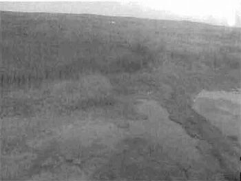
Wetlands in the southern section of the site. Note the Ducks Unlimited water control measure and waterfowl habitat.
5.4 Organic (e.g. bog, fen swamp or marsh), (J05) – landform, surface material
Much of the area surrounding the water systems can be described as black spruce bog with sparse stunted black spruce and sphagnum moss and lichen growth. These areas are shown as proven Moose feeding grounds. With the nearby moose wintering areas (Appendix A) the Shallow River Poplar Outwash Conservation Reserve bogs provide for and sustains a healthy moose population, as the number of moose hunters in the fall can attest.
Site C1611 Aerial Photo Flown September 22, 2003
Photo by Jennifer Telford
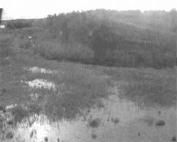
Wetlands associated with the Salve Creek and Salve lake Water bodies, a result of Ducks Unlimited initiatives to create waterfowl habitat.
5.5 Mixed coniferous/deciduous (E05) – Vegetation features
Much of the site can be described as moderately broken outwash covered by old growth poplar/aspen stands located over 90% of the entire site. Several locations within the site contain exposed bedrock or bedrock with sparse covering of brush and alder. Immediately north of Salve Lake is a predominately old growth stand of black spruce. Another pocket of mainly black spruce can be found in the North West corner of the site. Marshlands associated with waterways and lakes border the site. Mixed forest and sparse forest associated with wetlands occur throughout.
Site C1611 Ground Inventory September 05, 2003
Photo by Rick Gordon
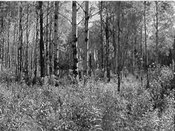
Mixed deciduous/conifer forest north of Salve Lake. This open area was created in association with a nearby moose stand.
5.6 Small River (M06) – Waterbodies
The upper Salve Lake DU cell consists of approximately 74 Ha’s of lake and riverine wetland. The lower DU cell is a dyked off portion of the riverine wetland, consisting of approximately 13 Ha’s. The riverine type wetland consists of a stream approximately 1.5 meters wide exiting from the lake surrounded by a good quality flood plain. Sedges (Carex spp.) and blue-joint (Calamogrostis sp.) are the dominant vegetative species. Other vegetation includes cattail, willow, alder, and remnant hardstem bulrush. Pondweeds and duckweed (lemna sp.) are found in minor quantities in the flood area. The soils consist of good quality humic clays over silty clays.
Site C1611 Aerial Photo Flown September 22, 2003
Photo by Jennifer Telford
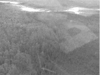
Site C1611 Ground Inventory September 05, 2003
Photo by Rick Gordon
Salve River with second Ducks Unlimited water control structure, mixed deciduous forest and view of black spruce bog.
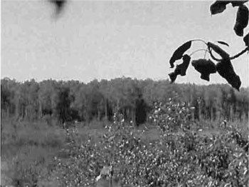
Picture of Salve River taken from Moose Stand north of the river.
5.7 Existing canoe route CT06) – trails or routes
The Ontario Recreational Canoeing Association has identified the Shallow River Poplar Outwash Conservation Reserve as an existing canoeing destination. We have no recorded data that details the number of canoeing enthusiast that may use this river system. During the two ground visits and the arial reconnaissance no canoeists where sighted.
5.8 Existing trail (T08)- trails and routes
The Shallow River Poplar Outwash Conservation Reserve is able to provide limited ATV access. While conducting ground recreation inventory the existing ATV trail was utilized to provide access to the center of the site. ATV trail location data was recorded during the recreation inventory by means of a handheld GPS unit (Appendix A). The condition of the bike trail is poor with 80% of the trail traveling through water/bog to depths of 3 feet. Considering the number of moose stands (10+, map#) along the length of the trail it is probable that the trail is only utilized during the fall for hunting purposes. There are two branch trails off the main trail that access Salve Lake and Salve Creek, could provide canoeing or fishing opportunities.
6.0 Recreational activities
The recreation activities are closely related to the recreation features, although there is not necessarily a direct correlation, as one feature may have the potential to support a wide variety of recreational activities. During the recreational inventory, seven activities were recorded and ranked on the Recreation Inventory Checklist (Appendix B). Activities were selected from a list of known recreational activities included in the Ontario’s Living Legacy Guidelines for Recreation Resource Inventory – Version 3. Each activity listed also has a corresponding code, and is classified under a specific category. Existing activities were differentiated from potential activities by using a capital letter in their activity code. The following seven sections provide more details on each of the features and are organized by their rankings, and listed by activity, activity code and activity category.
6.1 Game, large mammal H01 – hunting and trapping
The number of moose stands located throughout the site and in the surrounding area would suggest that the conservation reserve is part of a traditionally used hunting area. Moose feeding and wintering areas within the site and surrounding area support the existence of a healthy moose population for the sport of hunting. The surrounding uplands consist of rolling hills with birch, poplar and mixed conifers close to the edges of the marsh, good habitat for black bear. A Hunting Guiding Outpost is located a couple of kilometers to the south west of the site, although it is not known/confirmed if they utilize the reserve location for hunting purposes. Ground inventory work shows the existence of berries and vegetation as well as bear sign and scat.
Site C1611 Ground Inventory September 05, 2003
Photo by Rick Gordon
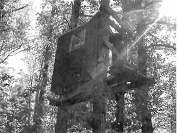
One of many moose stands located along the ATV trail running through the center of the site north of Salve lake.
6.2 Trapping (H06) – hunting and trapping
Two established and active traplines (Appendix D) overlap the Shallow River Poplar Outwash Conservation Reserve. A licenced trappers Cabin is located a few kilometers to the east of the reserve. Many small mammal tracks and droppings were observed during site visits as well as beaver houses observed within the lake and river system.
6.3 Waterfowl (H05) – hunting and trapping
Salve Lake has had extensive Ducks Unlimited (DU) research and is currently one of their projects. Two DU dykes have been installed to maintain and support the wetland for waterfowl breeding and migration. Salve Lake, the associated wetlands and river system provide excellent waterfowl nesting for the following species Mallard (Anas platyryhnchos), Blue–winged teal (A. discors), Green-winged teal (A. crecca carol-inesis), Black duck (A. rubripes), Americal Wigeon (A americana), Ring-necked (Aythaya collaris), Wood duck (Aix sponsa) and Canada Goose (Branta canadensis).
The Salve lake waterbodies also provide a staging area for migrating waterfowl. As well as those listed above, Pintail (Anus acuta), Greater Scaup (Aythya marila), Lesser Scaup (A. affinis) and Snow Goose (Anser c. caerulenscens) will use the marsh during migration.
6.4 Bird watching q10 – viewing
It is not known at this time if bird or nature viewing takes place at this site. With the varied landscapes within the site (fields to the west, black spruce bogs throughout, uplands consisting of rolling hills with birch, poplar and mixed conifers close to the edges of the marsh, and marshlands next to the waterbodies) there are a variety of waterfowl, upland and song birds that exist within the site.
6.5 Upland birds H04- hunting and trapping
The surrounding uplands consist of rolling hills with birch, poplar and mixed conifers, this provides cover and feed for many species of upland birds including the following game birds: Ruffed (Bonasa umbellus) and spruce grouse (Canachites canadensis), wood cock (Philohela minor), snipe (C. gallinago). The area is heavily hunted by large game hunters, who often hunt small game while looking for large game.
6.6 Canoeing B02 -water sports
We have received notice from the Ontario Recreational Canoeing Association which has identified the Shallow River Poplar Outwash Conservation Reserve as an existing canoeing destination. The river system and connecting Salve Lake waterbody provide nature, bird and general wildlife viewing opportunities as well as photography or painting locals.
6.7 ATV (T01) – Travelling
ATV opportunities within the Shallow River Poplar Outwash Conservation Reserve are limited. There is one main ATV trail through the center of the site with access to Salve Lake and Salve Creek. The existence of the ATV trail can be directly attributed to large game hunting and it is expected that the fall is the only time the trail is in use. Much of the trail (80%) is under water and runs through muskeg/floating bog that can reach depths of three feet.
7.0 Recreation factors
The recreational factors provide a context for the information collected during the recreational inventory, as they are meant to provide some insight on how the site will contribute to outdoor recreation at the regional level.
7.1 Feature significance:
Feature significance for the conservation reserve, which is the composite measure of feature scarcity and uniqueness, activity attraction capability, scenic attractiveness, and geographic significance, was rated as low. This designation resulted from the fact that no factors had a rating above moderate with most falling in the low range.
An evaluation of the recreation features determined that none of them could be considered scarce. We here in Northern Ontario are blessed with an abundance of great fishing lakes, scenic forest settings, bogs and streams and marshes for waterfowl migration and feeding, large game hunting areas and although there is ORCA interest in canoeing there are much more attractive canoe routes.
Again, with the abundance of all the above mentioned resources and activities and features there was not one unique feature that stands out within the boundaries of this conservation reserve.
The similarity between the site and the rest of the region also influenced the scenic attractiveness and geographic significance ratings, as these were also ranked as low. Although the site exhibits habitat diversity, it is unlikely it will see many more visitors than any other Crown land and protected areas located within the region. The area will likely continue to be utilized by hunters and local recreation seekers looking for relatively solitary recreational experiences (i.e. canoeists).
The Shallow River Poplar Outwash Conservation Reserve’s activity attraction capability was seen as moderate. The conservation reserve’s size when compared to population density of the surrounding area suggests above average use during the hunting seasons. These hunter numbers coupled with the Ontario Recreational Canoe Associations interest bumped the activity attraction rating from low to moderate.
7.2 Feature sensitivity to recreation use:
The feature found to be the most sensitive to recreational use in the Shallow River Poplar Outwash Conservation Reserve was the Organic wetland areas surrounding the waterbody systems, with a rating of high. This designation was selected due to the fragile nature of the wetland culture and its dependability upon constant water depths provided by the existence of the two Ducks Unlimited dykes systems that were installed to maintain and support the wetland for waterfowl breeding and migration. Also the existence of an ATV trail that runs through and provides access to the sensitive wetland areas within the site and the knowledge that these vehicles can be quite intrusive and destructive to natural environments if not operated with care and respect for the environment.
7.3 Feature sensitivity to resource development:
The feature sensitivity to resource development within the Shallow River Poplar Outwash Conservation Reserve was ranked as very high. This is due to the existing dyke system and the attempts to create a consistent waterfowl habitat for the breeding and migration of waterfowl. Any resource development that could potentially affect the level of the water or contribute to the pollution of this water system would be viewed as the highest risk to the water system feature of the reserve.
7.4 Cultural/historic and archeological features:
To date no cultural, historic or archeological features have been discovered within the Shallow River Poplar Outwash Conservation Reserve boundaries. Areas of high cultural, historic or archeological significance are identified within our mapping layers and no areas of significance are shown to overlap this site.
8.0 Recommendations
Upon completion of this first phase of the recreational inventory, a series of recommendations were made. The recommendations, which were grouped into several broad categories, are as follows.
8.1 Additional research
- Field visits should be made during the winter months to confirm and document other activities, such as snowmobiling and ice fishing
- Determination of existence of further access trails leading into the site from forest harvest operations to the south of Salve Lake
- The environmental impact of recreational and resource development on the area’s more sensitive features needs to be monitored on an on-going basis
- Further studies of the fish quantities and types could be undertaken, and if feasible, fish stocking of the lake or fish habitat enhancements conducted
8.2 Future management
- Some of the moose stands along the ATV trail are beginning to fall into disrepair and may soon be abandoned. Some effort should be made to find the owners of these stands and have the debris removed. If no one can be found to remove the old stands and debris a possible Ontario Rangers project may be considered
- Care should be taken to ensure that all District staff is given access to the information contained within this report and that NRVIS layers are periodically updated to reflect any new information
References
Gordon, R. 2003. Shallow River Poplar Outwash Recreation Inventory Checklist Recreation Inventory Access Database.
Mulrooney D. 2001, Ontario’s Living Legacy Guidelines for Recreation Resource Assessment Version 3 – May 2002, Prepared for Ontario Parks, Planning and Research Section, 30 pages.
Ontario Ministry of Natural Resources, Shallow River Poplar Outwash Conservation Reserve (1611) Factsheet, September, 2000.
Ontario Ministry of Natural Resources, 1999. Ontario’s Living Legacy – Land Use Strategy, July, 1999.
Ontario Ministry of Natural Resources, Kirkland Lake District, Land Use Guidelines, 1983.
Kendra Couling & F.J. (Rik) Kristjansson, 2003. Life and Earth Science information during Shallow River Poplar Outwash Conservation Reserve (1611) Aerial Flight September 22, 2003.
Aldred, Stan. 2003. Local resident who provided information concerning land use and fishing in Salve Lake and Creek.
Ministry of Northern Development and Mines, Claimaps Website, 2003.
Web Site, 2004, http://www.myccr.com/canoedb/routeDetails.php?routeid
Map: Shallow River Poplar Outwash Conservation Reserve
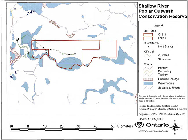
Enlarge Map: Shallow River Poplar Outwash Conservation Reserve
Map: Wildlife Areas in and around the Conservation Reserve
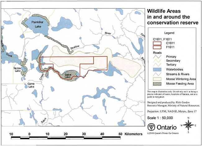
Enlarge Map: Wildlife Areas in and around the Conservation Reserve
Map: Wildlife Management Area’s overlaying the Conservation Reserve
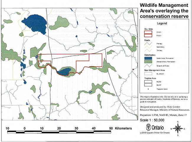
Enlarge Wildlife Management Area’s map overlaying the Conservation Reserve
Appendix 4: Procedural Guideline B – Land Uses – Test of Compatibility (PL Procedure 3.03.05)
Procedural Guideline B – Land Uses -Test of Compatibility (PL Procedure 3.03.05)
The Conservation Reserve policy provides broad direction with regard to the permitted uses. The policy provides only an indication of the variety of uses that will be considered acceptable in Conservation Reserves. The only caution is that "any new uses, and commercial activities associated with them, will be considered on a case by case basis and, they must pass a test of compatibility to be acceptable."
What does a "test of compatibility" mean? An examination of this must start from the premise of why an area is set aside -specifically, its representative natural heritage values. Criteria are then identified to guide compatibility considerations. These criteria apply to the long-term acceptability of both existing uses and new uses.
-
Conformity to SCI/RMP: SCI describe values for which an area has been set aside and the range of appropriate uses that will be permitted in the area. SCI may also speak to the acceptability of other 'new' uses currently not occurring in the area.
The first 'test' is: "do proposed new land uses and/or commercial activities conform to the direction of the SCI/RMP for the conservation reserve? Would the new use(s) depart from the spirit of appropriate indicator land uses in the SCI/RMP?"
- Impact Assessment: If the proposed use(s) pass test 1 it is important to determine their impact on the area before they are approved. This should include the following:
- Impact on natural heritage values: "will the new use(s) impact any natural values in the area? If so how and to what degree? Is it tolerable?"
- Impact on cultural values: "will the new use(s) impact an historical or archaeological values in the area?"
- Impact on research activities: "will the new use(s) affect research activities in the area?"
- Impact on current uses: "will the new use(s) have any negative impact on the array of current uses?"
- Impact on area administration: "will the new use(s) increase administrative costs and/or complexity?" (For example, the cost of area monitoring, security and enforcement).
- Impact on accommodating the use outside the conservation reserve: "Could the use(s) be accommodated as well or better outside the conservation reserve?"
- Impact on socio-economics of the area: "will the new use(s) affect the community(ies) surrounding the area in a positive or negative way?" (For example, will the new use make an area less remote thereby affecting a local tourism industry that is dependent on the area’s remoteness for its appeal?"
- Impact on area accessibility: "does the new use(s) give someone exclusive rights to the area or a portion of the area to the exclusion of other existing uses?"
Appendix 5: Procedural Guideline C – Research Activities in Conservation Reserves
Purpose
To encourage contributions to the goal of conservation reserves by:
- Providing direction for research activities associated with conservation reserves: and
- Establishing a process for the review and approval of proposals by researchers, which could have an impact on the values protected by the conservation reserve
Definition
Research means any investigation or study of the natural, cultural, social, economic, management or other features of characteristics of conservation reserves.
Guidelines
Research will be encouraged to provide a better understanding of the natural values protected by a conservation reserve and to advance their protection, planning and management. The Statement of Conservation Interest will define, for each conservation reserve, the key research issues, set out the parameters within which research may occur and identify research needs.
Applications and approvals
Researchers must apply in writing to the Area Supervisor for permission to conduct research. The request letter must contain a statement explaining why the proposed research should be undertaken in the particular conservation reserve in preference to another location.
Proposals will be reviewed and approved by the Area Supervisor, guided by the Statement of Conservation Interest prepared for each reserve (See Guideline A – Resource Management Planning) and using Guideline 8 – Land Uses – Test of Compatibility. Permission must be granted in writing, including any conditions to be met in conducting the research, prior to the undertaking of any research project.
Terms and conditions
Permission to conduct research under this policy will be valid for a period of 12 consecutive months from date of issue. Permission to continue a research project for additional periods of 12 months or less may be granted upon submission of a written request and progress report. The Ministry may require the posting of collateral to assure that the terms and conditions of granting permission are to be met.
The Area Supervisor may suspend or revoke permission at any time for failure on the part of the researcher to meet:
- The intent or conditions of this policy
- The requirements under the Public Lands Act, including all amendments, where applicable
- The requirements under any other Act or Regulations or Ontario or Canada, including those governing the taking, handling, storing, confining, trapping, excavating and marketing any specimen, artifact, information or action (for example, scientific collector’s permit)
- The conditions and agreements specified in granting permission
Final report
The researcher will submit copies of reports, publications and theses following from the results of the project to the Area Supervisor.
Appendix 6: Crown Land Use Atlas – Policy Report
C1611
Shallow River Poplar Outwash
Updated: February 16, 2005
Identification:
ID: C1611
Area Name: Shallow River Poplar Outwash
Area (ha): 396
Designation: Conservation Reserve – Recommended (Ontario’s Living Legacy)
MNR District(s): Kirkland Lake
Description:
This moderately broken outwash is basically an old growth poplar/aspen stand located near one of the headwaters of Shallow River and Salve Creek. Much of the rest of the site is exposed bedrock with some marsh lands associated with waterways and lakes bordering the site. Mixed forest and sparse forest associated with wetlands also occur.
Land use intent:
The intent is to regulate this area as a conservation reserve.
Management of this area is also governed by the general policies contained in the Land Use Strategy (1999).
Management direction:
Those uses and management activities not listed in the following table are governed by existing conservation reserve policy. Over time the management direction will be elaborated in a Statement of Conservation Interest or Resource Management Plan. Any new uses, and commercial activities associated with conservation reserves, will be considered on a case by case basis, and they must pass a test of compatibility to be acceptable.
Compatibility is normally determined through a planning process.
Commercial activities
| Activity | Permitted | Guidelines |
|---|---|---|
| Aggregate extraction: | No | |
| Bait Fishing – Existing: | Yes | Existing use permitted to continue, unless there are significant demonstrated conflicts. |
| Bait Fishing – New: | Maybe | New operations can be considered, subject to the "test of compatibility" |
| Commercial fishing – Existing: | Yes | Existing use permitted to continue, unless there are significant demonstrated conflicts. |
| Commercial fishing – New: | Maybe | New operations can be considered, subject to the "test of compatibility". |
| Commercial fur harvesting – Existing: | Yes | Existing use permitted to continue, unless there are significant demonstrated conflicts. Existing trap cabins can continue; new cabins are not permitted. |
| Commercial fur harvesting – New: | Maybe | New operations can be considered, subject to the "test of compatibility". |
| Commercial hydro development: | No | |
| Commercial timber harvest: |
No | |
| Commercial tourism – Existing: | Yes | Existing authorized facilities can continue, unless there are significant demonstrated conflicts. |
| Commercial tourism – New: | Maybe | New tourism facilities can be considered during the planning for an individual reserve. |
| Bear hunting by non–residents (guided) – Existing: | Yes | Existing authorized operations permitted to continue. |
| Bear hunting by non–residents (guided) – New: | No | New operations not permitted. |
| Outfitting services – Existing: | Yes | Existing authorized operations permitted to continue. |
| Outfitting services – New: | Maybe | New operations can be considered during the planning for an individual reserve. |
| Outpost camps – Existing: | Yes | Existing authorized facilities permitted to continue. |
| Outpost camps – New: | Maybe | New facilities can be considered during the planning for an individual reserve. |
| Resorts/lodges – Existing: | Yes | Existing authorized facilities permitted to continue. |
| Resorts/lodges – New: | Maybe | New facilities can be considered during the planning for an individual reserve. |
| Energy transmission and communications corridors – Existing: | Yes | These facilities should avoid conservation reserve lands wherever possible. |
| Energy transmission and communications corridors – New: | No | |
| Food harvesting (Commercial) – Existing: | Maybe | |
| Food harvesting (Commercial) – New: | Maybe | |
| Mineral exploration and Development: | No | |
| Peat extraction: | No | |
| Wild rice harvesting – Existing: | Yes | |
| Wild rice harvesting – New: | Maybe |
Land and resource management activities
| Activity | Permitted | Guidelines |
|---|---|---|
| Crown land disposition – Private use: | Maybe | Sale of lands is not permitted, except for minor dispositions in support of existing uses (e.g. reconstruction of a septic system). Renewals of existing leases and land use permits are permitted. Requests for transfer of tenure will be considered in the context of the Statement of Conservation Interest or Resource Management Plan. |
| Crown land disposition – Commercial use: | Maybe | New leases or land use permits permitted for approved activities. Tourism facilities can apply to upgrade tenure from LUP to lease. |
| Fire suppression: | Yes | Fire suppression policies are similar to adjacent Crown lands, unless alternative fire policies have been developed through a planning process. |
| Fish habitat management: | Maybe | |
| Fish stocking: | Maybe | Existing authorized operations permitted to continue. New operations not permitted. |
| Inventory/disease suppression: | Maybe | |
| Inventory/monitoring: | Yes | |
| Prescribed burning | Maybe | |
| Roads (resource access) – Existing: | Yes | Existing roads can continue to be used. Continued use will include maintenance and may include future upgrading. |
| Roads (resource access) – New: | Maybe | New roads for resource extraction will not be permitted, with the exception of necessary access to existing forest reserves for mineral exploration and development. |
| Vegetation management: | Maybe | Conservation Reserves policy indicates that Featured Species Management and Natural Systems Management may be permitted. Vegetation management can be considered in a planning process. |
| Wildlife population management: | Maybe |
Science, education and heritage appreciation
| Activity | Permitted | Guidelines |
|---|---|---|
| Collecting: | No | |
| Historical appreciation: | Yes | |
| Nature appreciation: | Yes | |
| Photography and painting: | Yes | |
| Research: | Yes | |
| Wildlife viewing: | Yes |
Recreation activities and facilities
| Activity | Permitted | Guidelines |
|---|---|---|
| All-terrain vehicle use on trails: | Yes | Existing use permitted to continue where it does not adversely affect the values being protected. ATV use off trails is not permitted except for direct retrieval of game. |
| All-terrain vehicle use off trails: | No | |
| Campgrounds: | Maybe | |
| Food gathering: | Yes | |
| Horseback riding (trail): | Yes | Existing use on trails permitted. |
| Hunting: | Yes | |
| Mountain bike use: | Yes | Existing use on trails permitted. |
| Motor boat use commercial: | Yes | |
| Motor boat use private: | Yes | |
| Non-motorized recreation travel: | Yes | |
| Private recreation camps (hunt camps) – Existing: | Yes | Existing camps permitted to continue, and may be eligible for enhanced tenure, but not purchase of land. |
| Private Recreation Camps (Hunt Camps) – New: | No | |
| Rock climbing: | Maybe | |
| Snowmobiling on trails: | Yes | Except for the direct retrieval of game. |
| Snowmobiling off trails: | No | |
| Sport fishing | Yes | |
| Trail development – Existing: | Yes | Development of trails for a variety of activities (e.g. hiking, cross-country skiing, cycling, horseback riding, snowmobiling) can be considered as part of planning for an Individual reserve. |
| Trail development – New: | Maybe |
Note: The policies outlined in this table do not supersede any Aboriginal or treaty rights that may exist, or other legal obligations.
Management of this conservation reserve is carried out within the context of Conservation Reserve policy as amended by the policies for new conservation reserves outlined in the Ontario’s Living Legacy Land Use Strategy.
Source of direction:
Ontario’s Living Legacy Land Use Strategy (1999)
Conservation Reserves Policy (1997)
Explanation of edits:
Area calculation has been edited based on current mapping. Area calculations are preliminary until public consultation on boundaries has been completed and the area has been regulated.
Appendix 7: Locator map
Map: Locator Map for Shallow River Poplar Outwash Conservation Reserve (C1611)
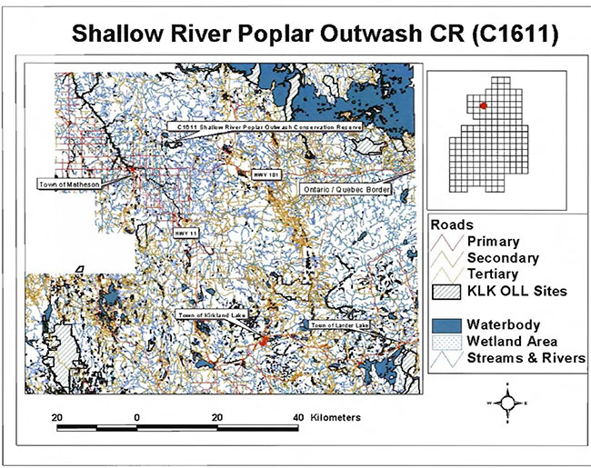
Enlarge Locator Map for Shallow River Poplar Outwash Conservation Reserve (C1611)
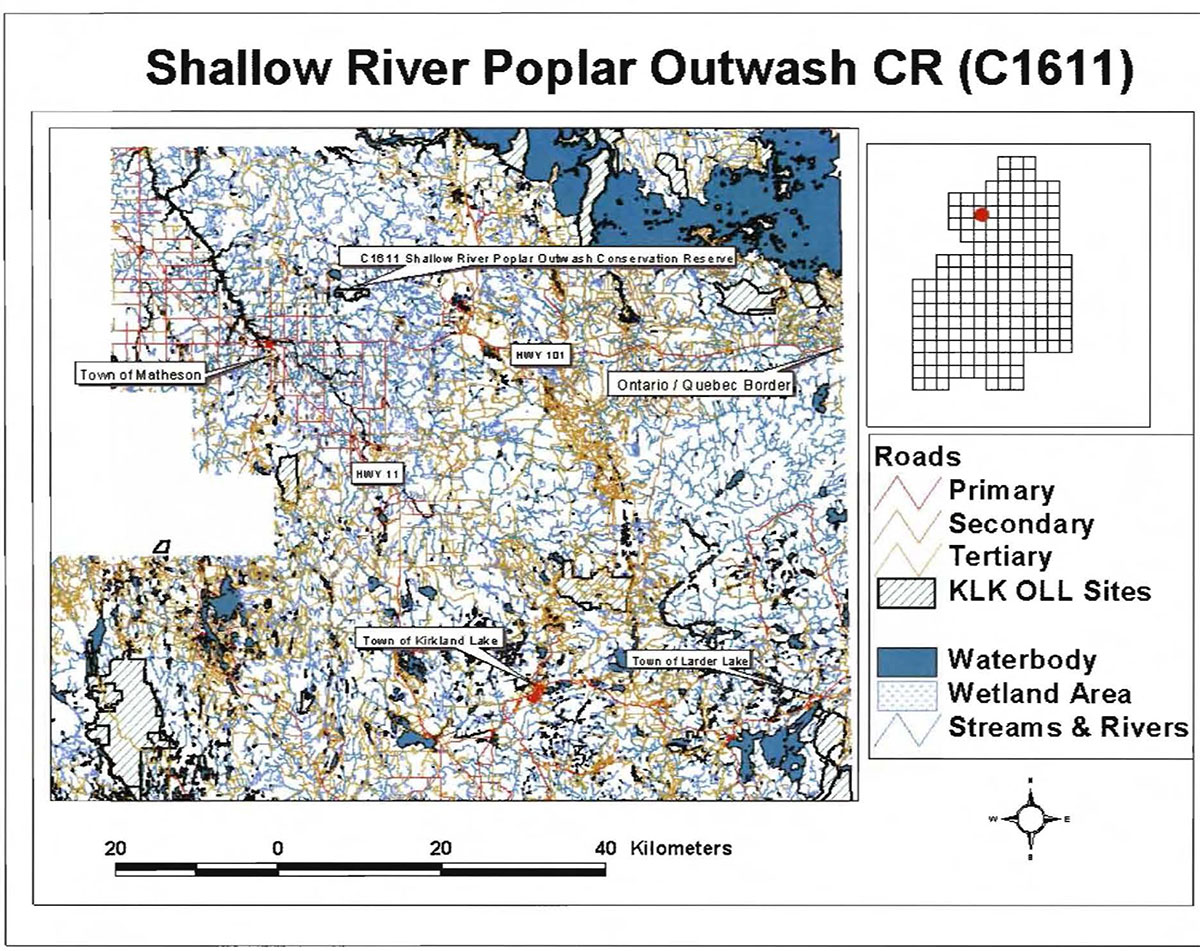
Appendix 8: Natural Heritage – Life Science Checksheet
Natural Heritage Area – Life Science Checksheet
| Name | C1611 Shallow River Poplar Outwash CR |
|---|---|
| Map Name | Matheson |
| Map Number | 42A/09 |
| UTM Reference | 550538 |
| Locality | Cochrane |
| Latitude | 48°35'29"N |
| Longitude | 80°19'39"W |
| NAD | 83 CNT |
| Elevation – Minimum | 280 m |
| Elevation – Maximum | 330 m |
| Township | Beatty |
| Area | 396 (includes 140 ha forest reserve) ha |
| Ownership | Crown |
| MNR Region | Northwest |
| MNR District | Kirkland Lake |
| Ecoregion and Ecodistrict | 3E-3 (Hills 1959) 3E-6 (Crins & Uhlig 2000) |
| Landform Unit(s) (preliminary) | 9 Organic deposits 6b Glaciolacustrine deposits – silt and clay 2 Bedrock-drift complex 1 Bedrock outcrops |
| Air Photo (Year-Flight Line-Roll-Numbers) |
94-4820-15-187 to 189 |
Physical and biological features
Representation
Shallow River Poplar Outwash Conservation Reserve (CR) is located approximately 45 kilometers northwest of the town of Kirkland Lake and 10 kilometers northeast of the town of Matheson in Beatty Township. The Kirkland Lake MNR District office assumes responsibility of the site. It is 396 hectares in size and is composed of both vectored and biological boundaries. Access to the site can be gained by harvest roads from concession roads off Highway 101. According to the OLL Land Use Strategy (1999) the CR consists of moderately broken outwash with an old growth aspen stand located near one of the headwaters of Shallow River and Salve Creek. The rest of the CR is exposed bedrock with some marsh lands associated with waterways and lakes bordering the site. Mixed forest and sparse forest are also associated with the wetlands.
The conservation reserve was originally in Hills' (1959) site district 3E-3 (Cochrane) but with boundary re–configurations by Crins and Uhlig (2000) the CR is in the 3E-6 (Kirkland Lake) ecodistrict of the 3E (Lake Abitibi) ecoregion. The Kirkland Lake ecodistrict is characterized by moderately broken plains of bedrock generally covered with sand and silty sand. Several trains of glaciofluvial sand and gravel occur (Hills 1959). The ecoregion landform is characterized by flat to gently rolling, glacial clay and sandplain with local extensive peatlands and wetlands broken throughout by glacial features such as moraines, eskers and kame/kettle complexes with Canadian Shield exposures. Regional vegetation includes stands of spruce, poplar, birch on fresh sites on moderately sloping terrain and white and red pine on sand ridges. Forest climate type is mid-humid, mid-boreal (Poser 1992).
The conservation reserve is split between bedrock in the south half and glaciolacustrine deposits in the north half according to quaternary geology of Ontario coverage (Map 1b). According to Rik Kristjansson (2004), OLL geologist, these landforms are reversed and the provincial landform coverage has a possible shift in the datum layer. NOEGTS (Northern Ontario Engineering Geology Terrains Study) (Lee 1979) interpretation of the site is similar to Kristjansson’s. Organic deposits are located around Slave Lake and in the creek system east and west of the lake. Bedrock (moderate relief, jagged and cliffed) can be found in the north half while the center contains a glaciolacustrine plain of clay and silt (low relief, mixed wet and dry) with bedrock as the subordinate landform. Kristjansson states the CR is predominantly a bedrock terrain with glaciolacustrine deposits of silt and clay in the depressions. It is undecided whether to call the area unit 2 (bedrock-drift complex) or 1, 6b (bedrock outcrops with glaciolacustrine deposits). The middle portion contains glaciolacustrine deposits of silt and clay (unit 6b). The rest of the area, mainly around Slave Lake, contains discontinuous veneers of organics (unit 9) over glaciolacustrine.
The conservation reserve is in section B.4 (Northern Clay) of the Boreal Forest (Rowe 1972. It contains widespread surface deposits of water-worked tills and lacustrine materials and a nearly level topography, inheritances from glacial Lake Ojibway. The area is underlain predominantly by Precambrian volcanic and granitic rocks. As a result of these landforms, black spruce stands are endless which cover rising uplands as well as lowland flats, alternating in the latter with extensive fens and bogs. With slight changes in relief, forest communities change to hardwood or mixedwood stands of trembling aspen, balsam poplar, balsam fir, white spruce and black spruce. Jack pine can be found on dry sites such as outwash deposits, old beaches and eskers along with white birch. Poorly drained flats, relatively few lakes and clay-banked, rather sluggish streams are characteristic of this section.
The site is dominated by Po mixedwoods
The forest communities were re-classified into Standard Forest Units (SFU's), a language that is common among forest industries and is a more ecological approach to describing forest communities. The five forest communities were classified into three SFU's. The dominant unit is P01 (poplar) which accounted for 46.0% of the total area. The other two SFU's include SB1 (black spruce lowland) (9.6%) and MW2 (spruce fir mixed) (3.9%) (Appendix 2).
Wetlands
The site is in the 4MB tertiary watershed of the Moose River major basin. The headwaters of Salve Creek are approximately 200 meters south of the southeast corner of the CR. The creek flows south into Black River, a major river flowing into the Abitibi River. Salve Creek is an important waterfowl staging area (Map 3a). No fisheries values are known for Salve Lake
(Verify with District).
The Po mixedwood stand provide early wintering habitat for moose (Map 3a). The forest community is mature and contains clumps of conifer (jack pine, black and white spruce) for shelter and a lot of shrubs in the undergrowth (Nicholson 2003). Other values include trapline KL002 and KL007 and bear management area KL-28-007.
Condition
Condition
Diversity
Diversity is a measure of the site’s life and earth science heterogeneity. It is based on the number and range (variety) of the natural landscape features and landforms for earth science values and the relative richness and evenness of the site’s life science components. Richness refers to the number of cover types or vegetative cover types. For this CR, diversity
Evenness
Ecological considerations
Whenever possible, a site’s boundaries should be created to include the greatest diversity of life and earth science features to provide maximum ecological integrity. It should be ecologically self-contained, bounded by natural features and include adequate area to buffer the core ecosystems from intrusive influences (OMNR 1992). The CR contains a mixture of biological and vectored boundaries. The biological boundaries are restricted to Salve Creek and Lake and a small feeder creek to Salve Creek. The rest is vectored. The southeast corner and west side are adjacent to patent lands. It is difficult to use natural boundaries on the north side as there are no natural features unless it is extended to Shallow River to the north.
When a site is designed, rounder sites are preferred over elongated sites as they have more intact core area and better buffering capacity from adjacent land use activities. Based on this statement, C1611 is further flawed in its design. It is rather elongated in that the east-west length is three times longer than the north-south width. Little core area remains on both the east and west ends using the 200 meter buffer (Ontario Parks(1) 2003).
Currently we do not have minimum size standards for conservation reserves under different landscape conditions. However, a minimum size standard of 2000 ha has been established for natural environment parks by Ontario Parks (OMNR 1992). This minimum standard was considered necessary to protect representative landscapes as well as allow for low intensity recreational activities. Large sites are preferred over small sites as it has greater potential for ecological diversity and stability. This conservation reserve falls short of the minimum standard at 396 hectares. With its shape, size and vectored boundaries buffering capacity is greatly reduced. Diversity is also greatly reduced (approximately 13 L:V's) due to its small size.
The headwaters of Salve Creek are located just outside the CR in patent land and part of the creek forms the south boundary. No protection is available at the source of the headwaters. As part of headwater wetlands, the creek and lake act as important groundwater recharge areas (OMNR 1993). Its underlying soils (silt and clay) provide some efficiency in conveying ponded water to groundwater. The large bog and floating mat complex on Salve Lake are actively accumulating organic soils in the form of peat and acting as a sink for carbon dioxide. The thicket swamps on Salve Creek, upstream from Salve Lake, also provide some erosion control during spring time flooding.
Special features
Special features include:
- The dike structure on Salve Creek built by Ducks Unlimited for wetland enhancement
- Headwaters of the Salve Creek in and near the conservation reserve
- Salve Creek and Salve Lake are important waterfowl staging area
- The aspen communities provide an early wintering area for moose
Major information sources
Arnup, R., G.D. Racey and R.E. Whaley. 1999. Training manual for photo interpretation of ecosites in northwestern Ontario. NWST Technical Manual TM-003.127p.
Bridge, Simon; Watt, Robert; Lucking, Greg; and Brian Naylor. 2000. Landscape analysis for forest management planning in boreal northeastern Ontario. OMNR, Northeast Science & Technology. 36p.
Crins, W.J. and P. W. C. Uhlig. 2000. Ecoregions of Ontario: Modifications to Angus Hills' Site Regions and Site Districts – Revisions and Rationale.
Harris, A.G., S.C. McMurray, P.W.C. Uhlig, J.K. Jeglum, R.F. Foster and G.D. Racey. 1996. Field guide to the wetland ecosystem classification for northwestern Ontario. Ont. Min. Natur. Resour., Northwest Sci. & Technol. Thunder Bay, Ont. Field Guide FG-01. 74 pp. + append.
Hills, G.A. 1959. A Ready Reference to the Description of the Land of Ontario and its Productivity.
Kristjansson, R. 2004. Personal Conversation.
Lee, Hulbert A. 1979. Northern Ontario Engineering Geology Terrain Study, Data Base Map, Kirkland Lake. Ontario Geological Survey, Map 5027, Scale 1:100 000.
Nicholson, Jane. 2003. C1611 Aerial Reconnaissance Notes.
Noble, T.W. 1983. Central Boreal Forest Region (3E). Life Science Report. Northeastern Region. Internal report.
Ontario Ministry of Natural Resources. 2002. MNR Districts and Major Basins of Ontario.
Ontario Ministry of Natural Resources. 1999. Ontario Living Legacy Land Use Strategy.
Ontario Ministry of Natural Resources. 1993. Ontario Wetland Evaluation System – Northern Manual. NEST Technical Manual TM-001. March 1993.
Ontario Ministry of Natural Resources. 1992. Ontario Provincial Parks: Planning and Management Policies – 1992 Update
Ontario Parks (1). 2003. Life Science Check Sheet Guidelines – Draft. Internal document. February 2003.
Ontario Parks (2) 2003. Landform Vegetation Representation Summary for site C1602 in Ecodistrict 3E-5. (May 2003). Internal Report
Poser, S. 1992. Report on the Status of Provincial Parks in the Site Regions and Districts of Ontario. Ministry of Natural Resources Report.
Rowe, J.S. 1972. Forest Regions of Canada. Department of Fisheries and the Environment-Canadian Forestry Service Publication No. 1300. 172p.
Taylor, K.C., R.W. Arnup, B.G. Merchant, W.J. Parton and J. Nieppola. 2000. A field guide to forest ecosystems of Northeastern Ontario. 2nd Edition. Northeast Science and Technology NEST Field Guide FG-001.
Thompson, John E. & Jake Noordhof. 2003. Edit Model for N.E. Region Life Science Checksheets. Internal Report.
Significance Level (Provincial/Regional/Local) and Brief Summary of Major Representative Values
The OLL Land Use Strategy states the Shallow River Poplar Outwash CR is a site comprised of moderately broken outwash with old growth poplar/aspen stand near one of the headwaters of Shallow River and Salve Creek. The rest of the site is exposed bedrock with some marsh lands associated with waterways and lakes bordering the site. This description is based on the original blue line (Appendix – History map) which extended further north from the current configuration. Based on Kristjansson’s interpretation and NOEGT, the significance has to be re-visited as the site is dominated by glaciolacustrine deposits and bedrock with some organics, not by outwash. The aspen forest communities have not reached the old growth stage, using stage development definitions by Simon et al (2000).
In the analysis conducted by Ontario Parks (2) (2003), the CR is dominated by mixed deciduous forest on glaciolacustrine deposits and dense deciduous forest on bedrock. The deciduous forests would be equivalent to P01 and MW2 in our analysis. Although there is a 'shift' in the landform layer, these landform:vegetation units are present in the CR. Unfortunately, they are not significance as these units are well represented elsewhere in the ecodistrict. The CR is significant for treed bog on organic deposits and open bog on organic deposits as the total protected areas does not meet the ecodistrict requirement.
Sensitivity
The conservation reserve is bound by mining leases on the east and west sides. Any mining activity that occurs in these areas that is not monitored may have some impact on the headwaters of Salve Creek and ultimately water quality downstream.
Recommendations
- This second step checksheet should be advanced to a fourth step by digitizing the earth science data based on Kristjansson’s interpretations of aerial photos, once these become available and used with SFU to complete a current landform:vegetation analysis. Finally, the checksheet could be advanced to a fifth step by comparing the fourth step checksheet with the current provincial landform layers based on the new regulated boundary to see if comparisons can be made. In turn we can determine more fully the site’s significance and contribution to the parks and protected areas program.
- The vectored boundaries for the site should be marked to ensure that the values within the site are protected from surrounding land use activities. Further analysis and assessment may require additional management prescription to ensure long term protection of the site’s natural heritage values.
- The forest reserves should be amalgamated into the conservation reserve as it contains headwaters for Salve Creek in the east end and the west end contains a wetland enhancement structure built by Ducks Unlimited.
- Funding should be secured in the near future to determine the number and location of roads and trails currently present within the site using current global positioning technologies.
- Any future trail development must consider the values found within the boundaries of the site, the rationale for developing trails within the site and the availability of current access through the site and surrounding areas. Furthermore, any new trail development will require a 'Test of Compatibility'. Low-lying areas and wetlands should be avoided.
- Overall custodial management is the responsibility of the district office with support from the regional natural heritage specialist and Ontario Parks. To advance conservation reserve custodial management, future managers will need to monitor the current state of the CRs resources at least at the community and landscape levels within and adjacent to the conservation reserve and its surrounding environment. Such monitoring could include: evaluating and reporting on changes such as; natural disturbances (i.e. fire, insect/disease, wind throw, etc.), human disturbances (i.e. forest harvesting, access and/or other land use activities) as well as management prescriptions (i.e. rehabilitation efforts and/or vegetative management planning).
- Ongoing evaluations and reports will have to rely on current and new technologies such as satellite imagery, global positioning systems (GPS), supplementary aerial photography (SAP) and/or aerial/ground reconnaissance surveys/assessments conducted periodically and placed within a GIS database. Such tools could help managers spatially record areas affected severity of perturbations or management action as well as consider the sensitivity of values, the design of CR and determine the future desired condition of the site. Monitoring efficiencies could be enhanced via partnerships and internal coordination within MNR.
footnote 7
| Time Effort Spent on Site | September 22, 2003 |
|---|---|
| Date Compiled | March 30, 2004 |
| Compiler(s) | Barbara Burkhardt, Lori King, Sean Longyear |
| Date Reviewed | |
| Reviewer |
Map 1a: Surficial Geology Shallow River Poplar Outwash Conservation Reserve (C1611)
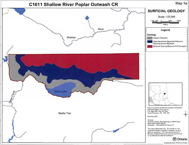
Enlarge Map: Surficial Geology Shallow River Poplar Outwash Conservation Reserve (C1611)
Map: Geology Shallow River Poplar Outwash Conservation Reserve (C1611)

Enlarge Map: Geology Shallow River Poplar Outwash Conservation Reserve (C1611)
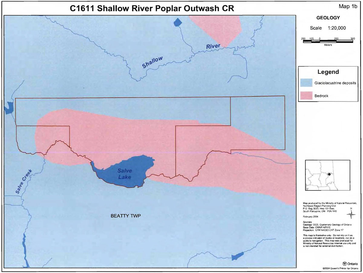
Map: Forest Communities Shallow River Poplar Outwash Conservation Reserve (C1611)
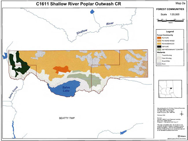
Enlarge Map: Forest Communities Shallow River Poplar Outwash Conservation Reserve (C1611)
Map: Stocking Distribution Shallow River Poplar Outwash Conservation Reserve (C1611)
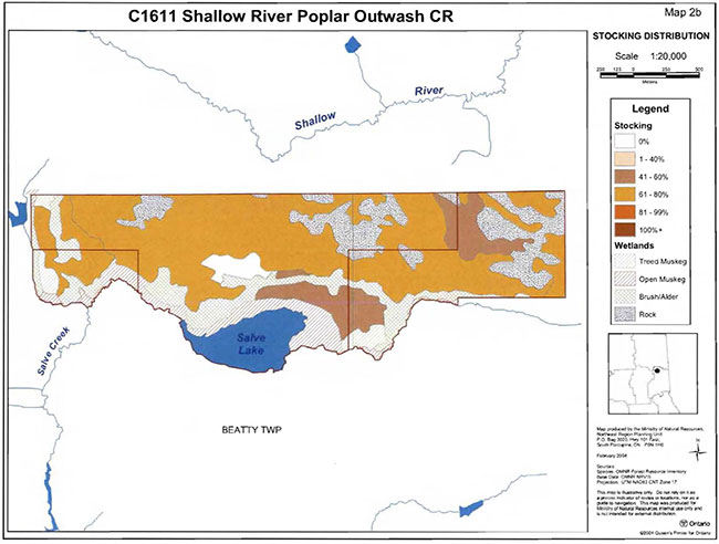
Enlarge Map: Stocking Distribution Shallow River Poplar Outwash Conservation Reserve (C1611)
Map: Age Distribution Shallow River Poplar Outwash Conservation Reserve (C1611)
Enlarge Map: Age Distribution Shallow River Poplar Outwash Conservation Reserve (C1611)
Map: Stand Forest Units Shallow River Poplar Outwash Conservation Reserve (C1611)

Enlarge Map: Stand Forest Units Shallow River Poplar Outwash Conservation Reserve (C1611)
Map: Values Shallow River Poplar Outwash Conservation Reserve (C1611)
Enlarge Map: Values Shallow River Poplar Outwash Conservation Reserve (C1611)
Map: Wetlands Shallow River Poplar Outwash Conservation Reserve (C1611)
Enlarge Map: Wetlands Shallow River Poplar Outwash Conservation Reserve (C1611)
Map: Old Growth Shallow River Poplar Outwash Conservation Reserve (C1611)
Enlarge Map: Old Growth Shallow River Poplar Outwash Conservation Reserve (C1611)
Map: History Shallow River Poplar Outwash Conservation Reserve (C1611)

Enlarge Map: History Shallow River Poplar Outwash Conservation Reserve (C1611)
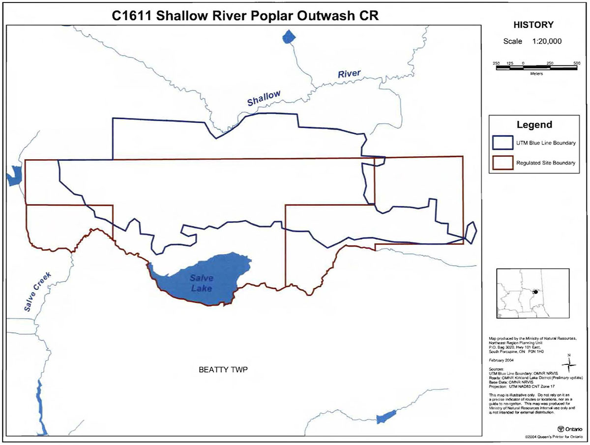
Appendix 9: Earth Science Checksheet
Shallow River Poplar Conservation Reserve (C1611)
Approved Earth Science Checksheet
Kirkland Lake
January 12, 2005
Prepared by: F.J. (Rik) Kristjansson
Earth Science Inventory Checklist
| Name | Matheson |
|---|---|
| NTSNumber | 42 A/09 |
| UTM Ref. (Datum) | 550538 |
| Latitude | 48° 35' 29" N |
| Longitude | 80° 19' 39" W |
| NAD | 83 |
| Elevation Minimum | 280m asl |
| Elevation Maximum | 330m asl |
| Locality | Cochrane |
| Township(s) | Beatty |
| Area (ha) | 396 ha |
| MNR District | Kirkland Lake |
| MNR Region | Northwest |
| Aerial Photographs | 94-15, 4820, 187 to 190 |
| Prepared by: | F.J. Kristjansson, Consulting Geoscientist |
| Reviewed by: | Phil Kor, Senior Conservation Geologist |
| Date: | January 12, 2005 |
Map: Earth Science Inventory Checklist
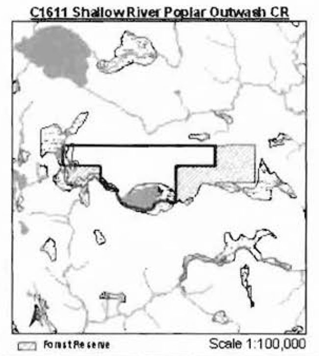
Earth science features
Bedrock Geology: Based on Map 2543 (Ontario Geological Survey, 1991), the Shallow River Poplar Outwash Conservation Reserve is underlain by undifferentiated metavolcanic rocks of the Abitibi Subprovince, Superior Province, Precambrian Shield.
Surficial Geology: Based on a brief helicopter reconnaissance survey, review of surficial geological mapping (Vagners, I 984, Map P.2735), review of tenain geological mapping (Lee, 1979, Data Base Map 5027), and interpretation of available aerial photography, the Shallow River Poplar Outwash Conservation Reserve is immediately underlain by areas of Bedrock Outcrop (Unit 1 ,2), Glaciolacustrine Deposits (Unit 6,9/6), and Organic Deposits (Unit 9). It is noted that the writer’s interpretation of the surficial geology compares closely with the published maps of Yagners (I 984, Map P.2735) and Lee (I 979, Data Base Map 5027). Please refer to the attached preliminary surficial geological mapping for the occurrence and distribution of the indicated surficial geological units within the conservation reserve (Appendix A).
Most of the north half of the conservation reserve is immediately underlain by bedrock terrain (Photo. C1611-01), classified as Bedrock Outcrop (with subordinate areas of Bedrock-Drift Complex) (Unit 1,2). With reference to the morphology of the bedrock surface, bedrock knob (or knoll) forms are most characteristic. The compound map unit designation, that is, Unit 1,2, denotes a complex of the indicated surficial geological classes. Major bedrock exposure (>75 %bedrock outcrop is estimated) associated with a thin, discontinuous cover of drift represents the dominant surficial geological condition, and is generally anticipated within Unit 1,2. Moderate bedrock exposure associated with a thin and/or discontinuous cover of drift represents the subordinate surficial geological condition. The associated cover of drift consists of glaciolacustrine silt and clay, although till deposits may also be present.
In contrast to the north half of the conservation reserve, most of the south half is immediately underlain by glaciolacustrine deposits and organic deposits. A narrow, generally east-west trending area, immediately underlain by Glaciolacustrine Deposits (Unit 6,9/6), is situated immediately adjacent to the bedrock terrain described in the previous paragraph. These glaciolacustrine deposits are extensively dissected, and consist largely of silt and clay. Organic deposits, primarily veneers overlying glaciolacustrine silt and clay, occur locally within this area of glaciolacustrine deposits. Finally, a narrow, generally east-west trending area, immediately underlain by Organic Deposits (Unit 9), occupies the remaining area of the conservation reserve (Photo. C1611-01, and Photo. C1611-02). To a large extent, if not exclusively, these organic deposits are immediately underlain by glaciolacustrine silt and clay.
Significance: The geological features described above are commonly encountered within the surrounding region, and are considered to be of local significance.
Sensitivity: Considering the relatively passive land uses anticipated within a conservation reserve (e.g., hunting), the various geological features (with the exception of organic deposits) are considered to have low sensitivity. Organic deposits (i.e., peatlands) may be sensitive to ATV or "all-terrain vehicle" traffic.
Recommendations: None
References:
Lee, H.A., 1979; Northern Ontario Engineering Geology Terrain Study, Data Base Map, Iroquois Falls; Ontario Geological Survey, Map 5027, Scale 1:100,000.
Savage, W.S., Thomson, R., and Fenwick, K.G., 1962; Bedrock Geology of the Iroquois Falls-Lake Abitibi Sheet, District of Cochrane; Preliminary Map P.l40, Geological Compilation Series, Scale 1 inch to 2 miles.
Vagners, U.J., 1984; Quaternary Geology of the Matheson Area, District of Cochrane; Ontario Geological Survey, Preliminary Map P.2735, Geological Series, Scale 1:50,000. Geology 1983.
Appendices:
Appendix A: Preliminary Surficial Geology of the Shallow River Poplar Outwash Conservation Reserve (C1611)
Photographs:
Photo. C1611-0l
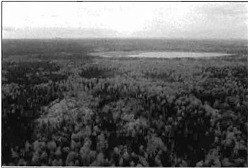
Provides a view approximately south across the central part of the conservation reserve. Most of the north half of the conservation reserve is immediately underlain by bedrock terrain, classified as bedrock outcrop (with subordinate areas of bedrock-drift complex). Note the exposed bedrock, particularly evident in the central and left foreground of the photograph. Also, note the organic deposits associated with the Salve Lake basin in the upper central and upper right parts of the photograph.
Photo. C1611-02
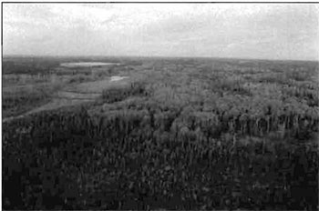
Provides a view approximately west across the east and central parts of the conservation reserve. In contrast to the north half of the conservation reserve, the south half is dominated by glaciolacustrine deposits and organic deposits. Note the areas of organic deposits, generally, the tan brown to very pale green areas, in the central left and upper left parts of the photograph. Salve Lake is evident in the upper left part of the photograph.
Appendix A: Preliminary Surficial Geology of the Shallow River Poplar Outwash Conservation Reserve (C1611)
Footnotes
- footnote[1] Back to paragraph Mixedwoods are defined as follows: hardwood mixedwoods are stands dominated by hardwoods with less than 30% cover of conifer in the main canopy; similarly conifer mixedwoods contain less than 30% hardwoods in the canopy. Mixedwoods contain approximately equal percentages of conifer and hardwood trees and true mixedwoods contain a 50:50 split between conifers and hardwoods (modified after Taylor et al 2000).
- footnote[2] Back to paragraph Conifer stands are defined as follows: pure conifer stands contain 100% of a conifer trees in the canopy; dominant conifer stands contain less than 10% cover of hardwoods in the main canopy and predominant conifer stands contain less than 20% cover of hardwoods in the main canopy. Similarly hardwood stands may contain no conifer in canopy (pure hardwood), less than 10% conifer (dominant hardwood) or less than 20% conifer cover (predominant hardwood) (modified after Taylor et al 2000).
- footnote[3] Back to paragraph Wetlands were classified after Amup et al. 1999 and Harris et al 1996.
- footnote[4] Back to paragraph Rating based on the amount of area currently under some form of known disturbance. High is >20% of the area, medium 10 to 20 %, low <10% and pristine <1%.
- footnote[5] Back to paragraph Diversity rating, developed by John Thompson & Jake Noordhof (2003), is based on the size of the conservation reserve versus the number of landforms:vegetation (SFU/HU) combinations. For CR's < 500 ha, high diversity is >25 L:V combinations, medium for >15 L:V, and low for < 15 L:V. For areas 500-2000 ha, high is >30,medium >20 and low < 20. For areas >2000 ha. high >35, medium >25 and low < 25 L:V combinations.
- footnote[6] Back to paragraph Evenness of the site defined as strongly skewed (top 3 communities capture >=60% of the site in area), moderately skewed (30-59%) or slightly skewed to even (<30%).
- footnote[7] Back to paragraph Coordination could include a variety of expertise from the following: Field Services Division, Ontario Parks, Aviation and Forest Fire Management Branch, Forest Health and Silvicultural and Forest Management Planning Sections, Northeast Science and Information etc. Additional expertise within and outside the MNR could be sought as required.