Smoky River Headwaters Conservation Reserve Management Statement
This document provides policy direction for the protection, development and management of the Smoky River Headwaters Conservation Reserve and its resources.
(C145)
Statement of Conservation Interest
Ontario Ministry of Natural Resources
North Bay District
Approval statement
We are pleased to approve this Statement of Conservation Interest for the Smoky River Headwaters Conservation Reserve (C145).
Smoky River Headwaters Conservation Reserve is a 928 hectare parcel of Crown land, located approximately 20 km northeast of Sturgeon Falls. The conservation reserve is located in ecodistrict 5E-6 (Hills, 1959; Crins, 2000). The area is dominated by flat wetland communities, in particular an open fen.
Smoky River Headwaters Conservation Reserve is one of 378 new protected areas approved through Ontario’s Living Legacy, a land use strategy aimed, in part, at completing Ontario’s system of parks and protected areas.
During the Lands for Life planning process the public was widely consulted and provided valuable input into what became Ontario’s Living Legacy. Comments received during that time, and during consultation related to the formal Public Lands Act regulation of the boundaries of this conservation reserve were generally supportive of the protection of this area.
Stakeholders who expressed an interest in the planning of this site were notified regarding the draft SCI and given a two-week review period. Any comments, including input from previous consultation, were considered in the finalization of this document. There was limited interest expressed by the public during the review of the draft SCI. No new issues have been identified. This SCI was also reviewed by MNR staff.
This SCI provides guidance for the management of the conservation reserve and the basis of the ongoing monitoring of activities. More detailed direction is not anticipated at this time. Should significant facility development be considered or complex issues arise requiring additional studies, more defined management direction or special protection measures, a more detailed Resource Management Plan will be prepared with full public consultation.
Smoky River Headwaters Conservation Reserve is managed under the direction of the District Manager and the Tomiko Area Supervisor, North Bay District, Ministry of Natural Resources.
Prepared by:
Cora A. Sheppard
OLL Planning Intern
Date: December 02, 2003
Original signed by:
Dave Payne
District Manager
North Bay District
Date: December 17, 2003
Original signed by:
Rob Galloway
Regional Director
Northeast Region
Date: January 9, 2004
1.0 Introduction
The purpose of this Statement of Conservation Interest (SCI) is to identify and describe the values of the Smoky River Headwaters Conservation Reserve. The SCI also outlines the activities that occur within the conservation reserve and provides guidelines for the management of current and future activities in the context of protecting the natural, social and cultural values of the conservation reserve. A SCI is prepared under the authority of Procedural Guideline A – Resource Management Planning (PL. Procedure 3.03.05).
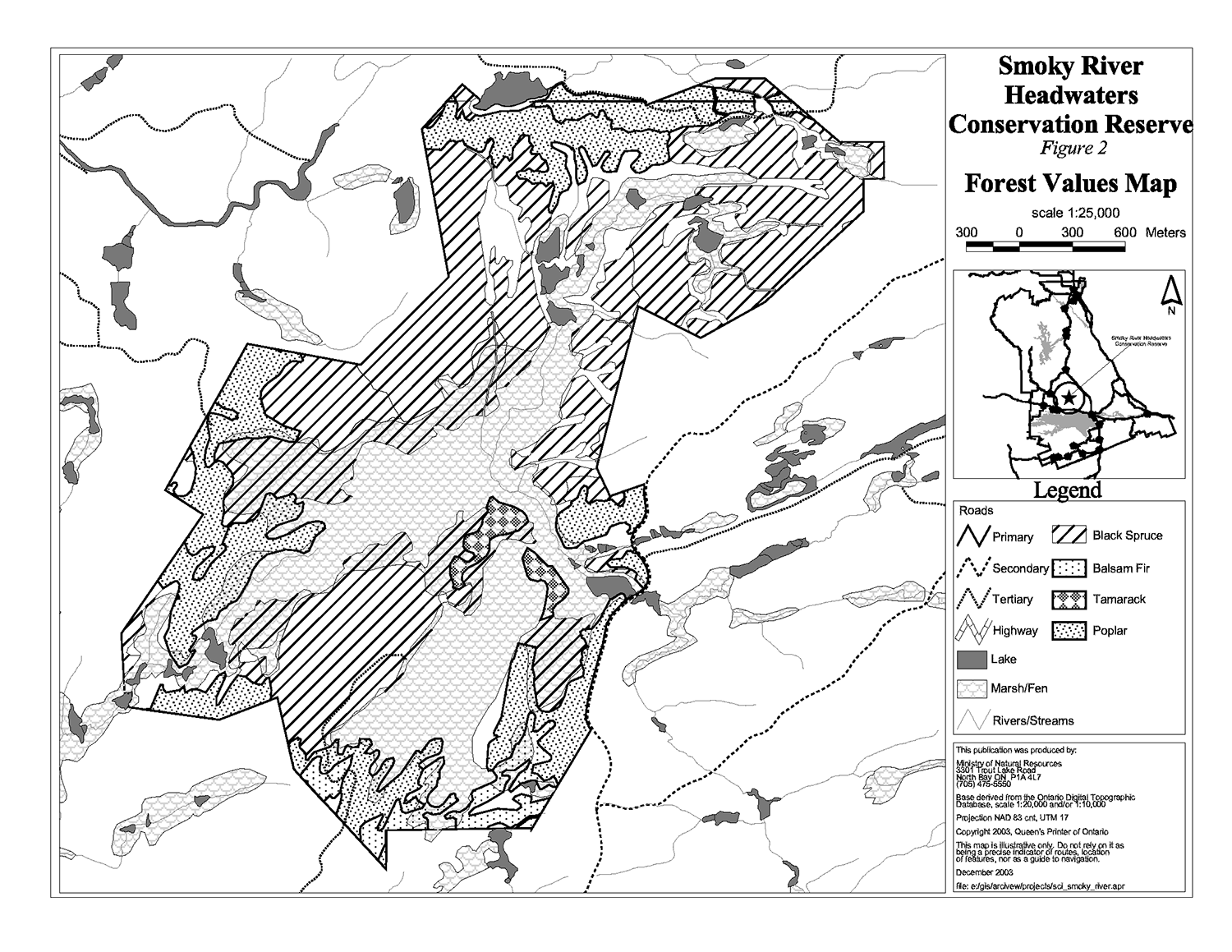
Smoky River Headwaters Conservation Reserve is located southwest of Tomiko Lake, south of Tomiko River (Figure 1). The boundary of the conservation reserve is located in the geographic townships of Grant and Charlton within the Municipality of West Nipissing. Flat wetland communities including a diversity of marshes and boreal type woodlands of black spruce and tamarack dominate the conservation reserve (Figure 2).
Conservation reserves are established by regulation under the Public Lands Act. Smoky River Headwaters Conservation Reserve was established by Ontario Regulation 313/02, under authority of the Public Lands Act (O. Reg. 805/94) on December 7, 2002. The planning area for this SCI is the regulated boundary of the conservation reserve.
1.1 Planning context
Ontario’s Living Legacy Land Use Strategy was approved in 1999. The objectives of the Land Use Strategy are to complete Ontario’s system of protected areas; recognize the land use needs of resource-based tourism industry; provide forestry, mining and resource industries with greater certainty around land and resource use; and enhance hunting, angling and other Crown land recreational opportunities. Smoky River Headwaters Conservation Reserve was created as part of the expansion of protected areas.
Conservation reserves protect natural heritage values on public lands, while permitting compatible land use activities. By allocating these lands to the parks and protected areas system through regulation, the province has ensured a certain level of permanence by distinguishing the conservation reserve and its values from the larger general use or more extensively managed landscape. In addition, the conservation reserve’s natural features are, and will be available for present and future generations to enjoy and explore.
Ontario’s Living Legacy Land Use Strategy (1999) outlines the general land use policy and management direction for new conservation reserves. Each new conservation reserve will have a planning document, either a SCI or, in more complex situations, a Resource Management Plan, that details site-specific management direction.
Comments received during the Lands for Life process, and during consultation related to the formal regulation of the boundaries of this site were generally supportive of the establishment of this area as a conservation reserve. Stakeholders who expressed an interest in the planning were notified regarding the draft SCI and given a two-week review period where the draft was made available. Any comments, including input from previous consultation, were considered in the finalization of this document. There was limited interest expressed by the public during the review of the draft SCI. This SCI was also reviewed by MNR staff.
Although more detailed direction is not anticipated at this time, should significant facility development be considered or complex issues arise requiring additional studies, more defined management direction or special protection measures, a more detailed Resource Management Plan will be prepared with full public consultation.
1.2 Background information
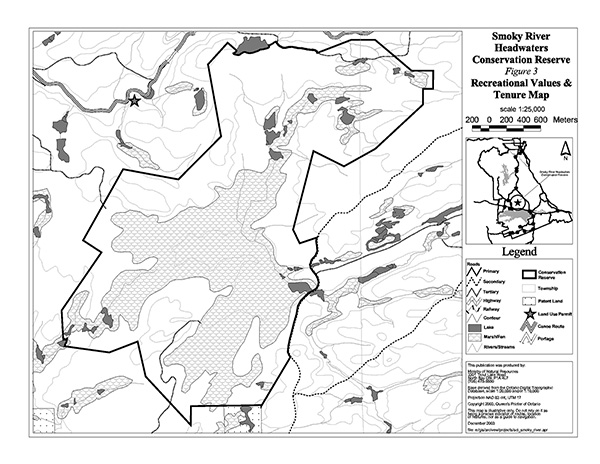
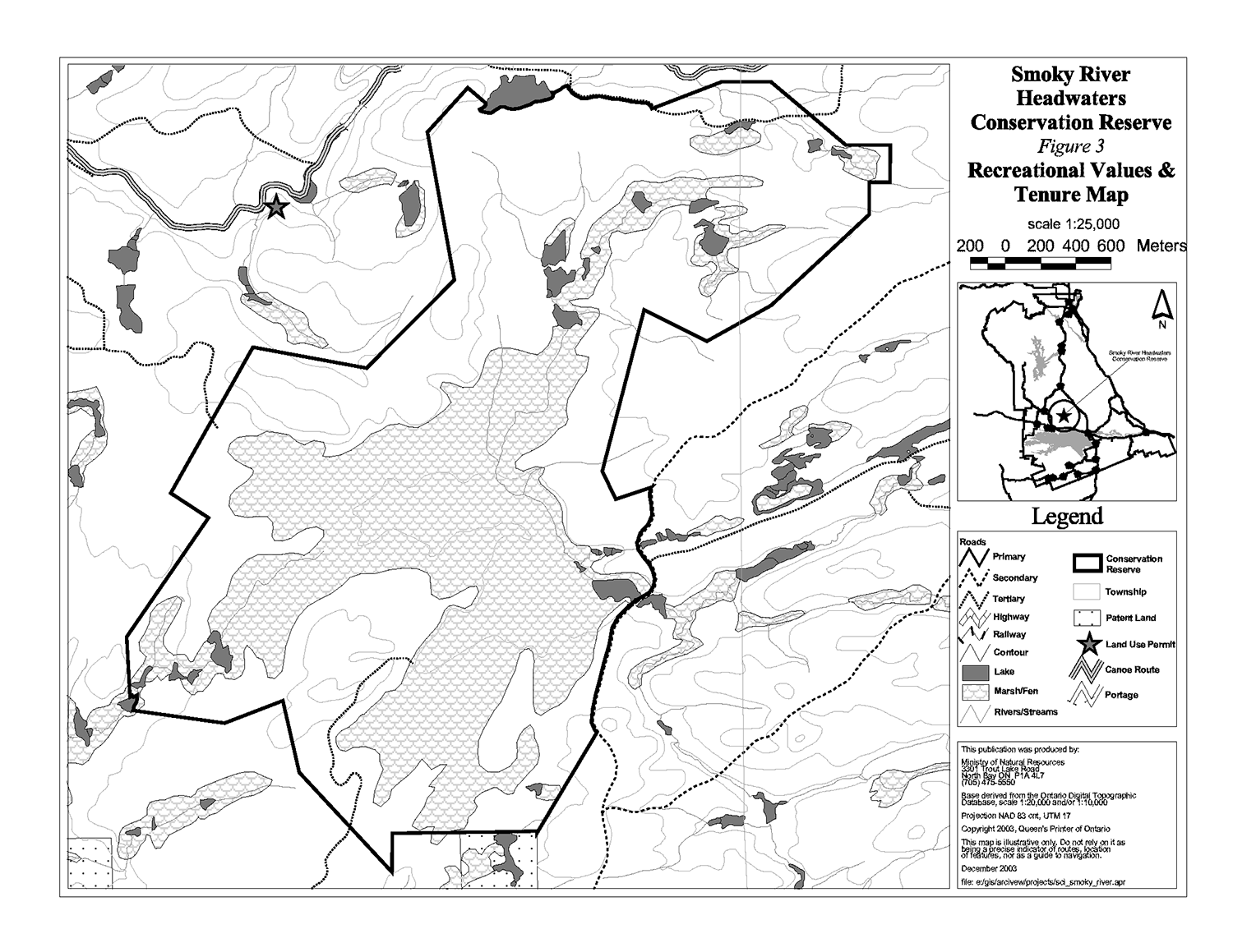
Smoky River Headwaters Conservation Reserve is a wetland area south of the Tomiko River and northeast of the Town of Sturgeon Falls. This area has been protected to preserve valuable wildlife habitat and the headwater detention area of several tributaries of Smoky River. The area can be accessed by a trail forming the eastern boundary. This trail is suitable for an all-terrain vehicle, but can not be accessed by a larger vehicle.
The following chart summarizes administrative information for Smoky River Headwaters Conservation Reserve:
| Name and OLL ID Number | Smoky River Headwaters Conservation Reserve (C145) |
|---|---|
| Ecoregion/Ecodistrict (Hills, 1959; Crins, 2000) | 5E (Georgian Bay), 5E-6 (Tomiko) |
| OMNR Administrative Region/District/Area | Northeast Region/North Bay District/ Tomiko Area |
| Total Area (ha.) | 928 |
| Regulation Date | December 7, 2002 (O. Reg. 805/94) |
| Township(s) | Grant, Charlton |
| First Nations | Robinson-Huron Treaty Nipissing First Nation traditional area |
| OBM map sheets | 2017 5900 51400 |
| Topographic Map Name/Number | 31 L/5, Sturgeon Falls |
| UTM coordinates | 593,300 m E 5,147,500 m N |
| General Location, Description, Access | Approximately 20 km northeast of Sturgeon Falls. Site is dominated by flat wetland communities. There is limited vehicular access to the site, as the trails leading into the conservation reserve have become overgrown. |
1.3 Goals
The goals of this SCI are:
- To provide background information
- To identify and describe the values of the conservation reserve
- To provide guidelines for the management of current and future activities while protecting natural, social and cultural heritage values
1.4 Objectives
The following objectives are identified as a means to achieve the above stated goals.
- To describe the state of the resource with respect to natural heritage values and current land use activities
- To manage the conservation reserve to protect the integrity of its natural values via specific guidelines, strategies and prescriptions
- To meet planning requirements by addressing the management intent of the conservation reserve and addressing planning and management needs
- To create a public awareness of the values within the conservation reserve and promote responsible stewardship of the protected area through partnerships with local stakeholders
- To determine long-term management goals of the conservation reserve by identifying research, client services and marketing strategies
- To identify scientific values on the site in relation to provincial benchmarks and identify the necessary monitoring and/or research to maintain the integrity of those values
- To provide direction to evaluate new uses or economic ventures through the application of Test of Compatibility ((Procedural Guideline B) - Land Uses - 3.03.05) (Appendix 1)
1.5 Representation
The following table provides a summary of the life science, earth science and cultural heritage values, as well as recreational opportunities.
Life science representation:
19 vegetation community types on landform 1a-19 (Glaciolacustrine silt on clay plain) The following landform types and vegetation associations are found:
- Area is dominated by an open fen, treed peatland and conifer swamp
- Broken shallow sandy till plain
- Expanses of organic terrain
- Emergent marsh vegetation
- Black spruce lichen woodland
- Raised sandy beach ridge (Bergsma, 1995)
Earth science representation:
Glaciolacustrine plain adjacent to the Sturgeon River. Within biophysiograhic unit of shallow sandy till plain with intermittent rock knobs and expanses of organic terrain. Soils are lacustrine sand, silt and clay (Bergsma, 1995).
Cultural heritage values:
No in-depth research has been completed to date. District cultural heritage maps were reviewed and no values were identified.
Recreational opportunities:
The conservation reserve offers recreation opportunities such as hunting and bird watching. Use of the area is currently limited due to the poor condition of existing trails. Access to the conservation reserve can only be achieved by all-terrain vehicle.
1.6 Survey work
The following table provides an overview of inventories completed, their level of detail, and any further inventories that are required.
| Survey Level | Life Science | Earth Science | Cultural | Recreational |
|---|---|---|---|---|
| Reconnaissance | Burkhardt, B., 2003, Life Science Checksheet Aerial Survey |
Kristjansson, F.J., 2003, Earth Science Checksheet, Aerial Survey | No values identified | Tremblay, D., 2002, Recreational Inventory Checksheet, Aerial and Ground Survey |
| Detailed | Bergsma, 1995 – Compiled from both field survey notes and aerial reconnaissance |
None | None | None |
| Requirement | None | None | None | Monitor on on-going basis |
2.0 State of the resource
The conservation reserve is located entirely within Crins and Uhlig (2000) Ecodistrict 5E-6. Values include life science, earth science and recreational/aesthetic with an emphasis on the life sciences.
Significance is determined on the basis of the following criteria: representation, diversity, condition, ecological considerations and special features (Crins and Kor 1998).
- Representation: The conservation reserve represents 19 different communities dominated by an area of open fen, treed peatland and conifer swam Also present are expanses of organic terrain, emergent marsh vegetation, a raised sandy beach ridge and black spruce lichen woodland (Bergsma, 1995).
-
Diversity: Diversity is a measure of the conservation reserve’s earth and life science variety. The evaluation is based on the number and range (assortment) of landscape features and landforms for earth science values and the relative richness and evenness of the site’s life science components (Bergsma, 1995).
The diversity in Smoky River Headwaters Conservation Reserve is considered good, especially within the wetland vegetation communities with several types of marsh and swamp as well as fen and conifer swamps. There are at least 102 different species of vascular plants in the conservation reserve (Bergsma, 1995).
- Condition: Overall the conservation reserve is in good condition. There are two areas where timber has been harvested in the southeast portion of the site. The wetland and most of the interior is relatively undisturbed. Areas of upland forest show good natural regeneration of white pine (Bergsma, 1995).
-
Ecological considerations: The design of this conservation reserve includes the main peatland that is a headwater detention area of several tributaries of the Smoky River. The boundary has been established to contain the wetland catchment and some upland areas around the wetland to act as a buffer for the interior wetland. The upland areas also add to the diversity of the conservation reserve (Bergsma, 1995).
A trail system leads into the conservation reserve along the eastern boundary. This could place additional pressure on the conservation reserve by user groups, however the area is mainly used for hunting and trapping.
- Special Features: The conservation reserve contains special Life Science features including moose aquatic feeding areas and waterfowl staging areas. The black spruce and lichen forest is a mature example of a boreal feature (Bergsma, 1995).
2.1 Life science
Gap analysis is a method of identifying gaps in representation of all landform/vegetation features within the Ecodistrict, and to identify potential sites that best fill those gaps. The objective of gap analysis is to complete representation of all vegetation community and landform types within protected areas (Bergsma, 1995). This conservation reserve was identified through gap analysis and contains 19 different vegetation types.
The upland forested communities growing on the sandy glacial deposits are important features for life science study. The conservation reserve is in good physical condition. This area was recommended as a provincially significant site by Bergsma (1995) during field and aerial surveys of the area. This area was selected for its unique representation of a raised beach ridge with boreal lichen forest vegetation. The open fen with mature hummock/hollow phase and the diversity of marsh wetlands are considered unique communities.
2.2 Earth science
The area is underlain by highly deformed and metamorphosed rocks belonging to the Central Gneiss Belt of the Grenville Structural Province. The dominant rock type present in this area is biotite gneiss.
2.3 Cultural values
There are no archeological sites identified within the conservation reserve. There are no identified high potential heritage areas. High potential cultural heritage areas are identified using a computer based predictive modeling program. Based on a series of pre-defined parameters, the program identifies candidate areas, which are most likely to be culturally significant.
2.4 Recreational/aesthetic values
Recreational activities such as hunting and trapping occur within the conservation reserve. There are opportunities for increased hunting, nature study and bird watching, but access to the conservation reserve is limited. There is a trail leading to the northeast corner of the conservation reserve, but it has become overgrown. The trail along the eastern boundary is available via Hwy 17 and Riding Stable Road.
2.5 Heritage estate contributions
This area has been set aside as a conservation reserve to protect unique communities and the headwater detention area for several tributaries of the Smoky River. Smoky River Headwaters Conservation Reserve contains an open fen and a diversity of marsh wetlands, which are considered unique communities in the district. The area was recommended as a Provincially Significant Area by Bergsma (1994) due to this diversity of wetlands. The headwater area also contains wetland vegetation that is not represented anywhere else in Hills (1959) Site District 5E-6. The area provides water filtration to the surrounding hydrological system and good wildlife habitat for waterfowl and moose. This conservation reserve is a beautiful location, remote from human interference and provides good hunting opportunities for recreationists.
3.0 Management guidelines
3.1 Management planning strategies
The land use intent outlined in Ontario’s Living Legacy Land Use Strategy provides context and direction to land use, resource management, and operational planning activities on Crown land. Commitments identified in the above strategy and current legislation (PL Procedure 3.03.05) will form the basis for land use within Smoky River Headwaters Conservation Reserve. For up-to-date information on permitted uses refer to the Crown Land Use Policy Atlas.
Existing permitted uses within the conservation reserve may continue, unless they are shown to have a significant negative impact on the values within the site.
Proposed new uses and development within the conservation reserve will be reviewed on a case-by-case basis. A Test of Compatibility (Appendix 1) must be passed before they are deemed acceptable. The emphasis will be on ensuring that the natural values of the conservation reserve are not negatively affected by current or future land use activities. Therefore, any application for new specific uses will be carefully studied and reviewed. The Ministry, partner organizations and/or proponents may undertake such studies. Applicable environmental assessment requirements will also be met.
3.2 Land tenure
Background:
Smoky River Headwaters Conservation Reserve consists entirely of Crown lands. (Figure 1 and 2). The conservation reserve is surrounded by Crown land, with patent land to the south of the conservation reserve.
There are no recreation camps or land use permits within Smoky River Headwaters Conservation Reserve. There are no snowmobile trails in the conservation reserve.
Guideline:
The sale of Crown lands within the conservation reserve is not permitted. New recreation camps are not permitted.
Unauthorized occupations of lands within the conservation reserve will be handled in accordance with approved policy, and any required structural removal will be at the owner’s expense.
3.3 Development and access
Background:
There are currently no developments within the Smoky River Headwaters Conservation Reserve.
There is one old logging road forming part of the eastern boundary that leads into the northeast corner of the conservation reserve. This trail is degrading and can be accessed with all-terrain vehicles or on foot. The trail is overgrown in areas and is not maintained. The trail is used sparingly. All other trails that were in the area historically have become overgrown and are no longer being used to access the site.
Guideline:
New roads for resource extraction and/or private use will not be permitted, nor will additions to existing roads or upgrading of existing private roads be permitted.
New trails are not encouraged, however they may be considered when compatible with other recreational uses and the maintenance of environmental integrity. The existing trail system will be considered before the creation of any new trails in order to minimize fragmentation and other impacts within the site. Any new trail development must go through a Test of Compatibility to ensure the quality of the life and earth science representation and any additional values (e.g. aesthetics, landscape views, sensitive areas) are maintained.
Existing authorized snowmobile trails may be permitted in conservation reserves as long as they do not impair the natural features and values for which the area is identified and as long as there are no significant environmental impacts. Consideration for new snowmobile trails will occur on a case-by-case basis, but will not be encouraged. Public consultation will be an important part of the process.
In the case of ATV's, the demand, as well as the environmental impact of this activity, will be determined before specific trails are designated or constructed. In general, ATV trails will be discouraged.
The use of existing unauthorized trails will be monitored to ensure that conservation reserve values are not being adversely impacted. Depending on the results of the monitoring, some of the unauthorized trails may need to be redirected from sensitive areas or eliminated completely.
The district may sometime in the future consider developing a trails strategy to ensure the values within the conservation reserve are fully protected while maintaining current permitted uses to occur. Access to resources will include both direct access (e.g. current roads or trails) and/or more remote access (e.g. waterways) opportunities. Such planning could include public consultation.
Facility infrastructure and development for recreation may be considered in future if there is a demonstrated need for such facilities. A more detailed management plan would be required prior to construction.
3.4 Recreational activities
Background:
Existing recreational uses include hunting, trapping, all-terrain vehicle use and general nature activities.
Guideline:
Most recreational activities that have traditionally been enjoyed in this area can continue provided they pose no threat to the natural ecosystems and features protected by the conservation reserve.
Mechanized travel is permitted only on existing trails. Off-trail mechanized travel is permitted for retrieval of game only.
New recreational activities will be considered on a case-by-case basis. Emphasis will be placed on activities that have a low impact on the environment of the conservation reserve.
3.5 Industrial activities
Background:
Smoky River Headwaters Conservation Reserve is located within the Nipissing Forest but is not included in the licensed area. An examination of the possible impact of activities on adjacent lands should be considered in the Forest Management Plan.
There are no existing mining, timber harvesting, aggregate extraction or utility activities within the conservation reserve.
Mining and surface rights have been withdrawn from staking within the conservation reserve under the Mining Act (RSO Chapter M.14).
Guidelines:
Conservation reserve regulations do not permit mining, commercial forest harvesting, hydroelectric power development, the extraction of aggregate and peat or other industrial uses (Public Lands Act, Ontario Regulation 805/94).
3.6 Commercial activities
Background:
The conservation reserve includes a part of a registered trapline (NB-30) and two baitfish licence areas for Chalton and Grant Townships. The conservation reserve includes portions of two Bear Management Areas (BMA) (NB 41-52, NB 41-56). The Ministry of Natural Resources authorizes these activities.
Guideline:
Existing non-industrial commercial uses such as trapping and baitfish harvesting will be permitted to continue. These activities will continue to be monitored in order to ensure they do not deplete natural resources and that they impose a minimal impact on the features identified for protection.
New non-industrial commercial activities (i.e. traplines) which overlap with the conservation reserve may be considered subject to a Test of Compatibility (Appendix 1), consistent with provincial direction. Any new trails associated with the new non-industrial commercial activities must also be considered subject to a Test of Compatibility.
Existing commercial bear hunting operations are permitted to continue but the introduction of new operations will not be allowed.
The issuance of Licences to Provide Bear Hunting Services will be allowed where areas have been licensed or authorized under agreement for the activity since January 1, 1992 (there must be documentation in Ministry files that commercial bear hunting has been licensed during the period January 1, 1992 to present) unless:
- The Government has taken action to discontinue the activity; or
- Proceeding would create/aggravate resource sustainability issues (e.g., wildlife management reasons, imparts on values); or
- Licensing or permitting should be deferred due to Aboriginal issues
Licences to Provide Bear Hunting Services will not be issued in areas where issuance has not occurred since January 1, 1992.
New trap cabins in the conservation reserve will not be permitted.
3.7 Aboriginal interests
Background:
This site is located within the Robinson – Huron Treaty Area of 1850, and as such the general area of this conservation reserve is known to be of interest to various First Nations. The conservation reserve is within the Nipissing First Nation’s traditional area.
Guideline:
All aboriginal and treaty rights will continue to be respected and are not affected by the establishment of this conservation reserve.
Any future proposals or decisions that have potential impact(s) on the individual or aboriginal or community values will involve additional consultation with the affected aboriginal groups.
3.8 Natural Resource Stewardship
Life science values are of provincial significance in this conservation reserve. The dominant vegetation is an open fen, treed peatland and conifer swamp. The upland area edging the conifer swamp is comprised of white pine, white birch, large-toothed aspen, black spruce, red maple and balsam fir. White pine regeneration is good within this community. Emergent marsh vegetation and alternating zones of meadow marsh and thicket swamp are found near the main stream flowing through the conservation reserve. The interior wetland communities are largely undisturbed, except for some blowdown that has occurred.
Smoky River Headwaters Conservation Reserve is important for wildlife. The area provides low to moderate late-wintering habitat for moose and several heronries near the north end of the conservation reserve. There are also feeding opportunities for moose in the interior wetland areas. The wetlands provide good cover for waterfowl breeding and for migratory stop-overs.
Guideline-vegetation:
The conservation reserve will be managed by allowing natural ecosystems and processes to function as they would with minimal human interference.
The MNR recognizes fire as an essential process fundamental to the ecological integrity of conservation reserves. In accordance with existing Conservation Reserve Policy and the Forest Fire Management Strategy for Ontario, forest fire protection will be carried out as on surrounding lands.
Whenever feasible, the MNR fire program will endeavour to use "light on the land" techniques, which do not unduly disturb the landscape, in this conservation reserve. Examples of light on the land techniques may include limiting the use of heavy equipment or limiting the number of trees felled during fire response efforts.
Opportunities for prescribed burning to achieve ecological or resource management objectives may be considered. These management objectives will be developed with public consultation prior to any prescribed burning, and reflected in the document that provides management direction for this conservation reserve. Plans for any prescribed burning will be developed in accordance with the MNR Prescribed Burn Planning Manual, and the Class Environmental Assessment for Provincial Parks and Conservation Reserves (approval pending).
Personal use permits for wood harvesting are not permitted.
Programs may be developed to control forest insects and diseases in the conservation reserve where these threaten significant values in or adjacent to the site. Where insects or disease threaten significant values, in or adjacent to the site, control will be directed as narrowly as possible to the specific insect or disease. Biological control will be used whenever possible. Regard shall be had for the Test of Compatablity.
Guideline-fish and wildlife:
Fish and wildlife resources will continue to be managed in accordance with policies and regulations prevailing in the area and under the direction of the Tomiko Area Supervisor. Provincial legislation and policy will dictate management and enforcement objectives for this area.
3.9 Cultural Resource Stewardship
Background:
No specific cultural studies or inventories have been undertaken within the conservation reserve, and no specific significant cultural resource values have been evaluated or identified to date.
Guideline:
Should the MNR consider new structural development, significant clearing of vegetation or altering of land within this conservation reserve, the MNR will adhere to the cultural heritage resource screening process as is identified in its Memorandum of Understanding (MOU) with the Ministry of Culture (MCL). While the purpose of this MOU is to provide a process to identify and protect cultural heritage resources when the MNR is reviewing work permits of disposing of Crown rights under the authority of the Public Lands Act, the considerations and criteria would also enable the MNR to identify high potential cultural heritage areas for other purposes within conservation reserves. If the screening process indicates that the site of a proposed activity is within an area of high cultural heritage potential, the MNR will consult with the MCL to determine the appropriate cultural heritage assessment requirements and will undertake a preliminary archaeological assessment if appropriate.
3.10 Client services
Background:
There are currently no client services associated with this conservation reserve.
Guideline:
The focus will remain on low key information and self-interpretation of conservation reserve features. Messages should focus on the area’s natural heritage features, recreation opportunities, nature appreciation and education.
Information regarding the Smoky River Headwaters Conservation Reserve may be delivered from different sources, however, MNR will be the lead agency for responding to inquiries. A management agreement may be pursued with an appropriate partner to share responsibilities for information services and the delivery of other aspects of this SCI.
3.11 Monitoring, assessment and research
Background:
Research and assessment to date has included an earth science, life science and recreation checksheet.
Guideline:
Consideration will be given to inventory and documentation of natural and cultural values, and the assessment of use/activity impacts. All research will be carried out in a non-destructive manner. Research proposals must follow Procedural Guideline C – Research Activities in Conservation Reserves (PL 3.03.05).
The collection/removal of vegetation and parts thereof will not be permitted; however, subject to a Test of Compatibility (Appendix 1), the Area Supervisor may authorize the collection of plants and/or parts for purposes of rehabilitating degraded sites within the conservation reserve and collecting seeds for maintaining genetic stock or research.
Research, education and interpretation will be encouraged to provide a better understanding of the management and protection of the natural heritage values and will be fostered through local and regional natural heritage programs, initiatives and partnerships.
3.12 Marketing
Background:
There has been no marketing of this conservation reserve to date. Promotion and information about this site has been primarily through the Ontario’s Living Legacy planning process and public consultation regarding the boundaries of this site.
Guideline:
Marketing activities of this conservation reserve will be kept to a minimum.
4.0 Implementation
Implementation of the SCI and management of the conservation reserve are the responsibility of the Tomiko Area Supervisor, North Bay District of the Ministry of Natural Resources.
Emphasis will be placed on awareness information highlighting conservation reserve values and appropriate uses, given the limited access to the area.
5.0 Review and revision of the Statement of Conservation Interest
Smoky River Headwaters Conservation Reserve SCI will be reviewed on an ongoing basis and will include the monitoring of activities to ensure adherence to management guidelines. Partnerships may be pursued to address management needs.
This SCI will be amended through a standard process of minor and major amendments. Minor amendments will be processed in a relatively informal manner and will require the approval of the Tomiko Area Supervisor. These amendments will deal with uses and activities that do not affect any of the policies in this SCI (e.g. new uses and/or activities that are consistent with existing permitted uses).
Uses and/or activities that were not anticipated in the approved SCI and which may have an impact on the values of the conservation reserve will require a major amendment. This will include an opportunity for public comment and input and will require the approval of the North Bay District Manager and Regional Director.
6.0 References
Bergsma, B.M. and Pollard, A. 1995. Life Science Inventory Checklist Site District 5E- 6, Tomiko River Rapids or Smoky River Headwater Wetland.
Chambers, B.A., Naylor, B.J., Merchant, B. and Uhlig, P. 1997. Field Guide to Forest Ecosystems of Central Ontario.
Crins, W. J. and Kor, P. S. G. 1998. Natural Heritage Gap Analysis Methodologies Used by the Ontario Ministry of Natural Resources. Peterborough: OMNR.
Crins, W.J. and Uhlig, P.W.C. 2000. Ecoregions of Ontario: Modifications to Angus Hills' Site Regions and Districts. Peterborough: OMNR.
EMR Canada. 1995. Topographic Map 1:50,000. Sturgeon Falls. Sheet 31 L/5.
Hills, G.A. 1959. A ready reference to the description of the land of Ontario and its productivity. Ont. Dept. of Lands and Forests, Division of Research, Maple, Ontario.
Noble, T.W. 1991. Assessment of Natural Areas and Features for the Northern Portion of the Southern Boreal Forest Region Site Region 5E.
Ontario Ministry of Natural Resources. 1989. Aerial Photos.
Ontario Ministry of Natural Resources. 1997. Public Lands Directive Manual: Natural Heritage PL 3.03.05.
Ontario Ministry of Natural Resources. 1999. Ontario’s Living Legacy: Land Use Strategy. Peterborough: Queen’s Printer for Ontario.
OMNR. North Bay District. 2003. C145 Smoky River Headwaters Conservation Reserve File.
Tremblay, D. 2002. Smoky River Headwaters Conservation Reserve Recreational Inventory Checklist.
Photos of Smoky River Headwaters Conservation Reserve
Photo 1: Riding Stable Road, forming part of the eastern boundary of the conservation reserve
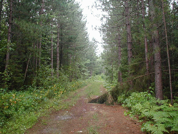
Photo 2: Trail into the north eastern portion of the conservation reserve
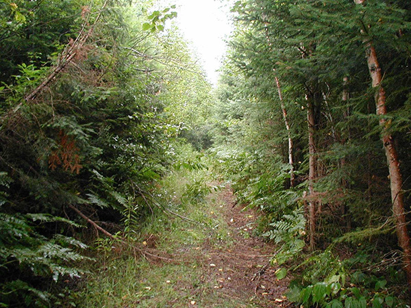
Photo 3: Small marshes located in the northeast corner of the conservation reserve
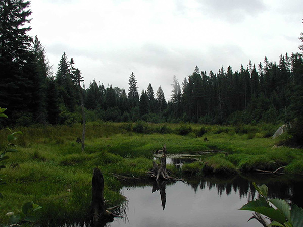
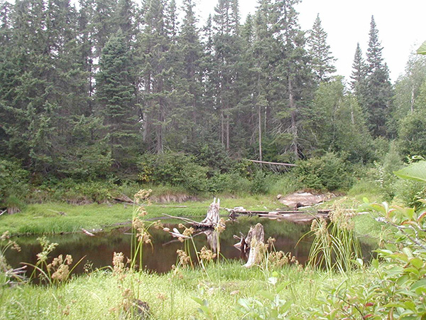
Photo 4: Pond in northern portion of conservation reserve
Appendix 1 - Procedural Guideline B – Land Uses – Test of Compatibility (PL Procedure 3.03.05)
The Conservation Reserve policy provides broad direction with regard to the permitted uses. The policy provides only an indication of the variety of uses that will be considered acceptable in conservation reserves. The only caution is that "any new uses, and commercial activities associated with them, will be considered on a case by case basis, and, they must pass a test of compatibility to be acceptable." What does a 'test of compatibility' mean?
An examination of this must start from the premise of why an area is set aside – specifically, its representative natural heritage values. Criteria are then identified to guide compatibility considerations. These criteria apply to the long-term acceptability of both existing uses and new uses.
-
Conformity to SCI/RMP: SCI describe values for which an area has been set aside and the range of appropriate uses that will be permitted in the area. SCI may also speak to the acceptability of other 'new' uses currently not occurring in the area.
The first 'test' is: "do proposed new land uses and/or commercial activities conform to the direction of the SCI/RMP for the conservation reserve? Would the new use(s) depart from the spirit of appropriate indicator land uses in the SCI/RMP?"
- Impact Assessment: If the proposed use(s) pass test 1 it is important to determine their impact on the area before they are approved. This should include the following:
- Impact on natural heritage values: "will the new use(s) impact any natural values in the area? If so how and to what degree? Is it tolerable?"
- Impact on cultural values: "will the new use(s) impact an historical or archaeological values in the area?"
- Impact on research activities: "will the new use(s) affect research activities in the area?"
- Impact on current uses: "will the new use(s) have any negative impact on the array of current uses?"
- Impact on area administration: "will the new use(s) increase administrative costs and/or complexity?" (For example, the cost of area monitoring, security and enforcement).
- Impact on accommodating the use outside the conservation reserve: "Could the use(s) be accommodated as well or better outside the conservation reserve?"
- Impact on socio-economics of the area: "will the new use(s) affect the community(ies) surrounding the area in a positive or negative way?" (For example, will the new use make an area less remote thereby affecting a local tourism industry that is dependent on the area’s remoteness for its appeal?"
- Impact on area accessibility: "does the new use(s) give someone exclusive rights to the area or a portion of the area to the exclusion of other existing uses?"
The following table provides a guide of indicator uses for the consideration of uses that may be permitted within conservation reserves. For any specific conservation reserve that test of compatibility should be applied to determine which specific uses are acceptable.
Appendix 2 - Public Lands Act Policy (3.03.05) Conservation Reserve Permitted Use Table
Indicator Uses for Conservation Reserves
Recreation
| Permitted Activities | Generic - Existing | Generic - New | (C145) Specific New Uses |
|---|---|---|---|
| Sport fishing | Yes | Yes | Yes |
| Sport hunting | Yes | Yes | Yes |
| Food gathering | Yes | Yes | Yes |
| Facility infrastructure | Maybe | Maybe | Maybe1 |
| Non-trail snowmobiling | Maybe1 | Maybe1 | Maybe2 |
| Non-trail ATV use | Maybe1 | Maybe1 | Maybe2 |
| Rock climbing/caving | Maybe | Maybe | N/A |
| Canoeing/kayaking | Yes | Yes | Yes |
| Motorized boating | Yes | Yes | Yes |
| Picnicking | Yes | Yes | Yes |
| Camping | Maybe | Maybe | Maybe1 |
| Trails | Yes | Maybe | Maybe1 |
| Hiking | Yes | Maybe | Maybe1 |
| X county skiing | Yes | Maybe | Maybe1 |
| Cycling | Yes | Maybe | Maybe1 |
| Horse riding | Yes | Maybe | Maybe1 |
| Snowmobiling | Yes | Maybe | Maybe1 |
Maybe1 = New uses will be considered on a case by case basis provided they do not impact the natural heritage values for which the area was established, and must pass a test of compatibility to be acceptable.
Maybe2 = For retrieval of game only
Science, education & heritage appreciation
| Permitted Activities | Generic - Existing | Generic - New | (C145) Specific New Uses |
|---|---|---|---|
| Research | Yes | Yes | Yes |
| General walking | Yes | Yes | Yes |
| Photography and painting | Yes | Yes | Yes |
| Wildlife viewing | Yes | Yes | Yes |
| Outdoor education/interpretation | Yes | Yes | Yes |
| Collecting | No | No | No |
Commercial activities
| Permitted Activities | Generic - Existing | Generic - New | (C145) Specific New Uses |
|---|---|---|---|
| Food harvesting | Maybe | Maybe | No |
| Fishing | Maybe | Maybe | No |
| Baitfish harvesting | Yes1 | Maybe | Yes |
| Trapping | Yes1 | Maybe | Yes |
| Trap cabins | Yes | No | No |
| Resort-outpost camp | Yes1 | No | No |
| Outfitting-bear management | Yes1 | No | Yes |
| Wild rice harvesting | Yes | Maybe | N/A |
Yes1= Transfer requests will be considered in the context of a Statement of Conservation Interest (SCI) or Resource Management Plan (RMP) for each conservation reserve.
Resource management
| Permitted Activities | Generic - Existing | Generic - New | (C145) Specific New Uses |
|---|---|---|---|
| Inventory monitoring | Yes | Yes | Yes |
| Featured species management | Maybe | Maybe | Maybe |
| Natural systems management | Maybe | Maybe | Maybe |
Industrial activities
| Permitted Activities | Generic - Existing | Generic - New | (C145) Specific New Uses |
|---|---|---|---|
| Timber harvesting | No | No | No |
| Prospecting | No | No | No |
| Mining | No | No | No |
| Hydro generation | No | No | No |
| Energy transmission corridors | Yes | No | No |
| Communications corridors | Yes | No | No |
| Transport corridors | Yes | No | No |
| Resource roads (MNR) | Yes | No | No |
| Land disposition | * | No | No |
| Hunt camps | Yes1 | No | No |
* = Existing dispositions will continue, however, as opportunities arise the Ministry will acquire and/or remove them outside of the conservation reserve.
Yes1 = Transfer requests will be considered in the context of a Statement of Conservation Interest (SCI) or Resource Management Plan (RMP) for each conservation reserve.
Figure 1 - Location Map
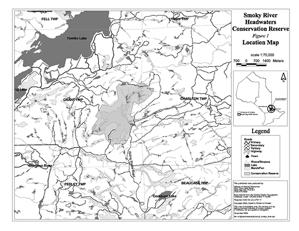
Enlarge Figure 1 - Location Map.
Figure 2 - Forest Values Map

Enlarge Figure 2 - Forest Values Map.
Figure 3 - Recreational Values & Tenure Map