South Grassy Lake Outwash Conservation Reserve Management Statement
This document provides policy direction for the protection, development and management of the South Grassy Lake Outwash Conservation Reserve and its resources.
December 2004
Kirkland Lake District
Ministry of Natural Resources
Approval statement
I am pleased to approve this Statement of Conservation Interest (SCI) for the South Grassy Lake Outwash Conservation Reserve (C1626).
Direction for the establishment, planning and management of conservation reserves is defined under the Public Lands Act, Ontario’s Living Legacy Land Use Strategy and the Crown Land Use Policy Atlas. The specific direction for managing this Conservation Reserve is in the form of a basic SCI, which defines the area to which the plan applies, provides the purpose for which the Conservation Reserve has been proposed, and outlines the Ministry of Natural Resources’ management intent for the protected area. This SCI has been created with input from program specialists within Kirkland Lake District.
This SCI will provide guidance for the management of the South Grassy Lake Outwash Conservation Reserve and the basis for the ongoing monitoring of activities. More detailed direction at this time is not anticipated. Should significant facility development be considered or complex issues arise requiring additional studies, more defined management direction, or special protection measures, then a Reserve Management Plan will be prepared with full public consultation.
Public and Aboriginal consultation occurred regarding this site prior to its regulation during the planning for Ontario’s Living Legacy (MNR, 1999). Furthermore, the public was notified during a 30 day period beginning in January, 2005 concerning a draft of this SCI. Comments from the notification period have been considered in the development of this document.
The South Grassy Lake Outwash Conservation Reserve will be managed under the jurisdiction of the Kirkland Lake/Claybelt Area Supervisor of the Ministry of Natural Resources, Kirkland Lake District.
Plan Author:
Jody Bissett
Land Use Planner
Kirkland Lake District
Approved by:
Corrinne Nelson, District Manager
Date: March 24, 2005
Rob Galloway, Regional Director
Date: April 24, 2005
1.0 Introduction
Ontario’s network of natural heritage areas has been established to protect and conserve areas representative of the diversity of the natural regions in the province, including species, habitats, features and ecological systems which comprise that natural diversity. Protected natural heritage areas are a key component in sustainable management of natural resources. They ensure that representative sites within the larger sustainably managed landscape are permanently retained in their natural state.
Natural Heritage areas are considered to be sensitive, requiring protection from incompatible activities if their values are to endure over time. The Ministry of Natural Resources (MNR) has established conservation reserves as a new tool to offer protection for these areas on public lands, while permitting many traditional public land uses to continue. Such uses include the traditional activities of Aboriginal Peoples.
Ontario’s Living Legacy Land Use Strategy (OLL LUS) (MNR, 1999) and the Crown Land Use Policy Atlas (2002) set the direction for the administration and management of parks and protected areas on Crown lands within three planning regions; the Boreal West, Boreal East and Great Lakes - St. Lawrence. This strategy’s natural heritage objectives include protection of natural and cultural heritage values and the provision of opportunities for outdoor recreation, heritage appreciation and tourism (MNR, 1999).
Protected areas designated within the OLL LUS have been selected based on their representation of the spectrum of the province’s ecosystems and natural features including both biological and geological features, while minimizing impacts on other land uses. Representation was described using landform and vegetation combinations based on Hill’s (1959) site district concept.
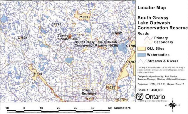
The South Grassy Lake Outwash Conservation Reserve (C1626) is a 425 ha parcel of Crown land that is situated approximately 17 kilometers east of the Town of Kirkland Lake (Figure 1.0). It is found within McElroy and Hearst Townships, in the Kirkland Lake District within the MNR’s Northeast Region. Access to the Conservation Reserve is limited to two tertiary roads located in the southwest and northwest and a snowmobile/ATV trail bisecting the site. Boat access is possible from Grassy Lake as well. Currently, 267 of the 425 hectares within this Conservation Reserve is designated as a Forest Reserve (FR). Policies for Forest Reserves are similar to policies for new Conservation Reserves, except that mining and related access are allowed. Due to the large size of this FR and as a result of the mining tenure disentanglement initiative to move protected areas geography off active mining fabric, opportunity for replacement lands will be entertained to the south of the existing Conservation Reserve. The South Grassy Lake Outwash Conservation Reserve will be managed under a Statement of Conservation Interest (SCI).
SCI documents are the minimum level of management direction established for any conservation reserve and generally are brief management plans. This SCI will govern the lands and waters within the regulated boundary of the South Grassy Lake Outwash Conservation Reserve. However, to ensure MNR protection objectives are fully met within this Conservation Reserve, management of the surrounding landscape and related activities should consider the site’s objectives and heritage values. In addition, it is the intent of SCI’s to create public awareness that will promote responsible stewardship of protected areas and surrounding lands. The MNR will work together with management partners such as Ontario Parks, industry and local governments to pursue and advance sound environmental, economic and social strategies and policies related to the protection of conservation reserves and provincial parks.
The purpose of this SCI is to identify and describe the values of South Grassy Lake Outwash Conservation Reserve and outline the Ministry’s management intent for the Conservation Reserve. The management direction will protect the site’s natural heritage values and demonstrate its compatibility within the larger sustainable landscape. This direction will comply with land use intent as stated by the OLL Land Use Strategy (MNR, 1999).
Figure 1.0 South Grassy Lake Outwash Conservation Reserve
Enlarge Figure 1.0 South Grassy Lake Outwash Conservation Reserve
2.0 Goals and objectives
2.1 Goal of Statement of Conservation Interest
The goal of this SCI is to describe and protect natural heritage values on public lands while permitting compatible land use strategies. It is also intended to guide the management decisions that will ensure the Grassy Lake Outwash Conservation Reserve will meet this goal through both short and long-term objectives.
2.2 Objectives of SCI
2.2.1 Short term objectives
The short-term objectives are to identify the State of Resource in terms of natural heritage values and current land use activities for the South Grassy Lake Outwash Conservation Reserve. A priority will be placed on the protection of the site’s natural values via specific guidelines, strategies and prescriptions detailed in this plan. Finally, legislated planning requirements will be met; in particular SCI development will occur within three years of regulation.
2.2.2 Long term objectives
The long-term objectives are to establish representative targets (e.g. future forest conditions) and validate the site as a potential scientific benchmark. To ensure protection of natural and cultural heritage features and values, this SCI will establish an evaluation process to address future new uses and commercial activities associated with them (e.g. Test of Compatibility Procedural Guideline B in Conservation Reserve Policy PL 3.03.05, Appendix #4). Finally, this SCI will identify research, client services and marketing strategies associated with the South Grassy Lake Outwash Conservation Reserve.
3.0 Management planning
3.1 Planning area
The planning area for this site will consist of the area within the regulated boundary for the South Grassy Lake Outwash Conservation Reserve (Locator Map, Appendix #7). This landbase will form the area directly influenced by this Statement of Conservation Interest. The SCI will recognize the protection of values within the planning area; however, to fully protect values within the Conservation Reserve, the lands beyond the regulated boundary may require additional consideration within larger land use or resource management plans. Nevertheless, any strategies noted within this plan related to the site’s boundary or beyond will need to be presented for consideration within a larger planning context.
3.2 Management planning context
The South Grassy Lake Outwash Conservation Reserve was first designated as a candidate conservation reserve by MNR in the OLL Proposed Land Use Strategy (MNR March, 1999) and ultimately as conservation reserve in the final OLL Land Use Strategy (MNR, 1999). The site was regulated with the filing of Ontario Regulation number 86/01 made under the Public Lands Act on April 6th, 2001. Management and planning direction for this site will follow the OLL LUS (MNR, 1999) and this Statement of Conservation Interest. The area encompassed by this site has been removed from the Timiskaming Forest Alliance Inc. Sustainable Forest License (SFL) landbase.
By regulation this Conservation Reserve cannot be used for commercial forest harvest, mining or hydroelectric power development (MNR, 1999). Existing permitted uses within the CR may continue such as; fishing, hunting and trapping. This SCI document and future management of the site will resolve conflicts regarding incompatibility between uses and to ensure that identified values are adequately protected.
This SCI will only address known issues or current proposals with respect to permitted uses or potential economic opportunities brought forward to the Kirkland Lake District Manager during this planning stage. However, in terms of approving future permitted uses and/or development(s), there are established mechanisms in place to address such proposals. Any future proposals will be reviewed using the Procedural Guideline B - Land Uses - Test of Compatibility Public Lands Act Policy PL 3.03.05 (MNR 1997, Appendix #4) or other standard MNR environmental screening processes.
Consideration of proposals pertaining to cultural resources may be screened through ‘Conserving a Future for our Past: Archaeology, Land Use Planning & Development in Ontario’, Section 3 (MCzCR, 1997), or in processes such as that used by MNR to establish Area of Concern (AOC) descriptions and prescriptions for cultural heritage resources within Forest Management Plans (FMPs).
These planning tools will help refine the review process once the proposal satisfies the direction and intent of the Public Lands Act, associated policies and this SCI.
3.3 Planning process
Once a conservation reserve is passed into regulation, the level of management planning required to fulfill the protection targets must be determined. There are two policy documents involved. A Statement of Conservation Interest (SCI) is the minimal requirement for providing planning direction. A Resource Management Plan (RMP) is written when more complex issues arise, such as when several conflicting demands are placed on the resources. The guidelines for the preparation of these documents are outlined in Procedural Guideline A Resource Management Planning (Conservation Reserves Procedure PL 3.03.05 Public Lands Act). The appropriate plan must be completed within three years of the conservation reserve’s regulation date.
For current planning purposes, the South Grassy Lake Outwash Conservation Reserve will be managed under the auspices of a basic Statement of Conservation Interest. Interested parties from both the private and public sector were consulted during the OLL implementation process, from candidate conservation reserve to regulation. The public was widely consulted during the regulation process and further consultation is not required at this time (Appendix #1). In addition, a public notification of a draft of this SCI document occurred for a period of 30 days commencing January 21, 2005 (Appendix #2).
The revised SCI was reviewed by the Kirkland Lake District Manager (DM). Upon approval by the DM the SCI was presented to the Northeast Regional Director (RD) for final approval.
Following RD approval, interested public, user groups and shareholders were notified that the Statement of Conservation Interest for the South Grassy Lake Outwash Conservation Reserve was approved. Public consultation will be solicited as part of any future reviews of land use proposals that would require new decisions to be made. In addition, any future proposal and/or any new, significant management direction considered may be published on the Environmental Bill of Rights Registry (EBR).
The SCI is a management document that will provide background information, identify values to be protected and establish management guidelines for use in the administration of the Conservation Reserve.
The implementation of the SCI will be the mandate of the MNR at the District level; however, associations with various partners may be sought to assist in the delivery. This SCI is a working document, and as a result, it may be necessary to make revisions to it from time to time.
4.0 Background information
4.1 Location and site description
4.1.1 Location
The South Grassy Lake Outwash Conservation Reserve is located approximately 17 km east of Kirkland Lake, within McElroy and Hearst Townships in the District of Timiskaming (Locator Map, Appendix #7). The Conservation Reserve is found within the Kirkland Lake eco-district 3E-3 (Hills 1959; Crins & Uhlig 2000) of the Lake Abitibi eco-region 3E. The following table summarizes the location and provides administrative details of the South Grassy Lake Outwash Conservation Reserve.
Table 1.0: Location data
Table 1.0 reformatted into a list
- Name: South Grassy Lake Outwash Conservation Reserve
- Eco-Region & Eco-District (Hills; Crins & Uhlig): 3E-6 (Kirkland Lake) eco-district of the 3E (Lake Abitibi) eco-region
- MNR administrative region/District area: Northeast Region/Kirkland Lake District in the Kirkland Lake/Claybelt Area
- Total area: 425 ha (includes 267 ha forest reserve)
- UTM co-ordinates: 794715 W, 480458 N
- Nearest town/municipality: Town of Larder Lake
- Township(s): McElroy & Herst
- OBM numbers: 590053300
- Topographical map name/number: Larder Lake 32D/4
- Wildlife management unit: 28
- Forest management unit: Timiskaming Forest
4.1.2 Site description
4.1.2.1. Physical description
The Kirkland Lake eco-district is characterized by moderately broken plains of granitic and low-base bedrock, generally covered by a thin layer of granitic and low-base sand and silty sand. Several trains of glaciofluvial sand and gravel occur (Hills 1959 and Poser 1992). The eco-region landform is characterized by flat to gently rolling, glacial clay and sandplain with local extensive peatlands and wetlands, broken throughout by glacial features such as moraines, eskers and kame/kettle complexes with Canadian Shield exposures. Regional vegetation includes stands of spruce, poplar, and birch on fresh sites on moderately sloping terrain. White pine and red pine occur on sand ridges. American elm and white cedar are found only in protected areas. The forest climate type is mid-humid, mid-boreal (Hills 1959).
Aerial reconnaissance and photo interpretation by Rik Kristjansson, an OLL Geologist, (2004) determined a total of six surficial geology landforms on the site, bedrock-drift complex being the most dominant (Map 1a, Appendix #8). However, it is important to note that Kristjansson did not analyze the eastern half of the Conservation Reserve which is currently designated as a Forest Reserve. Bedrock is the dominant landform in the Conservation Reserve according to the Quaternary geology of Ontario coverage (Map 1b, Appendix #8). Glaciolacustrine deposits are also present in the central area, far east and in slivers near the northwest corner of the Conservation Reserve. These geological are commonly encountered within the surrounding region and are considered to be of local significance. For more detailed information see the Earth Science Checksheet (Appendix #9).
The South Grassy Lake Outwash Conservation Reserve is located in the Missinaibi-Cabonga section of the Boreal Forest Region (Rowe, 1972). This section extends along the height of land in central Ontario, the bulk of the forest is boreal but scattered individuals or isolated patches of species from the Great Lakes-St. Lawrence Forest (GLSL) can be found.
The predominant forest is mixed in character consisting of an association of balsam fir (Bf), black spruce (Sb) and white birch (Bw) with scattered white spruce (Sw) and trembling aspen (Po). Jack pine (Pj) is typically found on sand terraces and can be associated with Sb on poor, rocky soils. On wet organic soils black spruce is usually found with tamarack (larch) and on other lowlands with cedar. The topography is rolling with numerous flats along the rivers and lake sides. The underlying granitic, volcanic and sedimentary rocks are of Precambrian age, and from them the shallow till overburden has inherited varying degrees. In the central and western portions the till overburden is richest and rocks such as greenstone occur.
4.2 Administrative description
The legal boundaries of the South Grassy Lake Outwash Conservation Reserve were filed on January 12th, 2001 with the Office of the Surveyor General, Ministry of Natural Resources in Peterborough, Ontario. This site was passed into regulation on April 6th, 2001.
4.3 History of site
The vegetation and forest cover within this CR provide protective cover and food for many species of large and small mammals, suggesting historical use for hunting and trapping. These activities continue to the present day with two traplines (KL 077 & KL 071) and two Bear Management Areas (KL-28-020 & KL-28-023) within Conservation Reserve boundaries (Map 3a, Appendix #8). The lakes, rivers and wetlands within the site provide fishing and baitfish harvesting opportunities. Currently both McElroy and Hearst Townships have assigned baitfish harvesting licenses.
Much of the regulated Conservation Reserve was harvested in the early 1980’s, resulting in the large stand of white spruce conifer mix aged 0-29 years (Map 2c, Appendix #8). Mining is another activity which occurred on this site as evidenced by an abandoned mine shaft in the eastern section of the site.
4.4 Inventories
The following table indicates the natural heritage inventories which have occurred within this site.
Table 2.0 Inventory data status
| Type of inventory | Method | Date | Report author(s) |
|---|---|---|---|
| Life science | Aerial reconnaissance | September 2003 | W. Cudmore, S. Longyear; OMNR |
| Earth science | Aerial reconnaissance & aerial photo interpretation | October 2004 | R. Kristjansson |
| Recreation | Aerial & ground reconnaissance | June/September 2003 | R. Gordon; OMNR |
5.0 State of the resource
Representation:
The South Grassy Lake Outwash Conservation Reserve contains 11 forest communities, as classified by the Forest Resource Inventory (FRI) (Map 2a, Appendix #8). The dominate forest communities are; poplar mixedwood (34.7% of the total area), white spruce dominant conifer (32.2%) and brush/alder (10.3%). The poplar mixedwood is concentrated in the eastern half and the white spruce dominant conifer in the western half.
During the aerial reconnaissance survey (2003), Nicholson observed three main differences from the FRI data. Poplar mixedwood stands in the east had black spruce as a subdominant layer, which will most likely be the next cohort, the treed muskeg in the southeast is actually a fully stocked, pole sized, immature larch stand and the white spruce dominant conifer stand in the west contains larch and jack pine as well.
Stocking is defined as an expression of the adequacy of tree cover of an area, or how well trees are distributed across the site (OMNR, 2003). Stocking is usually expressed as a percent value, the higher the percent the more even the distribution pattern. In this site, distribution is mixed, ranging from 0 to 99%. Low stocking patterns correspond to harvesting practices and succession. Harvesting took place in the early 1980’s on the west side of the Conservation Reserve and is now dominated by white spruce dominant conifer stands, stocking in this area ranges from 41-60%. The poplar mixedwood in the east half has a lower stocking range at 1-40% and 41-60%, due to succession. The white spruce mixedwood is 1-40% stocked while the black spruce predominant conifer and poplar hardwood mixed are both 61-80% stocked. The cedar predominant conifer stand in the southeast is 81-99% stocked. No stocking took place in the Sb pure stand as it was classified as a barren and scattered stand (Map 2b, Appendix #8).
There is a large range in the age of forest communities, from seven years right up to 119 years in the poplar mixedwood stand within the Forest Reserve. This range is associated with past harvest blocks. Supplementary aerial photography (SAP) from 1980 shows that approximately 2⁄3rds of the CR was harvested around this time, 2003 SAP shows the stands regenerating nicely. The harvested area was approximately 137 ha, was likely planted and now contains a 25 year old stand containing 90% white spruce (Sw) and 10% jack pine (Pj) (Austin 2004). The other forest communities are more mature stands. The black spruce (Sb) predominant conifer and poplar (Po) hardwood mixed stands are 60-89 years of age, the two communities in the center (Sw mixedwood and Sb/Po true mixed) are 90-119 and the cedar (Ce) dominant and predominant conifer communities in the southeast are both aged at 60-89 years.
The Forest Communities were re-defined as Standard Forest Units (SFU’s), a classification system commonly used in the OMNR’s Northeast Region. The 11 forest communities were re-classified into six SFU’s, the dominant SFU’s are; SF1 (spruce fir) (32.2% of the total area), MW2 (spruce fir mixed) (28.1%) and P01 (poplar) (17.2%). Other SFU’s include SB1 (black spruce lowland) (3.4%), LC1 (lowland conifer) (2.8%) and BW1 (birch poplar) (0.5%). Using Bridge et al. (2000) definitions for candidate old growth, there is an extensive MW2 old growth stand in the central and eastern area of the site and an old growth P01 stand located in the eastern section of the Forest Reserve (Map 5, Appendix #8).
There are a total of eight wetland types in the South Grassy Lake Outwash Conservation Reserve (Map 3b, Appendix #8). According to Nicholson’s (2003) observations during the aerial reconnaissance survey, cattail marsh and tall willow thicket swamp dominate in the area south of Grassy Lake. Along the northwest corner of the site there is a tall shrub shore fen and south of it an alder thicket swamp. Meadow marsh surrounds the stream running up the middle of the site and an alder thick swamp follows a creek near the snowmobile trail, in the forest reserve section of the site. In the southeast corner there is a small section of shore fen and further east a larger section of beaver marsh/meadow marsh. According to FRI, wetlands account for 14.3% of the total area (excluding conifer swamp), a high percentage of brush/alder occur within this site (10.3%). The South Grassy Lake Outwash Conservation Reserve is located within the tertiary watershed 2JC of the Ottawa River major basin (OMNR 2004).
Quality of representation:
The quality of the representation or the current characteristics of the natural features found within a conservation reserve are as important as the overall representative features that are being protected. A number of factors are considered when evaluating a site and they include the following criteria: diversity, condition, ecological factors, special features and current land use activities. Each of these factors must be considered when examining a conservation reserve.
a) Diversity:
Diversity is a measure of the site’s life and earth science heterogeneity. It is based on the number and range (variety) of the natural landscape features and landforms of earth science values and the richness and evenness of the life science components. The diversity rating is based on the size of the conservation reserve versus the number of landform:vegetation (L:V) combinations, a criteria developed by J. Thompson & J. Noordhof (2003).
Kristjansson (2004) studied aerial photography for the regulated section of this Conservation Reserve (i.e. not the Forest Reserve). According to his interpretation there are six surficial geology units in the site, four SFU’s and one wetland. This results in a total of 21 different L:V combinations, giving this site a diversity rating of medium. After removing any L:V combinations which cover less than 1% of the Conservation Reserve, a total of 12 L:V combinations were left, reducing the diversity rating to low. According to Kristjansson the three dominant L:V combinations are; bedrock drift complex with spruce fir mixed (43.3% of the total area), glasiolacustrine deposits with spruce fir mixed (18%) and organic deposits with brush/alder (9.5%).
According to the Quaternary Geology of Ontario (QGO) coverage, bedrock is the major landform throughout the Conservation Reserve (including the Forest Reserve), with glaciolacustrine deposits as the secondary landform (Map 1b, Appendix #8). This differed from Kristjansson (2004) interpretation, but still resulted in a low diversity rating for the site (14 L:V combinations). However if wetlands are included, there are six different wetland types on glaciolacustrine deposits and eight wetlands are on bedrock (Map 3b, Map1b, Appendix #8). Including these the total L:V combination increases to a total of 24 L:V combinations, resulting in a diversity rating of medium. Due to a shift in the layer as a result of using different projections and changes in scale, the bedrock landform is actually located throughout the eastern part of the site and in half of the western side and the glaciolacustrine deposits run along·the southern shore of Grassy Lake. This was verified on the Northern Ontario Engineering Geology Terrain Study (NOEGTS) map, and verified by the aerial reconnaissance survey and Kristjansson’s comments on the landforms.
The gap analysis included both the CR and the FR and had a total of nine L:V combinations, including young spruce on moderately broken outwash deposits and moderately broken bedrock are the primary representative features (Ritchie et al. 1998). The other L:V combination’s present are open muskeg, poplar, treed muskeg and white birch on moderately broken outwash deposits and cedar, open muskeg and white birch on moderately broken bedrock.
Wetlands add some diversity to the site, which include the tall willow thicket swamp and shore fen and bulrush marsh along Grassy Lake southern shoreline. Another wetland that adds diversity to the site is the meadow marsh, located centrally in the site. As seen in Map 3b, Appendix #8, the greatest concentration of wetlands are along the southeastern boundary.
The landform vegetation combinations from Kristjansson’s analysis were determined to be the most accurate and therefore were when determining total L:V combinations present and final diversity rating.
Evenness refers to the proportion of each cover type and its measured area. The evenness in the CR is strongly skewed to two forest communities; SF1 (32.2% of the total area) and MW2 (28.1% of the total area) together account for 60.3% of the site. The third most dominate cover type is P01 which covers 17.2% of the area in the Conservation Reserve. Many of the forest communities are immature due to the harvesting which took place within the area. There is one mature P01 stand and the MW2 and P01 candidate old growth areas. There is little dispersion on the site as each of the SFU’s has their own defined area.
b) Condition
Condition refers to the amount of disturbance that the site has experienced to date and includes both human and natural disturbances. Overall the disturbance rating for this site would be high because almost half the site has been harvested. Other man-made disturbances are the snowmobile and ATV trail, with a well maintained ridge, that runs through the eastern part of the site. A thorough examination of current Satellite Aerial Photographs (2003) shows a network of roads in the western part of the site that were originally used for wood hauling; likely they are presently used by ATV traffic (Austin 2004). Also, there is an abandoned mine shaft in the eastern section of the site. Other disturbing agents located outside of the site include a recent harvest adjacent to the southeast boundaries of Grassy Lake and a boat launch on the west side of Grassy Lake. The gap analysis (1998) also mentions aggregate pits in the site although these were not observed during ground reconnaissance and are not depicted on the maps.
Natural disturbances within the 3E eco-region include a massive spruce budworm infestation from 1968 to 1995 (OMNR 2003 (2), forest tent caterpillar and windthrow damage and fire. However, the natural disturbance rating for this site in particular is low.
c) Ecological factors
Wherever possible, a site’s boundaries should be created to include the greatest diversity of life and earth science features to provide the maximum ecological integrity. It should be ecologically self-contained, bounded by natural features and include adequate area to protect the core ecosystems from adjacent land use activities (OMNR 1992). This site has 3 types of boundaries, cultural, biological and vectored. Biological boundaries dominate the site and include the northwest section which follows Grassy Lakes southern shorelines and many areas in the south, east and west which follow creek contours. Cultural boundaries include one in the northeast that follows the McElroy and Hearst Township line, another in the south that follows the snowmobile trail, another which follows a tertiary trail and another around patent land southeast and west of Grassy Lake. The remaining boundaries are all vectored along patent land.
Comparing the different boundary lines (History Map, Appendix #8) it is clear that white spruce dominant conifer and poplar mixedwood are the two forest communities that were captured in the gap analysis. The north end of the regulated Conservation Reserve offers a high level of protection for the Sw community. In the southwestern section there are no forest communities, wetlands or landforms present to protect the Sw dominant conifer stands from adjacent land use activities; therefore if an addition is made to the CR in the future it would be logical to add an area south of the western area to increase protection (Ecological Considerations Map, Appendix #8). The regulated boundary line adds diversity since a greater number of wetland and forest communities are included.
Consideration is being given to including approximately 200 ha south of the regulated section of the site. The reason behind this is that due to the high number of active mining claims and leases the Forest Reserve section may be removed from the site. If this addition is made there will be an increase in the core habitat area being protected. A second ecological consideration should be given to the southeastern section of the site. Currently the boundary follows the creek north to the snowmobile/ATV trail, another option would be for the boundary to extend south and follow the creek system, increasing the number of biological boundaries. (Ecological Consideration Map, Appendix #8).
Currently there are no minimum size standards for conservation reserves under different landscape conditions. However, a minimum size standard of 2000 ha has been established for natural environment parks by Ontario Parks (OMNR 1992). This minimum standard was considered necessary to protect representative landscapes as well as to allow for low intensity recreational activities. Although the South Grassy Lake Outwash Conservation Reserve does not meet the suggested size standard, it is still well protected. There are only two tertiary roads into the site and the one snowmobile/ATV trail that runs diagonally through the east half, which promotes recreational activity.
d) Special features
The glaciolacustrine deposits with silty, fine sand and glaciolacustrine plain have been reworked by the wind and as a result unique sand dunes have formed on the site. The two old growth stands of MW2 and P01 are special as they cover a large area of the Conservation Reserve, predominately in the Forest Reserve section.
e) Current land use activities
Hunting, trapping, snowmobiling, canoeing, fishing and ATVing are all activities which take place within the South Grassy Lake Outwash Conservation Reserve.
There are a number of hunting stands and camps located throughout the site and in the neighboring area. Abundant moose feeding and calving areas support a healthy moose population. The surrounding mixed forest area with berries and vegetation, as well as bear signs and scat suggest good habitat for black bear. A hunt guiding outpost, located just outside the Conservation Reserve, promotes the fall hunt and receives an allocation of hunting tags from OMBAAC (Ontario Moose and Bear Allocation Advisory Committee) as a tourist outfitter shareholder. Other game animals hunted within or near the site are rabbit and hare, grouse, waterfowl and possibly deer. Hunters were observed within the site during the aerial recreation inventory. Two established trapline areas and bear management areas overlap the South Grassy Lake Outwash Conservation Reserve (Map 3a, Appendix #8).
The Ontario Recreational Canoeing Association (ORCA) has identified the Miseama River system, of which Grassy Lake is a part, as an existing canoeing destination. The Miseama River and Grassy Lake are picturesque, calm and well suited for canoe travel. Recorded data concerning the nature of fishing opportunities within Grassy Lake and Misema waterway is limited. Grassy Lake itself is a cool water, shallow lake that contains northern pike and walleye. Ice fishing may also occur here.
Trails exist within the Forest Reserve portion of the Conservation Reserve and there is an extensive trail system to the south of the site, which appears to be used by people driving ATVs. Within the regulated half of the Conservation Reserve there are no visible trails.
The mainline snowmobile trail which connects Larder Lake and Englehart runs through the Forest Reserve and along part of the southern boundary of the Conservation Reserve. Due to the heavy forest on either side of the established trail, off-trail snowmobile use is probably rare.
Summary:
South Grassy Lake Outwash Conservation Reserve is a protected landform comprised of bedrock and sections of glaciolacustrine deposits with several wetlands concentrated in the northwest, middle and southeast. Based on Kristjansson’s (2004) interpretation six surficial geology landforms exist on the regulated portion of the site (Map, 1a, Appendix #8). The Conservation Reserve is dominated by poplar mixedwood, white spruce dominant conifer, brush/alder and white spruce mixedwood forest communities. The 11 forest communities were re-classified into six Standard Forest Units (SFU’s). The dominant SFU’s are SF1 (spruce fir), MW2 (spruce fir mixed) and P01 (poplar). According to the OLL Land Use Strategy (OMNR 1999) young spruce on moderately broken outwash deposits and moderately broken bedrock are the primary representative features of the site. Comparing this to the FRI and Kristjansson’s (2004) surficial geology interpretation the vegetation has been protected on over half of the site with bedrock-drift, therefore it is a provincially significant site.
Natural heritage representative features
Kristjansson’s Landform - Vegetation (L:V) combinations
Table 3.0: Vegetation:Landform Types
Gray shading [not indicated in original document] indicates these areas account for >1% of area in the regulated portion of the CR
Table 3.0 reformatted into a list
- Organic deposits:Upland Spruce & Fir (SF1)
- Organic deposits:Lowland Black Spruce (SB1)
- Organic deposits:Poplar & Birch with Spruce (MW2)
- Organic deposits:Brush/Alder
- Alluvial deposits:Upland Spruce & Fir (SF1)
- Alluvial deposits:Lowland Black Spruce (SB1)
- Alluvial deposits:Brush/Alder
- Bedrock-drift complex (drift cover is discontinuous):Upland Spruce & Fir (SF1)
- Bedrock-drift complex (drift cover is discontinuous):Lowland Black Spruce (SB1)
- Bedrock-drift complex (drift cover is discontinuous):Poplar & Birch with Spruce (MW2)
- Bedrock-drift complex (drift cover is discontinuous):Brush/Alder
- Bedrock-drift complex / Glaciolacustrine deposits:Upland Spruce & Fir (SF1)
- Bedrock-drift complex / Glaciolacustrine deposits:Poplar & Birch with Spruce (MW2)
- Bedrock-drift complex / Glaciolacustrine deposits:Brush/Alder
- Glaciolacustrine deposits (silty, fine sand):Upland Spruce & Fir (SF1)
- Glaciolacustrine deposits (silty, fine sand):Lowland Black Spruce (SB1)
- Glaciolacustrine deposits (silty, fine sand):Brush/Alder
- Glaciolacustrine deposits (silt & clay):Upland Spruce & Fir (SF1)
- Glaciolacustrine deposits (silt & clay):Poplar (P01)
- Glaciolacustrine deposits (silt & clay):Poplar & Birch with Spruce (MW2)
- Glaciolacustrine deposits (silt & clay):Brush/Alder
Forest Resource Inventory (FRI) Data
- Dominant species, wetlands, and depleted areas
- See Forest Species Composition Map (Map 2a, Appendix #8)
5.1 Social/economic interest in area
a) Linkage to local communities:
The South Grassy Lake Outwash Conservation Reserve is a 425 hectare parcel of Crown land that is situated approximately 18 km southeast of Kirkland Lake, and 4 km southwest of the Town of Larder Lake. This site is found within McElroy and Hearst Townships in the District of Timiskaming (Locator Map, Appendix #7).
Citizens from local communities use this site to trap and hunt, it is also within the Beaverhouse Aboriginal Community’s Area of Interest. ATV and snowmobile riding, fishing and canoeing are activities which both local citizens and tourists can partake in.
b) Heritage estate contributions
The South Grassy Lake Outwash Conservation Reserve contributes to the province’s parks and protected areas system through its regulation, representation and the long-term management of natural heritage values. By allocating these lands to the parks and protected areas system, the province has ensured a certain level of permanence by distinguishing the site and its values from the broader general use or more extensively managed landscape. In addition, its natural features are, and will continue to be, available for present and future generations to enjoy and explore.
c) Aboriginal groups
This Conservation Reserve falls within the Beaverhouse Aboriginal Community’s Area of Interest. Traditional Aboriginal activities will not be affected by the regulation of this Conservation Reserve.
d) Mining interests
Currently over half of Grassy Lake Outwash Conservation Reserve, 269 of the 425 hectares, is designated as a Forest Reserve. Within this area there are 17 active mining claims. Forest Reserves are areas where protection of natural heritage and special landscapes are priorities, but some resource use can take place with appropriate conditions. The intention is that either these lands will be added to the Conservation Reserve as claims and leases are retired through normal processes, or the Forest Reserve will be removed from the site and areas to the sought of the regulated portion will be added. On the regulated 156 ha, mining and surface rights have been withdrawn from staking under the Mining Act (RSO 1990 Chapter M.14).
e) Forest and fire management history:
This site has been affected by management activities over the last 20-30 years. Approximately 137 hectares was cut in 1980, and has regenerated as a white spruce conifer mixed stand, approximately 90% white spruce, 10% jack pine (Austin 2004). This stand is clearly visible on the Age Distribution Map classified as 0-29 years and was likely planted post-harvest (Map 2c, Appendix #8). A recent harvest block, within the past five years, exists west of the Conservation Reserve, in McElroy township.
This site has no recent burned areas within its boundary.
5.2 Natural heritage stewardship
Analysis by Kristjansson (2004) of the life science targets based on landform:vegetation combinations, determined 21 different landform:vegetation (L:V) combinations. This results in a medium diversity rating for the site. However, after removing areas which account for less than 1% of the total area, there were 12 L:V combinations, reducing the diversity rating to low. According to Kristiansson, the three dominant L:V combinations are spruce fir on bedrock-drift complex/glaciolacustrine deposits, spruce fir on glaciolacustrine deposits (silty, fine sand), and brush/alder on organic deposits.
This Conservation Reserve is strongly skewed towards spruce fir (SF1), spruce fir mixed (MW2) and poplar (P01), these top three communities account for 77.5% of the Conservation Reserve. The forest communities are mostly immature, except for the mature P01 stand. The immature stands are representative of the harvesting that took place throughout the site. Using Bridge et al. (2000) definitions for candidate old growth there is an extensive area of old growth MW2 and P01 in the Forest Reserve portion of the Conservation Reserve (Map 5, Appendix #8).
5.3 Fish and wildlife
Grassy Lake is not found directly within the Conservation Reserve but it does make up the northern boundary of the regulated portion of the site. Grassy lake is accessible by a private road from Hwy 66 and is know to be a fishing destination for locals. Grassy Lake is a cool water shallow lake that contains northern pike and walleye combination and possibly other sport fish. Misema River, which Grassy Lake drains into, contains brook trout (N.E Ont. Sport Fishing Atlas, 1993). This lake is utilized during hunting seasons for waterfowl and moose.
Through site visits and observation of vegetation, forest cover, animal tracks and droppings moose and black bear are found within the Conservation Reserve boundaries. A number of small mammals and furbearers, were observed during ground inventory work. Marten, fox, fisher, beaver, mink, otter, muskrat, red squirrel and rabbit as well as woodcock and grouse all inhabit the area encompassed by the Conservation and Forest Reserve.
5.4 Cultural heritage stewardship
A detailed assessment of cultural resources has not been carried out. A high potential for cultural values exists along the Misema River, the west and north boundaries of the site, however to date no cultural, historic or archeological features have been discovered within the Conservation Reserve boundaries.
5.5 Land use/existing development
This Conservation Reserve is situated entirely on Crown Land and is unencumbered by any patented land. It does however; overlap 17 active mining claims, resulting in the eastern half of the proposed CR to be designated as a Forest Reserve (Land Use Designation 7.2.3). Policies for Forest Reserves are similar to the policies for new Conservation Reserves, except that mining and relates access will be allowed in a Forest Reserve. This area was initially identified for inclusion in the Conservation Reserve but under detailed examination existing mining leases and claims were discovered.
5.6 Commercial land use
Present commercial land use activities overlapping this site are two bear management areas (KL-28-020, KL-28-023) and two trap lines (KL077, KL071) (Map 3z, Appendix #8). KL-28-020 covers almost the entire site with only a tiny portion of KL-28-023, just south of Grassy Lake, within Conservation Reserve boundaries. KL077 is the dominant trapline in the site, covering all of the regulated Conservation Reserve and the majority of the Forest Reserve. A triangular section of KL071 is present in the northeast corner of the Forest Reserve. Both McElroy and Hearst townships have baitfish harvesting licenses assigned to them.
5.7 Tourism/recreation use/opportunities
South Grassy Lake Outwash Conservation Reserve contains large and small mammals, mixed forests, and aquatic flora and fauna, all which provide recreational opportunities. Existing recreational uses in this site and immediately surrounding the site include trapping, hunting, canoeing and possibly fishing, as well as ATV and snowmobile use. There is also potential for activities such as bird watching, berry picking, hiking and nature study.
For a more detailed report and summary of the recreational use and potential, refer to the Recreational Inventory Report (Appendix #3).
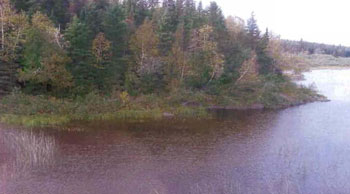
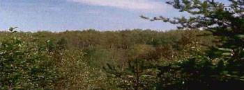
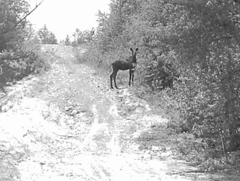
Photo taken during Aerial Reconnaissance Survey, Sept. 2003
5.8 Client services
Currently, visitor services are limited to responding to inquiries regarding access, natural heritage features and boundaries. No formal information or interpretive facilities currently exist within the South Grassy Lake Outwash Conservation Reserve. Other client services include providing clients with maps, fact sheets, and other information gathered on the area, such as the Earth and Life Science Reports and the Recreational Inventory Report. Inquiries for information pertaining to this site should be directed to the Kirkland Lake District Office.
6.0 Management guidelines
6.1 Management planning strategies
The land use intent outlined in the OLL LUS (MNR, 1999) and the Crown Land Use Policy Atlas provide context and direction for land use, resource management, and operational planning activities on Crown Land in the planning area and within OLL site boundaries. Commitments identified in the OLL LUS and current legislation (Policy 3.03.05 PLA) forms the basis for land use within the South Grassy Lake Outwash Conservation Reserve. Management strategies for these uses must consider the short and long-term objectives for the Conservation Reserve. For up to date information on permitted uses refer to the Crown Land Use Atlas (Appendix #6).
Proposed new uses and development will be reviewed on a case-by-case basis. A Test of Compatibility (Procedural Guideline B - Land Uses (PL 3.30.05)) must be completed before proposals can be accepted. In all cases, ensuring that the natural values of the Conservation Reserve are not negatively affected by current and future activities will be the priority. Therefore any application for new specific uses will be carefully studied and reviewed.
Forest reserves
Under the OLL LUS (1999), mining and related access will be allowed in Forest Reserves. If activities are proposed that could negatively influence the natural heritage values within the Forest Reserve and/or the Conservation Reserve, the Kirkland Lake District will work with the proponent to identify and mitigate potential mining or natural heritage concerns. Mining will not occur in any portion of regulated conservation reserve boundaries.
6.2 “State of the Resource” management strategies
The development of this SCI and the long term management and protection of the South Grassy Lake Outwash Conservation Reserve will be under the direction of the MNR’s Kirkland Lake District, Kirkland Lake/Claybelt Area Supervisor. The following management strategies have been created to achieve the goal and objectives stated earlier in this management document.
Natural heritage stewardship
The management intent for the South Grassy Lake Outwash Conservation Reserve is to allow for natural ecosystems, processes and features to operate undisturbed with minimal human interference while providing educational, recreational and potentially research activities. Forest ecosystem renewal will only be entertained via a separate Vegetation Management Plan. As part of any future Vegetation Management Plan, the site and its Site District will be reevaluated with respect to their known landform/vegetation features to determine if the past harvested areas could contribute additional landform/vegetation values to the Site District.
In addition, a Vegetation Management Plan will need to include, but not be limited to:
- restoration ecology objectives (e.g. representation) for the area in context with the Site District;
- consider current provincial strategies (e.g. management of white pine);
- consider larger long-term conservation reserve (e.g. recreational objectives) and possibly landscape objectives (e.g. contributions to landscape wildlife objectives).
Fire is recognized as an essential process fundamental to the ecological integrity of conservation reserves. In accordance with existing Conservation Reserve Policy and the Forest Fire Management Strategy for Ontario, forest fire protection will be carried out as on surrounding lands.
Within conservation reserves, whenever feasible, the MNR fire program will endeavor to use “light on the land” techniques. Examples of ‘light on the land’ techniques include limiting the use of heavy equipment, utilizing high water bomber drops, non use of foaming agents and limiting the number of trees felled during the fire response efforts.
Opportunities for prescribed burning, or modified responses, to achieve/emulate ecological or resource management objectives may be considered. These management objectives will be developed with public consultation, and will require an amendment to this management document. Plans for any prescribed burning will be developed in accordance with the MNR Prescribed Burn Planning Manual, and the Class Environmental Assessment for Provincial Parks and Conservation Reserves.
Defining compatible uses, enforcing regulations and monitoring and mitigating issues will serve to protect all earth and life science features. Industrial activities such as commercial timber harvest and new hydro generation will not be permitted within conservation reserves. Permits for fuel-wood collection will not be issued within conservation reserves. New energy transmission, communication and transportation corridors or construction of facilities are not permitted conservation reserve boundaries. Such structures negatively impact the quality of the representative features that require protection. New roads for resource extraction will not be permitted. Other activities that do not pass a Test of Compatibility will be prohibited (MNR Policy PL 3.03.05, 1997).
The intentional introduction of exotic and/or invasive species is not permitted. Programs may be developed to control forest insects and diseases where they threaten significant heritage, aesthetic, or economic values. Where control is desirable, it will be directed as narrowly as possible to the specific insect or disease. Biological or non-intrusive solutions should be applied whenever possible.
The collection/removal of vegetation and parts thereof will not be permitted; however, subject to a Test of Compatibility, the Kirkland Lake/Claybelt Area Supervisor may authorize such activities for purposes of rehabilitating degraded sites within the reserve, collecting seeds for maintaining genetic stock and/or for inventory or research purposes.
This Conservation Reserve will be managed by allowing natural ecosystems, processes and features to function normally, with minimal human interference.
Fish and wildlife
Fish and wildlife resources will continue to be managed in accordance with specific policies and regulations defined by the Ontario Ministry of Natural Resources under the Fish and Wildlife Conservation Act and the Kirkland Lake District, Kirkland Lake/Claybelt Area Supervisor. If any fish stocking is to be performed in the South Grassy Lake Outwash Conservation Reserve, final decision lies with the Kirkland Lake District Manager.
Fishing and hunting is expected to continue at the current level of intensity. Any future trail development must consider the values found within the boundaries of the site, the rationale for developing trails within the site and the availability of current access through the site and surrounding areas. Furthermore, any new trail development will require a Test of Compatibility. Low-lying areas and wetlands should be avoided.
Cultural heritage
When possible, the Ministry of Natural Resources will continue to work with the Ontario Ministry of Culture, Tourism and Recreation in identifying archaeological sites to be protected. As of yet, there has been no archaeological sites found within the South Grassy Lake Outwash Conservation Reserve. At this time additional field surveys within the Conservation Reserve are not anticipated.
Development, research and education proposals may be considered in accordance with the Test of Compatibility and Conserving a Future for our Past: Archaeology, Land Use Planning & Development in Ontario, Section 3 (MCzCR, 1997).
Land use and development
The sale of lands within conservation reserves is not permitted as per the OLL LUS (MNR, 1999). Existing authorized trails can continue to be used and maintained, unless there are significant demonstrated conflicts. New trails will only be allowed if a Test of Compatibility is passed. Any new trail development will require an amendment to the SCI. The cutting of trees for non-commercial purposes (e.g. fuelwood) is not permitted except as required for approved development activity (e.g. trail, viewing site, etc.).
Existing roads can continue to be used but new roads for resource extraction will not be permitted. The one exception to this is necessary access for mineral exploration and development in Forest Reserves.
There are no other forms of tenure in the conservation reserve other than legal agreements with registered trappers, bear management area operators and baitfish licensees. The construction of new trap cabins will not be permitted; however, existing cabins will be allowed to continue (LUS MNR, 1999).
Traditional uses within the conservation reserve will continue to be permitted; however, the goal will be to resolve conflicts regarding incompatibility between uses and to ensure that identified values are adequately protected.
Commercial use
All existing commercial resource use activities (i.e. trapping, baitfish harvesting, wild rice harvesting) are permitted to continue and new uses (with the exception of commercial bear hunting) may be introduced, subject to protection of the conservation reserve’s natural heritage values (i.e. pass a Test of Compatibility).
Commercial bear hunting operations (within BMA) may continue and the transfer of existing licenses is allowed, providing the activity has been licensed/permitted since January 1, 1992. Licenses to provide Bear Hunting Services will not be issued in areas where issuance has not occurred since January 1, 1992.
Existing commercial fur harvesting operations are permitted to continue. New operations may be considered subject to a Test of Compatibility.
Aboriginal interests
Aboriginal and treaty rights will continue to be respected throughout the management of all conservation reserves. Any future proposal(s) and or decision(s) that have potential impact(s) on individual aboriginal values and or communities will involve additional consultation with the affected aboriginal groups. Neither the regulation of this Conservation Reserve nor the approval of this SCI will have bearing on traditional Aboriginal land uses.
Tourism/recreation
The earth and life science features and their protection shall be the overall theme for tourism. Small-scale infrastructures for enhancing tourism and recreation (i.e. warm-up shelter) may be considered, providing they pass a Test of Compatibility and other MNR requirements.
Most recreational activities that have traditionally been enjoyed in the area may continue, provided they pose no threat to the natural ecosystems and features protected by the Conservation Reserve. These permitted activities include walking, hiking, wildlife viewing, fishing, hunting, snow shoeing, and cross country skiing.
Snowmobiles and All Terrain Vehicles (ATVs) are permitted on existing trails and forest access roads within the Conservation Reserve. Under the OLL LUS (MNR, 1999), all mechanized travel is restricted to existing trails. Off trail vehicle use is permitted for the retrieval of game only.
Existing trails for hiking, snowmobiling, ATV use, cycling, horseback riding and cross-country skiing can continue. To ensure the quality of the representation is maintained, all trails and old forest access roads within the site should be identified via new technologies (i.e. GPS) to ensure a record of these features exists. New trails can be considered through a Test of Compatibility.
Finally, conflict resolution between recreational uses will be a priority. This will be achieved by adhering to the objectives of this SCI with input from relevant user groups. The level of safety and compatibility between activities will determine permitted uses (i.e. Test of Compatibility).
Client services
Clients indicating their interest in the management, planning and future use of this Conservation Reserve will be put on a mailing list and notified of any future planning concerning the site.
Services such as supplying maps, fact sheets and other information will continue. Information may be delivered from different sources; however, MNR will be the lead agency for responding to inquiries regarding access, permitted and restricted activities, values and recreation opportunities. A management agreement may be pursued with an appropriate partner to share responsibilities for information services and the delivery of other aspects of this SCI in the future.
6.3 Specific feature/area/zone management strategies
There are no specific management strategies for the maintenance/protection/ enhancement of selected resources within the Conservation Reserve. Development of such strategies will require an amendment to the SCI.
6.4 Promote Inventory, Monitoring and Assessment Reporting (IMAR), and research
Scientific research by qualified individuals, which contributes to the knowledge of natural and cultural history, and to environmental and recreational management, will be encouraged.
Additional life science inventory or research may be required to refine values and features. Additional assessment and monitoring of the disturbed areas, including trail and old road locations, within the site should occur prior to any additional management direction being finalized in a Vegetation Management Plan for the area.
Research related to the study of natural processes will be encouraged provided it does not harm the values of the conservation reserve (Procedural Guideline C - Research Activities in CR. Appendix #5). The Kirkland Lake/Claybelt Area Supervisor or the Kirkland Lake District Manager may approve the removal of any natural or cultural specimen by qualified researchers. All materials removed remain the property of the Ministry of Natural Resources. All research programs will require the approval of the Ministry of Natural Resources and will be subject to Ministry policy and other legislation.
New developments such as campsites, privies, trails or developed access points or activities will not be considered until a Test of Compatibility is conducted and the proposal is approved by the Kirkland Lake/Claybelt Area Supervisor or Kirkland Lake District Manager. The Test of Compatibility or environmental screening process could include a review of the demand for structures or activities and may require more detailed life or earth science or cultural information and possibly a more detailed management plan.
Approved research activities and facilities will be compatible with the site’s protection objective. Permanent sample plots or observation stations may be established to which researchers can return over time. Any site that is disturbed will be rehabilitated as closely as possible to its original state.
6.5 Implementation, and plan review strategies
The South Grassy Lake Outwash Conservation Reserve SCI will be reviewed on an ongoing basis and as required.
Implementation of the SCI and management of this Conservation Reserve are the responsibility of the Kirkland Lake/Claybelt Area Supervisor. Partnerships may be pursued to address management needs.
If changes in management direction are needed at any time, the significance of the changes will be evaluated. Minor changes that do not alter the overall protection objectives may be considered and approved by the Kirkland Lake District Manager without further public consultation and the plan will be amended accordingly. In assessing major changes, the need for a more detailed Resource Management Plan will first be considered. Where a Resource Management Plan is not considered necessary or feasible, a major amendment to this SCI may be considered with public and aboriginal consultation. The Northeast Regional Director must approve major amendments.
6.6 Marketing strategies
South Grassy Lake Outwash Conservation Reserve will be marketed as a representative natural area having earth and life science values, as well as certain recreational values. Marketing efforts to increase use are not a priority and will be kept to a minimum.
6.7 Boundary identification
There is no stated policy to mark the boundaries of a conservation reserve. Local management discretion can be used to determine where boundary marking may be appropriate. In order for restrictions to be enforceable, signs must be placed in accordance with the Trespass to Property Act or subsection 28 (1) of the Public Lands Act to advise against any recreational activities.
Photo taken during Aerial Reconnaissance Survey, Sept., 2003
7.0 References
Austin, M. 2004. Personal Communication.
Bridge, S., R. Watt, G. Lucking and B. Naylor. 2000. Landscape analysis for forest management planning in boreal northeastern Ontario.
Cudmore, W., Longyear, S. 2004. South Grassy Lake Outwash Conservation Reserve Life Science Checksheet.
Crins, W.J. and P.W.C. Uhlig. 2000. Ecoregions of Ontario: Modifications to Angust Hill’s Site Regions and Site Districts - Revisions and Rationale.
Gordon, R.B. 2003. South Grassy Lake Outwash Recreation Inventory Report.
Hills, G.A. 1959a. A Ready Reference to the Description of the Land of Ontario and its Productivity.
Hills, G.A. 1959b. Hills Mapping.
Kristjansson, R. 2004. Earth Science Planning Summary- South Grassy Lake Outwash Conservation Area (C1626) and aerial landform/surficial material interpretation.
Ministry of Citizenship, Culture and Recreation. 1997. Archaeology. Land Use Planning & Development in Ontario: An Education Primer and Comprehensive Guide.
Ontario Ministry of Natural Resources. 2003. Silvicultural Treatment Assessment and Reporting System (STARS): Background and Field Manual.
Ontario Ministry of Natural Resources. 2003 (2). Silviculture Guide to Managing Spruce, Fir, Birch, and Aspen Mixedwoods in Ontario’s Boreal Forest. Version 1.0. Ont. Min. Natur. Resour., Queen’s Printer for Ontario.
Ontario Ministry of Natural Resources. 1999. Ontario’s Living Legacy Land Use Strategy.
Ontario Ministry of Natural Resources. 1993. North Eastern Ontario Sport Fishing Atlas. 8th Ed. Kirkland Lake District Game & Fish Protective Association. Queen’s Printer for Ontario.
Ontario Ministry of Natural Resources. 1997c. Ontario Watershed Mapping.
Ontario Ministry of Natural Resources. 1995. Forest Resource Inventory Mapping (Ages Corrected).
Ontario Ministry of Natural Resources.1992. Ontario Provincial Parks: Planning and Management Policies - 1992 Update.
Ontario Ministry of Natural Resources. Lakes 1:600 000 Mapping.
Ontario Ministry of Natural Resources. MTO Roads 1:600 000 Mapping.
Ontario Ministry of Natural Resources. Patent 1:600 000 Mapping.
Ontario Ministry of Natural Resources. Railway 1:600 000 Mapping.
Ontario Ministry of Natural Resources. Townships 1:600 000 Mapping.
Ontario Ministry of Natural Resources. Transmission Lines 1:600 000 Mapping.
Nicholson, J. 2003. Aerial Reconnaissance Survey on South Grassy Lake Outwash C1626.
Ontario Parks (2) 2003. Landform/Vegetation Representation Summary for site C1626 in Ecodistrict 3E-5. (May 2003). Internal Report
Poser, S. 1992. Report of the status of provincial parks in the site region and districts of Ontario. Ministry of Natural Resources Report.
Rowe, J.S. 1972. Forest Regions of Canada.
Thompson, John E. & Jake Noordhof. 2003. Edit Model for N.E. Region Life Science Checksheets. Internal Report.
Appendix 1: Public consultation summary
| Date received | Client | Comment | Action taken | Date of response |
|---|---|---|---|---|
| 25-Jan-05 | #1 | Received call from client requesting copy of SCI | Copy printed out and left at front counter for pick-up the following day | 25-Jan-05 |
| 11-Jan-05 | #2 | Spoke to representative from Beaverhouse Aboriginal Community regarding copy of draft SCI for C1626 | Copy and letter printed out and delivered to Beaverhouse by MNR’s Resource Liasion | 12-Jan-05 |
| 20-Dec-04 | #3 | Received letter from Kirkland Lake Game and Fish Protective Association. Wanted assurance that hunting and fishing would continue to be permitted within new Conservation Reserves. | Letter sent confirming hunting and fishing would continue to be allowed in CRs. A copy of the procedure involved with a Test of Compatibility was sent in response to questions regarding new trails within CRs. | 24-Dec-04 |
| 17-Nov-04 | #4 | Member of K.L. Trappers Associated called to ensure that hunting and trapping would still be allowed within Conservation Reserves. | Gentleman was verbally assured that all established B.M.As and traplines would not be effected by creation of CRs. | 17-Nov-04 |
| 04-May-01 | #5 | Client requested information in regards to hunting within Wildlife Management Unit 28 (which C1626 fall in) as well as an update on Ontario’s Living Legacy. | Letter was sent with brief OLL update, client was directed to Mike Mazzetti, Senior Fish and Wildlife Technician for further explanation in regards to WMU 28 | 04-May-01 |
| 19-Feb-01 | #6 | Notices and boundary maps of proposed CRs sent to Beaverhouse Aboriginal Community and Wahgoshig & Matachewan First Nations (C1626 included on list) | Comments to be directed to Eleanor Moro or Bob Walrath | 19-Feb-01 |
| 06-Feb-01 | #7 | Received call from gentleman inquiring about trails and development of new trails for the purpose of snowmobiling in OLL sites (he was calling on behalf of a snowmobile club). | Package of information sent, added to OLL mailing list. | 08-Feb-01 |
| 09-Jan-01 | #8 | Telephone conversation with member of Beaverhouse Aboriginal Community. Generally in agreement with protecting lands from further/future development, but still concerned with other First Nation thoughts with respect to OLL (united front). | Plan to meet in a week or two to further discuss OLL | 09-Jan-01 |
| 3-Oct-00 | #9 | OLL Presentation at the KL Local Citizens Committee. Concerns raised regarding deadline - felt they were not given enough time to read over material. | An overview of the protected areas was given, discussed permitted uses within CR, if LCC members were interested in a specific site they can come write/call KL district office. | 3-Oct-00 |
| 12-Sept.- 00 | #10 | Telephone conversation with Beaverhouse - they are interested in meeting with MNR to discuss OLL Land Use Strategy. In particular the three sites which are close to the Beaverhouse community (including C1626) | A date to meet was set within the following week. | 12-Sept.-00 |
| 08-Sept.- 00 | #11 | Client was concerned that MNR will not be able to monitor and protect the newly proposed protected areas because of the staff shortage. | A package of the 26 sites which were currently being proposed for OLL sites was sent to the client and she was put on the OLL mailing list. | 08-Sept.-00 |
| 05-Sept.-00 | #12 | MTO sent facsimile indicated which OLL sites within the KL district that the New Liskeard MTO District is interested in (included C1626). | OLL mailing list updated. | 05-Sept.-00 |
| 05-Sept.-00 | #13 | Received letter from Northern Pathfinders ATV Club Inc. requesting their club be added to the OLL mailing list. | OLL mailing list updated. | 05-Sept.-00 |
Appendix 2: Public consultation ad
Review of draft Statements of Conservation Interest
C1596 Whitefish River Sandy Till
Cl602 Whitefish and East Whitefish Lakes Sandy Till Uplands
C1626 South Grassy Lake Outwash
C1714 MacDougal Point Peninsula
The Ministry of Natural Resources (MNR) invites you to review the draft Statements of Conservation Interest (SCI) for the Whitefish River Sandy Till, Whitefish and East Whitefish Lakes Sandy Till Uplands, South Grassy Lake Outwash and MacDougal Point Peninsula Conservation Reserves. Copies of these draft documents will be available for review at the Kirkland Lake District MNR office until February 21st, 2005.
The Whitefish River Sandy Till Conservation Reserve is situated 18 km northwest of the town of Matachewan. This Conservation Reserve is located within the townships of Cleaver, McNeil, Hincks, Argyle and Bannockburn and is 3,399 hectares in size. The Whitefish and East Whitefish Lakes Sandy Till Uplands Conservation Reserve is situated 20 km north of Matachewan and approximately 65 km west of the town of Kirkland Lake. This Conservation Reserve is located within Robertson, Baden, Sheba, Alma and Michie townships and is 9,353 hectares in size. The South Grassy Lake Outwash Conservation Reserve is found 17 km southeast of Kirkland Lake. This Conservation Reserve is located within McElroy and Hearst Townships and is 425 hectares in size. The MacDougal Point Peninsula Conservation Reserve is located 65 km north of Kirkland Lake and 45 km east of Iroquois Falls, in Rand, Frecheville and Stoughton townships. This Conservation Reserve is 6,035 hectares in size.
The Statements of Conservation Interest identify area values and provide direction on resource management activity and appropriate land uses. As conservation reserves, commercial activities such as forest harvesting, mining and hydroelectric power development are prohibited from occurring within the protected area. The Ministry of Natural Resources (MNR) is collecting comments and information regarding the draft Statements of Conservation Interest under the authority of the Public Lands Act (1990) to assist in making decisions and determining future public consultation needs. Comments and opinions will be kept on file for use during the plan’s operating period and may be included in the study documentation, which is made available for public review.
Under the Freedom of Information and Protection of Privacy Act (1987) personal information will remain confidential unless prior consent is obtained. However, this information may be used by the Ministry of Natural Resources to seek public input on the other resource management surveys and projects. For further information on this Act, please contact Shaun Walker at
If you would like additional information or would like to supply background information or viewpoints to be considered by the planning team, please contact:
Jessy Malone or Jody Bissett
Land Use Planners Ministry of Natural Resources Kirkland Lake District
P.O. Box 910, 10 Government Road East
Kirkland Lake, ON P2N 3K4
Comments will be accepted until February, 21st, 2005
Renseignement en francais:
Appendix 3: Recreational inventory checksheet
South Grassy Lake Outwash Inventory Report - Version 3.0
A Natural Heritage Area in Ontario’s Living Legacy
Land Use Strategy
Prepared for:
Ontario Ministry of Natural Resources, Kirkland Lake District
Prepared by:
Rick Gordon
Resource Manager
Ministry of Natural Resources
Kirkland Lake District
Site visits:
June 17 & Sept 02 & 22, 2003
1.0 Introduction
The South Grassy Lake Outwash Conservation Reserve is located on Crown land approximately 18 km southeast of the Town of Kirkland Lake and 4 km southwest of the Town of Larder Lake. The site consists of approximately 158 hectares (ha) of conservation reserve and 267 ha of forest reserve for a total of 425 ha of land. This site is found within McElroy and Hearst Townships in the District of Timiskaming (2.0 Locator Map). The primary representative feature of the conservation reserve portion of this site is young spruce situated on moderately broken bedrock. Old growth poplar dominant mixed forest on moderately broken bedrock represents the main features within the associated forest reserve. Mixed forest and sparse forest associated with wetlands occur throughout the site.
The sites natural heritage values were recognized in 1999, when the area was designated as a conservation reserve in Ontario’s Living Legacy Land Use Strategy (LUS). The Crown Land within the Area of Natural and Scientific Interest (ANSI) boundary was incorporated into the South Grassy Lake Outwash Conservation Reserve. Conservation reserves are designed to complement provincial parks in protecting representative natural areas and special landscapes. As outlined within the LUS, most recreational and non-industrial activities that have been traditionally enjoyed in the area will continue, provided that they do not impact upon the natural features needing protection.
Conservation reserves identified within the LUS were given interim protection in 1999 and the intention is to have all of the sites formally regulated under the Public Lands Act over the next few years. Following Public and Aboriginal consultation in the year 2000, boundary refinement was concluded for this protected area, Ontario Regulation 805/94 of the Public Lands Act was amended on April 04, 2001, by Ontario Regulation 86/01, to formally establish this conservation reserve. There is currently a disentanglement process underway that will provide for processes concerning the addition of the forest reserve area to the conservation reserve area. In the future the Kirkland Lake District Office will be responsible for the preparation of a long-term management plan for this area.
A number of inventories, including ground and air Recreational Inventory Reports are being conducted in the Living Legacy sites. Recreation inventories are particularly important to the OLL planning process, as one of the major objectives of the LUS was to ensure that a broad range of natural resource-based recreation opportunities are provided for. As a result the Ontario’s Living Legacy Guidelines for Recreational Inventory Reports were developed. Under these guidelines the South Grassy Lake Outwash Conservation Reserve Recreation Inventory Report follows four objectives to identify:
- landforms and features, which are or may be used for recreation
- Identify the range of settings that the protected area is able to provide. A variety of settings that range from urban to wilderness will be considered.
- Identify all known existing and potential recreation activities
- Identify all the means by which the protected area can be accessed.
The South Grassy Lake Outwash Recreation Inventory Report was influenced by all four of the basic objectives. The collection of such information will help guide future planning for Ontario’s protected areas, including the South Grassy Lake Outwash Conservation Reserve. Ontario’s Living Legacy Guidelines for Recreation Inventory Report, Version 3 was followed to prepare this report.
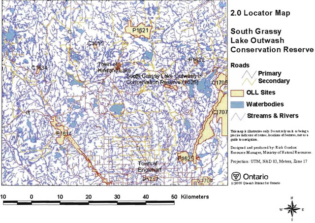
2.0 Locator map
3.0 Description of South Grassy Lake Outwash Conservation Reserve (C1626)
3.1 General setting
The South Grassy Lake Outwash Conservation Reserve is composed of approximately 158 hectares (ha) of conservation reserve and 267 ha of forest reserve for a total area of 425 ha of Crown land and is found within McElroy and Hearst Townships in the District of Timiskaming. The conservation reserve includes the southern edge of Grassy Lake, and sections of the Misema River and Estrangement Creek as its northern and eastern boundaries. The nearest town is Larder Lake a small residential area with churches, a public school, medical facility and a population of approximately 1000. Basic supplies can be purchased along the Highway 66 corridor. The Town of Kirkland Lake with a population of approximately 10,000 is located 18 km west of the conservation reserve. The Town of Kirkland Lake has most commonly found shopping, restaurant, recreation, medical and entertainment facilities.
A number of protected areas are found within 30 km of the site (2.0 Locator Map). These include one recently regulated Provincial Park, three established Provincial Parks with new additions (one addition regulated & one addition in the regulation process) and three recently regulated conservation reserves (2.0 Locator Map): Gem Lake Maple Bedrock Provincial Park (P1632), Larder River Provincial Park and addition (P1625), Esker Lake Provincial Park and addition (P1621), Kap-Kig-lwan Provincial Park and addition (P1614), Maisonville Bernhardt Muskeg Maple Moraine Conservation Reserve (C1615), McGarry Township Forest Conservation Reserve (C1705) and the East Larder River Bedrock Conifer Conservation Reserve (C1707).
The Kirkland Lake District Office is the closest Ministry of Natural Resources Office to the site located along the Highway 66 corridor in the Town of Kirkland Lake. Administration of the site will be coordinated under the direction of the MNR’s Kirkland Lake District, KLK/Claybelt Area Supervisor.
3.2 Cultural values
Little is known about the cultural values of the conservation reserve. The nearby Town of Larder Lake is rich with historical lore, including tales of Natives quarrying for arrowheads 5000 years ago, European fur traders struggling for ownership of trading posts and routes, lumber camps and mills in the early 1900s, and more… The cultural values GIS layer shows a high potential for cultural values along the Misema River Water Corridor along the west and northern boundaries of the site.
3.3 Life science values
To date the life sciences features of the South Grassy Lake Outwash Conservation Reserve have not been well documented. The need for more detailed inventories has been identified and, at the time of writing, a Life Sciences Check Sheet for the site was being prepared.
3.4 Earth science values
To date the earth science features of the South Grassy Lake Outwash Conservation Reserve have not been well documented. The need for more detailed inventories has been identified and, at the time of writing, an Earth Science Check Sheet for the site was being prepared.
4.0 Methodology
The information that was gathered in this recreation inventory represents two different research approaches, as both primary and secondary sources were used throughout the study. Primary research consisted of field visits and a series of discussions with local residence and seasonal visitors, Conservation Officers and District Staff, while the consultation of internal documents and published reports was considered to be secondary research (Table 1). The original intent was to use secondary sources as the background information that would guide subsequent field visits, which meant that secondary research was to be conducted prior to any field visits. However, due to the short duration of the field season, this approach was not always possible and/or feasible. Instead, primary and secondary sources were often utilized concurrently.
Table 1: Summary of information sources
[Table converted to a list for better accessibility]
- Primary research: Two ground visits (June 17 and September 02, 2003) Secondary research: Internal OLL documents/Blob reports
- Primary research: Arial visit (September 22, 2003) Secondary research: FMP, OBM and OLL maps
- Primary research: Contact with district staff Secondary research: DLUG
- Primary research: Contact with local residents Secondary research: Inventory reports
- Primary research: Web site for the Town of Larder Lake Secondary research: Internet research
- Primary research: N/A Secondary research: MNDM Claim maps
The two ground visits were each a day in length and covered ATV, snowmobile and game trails within the site boundaries. During all visits, notes were made, digital photographs were taken of important features, and trails and important features co ordinates were recorded using handheld GPS units. The trails and features were later downloaded and incorporated within GIS produced maps (Appendix A).
The information gathered during the site visits (Appendix D) was then combined with that from the secondary sources to complete the recreational checklist (Appendix B). The checklist was completed in accordance with the Ontario’s Living Legacy Guidelines for Recreational Inventory Reports, version 3. The data was also entered into the Microsoft Access database form provided. All collected data regarding the South Grassy Lake Outwash site was documented and incorporated into GIS maps of the site.
5.0 Recreation features
Recreation features are biophysical or cultural attributes that may be able to support recreational activity. A total of seven features were recorded and ranked according to their recreational value and importance on the Recreational Checklist Form (Appendix B). Features were selected from a list of known recreation features included in the Ontario’s Living Legacy Guidelines for Recreational Inventory Reports. Each feature listed also has a corresponding code, and is classified under a specific category. The following seven sections provide more detail on each of the features and are organized by their rankings, and then listed by feature, feature code and feature category.
5.1 Land mammals, large (W03) - wildlife
Through site visits and observation of vegetation, forest cover, animal tracks and droppings it is fair to say that the expected large game animals moose (A. americanus), and black bear (Ursus americanus) of the region can be found within the conservation reserves boundaries. A young moose was observed along the eastern site boundary during one site visit (cover page). The entire site is also part of a Bear Management Area which suggests the area supports a bear population. The main snowmobile trail running to the east and south of the site has several ATV trails that branch off and lead to hunting stands. GIS layers of the area also confirm moose calving areas within the site boundaries with many harvested areas to the east and south of the site providing moose feed areas.
5.2 Wildlife, general (W00) - wildlife
During ground inventory work evidence of a number of small land mammals was prevalent throughout the site. Observation of vegetation, forest cover, animal tracks and droppings suggest the following small animals reside within the conservation reserve: marten (M. martes), fox (V. fulvus), fisher (Mustela canadensis), beaver (Castor canadensis), mink (Putorius lutreola), otter (L. canadensis), muskrat (Fiber zibethicus) and weasel (Mustela), red squirrel (Tamiasciurus hudsonicus), rabbits & hares (L. americanus), woodcock (Philohela minor), grouse (Bonasa umbellus) and others.
5.3 Mixed coniferous/deciduous (E05) - Vegetation features
Much of the site can be described as young spruce mixed wood forest on moderately broken bedrock located over 90% of the conservation reserve area. Several locations within the site contain swamplands with black spruce mixed forest. The majority of the forest reserve associated with the site is old growth forest at 80+ years that contains Poplar mixed, black spruce mixed and white spruce mixed forests.
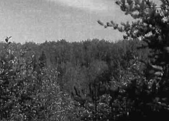
Mixed deciduous/conifer forest east of Estrangement Creek. Site C1626
Ground Inventory
September 02, 2003
Photo by Rick Gordon
5.4 Lake, mid size (41-200 ha), (M03) - Waterbodies
Grassy Lake although not found within the conservation reserve does make up the northern boundary of the site. Grassy lake is accessible by a private road from Hwy 66 and is known to be a fishing destination for locals. There was limited information to be obtained regarding this lake however, the following applies; the lake is a cool water shallow lake that contains Northern Pike and probably other sport fish. The lake is utilized during hunting seasons for waterfowl and moose hunting. There has not been any recent stocking events and may not have been stocked in the past. The only road access to the lake runs through private property and the property owner allows access to the lake for fishing and hunting for a price. The property owner also promotes the fall hunt and receives an allocation of hunting tags from OMBAAC (Ontario Moose and Bear Allocation Advisory Committee) as a tourist outfitter shareholder. The dominant types of vegetation in and around the lake are; sedge (Carex spp.), leatherleaf (Chamaedaphne calytulate), larch (Larix laricina), willow (Salix app.), cattail (Typha spp.) blue-joint (Calamagrostis sp.) and tag elder (Alnus sp.), hard stem bulrush (Scirpus actus), burreed (Spargsnium fluctuans), coontail (Ceratophyllum demersum), bladderwort (Uitricularia spp.), pondweeds (Pontomageton spp.) and yellow water lily (Nuphar sp.).
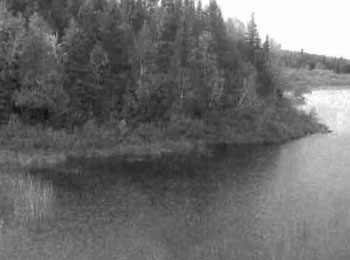
South shore of Grassy lake, northern boundary of the South Grassy Lake Outwash Conservation Reserve. Site C1626 Aerial Photo
Flown September 22, 2003
Photo by Jennifer Telford
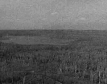
Picture of Grassy lake looking southeast, shows marshlands surrounding Grassy lake and mixed conifer/deciduous forest to the south. Site C1626 Aerial Photo
Flown September 22, 2003
Photo by Jennifer Telford
5.5 Developed snow trails (T02) - Trails or routes
A main snowmobile trail running north from the Town of Englehart and connecting to the Town of Larder Lake, makes up a part of the south western conservation reserves boundary and runs through the center of the forest reserve. The mid part of this trail is not accessible by ATV in the summer months as it travels through deep bog and across several unnamed water bodies.
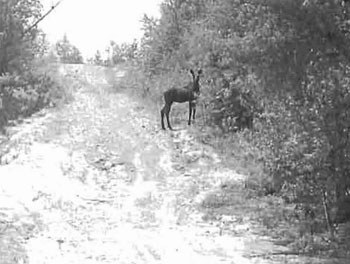
Young moose along eastern border of forest reserve on main snowmobile trail connecting the Town’s of Larder Lake and Englehart. Site C1626
Ground Inventory
June 17, 2003
Photo by Rick Gordon
5.6 Existing trail (T08) - Trails or routes
There are a number of ATV trails (Appendix A) that branch off of the Main snowmobile trail that runs through the forest reserve in the north and along the southern edge of the conservation reserve to the south. The ATV trails access remote area’s to conduct hunting activities. Several hunting stands and camps were witnessed along these trails. Parts of these ATV trails were former Forest access roads for timber harvesting. A forest harvest road from Highway 624 provides access to the southern edge of the conservation reserve. This forest access road is utilized by recreation enthusiasts, ATV'ers, hunters, cottage owners to the south of the site and provides access to the Misema river system for canoeists.
5.7 Junction of rivers and streams (001) - Hydrological features
The Ontario Recreational Canoeing Association has identified the waterbodies associated along the borders of South Grassy Lake Outwash Conservation Reserve as part of their clienteles existing canoeing destinations. This canoe trail travels along the Misema River through Grassy Lake and on to the Misema River system again. We have no recorded data that details the number of canoeing enthusiast that may use this river system. During the two ground visits and the aria! reconnaissance no canoeists where sighted on the river system.
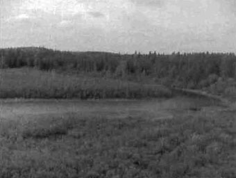
Misema River system south of Grassy Lake makes up a part of the Conservation Reserves Western border. Site C1626 Aerial Photo
Flown September 22, 2003
Photo by Jennifer Telford
6.0 Recreational activities
The recreation activities are closely related to the recreation features, although there is not necessarily a direct correlation, as one feature may have the potential to support a wide variety of recreational activities. During the recreational inventory, eight activities were recorded and ranked on the Recreation Inventory Checklist (Appendix B). Activities were selected from a list of known recreational activities included in the Ontario’s Living Legacy Guidelines for Recreation Resource Inventory, Version 3. Each activity listed also has a corresponding code, and is classified under a specific category. Existing activities were differentiated from potential activities by using a capital letter in their activity code. The following eight sections provide more details on each of the features and are organized by their rankings, and listed by activity, activity code and activity category.
6.1 Hunting, general (H00) - Hunting and trapping
The number of hunting stands and camps located throughout the site and in the surrounding area would suggest that the conservation reserve is part of a traditionally used hunting area. Moose feeding and calving areas within the site and surrounding area support the existence of a healthy moose population for the sport of hunting. The surrounding mixed forest area with evidence of berries and vegetation as well as bear sign and scat, suggest good habitat for black bear. A hunting guiding outpost located just outside the conservation reserve promotes the fall hunt and receives an allocation of hunting tags from OMBAAC (Ontario Moose and Bear Allocation Advisory Committee) as a tourist outfitter shareholder. Other game animals hunted within or near the site are rabbit and hare, grouse, waterfowl and possibly deer. Hunters were observed within the site during the aerial recreation inventory.
Fall hunt camp located to the south of the conservation reserve along connecting ATV trails that provide access for hunters. Site C1626
Ground Inventory June 17, 2003
Photo by Rick Gordon
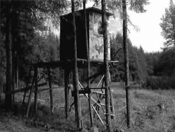
Picture of hunting stand accessed by ATV trails located on the west side of Estrangement Creek. Site 1626
Ground Inventory June 17, 2003
Photo by Rick Gordon
6.2 Trapping (H06) - Hunting and trapping
One established and active traplines (Appendix C) overlaps the South Grassy Lake Outwash Conservation Reserve, while two other traplines impact parts of the forest reserve. No trapper’s cabins are located near or within the reserve. Many small mammal tracks and droppings were observed during site visits as well as beaver houses observed within the lake, river system and wetland areas.
6.3 Berry picking (G02) - Gathering/collecting
Much of the area along Highway 66 between Kirkland Lake and the Ontario-Quebec border contains excellent blueberry habitat with sandy areas and many cutovers. There are several excellent berry picking areas in and around the conservation reserve. Although our site visits were not during the prime berry picking season and no berry pickers were observed within the site, it is quite likely the area was used for the activity.
6.4 Fishing, general (F00) - Fishing
Recorded data concerning the nature of fishing opportunities within Grassy Lake and Misema waterway is limited to non-existent. We do know that fisherpersons pay for the privilege of accessing the lake for fishing during the summer months. Our local area biologist supplied the following information regarding Grassy Lake, the lake is a cool water, shallow lake that contains Northern Pike and probably other sport fish, ice fishing likely occurs.
6.5 Snowmobiling (010) - Snow sports
The existence of a mainline snowmobile trail through the forest reserve and as part of the southern boundary suggests heavy snowmobile traffic on the trail. The possibility of further snowmobile use off of the existing trail is slim as there is heavy forest on either side of the trail and no recreational opportunities. Grassy Lake would see some snowmobile use for ice fishing opportunists. The existence of an active trap area may also support some off trail snowmobile use.
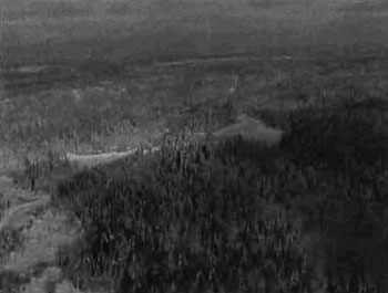
Main snowmobile trail between Englehart and Larder that makes up a portion of the southern edge of the conservation reserve and runs through the middle of the forest reserve. Picture shows the snowmobile trail running south to north across two unnamed waterbodies. C1626 Aerial Photo
Flown December 01, 2000
Picture by E. Coulson
6.6 ATV (T01) - Travelling
We found ATV activity and trails in the north eastern forest reserve and again to the west of the site through pure jack pine plantations, but no direct ATV use within the site other than along the south eastern part of the snowmobile trail. There were extensive ATV trails to the south of the site with hunting stands and hunt camps located along side of the trails. The existence of further ATV trails within the site is possible as parts of the snowmobile trail were flooded due to beaver activity making further exploration impossible, at the time. Much of the area surrounding the Highway 66 corridor supports ATV use with many trails in existence. This is due to the pine forests and sandy conditions that make ATV trail building and maintenance an easy project. Parts of the ATV trails and Snowmobile trails were recorded during ground inventory work using handheld GPS technology and were incorporated within the conservation reserve map (Appendix A).
6.7 Canoeing (802) - Water sports
We know from the Ontario Recreational Canoeists Association (ORCA) letter and our GIS (Appendix A) information that the Misema River system of which Grassy lake is a part, is utilized by canoeing enthusiasts as an established canoe route. The Misema and Grassy Lake waterbodies are quite picturesque, calm and well suited to canoe travell. During the brief field and aerial observations no canoeists were observed in these water systems, although several prospective lunch areas were.
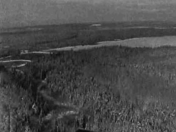
Winter picture of northeastern corner of the conservation reserve where grassy lake flows into the Misema River and the Estrangement Creek tributary. C1626 Aerial Photo
Flown December 01, 2000
Picture by E. Coulson
6.8 Nature activities, general, (N00) - Nature activities
The South Grassy Lake Outwash Conservation Reserve would be suitable for most nature activities such as; drawing, painting, wildlife identification, nature study, photography, relaxation, solitude, general viewing etc.
7.0 Recreation factors
The recreational factors provide a context for the information collected during the recreational inventory, as they are meant to provide some insight on how the site will contribute to outdoor recreation at the regional level.
7.1 Feature significance:
Feature significance for the conservation reserve, which is the composite measure of feature scarcity and uniqueness, activity attraction capability, scenic attractiveness, and geographic significance, was rated as low to moderate. This designation resulted from the fact that no factors had a rating above moderate with most falling within the low range. In the future with more forest harvesting in the area and with the forest protection provided by the conservation reserve designation this site may become more attractive to local and tourist activity.
An evaluation of the recreation features determined that none of the features could be considered scarce. We here in Northern Ontario are blessed with an abundance of great fishing lakes, scenic forest settings, bogs and marshes for waterfowl migration and feeding, large game hunting areas, lakes rivers and streams and although there is ORCA interest in canoeing the water system there are many similar canoeing routes and opportunities.
Again, with the abundance of all the above mentioned resources and activities and features there was not one feature that dramatically stands out within the boundaries of this conservation reserve.
The similarity between the site and the rest of the region also influenced the scenic attractiveness and geographic significance ratings, as these were also ranked as low.
Although the site exhibits habitat and recreational hunting diversity, it is unlikely it will see many more visitors than any other Crown land and protected areas located within the region. The area will likely continue to be utilized by hunters and local recreation seekers looking for relatively solitary recreational experiences (i.e. canoeists and general nature observers).
The South Grassy Lake Outwash Conservation Reserve’s activity attraction capability is seen as moderate. The conservation reserve’s size when compared to population density of the surrounding area suggests normal use during the hunting seasons. The hunter interest and numbers coupled with the Ontario Recreational Canoe Associations interest bumped the activity attraction rating from low to moderate.
7.2 Feature sensitivity to recreation use:
No features were found to be sensitive to recreational use in the South Grassy Lake Outwash Conservation Reserve. With hunting and trapping pressure seen as being at normal levels, recreational use would have little effect upon the wildlife. The forest systems are healthy and won't suffer from current uses or additional recreational activity. Grassy lake is not part of the conservation reserve and will only draw minimal numbers of recreational users. The snowmobile and ATV trails are established would not be dramatically effected by additional use. The rivers and streams are not seen as drawing many users as they do not supply large amounts of Sport fish or cottaging and recreational use features.
7.3 Feature sensitivity to resource development:
The feature sensitivity to resource development near the South Grassy Lake Outwash Conservation Reserve was ranked as moderate and would have the biggest effect on the rivers, streams and waterbodies. Upstream pollution from any source that would put debris, silt or chemicals into the water system, would have the greatest effect upon the scenic nature and fisheries associated with these water systems.
7.4 Cultural/historic and archeological features:
To date no cultural, historic or archeological features have been discovered within the South Grassy Lake Outwash Conservation Reserve boundaries. Areas of high cultural, historic or archeological significance are identified within our mapping layers (Appendix C) and show the Misema and Grassy Lake waterbody systems as potential for high cultural historic or archeological significance. This cultural and archeological potential could be attributed to early settlers, trappers and aboriginal peoples past activities along the waterways.
8.0 Recommendations
Upon completion of this first phase of the recreational inventory, a series of recommendations were made. The recommendations, which were grouped into several broad categories, are as follows.
8.1 Additional research
- Field visits should be made during the winter months to confirm and document other activities, such as snowmobiling and ice fishing.
- Determination of existence of further access trails leading into the site for recreational ATV and hunting purposes.
- Studies to determine fish types and quantities within Grassy Lake and Misema waterbodies could be undertaken, and if feasible, fish stocking of the lake or fish habitat enhancements conducted. The study may also look at the possibility of recreational sensitivity to this feature.
- Some effort could be made to monitor hunting numbers and hunting pressures for this site.
8.2 Future management
- Future enhancement to the fisheries of the waterbodies next to the conservation reserve may make the site more attractive to recreational use (i.e. camping and fishing).
- Care should be taken to ensure that all District staff is given access to the information contained within this report and that NRVIS layers are periodically updated to reflect any new information.
References
Gordon, R. 2003. South Grassy Lake Outwash Recreation Inventory Checklist Recreation Inventory Access Database.
Mulrooney D. 2001, Ontario’s Living Legacy Guidelines for Recreation Resource Assessment Version 3 - May 2002, Prepared for Ontario Parks, Planning and Research Section, 30 pages.
Ontario Ministry of Natural Resources, South Grassy Lake Outwash Conservation Reserve (1626) Factsheet, September, 2000.
Ontario Ministry of Natural Resources, 1999. Ontario’s Living Legacy - Land Use Strategy, July, 1999.
Ontario Ministry of Natural Resources, Kirkland Lake District, Land Use Guidelines, 1983.
Kendra Couling & F.J. (Rik) Kristjansson, 2003. Life and Earth Science information during South Grassy Lake Outwash Conservation Reserve (1626) Aerial Flight September 22, 2003.
Larry Ferguson, 2003, Ministry of Natural Resources, Biologist for KL/Claybelt Area team, Kirkland Lake District.
Ministry of Northern Development and Mines, Claimaps Website, 2003. Web Site, 2004, Canadian canoe routes website
Recreation inventory checklist
- Name: South Grassy Lake Outwash
- Map name: Larder Lake
- NTS Number: 32D/SW
- UTM reference: 589853E, 532626N
- OBM Number: 580053200
- Latitude: 48° 4′ 59.89″
- Longitude: 79° 47′36.63″
- Area (ha): 268
- Ownership: Crown
- MNR region: Northeast
- MNR district: Kirkland Lake
- Park zone: Northeast
- Count: Timiskaming
- Township: McElroy, Hearst
Recreation features
- W03 - Land mammals, large
- W00 - Wildlife, general
- E05 - Coniferous/deciduous
- M03 - Lake mid-size (41-200 ha)
- T02 - Developed snow trails
- T08 - Existing trail
- D01 - Junction of rivers/streams
Recreation activities
- H00 - Hunting, general
- H06 - Trapping
- G02 - Berry picking
- F00 - Fishing, general
- D10 - Snowmobiling
- T01 - ATV
- 802 - Canoeing
- N00 - Nature activities, general
| Recreation | Features | Rating: Very high, high, moderate, low, N/A |
|---|---|---|
| Most scarce feature | N/A | N/A |
| Feature scarcity | N/A | N/A |
| Most unique feature | N/A | N/A |
| Activity attraction capability | N/A | Moderate |
| Scenic attractiveness | N/A | Low |
| Geographic significance | N/A | Low |
| Feature significance | N/A | Low |
| Most sensitive feature to recreation | N/A | N/A |
| Feature sensitivity to recreation use: | N/A | Low |
| Most sensitive feature to resource | 7 | N/A |
| Feature sensitivity to resource development | N/A | Moderate |
| Cultural/historic and archaelogical features | N/A | C |
Comments
The South Grassy Lake Outwash Conservation Reserve is situated approximately 18 km southeast of the Town of Kirkland lake and 4 km southwest of the Town of Larder Lake. It is within the Townships of McElroy and Hearst and occupies an area of approximately 156 hectares of conservation reserve and 112 ha of forest reserve.
Date compiled
September 22, 2003
Compiler
Rick Gordon
Source: Recreation Resource Inventory standards and Procedures draft report, Government of British Columbia, Ministry of Forests Range, Recreation and Forests Practices Branch, March 1995.
Ontario Ministry of Natural Resources, Ontario Parks
300 Water Street. Peterborough, Ontario K9J BN1
South Grassy Lake Outwash trails and values
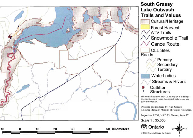
Enlarge South Grassy Lake Outwash trails and values map
Wildlife areas in and around the conservation reserve
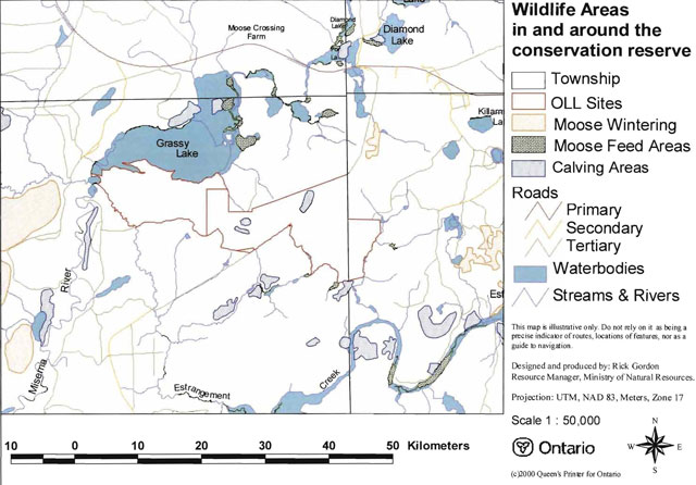
Enlarge wildlife areas in and around the conservation reserve map
Wildlife management area’s overlaying the conservation reserve
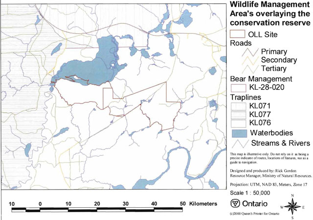
Enlarge wildlife management area’s overlaying the conservation reserve map
South Grassy Lake Outwash Conservation Reserve - C1626 fact sheet
June 08, 2003
Background
On July 16, 1999, the Ontario Government released the Ontario’s Living Legacy Land Use Strategy to guide the planning and management of Crown lands in central and parts of northern Ontario. A major part of the Ontario’s Living Legacy Land Use Strategy was a government intent to establish 378 new protected areas. This commitment marks the biggest expansion of provincial parks and conservation reserves in Ontario’s history.
The South Grassy Lake Outwash Conservation Reserve is part of the significant expansion of Ontario’s protected areas system. Following public and aboriginal consultation in the year 2000 on refining the boundary of this protected area, Ontario Regulation 805/94 of the Public Lands Act was amended on April 4, 2001, by Ontario Regulation 86/01, to formally establish this conservation reserve.
Size and location
The South Grassy Lake Outwash Conservation Reserve, consists of 156 hectares of land residing in McElroy Township, in the District of Timiskaming.
Area highlights
Young spruce on moderately broken bedrock are the primary representative features of this site.
Land use intent
Conservation reserves are areas of Crown land set aside by regulation under the Public Lands Act.
Conservation reserves complement provincial parks in protecting representative natural areas and special landscapes. Most recreational; (e.g. hiking, skiing, tourism related uses, nature appreciation) and non-industrial (e.g. fur harvesting, commercial fishing and bait fishing) activities that have traditionally been enjoyed in the area will continue, provided that these uses do not impact on the natural features needing protection. Hunting and fishing are permitted within all new conservation reserves proposed through Ontario’s Living Legacy.
Commercial timber harvesting, mining, aggregate extraction and commercial hydroelectric development are prohibited in conservation reserves. Careful mining exploration may occur in specific conservation reserves proposed through Ontario’s Living Legacy, in areas that have provincially significant mineral potential. If a portion of a new conservation reserve is to be developed for a mine, it would be removed from the reserve, and appropriate replacement lands would be placed in regulation.
Next steps
In the future, the Ministry of Natural Resources will prepare a long-term management plan for this area. Depending upon the complexity of the issues within this conservation reserve, management planning may initially take the form of a simple Statement of Conservation Interest or a more detailed Resource Management Plan.
Planning, management and the uses permitted within the conservation reserve will be consistent with the commitments of the Ontario’s Living Legacy Land Use Strategy.
For more information
For further information on the proposed South Grassy Lake Outwash Conservation Reserve, please contact:
Shaun Walker, District Planner
Ministry of Natural Resources
Kirkland Lake District
Email: shaun.walker@mnr.gov.on.ca [inactive]
You may also visit the Ministry’s Internet website at Ontario’s Living Legacy for information on Ontario’s Living Legacy.
Appendix 4: Procedural Guideline 8 - Land Uses - Test of Compatibility (PL Procedure 3.03.05)
- The Conservation Reserve policy provides broad direction with regard to the permitted uses. The policy provides only an indication of the variety of uses that will be considered acceptable in Conservation Reserves. The only caution is that “any new uses, and commercial activities associated with them, will be considered on a case by case basis and, they must pass a test of compatibility to be acceptable.”
What does a “test of compatibility” mean? An examination of this must start from the premise of why an area is set aside- specifically, its representative natural heritage values. Criteria are then identified to guide compatibility considerations. These criteria apply to the long-term acceptability of both existing uses and new uses.
- Conformity to SCI/RMP: SCI describes values for which an area has been set aside and the range of appropriate uses that will be permitted in the area. SCI may also speak to the acceptability of other ‘new’ uses currently not occurring in the area.
- The first ‘test’ is: “do proposed new land uses and/or commercial activities conform to the direction of the SCI/RMP for the Conservation Reserve? Would the new use(s) depart from the spirit of appropriate indicator land uses in the SCI/RMP?”
- Impact assessment: If the proposed use(s) pass test 1 it is important to determine their impact on the area before they are approved. This should include the following:
- Impact on natural heritage values: “will the new use(s) impact any natural values in the area? If so, how and to what degree? Is it tolerable?”
- Impact on cultural values: “will the new use(s) impact any historical or archaeological values in the area?”
- Impact on research activities: “will the new use(s) affect research activities in the area?”
- Impact on current uses: “will the new use(s) have any negative impact on the array of current uses?”
- Impact on area administration: “will the new use(s) increase administrative cost and/or complexity?” (For example, the cost of area monitoring, security or enforcement).
- Impact on accommodating the use outside the Conservation Reserve: “Could the use(s) be accommodated as well or better outside the Conservation Reserve?”
- Impact on socio-economics of the area: “will the new use(s) affect the community (ies) surrounding the area in a positive or negative way?” (For example, will the new use make an area less remote thereby affecting a local tourism industry that is dependent on the area’s remoteness for its appeal?).
- Impact on area accessibility: “does the new use(s) give someone exclusive rights to the area or a portion of the area to the exclusion of other existing uses?”
Appendix 5: Procedural Guideline C - research activities in conservation reserves
Purpose
To encourage contributions to the goal of conservation reserves by:
- Providing direction for research activities associated with conservation reserves: and
- Establishing a process for the review and approval of proposals by researchers, which could have an impact on the values protected by the conservation reserve.
Definition
Research means any investigation or study of the natural, cultural, social, economic, management or other features of characteristics of conservation reserves.
Guidelines
Research will be encouraged to provide a better understanding of the natural values protected by a conservation reserve and to advance their protection, planning and management. The Statement of Conservation Interest will define, for each conservation reserve, the key research issues, set out the parameters within which research may occur and identify research needs.
Applications and approvals
Researchers must apply in writing to the Area Supervisor for permission to conduct research. The request letter must contain a statement explaining why the proposed research should be undertaken in the particular conservation reserve in preference to another location.
Proposals will be reviewed and approved by the Area Supervisor, guided by the Statement of Conservation Interest prepared for each reserve (See Guideline A Resource Management Planning) and using Guideline 8 - Land Uses - Test of Compatibility. Permission must be granted in writing, including any conditions to be met in conducting the research, prior to the undertaking of any research project.
Terms and conditions
Permission to conduct research under this policy will be valid for a period of 12 consecutive months from date of issue. Permission to continue a research project for additional periods of 12 months or less may be granted upon submission of a written request and progress report. The Ministry may require the posting of collateral to assure that the terms and conditions of granting permission are to be met.
The Area Supervisor may suspend or revoke permission at any time for failure on the part of the researcher to meet:
- The intent or conditions of this policy.
- The requirements under the Public Lands Act, including all amendments, where applicable.
- The requirements under any other Act or Regulations or Ontario or Canada, including those governing the taking, handling, storing, confining, trapping, excavating and marketing any specimen, artifact, information or action (for example, scientific collector’s permit).
- The conditions and agreements specified in granting permission.
Final report
The researcher will submit copies of reports, publications and theses following from the results of the project to the Area Supervisor.
Appendix 6: Crown Land Use Atlas - Policy report
South Grassy Lake Outwash C1626
Updated: February 16, 2005
Crown Land Use Policy Atlas website
Identification:
ID: C1626
Area name: South Grassy Lake Outwash
Area (ha): 156
Designation: Conservation Reserve (Ontario’s Living Legacy)
MNR District(s): Kirkland Lake
Description:
Young spruce on moderately broken outwash deposits and moderately broken bedrock are the primary representative features of this site.
South Grassy Lake Outwash was regulated as a conservation reserve on April 6, 2001.
Land use intent:
Management of this area is also governed by the general policies contained in the Land Use Strategy (1999).
Management direction:
Those uses and management activities not listed in the following table are governed by existing conservation reserve policy. Over time the management direction will be elaborated in a Statement of Conservation Interest or Resource Management Plan. Any new uses, and commercial activities associated with conservation reserves, will be considered on a case by case basis, and they must pass a test of compatibility to be acceptable. Compatibility is normally determined through a planning process.
Commercial activities
| Activity | Permitted | Guidelines |
|---|---|---|
| Aggregate extraction | No | N/A |
| Bait fishing - existing | Yes | Existing use permitted to continue, unless there are significant demonstrated conflicts. |
| Bait fishing - new | Maybe | New operations can be considered, subject to the “test of compatibility”. |
| Commercial fishing - existing: | Yes | Existing use permitted to continue, unless there are significant demonstrated conflicts. |
| Commercial fishing - new: | Maybe | New operations can be considered, subject to the “test of compatibility”. |
| Commercial fur harvesting - existing | Yes | Existing use permitted to continue, unless there are significant demonstrated conflicts. Existing trap cabins can continue; new cabins are not permitted. |
| Commercial fur harvesting - new | Maybe | New operations can be considered, subject to the “test of compatibility”. |
| Commercial hydro development | No | N/A |
| Commercial timber harvest | No | N/A |
| Commercial tourism - existing | Yes | Existing authorized facilities can continue, unless there are significant demonstrated conflicts. |
| Commercial tourism - new | Maybe | New tourism facilities can be considered during the planning for an individual reserve. |
| Bear hunting by non-residents (guided) - existing | Yes | Existing authorized operations permitted to continue. |
| Bear hunting by non-residents (guided) - new | No | New operations not permitted. |
| Outfitting services - existing | Yes | Existing authorized operations permitted to continue. |
| Outfitting services - new | Maybe | New operations can be considered during the planning for an individual reserve. |
| Outpost camps - existing | Yes | Existing authorized operations permitted to continue. |
| Outpost camps - new | Maybe | New operations can be considered during the planning for an individual reserve. |
| Resorts/lodges - existing | Yes | Existing authorized facilities permitted to continue. |
| Resorts/lodges - new | Maybe | New facilities can be considered during the planning for an individual reserve. |
| Energy transmission and communications corridors - existing | Yes | These facilities should avoid conservation reserve lands wherever possible. |
| Energy transmission and communications corridors - new | No | These facilities should avoid conservation reserve lands wherever possible. |
| Food harvesting (commercial) - existing | Maybe | N/A |
| Food harvesting (commercial) - new | Maybe | N/A |
| Mineral exploration and development | No | N/A |
| Peat extraction | No | N/A |
| Wild rice harvesting - existing | Yes | N/A |
| Wild rice harvesting - new | Maybe | N/A |
Land and resource management activities
| Activity | Permitted | Guidelines |
|---|---|---|
| Crown land disposition - private use | Maybe | Sale of lands is not permitted, except for minor dispositions in support of existing uses (e.g. reconstruction of a septic system). Renewals of existing leases and land use permits are permitted. Requests for transfer of tenure will be considered in the context of the Statement of Conservation Interest or Resource Management Plan. New leases or land use permits permitted for approved activities. Tourism facilities can apply to upgrade tenure from LUP to lease. |
| Crown land disposition - commercial use | Maybe | Sale of lands is not permitted, except for minor dispositions in support of existing uses (e.g. reconstruction of a septic system). Renewals of existing leases and land use permits are permitted. Requests for transfer of tenure will be considered in the context of the Statement of Conservation Interest or Resource Management Plan. New leases or land use permits permitted for approved activities. Tourism facilities can apply to upgrade tenure from LUP to lease. |
| Fire suppression | Yes | Fire suppression policies are similar to adjacent Crown lands, unless alternative fire policies have been developed through a planning process. |
| Fish habitat management | Maybe | N/A |
| Fish stocking | Maybe | Conservation Reserves policy indicates that “featured species management” may be permitted. |
| Insect/disease suppression | Maybe | N/A |
| Inventory/monitoring | Yes | N/A |
| Prescribed burning | Maybe | N/A |
| Roads (resource access) - existing | Yes | Existing roads can continue to be used. Continued use will include maintenance and may include future upgrading. |
| Roads (resource access) - new | Maybe | New roads for resource extraction will not be permitted, with the exception of necessary access to existing forest reserves for mineral exploration and development. |
| Vegetation management | Maybe | Conservation Reserves policy indicates that Featured Species Management and Natural Systems Management may be permitted. Vegetation management can be considered in a planning process. |
| Wildlife population management | Maybe | N/A |
Science, education and heritage appreciation
| Activity | Permitted | Guidelines |
|---|---|---|
| Collecting | No | N/A |
| Historical appreciation | Yes | N/A |
| Nature appreciation | Yes | N/A |
| Photography and painting | Yes | N/A |
| Research | Yes | N/A |
| Wildlife viewing | Yes | N/A |
Recreation activities and facilities
| Activity | Permitted | Guidelines |
|---|---|---|
| All terrain vehicle use - on trails | Yes | Existing use permitted to continue where it does not adversely affect the values being protected. |
| All terrain vehicle use - off trails | No | ATV use off trails is not permitted, except for direct retrieval of game. |
| Campgrounds | Maybe | N/A |
| Food gathering | Yes | N/A |
| Horseback riding (trail) | Yes | Existing use on trails permitted. |
| Hunting | Yes | N/A |
| Mountain bike use | Yes | Existing use on trails permitted. |
| Motor boat use - commercial | Yes | N/A |
| Motor boat use - new | Yes | N/A |
| Non-motorized recreation travel | Yes | N/A |
| Private recreation camps (hunt camps) - existing | Yes | Existing camps permitted to continue, and may be eligible for enhanced tenure, but not purchase of land. |
| Private recreation camps (hunt camps) - new | No | Existing camps permitted to continue, and may be eligible for enhanced tenure, but not purchase of land. |
| Rock Climbing | Maybe | N/A |
| Snowmobiling - on trails | Yes | Except for the direct retrieval of game. |
| Snowmobiling - off trails | No | N/A |
| Sport fishing | Yes | N/A |
| Trail development - existing | Yes | Development of trails for a variety of activities (e.g., hiking, cross-country skiing, cycling, horseback riding, snowmobiling) can be considered as part of planning for an individual reserve. |
| Trail development - new | Maybe | Development of trails for a variety of activities (e.g., hiking, cross-country skiing, cycling, horseback riding, snowmobiling) can be considered as part of planning for an individual reserve. |
Note: The policies outlined in this table do not supersede any Aboriginal or treaty rights that may exist, or other legal obligations.
Management of this conservation reserve is carried out within the context of Conservation Reserve policy as amended by the policies for new conservation reserves outlined in the Ontario’s Living Legacy Land Use Strategy.
Source of direction:
Ontario’s Living Legacy Land Use Strategy (1999)
Conservation Reserves Policy (1997)
Appendix 7: Locator map
Enlarge Figure 1.0 South Grassy Lake Outwash Conservation Reserve
Recreation inventory checklist
- Name - South Grassy Lake Outwash
- Map name - Larder Lake
- NTS Number - 32D/SW
- UTM reference - 589853E, 532626N
- OBM Number - 580053200
- Latitude - 48° 4′ 59.89″
- Longitude - 79° 47′ 36.63″
- Area (ha) - 268
- Ownership - Crown
- MNR region - Northeast
- MNR district - Kirkland Lake
- Park zone - Northeast
- Count - Timiskaming
- Township - McElroy, Hearst
Recreation features
- W03 - Land mammals, large
- W00 - Wildlife, general
- E05 - Coniferous/deciduous
- M03 - Lake mid-size (41-200 ha)
- T02 - Developed snow trails
- T08 - Existing trail
- D01 - Junction of rivers/streams
Recreation activities
- H00 - Hunting, general
- H06 - Trapping
- G02 - Berry picking
- F00 - Fishing, general
- D10 - Snowmobiling
- T01 - ATV
- 802 - Canoeing
- N00 - Nature activities, general
| Recreation | Features | Rating: Very high, high, moderate, low, N/A |
|---|---|---|
| Most scarce feature | N/A | N/A |
| Feature scarcity | N/A | N/A |
| Most unique feature | N/A | N/A |
| Activity attraction capability | N/A | Moderate |
| Scenic attractiveness | N/A | Low |
| Geographic significance | N/A | Low |
| Feature significance | N/A | Low |
| Most sensitive feature to recreation | N/A | N/A |
| Feature sensitivity to recreation use: | N/A | Low |
| Most sensitive feature to resource | 7 | N/A |
| Feature sensitivity to resource development | N/A | Moderate |
| Cultural/historic and archaelogical features | N/A | C |
Comments
The South Grassy Lake Outwash Conservation Reserve is situated approximately 18 km southeast of the Town of Kirkland lake and 4 km southwest of the Town of Larder Lake. It is within the Townships of McElroy and Hearst and occupies an area of approximately 156 hectares of conservation reserve and 112 ha of forest reserve.
Date compiled
September 22, 2003
Compiler
Rick Gordon
Source: Recreation Resource Inventory standards and Procedures draft report, Gov. of British Columbia, Ministry of Forests Range, Recreation and Forests Practices Branch, March 1995.
Ontario Ministry of Natural Resources, Ontario Parks
300 Water Street. Peterborough, Ontario K9J BN1
Appendix 8: Natural Heritage - Life science checksheet
- Name: C1626 - South Grassy Lake Outwash Conservation Reserve
- Map name: Larder Lake
- Map number: 32D/4
- UTM Ref.: 590533
- Locality: Timiskaming
- Latitude: 48°04′58″N
- Longitude: 79°47′15″W
- NAD: 83 CNT
- Min. Alt.: 270 m
- Max. Alt.: 310 m
- Township: McElroy, Hearst
- Area: 25 ha (267 ha is forest reserve)
- Ownership: Crown
- MNR Region: Northeast
- MNR District: Kirkland Lake
- Ecoregion and Ecodistrict: 3E-6 (Hills 1959; Crins & Uhlig 2000)
Landform Unit(s) Conservation Reserve Only
- 9: Organic deposits
- 8: Alluvial deposits
- 6b: Glaciolacustrine deposits - silt and clay
- 6ad: Glaciolacustrine deposits - silty, fine sand and glaciolacustrine plain glaciolacustrine sediment
- 2df,6b: Bedrock-drift complex - drift cover is thin, but relatively continuous, predominantly glaciolacustrine sediment and subordinate landform glaciolacustrine deposits - silt and clay
- 2cf: Bedrock-drift complex - drift cover is discontinuous and predominantly
Aerial photographs
- Year: 1986
- Flight line: 4803
- Roll - Numbers: 04 - 120
C1626 South Grassy Lake Outwash Conservation Reserve
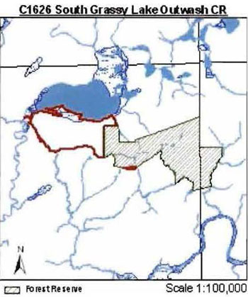
Physical and biological features
Representation
The South Grassy Lake Outwash Conservation Reserve (CR) is located 17 km east of the town of Kirkland Lake, in the Kirkland Lake OMNR District. The west section of the site is directly south of Grassy Lake. Access to the CR is limited to two tertiary roads located in the southwest and northeast, a snowmobile/ATV trail bisecting the site and likely boat access from Grassy Lake. Boundaries of the CR are a combination of biological, cultural and vectored. According to the OLL Land Use Strategy (OMNR 1999) young spruce on moderately broken outwash deposits and moderately broken bedrock are the primary representative features of the site.
The South Grassy Lake Outwash CR is found within the Kirkland Lake ecodistrict 3E-6 (Hills 1959; Grins & Uhlig 2000) of the Lake Abitibi ecoregion 3E. The Kirkland Lake ecodistrict is characterized by moderately broken plains of granitic and low-base bedrock generally thinly covered with granitic and low-base sand and silty sand. Several trains of glaciofluvial sand and gravel occur (Hills 1959 and Poser 1992). The ecoregion landform is characterized by flat to gently rolling, glacial clay and sandplain with local extensive peatlands and wetlands, broken throughout by glacial features such as moraines, eskers and kame/kettle complexes with Canadian Shield exposures. Regional vegetation includes stands of spruce, poplar, and birch on fresh sites on moderately sloping terrain. White pine and red pine occur on sand ridges. American elm and white cedar are found only in protected areas. The forest climate type is mid humid, mid-boreal (Hills 1959).
Bedrock is the dominant landform in the CR according to the Quaternary geology of Ontario coverage (Map 1b). Glaciolacustrine deposits are also present in the site in the central area, far east and in slivers near the northwest corner, along the Grassy Lake shoreline. According to Rik Kristjansson, OLL Geologist, (2004) during the aerial reconnaissance survey and from aerial photo interpretation six surficial geology landforms on the site were determined (Map 1a). Keep in mind when Kristjansson did the surficial geology interpretations only in the west side (excluding forest reserve). The dominant landform was bedrock-drift complex with a thin and relatively continuous drift cover (predominantly glaciolacustrine sediment) and subordinate landform glaciolacustrine deposits of silt and clay (Unit 2df,6b) which is mainly in the east, northeast and central areas. Also, a small section in the northwest and in the northeast has a bedrock-drift complex with a discontinuous drift cover and predominantly glaciolacustrine sediment (Unit 2cf). Glaciolacustrine deposits with silty, fine sand and glaciolacustrine plain dominates the western area (Unit 6ad). It is very interesting because it has been reworked by wind and as a result dunes have formed on the site (Kristjansson 2004). Glaciolacustrine deposits with silt and clay (Unit 6b) are located in the areas immediately east and west of Unit 2df, 6b and it forms a linear area up the center of the CR. Alluvial plain (Unit 8) runs on either side of the river that runs north to Grassy Lake, in the northwest corner. Organic deposits (Unit 9) are along the shoreline edge of Grassy Lake’s central and west area (Map 1a). When comparing Kristjanssons information and the Quaternary geology of Ontario (QGO) information there are not similar. The QGO information describes the site as being strongly dominated by bedrock in the west except for two small areas in the northwest parts where it is classified as glaciolacustrine deposits and Kristjansson states those two areas as being Unit 8 and Unit 9.
The CR is found in section B.7 (Missinaibi-Cabonga) of Rowe’s (1972) Boreal Forest Region. This section is along the height of land in central Ontario and the bulk of the forest is boreal but also contains within as scattered individuals or isolated patches species from the Great Lakes-St. Lawrence Forest (GLSL). The predominant forest is mixed in character consisting of an association of balsam fir (Bf), black spruce (Sb) and white birch (Bw) with scattered white spruce (Sw) and trembling aspen (Po). Jack pine (Pj) on sand terraces and can also associate with Sb on poor, rocky soils. Black spruce with tamarack covers wet organic soils and with cedar other lowlands. The topography is rolling with numerous flats along the rivers and lake sides. The underlying granitic, volcanic and sedimentary rocks are of Precambrian age, and from them the shallow till overburden has inherited varying degrees. In the central and western portions the till overburden is richest and rocks such as greenstone occur.
According to the Forest Resource Inventory (FRI) there are 11 different forest communities within the CR (Map 2a Appendix 2). The CR is dominated by forest communities Po mixedwood
The stocking distribution is mixed between 0 to 99%. Low stocking patterns correspond to the harvesting practices and succession. Harvesting took place on the west side in the current Sw dominant conifer stand in the early 80’s and stocking now 41-60%. The Po mixedwood in the east half has a lower stocking at 1-40% and 41-60% due to succession. The Sw mixedwood is 1-40% stocked while the Sb predominant conifer and Po hardwood mixed are both 61-80% stocked and the Ce predominant conifer in the southeast is 81-99% stocked No stocking was in the Sb pure stand as it was classified as a barren and scattered stand (Map 2b). Ages reflect past harvesting. (Map 2a, Map 2c, Appendix 2). The age is also directly associated with the forest communities due to harvesting. There is an age range in the CR of 7-106 (Appendix 2). The entire Sw dominant conifer is 0-29 and the Po mixedwood is 90-119. The supplementary aerial photography (SAP) from 1980 shows that approximately 2⁄3rds CR was harvested around this time. According to the FRI. the harvested area was approximately 137 ha and was likely planted. According to the 2003 SAP the stands are regenerating nicely and the FRI lists it as 90% Sw, 10% Pj at 25 years old (Austin 2004). The 2 other small communities in the west (Sb predominant conifer and Po hardwood mixed) are 60-89 years of age, the two communities in the center (Sw mixedwood and Sb/Po true mixed) are 90-119 and the Ce dominant and predominant conifer communities in the southeast are both 60-89 years of age.
Forest Communities were re-defined as Standard Forest Units (SFU’s), a more ecological and standardized approach to classifying forest communities. In total, there are 6 SFU’s with the dominant ones being SF1 (spruce fir) (32.2% of the total area), MW2 (spruce fir mixed) (28.1%) and P01 (poplar) (17.2%). Other SFU’s include SB1 (black spruce lowland) (3.4%), LC1 (lowland conifer) (2.8%) and BW1 (birch poplar) (.5%). Using Bridge et al. (2000) definitions for candidate old growth there is an extensive area of old growth in the CR including two stands of MW2 and P01. A large area of MW2 is located in the central and eastern area and P01 is located in the eastern area (Map 5, Appendix 2).
The CR is within the tertiary watershed 2JC of the Ottawa River major basin (OMNR 2004).
There are several wetlands
Other values in the site include 2 bear management areas, KL-28-020 dominates the entire site and a sliver of KL-28-023 is located in the northeast, just south of Grassy Lake. Trapline KL077 dominates the whole site and a triangular shape in the northeast corner is trapline KL071. There are walleye and northern pike fisheries values in Grassy Lake. There are 3 main moose calving sites; 2 located in the middle section and one in the northern part of the eastern section some aquatic feeding areas outside of the boundary lines of the southeast areas (Map 3a). The gap analysis (1998) included other values in the site such as cold water fish species streams, warm water fish species lake (Grassy Lake), fish spawning, fish migration areas and waterfowl nesting areas (Ritchie and Thompson 1998). There are potentially good moose browse areas in the central part of the site where Sw mixedwood and 1-40% stocking is present (Jackson et al. 1991).
Condition
Condition
Diversity
Diversity is a measure of the site’s life and earth science heterogeneity. It is based on the number and range (variety) of the natural landscape features and landforms of earth science values and the richness and evenness of the life science components. The diversity rating
Kristjansson’s aerial photo interpretation is used to determine the best L:V combinations for this site, thus determine its true diversity rating. There are 6 surficial geology units in the site and a total of 4 SFU’s and 1 wetland. Through analyzing the L:V combination data (Appendix 1, Appendix 2 and Table 1) there is a total of 21 different L:V combinations which would give this site initially a medium diversity rating. To determine if any L:V representation dominates the site we analyzed L:V combinations (Table 1) that covers more than 1.0% of the area. Guidelines suggest 1% of the total area is the minimum representation for each L:V association to be included. After that amount, areas are usually an accumulation of polygon slivers. Using this guideline, the result was 12 L:V combinations, reducing the diversity rating to low. The three dominant L:V combinations include Unit 2df, 6b with SF1 (43.3% of the total area), Unit 6ad with SF1 (18%) and Unit 9 with brush/alder (9.5%) (Table 1). There is definitely a correlation between Kristjansson’s surficial geology and the SFU’s patterns along the northern boundary of the CR portion. When the surficial geology changes so does the SFU’s.
Comparing the Quaternary geology of Ontario information (Map 1b) with the SFU’s (Map 2d) there is also a low diversity rating. This evaluation includes the entire site, not just the west side as the above comparison. The L:V’s include SB1, MW2, BW1 and SF1 on glaciolacustrine deposits including the FRI brush/alder which comes out to 5 L:Vs. All 6 SFU’s are on bedrock including the 3 FRI wetlands treed muskeg, open muskeg and bush/alder which comes to 9 L:Vs. In total there are 14 L:V combinations on the CR giving this site a low diversity rating. When comparing the wetlands from the aerial reconnaissance surveys observation there would be a difference in the number of L:Vs for the site. In total there are 6 wetlands including alder thicket swamp, beaver marsh/meadow marsh, meadow marsh, shore fen, tall shrub shore fen, tall willow thicket swamp on glaciolacustrine deposits and all of the 8 wetlands are on bedrock (Map 3b, Map1b). Therefore the total L:V combination would equal to be 24 L:V combinations making this sites diversity rating medium and only one L:V combination away from being rated high. Due to a shift in the layer as a result of using different projections and changes in scale, the bedrock landform is actually located throughout the eastern part of the site and in half of the western side and the glaciolacustrine deposits run along the southern shore of Grassy Lake. This was verified on the Northern Ontario Engineering Geology Terrain Study (NOEGTS) map, and verified by the aerial reconnaissance survey and Kristjansson’s comments on the landforms.
The Ontario Parks (2003) landform : vegetation representation package for site C1626 has some other L:V combinations calculated for the site although the information does not include the Forest Reserve on the eastern half of the site. As a result there are 6 L:V combinations on bedrock which includes dense coniferous forest, dense deciduous forest, mixed forest mainly coniferous, mixed forest mainly deciduous, sparse coniferous forest and sparse deciduous forest. There are 2 L:V combinations on glaciolacustrine deposits that includes sparse deciduous forest and dense deciduous forest. In total 8 L:V combinations are on the site. Ontario Parks used the Quaternary Geology of Ontario information which has shifted therefore the information is not accurate. When comparing Ontario Parks vegetation types with the SFU’s there are some major differences. Again, only the west side is compared because Ontario Parks only has this data. Ontario Parks has mixed forest mainly deciduous, dense deciduous and sparse deciduous forest as the dominant species in the site. The dominant SFU’s derived from the FRI is SFI which is coniferous. The other main difference is that Ontario Parks has no wetlands identified along the southern shore of Grassy Lake.
The gap analysis included both the CR and the FR and it has a total of 9 L:V combinations. The L:V’s included young spruce on moderately broken outwash deposits and moderately broken bedrock are the primary representative features (Ritchie et al. 1998). The other L:V’s present includes open muskeg, poplar, treed muskeg and white birch on moderately broken outwash deposits. Also, cedar, open muskeg and white birch on moderately broken bedrock.
Wetlands add some diversity to the site, which include the tall willow thicket swamp and shore fen and bulrush marsh along Grassy Lake southern shoreline. Another wetland that adds diversity to the site includes the meadow marsh which is located centrally in the site. According to Map 3b the greatest concentration of wetlands are along the southeastern boundary and they provide a good buffer area for the core features in the CR (Map 3b).
Evenness
Ecological considerations
Wherever possible, a site’s boundaries should be created to include the greatest diversity of life and earth science features to provide the maximum ecological integrity. It should be ecologically self-contained, bounded by natural features and include adequate area to buffer the core ecosystems from adjacent land use activities (OMNR 1992). This site has 3 types of boundaries, cultural, biological and vectored. The biological boundaries dominate the site and include the northwest section which follows Grassy Lake southern shorelines and many areas in the south, east and west which follow the creeks contours. Cultural boundaries include one in the northeast that follows the McElroy and Hearst Township line, another in the south that follows the snowmobile trail, another which follows a tertiary trail and another around patent land southeast and west of Grassy Lake. The remaining boundaries are all vectored. There are vectored boundaries along patent land. The vectored and cultural boundaries in the north and northeast should be marked considering much of the site is biologically bounded and the vectored and cultural lines are not an effective means to protect the site.
The core habitat is not adequately protected by the new regulated boundaries in the southwest side when comparing it to the UTM blue line boundary (Appendix 2 - History Map). It is suggested the 200 meter forest eqge buffer guideline (OMNR 2003) around the boundary line (blue line) is used to ensure the core habitat is protected. When comparing the different boundary lines it is clear that Sw dominant conifer and Po mixedwood are the two communities that were captured in the gap analysis. At the north end to Grassy Lake it contains enough buffer for Sw community and provides a biological boundary that also applies to the southeast corner. Although in the southwestern section there are no communities, wetlands or landforms present to buffer the Sw dominant conifer in the south; therefore if an addition is made to the CR in the future it would be logical to add an area south of the western area to increase protection. The new boundary line adds more diversity considering more wetlands and other communities are included plus it adds a buffer zone for the core areas especially on the northwest and north central areas.
Consideration is being given to including approximately 200 ha south of the west half of the site. The reason behind this is that the forest reserve on the east side may be removed from the site. If the addition is made there will be more core habitat area protection as stated above. During the aerial reconnaissance survey there were three main communities south of the core habitat area that will serve as a buffer including Pj dominant in the west, Sb dominant in the south and Sb mixed in the southeast. Another ecological consideration should be given to the southeastern section of the site. Rather than following the creek north to the snowmobile/ATV trail the boundaries should go south and follow the creeks to develop more biological boundaries for the site. (See Appendix 2 - Ecological Consideration map).
Currently we do not have minimum size standards for a CR (protected area) under different landscape conditions. However, a minimum size standard of 2000 ha has been established for natural environment parks by Ontario Parks (OMNR 1992). The minimum standard was considered necessary to protect representative landscapes as well as allow for low intensity recreational activities. The site does not meet the size standards although it is still well protected. There are only two tertiary roads in the site and the one snowmobile/ATV trail that runs diagonally through the east half which promotes some recreational activity.
A massive spruce budworm infestation took place in the 3E ecoregion from 1968 to 1995 (OMNR 2003 (2)). As a result balsam fir is present in the understory of many ecosites. Forest tent caterpillar along with windthrow damage also contributes greatly to the overall disturbance in the ecoregion. The dominant disturbance agent in the ecoregion is fire although the clay deposits from glacial lake Barlow-Ojibway have facilitated the development of peat deposits which are less prone to fire than drier substrates which also increase the length of the fire cycle.
Special features
Glaciolacustrine deposits with silty, fine sand and glaciolacustrine plain (Unit 6ad) is very interesting because it has been reworked by wind and as a result dunes have formed on the site. The two old growth stands of MW2 and P01 are special as they cover a large area of the CR.
Major information sources
Arnup, R., G.D. Racey and R.E. Whaley. 1999. Training manual for photo interpretation of ecosites in northwestern Ontario. NWST Technical Manual TM-003. 127p.
Austin, M. (2004). Personal Communications.
Bridge, Simon; Watt, Robert; Lucking, Greg; and Naylor, Brian. 2000. Landscape Analysis for forest management planning in boreal northeastern Ontario. OMNR, Northeast Science & Technology. 36p.
Grins, W.J. and Uhlig, P.W.C. 2000. Ecoregions of Ontario: Modifications to Angus Hills' Site Regions and Site Districts Revisions and Rationale.
Harris, A.G., S.C McMurray, P.W.C Uhlig, J.K. Jeglum, R.F. Foster and G.D. Racey. 1996. Field guide to the wetland ecosystem classification for northwestern Ontario. Ont. Min. Natur. Resour., Northwest Sci. & Technol. Thunder Bay, Ont. Field Guide FG-01. 74 pp. + Append.
Hills, G.A. 1959. A ready reference to the description of the land of Ontario and its productivity.
Jackson, G.L., G.D. Racey, J.G. McNicol and L.A. Godwin, 1991. Moose Habitat Interpretation in Ontario. Ont. Min. Natur. Resour., NWOFTDU Tech. Rep. 52, 74pp.
Kristjansson, R. 2004. Personal Communications.
Malone, J. 2004. Personal Communications.
Natural Resources Canada. 2004. http://www.glfc.cfs.nrcan.gc.ca/ftc [link inactive]
Nicholson. J. 2003. Aerial Reconnaissance Survey on South Grassy Lake Outwash C1626.
Ontario Ministry of Natural Resources. 2004. Tertiary Watershed and OLL Sites- Northeast Region map. Ontario Ministry of Natural Resources. 2003. Life Science Checksheet Guidelines. Internal Report.
Ontario Ministry of Natural Resources. 2003 (2). Silviculture guide to managing spruce, fir, birch, and aspen mixedwoods in Ontario’s boreal forest. Version 1.0. Ont. Min. Natur. Resour., Queen’s Printer for Ontario. 286 pp. + Appendices.
Ontario Ministry of Natural Resources. 1999. Ontario’s Living Legacy Land Use Strategy, Queens Printer for Ontario, Toronto, ON. 136p.
Ontario Ministry of Natural Resources. 1992. Ontario Provincial Parks: Planning and Management Policies, 1992 Update.
Poser, S. 1992. Report on the Status of Provincial Parks in the Site Regions and District of Ontario. Provincial Parks and Natural Heritage Policy Branch.
Ritchie, G. and Thompson, J. 1998. Lands for Life Natural Heritage Reference Binder Boreal East Planning Area.
Rowe, J.S. 1972. Forest Regions of Canada. Dept. of Fisheries and the Environment. Canadian Forestry Service. Publ. No. 1300. 172pp.
Taylor, K.C., R.W. Arnup, B.G. Merchant, W.J. Parton and J. Nieppola. 2000. A field guide to forest ecosystems of Northeastern Ontario. 2nd Edition. Northeast Science and Technology NEST Field Guide FG-001.
Thompson, John E. & Jake Noordhof. 2003. Edit Model for N.E. Region Life Science Checksheets. Internal Report.
Significance level (provincial/regional/local) and brief summary of major representative values
According to the OLL Land Use Strategy (OMNR 1999) young spruce on moderately broken outwash deposits and moderately broken bedrock are the primary representative features of the site. Comparing this to the FRI and Kristjansson’s surficial geology interpretation the vegetation has been protected and over half of the site with bedrock drift therefore it is a provincially significant site. The landforms are dominated by glaciolacustrine deposits and bedrock-drift complex that is thin and relatively continuous. The significance should be revisited and the whole CR including the forest reserve should have a full analysis completed by Ontario Parks, OLL Geologists and by another gap analysis.
Sensitivity
Geological features may be harmed with the use of ATVs on the sites. ATV use can negatively impact the land especially where there is a sloping topography and causes damage to the vegetation cover as well as increase erosion.
The site is sensitive to fire considering it is the dominant disturbance agent in the ecoregion. Also, the site is sensitive to spruce budworm and forest tent caterpillar. The forest tent caterpillar has already been through the site in the last four years, although it does have a 10-12 year interval which makes the site still sensitive to them (Natural Resources Canada 2004). The two old growth stands may be sensitive to windthrow as they are located near open areas around the wetlands.
Recommendations
- This fourth step checksheet should be advanced to a fifth step by comparing checksheet with the current provincial landform layers based on the new regulated boundary to see if comparisons can be made. In turn we can determine more fully the site’s significance and contribution to the parks and protected areas program.
- The vectored defined boundaries for the site should be marked and biological boundaries more clearly defined to ensure that the values within the site are protected from surrounding land use activities. Further analysis and assessment may require additional management prescription to ensure long-term protection of the site’s natural heritage values.
- Future additions to the parks and protected areas system should consider improving the design of the site to enhance core features (Ecological Considerations map).
- The southwestern addition should be made to enhance the buffer zone around the site and add more protection to the core areas. The reason behind this is that the forest reserve on the east side may be removed from the site. The addition would contain some Pj dominant, Pj mixed, Pr dominant, Po dominant, Sw dominant, Sb dominant, Sb mixed and some brush/alder.
- Funding should be secured in the near future to determine the number and location of any trails currently present within the site using current global positioning technologies. Location of trails as well as current condition and potential problems or required rehabilitation should be part of any future trail analysis.
- Any future economic or development proposals should go through a Test of Compatibility to ensure the natural heritage features are well protected. For example, any future trail development must consider the values found within the boundaries of the site, the rationale for developing trails within the site and the availability of current access through the site and surrounding areas. Furthermore, any new trail development will require a ‘Test of Compatibility’. Sensitive areas previously discussed should be avoided.
- Overall custodial management is the responsibility of the district office with support from the regional natural heritage specialist and Ontario Parks. To advance conservation reserve custodial management, future managers will need to monitor the current state of the CRs resources at least at the community and landscape levels within and adjacent to the conservation reserve and its surrounding environment. Such monitoring could include: evaluating and reporting on changes such as; natural disturbances (i.e. fire, insect/disease, wind throw, etc.), human disturbances (i.e. forest harvesting, access and/or other land use activities) as well as management prescriptions (i.e. rehabilitation efforts and/or vegetative management planning).
- Ongoing evaluations and reports will have to rely on current and new technologies such as satellite imagery, global positioning systems (GPS), supplementary aerial photography (SAP) and/or aerial/ground reconnaissance surveys/assessments conducted periodically and placed within a GIS database. Such tools could help managers spatially record areas affected, severity of perturbations or management action as well as consider the sensitivity of values, the design of CR and determine the future desired condition of the site. Monitoring efficiencies could be enhanced via partnerships and internal coordination within MNR.
footnote 7
Time effort spent on site: September 22, 2003 11:30 to 12:00
Date compiled: October 25th 2004
Compiler(s): Wendy Cudmore, Sean Longyear
Table 1: Landform:Vegetation analysis for C1626 (CR portion only)
| N/A | SF1 | SB1 | P01 | MW2 | brush/alder | Total | Modified total |
|---|---|---|---|---|---|---|---|
| 9 | X | X | N/A | X | X |
4 | 1 |
| 8 | X | X | N/A | N/A | X |
3 | 1 |
| 2cf | X | X |
N/A | X | X | 4 | 1 |
| 2df, 6b | X |
N/A | N/A | X |
X |
3 | 3 |
| 6ad | X |
X |
N/A | N/A | X |
3 | 3 |
| 6b | X |
N/A | X |
X |
X | 4 | 3 |
| Total | 6 | 4 | 1 | 4 | 6 | 21 | |
| Modified total |
3 |
2 |
1 |
2 |
4 |
12 |
Photo 24_22 by Jane Nicholson, Sept. 22. 2003
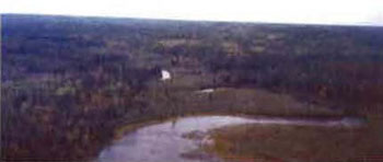
Looking south down Misema River along site’s western boundary. Tall shrub shore fen (floodplain) along river’s bank. Sb predominant conifer along edge. Harvested area beyond river reserve.
Photo 24_23 by Jane Nicholson, Sept. 22. 2003
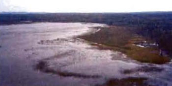
Grassy Lake southern shoreline, looking east Wetlands include tall will thicket swamp, bulrush marsh, shore fen, Sb predominant conifer along shoreline.
Photo 25_4 by Jane Nicholson, Sept. 22, 2003
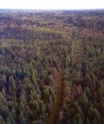
Snowmobile/ATV trail that cuts through the CR, just outside the site Forest communities are Sb, Sw and Po dominant.
Photo 25_3 by Jane Nicholson, Sept. 22, 2003
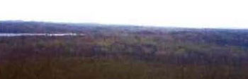
Taken from the south boundary (south of Grassy Lake), looking NE. Harvested area in foreground, with regeneration to Sw and Pj. Sw mixedwoods beyond harvest areas.
Photo 25_7 by Jane Nicholson, Sept. 22. 2003
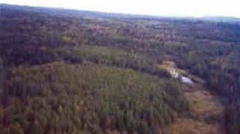
Tamarack stand (Ce dominant conifer in FRI) in the SE corner of CR. Meadow marsh/beaver marsh along Estrangement Creek.
C1626 South Grassy Lake Outwash CR Map 1a - Surficial geology
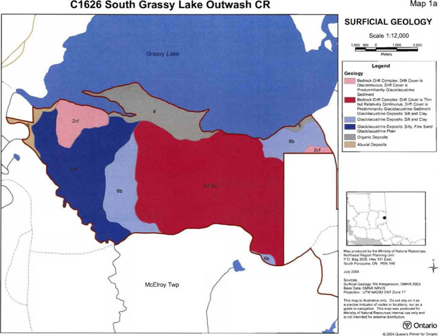
Enlarge South Grassy Lake Outwash Conservation Reserve surficial geology map 1a
C1626 South Grassy Lake Outwash CR landforms map 1b
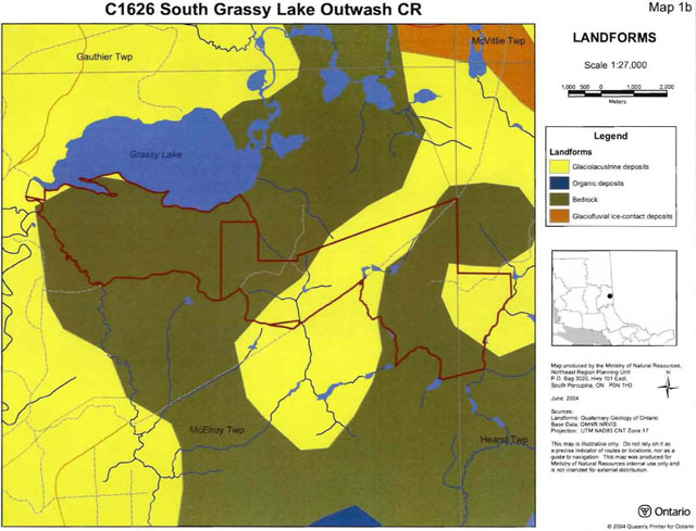
Enlarge South Grassy Lake Outwash Conservation Reserve landforms map 1b
C1626 South Grassy Lake Outwash CR forest communities map 2a
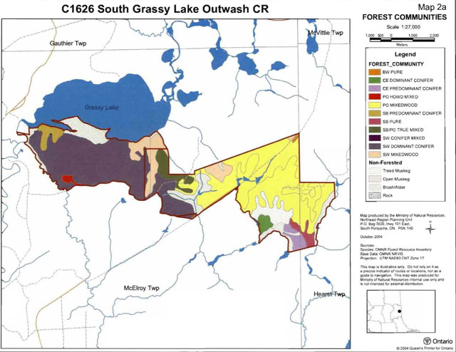
Enlarge South Grassy Lake Outwash Conservation Reserve forest communities map 2a
C1626 South Grassy Lake Outwash CR stocking distribution map 2b
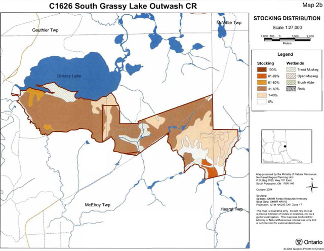
Enlarge South Grassy Lake Outwash Conservation Reserve stocking distribution map 2b
C1626 South Grassy Lake Outwash CR age distribution map 2c
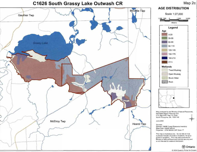
Enlarge South Grassy Lake Outwash Conservation Reserve age distribution map 2c
C1626 South Grassy Lake Outwash CR Standard Forest Units Map 2d
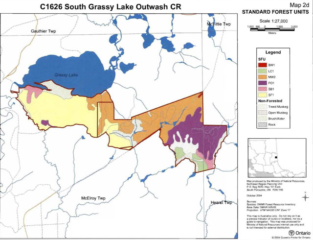
Enlarge South Grassy Lake Outwash Conservation Reserve Standard Forest Units map 2d
C1626 South Grassy Lake Outwash CR values map 3a
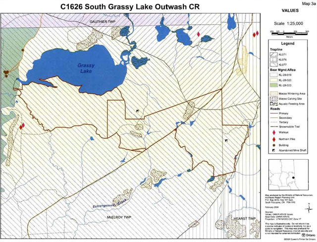
Enlarge South Grassy Lake Outwash Conservation Reserve values map 3a
C1626 South Grassy Lake Outwash CR wetlands map 3b
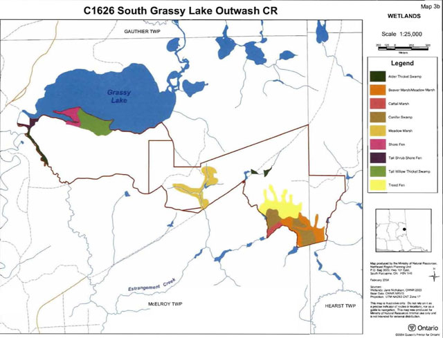
Enlarge South Grassy Lake Outwash Conservation Reserve wetlands map 3b
C1626 South Grassy Lake Outwash CR old growth map 5
Enlarge South Grassy Lake Outwash Conservation Reserve old growth map 5
C1626 South Grassy Lake Outwash CR Ecological considerations map
Enlarge South Grassy Lake Outwash Conservation Reserve ecological considerations map
C1626 South Grassy Lake Outwash CR History map
Enlarge South Grassy Lake Outwash Conservation Reserve history map
C1626 South Grassy Lake Outwash CR Landform vegetation combinations
Enlarge South Grassy Lake Outwash Conservation Reserve landform vegetation combinations map
Appendix 9: Earth science checksheet
South Grassy Lake Outwash Conservation Reserve (C1626)
Approved Earth Science Checksheet
Kirkland Lake
February 4, 2005
Prepared by: F.J. (Rik) Kfistjansson
Earth science inventory checklist
- Name: South Grassy Lake Outwash (C1626)
- Map Name: Larder Lake
- NTS Number: 32 D/04
- UTM Ref. (Datum): 590533
- Latitude: 48° 04′ 58″ N
- Longitude: 79° 47′ 15″ W
- Elevation (Min): 270 m asl
- Elevation (Max): 310 m asl
- Locality: Timiskaming
- Township(s): McElroy, and Hearst
- Area (ha): 425 ha
- MNR District: Kirkland Lake
- MNR Region: Northeast
- Aerial Photographs: 86-04, 4803, 117 to 120
- Prepared by: F.J. Kristjansson. Consulting Geoscientist
- Reviewed by: Phil Kor, Senior Conservation Geologist
- Date: February 4, 2005
Earth science features
Bedrock geology
With the exception of a wedge-shaped area located immediately south of Grassy Lake, the South Grassy Lake Outwash Conservation Reserve is underlain by undifferentiated igneous intrusive rocks of the Abitibi subprovince, Superior Province, Precambrian Shield. Referring to Map 2543 (Ontario Geological Survey, 1991), these rocks are classified as a “diorite-monzonite-granodiorite suite”. The wedgeshaped area, which occupies the north central, northeast, and east central parts of the conservation reserve, is underlain by undifferentiated metavolcanic rocks of the Abitibi Subprovince, Superior Province, Precambrian Shield.
Surficial geology
Based on a brief helicopter reconnaissance survey, review of surficial geological mapping (Baker and Storrison, 1979, Map P.2290), review of terrain geological mapping (Lee, 1979, Data Base Map 5031), and interpretation of available aerial photography, the South Grassy Lake Outwash Conservation Reserve is immediately underlain by areas of Bedrock-Drift Complex (Units 2df,6b and 2cf), Glaciolacustrine Deposits (Units 6b and 6ad), Alluvial Deposits (Unit 8), and Organic Deposits (Unit 9). Please refer to the attached preliminary surficial geological mapping for the occurrence and distribution of these surficial geological units within the conservation reserve (Appendix A).
A relatively extensive area of bedrock terrain, classified as Bedrock-Drift Complex (Units 2df,6b and 2cf), immediately underlies part of the northwest quadrant, most of the northeast quadrant, and much of the southeast quadrant. In addition, a small area of bedrock-drift complex, designated Unit 2cf, is located immediately south of Grassy Lake in the northwest quadrant. Minor bedrock exposure associated with a thin, but relatively continuous cover of glaciolacustrine silt and clay is anticipated within Unit 2df,6b. Subordinate, but difficult to delineate, areas immediately underlain by relatively thick, glaciolacustrine silt and clay are also very likely present within Unit 2df,6b. Moderate bedrock exposure associated with a discontinuous cover of glaciolacustrine silt and clay is expected within Unit 2cf.
Glaciolacustrine Deposits (Units 6b and 6ad) immediately underlie most of the remaining area of the conservation reserve. A moderately extensive area and a small area of glaciolacustrine silt and clay (Unit 6b) are situated immediately adjacent to the relatively extensive area of bedrock terrain described in the previous paragraph. These deposits represent the probably thicker, lateral equivalents of the fine-grained, glaciolacustrine deposits associated with the indicated area of bedrock terrain. As per Baker and Storrison (1979, Map P.2290), these deposits occur “in valleys and depressions surrounding rock outcrops”. A relatively extensive area of glaciolacustrine sand (Unit 6ad; Photo. C1626-01) occupies part of the southeast quadrant, most of the southwest quadrant, and much of the northwest quadrant of the conservation reserve. These deposits have been reworked by wind activity, and a number of sand dune forms are present in the southwest part of the conservation reserve.
Finally, the conservation reserve contains a small area of Alluvial Deposits (Unit 8; Photo. C1626-02), and several small areas of Organic Deposits (Unit 9; Photo. C1626-01).
Significance:
The geological features described above are commonly encountered within the surrounding region, and are considered to be of local significance.
Sensitivity:
Considering the relatively passive land uses anticipated within a conservation reserve, the various geological features are considered to have low sensitivity.
Recommendations:
None
References:
Baker, C.L., and Storrison, D.J., 1979; Quaternary Geology, Larder Lake Area, District of Timiskaming; Ontario Geological Survey, Preliminary Map P.2290, Geological Series, Scale 1:50,000. Geology 1978.
Lee, H.A., 1979; Northern Ontario Engineering Geology Terrain Study, Data Base Map, Larder Lake; Ontario Geological Survey, Map 5031, Scale 1:100,000.
Ontario Geological Survey, 1991; Bedrock Geology of Ontario, East-Central Sheet; Ontario Geological Survey, Map 2543, Scale 1:1,000,000.
Appendices:
Appendix A: Preliminary Surficial Geology of the South Grassy Lake Outwash Conservation Reserve (C1626) [please see above]
Footnotes
- footnote[1] Back to paragraph Mixedwoods are defined as follows: hardwood mixedwoods are stands dominated by hardwoods with less than 30% cover of conifer in the main canopy; similarly conifer mixedwoods contain less than 30% hardwoods in the canopy. Mixedwoods contain approximately equal percentages of conifer and hardwood trees and true mixedwoods contain a 50:50 split between conifers and hardwoods (modified after Taylor et al. 2000).
- footnote[2] Back to paragraph Conifer stands are defined as follows: pure conifer stands contain 100% of a conifer trees in the canopy; dominant conifer stands contain less than 10% cover of hardwoods in the main canopy and predominant conifer stands contain less than 20% cover of hardwoods in the main canopy. Similarly hardwood stands may contain no conifer in canopy (pure hardwood), less than 10% conifer (dominant hardwood) or less than 20% conifer cover (predominant hardwood) (modified after Taylor et al. 2000).
- footnote[3] Back to paragraph 3 Wetlands were classified after Arnup et al. 1999 and Harris et al. 1996.
- footnote[4] Back to paragraph Rating based on the amount of area currently under some form of known disturbance. High is > 20% of the area, medium 10 to 20%, low < 10% and pristine < 1 %.
- footnote[5] Back to paragraph Diversity rating, developed by John Thompson & Jake Noordhof (2003), is based on the size of the conservation reserve versus the number of landforms:vegetation (SFU’s/HU) combinations. For CR’s <500 ha, high diversity is >25 L:V combinations, medium for >15 L:V, and low for <15 L:V. For areas 500- 2000 ha, high is >30, medium >20 and low <20. For areas >2000 ha, high >35, medium >25 and low <25 L:V combinations.
- footnote[6] Back to paragraph Evenness of the site defined as strongly skewed (top 3 communities capture >=60% of the site in area), moderately skewed (30-59%) or slightly skewed to even (<30%).
- footnote[7] Back to paragraph Coordination could include a variety of expertise from the following: Field Services Division, Ontario Parks, Aviation and Forest Fire Management Branch, Forest Health and Silvicultural and Forest Management Planning Sections, Northeast Science and Information etc. Additional expertise within and outside the MNR could be sought as required.
- footnote[*] Back to paragraph Modified total are those areas that account for >1% hectares in the conservation