Temagami Area Park Management Plan for Lady Evelyn-Smoothwater, Makobe-Grays River, Obabika River, Solace and Sturgeon River Provincial Parks
This document provides policy direction for the protection, development and management of Lady Evelyn-Smoothwater, Makobe-Grays River, Obabika River, Solace and Sturgeon River Provincial Parks and their resources.
© 2007, Queen’s Printer for Ontario
The Ojibwe term "Chee-bay-jing" refers to the place where the sun sets - where life ends and the spirit dwells. This site is sacred to the First Nation communities of the Temagami area.
Electronic copies of this publication are available at:
http://www.ontarioparks.com/english/tema_planning.html (Link no longer active)
Additional print copies of this publication are obtainable from the Ministry of Natural Resources at the Finlayson Point Provincial Park office:
Finlayson Point Provincial Park
P.O. Box 38
Temagami ON P0H 2H0
Telephone:
52090
(1.5k 31/07/07)
ISBN 978-1-4249-4375-3 (Print)
ISBN 978-1-4249-4376-0 (PDF)
Cette publication est également disponible en francais.
Dear Sir/Madam:
I am pleased to approve the Temagami Area Park Management Plan as the official policy for the protection and management of five parks in this significant area. The five parks are: Lady Evelyn-Smoothwater (wilderness class) Makobe-Grays River, Obabika River, Solace, and Sturgeon River (all waterway class parks). The plan reflects the Ministry of Natural Resources' and Ontario Parks' intent to protect the parks' natural and cultural features while maintaining and enhancing high quality opportunities for outdoor recreation and heritage appreciation for the residents of Ontario and visitors to the Province.
The plan includes implementation priorities and a summary of the public consultation that occurred as part of the planning process.
The plan for the Temagami Area Provincial Parks will be used to guide the management of these five parks. It may be reviewed to address changing issues or conditions.
I wish to extend my sincere thanks to all those who participated in the planning process.
Yours truly,
Signed by:
Adair Ireland-Smith
Managing Director
Ontario Parks
Context
Statement of Environmental Values and Environmental Bill of Rights
In 1994, the Ministry of Natural Resources (MNR) finalized its Statement of Environmental Values (SEV) under the Environmental Bill of Rights (EBR). The SEV is a document that describes how the purposes of the EBR are to be considered whenever decisions are made in the Ministry that might significantly affect the environment. This includes decisions made as a result of the park management planning process.
The primary purpose of the EBR is to protect, conserve and, where reasonable, restore the integrity of the environment. From the Ministry’s perspective, that broad statement of purpose translates into four objectives in its SEV:
- to ensure the long-term health of ecosystems by protecting and conserving our valuable soil, aquatic resources, forest and wildlife resources as well as their biological foundations
- to ensure the continuing availability of natural resources for the long-term benefit of the people of Ontario
- to protect natural heritage and biological features of provincial significance; and
- to protect human life, the resource base, and physical property from the threats of forest fires, floods and erosion
The Ministry’s SEV has been considered throughout the planning process. The Temagami Area Provincial Parks Management Plan will further the objectives of managing Ontario’s resources on an environmentally sustainable basis.
Planning context
The Temagami area, located 100 km north of North Bay, covers approximately 650,000 hectares of varied and rugged terrain. Much of the area is relatively remote, offering solitude and challenge for those seeking a backcountry recreation experience.
Temagami has been a tourist destination for over a century, and with over 2,400 kilometers of interconnecting canoe routes and portage trails it is considered one of North America’s premier canoeing destinations. The area attracts local residents as well as visitors from provincial, national and international markets. Recreational use is quite high, with a 1994 survey estimating over 60,000 visitor days of wilderness canoeing and other backcountry use. Use is expected to increase with growing interest in adventure travel and relatively accessible wilderness experiences. The majority of travel into the core parks and conservation reserves occurs from Crown land access points that are a considerable distance away from the protected areas. Often, recreational users travel in and out of parks, CRs and Crown land continuously, unaware of the land use designations they cross.
Five provincial parks covering 104,248 hectares lie in the western part of Temagami. Surrounding the parks are eight conservation reserves which make up an additional 42,836 hectares of protected area. The remaining land base consists of unregulated Crown lands.
Major land use decisions and management direction for the Temagami area were outlined in the 1997 Temagami Land Use Plan (TLUP). This document reaffirmed Temagami’s existing provincial parks and identified four primary land use zones for the entire Temagami area: Protected Areas, Special Management Areas, Integrated Management Areas, and Developed Areas. These four types of zones are subdivided into 59 specific management areas. The 1997 TLUP continues to provide the overall direction for the management and use of natural resources within each specific management area. Ontario Parks planning and management policies and directives provide the overall planning context and management direction specific for the parks.
The Temagami Land Use Plan provides direction to develop management plans for the provincial parks and conservation reserves. In addition, the TLUP provides direction to develop a plan to manage the increasing recreational use of the area’s unregulated Crown lands (i.e., not regulated as a provincial park or conservation reserve).
In 2004, the Temagami Integrated Planning (TIP) process followed through on several commitments from the 1997 Temagami Land Use Plan. This planning process combined the planning requirements for the five parks and eight adjacent conservation reserves as well as planning for recreation management on Crown lands in the Temagami area.
TIP resulted in three separate planning documents: a "parent" park management plan for the five provincial parks (this document); a resource management plan for the eight conservation reserves, and a Crown land recreation plan for the Temagami area. Some of the work to implement these plans requires ongoing integration between these land use areas; please refer to all three documents for management direction.
Aboriginal context
For more than 6,000 years, aboriginal inhabitants have lived in the Temagami area, travelling by way of an interconnected system of winter and summer trails and portages. Temagami lies within Daki Menan, the ancestral homeland of the Teme-Augama Anishnabai—the deepwater people. Many sacred sites are found within the area, and the landscape of Temagami continues to hold great cultural, spiritual and economic significance for First Nation communities. Present-day First Nation communities include Bear Island on Lake Temagami and Matachewan on the Montreal River. A strong tradition of stewardship continues today through ceremonies, culture and language, and the spirit of the land is cared for by the original keepers of the land.
It is mutually understood that any communications and cooperation between the Temagami or Matachewan Aboriginal communities and MNR/Ontario Parks for planning and operations purposes as part of this park management plan, are undertaken without prejudice to any ongoing or future discussions or negotiations between the government of Ontario and these Aboriginal communities.
Nothing in this plan shall be construed so as to abrogate or derogate from the protection provided for the existing Aboriginal or treaty rights of the Aboriginal people of Canada as recognized and affirmed in section 35 of the Constitution Act, 1982.
1.0 Introduction
The Temagami area is renowned for its rugged landscape and significant natural, cultural and recreational resources. Approximately one sixth of Temagami’s land base (104,248 hectares) has been regulated as wilderness or waterway provincial parks. Eight conservation reserves about the parks and offer an additional 42,836 hectares of protected area.
The majority of travel into the one wilderness and four waterway parks occurs from access points a considerable distance away. Many canoe routes start or finish well outside of park boundaries on adjacent Crown lands.
The five parks became operational in 2004 with the introduction of interior overnight camping fees and the hiring of interior wardens to undertake maintenance, education and compliance work along canoe routes. Fees collected cover the costs of maintaining portages, campsites, privies and overall compliance throughout all five parks.
The five parks share a common theme in that they provide remote wilderness experiences. The parks have minimal facilities and staffing assigned to them. The intent of the management plan is to manage visitor use, protect significant natural and cultural resources, and ensure that park operations are environmentally, socially and economically sustainable.
The park management plan provides policy direction to manage the following five parks in the Temagami area: Lady Evelyn-Smoothwater (Wilderness class), Makobe-Grays River, Obabika River, Solace, and Sturgeon River (all Waterway class parks).
Typically, management plans are developed for individual parks. In this case, the park management plan is combined for all five parks since they are physically connected to each other and share similar patterns of use. This plan format is termed a "parent plan".
The management plan sets the direction for the zoning, management and operation within the five parks. The plan will be for a 20-year period. Every 10 years, or as required, the plan will be assessed to determine if an amendment to the plan is required. It serves as a working guide on which to base sound management actions into the future. While this plan provides overall direction for management, specific actions will be further developed in subsequent implementation plans.
This management plan has been developed in accordance with the Ontario Provincial Parks Planning and Management Policies (1992), and the Temagami Land Use Plan (1997). In accordance with this plan, MNR will amend affected area-specific land use policies and mapping found in the Crown Land Use Policy Atlas.
1.1 Lady Evelyn-Smoothwater Wilderness Park
The Lady Evelyn River was first designated as a Wild River (now Waterway) class park in 1973. It was expanded to its present size of 72,400 hectares and designated a Wilderness class park in 1983. The park’s rugged topography encompasses many high ridges such as Maple Mountain and Ishpatina Ridge—the highest point in Ontario. The park contains significant geological, biological and cultural features. The park includes the only two lakes-of-origin of the endangered Aurora trout, a species-at-risk which is considered provincially significant.
Maple Mountain is known as a place of great spiritual significance for Temagami’s First Nation communities. The earth and life science features of this high ridge are regionally significant.
1.2 Four adjoining waterway parks: Makobe-Grays River, Obabika River, Solace, and Sturgeon River Provincial Parks
The Makobe River flows northward from headwaters within the wilderness park. To the west, Solace Provincial Park encompasses a chain of lakes. To the east and south, Obabika River Provincial Park includes a number of large lakes and the Obabika River. It also contains old growth pine forests and a significant bog area. To the southwest, the Sturgeon River flows from areas within, and to the west of, Lady Evelyn-Smoothwater.
The provincially significant Obabika Lake red and white pine forest contains a diverse collection of old growth forest communities on a variety of landforms and soils in a relatively undisturbed area.
Other significant sites and features within the five parks are outlined in the previously released Temagami Integrated Planning: Background Information document.
2.0 Classification
Ontario’s provincial parks are organized into broad categories or classes, each of which has particular purposes and characteristics. All of Ontario’s provincial parks fall into one of six classes: wilderness, nature reserve, historical, natural environment, waterway or recreation. Each class contributes differently towards the provincial park system while collectively ensuring that the province’s natural, cultural and recreational environments are protected.
Lady Evelyn-Smoothwater Provincial Park is a wilderness class park. Wilderness parks protect large areas where the forces of nature function freely and where visitors travel by non-mechanized means and experience solitude, challenge and personal integration with nature.
The four adjacent provincial parks—Makobe-Grays River, Obabika River, Solace and Sturgeon River—are all waterway class parks. Waterway parks protect recreational water routes and representative and significant terrestrial and aquatic ecosystems and associated natural and cultural features and to provide high quality recreational and educational experiences.
3.0 Goal
The overall goal of Ontario Parks is to provide a variety of outdoor recreation opportunities and to protect provincially significant natural, cultural and recreational environments in a system of provincial parks.
The five parks are governed by the Provincial Parks Act, Ontario Provincial Parks Planning and Management Policies (1992) and Ontario Provincial Parks Operations Policies.
4.0 Objectives
There are four objectives for the Ontario provincial parks system: protection, recreation, heritage appreciation and tourism.
- Protection: to protect provincially significant elements of the natural and cultural landscape of Ontario
- Recreation: to provide Provincial Park outdoor recreation opportunities ranging from high-intensity day-use to low-intensity wilderness experiences
- Heritage Appreciation: to provide opportunities for exploration and appreciation of the outdoor natural and cultural heritage of Ontario
- Tourism: to provide Ontario’s residents and out-of-province visitors with opportunities to discover and experience the distinctive regions of the province
Lady Evelyn-Smoothwater Provincial Park is one of eight wilderness class parks within the province. It meets the wilderness class target for Ecoregion 4E and plays an important role in the achievement of wilderness targets for the provincial parks system.
Lady Evelyn-Smoothwater fits into this system by protecting an outstanding wilderness landscape, natural features and cultural resources, and by providing high quality recreational and educational experiences.
Similarly, the four adjoining waterway parks protect a range of resources as well as providing high quality recreational and educational experiences. They offer a physical link with the core wilderness park as well as a continuation of the backcountry experience in the Temagami area.
5.0 Park boundaries
Four of the five parks lie within the Temagami Area of MNR's North Bay District. To the north, Makobe-Grays River Provincial Park is located within Kirkland Lake District. To the west, Sturgeon River Provincial Park forms the boundary between Sudbury and North Bay MNR districts but lies within North Bay District.
Key details about the individual park boundaries are outlined below. Further information can be obtained from the 2005 Background Information document.
- Lady Evelyn-Smoothwater Provincial Park: 72,400 hectares, regulated 1983, O. Reg. 343/83
- Makobe-Grays River Provincial Park: 1,427 hectares, regulated 1985, O. Reg. 45/85
- Obabika River Provincial Park: 20,520 hectares, regulated in 1988, amended in 1996, O. Reg. 52/97
- Solace Provincial Park: 5,943 hectares, regulated 1988, O. Reg. 256/89
- Sturgeon River Provincial Park: 3,350 hectares, regulated 1985, O. Reg. 256/89
Park management planning policies apply only to the area within the regulated boundary of a park. Within the park boundary, the protection of park values and features will be achieved through appropriate zoning, control of land use and activities, visitor education, research and monitoring of ecological impacts.
Ontario Parks is committed to an ecosystem approach to park planning and management. The Provincial Parks Act, which governs activities within provincial parks, pertains only to lands and waters within park boundaries. An ecosystem approach allows park management to consider the relationship between the park and the surrounding environment. Park managers may consider potential impacts on park values and features from activities occurring on adjacent lands, and potential impacts from park activities on land uses in adjacent areas. Ontario Parks will encourage efforts of adjacent landowners to protect significant natural and cultural features outside park boundaries.
Ontario Parks will work closely with the MNR districts in the area to protect significant natural and cultural features outside park boundaries and to enhance the backcountry recreational experience throughout the entire area. This will include ongoing cooperation in the integration of backcountry maintenance as well as contributing in the forest management planning process, annual work schedules and resource management plan reviews.
Ontario Parks will support in principle the acquisition of property for the purposes of addition to the park, if acquisition will enhance the values of the park. Acquisition or securement will be subject to funding and willingness of the owners to sell or lease their properties or enter into a conservation easement.
6.0 Zoning
6.1 Zone types within the Temagami backcountry parks
Four zone types have been designated for the wilderness and waterway parks within this management plan: Wilderness, Nature Reserve, Access and Natural Environment. Natural Environment zones are found only in the waterway parks. No Historical zones have been identified at this time but may be included in the future as required.
Wilderness Zones include wilderness landscapes of appropriate size and integrity which protect significant natural and cultural features and are suitable for wilderness experiences. They support back-country recreation such as canoeing or hiking. Development is limited to wilderness campsites, portages, trails and signs necessary for route identification. Wilderness campsites (canoe- or hike-in) are established at a very low density and offer limited facilities such as designated fireplaces and pit privies, in keeping with the character of the landscape which the zone protects.
Resource management policies are directed where possible toward achieving minimum human intervention and the maintenance of evolving natural succession.
Nature Reserve Zones protect provincially significant earth and life science features which require management distinct from that in adjacent zones, and permit minimal development. Development is generally restricted to trails, necessary signs, interpretive facilities (where warranted) and temporary facilities for research and management.
Natural Environment Zones include natural landscapes which permit the minimum level of development required to support low-intensity recreational activities. Development is generally limited to backcountry campsites, portages, signs and minimal self-use interpretive facilities.
Resource management policies for natural environment zones may be more permissive than those for wilderness and nature reserve zones in allowing human intervention to maintain or improve aesthetics, wildlife habitat, etc.
Access Zones serve as staging areas where minimum facilities support use and access to nature reserve or wilderness zones and natural environment zones. Access zones provide, and regulate, use in areas of a park geared towards more extensive recreation. Development is generally limited to roads, visitor control structures and group campgrounds. There may be limited orientation, interpretive or educational facilities, which are generally self-use. Limited facilities for research and park management may also be present.
Infrastructure is intended to meet the needs of park visitors entering or exiting from the park’s interior. As such, only very basic facilities are provided. Throughout the five parks in Temagami’s backcountry (wilderness and waterway) the overall intent is to provide minimal facilities in order to preserve the remote backcountry experience.
6.2 Individual park zoning
While each park in this management plan is a distinct, regulated provincial park, the zoning designations have been identified at a broader level across all five parks; the numbering of zones has been combined for the sake of clarity and simplicity. For example, all Access zones use the same continuous numbering system across all five parks (e.g. A1, A2, A3 carries on throughout all the parks).
For an area of such size, the number of access zones within the five parks is minimal since much of the access into the parks originates well beyond the park boundaries. Many backcountry trips typically begin on Crown land outside of the parks, with the trip extending into the parks.
Throughout the plan, zoning designations predominantly delineate differences in management direction rather than providing a detailed delineation of landform/vegetation associations.
In this section, individual zones are described and the overall management intent outlined. Management direction specific for each zone is provided, however this should be read in conjunction with the broader management direction provided in sections 7 to 10 in this document. These broader sections of provincial park policy—Resource Management, Operational, Marketing and Communications, and Development Policies—provide further management direction as well as permitted or prohibited activities.
6.3 Lady Evelyn-Smoothwater Provincial Park
The wilderness park is comprised of one Wilderness zone, two Nature Reserve zones and six Access zones.
NR1 Aurora Watershed Nature Reserve Zone (Map 3) 1,125 hectares
Zone Description: this relatively small watershed lies perched upon one of the higher ridges within the park. The nature reserve boundary is defined by the sub-watershed boundary and includes Whitepine, Little Whitepine, Whirligig and Aurora lakes. Whitepine and Whirligig lakes are the lakes-of-origin for the endangered Aurora trout, which is identified as a species-at-risk in Ontario. Both lakes are designated as fish sanctuaries.
There is an extensive history of research and active management on the lakes within this watershed. The Nature Reserve designation highlights this area of particular sensitivity and recognizes the requirement for further research and management to protect this species-at-risk which is unique to Lady Evelyn-Smoothwater Provincial Park.
Management Intent: to provide enhanced protection to the only known native lakes of the Aurora trout (Salvelinus fontinalis timagamiensis), a distinctly coloured form of brook trout. This Nature Reserve zone includes the native lakes and their headwaters
Zone-Specific Management Direction:
- maintain fish sanctuary status of Whitepine and Whirligig lakes, no angling permitted
- camping is not permitted except where authorized by the park superintendent for research and management purposes
- hunting is prohibited
- motorized travel is prohibited except for aircraft landings or motor boat use as authorized by the park superintendent for research purposes
- active research and monitoring to support management of aurora trout and its habitat is encouraged. Research and monitoring will be permitted to continue under a Memorandum of Understanding between Ontario Parks and the Cooperative Freshwater Ecology Unit.
- management of aurora trout is permitted per the Aurora Trout Recovery Strategy
NR2 Chris Willis Peatland Nature Reserve Zone (Map 3) 1,171 hectares
Zone Description: this extensive peatland complex consists of forested and stabilized sand dunes interspersed with a range of peatland communities. The dominant landform is an extensive aeolian deposit characterized by sand dunes that are now stabilized by vegetation. This diverse area includes representative examples of all five major wetland groups, including swamps, fens, bogs, marshes and shallow water wetlands. The dunes are covered by upland mixed forests of Black Spruce and Jack Pine. In contrast to the dunes on Lady Evelyn Lake (in East Lady Evelyn Lake CR), these dunes have been little affected by elevated lake water levels.
The Nature Reserve zone encompasses the peatland complex and associated wetlands; note that the navigable waters in the west bay of Sucker Gut Lake within the wilderness class park are included as part of Wilderness zone W1.
Management Intent: to protect the extensive peatland that occurs north of Chris Willis Lake.
This provincially significant peatland is sensitive to human activities. The navigable waters of the west bay of Sucker Gut Lake (known locally as "Betty’s Hole") are part of Wilderness zone W1. The management intent in this specific area is to enable existing angling use to continue with restrictions to protect the adjacent wetland.
Zone-Specific Management Direction:
- camping is prohibited (the existing campsite to be closed)
- hunting is prohibited
- aircraft landings are prohibited
- motorized travel is not permitted
W1 Ish-pud-in-ong Wilderness Zone (Map 3) 69,976 hectares
Zone Description: this wilderness zone forms the core of Lady Evelyn-Smoothwater Provincial Park and encompasses many of the values for which the Temagami area is known. The name for this zone embodies the spirit of Temagami’s aboriginal heritage. An Ojibwe name meaning "the place that stands above all others", it is a direct reference to the ridge—Ishpatina—which is the highest point in the province (2,275 feet, or 693 metres, above sea level).
The zone contains other high ridges—Maple Mountain (Chee-bay-jing), Dry Lake Ridge, and a number of high points in the Florence Lake area—that offer excellent viewpoints of Temagami’s rugged landscape. Ishpatina Ridge and Maple Mountain have forest fire lookout towers at their summits; these historic structures are accessible by foot trails from the lakes below. Trails in the zone are accessible only from the parks' canoe routes and form part of the "wilderness experience" sought by many visitors.
Vegetation ranges from cliff and rock barrens to partially open bogs, fens and aquatic communities to upland coniferous, mixed and deciduous forests. The area is well known for its remaining stands of old growth red and white pine ecosystems. Natural disturbances, such as wind throw and fire are evident in the vegetation mosaic of this wilderness zone.
Running through the zone’s rugged landscape is the Lady Evelyn River system. From the west two branches flow eastward, converging into a main channel; this scenic river with multiple pools and rapids is known historically as "the Trout Streams". The river then divides again into two channels, flowing over a series of waterfalls known as "the Golden Staircase". Both channels flow into Willow Island and Suckergut lakes, part of the large Lady Evelyn Lake system to the east of the park.
The Lady Evelyn River is an important Brook trout fishery. Throughout the wilderness zone, many other lakes provide important Lake trout habitat. These lakes vary in size and are interspersed throughout the zone. Key Lake trout lakes include Anvil, Banks, Dees, Jerry, Grays, Makobe, Marina and McGiffin lakes (two other Lake trout lakes are designated as access zones). In addition the western portion of Sucker Gut Lake which lies within this zone is well known as a warm water fishery (smallmouth bass, walleye).
As the largest zone within the Temagami area parks, this wilderness zone contains a range of prehistoric and historic landscapes and sites sacred to Temagami’s First Nations. For reasons of security and cultural sensitivity, these sites are incorporated within the greater wilderness zone rather than identified as individual historic zones.
Management Intent:
- maintain/enhance the ability for natural processes to function freely, to continue unimpeded by human intervention where possible
- maintain remote, wilderness experience
- minimize user impacts upon the environment
- minimize conflicts between users
- rehabilitate and restore damaged ecosystems (aquatic, terrestrial)
- enable limited, seasonal motorized use through seasonal access zones in specified areas, with restrictions to ensure sustainable recreational use and the protection of park resources
Zone-Specific Management Direction:
- natural ecological process will be permitted to function with minimal human intervention where feasible
- development will be limited to the construction or upgrading of backcountry campsites, privies, trails and portages as required to ensure visitor safety and to prevent environmental degradation
- unauthorized access from resource access roads outside of the zone is prohibited
- the Liskeard Lumber Road will be closed at the south boundary of the A2 Access zone and the road south of this point will be decommissioned
- all unauthorized roads and trails will be closed and rehabilitated to a natural condition, or a condition which promotes natural regeneration
- hunting is prohibited
- motorized travel within the wilderness zone is prohibited, except as permitted through seasonal access zones (see A1S, A2S and A5S). Motor boats, with a 25 hp limit, are permitted in designated waters within the western portion of Sucker Gut Lake (known locally as "Betty’s Hole") only
- aircraft landings are prohibited except for authorized commercial tourism on Chris Willis, Florence, Grays, Hobart, Katherine and Scarecrow lakes
- the emergency landing of aircraft in distress is permitted, as is aircraft access to provide assistance to persons in distress
- use of aircraft for parks management and research will be minimized where possible to reduce potential impacts on the wilderness experience
A1 Smoothwater Lake Access Zone (Map 3) 948 hectares
Zone Description: Smoothwater Lake is one of the largest and deepest lakes within the park and provides excellent lake trout habitat. Open water access is by boat via the Montreal River, which flows northward out of the park. The nearest boat launch on the river is at the Beauty Lake Road, eight kilometers north of the park boundary. The shallows at the mouth of the river restrict the size of boats which can pass into the park. Winter access by snowmobile follows the Montreal River, with land sections along the northeast shore to bypass open water and thin ice.
Management Intent: to provide access to the park for canoeing, angling and limited motorized use.
Zone-Specific Management Direction:
- motorboats to a limit of 25 hp are permitted on Smoothwater Lake and the portion of the Montreal River within the park boundary
- snowmobiles are permitted within the zone for the purposes of winter recreation and to follow the authorized snowmobile trail which extends southward through the seasonal access zone A1S (see below)
- no travel off of the frozen lake surface will be permitted. Off-trail travel to areas outside the zone are prohibited
- management direction for the use of the snowmobile trail through the seasonal access zone A1S shall also apply (see below)
- private and commercial aircraft landings are permitted throughout all seasons
- no ATVs or other motorized vehicles are permitted
- hunting is prohibited
- no ice huts are permitted
A1S Seasonal Access Zone: Existing Snowmobile Trail East of Ishpatina Ridge (Map 3) 26 hectares
Zone Description: this winter season access zone covers the existing snowmobile trail which crosses the western portion of the park, east of Ishpatina Ridge, through Smoothwater, Apex, McCulloch, Mihell and Scarecrow lakes and the associated canoe portages.
Management Intent: to enable winter season snowmobile travel along the existing trail while maintaining the wilderness character of the canoe route. An alternate route for the trail outside of the park will continue to be explored.
Zone-Specific Management Direction:
The snowmobile trail is permitted to continue with the following conditions:
- winter use by snowmobiles only (no ATVs permitted)
- the trail is designated as a winter season access zone, reverting to wilderness zone in non-winter season
- winter season dates will be determined by the superintendent
- snowmobile travel on the designated trail only; no off-trail travel permitted
- trail maintenance is limited to the removal of deadfall along the trail. No widening of the existing trail is permitted
- markers and signage for snowmobile trail use will be permitted as designated by the park superintendent; temporary markers placed on lake surfaces must be removed before the end of each season
- educational materials will be developed in cooperation with the local snowmobiling community to promote the safe, sensitive use and best practices for maintenance of this seasonal trail
- alternative route options to the west of the park boundary will continue to be explored utilizing existing tertiary forestry roads where possible. When there is a viable alternative, the existing snowmobile trail within the park will be relocated and closed
A2 Gamble Lake Access Zone (Map 3) 189 hectares
Zone Description: this linear access corridor utilizes a portion of the former Liskeard Lumber Road within the park. The access zone extends from the north boundary six km. southward along the road to Chalice Creek, forming a corridor to a staging area for canoeists adjacent to Gamble Lake and a small boat launch site at Chance Lake.
Management Intent: to enable recreational access into the wilderness park, specifically to the Lady Evelyn River system, while protecting core areas in wilderness zone W1. The staging area and boat launch site are designed to allow small car-top boats to access beyond A2 into the A2S seasonal access zone of the Lady Evelyn River.
Zone-Specific Management Direction:
- motor vehicles are permitted to travel only on designated roadways within the Access zone. ATV travel is permitted on the designated road only within this zone. Off-road use of ATVs or other motor vehicles is prohibited
- the road will lead to a staging area adjacent to Gamble Lake. The staging area will be developed to provide for parking, day use and limited camping facilities as well as signage for backcountry information
- a small boat launch area will be developed within the A2 zone at Chance Lake to enable access to the Lady Evelyn River. Controlled access for the use of car-top boats to the east bank of the Lady Evelyn River will be provided at this point (see also Use of Motor Boats on the Lady Evelyn River in A2S below)
- a managed boat cache at Chance Lake will be implemented; use of the cache will be encouraged in order to minimize the introduction of invasive species into the Lady Evelyn River system
- Ontario Parks is not responsible for road maintenance outside the park boundary
- Road maintenance inside the Access zone to Chalice Creek will be limited to preventing environmental degradation within the park (e.g. erosion, siltation etc.), protecting park values and to ensure visitor safety
- Road sections which are closed will be decommissioned and rehabilitated
- snowmobiles are permitted along the existing roadway to the intersection with the seasonal trail in A3 for the purposes of accessing the Trethewey Lake Access Zone (A4). Snowmobile travel beyond the A3 trail is prohibited
- hunting is prohibited
A2S Seasonal Access Zone: Motor Boat Use on Lady Evelyn River (Map 3) 131 hectares
Zone Description: this open-water season access zone consists of the North Branch of the Lady Evelyn River from the Gamble Lake Access Zone (A2 above) downstream to the first rapids south of the current bridge location. The latter portion, from the confluence of the North and South Branches, downstream to the rapids, is part of the Main Channel. This seasonal access zone does not include river segments upstream or downstream of the described area, and does not include the South Branch of the river.
Management Intent: to support limited motor boat use while protecting the aquatic ecosystems and recreational character of the Lady Evelyn River and to protect the native brook trout fishery. This seasonal access is limited the open water season for brook trout: beyond this season, this section of river reverts to W1 zone.
Zone-Specific Management Direction:
- motor boat use to a maximum of 10 hp, is permitted on the North Branch of the Lady Evelyn River from the Gamble Lake Access Zone (A2) downstream to the first rapids south of the current bridge location
- season dates will be determined by the open water season for brook trout per the Ontario Fishing Regulations
- ongoing research and monitoring will be undertaken to assess the health of the river’s fisheries and aquatic ecosystems. If it is determined that motor boat use or angling activities are detrimental to the brook trout fishery, further restrictions may be implemented
- motors are prohibited on all other sections of the river except Zone A6 (page13)
- a managed boat cache will be designated at Chance Lake in the Gamble Lake Access zone (A2 above) to minimize the introduction of invasive species into the river system
- no other motorized vehicles are permitted
- hunting is prohibited
A3 Trethewey Trail Access Zone (Map 3) 65 hectares
Zone Description: this 1-kilometer long corridor extends eastward from the Gamble Lake access zone (A2) along an existing walking trail through low, wet areas to a small lake to the southwest of Trethewey Lake (A4). The zone is delineated as a 500-metre wide corridor to enable alternate trail re-routing to the north as feasible.
Management Intent: to provide access from A2 to A4 while protecting the sensitive wetland environment found to the west of Trethewey Lake. Seasonal motorized access (winter snowmobile use only) and non-winter access will be permitted by foot only along the existing designated trail to the Trethewey Lake access zone (A4).
Zone-Specific Management Direction:
- the trail is designated as a walk-in trail only during the non-winter months
- the existing trail will be rerouted to higher ground to the north as feasible
- snowmobiles are permitted on the trail in the winter season to access Trethewey Lake for recreation purposes
- off-trail snowmobile travel is prohibited
- no ATVs or other motorized vehicles are permitted
- hunting is prohibited
A4 Trethewey Lake Access Zone (Map 3) 621 hectares
Zone Description: this zone includes all waters within Trethewey Lake and the small un-named lake to the southwest. It does not include the chain of small lakes which extend to the northeast of Trethewey Lake.
Management Intent: to provide for continued angling opportunities while protecting the lake’s aquatic environment and maintaining a healthy, self-sustaining lake trout population within Trethewey Lake.
Zone-Specific Management Direction:
- boat access is permitted through a managed cache system at a location to be determined nearby the existing boat cache
- boats cached under the managed cache program will require a registration number. Unregistered or abandoned boats will be removed at the owners expense. Transport of boats to or from the cache through A3 shall occur only through the winter season.
- motor boat use is permitted during the open water season with a maximum 10 hp limit
- private and commercial aircraft access is permitted throughout all seasons
- motorized access by snowmobile is permitted during the winter months
- all other forms of motorized access or use are prohibited
- hunting is prohibited
- no ice huts are permitted
A5 Makobe Lake Northwest Shore Access Zone (Map 2, Map 3) 5 hectares
Zone Description: situated on the northwest shoreline of Makobe Lake’s north basin, this small access zone is located at the park boundary. This access zone can be reached by an unmaintained forest access road which runs 10 km southeastward from the Liskeard Lumber Road at Southbear Lake to the park boundary. The road will not be maintained by MNR as the primary purpose of the zone is to provide winter access by snowmobile.
Management Intent: to provide access to the north and central basins of Makobe Lake. All three basins of Makobe Lake lie within wilderness zone W1, however winter motorized access will be permitted in the north and central basins only (see A5S, below).
This access zone is along the periphery of the park boundary and is accessed by the unmaintained forest access road on adjacent Crown land in Kirkland Lake District. The long- term status of the road is undetermined. There is no intent on the part of MNR or Ontario Parks to provide any form of maintenance of this road. The primary purpose of this access zone is to enable winter access by snowmobile.
Zone-Specific Management Direction:
- motor vehicle use is permitted for access purposes only
- snowmobiles are permitted beyond the access zone into the north and central basins of Makobe Lake in the winter season (see A5S Seasonal Access Zone below)
- hunting is prohibited
A5S Seasonal Access Zone: Snowmobile Use on Makobe Lake (Map 3) 1,772 hectares
Zone Description: this winter-season access zone includes the lake surface of the north and central basins of Makobe Lake. The seasonal zone applies to the north and central basins only, reverting to wilderness zone W1 in the non-ice season.
Management Intent: to provide access to the north and central basins of Makobe Lake. Winter snowmobile access will be permitted in the north and central basins. Long term monitoring will be undertaken to investigate the health and sustainability of the lake trout populations on all park lakes. As knowledge is gained about the state of the fishery, a determination to extend motorized use to the open water season may be considered. Similarly, if deemed unsustainable, a determination to limit the use of snowmobiles on the north and central basins may be made.
Zone-Specific Management Direction:
- snowmobile travel on the ice surface of the north and central basins of Makobe Lake is permitted for the purposes of winter angling; the islands and shoreline are not included in the seasonal access zone
- season dates for the winter access zone will be determined by the park superintendent
- snowmobile travel beyond the north and central basin is prohibited
- long term monitoring will be undertaken to investigate the health and sustainability of the lake trout populations on Makobe Lake. As knowledge is gained about the state of the fishery, a determination to limit the use of snowmobiles on the two basins may be made
- hunting is prohibited
- Aircraft landings (both private and commercial) in the winter season are permitted
- all other motorized travel is prohibited
- no ice huts are permitted
A6 South Channel Lady Evelyn River Access Zone (Map 3, Map 4) 78 hectares
Zone Description: this zone includes only the waters of the Lady Evelyn River South Channel from the narrows at Willow Island Lake upstream to the first rapids. The rapids constitute a natural barrier to further travel and delineate the end of the access zone.
Management Intent: to enable motor boat access to the lower section of the south channel through Willow Island Lake. The intent is to provide for angling and day use visits to the south channel.
Zone-Specific Management Direction:
- motor boat use is permitted, with no horsepower restrictions, to the first set of rapids upstream on the South Channel of the Lady Evelyn River
- no boat caches will be permitted
- all other motorized uses (aircraft, snowmobiles, ATVs) are prohibited
- hunting is prohibited
6.4 Makobe-Grays River Provincial Park
This waterway park is zoned entirely as Natural Environment zone. Access is gained from within Lady Evelyn-Smoothwater Provincial Park, or from the community of Elk Lake, immediately downstream of the park boundary.
NE1 Makobe River Natural Environment Zone (Map 2) 1,473 hectares
Zone Description: A small, bedrock-controlled river which flows northwards from headwaters within Lady Evelyn-Smoothwater Provincial Park. This linear canoe route offers good whitewater opportunities in the spring season during high water levels.
The river is contained in a narrow north-south trending valley, descending through a number of small waterfalls and rapids. The valley widens out in Alexander Lake area, where shoreline wetlands include shrub and grass fens and black ash swamp.
The park boundary extends 200 metres from waters edge on either side of the river. Access to the Makobe River is typically gained through Trethewey, Makobe and Banks lakes near the northern boundary of Lady Evelyn-Smoothwater wilderness park.
Management Intent: to provide for recreational use of the waterway while protecting the park’s natural features.
Zone-Specific Management Direction:
- no ATV travel is permitted
- motor boats are permitted on Alexander Lake only
- a managed boat cache site will be located on the east shore of Alexander Lake; no other boat caches are permitted
- hunting is permitted
6.5 Obabika River Provincial Park
This waterway park contains a diversity of landscapes and varying levels of recreational use. The park consists of one large Natural Environment zone, two smaller Natural Environment zones and a Wilderness zone.
NE2 Lady Evelyn Peninsula Natural Environment Zone (Map 3) 13,784 hectares
Zone Description: this zone includes a large peninsula of land surrounded by a series of lakes; this large roadless area lies adjacent to the eastern boundary of the wilderness park. The lower basin of Lady Evelyn Lake lies within the waterway park and includes a number of private recreation camps, private cottages on patent lands, commercial tourist lodges and moderate motor boat traffic.
To the west and south, lakes such as Sucker Gut, Willow Island and Diamond offer more secluded motor boat, angling and canoeing opportunities. The Red Squirrel Road Extension crosses the southern portion of the zone to the southwest of Diamond Lake. This forest access road is gated to the east of the park with vehicular access restricted to forestry purposes. Motorized access for recreational purposes is prohibited, except for the use of snowmobiles in winter.
Management Intent: to protect the natural and cultural features of the zone while enabling a range of recreational uses to occur, as well as the industrial use of the Red Squirrel Road Extension. To preserve the semi-remote recreational character of the popular canoe route through the Diamond Lake area.
Zone-Specific Management Direction:
- motor boats are permitted in all lakes within the zone
- snowmobile use is permitted
- ATVs are prohibited, except for commercial lodges and private recreation camps within the boundaries of their patent land or land use permit
- motor vehicle use of the Red Squirrel Road Extension forest access road for forestry purposes is permitted. (Restrictions on timing, noise and safety considerations at portages are outlined in the Area of Concern prescriptions for this area in the Temagami Forest Management Plan)
- aircraft landings are permitted on all lakes within the zone
- all aircraft require prior written authorization through a valid aircraft landing permit
- hunting is permitted
NE3 Obabika Lake North Natural Environment Zone (Map 4) 411 hectares
Zone Description: this zone encompasses the waters only in the northern portion of Obabika Lake that lie within the park boundary.
Management Intent: to enable motorized travel on the waters of Obabika Lake which lie within the park boundary. Note that the shoreline lies within the adjacent wilderness zone (W2).
Zone-Specific Management Direction:
- motor boats, snowmobiles and aircraft are permitted within the zone
- all aircraft require prior written authorization through a valid aircraft landing permit
NE4 Obabika River Natural Environment Zone (Map 4) 1,080 hectares
Zone Description: this zone encompasses the slow and meandering Obabika River, which passes through fine sand, silt and clay substrates. The zone includes a 200 metre setback from high waterline on each shore and extends 18 kilometers from Little Fry Lake bog in W2 to the river’s confluence with the Sturgeon River.
Management Intent: to protect the natural character of this remote canoe route.
Zone-Specific Management Direction:
- travel by motorized vehicles is prohibited in this zone, except for the existing authorized road crossing in Armagh Township
- other unused or unauthorized roads within the zone will be closed and rehabilitated
- hunting is permitted
W2 Chees-Kong-Abikong Wilderness Zone (Map 4) 4,880 hectares
Zone Description: this wilderness zone captures the essence of "Temagami" for many people. The zone encompasses a number of significant and representative life science values; the most important being a large area of uncut old-growth Red and White Pine-dominated forest. The old growth forest site is considered provincially significant. The area includes extensive cliff and talus slope communities, cold seepage springs and bog communities associated with Cliff Lake. Known in Ojibwe as "Chees-kong-Abikong"—the place of the huge rock—the lake and the towering cliffs are an area of great spiritual significance to Temagami’s First Nation communities.
The wilderness zone includes Wakimika Lake and Wakimika River to the west, as well as an extensive open low shrub bog near Little Fry Lake on the Obabika River. Regionally significant plant species found throughout the zone include Dwarf Mistletoe, Virgin’s-Bower, Round-leaved Orchid, Smooth Blackberry, Water Dock, Marsh Fern and Painted Trillium.
The area forms the apex of a popular canoe route which begins and ends on Lake Temagami. A system of day-use hiking trails spreads through the old growth forest area from campsites on the north shore of Obabika Lake. For many visitors who do not venture further into the backcountry, this epitomizes a "remote experience" with a diversity of earth and life science features in a culturally rich recreational landscape.
Management Intent: to protect the significant cultural, earth science and life science features found within the zone. The remote wilderness nature of this portion of a popular canoe route will be maintained. Interpretive trails highlighting the old growth forest ecosystem will be maintained to ensure visitor safety and prevent environmental degradation. Hunting is prohibited in this popular wilderness zone to address visitor safety concerns.
Zone-Specific Management Direction:
- management will be undertaken in cooperation with First Nation communities to ensure that natural and cultural features are protected in a manner sensitive to this sacred site
- natural ecological process will be permitted to function with minimal human intervention where feasible
- backcountry facility development will be limited to the construction or upgrading of backcountry campsites, privies, trails and portages as required to ensure visitor safety and to prevent environmental degradation.
- motor vehicles, aircraft and motor boats are prohibited
- hunting is prohibited
6.6 Solace Provincial Park
The entire area of this waterway class park is designated as Natural Environment zone.
NE5 Solace Lakes Natural Environment Zone (Map 3, Map 4) 5,535 hectares
Zone Description: The zone consists of a series of north-south trending lakes which lie parallel to each other but are separated by numerous short steep ridges. A series of canoe portages over the ridges connect this lake system; the canoe route also forms a connection between Sturgeon River waterway park to the west and Lady Evelyn-Smoothwater wilderness park to the east.
The landscape is dominated by Jack pine conifer forest and mixed forest including White Birch. The park lakes provide habitat for both Lake and Brook trout.
Management Intent: to protect the natural features of this remote area and to provide backcountry travel opportunities that complement the adjacent wilderness and waterway parks.
Zone-Specific Management Direction:
- hunting is permitted
- no new roads or trails are permitted
- ATV travel is prohibited except for use associated with the existing land use permit holders utilizing existing trails
- snowmobile travel is permitted during the winter season on existing roads and trails only
- motor boat use and aircraft landings are permitted
- no boat caches will be permitted
6.7 Sturgeon River Provincial Park
This waterway park consists of a Natural Environment zone and two Access zones. The Natural Environment zone includes the entire section of Sturgeon River that was regulated prior to the Ontario’s Living Legacy Land Use Strategy (OLL). The OLL addition is located downstream of the original park boundary and is not included in this zone. A separate Management Statement has been produced for the park addition.
The two existing access zones are the only locations considered for future crossings of the park for the purpose of accessing Crown land resources adjacent to the park.
NE6 Sturgeon River Valley Natural Environment Zone (Map 4) 3,912 hectares
Zone Description: this zone extends for 56 kilometers along the Sturgeon River, encompassing 200 metres from high water shoreline on either bank.
Management Intent: to protect the natural, cultural and recreational features of this moderately remote canoe route.
Zone-Specific Management Direction:
- hunting is permitted
- no new roads, crossings, or trails are permitted
- ATV and snowmobile travel is prohibited except for use associated with the existing land use permit holders utilizing existing trails
- ATV and snowmobile travel for access purposes to areas across the park will be through the designated Access zones (A 7 and A 8).
- motor boat use and aircraft landings are permitted
- no boat caches will be permitted
A7 Upper Sturgeon River Access Zone (Map 3, Map 4) 25 hectares
Zone Description: this area includes a small portion of the Portelance Road, a forest access road which crosses the river by a moderately shallow ford over boulders. This zone provides access to the Sturgeon River as well as Crown land to the north and east of the park. It also provides indirect access to the Scarecrow Lake area in Lady Evelyn-Smoothwater Provincial Park as well as Solace Provincial Park. In winter, a snowmobile trail (part of the trail through LE-SPP) crosses the river approximately 500 metres downstream of the ford in an area of fast ice.
Management Intent: to serve as a staging area for park visitors travelling downstream on the Sturgeon River. Also, to provide access to the upper section of Sturgeon River Provincial Park as well as adjacent Lady Evelyn-Smoothwater Provincial Park, North Yorston Conservation Reserve and other Crown lands north and east of the river.
Zone-Specific Management Direction:
- a small staging area/parking lot may be developed on the west bank of the river
- no maintenance of the existing Portelance Road on either side of the river will be carried out by Ontario Parks
- motor vehicles, snowmobiles and ATVs are permitted to use the existing water crossing and roadway
- hunting is prohibited
A8 Lower Goose Falls Access Zone (Map 4) 12 hectares
Zone Description: the zone includes the current site of the forest access bridge crossing the Sturgeon River 2.5 kilometers below the confluence of the Obabika and Sturgeon rivers. Lower Goose Falls are located immediately downstream of the bridge. Informal parking areas currently exist on both sides of the river. Walk-in access to water’s edge is situated at the southwest portion of the zone, immediately below the falls.
An active logging road with varying degrees of use crosses the river at this site. There are safety considerations with a steep hill and sharp bend in the road to the west of the river inside the park boundary.
Management Intent: to provide a safe and environmentally sound access site to the lower Sturgeon River. To enable the continued use of this crossing by forestry operations as required.
Zone-Specific Management Direction:
- motor vehicle travel through the park is permitted on the existing road to enable crossing the park or to access the Sturgeon River
- ATV and snowmobile travel is permitted on the existing roadway; off-road travel by snowmobiles and ATVs is prohibited
- a small parking and staging area may be developed
- no maintenance of the existing forest access road will be carried out by Ontario Parks
- hunting is prohibited
The following four sections (Sections 7 to 10) provide broader management direction which applies to the various zones within all five parks. These sections should be consulted in conjunction with the zone-specific direction outlined above for each zone.
7.0 Resource management policies
The following section outlines the resource stewardship policies for the five parks. These policies will ensure that the overall park objectives are achieved and that ecological integrity takes a priority in park operations and development. The parks will be managed in accordance with pertinent legislation and policies such as the following:
- A Class Environmental Assessment for Provincial Parks and Conservation Reserves (2005)
- Crown Land Use Policy Atlas
- Crown Forest Sustainability Act
- Endangered Species Act (1990)
- Environmental Assessment Act
- Environmental Bill of Rights (1994)
- Fish and Wildlife Conservation Act (1997)
- Lakes and Rivers Improvement Act (1990)
- Ontario Heritage Act (1990)
- Ontario Provincial Parks Planning and Management Policies (1992, 1998 updates) and park policies, procedures and guidelines
- Our Sustainable Future (2005)
- Provincial Parks Act
- Public Lands Act
- Protecting What Sustains Us: Ontario’s Biodiversity Strategy (2005)
- Temagami Land Use Plan for the Temagami Comprehensive Planning Area (1997)
Resource stewardship projects will be undertaken in accordance with A Class Environmental Assessment for Provincial Parks and Conservation Reserves (2004).
7.1 Adaptive management
An adaptive management approach will be applied to resource management activities. Adaptive management allows for review and possible modification of management in response to monitoring and analysis of the results of past actions and experiences. Adaptive management is a systematic, practical approach to evaluating effectiveness of and improving resource management. This approach guides a process that implements resource management decisions, monitors and evaluates the outcomes, and uses the information to continually improve management direction.
7.2 Land management
Management of the parks will be directed towards maintaining the natural landscape: this includes protecting genetic, species and ecosystem diversity as well as preserving ecological integrity. Lady Evelyn-Smoothwater Provincial Park and portions of the adjacent Obabika River Provincial Park contain large contiguous landscapes, including some entire watersheds.
Land disposition
The sale or disposition of new lands for the private use (i.e., recreation camp, cottage) of individuals or corporations will not be permitted within the parks.
Patent land
There are patent lands within the boundaries of the parks. If a landowner within the parks wishes to sell their land, Ontario Parks may consider purchase of the land on a willing seller/willing buyer basis. Activities originating from the patent land are subject to all provincial park regulations (e.g. no hunting in the wilderness park).
Private Recreation Camp Land Use Permits (LUPs)
There are 19 existing private recreation camp LUPs within four of the five the parks. Existing private recreational camp LUPs will be allowed to continue for the life of the current LUP holders. No new LUPs will be issued for private recreation camps.
Activities originating from LUPs are subject to provincial park regulations and policies.
Commercial Tourism Land Use Permits
There are two existing commercial tourism outpost operators authorized by land use permits within Lady Evelyn-Smoothwater Provincial Park and one within Obabika River Provincial Park. The existing authorized commercial LUPs may continue to be renewed for commercial tourism purposes if the terms and conditions of the permits are met. Transfers of existing commercial tourism facilities are permitted. Activities originating from authorized commercial operations are subject to provincial park regulations and policies (e.g. no hunting in the wilderness park, wilderness zones or nature reserve zones).
7.3 Industrial and commercial uses
Commercial forestry operations, mining or mineral exploration (e.g., prospecting, staking mining claims, developing mineral interests, working mines), extraction of sand, gravel, topsoil or peat, and commercial electrical power generation (e.g. hydroelectric and wind power) development, are not permitted within the parks. The commercial harvesting of non-timber forest products (e.g., Canada yew and blueberries) is not permitted within provincial parks.
For the waterway parks, proposals for new energy transmission, travel, and communications corridor crossings will be reviewed and commented on, in accordance with the appropriate environmental assessment requirements.
7.4 Vegetation management
A vegetation management strategy may be prepared for the area parks, following the approval of the park management plan. The vegetation management strategy will be directed towards managing the natural succession of vegetation communities within the parks including native vegetation restoration as required. The removal of hazardous trees will be permitted in those parts of park zones where safety is a concern (e.g., authorized trails, access points). Areas that are identified for active restoration, such as abandoned roads, will use native species.
Fuelwood cutting for use by patent land owners and LUP holders is permitted only with the written authority of the park superintendent and will be strictly controlled to ensure environmental considerations have been met.
Insect and disease control
The five parks will be maintained in a natural state and with consideration of processes integral to evolving natural succession. Insect and disease control measures may be considered if park features or values are threatened. High population years of forest insects and the incidence of diseases may be monitored and assessed. If park values are threatened and management measures are considered, biological controls will be used wherever possible.
Until the vegetation management strategy is approved, emergency measures may be considered to protect park features and values. Such measures would be subject to the approval of the Ontario Parks zone manager, and/or the park superintendent.
7.5 Forest fire management
MNR recognizes fire as an essential ecosystem process which is fundamental to maintaining and restoring the ecological integrity of protected areas in the Great Lakes-St. Lawrence and Boreal Forest Regions. Ontario Parks will undertake fire management planning in co-operation with MNR's Forest Fire Management program to determine the best approaches to fire management in provincial parks.
A park-specific fire management plan will be prepared for the parks identifying management objectives, protection priorities, the potential use of prescribed burning, and fire response activities. Fire management planning will advance the use of fire to meet ecosystem management objectives, while ensuring an appropriate response to forest fires to prevent personal injury, value loss, and social disruption.
Fire management planning will examine the historical role of fire in Ecodistrict 4E-4 and its potentially beneficial effects, particularly for forest succession and the rejuvenation of white pine. In the absence of an approved fire management plan, fire will be managed as on adjacent lands as directed by the Forest Fire Management Strategy for Ontario within the Great Lakes- St. Lawrence fire management zone.
Fires that threaten park visitor safety or park infrastructure will receive full response and sustained action until extinguished. Other fires can be considered for modified response, through consultation between the park superintendent and the fire management supervisor or duty officer.
Wherever feasible, "light on the land" fire suppression techniques which do not unduly disturb the landscape, may be used to protect sensitive features within the parks. Examples of these techniques include limiting the use of heavy equipment and foam retardant, or limiting the number of trees felled during fire response efforts. Prescribed burning may be used and will be subject to MNR policies and guidelines in order to address ecosystem management or hazard reduction concerns.
7.6 Wildlife management
Wildlife is a visible and dynamic aspect of Ontario’s biodiversity. Protected areas throughout Ontario are subject to a variety of internal and external stresses. These stresses range from potentially catastrophic natural disturbances such as stand-altering forest fires, the number of visitors using a protected area, to industrial activities such as forestry on adjacent lands, to the effects of climate change across the greater landscape. Habitat change, alteration and fragmentation directly affect species and succession in ecosystems. The cumulative impact of a series of seemingly small habitat changes can significantly affect wildlife populations and distribution. Protection of biological diversity will be addressed in future implementation plans (e.g., vegetation, fire and fisheries management plans) and may include direction for monitoring, reporting, and adaptive management.
Information and education programs will be developed to inform park visitors about the potential risks and impacts of backcountry travel and recreation on wildlife. The closure of areas may be necessary to reduce negative human-wildlife encounters. Problem animals may be trapped and relocated by authority of the park superintendent to protect human health and safety, or the health of the animal. In some circumstances, animals may be destroyed to ensure human health and safety, or for the humane treatment of an inured or wounded animal.
The Temagami area parks lie mostly within Wildlife Management Unit (WMU) 40. In the southwest, the Sturgeon River and part of the Obabika River form the boundary of, and lie within, WMU 41. Wildlife within the parks will be managed on a sustainable basis in accordance with current policies, procedures, regulations and legislation such as the Fish and Wildlife Conservation Act, Migratory Birds Convention Act, and Ontario’s Wildlife Management Manual. Wildlife management will be directed towards the maintenance or enhancement of diverse, healthy populations.
Missing native species may be re-introduced, and existing populations replenished, if this is biologically feasible and acceptable, and if it is desirable in terms of perpetuating values for which the parks were established. Any re-introductions will be in accordance with appropriate strategies and guidelines.
Hunting
Hunting is permitted to continue in natural environment zones in the waterway class parks, with consideration for public safety and conservation, and subject to provincial hunting regulations. Within the four waterway parks, hunting is prohibited in wilderness and access zones.
Information outlining where hunting is permitted in the waterway parks will be available from the park superintendent.
Hunting is prohibited within Lady Evelyn-Smoothwater Provincial Park (wilderness class).
Bear Management Areas
The operation of the existing BMAs is permitted to continue, except for those portions in wilderness zones, nature reserve zones and access zones where hunting is not permitted. MNR districts will notify BMA operators of any change in harvesting opportunities due to zoning designations and the BMA boundaries will be adjusted accordingly. Ontario Parks will work with MNR districts and authorized BMA holders to address potential conflicts with other recreation uses (e.g. bearbaiting setbacks from campsites and portages) as a condition of licensed BMAs within the waterway parks.
The transfer of BMAs may be permitted if approved by MNR districts and Ontario Parks. If an operator surrenders a BMA or if it is revoked, the BMA may be reallocated following existing screening processes. Applications for renewal or transfer will be assessed with consideration for conservation principles and public safety.
Trapping
Trapping will be phased out of all lands and waters within the parks, except for trapping by Status Indians, by December 31, 2009. If a license is revoked or surrendered prior to that date, all portions of the registered trap-line within the park will be rescinded from the trap-line’s legal description.
New trapline operations will not be permitted within the parks.
7.7 Aquatic ecosystems management
Aquatic resources and fisheries are protected under the Provincial Parks Act and Fish and Wildlife Conservation Act. Fishing is a popular activity for many park visitors. The Fisheries Act and provincial fisheries regulations govern fishing within the parks.
Fisheries management
The parks will be managed to protect healthy aquatic ecosystems, species and genetic diversity including the maintenance or enhancement of self-sustaining fisheries.
Recreational fishing is subject to provincial and federal fisheries regulations (e.g., Fish and Wildlife Conservation Act and Fisheries Act) as described in the Ontario Recreational Fishing Regulations Summary. There are no commercial fisheries within the five parks.
A fisheries management plan may be prepared for the five parks as an update to MNR fisheries management plans consistent with park goals and objectives. The approved fisheries management plan will be consistent with applicable fisheries management direction such as Ministry fisheries management plans, the Northeast Lake Trout Enhancement Project (in progress), the Northeast Region Fisheries Action Plan "Responding to Client Needs", and the Strategic Plan for Ontario Fisheries (SPOF II): An Aquatic Ecosystem Approach to Managing Fisheries and the Ecological Framework for Fisheries Management in Ontario.
Non-native species will not knowingly be introduced into the parks. Regulations may be developed to discontinue live bait use. Situations may arise where fish may be trapped, relocated or introduced in the delivery of an approved fisheries management strategy and as authorized by the park superintendent. Such control measures may be exercised only when it is essential for the protection of human health and safety, the health of fish and/or fish species.
Restoration of park fisheries and aquatic habitats may be undertaken, where appropriate, in the delivery of an approved fisheries management plan and as authorized by the park superintendent. Any decisions regarding fisheries management (e.g. stocking, season changes, sanctuaries and ice fishing restrictions) will be undertaken in conjunction with MNR district staff and will be subject to A Class Environmental Assessment for Provincial Parks and Conservation Reserves and/or A Class Environmental Assessment for Resource Stewardship and Facility Development.
If necessary to protect fisheries values within the parks, more conservative regulations may be instituted park-wide in consultation with MNR district staff.
Lake and Brook Trout Fisheries
Self-sustaining lake trout lakes within the parks include: Smoothwater, Trethewey, Makobe, Banks, Grays, Diamond, and Obabika lakes. Self-sustaining brook trout lakes and rivers include: McPherson, McGiffin, Grays, Bercole, Grays River, North Lady Evelyn River and South Lady Evelyn River. Nature Reserve zone NR1 includes the original lakes of the endangered Aurora trout, a species at risk.
Existing fish sanctuaries and closures will continue on Florence, White Pine and Whirligig lakes. Fishing is prohibited in these lakes.
Sport fishing
Sport fishing is permitted to continue in compliance with relevant provincial fishing regulations' seasons and limits. A Temagami area provincial parks fishery management strategy may be developed to address fishery values, restoration needs and may result in changes to fishing regulations for selected waters within the five parks. The development of this strategy will involve appropriate MNR district staff.
Fish stocking
Missing native species may be re-introduced, and existing populations replenished, if this is biologically feasible and acceptable, and if it is desirable in terms of perpetuating values for which the parks were established. Any fish stocking will be in accordance with appropriate strategies and guidelines (e.g. district fisheries management plans, park fisheries management plan etc.).
Commercial fishing
There are no existing commercial fishing licenses. No new operations will be permitted.
Baitfish harvesting
There are 28 baitfish licenses covering the four waterway parks. Baitfish harvesting will continue under existing restrictions, as described within the provincial fisheries regulations, to reduce the risk of accidental species introductions. Existing licenses are permitted to continue in the parks subject to the conditions specified on the license.
New bait harvesting licenses will not be permitted in the provincial parks. Where bait harvesting is an established permitted use, the transfer of existing active licenses and permits may be permitted, subject to review and approval by MNR districts/Ontario Parks, and following established allocation procedures.
Water quality
Human travel and activities within the parks have the potential to disrupt ecological processes in headwater areas and downstream. Ecosystem contamination can contribute to health problems for both humans and wildlife. Water quality in the parks may be monitored and, if determined to be at harmful levels, measures will be taken to identify sources of pollution and minimize water contamination.
Privies will be established for each interior campsite. Educational material will be developed to inform backcountry users on appropriate "backcountry etiquette" and safe sanitation practices (e.g. safe methods for burying human waste, washing away from water bodies etc.).
7.8 Non-native and invasive species
A non-native species is one that has been introduced to an ecosystem either accidentally or intentionally. These species may originate in other continents or countries, or from other parts of Ontario or Canada.
The term invasive species means species that are likely to spread and negatively affect native ecosystems. They are a growing threat to biodiversity in Ontario. Unrestrained by natural predators and competitors, many of these species can reproduce rapidly. This can have a devastating impact on the composition and structure of native ecosystems. Invasive species can impair or permanently damage native trees, wetlands, lakes and rivers. Invasive non-native species such as purple loosestrife (Lythrum salicaria) and zebra mussels (Dreissena polymorpha) have the potential to disturb and severely alter natural ecosystems within the Temagami area parks.
Non-native species will not be deliberately introduced into the parks. Where possible, actions will be taken to eliminate or reduce the threat of invasive non-native species which may be affecting the diversity of naturally occurring populations. Public education programs may also be developed to educate visitors about measures to prevent accidental introductions.
Where non-native species are already established and threaten natural or cultural values, programs to control or eradicate them may be undertaken if feasible and practical.
7.9 Species at Risk
MNR affords protection to special concern, threatened and endangered species through legislation, policies and recovery strategies. The Species at Risk Unit co-ordinates conservation, protection and recovery actions as well as working to prevent the further decline of affected species and their habitats. Species at risk will be protected consistent with the Endangered Species Act and regulations.
Recovery plans identify ways to manage and improve the status of species and their habitat, and to mitigate further decline. These plans include stewardship, habitat protection and restoration, monitoring, research and public information. Such actions may be applied within the Temagami area parks.
Ontario Parks will participate in any strategies or initiatives developed to protect or enhance species at risk. These strategies or initiatives would be considered during the forest management planning for adjacent Crown lands. Public education programs may also be developed to educate visitors about measures to protect species at risk.
Protection of habitat for known species at risk was considered during zoning of the Temagami area parks. Known occurrences or high potential for the following species exist within the parks:
| Birds | SARO |
|---|---|
| Bald Eagle (Haliaeetus leucocephalus) | Special Concern |
| Peregrine Falcon (Falco peregrinus anatum) | Threatened |
| Great Gray Owl (Strix nebulosa) | Special Concern |
| Mammals | SARO |
|---|---|
| Northern Long-eared Bat (Myotis septenttrionali) | Not at Risk |
| Eastern Wolf (Canis Lupus lycaon) | Special Concern |
| Fish | SARO |
|---|---|
| Aurora Trout* (Salvelinus fontinalis timagamiensis) | Endangered |
*Species original range lies solely within Lady Evelyn-Smoothwater Provincial Park
Some species at risk, or species that are regionally or locally rare, may exist within the area but have not yet been documented. Any new occurrences will be identified as part of future natural heritage assessments.
Species found within the parks that are identified on the Species At Risk in Ontario list by MNR as "endangered (not regulated)", "threatened" or "special concern" will be afforded the same level of protection as an endangered species regulated under the Endangered Species Act.
7.10 Cultural heritage
Ontario Parks will work with First Nation communities, the Ministry of Culture (MCL) and interested stakeholders to plan and implement measures to document and maintain the integrity of Aboriginal and historical sites throughout the five parks. Ontario Parks will consult with First Nations and others on matters pertaining to the use and interpretation of cultural heritage. A cultural heritage strategy may be prepared.
Licensed archaeologists may be permitted to carry out investigations with prior written approval from Ontario Parks and under the supervision of MCL. Cooperation with interested Aboriginal people, and ongoing archaeological investigations, will be pursued in an attempt to locate additional cultural heritage sites associated with past Aboriginal, fur trade or logging activities.
Cultural resources will be managed to ensure their protection and to provide opportunities for heritage appreciation and research (where these activities do not impair the resource). In order to protect cultural resources from human disturbance, the location of sensitive sites will not be promoted to prevent the unauthorized collection of artifacts. Unauthorized removal of artifacts or the destruction of historical features is prohibited.
Protecting cultural resources will be a high priority and is addressed in park management through zoning, legislation, and public education. The protection of cultural resources will be carried out in accordance with MNR's cultural heritage guidelines and A Class Environmental Assessment for Provincial Parks and Conservation Reserves and A Class Environmental Assessment for MNR Resource Stewardship and Facility Development Projects.
Implementation of measures to identify and protect Aboriginal sites and traditions is a priority. Aboriginal communities have been invited to identify traditional uses and sites and to explore approaches with MNR to protect Aboriginal heritage. The sensitivity of this information will be respected. Recognized and suspected burial sites within the parks will be treated with respect and will be managed according to Ontario Parks policy.
Park staff may carry out periodic inspections of all identified significant sites and establish protective controls as required. The removal of artifacts or the destruction of historical features is prohibited under the Ontario Heritage Act, the Provincial Parks Act, and the Public Lands Act.
8.0 Operations policies
A park operations plan will be prepared to cover all five parks. The plan will provide park staff with the necessary direction required to operate the parks on a day-to-day basis. The operations plan will include such topics as budget, staffing, maintenance schedules, enforcement, and emergency services. The provisions of the plan will be consistent with the approved Ontario Provincial Parks Minimum Operating Standards, and will be reviewed annually and updated as required. Park operations are carried out under the authority of the Park Superintendent.
8.1 Recreation management
Recreation management will be undertaken to ensure recreational opportunities are provided while minimizing potential negative environmental impacts on the parks' natural, cultural and recreational values. Low-impact recreational activities which enable visitors to appreciate the parks' natural and cultural values will be encouraged.
Backcountry etiquette and the use of leave-no-trace techniques are important messages that will be provided to all visitors through appropriate materials (e.g., Temagami Canoe Routes Planning Map, park fact sheets, etc.).
Recreational activities are managed through zone specific direction. Compliance with park regulations will be achieved through visitor education and enforcement. Any activities which conflict with species at risk or their habitat or other sensitive features will be managed to ensure protection.
Tranquility and solitude in remote settings are important attributes to the enjoyment of the wilderness and waterway parks. Under the Provincial Parks Act, the park superintendent may limit the numbers of interior camping permits. Quotas may be implemented in heavily used areas if required to minimize environmental degradation or visitor crowding. If required, a reservation system or other methods of visitor management may be used to limit or redistribute recreational use within the parks.
Ontario Parks will work with adjacent MNR districts to manage backcountry recreational use in an integrated manner with adjacent conservation reserves and Crown lands. Ontario Parks' maintenance standards for campsites, trails and portages will be implemented.
Canoe routes and portages
Temagami’s canoeing tradition dates back to the first aboriginal use of the land. Since the late 1800s, recreational canoeing has been an important part of the "Temagami Experience". Today, an extensive system of canoe routes continues to draw tourists to the area. The variety of lakes and rivers, rugged forest lands, natural and cultural heritage and remote location are all part of the appeal of the area.
The canoe routes overlay the five parks and connect with conservation reserves and adjacent Crown lands
Park staff will monitor and evaluate existing or potential canoe routes, including portages. Canoe portages will be maintained as required to ensure public safety and to prevent environmental degradation.
Hiking trails
There are several existing hiking trails within the backcountry parks. Motorized vehicles are not permitted on hiking trails. Backcountry hiking trails that complement existing remote canoeing experiences may continue within the parks (e.g., Ishpatina Ridge, Maple Mountain, Obabika North Old Growth trail system).
The maintenance of existing hiking trails may be undertaken as required to ensure public safety and to prevent environmental degradation. New hiking trails may be considered if they complement park goals and objectives.
Backcountry camping and fees
Existing campsites within the five parks have developed over time. Campsites are identified on the Temagami Canoe Routes Planning Map and with campsite markers. The maximum number of campers per interior campsite at one time is defined by regulation. Campsites will be maintained as required to ensure visitor safety and to prevent environmental degradation. Individual campsites may be closed or new sites created as required to prevent environmental degradation and to maintain a quality backcountry experience.
Park fees are charged for overnight camping but not for day-use.
Additional canoe and boat-in campsites may be developed as required to ensure visitor opportunities and to protect park resources. If necessary, a visitor distribution program may be developed to minimize crowding and to ensure a quality backcountry experience.
Cross-country skiing and snowshoeing
Cross-country skiing and snowshoeing is permitted within the parks. There are no maintained trails. New ski trails and snowshoeing areas may be considered if they complement the goal and objectives and remote nature of the backcountry parks.
Geocaching
Geocaching is an outdoor activity involving the use of a global positioning system (GPS) receiver to find a predetermined location or "cache". Caches are either "physical" or "virtual." A physical cache is a container holding a log book and small rewards (e.g. key chains, pins, coins, etc.) which is placed at a specified location for the participant to find. A virtual cache relates to an existing object or specific location (e.g., an obvious landmark or structure). The reward for virtual caches is in confirming the location itself.
Physical caches are not permitted in the five backcountry parks. Virtual geocaches may be permitted on a case-by-case basis by the park superintendent.
Dog sledding
There are no trails designated for dog sledding within the parks. Except in nature reserve zones, dog sledding may be permitted in areas designated by the park superintendent. Mechanized grooming of dog sled trails will not be permitted.
Mountain biking
There are no trails designated for mountain biking at present within the parks. Mountain biking is permitted only on authorized roads within the parks. Mountain biking may be permitted on trails designated by the park superintendent and implemented as part of backcountry management.
Rock climbing
There are no existing authorized rock climbing areas in the parks. Rock climbing is prohibited in wilderness and nature reserve zones. Rock climbing may be permitted only at sites designated by the park superintendent.
Water-based activities
Sailing, sail boarding and scuba and skin diving may be permitted within the five parks. Swimming is permitted, however no designated swimming areas will be established.
Waste management
Waste which occurs through human use will be addressed through backcountry management standards for the parks. Such standards include pit privies for all designated campsites where feasible. "Leave-no-trace" backcountry ethics and techniques will be promoted to park visitors through information, education and compliance. Regulations pertaining to litter will be enforced. Ontario Parks will continue to monitor the situation and, if required, establish a ban on non- burnable food and beverage containers.
There are no authorized dump sites within the parks. New facilities within the parks are not being considered. Unauthorized dumping is prohibited.
8.2 Access
Access to and within the five parks occurs through a variety of means. Much of the access begins well outside of the five parks, often many kilometres away. Access occurs through a variety of methods: extensive canoe routes, waters accessible to motor boats, Crown land resource access roads and aircraft.
The majority of travel into the wilderness and waterway parks occurs from access points a considerable distance away. Many canoe routes start or finish well outside of park boundaries on adjacent Crown lands. Key access points outside the parks include Mowat Landing, Temagami Mine Landing and the Montreal River.
Managed access into the parks will balance the needs of existing authorized users with the protection of the wilderness and remote character of the parks. Specific direction for access is outlined in the zoning section of this plan.
Access roads or trails within the parks that are found to negatively impact park values, will be re-aligned, decommissioned and or/rehabilitated as required.
Access to private property, land use permits and access related to authorized resource harvesting (e.g. trapping, baitfish harvesting) in the parks may continue with authorization by the park superintendent. Requests for new private road access will not be considered.
Roads
Park visitors are not permitted to use motorized vehicles to gain access to the parks through any existing or new roads other than those designated for access purposes. Motorized vehicles may be used by private property owners and land use permit holders to access their properties. Licensed resource harvesters (e.g. trappers and baitfish harvesters) may use motorized vehicles to carry out resource harvesting activities. New recreational roads will not be authorized within the parks.
Ontario Parks is not responsible for roads or road maintenance outside the boundary of regulated provincial parks. Authorized roads located within the parks are governed by the Highway Traffic Act and zone-specific direction (i.e. for access purposes as outlined in specific access zones). Within the access zones, roads authorized for recreational access will be maintained to a minimal level limited to preventing environmental degradation (e.g. erosion, siltation etc.) and protecting park values. Old roads within the parks that are not authorized will not be maintained and may be rehabilitated as required.
There are four existing resource access road crossings within two of the waterway parks. In Sturgeon River Provincial Park there is a water crossing in Haentschel Township north of Paul Lake. To the south, there is a bridge crossing at Lower Goose Falls in Sheppard Township. Obabika River Provincial Park has two existing crossings; in the central portion of the park, the Red Squirrel Road extension
No new resource access road crossings will be considered within the parks. Existing resource access road crossings that are essential to the forest industry for access beyond the parks will continue to be available.
The requirements for and use of existing authorized roads will be determined through the forest management planning process with input from Ontario Parks and MNR districts, and subject to the Environmental Assessment Act.
Ontario Parks will not be responsible for the maintenance of authorized resource access roads. Subject to environmental or park operational considerations, the continued use of roads for resource access purposes will include maintenance and may also include future upgrading. Minor realignments or upgrading of resource access roads may occur if necessary for safety or maintenance purposes, provided that park values are protected and Environmental Assessment Act requirements are met. The extraction of sand and gravel from wayside pits for road maintenance is not permitted within the parks.
Once road access is no longer required by the forest industry, sections of the road within park boundaries will be closed and decommissioned. This may include berms or barricades to prevent access and the removal of bridges. Road beds may be rehabilitated as required to encourage natural succession or protect aquatic resources.
Trails
Authorized trails within the parks may include trails identified by the park superintendent as necessary for hiking trails, portages, patent or LUP access, or access for authorized resource harvesters.
New trails may be considered where consistent with park objectives. New trails are subject to A Class Environmental Assessment for Provincial Parks and Conservation Reserves and Ontario Parks site planning requirements. The planning, location and development of trails will consider park features, values and existing uses, and directed to existing corridors where possible.
Subject to ecological considerations and implementation planning, realignments of existing trails may be necessary; these will be evaluated by Ontario Parks/MNR districts in consultation with the affected commercial harvest operators or landholders.
Snowmobiles
The purpose of recreational snowmobile use in the parks is for through access to Crown land adjacent to the parks and to gain access to specific lakes for sport ice fishing. Recreational snowmobile use will be limited to established routes as designated by the park superintendent.
The existing winter snowmobile trail through Lady Evelyn-Smoothwater, east of Ishpatina Ridge, will continue until such time as an alternate route is located west of the park. Trethewey and Makobe lakes seasonal access trail for winter snowmobile use is permitted to continue in the seasonal access zones.
Off-trail use of snowmobiles is not permitted except for licensed trappers to access their trap lines, and for licensed bait harvest operators to conduct bait harvest operations. In these cases, off-trail use is permitted provided that the protection of park features and values are not compromised. Should snowmobile use degrade park features and values, Ontario Parks will re- evaluate this use with the intent of adjusting use provisions to sustain park features and values.
All-terrain vehicles (ATVs)
Public vehicular travel within the parks is restricted to authorized roads within applicable access zones. There are no existing authorized trails for recreational ATV use within the five parks. ATVs are permitted in access zones on roads designated by the park superintendent. ATV travel beyond authorized roads is prohibited.
Off-trail use is not permitted except for licensed trappers to access their trap lines, or for licensed bait harvest operators to conduct bait harvest operations. In these cases, off-trail use is permitted, provided that the protection of park features and values are not compromised. Should ATV use degrade park features and values, Ontario Parks will re-evaluate this use with the intent of adjusting use provisions to sustain park features and values.
Motorboats
Motorboats are used throughout the five parks for commercial tourism, sport fishing, as well as to access patent lands and private land use permit sites.
Motorboats used in commercial tourism operations within Lady Evelyn-Smoothwater Provincial Park (wilderness class) will be permitted in specific lakes with horsepower restrictions. Private use of motorboats is permitted in Access zones with horsepower restrictions.
Within the four waterway class provincial parks, motorboats are permitted without power restrictions, except for Wilderness zone W2 in Obabika River Provincial Park, where motorboats are prohibited.
Motorboat restrictions and horsepower limits will be implemented as required through provincial regulations.
Motorboat use may be monitored and assessed to determine if the use is degrading park features or values. Should there be a negative impact on park resources, motorboat use restrictions may be adjusted in order to sustain park features and values.
Boat caches
Boat caches are prohibited except where authorized by the park superintendent. Authorized boat caches will be located so as not conflict with other recreational uses or cause environmental damage. Persons wishing to cache boats within the parks must submit a request to the park superintendent. Upon review of the purpose, numbers, and locations, approvals may be issued. A system of managing and identifying cached boats will be developed (e.g. identification numbers). Fees may be charged. Unauthorized boats will be removed.
Aircraft
Where permitted by zone-specific management direction, aircraft landing in the parks require prior written authorization through a valid aircraft landing permit. Fees will apply for all aircraft landings within the five parks.
Air access will be permitted in access zones, at commercial tourism facilities, at private property and LUPs.
8.3 Research, inventory and monitoring
Planning and management decisions are intended to ensure the ecological sustainability of protected areas (including social and economic components). Ontario Parks will make decisions with the best available information. Where this information is lacking, Ontario Parks may conduct inventories and monitoring as necessary to obtain needed information. Such efforts will be undertaken based on established methodologies and best practices, and subject to available resources. This will foster an adaptive management approach to protected areas management. The following are broad approaches to identifying inventory and monitoring needs: management actions identified in this preliminary management plan; public input; routine park maintenance activities; staff knowledge and experiences and environmental scans.
Priority research, inventory and monitoring topics include but are not limited to:
- Aurora Trout recovery - habitat suitability, protection and management
- Lake trout - inventories/studies of lake trout lakes, ongoing monitoring of aquatic ecosystem health, angling pressure etc. to assist in future management efforts
- Lady Evelyn and Grays rivers systems, and Trethewey, Makobe, Banks and Smoothwater lakes' aquatic ecosystem health, health of brook trout populations in brook trout lakes
- Presence and spread of non-native and invasive species
- Campsite distribution and designation - ongoing monitoring of use, measuring effectiveness of campsite management, visitor use and distribution and education, campsite/portage condition, erosion etc.
- Determination of possible future recreation management techniques, visitor distribution controls etc.
- Cultural heritage inventories/assessments; designation of future historic/cultural heritage zones as required
8.4 Natural heritage education
The goal of the natural heritage education program is to develop visitor awareness and appreciation of Ontario’s natural and cultural heritage, fostering a commitment to its protection for future generations. Programming may include three components: information, interpretation and outdoor recreation. The level of programming varies by park classification. The wilderness and waterway parks in the Temagami area will provide a self-use level of service, with an emphasis on information and limited interpretation.
Natural heritage education planning within park operations may identify specific program direction. This may include but not be limited to materials for park wardens, permit vendors, volunteers or other partners to enhance personal contact with park visitors as well as self use materials for park visitors.
Opportunities to learn and gain an appreciation of the character and significance of the Temagami area parks will be presented through printed material (e.g. park leaflets, newsletters, maps etc.), signs and information kiosks as well as through park staff.
Emphasis will be placed on management messages such as wilderness safety, backcountry etiquette and provincial park regulations. Further information will be developed in conjunction with backcountry recreation outside of the parks i.e. CRs and Crown land (See Appendix B for an example of a Fact Sheet currently in use for the Temagami area parks).
This self use level of service may be complimented by the development of informational and interpretive materials in conjunction with area First Nations, outfitters, local interest groups and tourism agencies. Ontario Parks will work with MNR district staff to develop materials in conjunction with information needs of the conservation reserves and Crown land recreation in the Temagami area.
9.0 Marketing and communications
9.1 Marketing
Visitors to the Temagami area parks include local residents, residents from other parts of Ontario as well as visitors from national and international markets.
Ontario Parks will work with local and regional tourism partners to promote an awareness and appreciation of Temagami’s parks. Ontario Parks will work in conjunction with MNR district initiatives on adjacent Crown lands and conservation reserves to ensure that all communications are developed in an integrated manner.
Key topics include the following:
- provide detailed and accurate park information
- provide information about local attractions and area services
- foster appreciation for the natural, cultural and recreational values of the parks, conservation reserves and adjacent Crown land recreational features
- promote the wise use of Temagami’s recreational landscape
- increase the safety of backcountry visitors and enhance the awareness of "no trace" camping ethics and techniques
Care will be taken to ensure that marketing initiatives do not create over-use of the parks or adjacent areas, and that the values for which the parks were created are protected.
9.2 Communications
A communications plan will be developed for the five parks and will be integrated with communications for backcountry management for the adjacent Conservation Reserves and Crown lands.
10.0 Development policies
All development undertaken by Ontario Parks, or by partners on its behalf, will comply with A Class Environmental Assessment for Provincial Parks and Conservation Reserves (2004) and A Cultural Heritage Technical Guideline for Projects Planned Under the Class Environmental Assessment for MNR Resource Stewardship and Facility Development Projects and the Class Environmental Assessment for Provincial Parks and Conservation Reserves (2006). Development will be carried out in accordance with approved site and development plans that meet development standards for provincial parks.
Development within the one wilderness and four waterway class parks will be kept to the minimum required to ensure the safe and effective access of park visitors and in keeping with the wilderness character of the area. To this end, facilities in access zones will typically include small parking areas and staging areas, visitor orientation and signage. Pit privies may be installed where required. In wilderness and natural environment zones, facilities are typically limited to backcountry campsites, pit privies, portages and trails as deemed necessary. Signage within the parks typically consists of that required for delineating campsites and portages.
11.0 Implementation priorities
This section contains a summary of priorities and policies to be implemented upon the approval of this park management plan. In the implementation of the approved park management plan, Ontario Parks may pursue opportunities for partnerships involving other agencies and groups. Park development, operations and resource stewardship will be contingent upon the availability of funding and unforeseeable changes in priorities or policy.
Implementation of the management plan and operation of the parks will meet the requirements of the Environmental Assessment Act, Environmental Bill of Rights, Provincial Parks Act, Endangered Species Act and other pertinent legislation.
All aspects of park management, development and operation will be screened and undertaken in accordance with the requirements of the Class Environmental Assessment for Provincial Parks and Conservation Reserves.
Implementation priorities may be established in subsidiary operating and resource stewardship plans. The preparation of these plans may involve an appropriate level of public consultation.
Park operations and development
- develop a park operating plan for the five parks
- prepare site plans for access zone development
- develop campsite inventory program
- continue/expand campsite privy program
Resource stewardship
- develop a rehabilitation plan for decommissioned forest access roads within the parks
- develop an assessment strategy for park cold water fisheries; undertake inventory and monitoring; evaluate impacts to the fisheries, determine the sustainability of fisheries and recommend changes in management approach
- ongoing research in Aurora trout management and habitat protection
- develop an inventory and monitoring program for key areas of cultural heritage, earth science or life science sensitivity or significance
- continue consultation with the First Nation communities about opportunities to protect cultural and natural heritage, and to enhance economic development
- vegetation management plan
- fire management plan
Visitor management
- develop a communications and marketing plan: develop information and educational materials to inform potential park visitors about no-trace camping techniques, area attractions and the role of parks in protecting natural and cultural heritage; integrate materials with that for Crown land recreation
- expand camping permit vendor program
- work with MNR districts to integrate the backcountry maintenance program beyond parks as part of Crown land recreation management for Temagami
12.0 Summary of consultation
All consultation for the Temagami Area Provincial Parks Management Plan was undertaken as part of the Temagami Integrated Planning (TIP) process. The overall framework for this integrated planning effort was based upon Ontario’s provincial park planning process. The process included the following stages, with opportunities for public consultation at each stage:
- Terms of Reference
- Background Information
- Management Options
- Preliminary Management Plans
- Approved Management Plans
The Terms of Reference was approved in July 2001 with an invitation to participate in the TIP project issued in June 2004. 30 people attended the official launch and 61 written submissions were received in response to the release of the Terms of Reference.
The Temagami Integrated Planning: Background Information document was released in August 2005 and was followed by a series of public open houses held North Bay, Sturgeon Falls, Matachewan First Nation, Elk Lake, New Liskeard, Temagami and Bear Island. 222 written submissions were received.
Following the open houses, three separate focus group meetings were held in Temagami, New Liskeard and Toronto. The focus groups were formed to represent the diversity of stakeholders in each area. Focus group members helped to identify the key issues to be addressed during the Management Options stage. A total of 32 stakeholder representatives attended the three focus groups.
In addition to public open houses and focus groups, four additional information meetings were held in North Bay, Toronto, Ottawa and Temagami at the invitation of individual stakeholder groups. Ontario Parks staff also attended a range of other meetings within the planning area at the request of individual stakeholders groups.
The Temagami Integrated Planning: Management Options document was released in July 2006. This document summarized key concerns raised through the previous open houses and focus group meetings throughout 2005 and the winter of 2006. Following the release of the document a series of open houses and meetings was held during the summer and fall of 2006 to present the document and to gather public input. Public open houses were held in North Bay, Sturgeon Falls, Elk Lake, New Liskeard, Temagami and Bear Island. A total of 309 people attended the open houses. In addition, approximately 225 workbooks were submitted.
The Temagami Area Parks Preliminary Park Management Plan document was released in December 2006. At this stage in the TIP planning process, individual preliminary management plans for each of the three planning components (provincial parks, conservation reserves and Crown land recreation) were produced.
Following the release of the TIP Preliminary Plan documents, a series of open houses and meetings were held in January and February of 2007 to gather public input. Public open houses were held in North Bay, Temagami, Elk Lake, New Liskeard, Sturgeon Falls, Ottawa and Toronto. A total of 321 people attended these meetings. Formal response to the proposals outlined in the preliminary management plans included over 440 written submissions by letter, fax and email.
Throughout the entire planning process, planning staff attended a wide range of smaller public and stakeholder meetings by invitation to discuss the park planning process and listen to stakeholder concerns and input.
Throughout the planning process a number of key issues were brought forward. Some issues pertained to all areas of the TIP planning area, while others were more specific to the use and management of the wilderness and waterway class parks.
Of key concern was the continued use of motorized vehicles within Lady Evelyn-Smoothwater Provincial Park. Public commentary was polarized between the continued use of motorized vehicles into areas that had been used traditionally, versus the need to restrict motorized access within the wilderness class park.
Also of concern was the need to maintain and protect the ecological integrity of the park landscape and ecosystems. The decommissioning of unauthorized roads and trails, as well as the restoration of damaged ecosystems were identified as key topics to address through park management Also identified was the need for ongoing assessment and monitoring of human use patterns and associated environmental impacts in making future management decisions.
A broad area of public comment involved the need for better information, awareness and education about the wise use of the Temagami’s backcountry resources, both within the five parks and the broader Temagami landscape. There is also an identified need for greater monitoring and enforcement of motorized access restrictions.
12.1 Aboriginal consultation
Aboriginal consultation has been an important component of the TIP Process. Local First Nation communities have representation on the TIP planning team and have participated throughout the planning process. First Nation planning team members were able to bring the comments and concerns of their respective communities directly to planning team meetings. In addition, community open houses have been held at Matachewan and Temagami First Nations where planning team members had the opportunity to hear comments and answer questions. Open houses were held at the community of Matachewan First Nation and on Bear Island with Temagami First Nation during the Background Information stage. During the Management Options stage, a second set of public meetings was held at Bear Island. With their agreement, Matachewan First Nation was invited to attend the public meetings in Elk Lake.
Temagami First Nation has shown interest in participating in a maintenance partnership. A maintenance partnership is discussed in the Crown Land Recreation and Conservation Reserve Management Plans as an option to implement maintenance of recreational facilities such as campsites and portages. This potential partnership will continue to be explored during the implementation stage of the TIP process.
Temagami First Nation has also expressed desire that the TIP process not affect land claim negotiations. As is stated in the Aboriginal Context section, communications and negotiations will take place without prejudice to any ongoing or future discussions or negotiations between the government of Ontario and these aboriginal communities.
Matachewan First Nation has shown continued support for their neighbours in and around the community of Elk Lake. They do not want to see any further restrictions placed on the land base.
13.0 Plan review and amendment
The park management plan can be reviewed or amended to address changing issues or conditions. At ten year intervals, this plan will be assessed for the need for a review or amendment. A review may involve a reassessment of all or part of the plan, including classification, zoning, goal, objectives and all resource management, operations and development policies. An amendment can be considered to address specific issues or needs.
14.0 Glossary of terms
Access Point: A site, usually along or at the end of a road, used to gain access to backcountry areas. Access points take the form of trailheads, boat launches, road pullouts and water crossings. Typically for the Temagami area, access points enable water access by boat or canoe to recreational resources such as canoe routes, angling lakes, cottages and hunting areas.
Adaptive Management: A practical approach to improving resource management. This approach means that there is a process in place for implementing resource management decisions, monitoring and evaluating the outcomes, and using the information to continually improve management direction.
Backcountry: A term usually applied to wilderness areas where there are no permanent access roads, developments or settlements. Camping facilities are generally primitive (fire pit, tent pads, pit privy) and few other facilities exist.
Boat Cache: A temporary or indeterminate storage site for boats/canoes adjacent to a water body. Typically boat caches are found at the "far end" of portages, enabling anglers to access lakes by foot or ATV which do not have direct vehicle access. Other boat caches are found on lakes which are typically accessed only by aircraft.
Conservation Reserve (CR): A form of protected area regulated under the Public Lands Act. CRs protect representative landscapes and ecosystems while allowing a range of existing uses such as wildlife viewing, hunting, fishing, hiking and boating to continue. Commercial uses such as forestry, mining, hydro development or aggregate extraction are not permitted in CRs.
Crown Land: Land vested in Her Majesty in right of Ontario.
Crown Land Use Policy Atlas: The official source of area-specific land use policy for Crown lands in a large part of Ontario (OLL planning area plus Manitoulin Island).The Atlas brings together all the area-specific land use policies for Crown lands into one source location. Users can view the specific policies for any given area and a map of its boundaries. Land use information is found in simple, consistent report style that is specific to each separate land use area. All future area-specific land use planning for Crown lands will be undertaken as amendments to the Atlas.
Daki Menan: The area considered the ancestral homeland of the Teme Augama Anishnabai. Today, this area is considered synonymous with the area covered in the Temagami Land Claim.
Ecodistrict: An ecological landscape unit defined by subregional patterns of landforms, physiography, and topography. These physical factors result in modifications of local climate, abiotic landscape complexity and configuration, distribution of dominant surficial and soil materials, vegetation distribution and productivity. Ontario’s 14 ecoregions are subdivided into 71 ecodistricts. Ecodistricts are usually several thousand square kilometers in size.
Ecoregion: A large ecological landscape unit that captures major subdivisions of Ontario, primarily identified by sub-continental climatic regimes. Ecoregions identify broad abiotic factors such as temperature and precipitation that influence patterns of primary productivity, biotic distribution, and soil development. Within Ontario there are 14 different ecoregions, ranging from the Hudson Bay Lowlands to the Carolinian Forest. Their sizes range from hundreds of thousands to tens of thousands of square kilometers.
Ecosite: A site-specific ecological landscape unit comprised of relatively uniform geology, parent materials, soils, topography, and hydrology, occupied by consistent complexes of dominant overstorey and understorey vegetation Ecosites range from less than one hectare to hundreds of hectares in size.
Endangered Species: Any indigenous species of flora or fauna whose existence in Canada is at risk of immediate extinction throughout all or a significant portion of its range due to the actions of humans.
Implementation Plan: A subsidiary planning document which takes direction from the park management plan. These plans deal with specific issues such as resource stewardship, park operations or development. They provide more detail to implement specific activities within a park as directed by an approved management plan. Examples include cultural resources management, emergency plans, recreation management, fisheries, research, vegetation management, facility development and so on.
Interim Management Statement (IMS): An interim document used to guide park management until a full park management plan can be undertaken. An IMS is typically a concise document, often based upon minimal information. Its main focus is protecting park values and ensuring public safety.
Land Use Permit (LUP): A permit to occupy a specific site on Crown land for a specific purpose. It does not convey any right, title or interest in the resource being occupied. A Commercial Land Use Permit allows for commercial uses of the site to generate income. These typically consist of remote outpost camps that provide overnight accommodation for clients engaged in resource based activities such as hunting, fishing or dog sledding. A Private Recreational Land Use Permit allows the construction and use of a cottage or "camp" for private (non-commercial) recreational activities.
Licence of Occupation: A permit to occupy, similar to an LUP, but generally for longer time periods (e.g., 40 years). These are generally used in such cases as the flooding of land due to water control structures.
Park Classification: No individual park can be all things to all people. Park classification organizes parks into broad categories, each with particular purposes and characteristics, as well as distinctive planning and management policies. There are six classes of park within Ontario’s provincial park system: Wilderness, Nature Reserve, Historic, Natural Environment, Waterway and Recreation. The five parks included in this management plan are Wilderness and Waterway class parks.
Park Zoning: The land base within a park is zoned on the basis of resource significance and recreational potential. Thus, a park’s land and water resources are allocated based upon their significance for protection or their potential for recreation and development. In this manner, park lands and waters can be allocated to their most appropriate role in each park.
There are six possible zone types that can be applied during the management planning process. Depending on its classification, provincial parks may contain the following zones: Nature Reserve, Wilderness, Natural Environment, Historical, Access and Development. Not all zones are applicable in all classes of parks. Planning and management policies appropriate to each type of zone are applied consistently throughout the parks system.
Protected Area: Lands and waters with defined boundaries established primarily to protect natural and cultural heritage features. These areas are protected by legislation, regulation or policy to control human use, occupancy or activity. Within Ontario, these typically include provincial parks and conservation reserves.
Provincial Park: A protected area regulated under the Provincial Parks Act. Provincial parks are established to ensure that features representing the most significant aspect of Ontario’s natural and cultural history are protected—now, and for future generations. Ontario’s system of parks strives to meet four key objectives: protection, heritage appreciation, recreation, and tourism.
Management Plan/Resource Management Plan: By policy, the management of provincial parks or conservation reserves is directed through Park Management Plans, Statements of Conservation Interest, or Resource Management Plans. These plans or statements provide strategic direction for the use and management of the landscapes/ecosystems being protected.
Park Management Plan: A document which defines the long-term protection, management and use of a provincial park. Management plans provide overall guidance in accordance with provincial policies.
Temagami Area: The area defined in the 1997 Temagami Land Use Plan. This includes most of the entire former Temagami District as well as a small portion of Kirkland Lake District to the north of Lady Evelyn-Smoothwater Provincial Park. Makobe-Grays River Provincial Park and Makobe Grays Ice Margin CR both lie within Kirkland Lake District. It also includes a portion in the southwest corner that was formerly part of the Sudbury District which was added to the Temagami Area of North Bay District in 1997.
Temagami Land Use Plan (TLUP): The Temagami Area Comprehensive Planning Program was initiated in 1989 as a model of land use management planning. Approved in 1997, TLUP designates specific land use zones and provides direction for the use and management of resources within each zone. This land use plan makes specific references to area provincial parks, adjacent conservation reserves, special management areas and the development of a recreation plan for the Temagami area.
Waterway Park: A class of provincial park which incorporates outstanding recreational water routes with representative natural features and historical resources to provide high quality recreational and educational experiences.
Wilderness Park: A class of provincial park of substantial area where the forces of nature are permitted to function freely and where visitors travel by non-mechanized means and experience expansive solitude, challenge and personal integration with nature.
15.0 Bibliography
Provincial Park Management Planning
OMNR, 2006 Temagami Area Provincial Parks: Preliminary Park Management Plan
OMNR, 2006. Temagami Integrated Planning: Management Options
OMNR, 2005. Temagami Integrated Planning: Background Information
OMNR, 2004. Temagami Integrated Planning: Terms of Reference
(The above documents are available at: http://ontarioparks.com/english/tema_planning.html (Link no longer active))
OMNR, 1995. Temagami Comprehensive Planning: Provincial Parks—Issues and Alternatives.
OMNR, 1994. Ontario Provincial Parks Management Planning Manual.
OMNR, 1992. Ontario Provincial Parks Planning and Management Policies—1992 Update.
OMNR, 1989. Ontario Provincial Parks Policy Implementation Details (PM 1.00).
OMNR, 1986. Makobe-Grays River Provincial Park Interim Management Statement.
OMNR, 1986. Sturgeon River Provincial Park Interim Management Statement.
OMNR, 1984. Lady Evelyn-Smoothwater Provincial Park Interim Management Statement.
Related planning, MNR
OMNR, 2006 A Cultural Heritage Technical Guideline for Projects Planned Under the Class Environmental Assessment for MNR Resource Stewardship and Facility Development Projects and the Class Environmental Assessment for Provincial Parks and Conservation Reserves
OMNR, 2004. Temagami Management Unit 2004-2024 Forest Management Plan.
OMNR, 1999. Ontario’s Living Legacy—Land Use Strategy.
OMNR, 1997. Nature’s Best—Ontario’s Parks & Protected Areas: Framework & Action Plan.
OMNR, 1997. Ontario’s Approach to Wilderness: A Policy.
OMNR, 1997. Lands for Life—A Land Use Planning System for Ontario’s Natural Resources.
OMNR, 1997. Temagami Land Use Plan. OMNR, 1997. Ontario Parks Business Plan.
OMNR, 1991. Timber Management Guidelines for the Protection of Cultural Heritage Resources.
OMNR, 1990. Temagami Area Comprehensive Planning Program—Bulletin Series.
OMNR, 1988. An Environmental Assessment for Primary Access Roads in the Latchford Crown Forest Management Unit—Red Squirrel Road/Pinetorch Corridor.
OMNR, 1988. Brief to the Temagami Area Working Group
OMNR, 1983. Temagami District Land Use Guidelines
OMNR, 1983. Kirkland Lake District Land Use Guidelines
OMNR, 1983. Sudbury District Land Use Guidelines
OMNR, 1982. Lady Evelyn-Smoothwater Wilderness Park Proposal Socio-Economic Analysis
OMNR, 1982. Northeastern Region Strategic Land Use Plan
OMNR, 1982. Proposed Policy and Planning Options. Temagami District Land Use Plan
OMNR, 1978. Background Report for the Northeastern Region Strategic Land Use Plan
OMNR, 1978. Wilderness Identification and Evaluation Project
OMNR, 1976. Candidate Waterway Parks Evaluation. Northeastern Region
OMNR, 1975. A Topical Organization of Ontario History
OMNR, 1973. Lake Temagami Plan for Land Use and Recreation Development
OMNR, 1972. Preliminary Environmental Overview of the Maple Mountain-Lady Evelyn Area
OMNR, 1970. Smoothwater Park Proposal Resource Study
Provincial Park operations and development
OMNR, 1985. Ontario Provincial Parks: Minimum Operating Standards. Revised 1992
Climate, ecology, life science
Agee, J.K. and D.R. Johnson, eds., 1988. Ecosystem Management for Parks and Wilderness. University of Washington Press.
Chambers, B.A., B.J. Naylor, J. Nieppola, B. Merchant, and P. Uhlig, 1997. Field Guide to Forest Ecosystems of Central Ontario. SCSS Field Guide FG-01. OMNR.
Chapman, L.J. and M.K. Thomas, 1968. The Climate of Northern Ontario. Climatological Studies No. 6. Canada Dept. of Transport
Environment Canada, 1989. Ecoclimatic Regions of Canada. Ecological Land Classification Series, No. 23
Hills, G.A., 1959. Ready Reference to the Description of the Land of Ontario and its Productivity. Ontario Dept. of Lands and Forests
Pinto, F. and S. Romaniuk, 2004. Changes in Tree Species Composition from Pre-European Settlement to Present: A Case Study of the Temagami Forest, Ontario. P. 176-188. In Eds. Perera, A.H., L.J. Buse and M.G. Weber. Emulating natural forest landscape disturbances: concepts and applications. Columbia University Press, New York.
White, D.J. 1990. An Assessment of Representative and Special Life Science Resource Features of the Temagami Planning Area.
White, D.J., 1989. Life Science Report for Lady Evelyn-Smoothwater Provincial Park
White, D.J., 1985. A Reconnaissance Life Science Survey of Lady Evelyn-Smoothwater Provincial Park. Northeast Region, OMNR.
Earth science
Jones, T. and H.M. Kershaw, 1990. Assessment of Representative and Special Earth Science Resource Features of the Temagami Planning Area. OMNR.
Kor, P. 1982. Lady Evelyn-Smoothwater: Contributions to Ontario’s Earth Science Framework. Northeast Region, OMNR.
Noble, T.W., 1983. Life Science Report for Site Region 4E.
OMNR, 1973. Geology of the Maple Mountain Area, Districts of Timiskaming, Nipissing and Sudbury. Geological Report 106.
Fire Ecology and Management
OMNR, 2004. Forest Fire Management Strategy for Ontario. Queen’s Printer for Ontario, Toronto.
OMNR, 2004. Forest Fire Management. Internet. Available: http://affm.mnr.gov.on.ca/spectrasites/internet/affm/fire.cfm (Page no longer active)
First Nations, Cultural Heritage
Conway, Thor A., 1984. (Draft) An Archaeological Assessment of Obabika Lake, MCC. Conway, Thor A., 1976. An Ancient Rock Art Site at Diamond Lake, Temagami District, Ontario.
Conway, Thor A., 1976. Silent Forest, Endless Lake: A Preliminary Archaeological Survey of Temagami District.
Dewdney, S. and Kidd, K. E., 1962. Indian Rock Paintings of the Great Lakes. University of Toronto Press.
MacDonald, C.K., 1985. Historical Map of Temagami.
MCC, Heritage Branch, May 1990 (Draft) A Heritage Master Plan for the Temagami Area: The Heritage Component of the Temagami Comprehensive Plan. Terms of Reference
National Museum of Man, Mercury Series, 1976. The Culture History of Kirkland Lake District, Northeastern Ontario. Archaeological Survey of Canada Paper No. 54. J. W. Pollock.
OMNR, 1991. Temagami Area Comprehensive Planning Program—Bulletin Series: Prehistory and Ethnographic Setting; Northeastern Ontario History; Heritage Sites
Pollock, J., 1989. Archaeological Impact Assessment of the Red Squirrel Road Extension - Prepared for the Ministry of Natural Resources, Temagami District.
Pollock, J., 1972. Report on an Archaeological Site Survey of Swastika District 1972. McMaster University.
Settlement Surveys Ltd., 1993. Cultural Heritage Impact Assessment of the Preferred and Alternative Road Crossings of the Makobe River Within Makobe-Grays Waterway Park.
Settlement Surveys Ltd., 1990. Cultural Overview Study of Provincial Parks in the Temagami Planning Area. Prepared for MNR Temagami District.
Speck, F.G. 1915. Memoir 70: Family Hunting Territories and Social Life of Various Algonkian Bands of the Ottawa Valley Memoir 71: Myths and Folk-lore of the Timiskaming Algonquin and Timagami Ojibwa
Temagami First Nation, 2005. Recreation Management Background Information Report. Theriault, M.K., 1992. Moose to Moccasins: the Story of Ka Kita Wa Pa No Kwe, Natural Heritage Books.
Fisheries
Brousseau, C., 1984. Aurora Trout Management Plan and Proposed Work Schedule 1983–1993. Unpublished report. OMNR, Aurora Trout Steering Committee.
Chadwick, E.M., 1976. Ecological fish production in a small Precambrian Shield lake. Environmental Biology of Fish 1:13- 60.
Dixit, A.S., S.S. Dixit and J.P. Smol., 1996. Long-term trends in limnological characteristics in the Aurora Trout lakes, Sudbury, Canada. Hydrobiologia 335:171-181.
Fraser, J.M., 1981. Estimates of the standing stocks of fishes in four small Precambrian Shield lakes. Canadian Field Naturalist 95:137-143.
Grewe, P.M., N. Billington, and P.D.N. Hebert, 1990. Phylogenetic relationships among members of Salvelinus inferred from mitochondrial DNA divergence. Can. J. Fish. Aquat. Sci. 47: 984-991
Henn, A.W., and W.H. Rickenbach, 1925. Description of the aurora trout (Salvelinus timagamiensis), a new species from Ontario. Carnegie Museum 16: 131-141.
Jessop, C., 1994. Aurora Trout Management Plan and Proposed Work Schedule 1994 – 2004. Unpublished Report. OMNR, Aurora Trout Steering Committee.
McGlade, J.M., 1981. Genotypoc and phenotypic variation in brook trout. Doctoral thesis. University of Guelph, Guelph, Ontario.
Parker, B.J., and C. Brousseau., 1988. Status of the aurora trout, (Salvelinus fontinalis timagamiensis), a distinct stock endemic to Canada. Can. Field-Nat. 102(1): 87-91
Patrick, N.D., and P. Graf., 1961. The effect of temperature on the artificial culture of Aurora trout. The Can. Fish Cult. 30:49-55.
Sale, P.F., 1967. A re-examination of the taxonomic position of the aurora trout. Can. J. Zool. 45:215-225.
Snucins, E., and J. Gunn., 2000. Status of the Aurora Trout, Salvelinus fontinalis, in Canada. Committee on the Status of Endangered Wildlife in Canada Report.
Snucins, E.J., J.M. Gunn, and W. Keller., 1995. Restoration of the aurora trout to its acid- damaged habitat. Conservation Biology 9:1307-1311.
Snucins, E.J., V.A. Liimatainen, and P.A. Gale. 1988. Effect of acidic lake water on survival of Aurora trout (Salvelinus fontinalis) embryos and alevins. Ont. Fish. Acid. Rep. Ser. No. 88-15
Recreation/wilderness management
Environment Canada, 1977. The Tourist and Outdoor Recreation Climate of Ontario.
Hendee, J.C et al., 1990. Wilderness Management. North American Press.
Hodgins, B. and J. Benidickson, 1989. The Temagami Experience. University of Toronto Press.
OMNR 2005. Hunting Regulations Summary 2005.
OMNR 2005. Recreational Fishing Regulations Summary 2005-2006.
OMNR, 1999. Temagami Canoe Routes—Planning Map. MNR publication 5934 (revised). Map at 1:126,720 scale.
Wilson, H., 1992. Temagami Canoe Routes (updated edition). Canadian Recreational Canoe Association, Merrickville, ON.
Wilson, H., 2004. Canoeing, Kayaking and Hiking Temagami. Boston Mills Press, Erin, ON.
Socio-economic
Johnson, L., 1994. Temagami Economic Impact Study: Parks and Crown Land Recreational Canoeing.
Ministry of Northern Development and Mines, 2004. Municipality of Temagami Community Profile.
Statistics Canada, 2004. 2001 Community Profiles. Canada. Internet.
Species at Risk
Species at Risk in Ontario (SARO)
Royal Ontario Museum - MNR
Natural Heritage Information Centre
COSEWIC
Federal Species at Risk
Appendix A: Maps
Five tabloid–size fold-out maps are included with this document:
- Map 1 shows the provincial park boundaries and the relationship of all five parks in context with the surrounding area
- Maps 2, 3 and 4 depict the zoning and key features within each park
- Map 5 highlights future conditions and development within the five parks
The maps are included as separate PDF files on the Ontario Parks website for ease of downloading. Please follow the link at: http://www.ontarioparks.com/english/tema_planning.html (Link no longer active)
Map 1: Park Boundaries
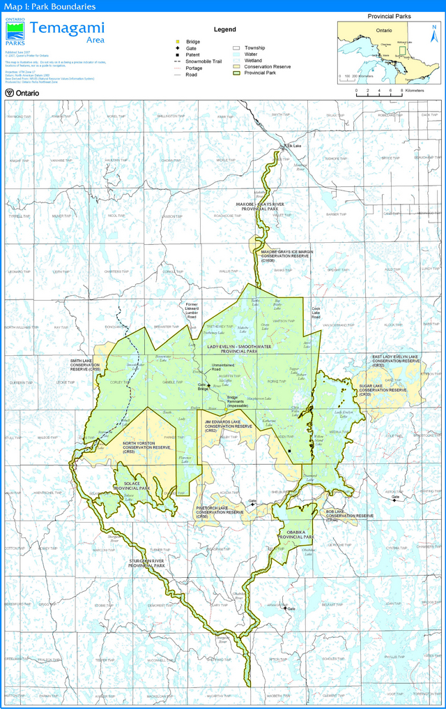
Enlarge Map 1: Park Boundaries
Map 2: Zoning map 1 of 3
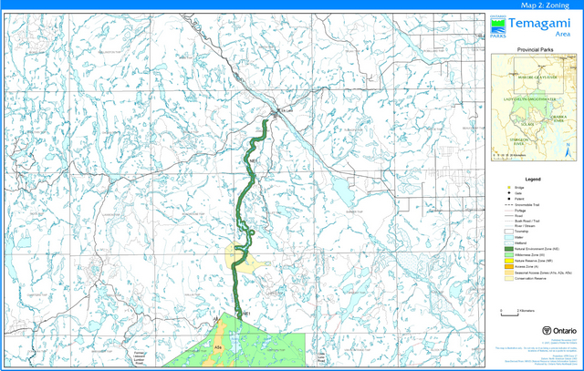
Enlarge Map 2: Zoning map 1 of 3
Map 3: Zoning map 2 of 3
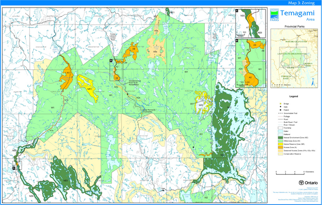
Enlarge Map 3: Zoning map 2 of 3
Map 4: Zoning map 3 of 3
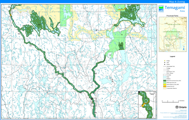
Enlarge Map 4: Zoning map 3 of 3
Map 5: Future Conditions/Development
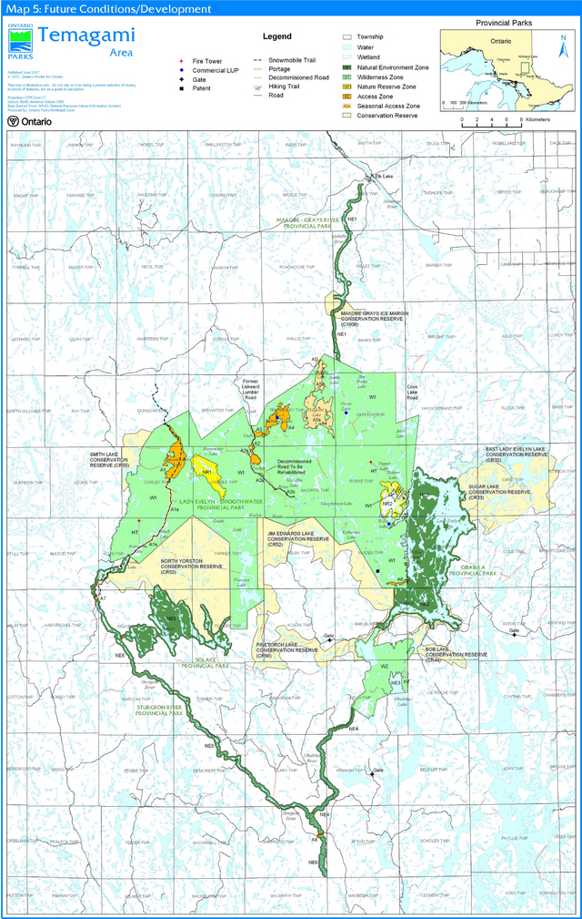
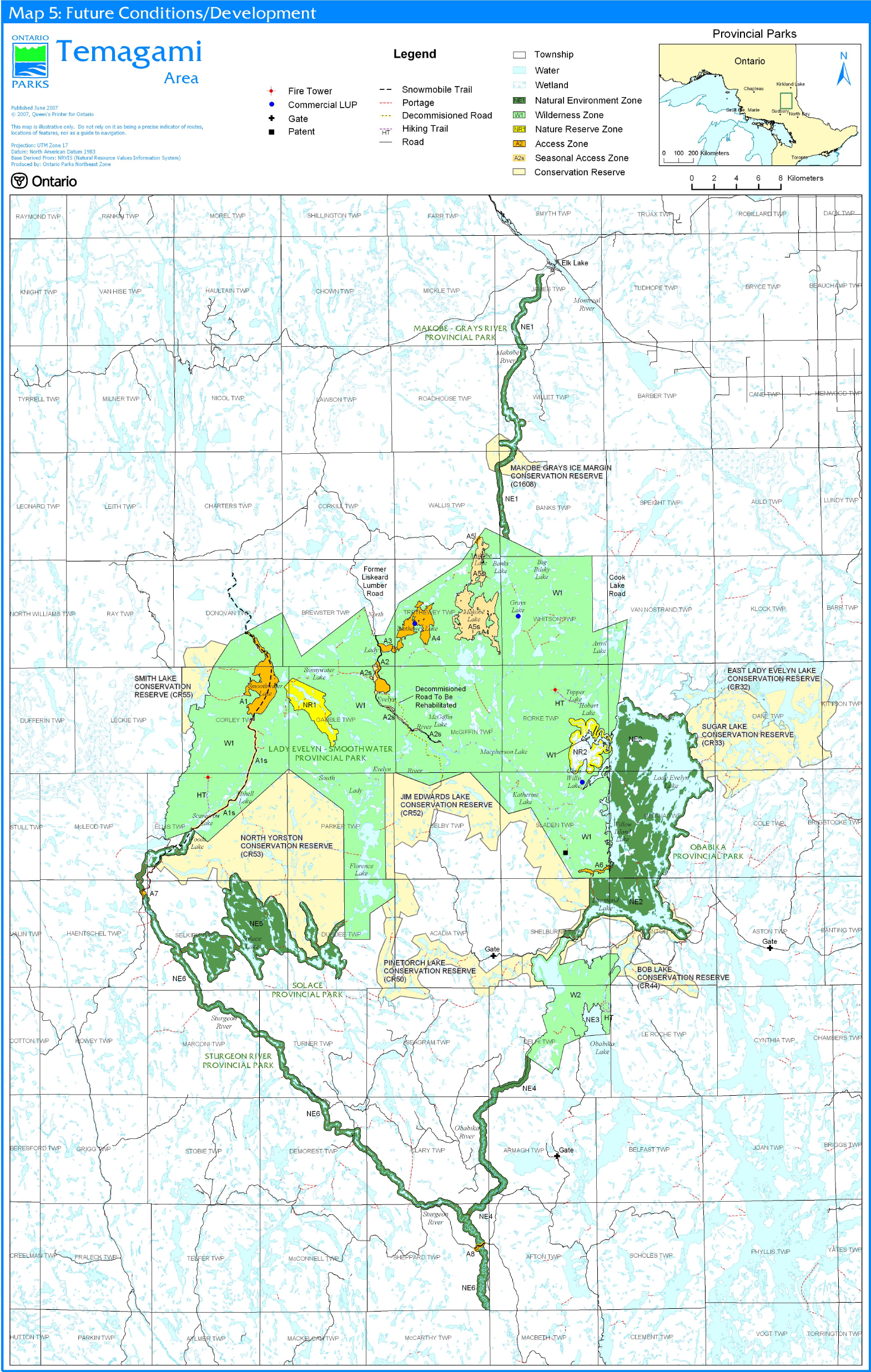
Footnotes
- footnote[1] Back to paragraph In 2006, the federal and provincial governments released the Recovery Strategy for the Aurora Trout (Salvelinus fontinalis timagamiensis) in Canada. The primary long-term goal of the strategy is to maintain secure self-sustaining Aurora trout populations in Whirligig Lake and Whitepine Lake.
- footnote[2] Back to paragraph SARO – Species at Risk in Ontario list (from MNR Species at Risk Unit) Status
- footnote[3] Back to paragraph See the Temagami Canoe Routes Planning Map
- footnote[4] Back to paragraph Note that specific road access restrictions and environmental requirements are laid out for the Red Squirrel Road in An Environmental Assessment for Primary Access Roads in the Latchford Crown Management Unit (Red Squirrel Road and Pinetorch Corridor). OMNR, 1988