Uxbridge Urban Provincial Park Management Plan
This document provides policy direction for the protection, development and management of Uxbridge Urban Provincial Park and its resources.
Approval Statement
August 7, 2025
I am pleased to approve the Uxbridge Urban Provincial Park Management Plan as the official policy for the management of this provincial park. The plan reflects the intent of the Ministry of the Environment, Conservation and Parks, Ontario Parks to protect the natural, cultural and recreational values of Uxbridge Urban Provincial Park and to maintain and develop opportunities for high quality ecologically sustainable outdoor recreation experiences and heritage appreciation for the residents of Ontario and visitors to the province.
This document outlines the site-specific objectives, policies, actions and implementation priorities related to managing the park’s natural, cultural and recreational values, and summarizes the involvement of Indigenous communities, the public and stakeholders that occurred as part of the planning process.
The plan for Uxbridge Urban Provincial Park will be used to guide the management of the park over the next 20 years. During that time, the management plan may be examined to address changing issues or conditions and may be adjusted as the need arises.
I wish to extend my sincere thanks to all those who participated in the planning process.
Jason Travers
Director, Ontario Parks
1. Introduction
Located on the Oak Ridges Moraine, a significant landform in southern Ontario, Uxbridge Urban Provincial Park protects 532 hectares (ha) of land that is important for ecological and recreational connectivity. The park is in the Township of Uxbridge, Regional Municipality of Durham (Figure 1) and within the Gunshot Treaty (Johnson-Butler Purchase) of 1787–1788 and Williams Treaties (1923). The lands are also in the traditional territories and other areas of interest for several Indigenous communities.
Indigenous communities have lived on and relied upon the lands and waters within their traditional territories and treaty areas long before Uxbridge Urban Provincial Park was established. Indigenous communities continue to rely on these lands and waters to exercise their constitutionally protected Aboriginal and treaty rights which includes various practices, customs and traditions integral to Indigenous communities’ distinctive cultures and ways of life.
Uxbridge Urban Provincial Park occurs in Oak Ridges Ecodistrict 6E-7, part of the Lake Simcoe – Rideau Ecoregion and within the Mixedwood Plains Ecozone. It contains biological features of provincial significance and representation of locally significant geological features. The landscape is mostly gently rolling to hilly and is dominated by deep morainal material. Uxbridge Urban Provincial Park includes multiple, non-contiguous disconnected parcels of land. The park provides low-intensity, self-guided and ecologically sustainable recreational opportunities in an attractive natural setting.
The planning and management of provincial parks is governed by the Provincial Parks and Conservation Reserves Act, 2006 (PPCRA). Provincial parks protect provincially significant elements of Ontario’s natural and cultural landscape and maintain biodiversity while offering opportunities for ecologically sustainable outdoor recreation.
The PPCRA dedicates provincial parks to the people of Ontario and to visitors, for their inspiration, education, health and recreational enjoyment — with the intention that these areas be primarily managed to maintain their ecological integrity and preserved for future generations.
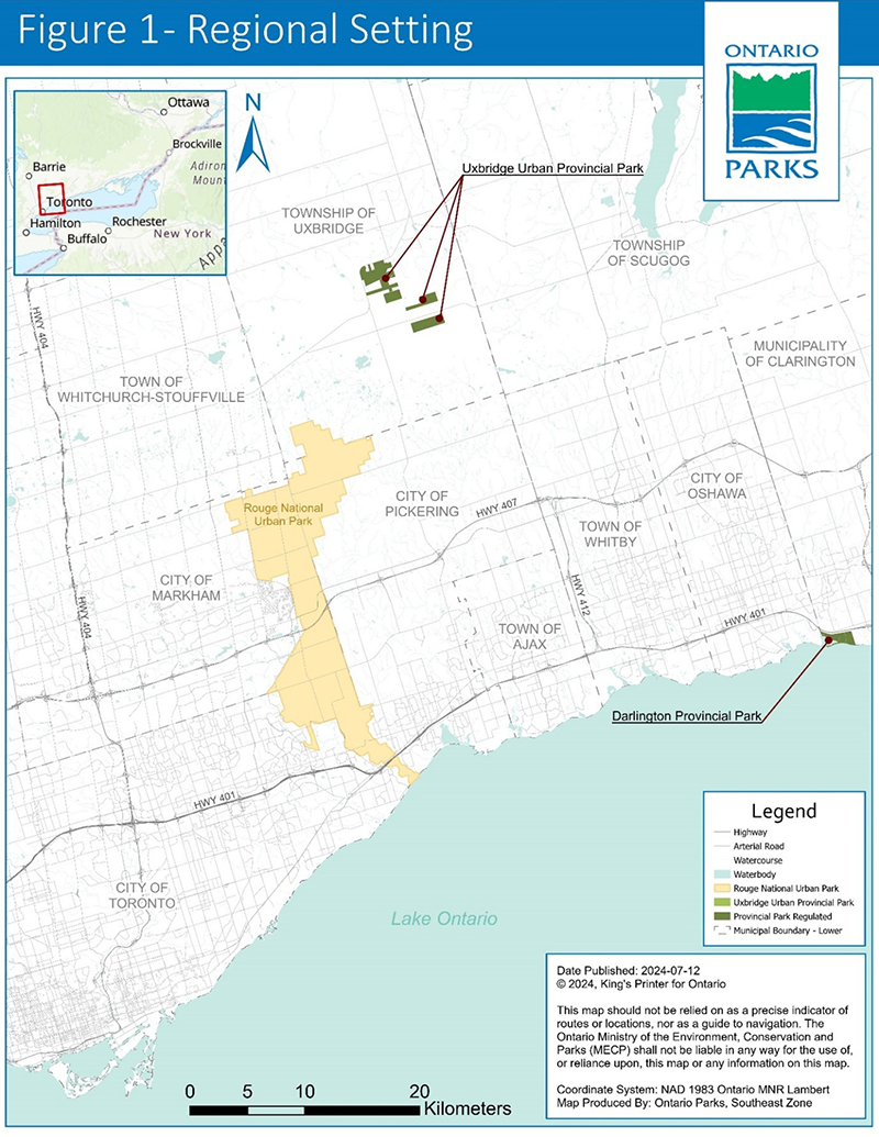
Regional setting: A map showing the location of Uxbridge Urban Provincial Park. The park is north of the city of Toronto and slightly northeast of Rouge National Urban Park.
1.1 Boundary
Uxbridge Urban Provincial Park is in the Oak Ridges Moraine Conservation Plan Area, 25 kilometers east of Newmarket and 50 kilometers northeast of Toronto (Figure 1). The park was regulated under the PPCRA in 2024.
The boundary (Figure 2) consists of non-contiguous parcels in an area of approximately 4 km by 5 km. The parcels are described as:
- An area between Regional Highway 47 at the north and west, Concession Road 6 to the east and Wagg Road to the south. The northern blocks are 264.4 ha in size.
- An area that is 63.5 ha in size and is immediately south of the northern blocks, across Wagg Road.
- An area further southeastward, between Concession Road 6 and Road 7, and is 84.8 ha in size.
- A southernmost area that is located between Concession Road 6 and 7 and is located just south of Goodwood Road. This rectangle parcel is 125.3 ha in size.
Ontario Parks and planning partners are reviewing the area surrounding the provincial park to identify priority land parcels for potential acquisition or inclusion within the boundary.
There is potential for new parcels to be added to the park if acquired either through donation, land transfer or purchase. The intent of Uxbridge Urban Provincial Park is to create ecological and recreational connections across the Oak Ridges Moraine. Prioritized parcels will be based on ecological and or recreational benefit to the park.
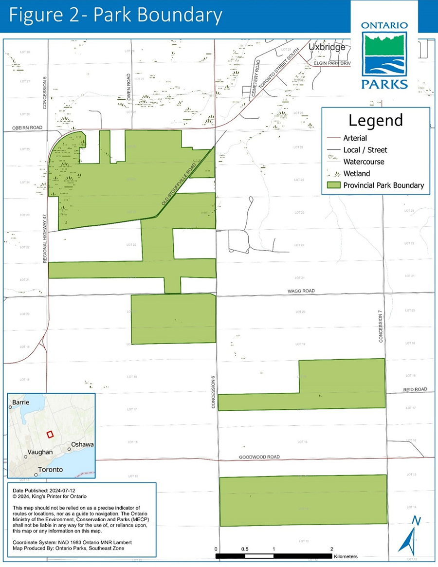
Park boundary: A map of the boundary of Uxbridge Urban Provincial Park. The park is located southwest of the town of Uxbridge and bounded by Concession Road 7 on the east and Highway 47 on the west.
1.2 Indigenous communities
Indigenous people lived on and developed relationships with the lands and waters that we now call Ontario long before the establishment of provincial parks. We understand that these relationships have formed the basis of Indigenous communities’ distinctive harvesting practices, governance structures, cultures and spirituality. Indigenous peoples continue to rely on, care for and renew their connections to the lands and waters in Ontario, including traditional territories that now overlap with provincial parks.
Ontario respects Aboriginal and treaty rights recognized and affirmed by Section 35 of Canada’s Constitution Act, 1982, and is committed to meeting its constitutional obligations in respect of Indigenous peoples.
Uxbridge Urban Provincial Park is located within the areas of the Williams Treaties (1923) and the Gunshot Treaty (Johnson-Butler Purchase) of 1787-1788. Ontario Parks acknowledges that this provincial park is within Ontario’s current understanding of the traditional territories of the Chippewas of Rama First Nation, Georgina Island First Nation, and Beausoleil First Nation and adjacent to the traditional territories of Alderville First Nation, Curve Lake First Nation, Hiawatha First Nation, Mississaugas of Scugog Island First Nation. In addition, Ontario Parks understands from Kawartha Nishnawbe that their community may practice Aboriginal rights in the area of this provincial park. Ontario Parks also understands that this provincial park is within Ontario’s understanding of the primary area of interest to the Nation Huronne-Wendat (Huron Wendat) in respect of archeological values.
Some examples of practices, customs and traditions protected by Aboriginal and treaty rights may include:
- hunting
- trapping
- fishing
- gathering food for personal, social and ceremonial purposes
- traditional teachings
- ceremonial and spiritual activities
Many Aboriginal and treaty rights are connected to the natural environment and are primarily exercised on Crown lands in Ontario, including within provincial parks and conservation reserves. The Ministry of the Environment, Conservation and Parks is committed to meeting its constitutional obligations that may be owed to Indigenous communities, including the duty to consult and, where appropriate, accommodate.
Further, Ontario Parks is working to rebuild and renew relationships with Indigenous peoples based on trust and respect and to seek opportunities to protect, study and enjoy provincial parks and conservation reserves together with Indigenous communities while educating Ontarians and provincial park and conservation reserve visitors.
1.3 Planning context
Uxbridge Urban Provincial Park is administered by Ontario Parks Operations Branch, Southeast Zone — Ontario Ministry of the Environment, Conservation and Parks. In addition, the Oak Ridges Moraine Conservation Plan applies to park lands.
The PPCRA states that a management plan must be prepared for each provincial park in Ontario. The preparation of this management plan meets that requirement. Ontario’s Protected Areas Planning Manual and Guidelines: 2014 Edition (MNRF 2014) were used to guide park management planning.
This management plan has been developed consistent with all relevant legislation and provincial policies including the PPCRA and Ontario Provincial Parks: Planning and Management Policies, 1992 Update (MNR 1992). It is intended to guide park management for the next 20 years.
1.4 Ecological integrity
Planning and management principles in the PPCRA establish that:
- maintenance of ecological integrity shall be the first priority, and restoration of ecological integrity shall be considered
Ecosystems have integrity when:
- they have all the parts (both living and non-living) that you would expect to find
- natural functions and rates of change are happening normally
This management plan identifies site-specific management policies and actions intended to maintain or, where possible, restore ecological integrity.
2. Classification
Uxbridge Urban Provincial Park is a recreational class park.
Recreational class parks provide a wide variety of compatible outdoor recreation opportunities in attractive natural surroundings.
At the time of writing this plan, a new classification of park was being proposed under the PPCRA. The classification of Uxbridge Urban Provincial Park is subject to change and would take place through regulation amendment.
3. Purpose, vision and objectives
3.1 Purpose
The purpose of Uxbridge Urban Provincial Park is to provide connection:
- across the Oak Ridges Moraine
- between natural and recreational networks in other protected natural spaces
- with the adjacent urban area
- between people and nature
3.2 Vision
The vision of Uxbridge Urban Provincial Park is to build on the legacy of Oak Ridges Moraine protection by permanently protecting an area that is an inclusive space and accessible to all, and will:
- be a space that will allow for natural ecosystems to be maintained and enhanced
- encourage community collaboration between Ontario Parks, community groups municipalities and Indigenous communities
- contribute to the stewardship, protection and restoration of these lands by promoting biodiversity and enhancing ecosystem services
- build connections between people and nature that contribute to their physical and mental wellbeing
- provide access to the lands to support a range of recreational activities
- be a place for learning and research opportunities close to the GTA regarding cultural heritage, Indigenous heritage and natural heritage of Ontario
3.3 Objectives
Uxbridge Urban Provincial Park contributes to all 4 PPCRA objectives which pertain to protection, ecologically sustainable recreation, heritage appreciation and scientific research.
Protection
To permanently protect the park’s biodiversity and provincially significant elements of the natural and cultural landscape, and to maintain and enhance ecological integrity by limiting development, by restoring natural ecosystems and focusing recreational use.
Uxbridge Urban Provincial Park has unique and important features due to its location at a height of land on the Oak Ridges Moraine, the headwaters of the Uxbridge Wedge and the meeting point of 2 ecodistricts.
The protection of these lands, within a settled landscape, aims to create additional linkages with other existing protected areas. By building on the legacy of connection and protection across these lands, plants, animals and people will be able to move more freely through the landscape.
Additionally, the cultural heritage of the park is longstanding and extensive. The lands were inhabited by Indigenous people for millennia before settlers arrived in the area, and as such, there is considerable documentation of human presence and use of these lands. The protection of Indigenous and settler heritage, and the stories they tell, is necessary to understand the context in which this park exists.
Life science representation
The protection of life science values within the park is part of a greater initiative to retain natural spaces and connectivity on the Oak Ridges Moraine and within the Greenbelt. The objective of retaining connectivity through these lands will support ecological integrity and enable greater resilience in times of ecological change.
Landscape connectivity looks at how features on the ground impact the movement of species across their region. Connectivity within existing parcels can be enhanced through ecological restoration and there is potential for enhancing ecological connectivity between parcels through land acquisition. Figure 3 illustrates the existing degree of ecological connectivity in different areas of the park. Areas with higher connectivity values (yellow, orange and red areas on the map) are important corridors for wildlife to safely travel and access food, water, shelter and breeding habitat. These corridors are identified based on topography and ecosystem types.
The park has a good level of diversity and variety of species of vascular plants, birds and mammals have been recorded. The high variety of bird species is likely due to the diversity of habitat found within the park.
Priorities for protection and restoration include:
- Uxbridge-Glen Major Forests Area of Natural and Scientific Interest (ANSI)
- Pefferlaw-Uxbridge Headwaters ANSI
- provincially rare sand barrens
- provincially significant wetlands
- cold water seeps and springs
- species at risk and their habitats
- provincially and regionally significant species
- old-growth forests
- natural core areas and ecosystem connectivity (Landform Conservation Areas)
Earth science representation
The location of Uxbridge Urban Provincial Park provides a unique opportunity to protect lands at the top of the Oak Ridges Moraine, on the Goodwood Plain. The park’s soils are considered Pontypool Series soils which are well-drained, have steep slopes and are vulnerable to water and wind erosion (Barnett 2023). Retention of vegetative cover is crucial to minimize loss of topsoil and sand.
The area is an important surface water recharge area and part of an important aquifer for local municipalities. Due to the east-west orientation of the Uxbridge Wedge landform, water flows from the moraine north into Lake Simcoe and Georgian Bay, and also south into Lake Ontario.
Priorities for protection include:
- generalized protection of this part of the Oak Ridges Moraine
- retention of topsoil by ensuring that recreation policies support low-impact recreational use
- glacial deposit within the Uxbridge Wedge
- areas of high aquifer vulnerability
- surface and ground water
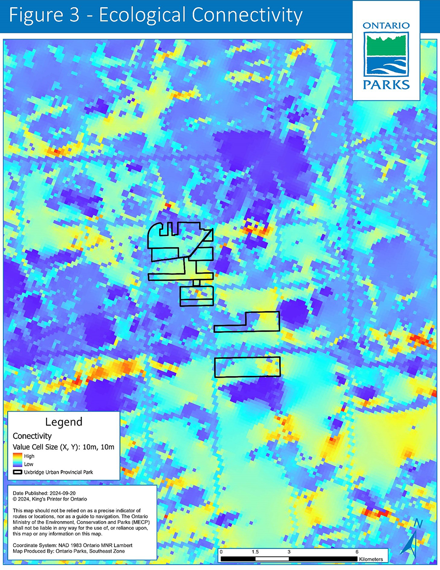
Ecological connectivity: A map showing ecological connectivity. Red, orange and yellow indicate areas of higher ecological connectivity, while light and dark blue show areas of less ecological connectivity. The boundary of Uxbridge Urban Provincial Park is shown and indicates that some parts of the park are very important for ecological connectivity (for example, species movement), while others are less important. The map shows that the park is part of a northwest to southeast band of higher ecological connectivity.
Cultural representation
The human history of Uxbridge Urban Provincial Park and the surrounding landscape dates back millennia to when Indigenous peoples moved through the area on a temporal basis (for example, with seasons). It is a cultural history that continued and changed as a result of settlement by Europeans.
Priorities for protection include:
- Indigenous values (for example, surface and ground water) or areas of interest (such as wetlands)
- areas of high archaeological potential as identified in the archaeological assessments
- existing registered archaeological sites (such as Borden sites) dating from early and mid-archaic peoples to the early 1900s
Recreation
To provide visitors with opportunities for ecologically sustainable outdoor recreation, and to encourage associated economic benefits.
Uxbridge Urban Provincial Park is in an area of high trail density that is of great recreational interest to many. The unique topography provided by the Oak Ridges Moraine landform allows for a variety of trail types and activities for enjoyment of nature throughout the year. The area where the park occurs is well used for hiking, mountain biking, cross-country skiing, snowshoeing and equestrian. Many trails connect to those that continue outside of the Regional Municipality of Durham.
Recreational priorities include:
- provide nearby and equitable non-motorized recreational opportunities to ensure that all who enter the park feel welcome and connected to nature
- formalize the park’s trail network, connect with trails on adjacent publicly accessible conservation lands and consider existing and proposed municipal recreation routes
- support the wellbeing of park visitors by providing access to green spaces where they can undertake activities that contribute to their physical and mental health
- contribute to the economic benefit of the surrounding local communities
- focus recreational opportunities in areas with minimal negative environmental impact and improving the net environmental benefit of the park through sustainable trail development and management activities
- foster a sense of collaboration to encourage engagement across diverse community groups, users or potential users
- benefit the physical and mental wellbeing of visitors and contribute to public health goals within the region
Heritage appreciation
To provide visitors with opportunities for heritage appreciation of Uxbridge Urban Provincial Park’s natural and cultural heritage.
Human use of the landscape on which Uxbridge Urban Provincial Park exists dates back millennia. There is considerable information regarding the use of park lands, initially by Indigenous peoples and then by settlers. These histories are important to understand how human use has modified the landscape of the park and the area in which it exists.
The modification of the lands because of long-time human use and settlement contributes to the natural heritage narrative. Prior to the lands being settled, the Uxbridge Urban Provincial Park area was covered in mostly grasslands and forest. The lands were then settled and converted to agriculture and residential areas. The resulting wind and water erosion due to the removal of trees and subsequent return to a forested landscape through active afforestation, are elements of the natural heritage of the lands.
Priorities for heritage appreciation:
- provide interpretation opportunities to educate visitors about the cultural and natural heritage of the park and Oak Ridges Moraine
- enable visitors to engage with nature in an urban area and to develop an appreciation for natural spaces
- encourage growth, learning and reconciliation with Indigenous peoples
Scientific research
To facilitate scientific research on a wide range of topics, including monitoring of ecological change on the broader landscape, restoration and maintenance of ecological integrity, and recreational use.
Some of the lands found within Uxbridge Urban Provincial Park have been altered by human use while others remain relatively intact. Also, adjacent lands have been highly used for a variety of recreational activities, while the park lands have been somewhat less used. In addition to contributing to foundational research conducted in Ontario Parks (for example natural and cultural heritage studies), the park also offers an opportunity to study the transition of lands from one state to another at different time scales (for example pre- and post-regulation, climate change) in the Greater Toronto Area.
Priorities for scientific research may include:
- change over time (for example evolution of natural state, impact of recreation, resource management monitoring, forest succession, climate change)
- cultural heritage
- species at risk
- provincially significant species and plant communities (for example, sand barren)
- supporting community science and efforts made by partner organizations
- ecological connection (for example, establish ecological corridors, road ecology studies, eco-passages)
- social science (for example, use of the lands over time, recreational patterns)
4. Values
4.1 Natural heritage
4.1.1 Life science
The park is within Oak Ridges Ecodistrict 6E-7, part of the Lake Simcoe–Rideau Ecoregion and within the Mixedwood Plains Ecozone. It contains biological features of provincial significance and representation of locally significant geological features. Most of the park can be characterized as deciduous forest, conifer plantation, significant wetlands, and rare sand barrens. Around 25% of the park is plantation, primarily red pine with some white pine and white spruce present. Figure 4 shows the ecosite vegetation types found in the park as identified using Ecological Land Classification (ELC). The ELC is a method for describing ecosystems using geology, climate, vegetation, terrain and soil.
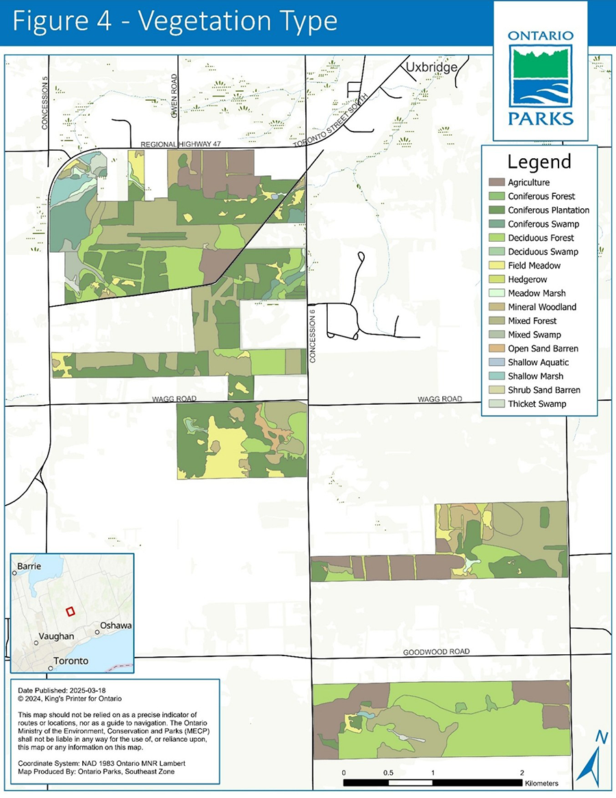
Vegetation type: A map showing a variety of vegetation types occurring in the park. Blue toned areas indicate wetlands. Yellow toned areas indicate grassland areas. Green toned areas indicate forest (both plantation and natural cover). Brown areas indicate agriculture.
The parklands include portions of two different ANSIs. The southernmost parcel includes the provincially significant Uxbridge-Glen Major Forests ANSI where there are older growth trees. The second is in the northernmost parcel, identified as a candidate regionally significant Pefferlaw-Uxbridge Headwaters ANSI, which protects provincially significant marsh and swamp complexes, extending north-east across Highway 47 and towards Uxbridge.
The park supports a rich assortment of plants and animals including several species at risk, provincially significant and regionally rare species. Two provincially significant plant communities are identified within park lands; open sand barren and shrub sand barren.
Furthermore, Uxbridge Urban Provincial Park represents the only example of inland eolian sand dunes within Ontario’s protected areas. To date, there are at least 475 species of vascular plants known to occur in the park and 44 ecosystem communities delineated through ELC. There are 3 provincial species at risk plants and 36 species in the parklands that are considered rare in the Regional Municipality of Durham. Deacon (2023) estimated that 28% of the plant species known in the park are considered introduced to Ontario.
Preliminary studies indicate that animal species designated as species at risk or are provincially tracked use the park for various life stages, at least:
- 14 bird species
- 1 insect
- 2 turtles
- 3 mammals
The high species diversity is likely due to the variability in ecosite communities within the park, as well as the increased connectivity to adjacent protected lands.
Habitat connectivity would increase if additional lands were included in the park boundary (Section 1.1).
4.1.2 Earth sciences
Formed nearly 13,000 years ago, the Oak Ridges Moraine is one of the province’s largest moraines and represents the most clearly stratified glacial sediment deposit in southern Ontario. The glacial formation and recession of the Oak Ridges Moraine caused unique landscape features along the moraine; wetland complexes can be found in kettles, and cooler-than-normal sites can potentially support northern species that are atypical to the area (MNRF 2018). The moraine was formed under and between 4 ice lobes which resulted in the unique topography of the 4 large, raised, wedge-shaped bodies of sediment (Barnett 2023). The parklands protect the core area of the Uxbridge sediment wedge, oriented east to west in the northern portion of the Oak Ridges Moraine. Two main landforms exist within the Uxbridge sediment wedge:
- the Goodwood Plains delta — a low relief plain formed by ice-contact, subglacial meltwater deposition and ice roof collapse
- the Uxbridge ridges — recessional moraines, both a result of ice margin recession northward
The topography is characterized as mostly gently rolling to hilly landscape, and is dominated by deep morainal material, primarily sand and gravel, which is highly permeable. Water is stored within the moraine along and beneath the flanks and is discharged to surrounding areas for drinking water, croplands, and pastures, as well as to support natural hydrological processes. The significance of this large, natural, recharge area for groundwater storage and distribution was recognized (Barnett 2023) and identified for source water protection. The Oak Ridges Moraine creates a unique drainage divide between Lake Ontario and Georgian Bay; the moraine feeds rivers flowing south towards the north shore of Lake Ontario as well as north towards Lake Simcoe and Georgian Bay (Barnett 2023).
The surficial soils are mostly Pontypool sand and Pontypool sandy loam with some small areas of Brighton sandy loam. The sandy and gravelly substrate led to the area being identified as a significant source area for potential aggregate extraction. The well-drained sand substrate is also susceptible to wind erosion and is less suited for intensive crop-based agriculture. This area is within the Lake Simcoe and Couchiching/Black River source protection Area; a large, natural, recharge area for groundwater storage and distribution.
4.2 Cultural heritage
The cultural heritage of Uxbridge Urban Provincial Park is lengthy and diverse. Many archaeological assessments have been done to better understand the cultural heritage of these lands. The complexity of land use over millennia means that these lands have a multitude of stories to tell. People have used these lands successfully to survive for millennia and these narratives should be well understood by those visiting Uxbridge Urban Provincial Park.
4.2.1 Pre-contact cultural heritage
Indigenous peoples live on and have cared for these lands for millennia (ASI 2022), prior to settlement by Europeans. Following the retreat of the glaciers, highly mobile populations would have adjusted to the more moderate climate and would have remained for extended periods in specific locations (ASI 2022).
In 1787-1788, the Gunshot Treaty (Johnson-Butler Purchase) was negotiated by the Crown and ultimately facilitated the settlement of the lands by non-Indigenous people and the establishment of trade routes (Surtees 1984). Given ambiguities in the previous treaty negotiations, 2 Williams Treaties were subsequently established on these lands in 1923. These treaties were signed by the Chippewas and the Mississaugas and their signing resulted in additional concessions to the Crown (Surtees 1986).
In 2018, a new negotiated settlement was reached between the Williams Treaties First Nations, Canada and Ontario regarding outstanding issues of the previous treaties (Government of Canada 2018).
Numerous archaeological assessments have been conducted for the parklands and have indicated that historically there was ongoing and consistent Indigenous presence on these lands, and some registered archaeological sites have been identified. The current use of parklands by Indigenous people and communities is not well understood at this time, however the exercise of Aboriginal and treaty rights takes place in the area such as gathering of food and medicine and ceremonial use.
4.2.2 Post-contact cultural heritage
In the early 1800s, numerous farmers and settlers arrived to these lands and created lives for themselves and their families (ASI 2017). Much of the arable lands were cleared of their natural cover (such as forests and grassland) for the purpose of agriculture, forestry and settlement (ARA 2021). Soils were determined to be of limited use for pasture, hay and grain, but drought-resistant crops such as potatoes were able to be successfully grown in the area (Olding and Wicklund 1956). By the mid-1800s, agriculture was widespread in the area (ASI 2022).
Over time, throughout the area, past land clearing practices were noted as having negative impacts on some of the sandy soils, resulting in severe wind erosion. As such, plantations of pine and spruce were established to slow the erosion (Olding and Wicklund 1956). These purposeful modifications in how the lands were used contributes to a narrative of landform modification.
In some cases, locally significant families established businesses on or adjacent to the park lands, including the Nesbitt family and the long-standing milling operation taking place in what is now the southern part of the park. The milling building and the mill itself are now housed at The Village at Black Creek in Vaughan (ARA 2021). The drive shed from the property was relocated to the Uxbridge Historical Centre (Uxbridge Historical Centre 2022).
The Nesbitt Farm property is the location where some outdoor scenes of 2 Canadian productions were filmed: Anne of Green Gables and Road to Avonlea (ARA 2020). The property is representative of a typical rural landscape of early settlement of Canada.
Immediately prior to regulation, the park itself was a mix of woodlot and agricultural use. There were no private residences.
4.3 Ecologically sustainable recreation
The Uxbridge area is known for the hundreds of kilometres of recreational trails it provides, including hiking, mountain biking and equestrian trails. Recreational values within Uxbridge Urban Provincial Park are similar to those outside of the park, including a variety of multi-use trails (See section 7.2.2 for information on trails).
The park has almost 2 km of pre-existing interlocking brick pathway that offers accessible routes through the park. The interlocking brick is ideally suited for wheelchairs, strollers and other wheeled means of transportation, and offers more even footing. The pathway does follow a variety of terrain and some parts of the trail may not be accessible for some.
Other trails offer a variety of terrain and are appropriate for hiking, mountain biking, cross-country skiing, snowshoeing and equestrian.
The trail network within Uxbridge Urban Provincial Park offers opportunities to connect with trail networks on lands owned by Toronto and Region Conservation Authority, Regional Municipality of Durham (Durham Forest) and Township of Uxbridge.
In addition to trails that offer ecologically sustainable recreation opportunities, there are locations throughout the park that offer opportunities for quiet contemplation and mindfulness, and nature appreciation such as birdwatching.
5. Summary of pressures
Given the location and historical use of the lands, various pressures affect the values in Uxbridge Urban Provincial Park. Some pressures may be addressed within the park, such as managing invasive species populations and human disturbance. Others will require adapting to or mitigating pressures that occur outside the boundary of the provincial park, such as effects from climate change, traffic, and uses on adjacent land.
Pressures on park values include:
- motorized vehicle use impacts (for example, erosion, noise pollution, user conflicts)
- trail impacts (for example, fragmentation, erosion, sedimentation)
- boundary encroachment and unauthorized activities (for example, trail creation)
- invasive species, including non-native forest pests and wildlife diseases, such as common reed (Phragmites australis), garlic mustard, dog-strangling vine and European buckthorn
- introduction of forest pests and disease
- commercial resource extraction and associated activities (for example, use of herbicide, creation of access trails, increased spread of invasive species)
- aggregate extraction outside of the park (for example, potential for changes in water quality or quantity, erosion, noise pollution)
- legacy impacts from historical settler use of the land (for example, erosion resulting from deforestation)
- unauthorized dumping
- climate change
- habitat fragmentation (for example, roads, trails, fences)
- hyperabundant wildlife
- illegal collection/poaching of natural and cultural values
- development, uses and management actions on adjacent lands (for example, construction, herbicide use, utility corridor maintenance)
- roads (for example, road salt, mortality)
6. Zoning
Zones are established in provincial parks to guide policy development and management decisions based on the sensitivity of natural and cultural values, potential for recreational uses and desired degree of development.
Distinct policies are applied to each zone to balance use and protection. Digital mapping has resulted in some variation between the regulated area under the PPCRA and the total area of the zones calculated for the management plan.
Uxbridge Urban Provincial Park has five types of zones (Figure 5):
- nature reserve
- natural environment
- historical
- access
- development
The zoning aims to establish a management system that protects undisturbed and intact environments while at the same time providing opportunities for public access via a system of approved trails. Zoning as described below may be amended pending future land acquisitions. In some cases, such as access and development zones, zoning boundaries will be determined upon implementation of policies in this plan and zone mapping is illustrative only.
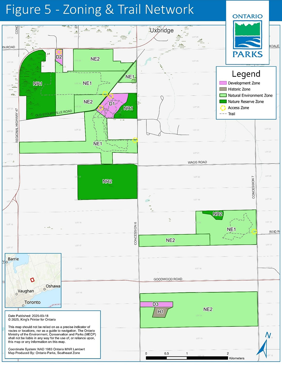
Zoning and trail network: Map shows zoning of Uxbridge Urban Provincial Park; nature reserve zones (dark green), natural environment zones (lighter green), development zones (pink), historical zone (brown) and access zones (yellow circles). The map also shows available trails.
6.1 Nature reserve zone
Nature reserve zones include natural and cultural values which require management distinct from that in adjacent zones. Trails, interpretive signs and other minimal infrastructure may be permitted. Nature reserve zones constitute 27% of the park.
NR1 Zone – Wetland (58 ha)
Description: This area protects the sensitive wetland areas in the park such as the Pefferlaw-Uxbridge Headwaters ANSI, a provincially significant marsh and swamp wetland complex in the northwest part of the park, as well as headwaters of Uxbridge Brook. It includes a walking trail to a viewing platform.
Management intent: Because the park serves as part of a connectivity corridor, this zone aims to conserve corridor integrity and provide an area for monitoring. This zone is intended to be managed primarily for research and monitoring, and heritage appreciation. The zone includes a short walking trail and viewing platform. Additional or extended trails are not permitted in NR1. This predominantly trail-free area will contribute to the nature reserve zone connectivity corridor by providing an undisturbed area for wildlife.
NR2 Zone – Sand Barren (67.2 ha)
Description: These areas protect sensitive provincially rare sand barren habitat, including a small area to the west of Concession Road 7 and a large block south of Wagg Road, between Concession Roads 5 and 6.
Management intent: Sand barren habitat is sensitive to disturbance. This zone is intended to be managed primarily to enable natural restoration and to support research and monitoring. This zone also protects grassland habitat. Development and trails are not permitted in NR2.
6.2 Natural environment zone
Natural environment zones include natural, cultural and aesthetic landscapes in which minor infrastructure such as privies, benches, trails and minimal interpretive facilities may be permitted to support low-intensity recreational activities. Most of the park (67%) is zoned as natural environment zone.
NE1 Zone – Natural Environment (129 ha)
Description: The zone consists of portions of land in all sections of the park, and is comprised of plantation, grassland, mature forest and historical agricultural fields.
Management intent: This zone is intended to provide protection to park values while also providing opportunities for nature appreciation and recreational activities, such as hiking, cycling, equestrian and cross-country skiing. Access to NE1 via Wagg Road, between Concession Road 6 and Regional Highway 47, is not permitted
NE2 Zone – Commercial Use Natural Environment (186 ha)
Description: This zone is comprised of mature forest and agricultural fields under authorization to commercial operators (Section 7.1.11.2).
Management intent: This zone reflects the use of lands for commercial agricultural and commercial maple sap harvest under pre-existing authorizations, with consideration for mitigation for species at risk and maintenance of ecological integrity.
At such a time that any of the commercial authorizations cease, that portion of NE2 will be rezoned to reflect the appropriate policies for those lands. Until a management plan amendment can take place to formally change the zone, the lands will be managed to promote park purposes and protect park values, as per applicable provincial policy.
6.3 Historical zone
Historical zones encompass the significant cultural values of a park. They generally focus on a specific site (for example, area of human occupation, building(s)) and that site’s relationship to the surrounding landscape, so they may include a protective buffer around the main feature in the zone. Development is limited to:
- trails
- necessary signs
- interpretive, educational, research and management facilities
- historical restorations or reconstruction, where appropriate.
Less than 1% of the park is zoned as historical zone.
H1 Zone – Nesbitt Farm (4.4 ha)
Description: This small zone consists of remaining structures and grounds of the Nesbitt Farm. This zone does not include agricultural fields.
Management intent: This zone will be managed to maintain the visual appeal of the main house and the associated outbuildings and may offer opportunities for settler heritage appreciation. Opportunities for educational and passive recreational uses may be provided.
6.4 Access zone
Access zones provide the main access to the park’s facilities and services. All access points existing prior to the regulation of the park have been considered and only those chosen as access zones are permitted to continue. All access zones are outlined in Figure 5. Areas of access that have been deemed inappropriate for use will no longer be authorized. Less than 1% of the park is zoned as an access zone.
A1 Zone – Park Access (<1 ha)
Description: This zone is represented by 6 access locations throughout the park. These small access locations may include limited development to support recreational use, such as parking, public washroom facilities and signage. Additional access zones will be reviewed in the future. In total, the 6 access locations comprise less than 1 ha and are located:
- 565 (southern access gate) and 579 (northern gate) Old Stouffville Road
- Across the road from 579 Old Stouffville Road (the northern access)
- Park lands on Concession Road 6 across from Durham Forest Timbers Tract
- Hwy 47 access to enable potential future access point, should the location be needed to access Development Zone D2
- 4400 Concession Road 7 to access short trail loop
Management intent: This zone is intended to provide access to the park and to support recreational opportunities on the multi-use trails.
6.5 Development zone
Development zones provide park facilities and services to support day use. Development zones currently constitute 5% of the park. Development zones may be created or modified to enable future infrastructure or as new lands are potentially added to the park.
D1 Zone – Day Use (15.2 ha)
Description: This zone encompasses areas immediately to the southeast of Old Stouffville Road. The zone is comprised of plantation, some mature forest and a small grassy open area.
Management intent: This zone is intended for day use and associated infrastructure (for example, parking), park facilities and visitor services.
D2 Zone – Highway 47 Development (3.2 ha)
Description: This small zone is located immediately to the south of Highway 47, across from Parratt Road.
Management intent: This zone is intended to provide potential future access to the park, and to provide parking facilities, should these facilities and infrastructure be needed.
D3 Zone – Nesbitt Farm Development (5.4 ha)
Description: This zone encompasses the existing driveway and adjacent area at the Nesbitt Farm.
Management intent: This zone provides potential for the development of visitor services such as parking lots and other infrastructure, should such development be needed.
Aside from the zones described above, other development zones may be created to enable the establishment of a visitor centre or other visitor infrastructure.
7. Policies
7.1 Resource management policies
7.1.1 Industrial activities
The following activities are prohibited in Uxbridge Urban Provincial Park:
- commercial timber harvest
- generation of electricity (except for in-park use)
- extracting aggregate, topsoil or peat
- prospecting, staking mining claims, developing mineral interests or working mines
- other industrial uses
7.1.2 Fisheries
Fisheries in this area are managed in accordance with the fisheries management plan for Fisheries Management Zone 17. There are no appropriate waters for recreational or sport fishing in the park, however, should fishing activities occur, they are subject to provincial and federal fisheries legislation (for example, Fish and Wildlife Conservation Act, 1997; Fisheries Act (Canada)) as set out in the Ontario Recreational Fishing Regulations Summary. At such a time that lands are added to the park that will support recreational or sport fishing, the following policies will apply:
- Ontario Parks will work collaboratively with the Ministry of Natural Resources, interested Indigenous communities and researchers to maintain and enhance native self-sustaining fish populations in the park.
- Stocking may be considered to enhance recreational fishing opportunities or aquatic ecosystem restoration where ecologically appropriate. Stocking is not permitted in nature reserve zones.
- Commercial fishing and commercial bait harvesting are prohibited in the park.
7.1.3 Wildlife
In general, wildlife will not be managed. However, animal populations (including native wildlife that is hyperabundant or has the potential to become hyperabundant) may be managed or individual animals may be controlled when essential to human health and safety, the health of the species, or to protect park values or ecological integrity.
Where population management or animal control is necessary, techniques that have minimal effects on other components of the park’s environment will be used. Wildlife population management may be undertaken directly by Ontario Parks or through partnerships under the supervision of Ontario Parks.
Projects to maintain, enhance, rehabilitate or restore native wildlife habitat, and to protect species and habitats against the effects of climate change, will be considered and implemented where feasible and appropriate.
Sport hunting is prohibited within the park. Commercial fur harvest and bear management operations are not permitted in the park.
7.1.4 Vegetation
Vegetation management will be directed toward promoting the health and diversity of native vegetation communities and the park’s ecological integrity. Projects that enhance or restore native vegetation will be considered and implemented where feasible and appropriate.
Vegetation management can occur anywhere in the park; however, focus will be on areas where significant species, habitats or vegetation communities are present.
Vegetation management actions can include, but are not limited to:
- restoring, naturalizing or enhancing natural areas (Section 7.1.9)
- native species planting or seeding
- prescribed burning (Section 7.1.8)
- re-introducing native species or enhancing native species populations, where appropriate and feasible
- controlling invasive species within the park, including along interior paths of travel for species (for example, trails), and along the park boundary (Section 7.1.7)
Where planting or seeding is necessary, species native to the eco-district will be used. Where feasible, native seeds and plants from the park, and or genetic sources of native species that originate in or near the park or eco-district will be used.
Pesticides (including herbicides, fungicides, insecticides) may be used to control invasive species (Section 7.1.7), to control insects or disease (Section 7.1.5), to protect or restore native species habitat or to protect or restore rare ecosystems. Mechanical and other non-chemical forms of vegetation removal will be the preferred alternative to chemical herbicides, if feasible and effective.
Vegetation may be managed in any zone to ensure staff and public health and safety, including routine trimming and pruning and hazard tree removal along existing trails where required. Herbicides may be used to control plants poisonous to the touch in high-traffic areas if manual options are not feasible. Hazard trees will be managed in accordance with current operational policies and best management practices. When safe to do so, mowing may be reduced to decrease the disturbance footprint in the park and to assist in restoring ecological integrity. Ontario Parks will also offer recommendations, as appropriate, to encourage municipal vegetation maintenance practices adjacent to the park boundary that align with park management interests and protection of park values (Section 4).
Trees and brush cut in the nature reserve and nature environment zones will be left to break down naturally as close as possible to where they have fallen or been felled. In the development zone and as part of ecosystem restoration activities, where natural decomposition may not be feasible, cut trees and brush may be chipped on site and or removed for use elsewhere in the park.
In cases of extreme weather events like ice or windstorms, clean up and salvage operations will follow Ontario Parks best management practices.
Aside from harvest taking place under commercial authorization, vegetation harvest for commercial use is not permitted. Vegetation harvest for personal use is not permitted except for harvesting by Indigenous people exercising Aboriginal or treaty rights.
7.1.5 Insects and disease
The occurrence of native insects and diseases is recognized as an integral component of the park’s ecology. Native insects and diseases will be allowed to progress naturally, unless there is a specific threat to the park’s natural heritage values, human safety or ecological integrity.
If an outbreak of native insect or disease species threatens the park’s natural heritage values, human safety or ecological integrity the outbreak may be controlled, if feasible, using species-specific controls whenever possible. If control is undertaken, it will be directed as narrowly as possible to the specific insect or disease, to have minimal negative effects on the surrounding environment.
7.1.6 Species at risk and rare species
The park will be managed to protect at-risk and rare species. Species at risk and their habitats will be protected in a manner consistent with the Endangered Species Act, 2007 (ESA), regulations and guidelines and other relevant policy or best practices.
The park may undertake management actions for species at risk and rare species as supported by research and directed through approved recovery strategies and government response statements or other species-specific management plans. Actions may include, but are not limited to:
- habitat restoration or enhancement
- population monitoring and enhancement
- access control in sensitive areas
- public and staff education
Existing populations may be augmented and extirpated native species may be reintroduced, if biologically feasible and desirable for perpetuating park values and maintaining or enhancing ecological integrity.
7.1.7 Alien and invasive species
Alien species are plants, animals and microorganisms introduced by human actions outside their natural past or present distribution. These species may originate from other continents, countries, provinces or from other parts of Ontario. Alien species will not be deliberately introduced into the park.
Invasive species are alien species that are harming, or likely to harm, the natural environment. Invasive species will be addressed in a manner consistent with the Invasive Species Act, 2015, regulations and guidelines, the Ontario Invasive Species Strategic Plan (MNR 2012) and other relevant guidance or best practices.
Where possible, Ontario Parks will work to eradicate or control invasive species in Uxbridge Urban Provincial Park. Invasive species control will aim to reduce or prevent impacts to native species, biodiversity, ecosystem function and recreational opportunities. Control activities will be adapted based on the best available information and may be carried out through partnerships (Section 7.3.4). Control actions may include, but are not limited to:
- manual, non-chemical and chemical forms of vegetation management (Section 7.1.4)
- monitoring effectiveness of control actions and to detect new occurrences
- access control
- public and staff education
Ontario Parks may notify adjacent landowners of invasive species management in the park and will work with landowners, when feasible and appropriate, to help manage invasive species along the park boundary.
7.1.8 Fire management
Fire management in provincial parks is guided by the Fire Management Policy for Provincial Parks and Conservation Reserves (MECP and MNDMNRF 2021b) and the associated guideline. The goal of fire management in provincial parks is to protect public safety and promote and encourage the use of fire as a natural ecological process for the maintenance and restoration of ecological integrity. Fires that pose a threat to public health and safety, property and infrastructure, or other values are a priority for suppression.
Uxbridge Urban Provincial Park is located outside of the fire region of Ontario. Municipalities provide forest fire protection services for fires that start in or spread into the park. Ontario Parks will maintain communication, as needed, with municipality staff regarding fire response and management in the park.
Prescribed burning is the deliberate, planned and knowledgeable application of fire by authorized personnel to achieve ecological or hazard reduction objectives. Resources permitting, prescribed burning activities may be considered to manage vegetation (for example, in the open field habitat to maintain grassland) through a carefully implemented plan. Prescribed burning plans for the park would be developed in accordance with the approved provincial policies, methods and protocols (for example, MNRF Prescribed Burn Manual).
7.1.9 Restoration
Ecosystems have integrity when they have all the parts (both living and non-living) that you would expect to find, and natural functions and rates of change are happening normally.
Some areas within the park have experienced deforestation, agriculture, subsequent reforestation through the establishment of plantations, and the damming of streams. All of these landscape modifications have affected the ecological integrity of the lands through loss of natural cover, disturbance of soils, impaired drainage, loss of wetland function and disruption of habitat connectivity.
A restoration strategy for disturbed areas may be prepared. Any restoration efforts within the park will focus on improving natural cover, returning the lands to a naturalized state where possible (for example, sourcing locally native seeds, plantation management), minimizing the establishment of invasive species and repairing the detrimental impacts of past land uses.
Restoration efforts will be subject to available resources. Ontario Parks may work with partners (for example, individuals or organizations) to implement restoration objectives.
7.1.10 Cultural heritage
Archaeological assessments have been conducted for Uxbridge Urban Provincial Park. These studies indicate that there are cultural heritage values within the boundary of the park. Cultural heritage values will be assessed and managed in accordance with applicable legislation and policies.
The management of cultural heritage values within Uxbridge Urban Provincial Park will be directed towards protection and providing heritage appreciation and research opportunities. Cultural heritage values that may be affected by any park projects and activities will be identified and managed (as in, protected, maintained, used and or disposed of) in accordance with the Ontario Heritage Act.
Buildings and structures will be assessed for maintenance, use, restoration or mitigation. Some structures may be modified to accommodate a possible future non-historical use (to be assessed and determined) which complements the objectives of the park.
All areas of archaeological potential that may be affected by any activities associated with park design investigations, construction, operation or maintenance will be assessed. Archaeological values shall be identified and evaluated in accordance with the Ontario Heritage Act. Impacts may include any form of soil disturbance or alteration including testing, excavating, grading, capping and filling.
Controls to protect sites will be established where required.
The removal of artefacts, or the disturbance or destruction of historical features, is illegal and prohibited.
Information regarding cultural heritage interpretation is addressed in Section 7.3.3.
7.1.11 Land management
Ontario Parks strives to protect ecological and cultural values through compatible land use planning and by encouraging sustainable land management practices within the boundary of the park.
Given the shape and orientation of Uxbridge Urban Provincial Park, the park boundary is adjacent to numerous private properties. As such, consideration will be given to those properties and the integrity of the boundary will be monitored. Ontario Parks will respond to identified encroachments as per O. Reg. 347/07.
7.1.11.1 Acquisitions
The Ministry of the Environment, Conservation and Parks supports the acquisition of land through sale or donation to enhance protection or park management. Inholdings, or adjacent lands with similar values and that enhance the park’s connectivity, would be of highest priority. If lands are offered for sale or donation, they will be evaluated for their potential contribution to park objectives. The acquisition of suitable properties would be subject to the availability of financial and human resources.
Ontario Parks is working with the Township of Uxbridge, the Toronto and Region Conservation Authority and the Regional Municipality of Durham/Lake Simcoe Region Conservation Authority, to identify priority parcels of public land to consider for acquisition for inclusion within the provincial park boundary.
7.1.11.2 Authorizations
This section presents policy for authorization to use or occupy land in the park for private, commercial, or other uses that are not for park purposes.
There are currently 4 authorizations within Uxbridge Urban Provincial Park that existed at the time of regulation of the park; three existing authorizations for agricultural use and one existing authorization for a maple syrup tapping operation. Ontario Parks will manage authorizations according to policy and continue to monitor, review and assess authorizations and their conditions.
Ontario Parks will manage authorizations as per the PPCRA and conditions of the authorizations will prioritize the protection and integrity of park values and will be consistent with the vision and objectives of Uxbridge Urban Provincial Park. Authorizations or work permits may be issued for activities such as infrastructure maintenance, building maintenance, trail maintenance and vehicle operations within the park for access purposes to support operations.
No new private or commercial land tenure for non-park purposes will be permitted in the park. The park may consider new commercial authorizations if they support park purposes.
Requests for new infrastructure will be evaluated to determine whether it meets the park objectives of protecting the lands. No new permanent infrastructure in support of the authorizations will be permitted.
7.1.11.3 Adjacent lands
Policies written for Uxbridge Urban Provincial Park pertain only to lands within the park boundary. Consideration will be paid to adjacent lands managed by conservation partners and attempts may be made to align park operations, where appropriate and possible.
7.1.12 Water management
Uxbridge Urban Provincial Park is largely within the Pefferlaw River watershed (02EC-07), however, the southern ANSI parcel partially contributes to the Nonquon River watershed (02HG-04) on the east side. There are no known water control structures within the park. At one time a dam was located on the Uxbridge Brook, however the dam failed in 2013 (LSRCA 2024) and will not be replaced. The stream will be left unmodified and unimpeded.
Maintaining hydrological integrity within the park is important given the location of the park within the Oak Ridges Moraine and the importance for local wetlands, forest communities and the watershed in general. The development of artificial water features will not be permitted.
If opportunities arise, Ontario Parks will support efforts to better understand pressures and maintain and or restore natural hydrology and water quality in the park.
7.1.13 Science and research
Inventories and monitoring may be carried out to inform park management decisions. Such efforts will be undertaken based on established methods and best practices.
Partnerships may be formed to implement research, inventorying or monitoring in the park (Section 7.3.4).
Only non-intrusive research, inventory and monitoring activities will be considered within the park. Priority will be given to projects that provide a benefit to the protected area system.
The following subject areas are particularly suitable to Uxbridge Urban Provincial Park:
- life science inventories
- ecological connectivity
- species at risk monitoring, including:
- existing populations
- impacts from park activities (for example, response to resource management actions)
- monitoring of invasive species including:
- existing populations
- impacts to park values
- response to management actions
- detecting new occurrences
- research and monitoring of ecological processes and the health of significant ecosystems, including:
- provincially rare sand barren and the wetland ecosystem (for example, hydrology, water quality, flora and fauna and species at risk)
- impacts of activities and response to resource management
- Restoration and management of plantations, degraded ecosystems
- Social science (for example, visitor monitoring)
Any government agency or external party who wishes to carry out research in Uxbridge Urban Provincial Park must obtain a research authorization letter from the park superintendent. Researchers may also need to obtain additional permits or approvals (for example, ESA permits).
7.2 Recreation management policies
7.2.1 Overnight accommodation
Overnight stays in the park are not permitted. Overnight accommodation facilities may be provided if technically feasible, demand warrants and resources allow.
7.2.2 Trails
It is the intent of Ontario Parks to manage a series of ecologically sustainable multi-use recreation trails (Figure 5) that are safe and enjoyable for a range of activities and to empower all trail users to move through the area using active and environmentally sustainable transportation. The location of Uxbridge Urban Provincial Park provides an opportunity to access adjacent or nearby recreational areas managed by others. The park also provides nearby access to the Oak Ridges Moraine Trail, Greenbelt Cycling Route and Trans Canada Trail.
Prior to the regulation of Uxbridge Urban Provincial Park, considerable unauthorized trail creation had taken place on park lands. An assessment of the existing trails will be conducted (see Section 7.3.1.3). Trails authorized to continue will be maintained and will be monitored for erosion and degradation. Trails may be redesignated as single use (for example, to minimize user conflicts, protect park values). Trails or sections of trails may be closed or relocated for safety reasons, or to prevent further erosion, trampling, rutting, widening, or other degradation of park values. Some trails may be closed and left to naturalize or will be actively decommissioned.
See Section 7.3.1.3 for development policies related to trails.
The trails at Uxbridge Urban Provincial Park vary in degree of difficulty and can be used for a variety of ecologically sustainable activities. Some trails may be designated as “quiet” or “slow” trails.
Recreational use of motorized vehicles on the trails is not permitted.
Currently, 5 multi-use trails are authorized for use. No recreational use of park lands is permitted in Zone NE2.
7.2.3 Mechanized and motorized vehicle use
Bicycles and pedal assist bikes (as in E-bikes) are permitted within the park.
Recreational use by all motorized vehicles, including, but not limited to, all-terrain vehicles (ATVs), motorized snow vehicles and dirt bikes, is not permitted in the park. Mobility aids are permitted.
The park superintendent may authorize the use of ATVs and or other vehicles, including motorized snow vehicles, for management, monitoring or emergency purposes.
Mechanized use is not permitted in nature reserve zones or NE2.
7.2.4 Equestrian
Equestrian use is permitted within specific areas of the park.
As per O. Reg. 347/07 all domestic animal waste must be removed from the park. Horse manure can be managed as per preference of the rider (for example, manure bag), however it cannot remain in the park. Dispersing manure, either on-trail or off-trail, is not permitted.
Equestrian use is permitted in NE1, on Trail C (near Old Stouffville Road) and Trail E (across from Reid Road) only.
Equestrian use is not permitted in nature reserve zones, or zones NE2 or D1, or on interlock brick trails.
7.2.5 Day use area and services for visitors
Uxbridge Urban Provincial Park offers day use areas and trails for use. Additional amenities and services may be provided if technically feasible, demand warrants and resources allow.
7.2.6 Winter use
Winter recreational use is currently limited to self-use activities such as:
- walking
- snowshoeing
- cross-country skiing
- equestrian
- snow-based cycling
Motorized snow vehicles are not permitted.
Park services and facilities (for example, washrooms, warm up areas) are not currently provided. Winter camping is not currently permitted. Formalized winter operations, including winter camping, may be provided if technically feasible, demand warrants and resources allow.
7.2.7 Sport hunting and recreational/sport fishing
Sport hunting is prohibited in the park and there are no locations for recreational or sport fishing within the park.
7.2.8 Other recreational uses
The park superintendent will use existing legislation, park policy and interim guidelines to manage emerging or other recreational uses for which there is either limited or no current provincial policy to direct their management.
7.3 Operations and development policies
Development policies identify priorities for new development as well as redevelopment of existing facilities. Development is implemented:
- through business and work program planning
- based on priority and subject to the availability of funds
- in accordance with approved site and development plans that detail the location, type and extent of development permitted
All development undertaken by Ontario Parks, or by partners on its behalf, must meet the process requirements and be carried out in accordance with approved site and development plans that meet development standards for provincial parks. All development must be consistent with park vision and objectives.
Areas proposed for development will require prior assessment for significant natural and cultural heritage values — such as species at risk — to ensure these values are identified and protected at the site. Any assessment of significant cultural heritage values will involve the appropriate Indigenous communities.
A park operations plan will be prepared to provide staff with the necessary direction to manage the park on a day-to-day basis. The park operations plan will include such topics as:
- budget
- staffing
- maintenance schedules
- signage
- enforcement
- emergency management
The provisions of the park operations plan will be consistent with park policy and Ontario Parks Operating Standards (MECP 2021).
7.3.1 Infrastructure
7.3.1.1 Buildings and structures
Maintenance, replacement and or upgrading, retrofitting or adaptive reuse of park facilities will occur as necessary, as budgets allow, and will provide continued service to park visitors and to ensure that public safety and environmental protection needs are met.
Any building or structure may be removed (for example, relocated, decommissioned or demolished) or mitigated, such as for health and safety reasons, subject to pertinent legislation and guidelines.
New buildings or structures may be developed, including, but not limited to, privies, viewing platforms, and roofed rest areas, subject to zoning policies.
A visitor centre and associated infrastructure may be built in a suitable location within the park. Although a specific location is not known at this time, the structure would be in a development zone.
7.3.1.2 Parking areas
An approach for parking will be prepared to address parking needs at Uxbridge Urban Provincial Park. This approach will be prepared with local input to address the location and size of parking areas. The approach will strive to reduce conflicts between park visitors and adjacent private landowners, and to address health and safety concerns from inappropriate parking along roadways.
All parking areas will be developed following approved site plans.
7.3.1.3 Trails
Prior to the regulation of Uxbridge Urban Provincial Park, considerable unauthorized trail creation had taken place. An assessment of the existing trails will be conducted, considering:
- user safety
- impact on ecological integrity
- degree of development (for example, trail width, trail base)
- feasibility of use and maintenance (for example, degree of difficulty, accessibility)
- strategic connections with trails outside of the park
Trails authorized to continue will be managed to minimize ecological impacts and to protect sensitive natural and cultural resources, and to withstand years of use. Some areas will be kept trail free and trail density will be considered. Action will be taken to reduce threats (including invasive species and erosion). Use and impacts will be monitored.
Trails or sections of trails may be closed or relocated for safety reasons, or to prevent further erosion, trampling, rutting, widening, or other degradation of park values. Some trails may be closed and left to naturalize or will be actively decommissioned.
Ontario Parks may develop new trails and decisions will be based on ecological sustainability, connection with adjacent trail systems and consideration of possible future use. A strategy to manage trails may be produced.
7.3.2 Commercial operations
Commercial operations existing under authorization upon establishment of the park will be permitted to continue until such a time that the operation is phased out.
No new commercial farming, extractive natural resource operations or operations for non-park purposes will be permitted. Existing operations will not be permitted to expand.
If deemed appropriate and in accordance with park objectives (for example, cultural heritage, recreation), the park may enter into commercial agreements for local economic benefit or to ensure efficient operation of the park.
7.3.3 Education and heritage appreciation
Provincial parks have a role in supporting the heritage appreciation objective in the PPCRA. The way that objective is met will vary for each park and may be adapted based on the park’s resources, and ministry direction and priorities at the time.
Uxbridge Urban Provincial Park will offer self-guided interpretive programs and products (for example, interpretive signs) in keeping with the interpretive and educational themes that have been established for the park. The park also offers self-guided recreational facilities, for example, designated hiking trails are available to those wishing to explore the park.
Interpretive programs, products and facilities can provide park visitors with a greater appreciation for and understanding of the values, stories and features of Uxbridge Urban Provincial Park. Topics for education may include, but are not limited to the following:
- life and earth science features of importance to the area (for example, Oak Ridges Moraine, species at risk, sand barrens)
- Indigenous heritage — historical land use, current land use, treaty information
- settler heritage — historical land use, Nesbitt Farm
- ecosystem Integrity — for example, restoration, connectivity, invasive species
- water and wetlands
- connecting with nature in urban environments
- benefit of spending time in nature (for example, mental health through forest bathing or mindfulness in nature)
7.3.4 Partnerships
Partnerships and collaborative efforts that contribute to achieving the park’s purpose, vision, objectives and implementation of this management plan may be considered. The stewardship of the park lands may be undertaken in partnership with local community groups.
Ontario Parks may enter into partnership agreements to meet operational needs or to meet the needs of other organizations that are consistent with the vision and objectives of Uxbridge Urban Provincial Park. This may include use of lands or infrastructure.
Activities undertaken as part of a partnership or collaborative effort must be in keeping with the PPCRA, its regulations, Ontario Parks’ policies and all other applicable legislation. Any partnership may be dissolved if terms in the agreements established upon initiation are not met.
8. Implementation priorities
The following table summarizes and prioritizes actions identified in the management plan. Implementation may be subject to:
- applicable legislation and policies (for example, Constitution Act, 1982, ESA, Ontario Heritage Act, 1990, Project Evaluation Policy)
- site planning
- the availability of financial and human resources
Implementation may include further opportunities for Indigenous, stakeholder, and public consultation, as required. Additions to the implementation priority list may take place as necessary.
Short-term priorities
Trail management
Including assessment and evaluation, and possible rerouting and decommission
- Section 7.2.2 / 7.3.1.3
Establish partnership agreements
- Section 7.3.4
Acquire and add lands to the park
- Section 7.1.11.1
Develop Resource Management Strategy
- Section 7.1
Park infrastructure evaluation and planning
- Section 7.3.1
Medium-term priorities
Trail management
- Section 7.2.2 / 7.3.1.3
Park infrastructure development, including parking lots and vault privies
Including parking lots and vault privies
- Section 7.3.1
Establish partnership agreements
- Section 7.3.4
Acquire and add lands to the park
- Section 7.1.11.1
Resource Management
- Section 7.1
Evaluation of lands for restoration/rehabilitation potential
- Section 7.1.9
Develop restoration strategy for disturbed areas (as in, plantations, agricultural fields, homestead)
- Section 7.1.9
Implement Resource Management Strategy
- Section 7.1
Occupational Authority Engagement and Management
- Section 7.1.11.2
Long-term priorities
Acquire and add lands to the park
- Section 7.1.11.1
9. Examination of the management plan
Provincial park management plans are intended to guide park management and operation for 20 years. In the case of Uxbridge Urban Provincial Park, given the potential of adding lands to the park in advance of that 20-year mark, adjustments to the management plan may take place prior to that time.
This management plan will be examined in accordance with the provisions of the PPCRA to determine whether it is still relevant, effective and current, or if adjustments or a plan replacement is needed. In circumstances where the plan is not providing sufficient direction, or to address specific issues or pressures, it can be examined, prior to the next scheduled examination, and adjusted or replaced as necessary.
10. References
- AMEC. 2013. Stage 1 & 2 Archaeological Assessment: Lot 23, Concession V, 570 Old Stouffville Rd, Uxbridge, Ontario.
- ARA. 2021. Stage 1 and 2 Archaeological Assessments Uxbridge – 571 Wagg Road Project No. D1055004 Property No. N78279 – P72884 Parts 1–2, Plan 40R-24858 Township of Uxbridge Regional Municipality of Durham Part of Lots 19–20, Concession 5 Geographic Township of Uxbridge Former Ontario County, Ontario
- ARA. 2021. Stage 1 and 2 Archaeological Assessments Uxbridge – Old Stouffville Road Property Project No. D1048626 Property No. N78279 – P72883 Township of Uxbridge Regional Municipality of Durham Part of Lots 21–23, Concession 5 Geographic Township of Uxbridge Former Ontario County, Ontario
- ARA. 2021. Stage 2 Archaeological Assessment Uxbridge – 3795 Concession Road 6 Project No. D1041998 Property No. N78279 – P72886 Township of Uxbridge Regional Municipality of Durham Part of Lots 14–15, Concession 6 Geographic Township of Uxbridge Former Ontario County, Ontario
- ARA. 2020. Cultural Heritage Evaluation Recommendation Report 3795 Concession Road 6, Uxbridge, Ontario IO Property N72879, 3795 Concession Road 6 Township of Uxbridge, Regional Municipality of Durham Lots 14-15, Concession 6, Geographic Township of Uxbridge Former Ontario County, Ontario
- ARA. 2020. Stage 3 Site-Specific Assessments BaGs-42 and BaGs-43 Uxbridge – 3795 Concession Road 6 Project No. D1041998 Property No. N78279 – P72886 Township of Uxbridge Regional Municipality of Durham Part of Lot 15, Concession 6 Geographic Township of Uxbridge Former Ontario County, Ontario
- ASI Archaeological & Cultural Heritage Services. 2022. Stage 1-2 Archaeological Assessment IO Uxbridge – 557 Highway 47 Lots 23-25, Concession 5 (Geographic Township of Uxbridge, County of Ontario) Township of Uxbridge, Regional Municipality of Durham, Ontario
- ASI Archaeological & Cultural Heritage Services. 2022. Stage 1-2 Archaeological Assessment IO Uxbridge – 591 Highway 47 Part of Lot 24 and 25, Concession 5 (Geographic Township of Uxbridge, County of Ontario) Township of Uxbridge, Regional Municipality of Durham, Ontario
- ASI Archaeological & Cultural Heritage Services. 2022. Stage 1-2 Archaeological Assessment IO Uxbridge – 4400 Concession Road 7 Part of Lots 17-18, Concession 6 (Geographic Township of Uxbridge, County of Ontario) Township of Uxbridge, Regional Municipality of Durham, Ontario
- ASI Archaeological & Cultural Heritage Services. 2017. Stage 1 Archaeological Assessment 3795 Concession Road 6 Part of Lots 14 and 15, Concession 6 (Former Township of Uxbridge, County of Ontario) Township of Uxbridge Regional Municipality of Durham, Ontario
- Archaeological Research Associates Ltd. 2021. Stage 2 Archaeological Assessment Uxbridge (Revised) – 3795 Concession Road 6 Project No. D1041998 Property No. N78279 – P72886 Township of Uxbridge Regional Municipality of Durham Part of Lots 14–15, Concession 6 Geographic Township of Uxbridge Former Ontario County, Ontario.
- Archaeological Research Associates Ltd. 2020. Cultural Heritage Evaluation Recommendation Report (revised) 3795 Concession Road 6, Uxbridge, Ontario — IO Property N72879, 3795 Concession Road 6 Township of Uxbridge, Regional Municipality of Durham Lots 14-15, Concession 6, Geographic Township of Uxbridge Former Ontario County, Ontario.
- Contentworks. 2010. Built and Landscape Resources Evaluation Report for 3795 Concession Road 6, Uxbridge, ON ORC N72879
- Endangered Species Act, 2007, S.O. 2007, c. 6
- Government of Canada. 2018. Canada, Ontario and Williams Treaties First Nations reach negotiated settlement agreement for Alderville Litigatio. Accessed on July 16, 2024.
- Invasive Species Act, 2015, S.O. 2015, c. 22
- Lake Simcoe Region Conservation Authority. 2024. Personal communication. July 10, 2024.
- Ministry of the Environment, Conservation and Parks and Ministry of Northern Development, Mines, Natural Resources and Forestry. 2021a. Fire Management Planning Guideline for Provincial Parks and Conservation Reserves, PAM 7.02.02.
- Ministry of the Environment, Conservation and Parks and Ministry of Northern Development, Mines, Natural Resources and Forestry. 2021b. Fire Management Policy for Provincial Parks and Conservation Reserves, PAM 7.02.
- Ministry of Natural Resources. 1992. Ontario Provincial Parks: Planning and Management Policies, 1992 Update. Provincial Parks and Natural Heritage Policy Branch. Toronto: Queen’s Printer for Ontario.
- Ministry of Natural Resources. 2010. Permitted Use Policy Amendment (aka “phase out”). December 20, 2010.
- Ministry of Natural Resources. 2012. Ontario Invasive Species Strategic Plan. Toronto: Queen’s Printer for Ontario.
- Ministry of Natural Resources and Forestry. 2014. Ontario’s Protected Areas Planning Manual and Guidelines: 2014 Edition. Peterborough: Queen’s Printer for Ontario.
- Ministry of the Environment, Conservation and Parks. 2021. Ontario Parks Operating Standards. Peterborough.
- Olding, A.B., and R.E. Wicklund. 1956. Soil Survey of Ontario County. Report No. 23 of The Ontario Soil Survey. Canada Department of Agriculture, Ottawa and the Ontario Department of Agriculture, Toronto.
- Ontario Heritage Act, R.S.O. 1990, c. O.18
- Premier Environmental Services Inc. 2016. Stage 1 Archaeological Overview/ Background Study 579 Old Stouffville Road, Uxbridge, Ontario
- Premier Environmental Services Inc. 2016. Stage 1-2 Archaeological Assessment of 579 Old Stouffville Road, parts of Lot 23, Concession 5, Geographic Township of Uxbridge, County of Ontario, Ontario
- Provincial Parks and Conservation Reserves Act, 2006, S.O. 2006, c. 12
- Surtees, R.J. 1986. Treaty Research Report: The Williams Treaties. Treaties and Historical Research Centre: Indian and Northern Affairs Canada. Ottawa.
- Surtees, R.J. 1984. Indian Land Surrenders in Ontario 1763-1867. Ottawa.
- Uxbridge Historical Centre. 2022. Accessed on July 15, 2024.
Appendix I: Summary of Indigenous community, public and stakeholder involvement
Indigenous community, stakeholder and public involvement are an important part of the Uxbridge Urban Provincial Park management planning process.
A variety of engagement methods have been used to seek information from Indigenous communities, stakeholders and the public regarding the future of Uxbridge Urban Provincial Park:
- Urban Provincial Park Survey (spring and summer 2023)
- Park Boundary Consultation (fall 2023)
- Background Information Document (summer 2024)
Boundary consultations
Urban provincial park survey (spring and summer 2023)
Preliminary communications regarding the creation of Uxbridge Urban Provincial Park took place in spring and summer 2023. Although not exclusively management planning related, comments were sought from the public about their interest in park uses, should the park be established. The survey, entitled “Exploring the creation of urban provincial parks,” was posted on ontario.ca between June 19, 2023 and September 4, 2023. The goal was to seek input from Indigenous communities, stakeholders and the public, and over 4,200 responses were received, including the following related to management planning:
- many indicated that nature be a top consideration in park development
- strong support for non-motorized recreational opportunities and facilities, including hiking and walking, picnic areas, mountain biking and cross country skiing.
- clear messaging that some uses are not appropriate in urban provincial parks, including snowmobiling, concessions and off-leash pet areas.
Park boundary consultation (fall 2023)
Consultation regarding the creation of a new park boundary for Uxbridge Urban Provincial Park took place between October 19, 2023, to December 3, 2023. Indigenous communities, stakeholders and the public were provided with a 45-day consultation period to provide comments regarding the establishment of the new park.
Consultation included a regulation proposal notice on the Environmental Registry of Ontario (ERO), early awareness notification letter sent to appropriate Indigenous communities, direct mailings, social media posts, an open house and presentations to Indigenous communities by request.
As a result of these consultation efforts, the ministry received a total of 118 unique responses regarding the proposed boundary for Uxbridge Urban Provincial Park. Comments received were through the ERO, by email and phone, at the open house and from presentations given. Comments included:
- 4 from Indigenous communities
- 102 from the public
- 12 from organizations
Overall, the proposal was received favourably by Indigenous communities, stakeholders and the public.
Of the responses received, 43% commented on the regulation amendment proposal specifically; a large majority of the comments (90%) were supportive of establishing the park.
Most of the responses (57%) received on the regulation amendment proposal were primarily related to management planning (for example, what uses may or may not take place within the future park). A very small number of comments received did not seem to express an opinion. None of these comments were considered when making the decision on establishing the provincial park since the comments were out of scope. Management planning related comments will be considered during the upcoming management planning for this park.
Concerns and interests raised include:
- impact on ecological integrity (such as, support for protection)
- impacts to the local community (for example, traffic, impact on services)
- impacts to adjacent landowners
- communication regarding the project
- requests made for continued engagement and collaboration with local residents, stakeholders and interest groups.
- ensuring meaningful engagement with Indigenous communities during the planning for the park
Although not related to the regulation amendment proposal, the following management planning interests were expressed:
- ensuring Indigenous history and perspectives are respected and integrated into the development, management plan and educational programing for the park
- ensure that development of the park and its operation keeps ecological integrity, hydrology and connectivity a top priority
- consider accessibility and support ecologically sustainable multi-use recreation
Comments regarding permitted uses have been considered during management planning.
Management planning consultation
Stage 1: Terms of Reference and pre-consultation engagement
During winter and spring 2024, Indigenous communities were provided with opportunities to learn about the project and offer input regarding the future management and operation of the park. The following communities were contacted and provided with the draft Terms of Reference for review and input:
- Williams Treaties First Nations
- Alderville First Nation
- Hiawatha First Nation
- Mississaugas of Scugog Island First Nation
- Curve Lake First Nation
- Chippewas of Beausoleil First Nation
- Chippewas of Georgina Island First Nation
- Chippewas of Rama First Nation
- Kawartha Nishnawbe
By request, a presentation was made to Alderville First Nation, regarding the project.
Stage 2: Release of background information document for comment
On June 13, 2024, an announcement was made by the Minister of the Environment, Conservation and Parks that management planning for Uxbridge Urban Provincial Park had started. Notification included postings on the ERO, direct notification to adjacent landowners, stakeholders and those on the project contact list, social media postings and news releases.
Indigenous communities were notified prior to the June 13, 2024 announcement and commencement of the consultation period, with an invitation to participate in the management planning process for the park. The Williams Treaties First Nations communities mentioned above, Kawartha Nishnawbe and Huron Wendat Nation received this notice.
The 45-day comment period took place between June 13, 2024, and July 28, 2024.
We received 15 comments through by email, mail or phone. We also received 63 submissions through the comment card (although some comment cards were not completed).
Overall, we heard that the information we collected was reflective of the park. A low number of respondents suggested further research on recreation, ecology and cultural heritage, although no specific sources were recommended.
Although not considered in scope for the background information document consultation period, we did continue to hear that that there is support for:
- accessible trails
- improved access via adjacent trails and public transportation
- permitting access to non-motorized users only
- providing educational on ecology and cultural history
These themes were first communicated in responses to the Exploring the creation of urban provincial parks survey, conducted in summer 2023.
In scope comments were considered when preparing the preliminary management plan for review.
Stage 3: Release of preliminary management plan for comment
Indigenous engagement and consultation
Williams Treaties First Nations communities listed above, Kawartha Nishnawbe and the Huron Wendat Nation were provided advanced notice of the consultation period on November 21, 2024.
The 60-day consultation period ran from November 27, 2024 to January 26, 2025. The invitation to comment provided a link to the ERO policy proposal and contact information for the project lead.
For those communities that did not send a response to the invitation to participate, follow up phone calls were made. Phone call attempts were made on December 12, 2024 and January 28, 2025 to seek confirmation of receipt. The Metis Nation of Ontario was included in the direct notice mailing.
Four Indigenous communities responded to requests for engagement:
- Alderville First Nation sought clarification on how the treaty area was addressed in the invitation letter. They also requested that Ontario Parks follow their Consultation Protocol and provided preliminary information regarding interests.
- Huron Wendat Nation expressed agreement that areas of high archaeological potential would be considered a protection priority and would appreciate involvement in any future archaeological assessments.
- Mississaugas of Scugog Island First Nation submitted comments to the effect that they do not support any policies included in the preliminary management plan and would prefer the lands be transferred and managed by Parks Canada.
- Chippewas of Georgina Island First Nation indicated that they appreciated that the area is going to be protected and that it is close to the urban centre.
No changes to the proposed amendment were required as a result of these comments on the proposal.
Public and stakeholder consultation
On November 27, 2024, the Uxbridge Urban Provincial Park Preliminary Management Plan was released for a 60-day period for public review and comment. The preliminary management plan was posted on the ERO, direct notices were sent to stakeholders, adjacent landowners and interested parties who had asked to be kept informed of the project. In addition, a notice was posted to social media on December 2, 2024, notices were posted around Uxbridge and a public open house was hosted on January 16, 2025 at the Uxbridge Seniors Centre.
The preliminary management plan for Uxbridge Urban Provincial Park received a total of 99 unique responses from the public and stakeholders throughout the 60-day comment period. These comments were received through the ERO and by email.
Forty-two percent (42%) of comments were either wholly supportive or partially supportive of the policies presented in the preliminary management plan. One percent (1%) of commenters were entirely opposed to the preliminary management plan.
Thirty-one percent (31%) of commenters were opposed to one specific policy in the preliminary management plan; that horses wear manure bags to prevent the dropping of manure along trails in the park. The degree of support for the remaining policies is unknown.
The remaining 25% of the comments:
- were neutral on the presented policies
- were out of scope or off topic
- were unclear
- did not express an opinion
All comments were considered.
As a result of comments received from individuals and stakeholders during the consultation period, small changes were made throughout preliminary management plan pertaining to:
- trail use and management
- Ecology related topics (for example, restoration, management of invasive species)
- mapping
- editorial and terminology changes to clarify intent
In response to comments regarding the use of manure bags and that they were a hindrance to animal movement and protection (for example, from bugs), and that riders and horses could be injured as a result of their use, edits to Section 7.2.4: Equestrian have been made:
- Rather than requiring equestrians to equip their horses with manure bags, the management plan now refers specifically to O. Reg. 347/07 under the Provincial Parks and Conservation Reserves Act, 2006 and the policy reads:
- “… all domestic animal waste must be removed from the park… as per preferences of the rider (for example, manure bag)… Dispersing manure, either on-trail or off-trail, is not permitted.”
- Equestrian trail users can choose how to manage horse manure, however, it cannot be left in the park, either on-trail or off-trail.
Stage 4: Release of the approved management plan
The approved Uxbridge Urban Provincial Park Management Plan was released to the public on August 8, 2025. A policy decision notice associated with the approved park management plan was posted on the ERO. Indigenous communities, adjacent landowners, local stakeholders and the Ontario Parks contact list were notified of the release of the approved park management plan. Notification was also sent to people who submitted comments or requested to be added to the project mailing list. The approved management plan is available on the Ontario.ca website.
Ontario Parks will retain on file reference copies of the terms of reference, background information, preliminary management plan and the approved management plan. Additional copies of this publication are available from:
Uxbridge Urban Provincial Park
c/o
Ontario Parks Southeast Zone
300 Water St., Peterborough, ON
planning.sez@ontario.ca
ISBN 978-1-4868-9155-9 (PDF)
ISBN 978-1-4868-9154-2 (html)
Footnotes
- footnote[1] Back to paragraph All access points existing prior to the regulation of the park have been considered and only those areas chosen as access zones are permitted to continue (Section 6.4).